Earthquakes & Tsunamis
|
|
|
- Lilian Benson
- 9 years ago
- Views:
Transcription
1 Improving GNSS for Future Natural Disaster Reduction: Earthquakes & Tsunamis Kenneth W. Hudnut U. S. Geological Survey GNSS Science & Technology Applications ICG-3 Muloh, Sumatra December 9, 2008 Pasadena, California GPS site & photo by J. Galetzka

2 San Francisco - 5:12 AM on April 18, 1906 May 1900 April 1906 Photos courtesy Carol Prentice, USGS 3000 people were killed; 225,000 of the 400,000 living in San Francisco were left homeless. Much of the city was in ruins.

3 December 26, 2004 Sumatra-Andaman earthquake and Indian Ocean Tsunami

4 Earthquakes are a global problem

5 Earthquake Fatalities and Population Growth Cumulative number of earthquake fatalities(millions) Population (billions) 1 Courtesy of Prof. Roger Bilham (University of Colorado)
 1600 1700 1800")
6 GNSS timing for precise earthquake location worldwide - also vital for tsunami alerts

7 Courtesy of Prof. Tanya Atwater, UCSB

8 Courtesy of Prof. Tanya Atwater, UCSB

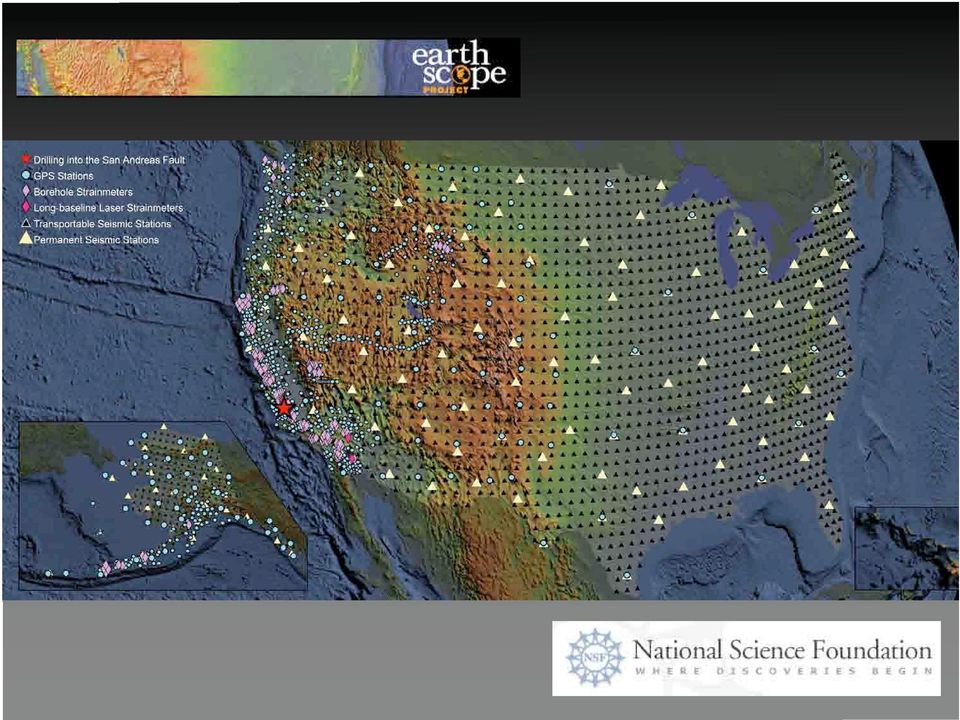
9 San Andreas fault 35 mm/yr slip rate; >70% of plate motion 1685, 1812, 1857 eq s Big Bend compression 1971 Sylmar (M 6.7) 1994 Northridge (M 6.7) California is now very heavily wired with many GPS stations GPS measures plate motion strain accumulation and large earthquake displacements Natural laboratory to study future Big Ones B4 - Imaged by airborne LiDAR - GPS was crucial!

10

11 Reid s s theory of Elastic Rebound H. F. Reid Triangulation networks were resurveyed in the 15 months following the 1906 earthquake.

12 Surveyors measure the location of mountain peaks Mt. Hamilton Loma Prieta Mt. Diablo Grizzly Peak Clayton Pre-earthquake Post earthquake

13 GPS network measures plate tectonic motions to an accuracy of better than 1 mm/yr We can see whether the motion is ʻslow and steady,ʼ or perhaps more interestingly it may sometimes accelerate or decelerate

14

15
16 San Andreas - place two bets both ~120 km from Los Angeles (LA) Coachella Valley segment is ~60 km to San Bernardino

17
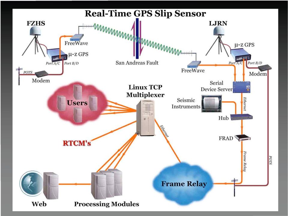
18 Lone Juniper Ranch and Frazier Park High School Prototype GPS fault slip sensor; up to 10 Hz Spans the San Andreas fault near Gorman, California

19 "Good science, when applied in the way that the people of Alaska have done, made the difference between an emergency and a tragedy." Charles Groat,, Director, United States Geological Survey Each day, the Trans-Alaska oil pipeline carries one million barrels of oil, about 17% of the domestic oil supply for the United States, valued at about $25 million. If the pipeline had ruptured during the 2002 Denali earthquake, the lost revenue and cost of repair and environmental cleanup would have been incalculable.

20 San Andreas - instrument major lifeline infrastructure crossings

21 Cajon Pass I-15 Fault Crossing
22 Earthquake Early Warning
23 Tangshan, China M ,000 people died (official) Northridge, CA it can happen here Turkey 1999
24 Automated AUTOMATED Tagging TAGGING and AND Real-Time REAL-TIME Damage DAMAGE DISTRIBUTION Distribution Maps MAPS Multiple sensor package: Acceleration / Velocity Displacement (GPS) Rotation (tilt-meter) FRC. Linear Nonlinear DIS P. Permanent displacement Pre-earthquake: Reference static displacement Reference static rotation Mean and variance of dynamic characteristics During earthquake: Changes in dynamic characteristics Hysteretic behavior Damage initiation Post-earthquake: Permanent static displacement Permanent static rotation Mean and variance of dynamic characteristics
25 REAL-TIME DAMAGE ASSESSMENT Satellite Telemetry Courtesy of Erdal Safak (USGS) Internet SENSOR PACKAGE -Accelerometer -Tiltmeter -GPS sensor
26
27 Caltech Tectonic Observatory GPS Array: SuGAr USAID funds to upgrade to real-time GNSS On-land GPS stations are essential for real-time detection of large slip: Blewitt et al. (GRL, 2006)
28 GNSS buoy systems NOAA DART buoys are expensive and require regular maintenance GPS buoys developed by GFZ and Univ. Tokyo groups GPS can be used for large numbers of low-cost buoys to complement existing system NavCom-AXYS contract for US Navy (NAVOCEANO); 2 cm inshore, 10 cm offshore NOAA-USGS testing program for warning application (MBARI) Tie in with existing earthquake and weather monitoring and alerts
29 Photo by John Galetzka Caltech Tectonic Observatory Padang - what to do?
30 Inexpensive package of GPS/INS can be added (after R&D and testing) to existing NOAA buoys offshore of So. Calif. to complement other Instrumentation for earthquake and tsunami early warning systems Photo by John Galetzka Caltech Tectonic Observatory SoCal - What to do?
31 GNSS Benefiting Humanity: Earthquake and Tsunami safety Global earthquake observation and tsunami alerts (ANSS) Airborne imagery positioning for fault zone characterization and damage assessment (B4) Tracking plates and strain accumulation and release (PBO) Earthquake early warning & rapid slip observation at lifeline fault crossings (Gorman SAF) Building monitoring and damage assessment; automatic tagging (Factor Building) Fault displacement (SuGAr) and tsunami buoy measurement (MBARI) GNSS will become even better than it is currently for these applications: GPS L2C, L5 and L1C will improve over current capabilities (e.g., tri-laning) GLONASS, QZSS, Galileo and other GNSS will help (e.g., increased coverage) GNSS could be improved beyond currently planned system enhancements: Aiding through internet or wireless will enhance real-time precise results Added signals could nearly eliminate the real-time ambiguity resolution problem
Improved Warnings for Natural Hazards: A Prototype System for Southern California
 Improved Warnings for Natural Hazards: A Prototype System for Southern California Yehuda Bock Research Geodesist Scripps Institution of Oceanography University of California San Diego, La Jolla, Calif.
EARTHQUAKE MAGNITUDE
 EARTHQUAKE MAGNITUDE Earliest measure of earthquake size Dimensionless number measured various ways, including M L local magnitude m b body wave magnitude M s surface wave magnitude M w moment magnitude
Earthquakes. Earthquakes: Big Ideas. Earthquakes
 Earthquakes Earthquakes: Big Ideas Humans cannot eliminate natural hazards but can engage in activities that reduce their impacts by identifying high-risk locations, improving construction methods, and
EARTHQUAKE PREDICTION
 Lecture 15 Earthquake Prediction EARTHQUAKE PREDICTION To successfully predict an earthquake we would like to know:- PLACE TIME MAGNITUDE (rather like a weather forecast) 1 Evidence must be integrated
Chapter 5: Earthquakes
 Chapter 5: Earthquakes 1. Experiencing an Earthquake firsthand 2. The Science of Ghost Forests and Megaearthquakes 3. Faults, Earthquakes, and Plate Tectonics 4. Seismic Waves and Earthquake Detection
THE 2004 SUMATRA EARTHQUAKE AND INDIAN OCEAN TSUNAMI: WHAT HAPPENED AND WHY
 Page 6 The Earth Scientist THE 2004 SUMATRA EARTHQUAKE AND INDIAN OCEAN TSUNAMI: WHAT HAPPENED AND WHY Seth Stein and Emile A. Okal Dept of Geological Sciences, Northwestern University, Evanston Illinois
Global Positioning System
 B. Hofmann-Wellenhof, H. Lichtenegger, and J. Collins Global Positioning System Theory and Practice Third, revised edition Springer-Verlag Wien New York Contents Abbreviations Numerical constants xix xxiii
Magnitude 7.2 GUERRERO, MEXICO
 A powerful magnitude-7.2 earthquake shook central and southern Mexico on Friday. The earthquake occurred at a depth of 24 km (15 miles). Its epicenter was in the western state of Guerrero, near the seaside
American Society of Civil Engineers
 American Society of Civil Engineers Technical Council on Lifeline Earthquake Engineering Earthquake Investigation Committee Lifelines Water and Wastewater Electric Power and Communication Gas and Liquid
[ Climate Data Collection and Forecasting Element ] An Advanced Monitoring Network In Support of the FloodER Program
![[ Climate Data Collection and Forecasting Element ] An Advanced Monitoring Network In Support of the FloodER Program](/thumbs/33/16326315.jpg "[ Climate Data Collection and Forecasting Element ] An Advanced Monitoring Network In Support of the FloodER Program") [ Climate Data Collection and Forecasting Element ] An Advanced Monitoring Network In Support of the FloodER Program December 2010 1 Introduction Extreme precipitation and the resulting flooding events
[ Climate Data Collection and Forecasting Element ] An Advanced Monitoring Network In Support of the FloodER Program December 2010 1 Introduction Extreme precipitation and the resulting flooding events
Magnitude 8.8 OFFSHORE MAULE, CHILE
 A great 8.8-magnitude struck central Chile early Saturday. The quake hit 200 miles (325 kilometers) southwest of the capital Santiago. The epicenter was just 70 miles (115 kilometers) from Concepcion,
Bridge Seismic Design, Retrofitting and Loss Assessment
 Bridge Seismic Design, Retrofitting and Loss Assessment W. Phillip Yen, Ph.D., P.E. Principal Bridge Engineer Structural Dynamics Office of Bridge Technology, FHWA Richmond, VA March 9, 2012 Outline Lessons
Earthquakes: Interesting Facts and F.A.Q.
 Earthquakes: Interesting Facts and F.A.Q. Earthquakes kill approximately 8,000 people each year and have caused an estimated 13 million deaths in the past 4,000 years. The moment magnitude scale (MMS)
Cornell University LADWP SHORT COURSE & WORKSHOP
 CASE STUDY: LIFELINE RESILIENCE- LOS ANGELES DEPARTMENT OF WATER & POWER Tom O Rourke Cornell University 1200 km2 Los Angeles N 200 km 40 km Los Angeles Department of Water and Power (LADWP) Serves 4.0
Instrument Testing and Evaluation for the Taiwan Strong-Motion Instrumentation Program
 Instrument Testing and Evaluation for the Taiwan Strong-Motion Instrumentation Program C.-C. LIU Institute of Earth Sciences, Academia Sinica, Taipei W. H. K. LEE U.S. Geological Survey, Menlo Park, CA
Advanced GIS for Loss Estimation and Rapid Post-Earthquake Assessment of Building Damage
 Advanced GIS for Loss Estimation and Rapid Post-Earthquake Assessment of Building Damage Thomas D. O Rourke and Sang-Soo Jeon, Cornell University and Ronald T. Eguchi and Charles K. Huyck, Image Cat, Inc.
Strategic Plan: 2011-2016
 1 California Integrated Seismic Network Strategic Plan: 2011-2016 Caltech CGS CalEMA UC Berkeley USGS, Menlo Park USGS, Pasadena Draft version 06: 11/15/11 Written by: CISN Program Management Group: Egill
Evolving a new Geodetic Positioning Framework: An Australian Perspective
 Evolving a new Geodetic Positioning Framework: An Australian Perspective G. Johnston, J. Dawson Outline Introduction Precise Positioning National Geospatial Reference Systems Asia Pacific Reference Frame
Using GIS for Assessing Earthquake Hazards of San Francisco Bay, California, USA
 Using GIS for Assessing Earthquake Hazards of San Francisco Bay, California, USA Marzieh Zeinali Department of Resource Analysis, Saint Mary s University of Minnesota, Minneapolis, MN 55404 Keywords: San
The Evolution of the Global Navigation Satellite System (GNSS) Spectrum Use
 Spectrum Use") The Evolution of the Global Navigation Satellite System (GNSS) Spectrum Use Spectrum Management 2012 National Spectrum Management Association Scott Pace (with thanks to Chris Hegerty, MITRE) Space Policy
The Evolution of the Global Navigation Satellite System (GNSS) Spectrum Use Spectrum Management 2012 National Spectrum Management Association Scott Pace (with thanks to Chris Hegerty, MITRE) Space Policy
Dynamic Pile Analysis Using CAPWAP and Multiple Sensors Camilo Alvarez 1, Brian Zuckerman 2, and John Lemke 3
 Dynamic Pile Analysis Using CAPWAP and Multiple Sensors Camilo Alvarez 1, Brian Zuckerman 2, and John Lemke 3 1 GRL Engineers, Inc. Los Angeles, California. (661) 259-2977 2 Berkel & Company. San Francisco,
Exploring plate motion and deformation in California with GPS
 Exploring plate motion and deformation in California with GPS Student worksheet Cate Fox-Lent, UNAVCO master teacher; Andy Newman, Georgia Institute of Technology; Shelley Olds, UNAVCO; and revised by
Tsunami Practice Questions and Answers Revised November 2008
 Tsunami Practice Questions and Answers Revised November 2008 1. What happened on 26 December 2004 off the west coast of Sumatra? 2. What is the final estimate of the magnitude of the Sumatra 26 December
A forum to discuss Global Navigation Satellite Systems (GNSS) to benefit people around the world
 to benefit people around the world") A forum to discuss Global Navigation Satellite Systems (GNSS) to benefit people around the world The International Committee on Global Navigation Satellite Systems (ICG) The United Nations General Assembly
A forum to discuss Global Navigation Satellite Systems (GNSS) to benefit people around the world The International Committee on Global Navigation Satellite Systems (ICG) The United Nations General Assembly
Chapter 7 Earthquake Hazards Practice Exam and Study Guide
 Chapter 7 Earthquake Hazards Practice Exam and Study Guide 1. Select from the following list, all of the factors that affect the intensity of ground shaking. a. The magnitude of the earthquake b. Rather
Prof. Ludovico Biagi. Satellite Navigation and Monitoring
 Prof. Ludovico Biagi Satellite Navigation and Monitoring Navigation: trajectories control positions estimations in real time, at high frequency popular applications: low accuracy (10 m) required specific
CONTRASTING DISPLACEMENT DEMANDS OF DUCTILE STRUCTURES FROM TOHOKU SUBDUCTION TO CRUSTAL EARTHQUAKE RECORDS. Peter Dusicka 1 and Sarah Knoles 2
 CONTRASTING DISPLACEMENT DEMANDS OF DUCTILE STRUCTURES FROM TOHOKU SUBDUCTION TO CRUSTAL EARTHQUAKE RECORDS Abstract Peter Dusicka 1 and Sarah Knoles 2 With the impending Cascadia subduction zone event
Trimble CenterPoint RTX Post-Processing Services FAQs
 Trimble CenterPoint RTX Post-Processing Services FAQs What is Trimble RTX technology? 30 September 2013 Trimble RTX TM (Real Time extended) is a high-accuracy, global GNSS correction technology that combines
THE STRUCTURAL HEALTH MONITORING SYSTEM OF THE RION ANTIRION BRIDGE CHARILAOS TRIKOUPIS. Akis Panagis
 InnoWeek on RES July 03,2013, Patras, Greece THE STRUCTURAL HEALTH MONITORING SYSTEM OF THE RION ANTIRION BRIDGE CHARILAOS TRIKOUPIS Akis Panagis Monitoring engineer Gefyra S.A. INDEX 1. Introduction-Structure
Kuaternion srl. Advanced Geomatics solutions: from Academy to Industry. Let s measure your World
 Kuaternion srl Let s measure your World Advanced Geomatics solutions: from Academy to Industry Co-founders and employers: Dr Andrea Nascetti, Eng PhD CEO Dr Roberta Ravanelli, Eng CTO Dr Elisa Benedetti,
GIS Characterization of the Los Angeles Water Supply, Earthquake Effects, and Pipeline Damage
 GIS Characterization of the Los Angeles Water Supply, Earthquake Effects, and Pipeline Damage by Thomas D. O Rourke, Selcuk Toprak and Sang-Soo Jeon, Cornell University Research Objectives The objectives
Lidar 101: Intro to Lidar. Jason Stoker USGS EROS / SAIC
 Lidar 101: Intro to Lidar Jason Stoker USGS EROS / SAIC Lidar Light Detection and Ranging Laser altimetry ALTM (Airborne laser terrain mapping) Airborne laser scanning Lidar Laser IMU (INS) GPS Scanning
Enabling RTK-like positioning offshore using the global VERIPOS GNSS network. Pieter Toor GNSS Technology Manager
 Enabling RTK-like positioning offshore using the global VERIPOS GNSS network Pieter Toor GNSS Technology Manager Introduction PPP/RTK Positioning Techniques PPP-AR Technology Presentation Overview PPP-AR
Interactive Plate Tectonics
 Interactive Plate Tectonics Directions: Go to the following website and complete the questions below. http://www.learner.org/interactives/dynamicearth/index.html How do scientists learn about the interior
Communications Systems Used in the USA TARNS. Chris Hill, Meteorologist in Charge (ret) National Weather Service Seattle, Washington, USA
 National Weather Service Seattle, Washington, USA") Communications Systems Used in the USA TARNS Chris Hill, Meteorologist in Charge (ret) National Weather Service Seattle, Washington, USA Washington Faces Many Non-Weather Hazards Earthquakes Tsunamis Terrorism
Communications Systems Used in the USA TARNS Chris Hill, Meteorologist in Charge (ret) National Weather Service Seattle, Washington, USA Washington Faces Many Non-Weather Hazards Earthquakes Tsunamis Terrorism
Earthquake Hazards and Risks
 Page 1 of 7 EENS 3050 Tulane University Natural Disasters Prof. Stephen A. Nelson Earthquake Hazards and Risks This page last updated on 28-Aug-2013 Earthquake Risk Many seismologists have said that "earthquakes
Center for Engineering Strong-Motion Data (CESMD)
") Center for Engineering Strong-Motion Data (CESMD) H. Haddadi 1, A. Shakal 1, C. Stephens 2, W. Savage 2, M. Huang 1, W. Leith 2, J. Parrish 1 and R. Borcherdt 2 ABSTRACT : 1 California Geological Survey,
Center for Engineering Strong-Motion Data (CESMD) H. Haddadi 1, A. Shakal 1, C. Stephens 2, W. Savage 2, M. Huang 1, W. Leith 2, J. Parrish 1 and R. Borcherdt 2 ABSTRACT : 1 California Geological Survey,
Assessment of Impact of the December 26, 2004 Tsunami In Aceh Province Indonesia
 Assessment of Impact of the December 26, 2004 Tsunami In Aceh Province Indonesia Jay H. Samek, David L. Skole, and Walter Chomentowski December 30, 2004 Center for Global Change and Earth Observations
Local monitoring by low cost devices and free and open sources softwares
 Local monitoring by low cost devices and free and open sources softwares Abstract Ludovico Biagi, Florin-Catalin Grec, Marco Negretti, Maria Grazia Visconti Politecnico di Milano, DICA@ComoCampus The purpose
Earthquakes: Risk & Insurance Issues
 Earthquakes: Risk & Insurance Issues An earthquake is a sudden and rapid shaking of the earth caused by the breaking and shifting of rock beneath the earth s surface. This shaking can sometimes trigger
The Role of Broadband in Bridge Monitoring in Minnesota. Carol Shield Department of Civil, Environmental, and Geo- Engineering
 The Role of Broadband in Bridge Monitoring in Minnesota Carol Shield Department of Civil, Environmental, and Geo- Engineering March 19, 2015 Presentation Outline A brief history of bridge testing Current
Lessons learned from the tsunami disaster caused by the 2011 Great East Japan Earthquake and improvements in JMA's tsunami warning system
 Lessons learned from the tsunami disaster caused by the 2011 Great East Japan Earthquake and improvements in JMA's tsunami warning system October 2013 Japan Meteorological Agency Lessons learned from the
Real-Time Reality by Arthur R. Andrew III, PLS
 Real-Time Reality by Arthur R. Andrew III, PLS A progressive RTK network in California deems the setting up of a base station a thing of the past. Imagine having the ability to survey using Real-Time Kinematic
A COMPUTER ANALYSIS OF THE VINCENT THOMAS SUSPENSION BRIDGE
 A COMPUTER ANALYSIS OF THE VINCENT THOMAS SUSPENSION BRIDGE 81 Raymond W. Wolfe Hany J. Farran A COMPUTER ANALYSIS OF THE VINCENT THOMAS SUSPENSION BRIDGE Civil Engineering Civil Engineering Given the
ABSG Consulting, Tokyo, Japan Email: [email protected] 2. Professor, Kogakuin University, Tokyo, Japan 3
 Application of Earthquake Early Warning System and Real-time Strong-motion Monitoring System to Earthquake Disaster Mitigation of a High-Rise Building in Tokyo, Japan Tomohiro Kubo 1, Yoshiaki Hisada 2,
Risks of future Earthquake- and extreme hydrological Disasters in Southeast Asia with a Focus on Thailand
 Risks of future Earthquake- and extreme hydrological Disasters in Southeast Asia with a Focus on Thailand Manfred Koch Department of Geohydraulics and Engineering Hydrology University of Kassel Germany
Storms Assessment LESSON
 LESSON 8 Storms Assessment What will happen to the helix above a hot lamp? TERRY G. McCREA/SMITHSONIAN INSTITUTION INTRODUCTION You have now completed Storms, the first part of Catastrophic Events. After
Locating the Epicenter and Determining the Magnitude of an Earthquake
 Locating the and Determining the Magnitude of an Earthquake Locating the Measuring the S-P time interval There are hundreds of seismic data recording stations throughout the United States and the rest
1 Introduction. External Grant Award Number: 04HQGR0038. Title: Retrieval of high-resolution kinematic source parameters for large earthquakes
 External Grant Award Number: 04HQGR0038 Title: Retrieval of high-resolution kinematic source parameters for large earthquakes Author: Hong Kie Thio URS Group Inc. 566 El Dorado Street, 2 nd floor Pasadena,
Monitoring of Natural Hazards With the ImpactSentinel Alarming System An Intelligent Solution
 Monitoring of Natural Hazards With the ImpactSentinel Alarming System An Intelligent Solution ImpactSentinel Natural Hazard Sensors und Systems hazard signalization in protection fences overstress, shock
Mitigation Works. 0 Earthquakes move mountains. But so do imagination and ingenuity when matched with implementation.
 0 Earthquakes move mountains. But so do imagination and ingenuity when matched with implementation. 0 Earthquakes have long been feared as one of nature s most damaging hazards. Earthquakes continue to
Strategic Plan. National Earthquake Hazards Reduction Program
 Strategic Plan for the National Earthquake Hazards Reduction Program Fiscal Years 2009 2013* October 2008 *Plan remains in effect and will be updated in accordance with future NEHRP Reauthorization This
Safety Culture Lessons from CSB and Other Major Incident Investigations
 Safety Culture Lessons from CSB and Other Major Incident Investigations Bill Hoyle Senior Investigator; retired U.S. Chemical Safety Board Sao Paulo, Brazil August 2014 Presentation overview Expecting
GPS/INS Integration with the imar-fsas IMU
 Sandy KENNEDY, Canada Jason HAMILTON, Canada Hugh MARTELL, Canada Key words: GPS, INS, integrated navigation, inertial navigation SUMMARY This paper discusses NovAtel's approach to GPS/INS system architecture
Peace of mind that no earthquake can shake.
 California Earthquake Authority Your Guide to Earthquake Insurance Peace of mind that no earthquake can shake. Policy information for owners of Homes and Mobilehomes. Five reasons to buy a CEA policy.
Head 168 HONG KONG OBSERVATORY
 Controlling officer: the Director of the Hong Kong Observatory will account for expenditure under this Head. Estimate... $203.4m Establishment ceiling (notional annual mid-point salary value) representing
Real Time Flood Alert System (RTFAS) for Puerto Rico
 for Puerto Rico") Prepared in cooperation with the Puerto Rico Emergency Management Agency (PREMA) Real Time Flood Alert System (RTFAS) for Puerto Rico Overview The Real Time Flood Alert System is a web-based computer program,
Prepared in cooperation with the Puerto Rico Emergency Management Agency (PREMA) Real Time Flood Alert System (RTFAS) for Puerto Rico Overview The Real Time Flood Alert System is a web-based computer program,
Keynote 2: What is Landslide Hazard? Inventory Maps, Uncertainty, and an Approach to Meeting Insurance Industry Needs
 Keynote 2: What is Landslide Hazard? Inventory Maps, Uncertainty, and an Approach to Meeting Insurance Industry Needs Jeffrey R Keaton Richard J Roth, Jr Amec Foster Wheeler Los Angeles, USA Consulting
Building a simple seismometer
 Building a simple seismometer Seismometers operate on the principle of inertia, i.e. a body at rest will tend to remain that way unless a force is applied to make it move. An ideal seismometer would be
Earthquake Magnitude
 Earthquake Magnitude Earthquake magnitude scales: Logarithmic measure of earthquake size amplitude of biggest wave: Magnitude 6 quake 10 * Magnitude 5 energy: Magnitude 6 quake is about 32 * Magnitude
EARTHQUAKES. Compressional Tensional Slip-strike
 Earthquakes-page 1 EARTHQUAKES Earthquakes occur along faults, planes of weakness in the crustal rocks. Although earthquakes can occur anywhere, they are most likely along crustal plate boundaries, such
Name: Date: Class: Finding Epicenters and Measuring Magnitudes Worksheet
 Example Answers Name: Date: Class: Finding Epicenters and Measuring Magnitudes Worksheet Objective: To use seismic data and an interactive simulation to triangulate the location and measure the magnitude
End to End Multi Hazard Early Warning Systems By Curt Barrett Hydrometeorological Consultant
 End to End Multi Hazard Early Warning Systems By Curt Barrett Hydrometeorological Consultant Disaster Risk Management- East Asia and Pacific Experts Roundtable on Urban Flood Risk Management March 17,
Plate tectonics states that the Earth's crust and upper mantle are broken into sections, called plates.
 Notes on Plate Tectonics Plate tectonics states that the Earth's crust and upper mantle are broken into sections, called plates. These plates move around the mantle. Plates are composed of the crust and
Earthquake and Volcanoes 01:460:201 Sample Syllabus
 Earthquake and Volcanoes 01:460:201 Sample Syllabus Instructor: Dr. Lauren Neitzke Adamo Dep. of Earth and Planetary Sciences Contact: [email protected] Office hours: by appointment ONLY Lectures:
Geohazards: Minimizing Risk, Maximizing Awareness The Role of the Insurance Industry
 Geohazards: Minimizing Risk, Maximizing Awareness The Role of the Insurance Industry Prof. Dr. Peter Hoeppe Head of Geo Risks Research Munich Re International Year of Planet Earth, Paris, 13 February 2008
Meteorological SPACE WEATHER SPECIAL! BRITISH ANTARCTIC SURVEY The meteorological capabilities and work of the BAS explained
 THE INTERNATIONAL REVIEW OF WEATHER, CLIMATE AND HYDROLOGY TECHNOLOGIES AND SERVICES Meteorological T E C H N O L O G Y I N T E R N A T I O N A L SPACE WEATHER SPECIAL! Exclusive interview with the UK
SMIP2000 Seminar Proceedings COSMOS VIRTUAL STRONG MOTION DATA CENTER. Ralph Archuleta
 COSMOS VIRTUAL STRONG MOTION DATA CENTER Ralph Archuleta Institute for Crustal Studies & Department of Geological Sciences University of California, Santa Barbara ABSTRACT The COSMOS virtual data center
Günter Seeber. Satellite Geodesy 2nd completely revised and extended edition
 Günter Seeber Satellite Geodesy 2nd completely revised and extended edition Walter de Gruyter Berlin New York 2003 Contents Preface Abbreviations vii xvii 1 Introduction 1 1.1 Subject of Satellite Geodesy...
Response, Recovery, and Resilience
 Response, Recovery, and Resilience KATHLEEN TIERNEY ATURAL HAZARDS CENTER NIVERSITY OF COLORADO RESILIENCE THE ABILITYOF PHYSICAL SYSTEMS AND SOCIAL UNITS TO: Mitigate Hazards Contain the Effects of Disasters
February 28 Earthquake: We got off easy
 February 28 Earthquake: We got off easy State Geologist John Beaulieu Lucky may not be the first word that comes to mind after an earthquake that injured more than 200 and caused more than $1 billion damage,
GGOS Bureau for Networks and Commuications Michael Pearlman Harvard-Smithsonian Center for Astrophysics Cambridge MA USA [email protected].
 GGOS Bureau for Networks and Commuications Michael Pearlman Harvard-Smithsonian Center for Astrophysics Cambridge MA USA [email protected] GGOS Bureau for Networks and Communications Donatello
Methane to Markets Oil and Natural Gas Technology Transfer Workshop
 Methane to Markets Oil and Natural Gas Technology Transfer Workshop Airborne Differential Absorption Lidar (DIAL) Detection and Measurement of Fugitive Emissions Steven Stearns ANGEL Service ITT Space
ENGINEERING-BASED EARTHQUAKE RISK MANAGEMENT
 ENGINEERING-BASED EARTHQUAKE RISK MANAGEMENT MRP Engineering Newsletter February 2012 The world recently experienced several major earthquakes, which caused severe local impacts and major worldwide repercussions.
TRAINING SYSTEM AND INFORMATION NETWORK FOR EARTHQUAKE DISASTER MITIGATION
 TRAINING SYSTEM AND INFORMATION NETWORK FOR EARTHQUAKE DISASTER MITIGATION T. Saito 1, N. Hurukawa 2, T.Yokoi 2, T. Hara 2, B. Shibazaki 2, Y. Fujii 2, S. Koyama 2, T. Kashima 2 and T. Mukai 2 1 International
Earthquake Preparedness Tips & Strategies
 Earthquake Preparedness Tips & Strategies What to Do BEFORE an Earthquake What to Do DURING an Earthquake BE PREPARED! For more information, log onto: www.gema.ga.gov www.ready.ga.gov www.geophysics.eas.gatech.edu
Finding location and velocity data for PBO GPS stations
 Finding location and velocity data for PBO GPS stations Original activity by Vince Cronin (Baylor University). Revisions by Beth Pratt-Sitaula (UNAVCO). Analyzing the velocities recorded at different GPS
UrEDAS, URGENT EARTHQUAKE DETECTION AND ALARM SYSTEM, NOW AND FUTURE
 3 th World Conference on Earthquake Engineering Vancouver, B.C., Canada August -6, 24 Paper No. 98 UrEDAS, URGENT EARTHQUAKE DETECTION AND ALARM SYSTEM, NOW AND FUTURE Yutaka NAKAMURA SUMMARY UrEDAS, Urgent
How To Calculate Horizontal Velocity
 The Impact of Horizontal Velocity on the APFO Ground Control Database By Louise Mathews and Joan Biediger February 2, 2012 Table of Contents Abstract... 1 Introduction and Background... 2 Plate Tectonics
Santa Ana College. EMERGENCY OPERATIONS PLAN TRAINING Table Top Exercise EARTHQUAKE SCENARIO August 16, 2013
 Santa Ana College EMERGENCY OPERATIONS PLAN TRAINING Table Top Exercise EARTHQUAKE SCENARIO August 16, 2013 Objectives Simulate Activation of SAC EOC Set up and Identify EOC Operational Sections Utilize
Geology 112 Earthquakes. Activity 1 Worksheet Introduction to the Course. What is a Fault? What is an Earthquake?
 Geology 112 Earthquakes Name Activity 1 Worksheet Introduction to the Course. What is a Fault? What is an Earthquake? Activity 1 Objectives: Introduce student to the topics, requirements and format of
Marie Tharp: Portrait of a Scientist. Presented by Hali Felt, author of the book Soundings: The Remarkable Woman Who Mapped the Ocean Floor
 Marie Tharp: Portrait of a Scientist Presented by Hali Felt, author of the book Soundings: The Remarkable Woman Who Mapped the Ocean Floor Image courtesy of the Library of Congress. Marie in the field
Chapter Overview. Bathymetry. Measuring Bathymetry. Echo Sounding Record. Measuring Bathymetry. CHAPTER 3 Marine Provinces
 Chapter Overview CHAPTER 3 Marine Provinces The study of bathymetry charts ocean depths and ocean floor topography. Echo sounding and satellites are efficient bathymetric tools. Most ocean floor features
PNT Evolution: Future Benefits and Policy Issues. Scott Pace Director, Space Policy Institute George Washington University Washington, D.C.
 PNT Evolution: Future Benefits and Policy Issues Scott Pace Director, Space Policy Institute George Washington University Washington, D.C. 5 November 2009 GPS is a Critical Component of the Global Information
Earthquake detection systems can sound the alarm in the moments before a big tremor strikes time enough to save lives
 SEISMOLOGY Earthquake detection systems can sound the alarm in the moments before a big tremor strikes time enough to save lives By Richard Allen in brief Earthquake early-warning networks detect the earliest