WRITTEN SUBMISSION FROM QUEENSFERRY AND DISTRICT COMMUNITY COUNCIL
|
|
|
- Avice Simon
- 8 years ago
- Views:
Transcription
1 WRITTEN SUBMISSION FROM QUEENSFERRY AND DISTRICT COMMUNITY COUNCIL Forth Replacement Crossing Sub-Committee The Forth Crossing Bill Report to the Scottish Parliament Transport, Infrastructure & Climate Change Committee on the proposed future use of the Forth Road Bridge as a public transport corridor 7 February 2010 Contents: Executive Summary Main Report 1. Inadequate bus priority measures to complement the corridor 4 2. Lack of measures to promote public transport growth 8 3. Current design shortfalls with Forth Road Bridge 9 4. Under utilisation of Forth Road Bridge Light Rapid Transit systems Conclusion 14 Appendix Route profile comparison 15 Executive Summary 1. Inadequate bus priority measures to complement the public transport corridor The bus right of way measures proposed through the SEStran Integrated Transport Corridor Study in 2005 do not feature in the scheme. There is a need for bus priority measures north of the Forth on the M90, A90, Castlandhill Road, and Hope Street, and on the M9 spur, M9, and Queensferry Road to the south. With no bus priority measures on the approaches to the Forth Road Bridge, the public transport corridor designation will provide little benefit in improving public transport journey times, as buses will still suffer the same delays they do at present. The proposed bus slip roads on the south side of the Forth Road Bridge will greatly increase bus journey times by routing public transport through a series of signal controlled junctions on lower speed roads than those currently used. For most of the day, the far quicker for buses will be via the Main Crossing which will offer higher running speeds and avoid buses being stopped at traffic signals. 2. Lack of measures to promote public transport growth The recommendation of the Forth Replacement Crossing Study to provide high occupancy vehicles lanes (as opposed to bus lanes) across the Forth has been ignored by Transport Scotland. The SEStran Integrated Transport Corridor Study identified the role car sharing could play in encouraging modal shift, by allowing mix and match journeys to be made across the Forth. The recommended bus Park & Ride at Halbeath and bus/rail Park & Choose at Rosyth do not feature in the scheme and are unlikely to be delivered independently of the scheme, having been recommended for immediate delivery five years ago. 3. Current design shortfalls with Forth Road Bridge There is not yet any evidence that the dehumidification system being installed will be able to halt the corrosion of the main cables. The condition of the main cable anchorage post tensing strands

2 is also an area of uncertainty. The proposed scheme relies of the Forth Road Bridge continuing to be available alongside the Main Crossing throughout its operational life. The Forth Road Bridge is vulnerable to restriction or closure during high winds precluding the use of double deck buses on services across the Forth. Any future increases in capacity will have to be provided by additional buses requiring additional drivers, rather than providing higher capacity vehicles with the same number of drivers. Therefore the incremental costs of providing additional capacity within the operational constraints of the Forth Road Bridge will be very high. The parapets fall short of current highway design standards requiring a 50mph speed restriction across the bridge. The Main Crossing will offer 70mph running therefore providing a more attractive route for express coach operators. There are safety issues for other users of the intended public transport corridor, with spacing of balusters and overall height of the barriers across the entire length of the crossing having been identified as presenting an increased risk to cyclists and pedestrians. The upgrade of these barriers is not included within the scheme. 4. Under utilisation of Forth Road Bridge The Forth Road Bridge will be carrying only 0.73% of all cross-forth traffic under the proposed scheme and will be most the expensive bus lane in the world, representing a public subsidy of around 6.25 per bus passenger journey. The approach roads on the north side of the Forth will be unable to facilitate diversions onto the Forth Road Bridge in the event of the Main Crossing being closed. 5. Light rapid transit systems Transport Scotland continues to refer to light rail as a future possible use of the public transport corridor, when in reality this is never going to happen. The SEStran Integrated Transport Corridor Study in 2005 demonstrated that an extension of the Edinburgh trams into Fife would be unviable for many reasons, because the same benefits could be achieved adequately through far cheaper options. Main Report Queensferry & District Community Council (QDCC) has objected to parts of the Forth Crossing Bill on 29 separate points. Central to these objections is the lack of a direct link to the M9 and the planned use of the Forth Road Bridge as a public transport corridor. This report explores the specific public transport issues relevant to the scheme, proposes solutions, and where relevant relates these issues back to the two main objections. References to the Bill, supporting documents and other published sources are shown as superscript within the text. 1 Inadequate bus priority measures to complement the public transport corridor 1.1 Lack of bus priority measures on northern approaches The proposed scheme does not include any of the recommended bus right of way measures identified by the SEStran Integrated Transport 1. SITCoS recommended a southbound high occupancy vehicle lane on the M90 between Halbeath and the northern bridgehead. This would be supported by bus priority in south Fife and along the A At present, buses experience delays on approach to the Forth Road Bridge in the morning peak as a result of congestion on the M90/A90, Castlandhill Road and Hope Street. Castlandhill 1 Corridor Study MVA et al, May 2005.

3 Road is used by express bus services serving Dunfermline and Rosyth. Hope Street is used by local services serving Inverkeithing and North Queensferry as well as express services to Edinburgh originating in St Andrews, Kirkcaldy, Leven and Dalgety Bay. The M90/A90 is used by intercity coach services from Aberdeen, Inverness and Perth as well as an express bus service from St Andrews via Cupar and Glenrothes. The presence of the Ferrytoll Park & Ride facility on the north-east corner of the Ferrytoll junction focuses all bus services onto the junction. The congestion is caused by the high volume of traffic joining the A90 at the Ferrytoll junction, causing traffic speeds on the mainline to reduce as drivers slow to let vehicles join the main carriageway. The reason for this high volume of traffic joining at this junction is drivers seeking to avoid the queues on the A90 between Admiralty and Ferrytoll junctions, using Castlandhill Road and Hope Street instead. This has the knock-on affect of causing tailbacks on Castlandhill Road and through the town of Inverkeithing along Hope Street and back towards the High Street. The Ferrytoll junction itself also becomes congested with traffic queuing back onto the roundabout from the on-slip to the Forth Road Bridge. South of the Ferrytoll junction and onto the Forth Road Bridge itself, the traffic flow stabilises and is relatively free flowing In addition to the longer term aspiration of the M90 HOV lane, SITCoS made a number of short term recommendations for immediate delivery including quick win bus priority measures on the A823, A907 and within the vicinity of Rosyth. These proposals have never been taken forward by the relevant authorities and do not feature in the public transport plans as part of the Forth Crossing works With no bus priority measures proposed to improve access to the Forth Road Bridge and no additional traffic capacity on the new crossing, the designation of the Forth Road Bridge as a public transport corridor will provide absolutely no benefit whatsoever, as buses will still experience the same delays as they do at present on approach to the bridge. With a similar merging arrangement from the proposed Ferrytoll gyratory immediately before the Main Crossing, the same pattern of traffic congestion can be expected, with the Main Crossing itself relatively free-flowing but congested on the approaches. M90 HOV lane and quick win bus priority measures identified through SITCoS to be delivered as part of the scheme. 1.2 Lack of bus priority measures between public transport corridor and Edinburgh In addition to the bus priority measures already suggested through SITCoS on the Fife side of the Forth, there is a need to provide bus priority on Queensferry Road between the Barnton junction and Blackhall. Since the mid 1990s, most of the main arterial routes into the city have had greenways installed comprehensive bus lanes from the edges of the city to the centre. However Queensferry Road has had no such measures implemented despite being the main bus artery between Fife and Edinburgh. The existing A90 Queue Management System and outbound bus lane on Hillhouse Road do help buses to pass queues at these locations but buses still suffer delays on Queensferry Road itself. Delivery of bus priority lanes on Queensferry Road between Barnton and Blackhall in conjunction with the scheme. 1.3 Proposed bus slip roads between public transport corridor and A90 at South Queensferry The proposed bus slip roads between the Forth Road Bridge and the A90 at South Queensferry will result in a journey time penalty for operators using the public transport corridor. The proposed scheme will require buses to travel through two sets of traffic signals southbound and six sets of signals northbound on lower speed roads than those currently used.

4 1.3.2 At present, express services connect directly between the Forth Road Bridge and the A90 via the Echline junction underpass, which is dual three lane carriageway with a 50mph speed limit. Local services observing the South Queensferry bus stops at the Forth Road Bridge plaza require to traverse the Echline junction slip roads, as it would be unsafe to move between the bus stops and the underpass crossing the running lanes of the slip roads. This route via the signal controlled junction, which almost always involves buses stopping at the signals, takes significantly longer than travelling directly via the underpass and consequently these services are given an extra five minutes running time between Barnton and Ferrytoll Park & Ride 2. The proposed scheme will require all southbound buses to operate via the Echline junction slip roads, even if they are not stopping at the Forth Road Bridge bus stops 3. Buses will then re-join the A90 via the existing on-slip to continue onto a new segregated bus lane leading to the existing bus lane on the A90 which commences east of the Scotstoun interchange. Transport Scotland has not explained why buses will require to take this route, as the underpass will be retained for use in emergencies in the event of the Main Crossing being closed (explained further in section 4.2), so could still be used by buses under normal circumstances Northbound, buses will leave the A90 via a new bus slip road up to the B800, the access to which will be through a signal controlled junction 4. Buses will then travel along the 30mph B800 to Ferrymuir where a signal controlled crossroads is planned. Continuing up the 30mph Ferrymuir Road, buses will meet two pedestrian crossings and two sets of traffic signals on the Echline junction before proceeding onto the Forth Road Bridge via the existing on-slip. With no less than six sets of traffic signals to negotiate, this route will result in a considerably longer journey time than the present route and will provide no incentive for operators to use the public transport corridor instead of the Main Crossing. Indeed, for the vast majority of the day, the far quicker route will be via the Main Crossing which will offer higher running speeds and avoid buses being stopped at traffic signals It should be noted that the existing services available from the Forth Road Bridge stops form an important part of the overall public transport provision for South Queensferry and provide journey opportunities to destinations not offered by operators passing through the town itself (for example, journeys to Edinburgh Airport, Leith, RBS Gogarburn and Riccarton can all be made from the Forth Road Bridge stops on services which originate in Fife). These services are well used by the local community. With the journey time penalty incurred using the public transport corridor as a result of the inadequate slip roads, operators may well decide to use the Main Crossing instead which would result in a reduction in the service level available to the residents of South Queensferry It should also be noted that the proposed slip roads could not be used by buses travelling to and from the M9, therefore providing no incentive for operators to develop services along this corridor to the west of Edinburgh and West Lothian. Southbound, the slip road will connect into a segregated bus lane which will lead directly onto the existing A90 bus lane, precluding the current movement from the A90 to the M9 via the Scotstoun interchange. Northbound, the bus diverge will commence from the A90 at a point east of where the M9 joins the A90, meaning buses from the M9 would have to continue on the mainline to the Main Crossing. If operators using the M9 wished to use the Forth Road Bridge, the only available route would be via the South Queensferry junction and A904 to Echline junction. The extra time required to take this detour would provide no incentive for operators to use the public transport corridor and instead the preferred route would be via the Main Crossing. 2 Comparison of Stagecoach in Fife services X54 and 55 timetables 3 ES ES

5 1.3.6 The M9 is currently used by one bus service, the highly successful Airdirect 747 service between Inverkeithing and Edinburgh Airport. Southern approach road for Main Crossing to form direct link to M9 as per option 2 from DMRB Stage 3 Report, therefore permitting continued direct access for public transport between the Forth Road Bridge and A90/M9 without the need to use the B800 or Echline junction. 1.4 Proposed bus priority measures on B800 and Ferrymuir Road The proposed bus priority measures on the B800 and the associated removal of the Ferrymuir roundabout 5 will dissuade rather than encourage the use of the public transport corridor by bus operators. Since the construction of the M9 spur and the reclassification of the road to be B-road, the traffic volume using this road has been dramatically reduced. Where congestion formerly was regularly experienced, the road is now free flowing, even at peak times. QDCC considers it totally unnecessary therefore to install a bus lane in this location. Given that Transport Scotland s own estimates show that traffic using the B800 will reduce under the proposed scheme 6, then questions must be asked as to why bus priority measures are proposed here Part of the bus priority proposals for the B800 involves the removal of the Ferrymuir roundabout, to be replaced with a signal controlled crossroads 7. This roundabout was constructed in 1996 as part of the works to remove tolls from the Forth Road Bridge southbound, replacing a T junction. Ferrymuir Road was also widened to three lanes at this time to provide two lanes on approach to the roundabout from the west. With the development of Ferrymuir the roundabout now has four exits and provides access between South Queensferry and the retail park in addition to the B800 and Ferrymuir Road. The roundabout functions well and does not suffer any delays at peak times, as it is used mainly by local South Queensferry traffic. The present road layout has proven to be satisfactory and QDCC can see absolutely no reason therefore, why the road layout needs to remodelled. The addition of traffic signals will serve only to create longer journey times for all traffic including crucially, buses, therefore reducing the incentive for operators to use the public transport corridor. Southern approach road for Main Crossing to form direct link to M9 as per option 2 from DMRB Stage 3 Report, therefore permitting continued direct access for public transport between the Forth Road Bridge and A90/M9 without the need to use the B800 or Ferrymuir junction. 1.5 Lack of bus priority measures on M9 spur The proposed scheme includes no bus priority measures on the M9 to encourage development of bus services across the public transport corridor to the west of Edinburgh and West Lothian. The M9 spur extension seems to have done nothing more than move the location of stationary traffic from one place (the old A8000) to another (the M9 spur), at a cost of some 40million. The proposed creation of a second southbound lane on the M9 spur prior to the merge with the M9 at 5 Policy Memorandum para 28 6 ES fig 4.3c 7 Policy Memorandum para 28

6 junction 1a will merely move the blockage a little further down the road towards Newbridge roundabout Traffic delays require bus operators to provide additional resource to ensure the continuity of service in terms of extra peak buses and increased running time. With most cross-forth bus services already concentrated on the city centre, the public transport corridor will not encourage operators to develop new services to the west via the M9, since as a result of congestion on the adjoining road network they will still require a substantial investment of resource. Southern approach road for Main Crossing to form direct link to M9 as per option 2 from DMRB Stage 3 Report, therefore removing the bulk of traffic from the M9 spur and improving bus journey times from the Forth Road Bridge. 2. Lack of measures to promote public transport growth 2.1 High Occupancy Vehicle lanes The Forth Replacement Crossing Study investigated a number of possible managed crossing strategies featuring high occupancy vehicle lanes to encourage car sharing across the Forth. FRCS report 4 proposed High Occupancy Vehicle priority lanes across the Forth Road Bridge for car sharing but this advice has been ignored by Transport Scotland. A car share scheme is already in operation from the top level of Ferrytoll Park & Ride s multi-story car park SITCoS identified the role car sharing and HOV lanes could play in encouraging modal shift, by allowing mix and match journeys to be made, for example, car sharing in the morning and returning by bus in the afternoon As the scheme stands there will be no journey time saving incentive for car sharers as they too will have to use the congested new bridge. High occupancy vehicles to be permitted to cross the Forth Road bridge in addition to buses. 2.2 Park & Choose SITCoS made a number of short term recommendations for immediate delivery including a new bus-based Park & Choose site at Halbeath and expanding Rosyth rail station into a Park & Choose bus and rail interchange. These proposals have never been taken forward by the relevant authorities and do not feature in the public transport plans as part of the Forth Crossing works. Delivery of Halbeath bus Park & Ride and Rosyth bus/rail Park & Choose in conjunction with the scheme. 3. Current design shortfalls with Forth Road Bridge 3.1 Long term viability of Forth Road Bridge The decision to proceed with a narrower, single function bridge depends on the Forth Road Bridge continuing to be available alongside the new crossing throughout its operational life, but the long term viability of the Forth Road Bridge is still not known. This decision has been based solely on the findings of cable inspections in 2008 which found the rate or deterioration to be slower than first feared. There is not yet any evidence that the dehumidification system being installed will be able to halt the corrosion (Forth Road Bridge is the first bridge in the world to have the system retro-fitted and its application to suspension bridges is relatively new), and the

7 need to augment or completely replace the main cables at some point in the future remains a distinct possibility. Costs at 2006 prices range from million The condition of the post tensioning strands in the anchorages is also an area of concern. There is no access to the base of the rock tunnels and the only current monitoring possible is for movement at the strand anchor bearing plate. FETA intends to award a contract for inspection works to be carried out at the south anchorage. This will involve deep excavation and will be very hazardous for the contractors involved, working with cables under extreme tensile forces With these structural issues, the bridge s proposed role as a public transport corridor cannot be guaranteed in the long term and it may still be necessary for public transport to use the new crossing at some point. 3.2 Vulnerability of Forth Road Bridge to high winds By far the biggest problem with the design of the Forth Road Bridge is the lack of any wind shielding which leaves the bridge vulnerable to restriction or closure in inclement weather: Gusts exceeding 35mph 40mph speed restriction on bridge Gusts exceeding 45mph Bridge closed to double deck buses Gusts exceeding 50mph Bridge closed to high sided vehicles, cars with caravans, trailers, roof boxes higher than 12inches, cyclists and pedestrians; Gusts exceeding 65mph Bridge closed to all vehicles except cars; Gusts exceeding 80mph Bridge closed to all vehicles The number of days the bridge is affected by high winds varies greatly from year to year and does not follow any pattern, as shown by the below figures: Year Number of days per year where strong wind leads to diversion of wind susceptible vehicles 1 April March April March April March April March April March April March January 1999 December The vulnerability of the Forth Road Bridge to high winds precludes the use of double deck buses by operators running services across the Forth, limiting these services to lower capacity, single deck vehicles only. Even with today s long single deck buses and coaches, demand at peak times has quickly grown to fill capacity, with some peak services to and from Ferrytoll Park & Ride full. The Forth Road Bridge is the biggest obstacle to introducing additional capacity on cross-forth bus services for this reason, as any additional capacity would have to be provided in the form of more buses on the road, requiring more drivers, rather than providing double deck buses with the same number of drivers (for example 8 coaches or tri-axle single deckers per hour with approx 50 seats = 400 seats; 8 double deckers with approx 80 seats = 640). However, as the additional capacity would only be required during the peaks, this would mean either taking on part-time drivers, or using split shifts for full time drivers which are unpopular. Short shifts may also require the payment of make-up to ensure drivers received the minimum agreed pay for a shift. 8 Feasibility Study for the Replacement or Augmentation of the Main Cables Update and Interim Stage 2 Report, FETA, 22 Feb 08

8 3.2.4 Transport Scotland s assertion that buses could simply divert onto the new bridge during high winds is unworkable and demonstrates an ignorance of bus service regulation. Bus operators are strictly regulated on punctuality and reliability and the Scottish Traffic Commissioner s target for operators is 95% of journeys running to within 5mins of the scheduled time 9. If buses were required to divert onto the new bridge, the extra time taken at peak times (in the absence of any bus priority measures on approach to the Main Crossing), would result in services running late and possible disciplinary action against operators by the Scottish Traffic Commissioner depending on how regularly this happened. This would also result in a loss of confidence in the service if passengers on other parts of the route such as Rosyth, Dunfermline, Inverkeithing etc were finding their buses to be late Transport research has consistently found that the primary reason why people choose their car in preference to public transport is due to unreliability of the service 10. People will not take the bus if they cannot depend on getting to their destination on time. The local economy will suffer if people arrive late for work. The health service will be affected if people miss vital hospital or GP appointments. School pupils will miss exams if their bus for school is late. And so on and so forth. The only way to ensure the reliability of services under such conditions would be to add in additional running time for when buses did require diverting, resulting in higher costs for the operator due to an increase in paid hours and longer journey times for passengers In summary, if Transport Scotland s aspirations to achieve modal shift for cross-forth travel are to be realised, the costs to introduce additional capacity and ensure reliable services within the operational constraints of the Forth Road Bridge will be very substantial. This is one of the most compelling arguments against the dropping of bus lanes from the new bridge s deck design which would provide a more reliable route for buses to use and allow the use of double deckers. 3.3 Substandard running speed compared to Main Crossing The Forth Road Bridge parapets fall short of current highway design standards in both strength and geometric requirements in a number of elements with a wide range in the degree of inadequacy 11. A controlled impact demonstration carried out by FETA in April 2007 on an offsite replica stretch of the suspended span found that a small car of only 900kg mass travelling at 62.5mph was enough to inflict some damage on the parapets and the inadequacy of the parapets is the reason why the bridge is subject to a 50mph speed restriction The Main Crossing will offer 70mph running which modern coaches are capable of. The substandard running speed on the Forth Road Bridge, coupled with the other journey time penalties associated with accessing and exiting the bridge will further discourage the use of the public transport corridor instead of the Main Crossing. 3.4 Pedestrian and cycleway barriers In addition to buses, the role of the public transport corridor will be to accommodate other modes of sustainable transport such as walking and cycling. It is important therefore that the long term suitability of the Forth Road Bridge for these users is considered The outer barriers on the viaducts are of similar design to the barriers on the suspended spans. Given that there is a footway/cycle track immediately adjacent to the carriageway on the viaducts, the consequences of a breach of these barriers have been identified as having an increased risk to pedestrians and cyclists 12. There are other safety issues with respect to spacing of balusters and overall height on the pedestrian/cyclist parapets over the entire length of the crossing and appropriate warning signs have been displayed along the length of the 9 Practice Direction: Standards for Local Bus Services, VOSA, Nov Public attitudes to transport in England, CfIT 11 Review of Parapets and Barriers, FETA, Nov Review of Parapets and Barriers, FETA, Nov 07

9 footway/cycle tracks. If the Forth Road Bridge is to be the only available pedestrian/cycle route across the Forth then it will be essential that these parapets are replaced. 4. Under utilisation of Forth Road Bridge 4.1 Under usage of the bridge s capacity Transport Scotland s December 2008 update newsletter claims the revised scheme makes sensible use of existing infrastructure. Based on the last vehicle class data available from the tollbooths before their removal, the Forth Road Bridge would be carrying 0.73% of the total cross- Forth traffic (87,085 buses in 2006/2007 out of 11,840,338 vehicles which crossed northbound). However as the buses class counted all vehicles constructed or adapted to carry more than 16 passengers, this figure includes private hire coaches, so the actual figure for public service buses will be even lower. Current service levels are 13 services per hour per direction weekday daytime and Transport Scotland predicts 200 buses will use the bridge per day. To put this into perspective the capacity of each carriageway is 3,500-3,600 vehicles per hour. Permit continued use of the Forth Road Bridge by cars and light vans in addition to buses and taxies to provide the required capacity. 4.2 Inability to switch traffic between crossings under abnormal conditions The Forth Replacement Crossing Study investigated a number of possible twin crossing strategy options for how the new and existing bridges could operate alongside each other. FRCS Report 4 stated It is clear that any new operational arrangement must allow flexibility during abnormal conditions to ensure efficient and safe operation of the network. Abnormal conditions potentially affecting either crossing were identified as: Carriageway closure (incident / maintenance): All traffic would divert across the alternative crossing; If the closure occurred on the new crossing, the restriction on the existing bridge would be removed during the closure (with the exception possibly of heavy vehicles) to be achieved using active traffic management; Breakdown; High winds (existing crossing only) Abnormal conditions which have forced the closure of the existing bridge which could potentially occur on the new crossing have included: Spilled/shed load from heavy goods vehicle on carriageway; Breakdown of escorted abnormal load; Overturned vehicle as a result of a road traffic accident; Overturned vehicle as a result of mechanical failure; Fatal road traffic accident; Damage to temporary maintenance equipment during gale force winds Transport Scotland has ignored its consultants advice in not providing the flexibility in the new scheme to alternate between the two crossings under abnormal conditions. Transport Scotland initially proposed converting the section of the A90 at South Queensferry between the Echline junction and the Forth Road Bridge plaza to a park & ride facility. If an incident forced a closure of the Main Crossing, the only way to divert traffic onto the existing bridge would be have been via the new South Queensferry junction, the single carriageway A904 and the Echline junction slip roads. QDCC was successful in pressing for the retention of the A90 link to the Forth Road Bridge for diverting traffic under abnormal conditions, and an emergency diversion link road has now been incorporated into the scheme. However there is no emergency diversion route proposed on the north side of the Forth, and the only available diversionary route will be via the Ferrytoll gyratory slip roads, directly passing the bus access road into Ferrytoll Park & Ride. Clearly, sending such an enormous volume of traffic through this junction would have a
.")
10 devastating impact on bus services serving the park & ride facility, leading to severe delays and gridlock locally. In order to ensure the continuity of public transport during abnormal conditions, it is essential that the direct link between the A90 and the Forth Road Bridge on the north side is retained. Permit continued use of the Forth Road Bridge by cars and light vans in addition to buses and taxies to provide the required capacity and allow operational flexibility during abnormal conditions. 4.3 The most expensive bus lane in the world FETA spends around 15million per annum maintaining and operating the bridge 13. Transport Scotland s proposal will make it the most expensive bus lane in the world. The bulk of the cost is unrelated to the volume of traffic using the bridge, and goes towards necessary structural works such as painting and replacement of worn out components. Resurfacing only accounts for a small portion of the overall cost of maintaining the bridge. If the bridge was still tolled then the required toll to maintain the bridge just to carry buses would be 172 per bus or 6.25 per passenger journey if 2.4 million passengers per annum cross 14. Permit continued use of the Forth Road Bridge by cars and light vans in addition to buses and taxies to provide the required capacity. 4.4 Adverse impact of not utilising the available capacity The new bridge will have the same capacity as the existing bridge (but with the possibility of hard shoulder running). The congestion present now (3 to 4 hours each working day) will simply be transferred to the new bridge and it will be congested on the first day it opens. It is absolutely essential therefore, that the Forth Road Bridge is utilised to its optimum capacity and continued use by cars and light vans is permitted, relieving the Bridge from heavy goods vehicles. With the Forth Road Bridge not fully utilised, the congestion on the approaches to the Main Crossing will cancel out the benefit of the public transport corridor designation, as buses will be delayed by this congestion. The proposed provision of an extensive Intelligent Transport System on the approaches to the Main Crossing at a cost of 11 million shows that Transport Scotland fully expects the scheme to suffer from daily congestion. Permit continued use of the Forth Road Bridge by cars and light vans in addition to buses and taxies to provide the required capacity. 5. Light Rapid Transit systems 5.1 The Forth Crossing proposals repeatedly make reference to light rail and the possibility of the Forth Road Bridge being adapted to carry light rail in the future. However this proposal has already been shown to be unviable for many reasons. The SEStran Integrated Transport Corridor Study MVA et al, May 2005 STAG Stage 1 appraisal concluded that an extension of the Edinburgh tramlines to Fife was unlikely to be justifiable in terms of economic viability, because many of the benefits could be achieved adequately through cheaper options. It was found that extending the Edinburgh trams across the Forth to Fife would not necessarily offer a step change in travel times or opportunities. 13 Budget 2008/2009, FETA, Feb Stagecoach launches Scotland s first carbon neutral bus network, Stagecoach Group press release, 29 April 08

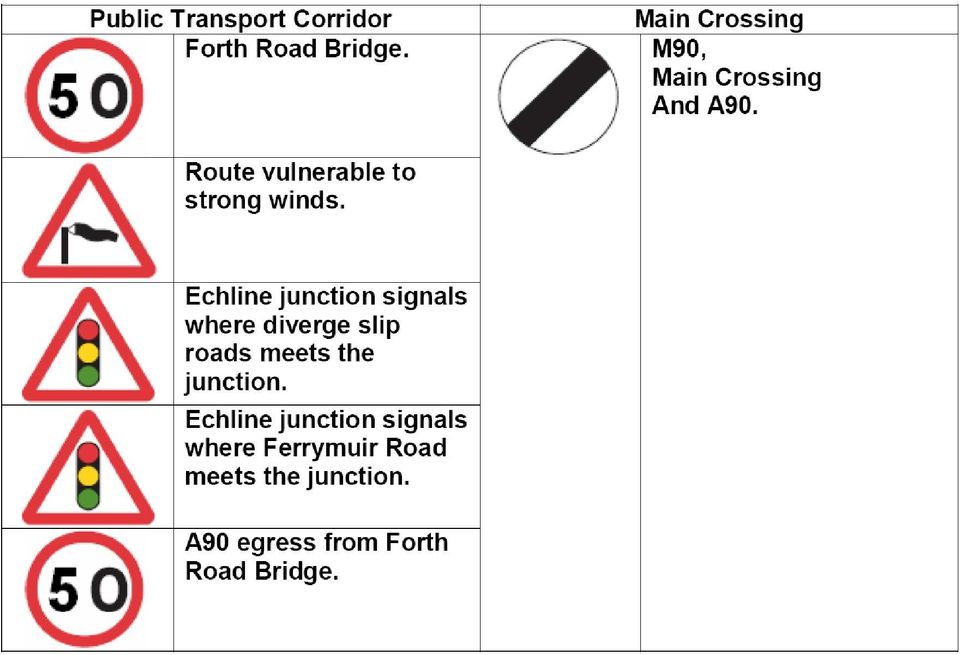
11 In addition, a large proportion of predicted demand would be abstracted from parallel public transport services (bus and heavy rail) meaning actual modal shift from cars would be negligible. In addition, given the predicted demand on the tram network, additional tram vehicles would need to be provided simply to maintain capacity between the city centre and the airport, making the incremental cost of an extension into Fife very high. 5.2 Notwithstanding the prohibitive cost factors, the decision to drop light rail provision from the design of the new bridge effectively rules this option out for good. Transport Scotland stated categorically in the public information events in 2007 that the existing Forth Road Bridge cannot accommodate a LRT system unless the deck is completely replaced. It was only when the cutprice plan for the narrower bridge design was announced in December 2008 that Transport Scotland conveniently changed its mind about the capability of the Forth Road Bridge to accommodate such a system. It is clear therefore that the continued references to light rail are little more than an attempt to talk up the scheme as providing a development opportunity for public transport, when in reality Transport Scotland knows full well that light rail to Fife is never going to happen. 6. Conclusion The public transport element of the proposed scheme in its current is completely inadequate. It is short sighted, driven solely on the grounds of keeping costs to a minimum, and will store up problems for future generations. It makes huge assumptions and gambles on the Forth Road Bridge continuing to be available alongside the new crossing and does nothing to encourage car sharing. The aspiration to achieve modal shift from car to public transport relies totally on buses, but with the continued use of the Forth Road Bridge, providing additional capacity will be both difficult and costly. A1. Route hazards and restrictions comparison Public Transport Corridor v Main Crossing Northbound

12 Public Transport Corridor v Main Crossing Southbound

13
Traffic Management During Construction
 Traffic Management During Construction The construction of Dublin Port Tunnel couldn t begin until a traffic management plan had been developed and agreed to facilitate construction of the Tunnel and to
Why build the Silvertown Tunnel?
 Why build the Silvertown Tunnel? Over the last 30 years east London has changed with the redevelopment of former industrial areas into major commercial and residential districts. The development of Canary
PERFORMANCE REPORT Quarter 2 2014/15
 PERFORMANCE REPORT Quarter 2 2014/15 CONTENTS 1. RELIABILITY... 3 2. NETWORK DISRUPTION... 9 3. TRAFFIC VOLUMES... 15 4. TRAFFIC SPEEDS... 17 5. ROAD SAFETY... 18 6. ASSET AVAILABILITY... 19 7. STATE OF
CAPACITY AND LEVEL-OF-SERVICE CONCEPTS
 CHAPTER 2 CAPACITY AND LEVEL-OF-SERVICE CONCEPTS CONTENTS I. INTRODUCTION...2-1 II. CAPACITY...2-2 III. DEMAND...2-2 IV. QUALITY AND LEVELS OF SERVICE...2-2 Service Flow Rates...2-3 Performance Measures...2-3
Roads Task Force - Technical Note 10 What is the capacity of the road network for private motorised traffic and how has this changed over time?
 Roads Task Force - Technical Note 10 What is the capacity of the road network for private motorised traffic and how has this changed over time? Introduction This paper forms one of a series of thematic
Madras College Site Traffic Management Plan (South Street) August 2015
 August 2015") Madras College Site Traffic Management Plan (South Street) August 2015 South Street, St. Andrews, KY16 9EJ Kilrymont Road, St. Andrews, KY16 8DE Telephone (01334) 659402 Telephone (01334) 659401 Email
Madras College Site Traffic Management Plan (South Street) August 2015 South Street, St. Andrews, KY16 9EJ Kilrymont Road, St. Andrews, KY16 8DE Telephone (01334) 659402 Telephone (01334) 659401 Email
Site Traffic Management Plan
 Masterton Primary School Aberdour Road Dunfermline Fife KY11 8HY Telephone: 01383 602455 Email: masterton.enquiries@fife.gov.uk Head Teacher: Mr Stephen Humphries Site Traffic Management Plan Date December
Major and Minor Schemes
 1 Major and Minor Schemes Peterborough City Council has identified a number of proposals for major transport schemes over the next five year period that will support the planned housing and employment
Construction Traffic Management Plan
 Introduction This (CTMP) has been prepared in order to discharge Condition 20 of planning permission ref 07/02879/EFUL for the enabling site works associated with the wider Bath Western Riverside development.
Goals & Objectives. Chapter 9. Transportation
 Goals & Objectives Chapter 9 Transportation Transportation MISSION STATEMENT: TO PROVIDE A TRANSPORTATION NETWORK CAPABLE OF MOVING PEOPLE AND GOODS EFFICIENTLY AND SAFELY. T he transportation system
Maximum speed. Stop and Give way to Manually operated temporary No entry for give way traffic on STOP and GO signs vehicular traffic major road
 Signs giving orders Signs with red circles are mostly prohibitive. Plates below signs qualify their message. Entry to 20 mph zone End of 20 mph zone Maximum speed National speed limit applies School crossing
3 Tappan Zee Bridge Rehabilitation Options
 3 Tappan Zee Bridge Rehabilitation Options 3.1 Introduction This chapter describes possible options that rehabilitate and enhance the existing Tappan Zee Bridge. Four Rehabilitation Options have been developed:
M8 M73 M74 Motorway Improvements Project
 M8 M73 M74 Motorway Improvements Project October 2013 Introduction This major transport infrastructure project will complete and upgrade the M8 and key sections of the M73 and M74 to finalise the motorway
Bedford s Network Management Strategy (2011 2021) November 2010
 November 2010") Bedford s Network Management Strategy (2011 2021) November 2010 Page 1 of 13 1. Introduction 1.1. The Bedford Borough Council Network Management Strategy has been developed to support local and national
Bedford s Network Management Strategy (2011 2021) November 2010 Page 1 of 13 1. Introduction 1.1. The Bedford Borough Council Network Management Strategy has been developed to support local and national
Segregation of Shared Use Routes
 Segregation of Shared Use Routes Technical Information Note No. 19 April 2014 About Sustrans Sustrans makes smarter travel choices possible, desirable and inevitable. We re a leading UK charity enabling
Transportation Management Plan Template
 DATE: TO: FROM: SUBJECT: Date Name Position Transportation Service Center Name Position Transportation Service Center Transportation Management Plan Job Number(s) Control Section(s) Route Details County
Cycle Strategy 2006 2011
 Cycle Strategy 2006 2011 TABLE OF CONTENTS 1 INTRODUCTION... 1 2 POLICY BACKGROUND... 2 3 BACKGROUND... 6 4 MAIN OBJECTIVES... 8 5 TARGETS... 9 6 THE CYCLE NETWORK... 10 7 CONCLUSION... 13 Appendix A:
INTERIM ADVICE NOTE 65/05 DESIGN OF VEHICLE RECOVERY OPERATIONS AT ROAD WORKS
 INTERIM ADVICE NOTE 65/05 DESIGN OF VEHICLE RECOVERY OPERATIONS AT ROAD WORKS The Purpose of this document is to provide the Project Sponsor / Designer with comprehensive guidance on the range of issues
Demand for Long Distance Travel
 Demand for Long Distance Travel April 2011 Demand for long distance travel 1 Structure of this paper 1.1 This paper is structured as follows: Section 2 sets out past trends in the demand for long distance
school transport: survey of good practice
 school transport: survey of good practice IMPROVING SERVICES SAFE WORKING TOGETHER SUSTAINABLE SCHOOL TRANSPORT: SURVEY OF GOOD PRACTICE 1 MVA Consultancy was commissioned to undertake a survey of good
Roadway Congestion 139,600 135,300 134,700 NA 4,300 4,900. Table 7-2 Transportation Criteria - Roadway Congestion (2035)
") 7 Transportation Criteria 7.1 Introduction A goal of this project is to improve mobility in the corridor. To that end, all the major Project alternatives identified at this point in the study include significant
7 Transportation Criteria 7.1 Introduction A goal of this project is to improve mobility in the corridor. To that end, all the major Project alternatives identified at this point in the study include significant
Lawson Outline Plan External Traffic Analysis Working Paper
 Total Lawson Development ACTPLA 16 January 2009 Document No.: Prepared for ACTPLA Prepared by Maunsell Australia Pty Ltd Level 2, 60 Marcus Clarke Street, Canberra ACT 2600, Australia T +61 2 6201 3000
Alternatives to the Circ Project Prioritization Methodology Prepared for Circ Task Force July 28, 2011
 Alternatives to the Circ Project Prioritization Methodology Prepared for Circ Task Force July 28, 2011 CCRPC staff has developed a draft methodology described below and detailed in the attached pages for
A23 CHEQUERS ROUNDABOUT, HORLEY: PREDESTRIAN AND CYCLING CROSSING IMPROVEMENTS
 s A23 CHEQUERS ROUNDABOUT, HORLEY: PREDESTRIAN AND CYCLING CROSSING IMPROVEMENTS SURREY COUNTY COUNCIL S LOCAL COMMITTEE FOR REIGATE AND BANSTEAD 12 JANUARY 2004 KEY ISSUE To consider the conclusions of
LT McGuinness Site 10 Development, Wellington Waterfront. Construction Traffic Management Plan. 7 October 2014
 LT McGuinness Site 10 Development, Wellington Waterfront Construction Traffic Management Plan 7 October 2014 TDG Ref: 12950 141007 ltm ctmp final report.docx LT McGuinness Site 10 Development, Wellington
Foulford Primary School Site Traffic Management Plan. December 2012 (Review date October 2013)
") Foulford Primary School Leuchatsbeath Drive Cowdenbeath Fife KY4 9SN Foulford Primary School Site Traffic Management Plan December 2012 (Review date October 2013) Site Traffic Management Plan Foulford
Foulford Primary School Leuchatsbeath Drive Cowdenbeath Fife KY4 9SN Foulford Primary School Site Traffic Management Plan December 2012 (Review date October 2013) Site Traffic Management Plan Foulford
Executive Summary. Literature/Community Review. Traffic Flows and Projections. Final Report Truck Route System for Miami-Dade County CORRADINO
 Executive Summary The Miami-Dade County Metropolitan Planning Organization (MPO) has prepared a Truck Route System Plan for Miami-Dade County. The MPO and its consultants have worked closely with the MPO
How To Develop A Balanced Transport System In Devon
 Devon Structure Plan First Review - 1995 to 2011 7 Transportation (T Policies) Explanatory Memorandum (September 1999) (Policies and Proposals adopted February 1999) 7. TRANSPORTATION 7.1 Transportation
How To Increase Vehicle Height Of A Tunnel In Daugherd Port
 Height of Dublin Port Tunnel Background Note The Dublin Port Tunnel 1. The Dublin Port Tunnel will run from the existing M1 Motorway at Santry to link with Dublin Port and the local road network. Construction
ORANGE COUNTY TRANSPORTATION AUTHORITY. Final Long-Range Transportation Plan - Destination 2035. Attachment A
 ORANGE COUNTY TRANSPORTATION AUTHORITY Final Long-Range Transportation Plan - Destination 2035 Attachment A DESTINATION 2035 DESTINATION 2035 EXECUTIVE SUMMARY ATTACHMENT A Moving Toward a Greener Tomorrow
The Mersey Gateway Project
 The Mersey Gateway Project The Mersey Gateway Project is a major scheme to build a new six-lane toll bridge over the River Mersey in the north west of England. It will link the towns of Runcorn and Widnes
Joined-Up Cycling. Cycle Links for Horsham Town Centre
 Joined-Up Cycling Cycle Links for Horsham Town Centre 1 4 3 6 2 5 Proposals to improve cycle access to the town at the Albion Way/Bishopric junction and join up some of the fragmented cycle routes in the
Rural Road Safety Policy in Korea: Lesson Learned
 Regional Seminar on Safe, Climate Adaptive and Disaster Resilient Transport for Sustainable Development Nov. 17 th, Seoul Rural Road Safety Policy in Korea: Lesson Learned Sangjin HAN Korea Transport Institute
Site Traffic Management Plan
 Pathhead Primary School Cairns Street West Kirkcaldy Fife KY1 2JA Telephone: 01592 583450 Email: pathheadps.enquiries@fife.gov.uk Headteacher Julie M Anderson Site Traffic Management Plan December 2012
Penalty points and fixed charge offences
 Appendix : points and fixed charge offences s that carry penalty points Payment Conviction 8 next 8 Speeding E0 Failure by Driver to comply with front seat belt requirements (for self and for passengers
Seat belt and mobile phone use surveys: England and Scotland, 2014
 Statistical Release 25 February 2015 Seat belt and mobile phone use surveys: England and Scotland, 2014 Main findings In 2014, 1.6% of all drivers and 1.4% of car drivers in England and Scotland were using
Claughton Medical Centre Travel Plan
 Claughton Medical Centre Travel Plan June 2011 1 Contents Page 1. Introduction 2 2. Objectives 3 3. Targets 5 4. Site Audit 6 5. Travel Survey 11 6. Marketing strategy 13 7. Monitoring and review 15 8.
SWANSEA METRO PROJECT (BUS RAPID TRANSIT) Gwyn Ephraim Arup David Whitehead City and County of Swansea
 Gwyn Ephraim Arup David Whitehead City and County of Swansea") SWANSEA METRO PROJECT (BUS RAPID TRANSIT) Gwyn Ephraim Arup David Whitehead City and County of Swansea 1. INTRODUCTION 1.1 Background In the last decade a new 'intermediate' form of public transport has
SWANSEA METRO PROJECT (BUS RAPID TRANSIT) Gwyn Ephraim Arup David Whitehead City and County of Swansea 1. INTRODUCTION 1.1 Background In the last decade a new 'intermediate' form of public transport has
Delineation. Section 4 Longitudinal markings
 Delineation Section 4 Longitudinal markings The delineation guidelines have been developed to assist in designing and maintaining a quality delineation system. The guidelines are to comprise 19 sections
Growth of Addis Ababa
 Growth of Addis Ababa Founded in 1887, and has expanded rapidly Now among the ten largest cities in Sub Saharan Africa Annual growth rate is 3.8% By 2020 population growth would reach to eight million.
Framework Pinhoe Area Access Strategy
 Framework Pinhoe Area Access Strategy January 2011 Devon County Council County Hall Topsham Road Exeter Devon EX2 4QD 1 PREPARED BY Name: Matt Collins Position: Assistant Transportation Planning Officer
Re: Truck Route Management and Community Impact Reduction Study Report
 Hon. Iris Weinshall Commissioner, NYC Dept. of Transportation New York City Department of Transportation Room 1105 Attn: Truck Study 40 Worth Street New York, NY 10013 Re: Truck Route Management and Community
TRAVERSE CITY AREA PUBLIC SCHOOLS 8600/page 2 of 8
 TRAVERS CITY AREA PUBLIC SCHOOLS 8600/page 1 of 8 POLICY TRANSPORTATION By State law, a school district is not required to transport or pay for the transportation of students. If a school district does
The Corporation of the TOWN OF MILTON
 The Corporation of the TOWN OF MILTON Report to: From: Mayor G. A. Krantz & Members of Council M. Paul Cripps, P. Eng., Director, Engineering Services Date: November 11, 2013 Report No. ENG-039-13 Subject:
OVERVIEW PROJECT SUMMARY
 OVERVIEW Cesar Chavez showcases how to successfully redesign a primary arterial route into a neighborhood destination, improving modal share, water sensitive design, biodiversity and safety whilst maintaining
Customer Satisfaction Index 2014
 Customer Satisfaction Index 01 Contents Executive summary Customer satisfaction methodology Initiatives to improve customer satisfaction November 01 results Overall train network Overall bus regions Overall
DEPARTMENT OF TRANSPORT CYCLING STRATEGY 29 February 2008
 DEPARTMENT OF TRANSPORT CYCLING STRATEGY 29 February 2008 INTRODUCTION The Department of Transport s Business Plan for the 2007/08 financial year stated the following: Government Aim: Quality Environment
Highway Network Management Plan 2008 to 2017
 Herefordshire Council Environment Directorate Highway Network Management Plan 2008 to 2017 Michael Hainge Director of Environment Brockington, Hafod Road, Hereford March 2008 1 Table of Contents 1 Executive
Submission to the Assembly Regional Development Committee Inquiry into Sustainable Transport. September 2009
 Submission to the Assembly Regional Development Committee Inquiry into Sustainable Transport September 2009 1. The Sustainable Development Commission (SDC) 1.1. The SDC is the Government s independent
The Delivery Hub health, safety and environment Raising the bar 2 Traffic management entry and exit
 Safe roads, reliable journeys, informed travellers The Delivery Hub health, safety and environment Raising the bar 2 Traffic management entry and exit Version I - July 2012 An executive agency for the
Transport Scotland Strategic Transport Projects Review Report 3 Generation, Sifting and Appraisal of Interventions Annex 2
 Detailed Appraisal D9: Integrated Ticketing Estimated total Public Sector Funding Requirement: Capital Costs/grant 50m - 100m Annual Revenue Support Present Value of Cost to Gvt BCR/PVB 1m - N/A - - -
Getting there: Case studies November 2012
 Getting there: Sustainable Transport in UK National Parks Case studies November 2012 Sustainable travel is key to promoting opportunities for the understanding and enjoyment of the special qualities of
THE TRAFFIC SIGNS REGULATIONS AND GENERAL DIRECTIONS 2002 LIST OF DIAGRAMS AND HOW THEY DIFFER FROM THE TSRGD 1994 SCHEDULE 1 - WARNING SIGNS
 THE TRAFFIC SIGNS REGULATIONS AND GENERAL DIRECTIONS 2002 LIST OF DIAGRAMS AND HOW THEY DIFFER FROM THE TSRGD 1994 SCHEDULE 1 - WARNING SIGNS General Most supplementary plates can now incorporate a distance
Cathkin Relief Road Planning Statement
 Cathkin Relief Road Planning Statement The Proposal This statement sets out the background to the Cathkin Relief Road project currently being progressed by South Lanarkshire Council. The project will provide
This document is part of a series of Building a Stronger South Australia policy initiatives from the Government of South Australia.
 3. Public Transport This document is part of a series of Building a Stronger South Australia policy initiatives from the Government of South Australia. 1. Future Fund 2. Jobs and Skills 3. Public Transport
Vision for Salisbury Quality Bus Partnership. 25 July 2012
 Vision for Salisbury Quality Bus Partnership 25 July 2012 Vision for Salisbury Quality Bus Partnership Signed on 25 July 2012 Sir Christopher Benson J.P., D.L. Chairman... Salisbury Vision Partnership
Council Objective: Improve road network and influence improvements in public transport. Quarter 2 Progress Report 2015-16
 Council Objective: Improve road network and influence improvements in public transport Quarter 2 Progress Report 2015-16 If you need this information in another language or format, please contact us to
Repton Primary School. Traffic Management Plan
 Repton Primary School Traffic Management Plan Headteacher: Mrs H Wallis Signature: H Wallis Date: 26 th June 2015 Chair of Governors: Mrs L Eaton Signature: L Eaton Date: 26 th June 2015 8 th June 2015
Route Optimisation / Traffic Signals Efficiency
 Route Optimisation / Traffic Signals Efficiency Glossary Auckland Council Advanced Real-time Traffic Information System Auckland Transport Closed Circuit Television (Traffic cameras) Full Time Equivalent
DISTRICT 3 TRAFFIC MANAGEMENT PLAN CHECKLIST
 State of California Business, Transportation and Housing Agency DISTRICT 3 TRAFFIC MANAGEMENT PLAN CHECKLIST District / EA: District 3/ EA 03-3E380 Date Prepared: 1/10/2013 Prepared By: Robert Himes Stage
ROAD SAFETY GUIDELINES FOR TAH ROAD INFRASTRUCTURE SAFETY MANAGEMENT
 I. GENERAL ROAD SAFETY GUIDELINES FOR TAH ROAD INFRASTRUCTURE SAFETY MANAGEMENT ANNEX III B i. The setting up and implementing of appropriate management procedures is an essential tool for improving the
CONTROL AND COMMUNICATIONS PART 2 TA 73/97 MOTORWAY EMERGENCY TELEPHONES SUMMARY
 DESIGN MANUAL FOR ROADS AND BRIDGES VOLUME 9 SECTION 4 NETWORK - TRAFFIC CONTROL AND COMMUNICATIONS SYSTEMS DESIGN PART 2 TA 73/97 MOTORWAY EMERGENCY TELEPHONES SUMMARY This Advice Note describes the design
Galloper Wind Farm Project. Traffic Management Plan May 2013 Draft v1 Document Reference GWF/TMP/100513. Galloper Wind Farm Limited
 Galloper Wind Farm Project Traffic Management Plan May 2013 Draft v1 Document Reference GWF/TMP/100513 Galloper Wind Farm Limited Document title Galloper Wind Farm Project Traffic Management Plan Status
The partnership has selected three intersections where enforcement, education, and engineering initiatives are being implemented to improve safety:
 Hamilton-Finn Suite 310 Tel. (403) 207-6000 Road Safety 3016 5th Avenue N.E. Fax. (403) 273-3440 Consultants Ltd. Calgary, Alberta dawatt.dawatt.com www.hamiltonfinn.ca January 19, 2005 Mr. Don Szarko,
Auckland Motorways Network Performance Monitoring
 Network Performance Monitoring Anita Lin & Hanford Cheung Page 0 Auckland Motorways Network Performance Monitoring Authors Anita Lin Auckland Motorways (Presenter) Traffic Optimisation Leader BE, ME GIPENZ
The New Mobility: Using Big Data to Get Around Simply and Sustainably
 The New Mobility: Using Big Data to Get Around Simply and Sustainably The New Mobility: Using Big Data to Get Around Simply and Sustainably Without the movement of people and goods from point to point,
Level 2 Award in Safe Driving at Work
 Level 2 Award in Safe Driving at Work Student notes (sample) www.britsafe.org Membership Training Qualifications Audit and Consultancy Audit and Policy Consultancy and Opinion Policy Awards and Opinion
Comment #1: Provide an interchange at Route 7 and Farm Market Road/White Gate Road. This was studied in the late 1990 s.
 Proposed Truck Climbing Lane Route 7 Westbound Between West Market Street and Route 9 UPC# 58599, Project # 6007-053-133, P101 Date of Meeting: August 24, 2010 Time: 6:00PM to 8:00PM Location: Rust Library
First Transit Contra Flow Lane in Downtown San Francisco
 Introduction First Transit Contra Flow Lane in Downtown San Francisco Javad Mirabdal, Bond Yee Traffic congestion places a tremendous burden on transit vehicles in cities worldwide. San Francisco, located
The Highland Council. Travel and Subsistence Allowances. Code of Conduct. For. APT and C Staff
 The Highland Council Travel and Subsistence Allowances Code of Conduct For APT and C Staff 2005-07-13 travel and subsistence allowances - code of conduct Printed: 23 January 2012 Amended: 13 May 1997 This
7 Guiding delivery - next steps: efficient transport network management
 7 Guiding delivery - next steps: efficient transport network management Council Plan priorities 2011-2014: making places easier to reach; a resilient economy Making the best use of existing roads for the
DEFENSIVE DRIVING. It s an Attitude
 DEFENSIVE DRIVING It s an Attitude RLI Design Professionals Design Professionals Learning Event DPLE 155 July 15, 2015 RLI Design Professionals RLI Design Professionals is a Registered Provider with The
4. Other Information Signs CHAPTER 4
 4. Other Information Signs CHAPTER 4 Traffic Signs Manual Chapter 4 Other Information Signs Contents Page 4.1 Introduction... 4/3 General... 4/3 Types of Information Sign... 4/4 Design of Information
Section ALTERNATIVES. 3. Alternatives
 Section 3 ALTERNATIVES 3. Alternatives 3.0 Alternatives The Springfield Rail Improvements Project Build Alternatives would utilize different routes. The No Build Alternative includes the continuation of
Department of State Development, Infrastructure and Planning. State Planning Policy state interest guideline. State transport infrastructure
 Department of State Development, Infrastructure and Planning State Planning Policy state interest guideline State transport infrastructure July 2014 Great state. Great opportunity. Preface Using this state
Construction Traffic Management Plan
 Construction Traffic Management Plan Proposed Additional Classroom Accommodation for Woolacombe Primary School Produced for and on behalf of Built Environments Team Devon County Council NPS South West
INTELLIGENT TRANSPORT SYSTEMS. Integrated urban traffic management and control strategies
 Integrated urban traffic management Gary Hui Engineer Intelligent Transport Systems Atkins Background of the site and the scheme The site The Army and Navy Roundabout is one of the most important interchanges
chapter 3 basic driving skills
 chapter 3 basic driving skills When curving to the left, keep the front wheels close to the right edge of the lane to keep your driver s side rear wheels out of the next lane of traffic. Curve ahead slow
Central London ongestion charging
 Transport for London Central London ongestion charging Impacts monitoring Fourth Annual Report, June 2006 Overview MAYOR OF LONDON Transport for London 2006 All rights reserved. Reproduction permitted
Journey to Work Patterns in the Auckland Region
 Analysis of Census Data for 2001-2013 1 INTRODUCTION... 1 DEFINITIONS OF WORKERS, JOBS AND EMPLOYMENT... 1 2 SCOPE OF THE ANALYSIS... 2 2.1 LEVELS OF ANALYSIS... 2 2.2 DATA INCLUDED IN THE ANALYSIS...
The Northumberland Estates Proposed Residential Development, Prudhoe Town Centre D/I/D/63558/603. Framework Residential Travel Plan
 The Northumberland Estates Proposed Residential Development, Prudhoe Town Centre D/I/D/63558/603 Framework Residential Travel Plan September 2013 CONTROL SHEET CLIENT: PROJECT TITLE: REPORT TITLE: THE
DELIVERY & SERVICING PLAN. REDWOOD PARTNERSHIP Consulting Engineers Transportation Planners
 Redwood Partnership Transportation Limited Maritime House Basin Road North Portslade Brighton BN41 1WR T: 01273 414515 F: 01273 376824 E: consult@redwoodpartnership.co.uk www.redwoodpartnership.co.uk REDWOOD
 Walkable Communities Florida Department of Transportation State Safety Office Pedestrian and Bicycle Program April 1995 www.dot.state.fl.us/safety Twelve Steps for an Effective Program Page 1 Twelve Steps
Ne w J e r s e y Tr a f f i c Co n g e s t i o n :
 Ne w J e r s e y Tr a f f i c Co n g e s t i o n : A Growing Crisis January 2008 Cover photo : Route 3, Passaic County introduction A rising tide of traffic congestion threatens to increase roadway gridlock,
Major Improvement Schemes in Basingstoke
 Major Improvement Schemes in Basingstoke 1. Welcome Welcome to this exhibition, which provides information about the planned highway improvements being delivered in Basingstoke from 2015 2018. A30 Winchester
LEGISLATIVE COUNCIL PANEL ON PLANNING, LANDS AND WORKS
 For discussion on 2 April 2001 LC Paper No. CB(1)907/00-01(03) LEGISLATIVE COUNCIL PANEL ON PLANNING, LANDS AND WORKS PWP Item No. 277CL Tseung Kwan O development, phase II, Remaining engineering works
New child restraint laws for Western Australia
 New child restraint laws for Western Australia Frequently asked questions. New Laws for the restraint of children in vehicles were introduced on 1 October 2010. The questions and answers below provide
Massachusetts Department of Transportation, Highway Division Ten Park Plaza, Boston, MA 02116-3973. A Guide on Traffic Analysis Tools
 Massachusetts Department of Transportation, Highway Division Ten Park Plaza, Boston, MA 02116-3973 A Guide on Traffic Tools Revised October 5, 2012 1. PURPOSE The Massachusetts Department of Transportation,
2 Integrated planning. Chapter 2. Integrated Planning. 2.4 State highway categorisation and integrated planning
 2 Integrated planning Chapter 2 Integrated Planning This chapter contains the following sections: Section No. Topic 2.1 Introduction to integrated planning 2.2 Transit s Integrated Planning Policy 2.3
770 TH Tseung Kwan O Development, Phase II, Grade Separated Interchange T1/P1/P2
 770 TH Tseung Kwan O Development, Phase II, Grade Separated Interchange T1/P1/P2 Introduction The T1/P1/P2 junction is situated, north of Tseung Kwan O (TKO) Town Centre, at the junction of TKO Tunnel
GTA Cordon Count Program
 Transportation Trends 2001-2011 Executive Summary Project No. TR12 0722 September 2013 1.0 Introduction The Cordon Count program was established to collect traffic data as a tool for measuring travel trends
TMP reference: Contractor: Principal (Client): RCA:
: RCA:") TRAFFIC MANAGEMENT PLAN (TMP) FULL FORM Use this form for complex activities. Refer to the NZ Transport Agency s Traffic control devices manual, part 8 Code of practice for temporary traffic management
TRAFFIC MANAGEMENT PLAN (TMP) FULL FORM Use this form for complex activities. Refer to the NZ Transport Agency s Traffic control devices manual, part 8 Code of practice for temporary traffic management
FY 2014 2023 STATEWIDE TRANSPORTATION IMPROVEMENT PROGRAM Transportation Authorities Project Descriptions
 Delaware River Joint Toll Bridge Commission Authority Easton Phillipsburg (Route 22) Toll Bridge Easton Phillipsburg (Route 22) Toll Bridge Rehabilitation Anticipated rehabilitation project elements include:
Congestion (average speed during the weekday morning peak) on Local A Roads Methodology
 on Local A Roads Methodology") Congestion (average speed during the weekday morning peak) on Local A Roads Methodology IMPORTANT NOTE This methodology document refers to the previous Congestion on local A road statistics, published
Congestion (average speed during the weekday morning peak) on Local A Roads Methodology IMPORTANT NOTE This methodology document refers to the previous Congestion on local A road statistics, published
URBAN TRAFFIC CONTROL
 URBAN TRAFFIC CONTROL Index Purpose Description Relevance for Large Scale Events Options Technologies Impacts Integration potential Implementation Best Cases and Examples 1 of 14 Purpose The primary purpose
A Bicycle Accident Study Using GIS Mapping and Analysis
 A Bicycle Accident Study Using GIS Mapping and Analysis Petra Staats, Graduate Assistant, Transportation Policy Institute, Rutgers University, New Brunswick, NJ, USA pstaats@eden.rutgers.edu Summary Surveys
Effect on structures. Uniform settlement - no concerns. Angular distortion - causes damage due to tensile strain
 Effect on structures Uniform settlement - no concerns Angular distortion - causes damage due to tensile strain 1/500 - safe limit for no cracking of buildings 1/150 - potential structural damage 36 37
TABLE OF CONTENTS TABLES FIGURES
 TABLE OF CONTENTS Introduction...1 1. On-Site Stacking...2 2. Number of School Driveways...2 3. School Driveway Standards...3 3A. Driveway Spacing...3 3B. Driveway Location...4 3C. Driveway Lane Widths
APPENDIX A Dallas-Fort Worth Region Transportation System Management Strategies and Projects
 APPENDIX A Transportation System Management Strategies and Projects Transportation System Transportation System Management Projects Management Strategies Traffic Signalization and Control New Signal Installation
Oxfordshire Local Transport Plan 2011-2030 Revised April 2012. Objective 3 Reduce casualties and the dangers associated with travel
 6. Road Safety Objective 3 Reduce casualties and the dangers associated with travel Road safety continues to be a core priority both nationally and locally reflecting the very high human and other costs