Enhancing Asset Management with a GIS Program. Lori A. Burkert, P.G. lburkert@entecheng.com
|
|
|
- Maximillian Stephens
- 8 years ago
- Views:
Transcription
1 Enhancing Asset Management with a GIS Program Lori A. Burkert, P.G. lburkert@entecheng.com

2 presentation overview Definitions Its all about your assets Components of a GIS Why use GIS for asset management? How can a GIS be used? GIS for office operations GIS for field operations How to get started GIS Investment

3 definitions Asset Management Asset management is maintaining a desired level of service for what you want your assets to provide at the lowest life cycle cost. Lowest life cycle cost refers to the best appropriate cost for rehabilitating, repairing, or replacing an asset. Asset management is implemented through an asset management program. US EPA, Asset Management: A Best Practices Guide

4 its all about your assets Infrastructure Data Staff Pipes Valves Manholes Treatment Plants Booster Stations Asset locations Asset attributes Inspections Condition Maintenance Administration Management Office support Operators

5 definitions GIS Geographic Information System A geographic information system (GIS) lets us visualize, question, analyze, and interpret data to understand relationships, patterns, and trends making better decisions about location maintaining records about the status and change of geography. ESRI

6 components of a GIS Spatial mapping Data underlying the map How you access and use the data

7 why use GIS for asset management? You get to know your utility assets! What you have How many you have Where they are at What condition they are in Be more organized Daily /weekly mission planning Easily take your system data into the field Streamline inspections to save time and money Track preventative maintenance to determine return on investment Don t sweat the small stuff Map it!

8 how can a GIS be used? GIS for Engineering Field mapping (GPS) Desktop mapping / analysis / design Printed paper maps GIS for Utility Operations and Planning Online mapping apps (GoogleEarth, ArcGIS Explorer, ESRI ArcGIS Online) Scheduling field operations (work orders) Capital improvement planning GIS for Field Operations Atlas Mapping (rugged hard copy map books) PA 1-Call (as-built drawing or dimensional sketches) Digital inspections and preventative maintenance (smartphone / tablet)
 Capital improvement planning GIS for Field Operations Atlas Mapping (rugged hard copy map books) PA 1-Call")
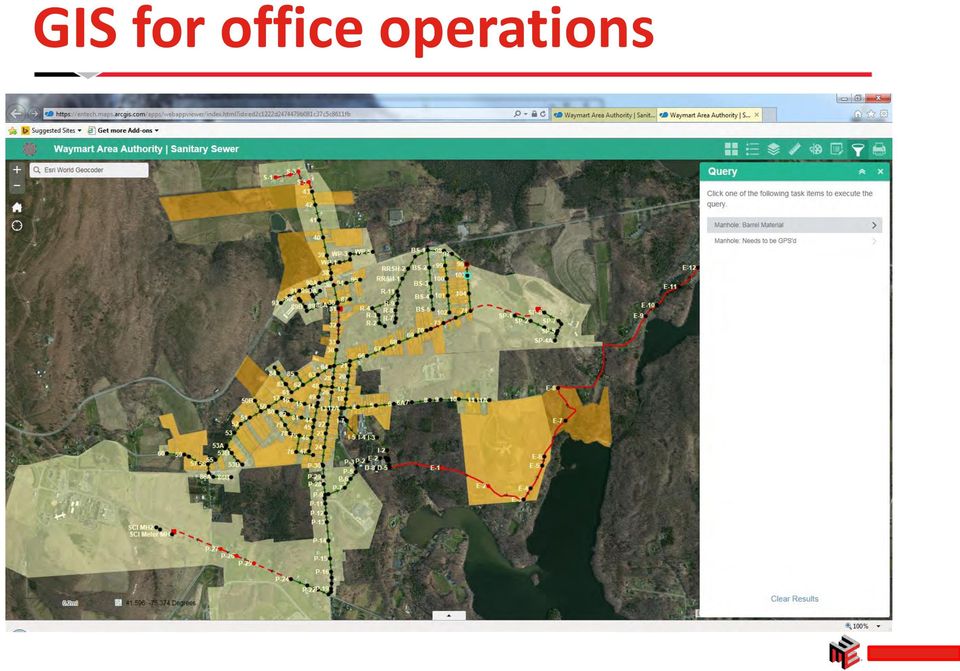
9 GIS for office operations Create / Assign Work Order Mapping Pop-ups & Data Tables Map helps you drill down to your system info Specialized Queries Office Operations Inspection Information Edit Existing GIS Data As-Built Drawings Field Photos

10 GIS for office operations

11 GIS for office operations

12 GIS for office operations

13 GIS for office operations

14 GIS for office operations

15 GIS for office operations

16 GIS for office operations
17 GIS for office operations

18 GIS for office operations

19 GIS for field operations Perform PA 1-Call Fire Hydrant Flushing Fire Hydrant Replacement Map guides your field operations Respond to Complaints Field Operations Valve Exercising Leak Detection Survey Manhole Inspection Meter Replacement

20 ESRI COLLECTOR APP INSPECTION MAP ON IPHONE

21 ZOOM INTO MAP FOR BETTER DETAIL
22 TOOLS IN MORE - BOOKMARK - LAYERS - MEASURE - BASEMAP
23 BASEMAP OPTIONS
24 STREETS BASEMAP
25 CLICK ON A FEATURE (MANHOLE, PIPE, PARCEL, ETC) HIGHLIGHTS FEATURE POP-UP AT BOTTOM
26 CLICK ON POPUP TO GET MANHOLE INFORMATION
27 SCROLL TO SEE REST OF THE INFORMATION LINKS TO DRAWINGS
28 KEEP SCROLLING FOR INSPECTION OPTIONS
29 VIEW OPENS LIST OF PREVIOUS INSPECTIONS
30 CLICK ON INSPECTION TO SEE INSPECTION DETAILS
31 NEW STARTS A NEW INSPECTION FOR THAT MANHOLE FORM-DRIVEN DATA COLLECTION
32 PICK LISTS
33 DATE PICKER
34 GENERAL TYPING
35 ATTACHMENTS TAKE A PICTURE OTHER EXISTING PICTURE OR FILE
36 TAKE A PICTURE
37 INSPECTIONS ARE UPLOADED IN REALTIME OR CAN SYNC LATER IF HAVE SPOTTY CELLULAR COVERAGE
38 REVIEW THE INSPECTION YOU JUST COMPLETED
39 SCROLL TO SEE REST OF THE INFORMATION
40 CLICK ON PHOTO TO VIEW
41 CLICK PLUS SIGN ICON TO ADD A NEW MANHOLE
42 PICK WHAT YOU WANT TO DO FROM A LIST
43 FORM-DRIVEN DATA COLLECTION
44 how would I get started? Decide what operations you want to perform. Decide whether you want to work online or offline. Pick the office and field device(s) you want to use. Step 1 Have a purpose in mind before you start. Popular tasks include manhole inspections, leak detection surveys, valve exercising, hydrant flushing, hydrant replacement, and accessing digital work orders. Step 2 Online apps allow you to use your cellular service to access your data in the cloud, and data changes are made in real time. Offline apps are good for areas with spotty cellular coverage, and allow data to be synced with your database when back at the office. Step 3 Your GIS apps should be optimized to fit on your desktop, laptop, tablet, smartphone, and/or GPS screen.
45 what happens next? Have your system data compiled into a GIS. Your GIS will be transferred to the cloud. Get trained on how to use the office and field apps. Step 4 Your GIS inventory can be built from existing CAD drawings and/or field data collection, or by using your existing GIS as a starting point. Step 5 The office and field GIS apps will include your system map, specialized map navigation tools, inspection and maintenance forms, your organization's logo, and secure access to protect your data. Step 6 Personalized field training and SOP documents will empower your staff to use your GIS from day 1.
46 example of typical costs Description ESRI ArcGIS Online Account ArcGIS Collector App Consulting services: - Format GIS data for AGOL - Append existing pix and drawings - Configure online maps Cost $2500/year for 5 licenses* Free (assumes purchase of AGOL) $0 $5000+ $0 $5000+ $ $3000 / map *may require purchase of additional AGOL credits for photo and drawing storage in the cloud
47 Thank you! Lori A. Burkert, P.G. Entech Engineering, Inc. 4 South Fourth Street P.O. Box 21 Reading, PA lburkert@entecheng.com
City of Corpus Christi. Mobile GIS Viewer. For ipad
 City of Corpus Christi Mobile GIS Viewer For ipad MIS - GIS 3/9/2012 P a g e 1 Contents Requirements... 2 Installation... 2 Using the ArcGIS Mobile App... 4 Connect to the Corpus Christi Mobile GIS Map
Using GIS to Track and Prioritize Your Assets
 Using GIS to Track and Prioritize Your Assets What is GIS?? Geographic Information System Geographic Location of an asset Information Characteristics of an asset System Software that allows connection
MobileMap and Spatial Content Management: Integrating Field Data Collection, Document Management and Enterprise GIS for Natural Resources
 MobileMap and Spatial Content Management: Integrating Field Data Collection, Document Management and Enterprise GIS for Natural Resources BRIAN GRASS MASON, BRUCE & GIRARD The Mobile Revolution Proliferation
Affordable Asset Management Workshop Making Use of the Data You Have An Owners Perspective
 Affordable Asset Management Workshop Making Use of the Data You Have An Owners Perspective Building the Foundation for an Effective Asset Management Program Scott D. Kelly, P.E. Assistant City Administrator
8/4/2014. Mobile GIS for Public Works. Ames, Iowa. Background. 2014 APWA National Congress
 Ben McConville, GIS Coordinator City of Ames Public Works Department Mobile GIS for Public Works Corey Mellies, P.E., Operations Manager City of Ames Public Works Department 2014 APWA National Congress
Manitoba Dutch Elm Disease (DED) Field Data Capture using Collector for ArcGIS and ArcGIS Online
 Field Data Capture using Collector for ArcGIS and ArcGIS Online") Manitoba Dutch Elm Disease (DED) Field Data Capture using Collector for ArcGIS and ArcGIS Online ESRI Regional User Conference Winnipeg, Manitoba April 21, 2015 1 Presentation Outline Business Problem
Manitoba Dutch Elm Disease (DED) Field Data Capture using Collector for ArcGIS and ArcGIS Online ESRI Regional User Conference Winnipeg, Manitoba April 21, 2015 1 Presentation Outline Business Problem
A Workflow for Creating and Sharing Maps
 A Workflow for Creating and Sharing Maps By Keith Mann, Esri What You Will Need Item Source ArcGIS Online for Organizations subscription ArcGIS 10.1 for Desktop (Any license level) ArcGIS Spatial Analyst
Extending Enterprise GIS Into The Field with Mobile GIS Technology
 Extending Enterprise GIS Into The Field with Mobile GIS Technology A White Paper January 10, 2014 1525 Oregon Pike Suite 202 Lancaster, PA 17601-7300 Phone (717) 399-7007 Fax (717) 399-7015 www.geographit.com
Benefits of Mobile GIS for Public Works
 Benefits of Mobile GIS for Public Works Freese and Nichols, Inc. NCAFPM 2013 Agenda General GIS Concepts Mobile GIS Overview Benefits of Mobile GIS Mobile GIS Project Examples Questions What is GIS? Geographic
Esri GIS Mobile Solutions. John Sharrard jsharrard@esri.com
 Esri GIS Mobile Solutions John Sharrard jsharrard@esri.com If I had asked people what they wanted, they would have said faster horses. Henry Ford Trend: Increase demand for location services Pew Research
How to Setup and Manage Spatial Assets with ArcGIS Online for a Mobile Workforce
 How to Setup and Manage Spatial Assets with ArcGIS Online for a Mobile Workforce W A U R I S A 2 0 1 4 Presented By Engineer Technician II Pierce County Public Works and Utilities Road Operations Division
Mobile GIS Guide. About The Author. Getting your mobile GIS project off the ground
 About The Author Matt Sheehan is a mobile GIS pioneer. He and his staff at WebMapSolutions have been providing clients with mobile GIS solutions since the earliest days of smartphones and tablets. We live
White Paper. Freeance Mobile for Cityworks
 White Paper Freeance Mobile for Cityworks Version 1.1 May 2012 Freeance Mobile for Cityworks Freeance Mobile for Cityworks 2012.1 is a mobile application for the following smartphones and tablets: iphone
Essential Mapping Apps
 Essential Mapping Apps 74% of adults use their smartphone to look at maps or other information based on their current location (of the 58% that own a smart phone) Pew Research Center Maps for Directions
E-Business Analytics Tutorial: Spatially Enabling Employees
 Spatially Enabling Commercial Organizations Presented to: Toronto User Conference Presented by: Paul Voegtle October 6 th, 2014 Seminar Overview This seminar was designated to understand; How to spatially
Making Your Mobile Workforce More Efficient
 ArcGIS for Mobile Making Your Mobile Workforce More Efficient What Is Mobile GIS? Mobile geographic information system (GIS) technology extends GIS beyond the office and allows organizations to make accurate,
Making Your Mobile Workforce More Efficient
 ArcGIS for Mobile Making Your Mobile Workforce More Efficient What Is Mobile GIS? Mobile geographic information system (GIS) technology extends GIS beyond the office and allows organizations to make accurate,
Empowering the Field Users in a Utility Enterprise. Lee Nelson PE 3-GIS
 Empowering the Field Users in a Utility Enterprise Lee Nelson PE 3-GIS Introducing 3-GIS Founded in May 2006 2010 Esri s Strategic Gold Partner Award 2011 Esri s Partners Choice Award GTI Strategic Development
Contents. The OWRB Floodplain Viewer. Creating Maps... 8. Helpful Tips... 10
 Contents QUICK START GUIDE... 2-5 Add layers...9 Search for Layers...9 COMPREHENSIVE GUIDE... 6 Navigate the map...6 Locate specific places...6 Add layer from file...9 Add layer from web...9 Display pop-up
Using Mobile GIS Technology Tools to Support Asset Management and System Operations
 Using Mobile GIS Technology Tools to Support Asset Management and System Operations Andrew Baranowski GISP, CDM Smith June 08, 2015 SFLUC 2015 Boca Raton, SFLUC FL Presentation 2015 Boca Raton, FL We are
Mobile Solutions in ArcGIS. Justin Fan
 Mobile Solutions in ArcGIS Justin Fan Agenda Introducing Mobile GIS Esri Mobile GIS solutions Selecting the right Mobile GIS solution Resources Q&A Introducing Mobile GIS What is Mobile GIS? Extends the
ESRI Mobile GIS Solutions Overview. Shane Clarke ESRI
 ESRI Mobile GIS Solutions Overview Shane Clarke ESRI Agenda Overview of mobile GIS ESRI mobile GIS Solutions Selecting a mobile GIS solution Q & A 2 Mobile GIS Overview 3 What is mobile GIS? Extension
Halifax Water Hydrant and Catchbasin Interactive Mapping USER GUIDE. Halifax Water Hydrant & Catchbasin Interactive Mapping USER GUIDE Page 1
 Halifax Water Hydrant and Catchbasin Interactive Mapping USER GUIDE Halifax Water Hydrant & Catchbasin Interactive Mapping USER GUIDE Page 1 Navigation Tools These tools may be used to maneuver your way
Embracing ArcGIS for Local Government. Robert Parsons Delaware County, Ohio Auditor s Office Steve Koenig Bruce Harris & Associates
 Embracing ArcGIS for Local Government Robert Parsons Delaware County, Ohio Auditor s Office Steve Koenig Bruce Harris & Associates Background Project began in April 2013 At that time ArcIMS 9.2 was the
{ { { Meeting Date 08/03/10. City of Largo Agenda Item 24. Leland Dicus, P.E., City Engineer
 City of Largo Agenda Item 24 Form Revision Date: 10/19/09: Meeting Date 08/03/10 Presenter: Leland Dicus, P.E., City Engineer Department: CD Community Development TITLE: GIS PROGRAM UPDATE The implementation
Quick Start Guide to. ArcGISSM. Online
 Quick Start Guide to ArcGISSM Online ArcGIS Online Quick Start Guide ArcGIS SM Online is a cloud-based mapping platform for organizations. Users get access to dynamic, authoritative content to create,
Cloud Nine: Developing an Entirely Cloud Based GIS, Asset Management and Work Order System
 Cloud Nine: Developing an Entirely Cloud Based GIS, Asset Management and Work Order System Corrie Bondar 1*, Mark Valentino 2 1 Freese and Nichols, Inc., Raleigh, North Carolina 2 Freese and Nichols, Inc.,
How To Improve Gis Data Quality
 An Esri White Paper July 2011 GIS Data Quality Best Practices for Water, Wastewater, and Stormwater Utilities Esri, 380 New York St., Redlands, CA 92373-8100 USA TEL 909-793-2853 FAX 909-793-5953 E-MAIL
Portal for ArcGIS. Satish Sankaran Robert Kircher
 Portal for ArcGIS Satish Sankaran Robert Kircher ArcGIS A Complete GIS Data Management Planning & Analysis Field Mobility Operational Awareness Constituent Engagement End to End Integration Collect, Organize,
ArcGIS 10.1 Web Apps and APIs. John Hasthorpe & Kai Hübner
 ArcGIS 10.1 Web Apps and APIs John Hasthorpe & Kai Hübner Overview Options for leveraging ArcGIS Server using Esri s Web APIs Alternatives to the Web ADF application builder (Gone in 10.1) When and how
RESCO MOBILE CRM USER GUIDE. Access your CRM data on any mobile platform ipad, iphone, Android, Windows Phone or Win XP/Vista/7/8
 RESCO MOBILE CRM USER GUIDE Access your CRM data on any mobile platform ipad, iphone, Android, Windows Phone or Win XP/Vista/7/8 Contents Synchronization... 1 1.1. How to synchronize your device... 1 1.2.
Note: Hands On workshops are Bring Your Own Laptop (BYOL), unless otherwise noted. Some workshops are Bring Your Own Mobile Device(BYOD).
, unless otherwise noted. Some workshops are Bring Your Own Mobile Device(BYOD).") 2015 MN GIS/LIS Consortium Pre Conference Workshops The Minnesota GIS/LIS Consortium is pleased to offer a diverse list of workshops on Wednesday, October 7th, 2015 at the DECC, Duluth, Minnesota Charting
2015 MN GIS/LIS Consortium Pre Conference Workshops The Minnesota GIS/LIS Consortium is pleased to offer a diverse list of workshops on Wednesday, October 7th, 2015 at the DECC, Duluth, Minnesota Charting
Create and share a map with GIScloud.com
 Create and share a map with GIScloud.com GIS Cloud is a web based Geographic Information System powered by Cloud Computing and with the full power of desktop GIS. It allows users to create and access your
RESCO MOBILE CRM QUICK GUIDE. for MS Dynamics CRM. ios (ipad & iphone) Android phones & tablets
 Android phones & tablets") RESCO MOBILE CRM for MS Dynamics CRM QUICK GUIDE ios (ipad & iphone) Android phones & tablets Windows Phone 7 & 8, Windows XP/Vista/7/8.1 and RT/Surface, Windows Mobile Synchronize Synchronize your mobile
RESCO MOBILE CRM for MS Dynamics CRM QUICK GUIDE ios (ipad & iphone) Android phones & tablets Windows Phone 7 & 8, Windows XP/Vista/7/8.1 and RT/Surface, Windows Mobile Synchronize Synchronize your mobile
How to use PGS: Basic Services Provision Map App
 How to use PGS: Basic Services Provision Map App The PGS: Basic Services Provision Map App The main features of the PGP Basic Services web application includes: Navigation Tools Map Tools Main Map Links
City of Portsmouth Portsmouth, New Hampshire Public Works Department RFP #37-15 REQUEST FOR PROPOSAL
 City of Portsmouth Portsmouth, New Hampshire Public Works Department RFP #37-15 REQUEST FOR PROPOSAL ENGINEERING CONSULTING SERVICES WATER SYSTEM ASSET MANAGEMENT PROGRAM INVITATION Sealed Proposals, plainly
ArcGIS Viewer for Silverlight An Introduction
 Esri International User Conference San Diego, California Technical Workshops July 26, 2012 ArcGIS Viewer for Silverlight An Introduction Rich Zwaap Agenda Background Product overview Getting started and
Mobile GIS Technology for Efficient Field Data Collection BRIAN GRASS MASON, BRUCE & GIRARD
 Mobile GIS Technology for Efficient Field Data Collection BRIAN GRASS MASON, BRUCE & GIRARD Outline An overview of hardware options Case Study: Sensitive Species and Noxious Weeds Mapping Our Strategy:
Build an ArcGIS Online Application
 Build an ArcGIS Online Application Sign into ArcGIS Online for Maryland 1. Open a web browser 2. Go to URL http://maryland.maps.arcgis.com/ 3. Click Sign In in the upper right corner of the web page 4.
Personal Cloud. Support Guide for Windows Mobile Devices
 Personal Cloud Support Guide for Windows Mobile Devices Storing and sharing your content 2 Getting started 2 How to use the application 2 Managing your content 2 Adding content manually 2 Viewing statistics
Taking Control of your System and Planning Your Future: Real Time Monitoring
 Advances in GIS Technology Taking Control of your System and Planning Your Future: Real Time Monitoring November 11, 2015 Topics Real-Time Monitoring Capabilities Quick Demo How do we improve uptime, increase
Bridges & Culverts Condition by Quantity
 3.4.3 What condition is it in? Approximately 93% of the municipality s bridge structures are in good to excellent condition, with the remaining 7% in fair condition. As a result, the municipality received
Step 1 Preparation and Planning
 Its daunting starting any GIS Web or Mobile project. Where does one begin? This 3 step guide should help you get past your project inertia and start things moving rapidly forward. Step 1 Preparation and
Kodiak Island Borough GIS Online Tools
 Kodiak Island Borough GIS Online Tools The Kodiak Island Borough website is located at http://www.kodiakak.us/ You can access the GIS resources by clicking on the MAP CENTER icon in the middle of the page,
Using ArcGIS for ios with Data on ArcGIS Online
 Using ArcGIS for ios with Data on ArcGIS Online Article ID : TT100038 Software : ArcGIS for ios, ArcGIS.com Platform : Windows XP, Windows Vista, Windows 7 Date : 1 st July, 2011 Introduction This Smart
GIS Applications for Regulatory Compliance
 4 GIS Applications for Regulatory Compliance Uzair (Sam) M. Shamsi Many cities in the world especially in the United States and Canada are dealing with regulatory enforcement actions for sewer overflows,
ArcGISSM. Online. The Mapping Platform for Your Organization
 ArcGISSM Online The Mapping Platform for Your Organization ArcGIS Online is a cloud-based platform for making and sharing maps, apps, and other geographic data and content. Knowledge Workers Policy Makers
Egnyte App for Android Quick Start Guide
 Egnyte App for Android Quick Start Guide Introduction Welcome to the Quick Start Guide for the Egnyte App for Android. This guide will explain how to: Access files. Download content for offline access.
3M Cloud Library Reading Apps
 M Cloud Library Reading Apps User's Guide This manual provides information on using the M Cloud Library reading apps, which include apps for the iphone, ipad, Android tablets and phones, and the PC. M,
3. GENERALI MOBILE APPLICATION CONTENT. 3 P a g e
 User Manual Generali Mobile application iphone и Android 1. MOBILE APPLICATION INSTALLMENT Generali Mobile application can be used after installation from the application markets Play Store (Android) and
ArcGIS Online Training for Program Work Teams - Part 2: Creating Basic Story Maps -
 ArcGIS Online Training for Program Work Teams - Part 2: Creating Basic Story Maps - Steve Smith, Cornell University Neil Curri, Cornell Cooperative Ext. Dutchess County Sean Carroll, Cornell Cooperative
Implementing a Mobile GIS. Tom Brenneman Esri
 Implementing a Mobile GIS Tom Brenneman Esri Agenda Mobile GIS Overview ESRI Mobile GIS Solutions - ArcPad - ArcGIS Mobile - ArcGIS for ios Select a Mobile GIS Solution Q&A Mobile GIS Overview ArcGIS 10
AUT OneDrive for Business. Instructions for Using OneDrive on Windows Platform
 AUT OneDrive for Business Instructions for Using OneDrive on Windows Platform Contents 1 What s OneDrive for Business?... 3 2 Storing Files... 5 1.1 Saving and Opening files from your Office applications...
Creating Web and Mobile Maps Using ArcGIS Online. SCO Technical Paper
 Creating Web and Mobile Maps Using ArcGIS Online SCO Technical Paper Version History Version Date Notes Author/Contact 1.0 February, 2012 Initial document created. John J Czaplewski Copyright 2012 The
ArcGIS Pro. James Tedrick, Esri
 ArcGIS Pro James Tedrick, Esri What you already know Why ArcGIS PRO? Vision The next generation ArcGIS desktop application for the GIS community who need a clean and comprehensive user experience which
KAREN E. RUSHING. Clerk of the Circuit Court and County Comptroller. Audit Services. Karen E. Rushing
 KAREN E. RUSHING Clerk of the Circuit Court and County Comptroller AUDIT OF Sarasota County s Computerized Maintenance Management System (Maximo) Audit Services Karen E. Rushing Clerk of the Circuit Court
Anchor End-User Guide
 Table of Contents How to Access Your Account How to Upload Files How to Download the Desktop Sync Folder Sync Folder How to Share a File 3 rd Party Share from Web UI 3 rd Party Share from Sync Folder Team-Share
A Winning Combination
 GITA 2011 Work Management and Mobile GIS Technology A Winning Combination Dave DiSera Vice President IT Practice Director & CTO Brian Schrantz Principal Consultant Today s Presentation In Ten Parts 1.
Esri Maps for Salesforce and Microsoft Dynamics CRM
 Esri Maps for Salesforce and Microsoft Dynamics CRM Daniel Lee, Lucy Guerra Esri UC 2014 Technical Workshop Agenda CRM and Esri Esri Maps for Demos Road Ahead Esri UC 2014 Technical Workshop Esri Maps
Building Applications with ArcGIS Runtime SDK for ios Part II. Eric Ito and Scott Sirowy
 Building Applications with ArcGIS Runtime SDK for ios Part II Eric Ito and Scott Sirowy Building Applications with ArcGIS Runtime SDK for ios Part II Eric Ito and Scott Sirowy 2011 Dev Summit Dodgeball
ArcGIS Mobile Application User s Guide
 ArcGIS Mobile Application User s Guide 1 Contents Chapter 1 Chapter 2 Chapter 3 Chapter 4 2 5 5 6 7 7 8 8 11 12 14 15 19 21 22 23 37 38 ArcGIS Mobile User Interface Essentials Title Bar Menu Bar Hardware
Spike Tech Tip: How to use your online, cloud-based tools for Spike
 Spike Tech Tip: How to use your online, cloud-based tools for Spike September 30, 2015 Tech Tip: How to use your online, cloud-based tools for Spike ikegps introduced a beta version of its cloud-based
DeKalb County, Georgia Evolution of Municipal Wastewater Asset Management Program. From Paper to CAD to ArcGIS and Beyond
 DeKalb County, Georgia Evolution of Municipal Wastewater Asset Management Program From Paper to CAD to ArcGIS and Beyond Darren S. Eastall Sean Kilpatrick DeKalb County, Georgia Brown and Caldwell Overview
Asset Tracking and Traceability Oklahoma Gas Association. Mike Zandaroski August 28, 2013
 Asset Tracking and Traceability Oklahoma Gas Association Mike Zandaroski August 28, 2013 Why is it important for an operator to be concerned about traceability and tracking of assets? CenterPoint s rational
Organically Growing an Asset Management System in the City of Novi, Michigan
 Organically Growing an Asset Management System in the City of Novi, Michigan IMAGIN Conference 2015 Traverse City, Michigan City of Novi, Michigan - Location 2 1 City of Novi, Michigan Vital Statistics
Employing GIS, Cloud, and Mobile Technologies to Support Asset Management and System Management
 NAME OF MEETING: NC AWWA- WEA Annual Conference 2013 AUTHORS: Jayson Brennen, GISP SESSION/PAPER NO.: Policy & Management Session Tuesday 11/12/2013, 1:45PM PAPER FORMAT: MS Word ABSTRACT FORMAT: MS Word
Android Tablet GIS Solution Transforms Well Inspection for Bucks County Health Department
 Android Tablet GIS Solution Transforms Well Inspection for Bucks County Health Department A Case Study Problem Statement The Bureau of Environmental Health (BEH) within the Bucks County Health Department
Storytelling with Maps: Workflows and Best Practices
 Storytelling with Maps: Workflows and Best Practices Introduction What is a story map? Story maps are interactive maps combined with text and other content to tell a story about the world. Typically story
Conservation Workshop ArcGIS Explorer
 Conservation Workshop ArcGIS Explorer Bern Szukalski bszukalski@esri.com Topics for this session Introduction Overview of features Using ArcGIS Explorer effectively New features & capabilities Customization
White Paper. www.geodecisions.com
 White Paper www.geodecisions.com A Geo Spatial Total Asset Management System (TAMS) To Improve Asset Management Decision Making Fall 2013 Abstract This paper describes a Geospatial Total Asset Management
ArcGIS Online Instructions Create a Map Make a Slide Presentation Upload Field Investigation Data
 ArcGIS Online Instructions Create a Map Make a Slide Presentation Upload Field Investigation Data Overview ArcGIS Online has made creating maps very easy. You will learn how to watch a slide presentation
Best Practice Guide for constructing a study area in studentcentral which is designed for friendly viewing in Blackboard Mobile Learn
 Best Practice Guide for constructing a study area in studentcentral which is designed for friendly viewing in Blackboard Mobile Learn Blackboard state that Blackboard Mobile Learn was designed to provide
Kingdom Of Bahrain Ministry of Works. Enterprise Asset Management System A Geocentric Approach. Presented By Hisham Y.
 Kingdom Of Bahrain Ministry of Works Enterprise Asset Management System A Geocentric Approach Presented By Hisham Y. Sater April 2012 Ministry Of Works Bahrain MOW The construction arm of the Kingdom of
Studying Topography, Orographic Rainfall, and Ecosystems (STORE)
") Studying Topography, Orographic Rainfall, and Ecosystems (STORE) Introduction Basic Lesson 2: Using ArcGIS Explorer to Analyze the Connection between Topography and Rainfall This lesson introduces Geographical
Studying Topography, Orographic Rainfall, and Ecosystems (STORE) Introduction Basic Lesson 2: Using ArcGIS Explorer to Analyze the Connection between Topography and Rainfall This lesson introduces Geographical
Introduction to Web AppBuilder for ArcGIS: JavaScript Apps Made Easy
 Introduction to Web AppBuilder for ArcGIS: JavaScript Apps Made Easy OKSCAUG Pamela Kersh September 22, 2015 The ArcGIS Platform enables Web GIS Enabling GIS Everywhere Desktop Web Device Simple Integrated
Qsync Install Qsync utility Login the NAS The address is 192.168.1.210:8080 bfsteelinc.info:8080
 Qsync Qsync is a cloud based file synchronization service empowered by QNAP Turbo NAS. Simply add files to your local Qsync folder, and they will be available on your Turbo NAS and all its connected devices.
Getting Started With Mortgage MarketSmart
 Getting Started With Mortgage MarketSmart We are excited that you are using Mortgage MarketSmart and hope that you will enjoy being one of its first users. This Getting Started guide is a work in progress,
Activity: Using ArcGIS Explorer
 Activity: Using ArcGIS Explorer Requirements You must have ArcGIS Explorer for this activity. Preparation: Download ArcGIS Explorer. The link below will bring you to the ESRI ArcGIS Explorer download page.
University of Arizona THE CAMPUS SPATIAL DATA INITIATIVE
 University of Arizona THE CAMPUS SPATIAL DATA INITIATIVE Presentation Review 1. Background on Campus Mapping and Spatial Data 2. The Campus Spatial Data Users Research / Teaching / Outreach Administration
How To Manage A Hydrant
 USING MOBILE GIS TECHNOLOGY TO GATHER COMPREHENSIVE ASSET CONDITION DATA OF BRISBANE & IPSWICH S FIRE HYDRANT NETWORK Daniel Faccio 1, Malcolm Potts 2 1. Queensland Urban Utilities, Brisbane, OLD 2. Thiess,
Prepare Data ArcMap Open Trees.mpk Chrome ArcGIS Online New Map Chrome Esri Blogs Chrome Local Government Resources Reflector Phone Connected
 Prepare Data ArcMap Open Trees.mpk Chrome ArcGIS Online New Map Chrome Esri Blogs Chrome Local Government Resources Reflector Phone Connected Kate Firefox http://doc.arcgis.com/en/operations dashboard/
Open Data. Open Data. Share and map your data with ArcGIS. technology.
 Open Data Share and map your data with ArcGIS Open Data technology. Publishing data as map services is one of the most valuable ways to communicate and collaborate. Maps enable an immediate understanding
Managing Assets and the Important Role of GIS and GPS. Arthur Astarita, Water Resource Specialist
 Managing Assets and the Important Role of GIS and GPS Arthur Astarita, Water Resource Specialist RCAP Network Agenda Quick review of GPS and GIS Asset Management (What? & Why?) Concepts Inventory Attributes
Texas Wildfire Risk Assessment Portal (TxWRAP) User Manual. Texas A&M Forest Service
 User Manual. Texas A&M Forest Service") Texas Wildfire Risk Assessment Portal (TxWRAP) User Manual Texas A&M Forest Service October 2012 Table of Contents 1 ABOUT TXWRAP... 7 1.1 ACCESSING TXWRAP... 7 1.2 GETTING SUPPORT... 8 Documentation...
Texas Wildfire Risk Assessment Portal (TxWRAP) User Manual Texas A&M Forest Service October 2012 Table of Contents 1 ABOUT TXWRAP... 7 1.1 ACCESSING TXWRAP... 7 1.2 GETTING SUPPORT... 8 Documentation...
Outlook Web App (Online)... 3 Outlook 2013 (Desktop)... 16 Apple Mail Mobile Devices... 33 Android... 33 iphone... 40
... 3 Outlook 2013 (Desktop)... 16 Apple Mail Mobile Devices... 33 Android... 33 iphone... 40") Webmail Tutorials Page 2 Table of Contents Outlook Web App (Online)... 3 How do I send an email?... 3 How do I create rules to manage my email?... 3 How do I forward email to my personal account?... 4
Webmail Tutorials Page 2 Table of Contents Outlook Web App (Online)... 3 How do I send an email?... 3 How do I create rules to manage my email?... 3 How do I forward email to my personal account?... 4
Introduction... 2. Download and Install Mobile Application... 2. About Logging In... 4. Springboard... 4. Navigation... 6. List Pages...
 Contents Introduction... 2 Download and Install Mobile Application... 2 About Logging In... 4 Springboard... 4 Navigation... 6 List Pages... 6 Example: Edit Contact... 7 View Pages... 12 Example: Companies...
Development of an Integrated Data Management System (Web based) City of Chattanooga
 City of Chattanooga") Development of an Integrated Data Management System (Web based) for NDPES Compliance and BMP Tracking (MS4 Activities) City of Chattanooga SESWA 2011 Annual Conference October 3-5, 2011 Asheville Renaissance
Development of an Integrated Data Management System (Web based) for NDPES Compliance and BMP Tracking (MS4 Activities) City of Chattanooga SESWA 2011 Annual Conference October 3-5, 2011 Asheville Renaissance
Intro to Web App Builder. Mark Scott, Solutions Engineer, Esri County Government Team mscott@esri.com
 Intro to Web App Builder Mark Scott, Solutions Engineer, Esri County Government Team mscott@esri.com The ArcGIS Platform enables Web GIS Enabling GIS Everywhere Desktop Web Device Simple Integrated Open
Well there is a way. We don t have an elegant user experience for this right now, but if you are a GIS geek you can do it!
 How to Update Your Hosted Feature Service Schemas in ArcGIS Online When considering the flow of data between the office and the field one of the biggest challenges you face is how to manage change. Though
UNGIWG 14. Steve Maddison, George Davis, Latitude Geographics Friday, May 16 th 2014
 UNGIWG 14 Steve Maddison, George Davis, Latitude Geographics Friday, May 16 th 2014 GIS Challenges Today Spatial Application Infrastructure (SAI) The Geocortex Approach 2 1 Geocortex Essentials Web-based
ReadyNAS Remote. User Manual. June 2013 202-11078-03. 350 East Plumeria Drive San Jose, CA 95134 USA
 User Manual June 2013 202-11078-03 350 East Plumeria Drive San Jose, CA 95134 USA Support Thank you for selecting this NETGEAR product. After installing your device, locate the serial number on the label
Using e-books on mobile devices
 Using e-books on mobile devices E-books on EBL, EBSCOhost and Ebrary can be downloaded for use on desktop PCs, laptops and tablets. This requires Adobe Digital Editions or, for tablets, Bluefire Reader.
Geographic Information System Tools for Management of US DOE Sites 14125
 Geographic Information System Tools for Management of US DOE Sites 14125 John Montgomery*, Cliff Carpenter*, Leonard Turton**, Steve Pawel** *US DOE, Office of Legacy Management **S.M. Stoller Corporation
Off The Shelf Approach to ArcGIS Server & The Dashboard Approach to Gaining Insight to ArcGIS Server
 Off The Shelf Approach to ArcGIS Server & The Dashboard Approach to Gaining Insight to ArcGIS Server Robert Lenarcic Latitude Geographics rlenarcic@latitudegeo.co AGENDA Out of the box ArcGIS Server web-mapping
Quick Start Guide Using OneDisk with the Tappin Service
 Quick Start Guide Using OneDisk with the Tappin Service Copyright 2013, Tappin, Inc. All rights reserved. Tappin and the Tappin logo are trademarks of Tappin, Inc. All other trademarks are the property
The Redwood City Public Works Services (PWS) Department is comprised of four operating divisions:
 Department is comprised of four operating divisions:") City of Redwood City, Public Works Services (PWS) Work Process Needs Assessment By: Russell Narahara, Management Analyst II The purpose of this document is to provide an overview of how field work is currently
City of Redwood City, Public Works Services (PWS) Work Process Needs Assessment By: Russell Narahara, Management Analyst II The purpose of this document is to provide an overview of how field work is currently
HELCOM Data and Map Service. User Manual
 HELCOM Data and Map Service User Manual Version 2.2 - February 2015 1 Table of contents 1. General Information... 3 1.1 Background... 3 1.2 Technical requirements... 3 1.3 Contact... 3 2. Accessing HELCOM
SJRWMD Cloud-Based Email Quick-Start Guide
 SJRWMD Cloud-Based Email Quick-Start Guide Your email account is now in the Microsoft cloud, also known as Office 365. This change from onpremise email provisioning to the cloud allows the agency to provide
An Introduction to Box.com
 An Introduction to Box.com Box is an online file sharing and cloud content management service and it provides features such as: Security controls Space Mobility Online collaboration Mobile access Version
Communicating Our World:
 Communicating Our World: Utilizing ArcGIS Online as a Communication Tool for the Puyallup School District Brian Devereux Planning Director Puyallup School District 2014 Washington GIS Conference Presentation