Planning Policy and Guidance on Flooding and Coastal Erosion
|
|
|
- Theresa Gilmore
- 10 years ago
- Views:
Transcription
1 Planning Policy and Guidance on Flooding and Coastal Erosion James Hooker (MRTPI) Senior Planning Manager Welsh Government RTPI Cymru - Water and Flooding Seminar Tuesday 20 th November 2012

2
3 Overview Planning Policy Wales TAN14: Coast TAN15: Flood Risk DAM Maps Zone C2 Zone C1 - Justification Test Assessing Flood Consequence Flooding Consequences Role of EAW & LPA Responsibility Notification Direction A bit late?

4 Planning Policy Wales Chapter Five Heritage & Coast [Coastal] areas subject to constraints or considered unsuitable for development may include those where conservation or enhancement of the natural and historic environment requires development to be limited, where visual intrusion will need carefully to be considered and where there may be risks of erosion, flooding or land instability. options for coastal defence may include a policy of managed set back

5 Shoreline management plans will establish long-term local policy frameworks for the management of coastal risk. The priorities contained within them should influence and inform the preparation of development plans. Before major developments are permitted it will be essential to demonstrate that a coastal location is required. Where development is considered to satisfy this test it should be designed so as to be resilient to the effects of climate change over its lifetime.

6 New coastal development should not generally be permitted in areas which would need expensive engineering works, either to protect developments on land subject to erosion by the sea or to defend land which might be inundated by the sea. There is also the need to consider the possibility of such works causing a transfer of risks to other areas, bearing in mind also that erosion and the risk of inundation are likely to be exacerbated by climate change.

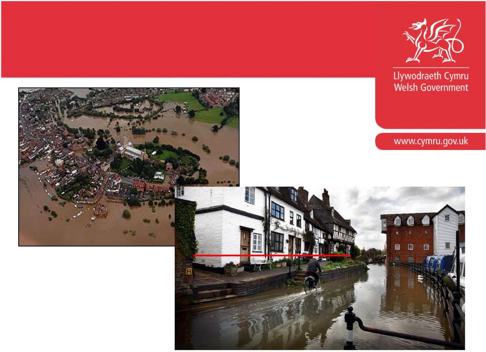
7 Chapter 13 Minimising & Managing Environmental Risks How much water? June 2012 panoramio.com EA River Gauge River Leri nr Dolybont

8 Flood Risk Flood risk, whether inland or from the sea, is a material consideration in land use planning. Local planning authorities should recognise that it will be inappropriate to locate certain types of development such as schools, hospitals, residential development and emergency services within some areas defined as being of high flood hazard. In such areas, local planning authorities should ensure that only appropriate land allocations are made during the preparation of development plans.

9 Government resources for flood and coastal defence projects are directed at protecting existing developments and are not available to provide defences in anticipation of future development. Panarimo.com

10 A sustainable approach to flooding will therefore involve the avoidance of development in flood hazard areas and, where possible or practical, the encouragement of managed retreat, the creation of wash-lands and flood plain restoration.

11 TAN14 Coastal Planning It is for each LPA to consider and define the most appropriate coastal zone in its area. Proposals for development need to consider the potential need for remedial and defence works and the likely effects on physical & biological processes along the coast. Development plan policies should not provide for development on the coast which does not require a coastal location.

12 TAN14 - continued Policies will specifically be needed to control or restrict development in: low lying coastal areas; on land close to eroding cliffs or other eroding coastline; and on land subject to instability. Onus rests on the developer to provide sufficient and appropriate information to demonstrate that proposed sites can be safely developed without significant adverse effects.

13 TAN15: Development & Flood Risk Development Advice Maps (September 2009) Based on EA s flood maps, and identify the 0.1% extreme flood risk area. 0.1% flood outline is divided into two zones: C1 areas of the floodplain which are developed and served by significant infrastructure, including flood defences C2 areas of the floodplain without significant flood defence infrastructure

14 Online Development Advice Maps DAM maps are now available online at

15 TAN15 Zone C2 Figure 1 (page 5) identifies that only less vulnerable development should be considered in Zone C2. Section 6 identifies that In Zone C the tests outlined in sections 6 & 7 will be applied, recognising, however that highly vulnerable development and Emergency Services in Zone C2 should not be permitted.

16 Section 9 (Summary of Policy Requirements) states in respect to Zone C2: Developer 3 Developer 1 The flooding consequences associated with Emergency Services and highly vulnerable development are not considered to be Developer 2 acceptable. Plan allocations should not be made for such development and planning applications not proposed.

17 TAN15 Zone C1 Section 6 Justification Test i) Local authority regeneration initiative or stategy [development plan] required to sustain an existing settlement, or, ii) contribute to key employment objectives supported by the local authority, and other key partners to sustain an existing settlement or region, and, iii) concurs with the aims of PPW and meets the definition of previously developed land; and,
 concurs with the aims of PPW and meets the definition of previously developed")
18 iv) Potential consequences of a flooding event for the particular type of development have been considered, and in terms of the criteria contained in sections 5 and 7 and appendix 1 found to be acceptable.

19 TAN15 Appendix 1 Assessing Flooding Consequences A1.12 A site should only be considered for development if the following conditions can be satisfied: -Flood defences shown to be structurally adequate under extreme overtopping conditions - Cost of future maintenance for all new/approved mitigation measures must be accepted by the developer and agreed with the Environment Agency - Developer must ensure that future occupiers are aware of flooding risks and consequences

20 - Effective flood warnings are provided at the site. - Escape/Evacuation routes are shown be the developer to be operational under all conditions.

21 - Development is designed to minimise structural damage during a flood event, and is flood proofed to enable it to be returned to its prime use quickly in the aftermath of the flood.
22 -No flooding elsewhere Table A1:14 Threshold for which development should be designed to be flood free. Table A1:15 Thresholds for residual risk in extreme 0.1% flood event.
23 Role of EAW/ LPA responsibility EAW will provide technical advice on the content of a flood consequence assessment. EAW may object where from a technical perspective there is an unacceptable risk in flood risk management terms. EAW will not comment on the acceptability of emergency access and egress. Response letters clearly state: Your Authority, in liaison with other appropriate bodies, should ensure that you are satisfied with the identified access/egress routes and their acceptability for emergency access purposes.
24 LPA is therefore responsible for determining that escape and evacuation routes are shown by the developer to be operational under all conditions.
25 Notification Direction New requirement for local planning authorities to refer applications for emergency services or highly vulnerable development, where the whole of the land where the development is proposed to be located, is within flood zone C2, shown on the development advice map (DAM). In cases consisting of residential development, the threshold for requiring notification is set at 10 or more dwellings, including flats.
26 Thank you Introductory Briefing: Transport James Hooker
NEW DEVELOPMENT AND EMERGENCY FLOOD PLANS
 23 NEW DEVELOPMENT AND EMERGENCY FLOOD PLANS Turn page Northamptonshire Flood Toolkit This guidance has been developed to support applicants and developers who are required or encouraged to produce and
FLOOD RISK RECENT TRENDS AND POLICY RESPONSES
 FLOOD RISK RECENT TRENDS AND POLICY RESPONSES DEVELOPING WESTMINSTER S LOCAL PLAN Booklet No. 2 LDF Consultation - CMP Revision November 2013 INTRODUCTION CLLR ROBERT DAVIS Westminster is at risk of flooding
Environment Agency 2014 All rights reserved. This document may be reproduced with prior permission of the Environment Agency.
 Flood and coastal erosion risk management Long-term investment scenarios (LTIS) 2014 We are the Environment Agency. We protect and improve the environment and make it a better place for people and wildlife.
PLANNING APPLICATION: 12/00056/APP
 PLANNING APPLICATION: 12/00056/APP In the event that a recommendation on this planning application is overturned the Committee is reminded of the advice contained on the front page of the agenda for Reports
Guideline: A risk assessment approach to development assessment in coastal hazard areas
 Guideline: A risk assessment approach to development assessment in coastal hazard areas Prepared by: Environment Planning, Department of Environment and Heritage Protection State of Queensland, 2013. The
Flood Risk & Surface Water Management. Page 1 of 20
 Page 1 of 20 Flood Risk & Surface Water Management Flood Risk & Surface Water Management and the Planning Process Introduction The purpose of this document is to increase awareness of the potential of
SECTION 10.0 MANAGEMENT UNIT 5: HORNSEA
 10.1 Summary Information 10.1.1 Location SECTION 10.0 MANAGEMENT UNIT 5: HORNSEA The limits of Management Unit 5, a 2.9km stretch of shoreline fronting the town of Hornsea on the Holderness coast, are
PLANNING. Planning Policy Statement 25: Development and Flood Risk Practice Guide
 PLANNING POLICY STATEMENT 25 PRACTICE GUIDE Taking flood risk into account in the planning process Planning shapes the places where people live and work and the country we live in. It plays a key role
Planning Advice Note Guidance on Producing a Flood Emergency Plan. For planning applicants and developers to accompany a planning application
 Planning Advice Note Guidance on Producing a Flood Emergency Plan For planning applicants and developers to accompany a planning application DISCLAIMER The London Borough of Richmond upon Thames, as far
Preliminary Environmental Information Report: Appendix 16.C. Flood Warning and Evacuation Plan
 Preliminary Environmental Information Report: Appendix 16.C Flood Warning and Evacuation Plan THIS PAGE IS LEFT INTENTIONALLY BLANK Page 2 of 30 Contents SUMMARY 1. INTRODUCTION... 9 1.1 Background...
11.4 Voluntary Purchase. 11.5 House Raising and Flood Proofing
 11.4 Voluntary Purchase As mentioned in Section 10 in certain high hazard areas of the floodplain, it may be impractical or uneconomic to mitigate flood hazard to existing properties at risk, or flood
DWELLING ADJACENT TO 2, FIELD LANE, MORTON, NR GAINSBOROUGH, LINCOLNSHIRE.
 FLOOD EMERGENCY PLAN FOR DWELLING ADJACENT TO 2, FIELD LANE, MORTON, NR GAINSBOROUGH, LINCOLNSHIRE. MARCH 2014 Introduction In accordance with Environment Agency advice this Flood Emergency Plan is proportionate
New Brunswick s Flood Risk Reduction Strategy. Province of New Brunswick PO 6000, Fredericton NB E3B 5H1. www.gnb.ca
 New Brunswick s Flood Risk Reduction Strategy i New Brunswick s Flood Risk Reduction Strategy Province of New Brunswick PO 6000, Fredericton NB E3B 5H1 2014 www.gnb.ca ISBN 978-1-4605-0533-5 (print edition)
Coastal Erosion Risk Mitigation Strategies applied in a Small Island Developing State: The Barbados Model
 Coastal Erosion Risk Mitigation Strategies applied in a Small Island Developing State: The Barbados Model BY Dr. Leo Brewster, Director Coastal Zone Management Unit, Barbados Presented At UNFCCC Expert
SUFFOLK COASTAL DISTRICT COUNCIL DOMESTIC FLOOD PROTECTION POLICY
 SUFFOLK COASTAL DISTRICT COUNCIL DOMESTIC FLOOD PROTECTION POLICY 1. Introduction 1.1 The Council recognises the threat to local communities from flooding following severe weather events and as a result
Planning Policy Statement 15 (PPS 15) Planning and Flood Risk
 Planning and Flood Risk") Planning Policy Statement 15 (PPS 15) Planning and Flood Risk Planning Policy Statement 15 (PPS 15) Planning and Flood Risk Planning Policy Statements (PPSs) set out the policies of the Department of the
Planning Policy Statement 15 (PPS 15) Planning and Flood Risk Planning Policy Statement 15 (PPS 15) Planning and Flood Risk Planning Policy Statements (PPSs) set out the policies of the Department of the
4.14 Netherlands. Interactive flood risk map of a part of the province of Gelderland in the Netherlands. Atlas of Flood Maps
 4.14 Netherlands The Netherlands is flood prone for about 60% of its surface. 95 so-called dike-rings protect the polders from being flooded from the North Sea, rivers or lakes. The protection level has
SUBJECT: Housing Development Proposals Outside of Local Development Plan (LDP) Development Boundaries.
 Development Boundaries.") Appendix 1 Denbighshire County Council PLANNING STRATEGY DEVELOPER GUIDANCE NOTE November 2015 SUBJECT: Housing Development Proposals Outside of Local Development Plan (LDP) Development Boundaries. Context
Appendix 1 Denbighshire County Council PLANNING STRATEGY DEVELOPER GUIDANCE NOTE November 2015 SUBJECT: Housing Development Proposals Outside of Local Development Plan (LDP) Development Boundaries. Context
Anchorage All-Hazard Mitigation Plan October 2004
 EXECUTIVE SUMMARY The Municipality of Anchorage (MOA) is vulnerable to a wide range of natural, technological, and human/societal hazards including earthquakes, avalanches, and hazardous material accidents.
FLOOD RISK STATEMENT IN SUPPORT OF THE CONNECTING HERNE BAY AREA ACTION PLAN PREFERRED OPTIONS DOCUMENT
 FLOOD RISK STATEMENT IN SUPPORT OF THE CONNECTING HERNE BAY AREA ACTION PLAN PREFERRED OPTIONS DOCUMENT Canterbury City Council January 2008 1 APPLICATION OF THE PPS25 SEQUENTIAL AND EXCEPTION TESTS 1.0
Planning for sea level rise. Assessing development in areas prone to tidal inundation from sea level rise in the Port Phillip and Westernport Region
 Planning for sea level rise Assessing development in areas prone to tidal inundation from sea level rise in the Port Phillip and Westernport Region Table of contents Introduction 1 New flood levels for
Mr & Mrs Clarke Proposed Development at The River House, Balderstone Flood Risk Assessment
 Proposed Development at The River House, Balderstone D2192-FRA-01 5 Nov 2015 PSA Design Ltd Consulting Engineers The Old Bank House 6 Berry Lane Longridge Preston PR3 3JA Tel. 01772 786066 Fax. 01772 786265
Flood Risk Assessment and Drainage Impact Assessment: Planning Guidance for Developers
 Flood Risk Assessment and Drainage Impact Assessment: Planning Guidance for Developers Development and Regeneration Services Glasgow City Council 229 George Street Glasgow G1 1QU May 2011 1. Introduction...-
Climate Change Toolkit 07 Designing for Flood Risk
 Climate Change Toolkit 07 Designing for Flood Risk About this Document This is the seventh of eight components of Climate Change Tools, a package of guidance developed by the RIBA to encourage architects
Town of Chatham Department of Community Development
 Town of Chatham Department of Community Development TOWN ANNEX 261 GEORGE RYDER ROAD 02633 CHATHAM, MA TELEPHONE (508) 945-5168 FAX (508) 945-5163 FEMA FLOOD MAP UPDATE & PROPOSED ZONING BYLAW AMENDMENT
2015 -- H 5478 S T A T E O F R H O D E I S L A N D
 LC00 01 -- H S T A T E O F R H O D E I S L A N D IN GENERAL ASSEMBLY JANUARY SESSION, A.D. 01 H O U S E R E S O L U T I O N CREATING THE RHODE ISLAND HOUSE COMMISSION ON ECONOMIC RISK DUE TO FLOODING AND
Implementing a Coastal Settlement Boundary
 Implementing a Coastal Settlement Boundary Planning Practice Note 36 AUGUST 2015 The purpose of this practice note is to provide guidance about implementing a coastal settlement in a planning scheme for
Association of State Flood Managers Annual Conference Wednesday, June 4, 2014
 Association of State Flood Managers Annual Conference Wednesday, June 4, 2014 Hillsborough County, In the Trenches Local Mitigation Eugene Henry, CFM, AICP Hazard Mitigation Manager Floodplain Administrator
The Planning System and Flood Risk Management
 20 The Planning System and Flood Risk Management Guidelines for Planning Authorities November 2009 The Planning System and Flood Risk Management Guidelines for Planning Authorities Contents PAGE Ministers
Wye and Usk Catchment Flood Management Plan. Summary Report January 2010. managing flood risk
 Wye and Usk Catchment Flood Management Plan Summary Report January 2010 managing flood risk We are Environment Agency Wales. It s our job to look after your environment and make it a better place for you,
Presentation by Michael Wade. Crown Representative for Insurance at the Cabinet Office of the UK Government. National Flood Conference Washington DC
 Presentation by Michael Wade Crown Representative for Insurance at the Cabinet Office of the UK Government National Flood Conference Washington DC May 2015 Role of the Crown Representative.. Role of the
Resolution XII.13. Wetlands and disaster risk reduction
 12 th Meeting of the Conference of the Parties to the Convention on Wetlands (Ramsar, Iran, 1971) Punta del Este, Uruguay, 1-9 June 2015 Resolution XII.13 Wetlands and disaster risk reduction 1. RECALLING
With a combination of soaking rain, flying debris, high winds, and tidal surges, Hurricanes and tropical storms can pack a powerful punch.
 With a combination of soaking rain, flying debris, high winds, and tidal surges, Hurricanes and tropical storms can pack a powerful punch. Besides causing extensive damage in coastal areas, hurricanes
ECONOMIC ANALYSIS FLOOD DAMAGE REDUCTION. Lower Carmel River Floodplain Restoration and Enhancement Project
 ECONOMIC ANALYSIS FLOOD DAMAGE REDUCTION Lower Carmel River Floodplain Restoration and Enhancement Project I. Description of the Project and its Relationship to Other Projects in the Proposal The Lower
London Borough of Merton Local Flood Risk Management Strategy
 Local Flood Risk Management Strategy Summary 2014-2020 Introduction In response to the severe flooding across large parts of England and Wales in summer 2007, the Government has recently enacted the Flood
Oregon. Climate Change Adaptation Framework
 Oregon Climate Change Adaptation Framework Oregon Environmental Quality Commission Climate Change Adaptation Framework Presentation at a glance: Purposes of the framework Participating agencies Climate
Flood Risk Management Plans
 Flood Risk Management Plans Main topics of interest and the workshop programme Jos van Alphen 26-01-2010 Content 1. Floods in Europe and related measures 2. The Floods Directive and Flood Risk Management
FLOOD RISK AND SURFACE WATER DRAINAGE ASSESSMENT HILLHOUSE RESTORATION SITE, OFF JAMESON ROAD, THORNTON CLEVELEYS ON BEHALF OF NPL ESTATES
 FLOOD RISK AND SURFACE WATER DRAINAGE ASSESSMENT HILLHOUSE RESTORATION SITE, OFF JAMESON ROAD, THORNTON CLEVELEYS ON BEHALF OF NPL ESTATES Integra Consulting Engineers Limited NS / 2543 Fountain House
chapter 9 conduct a climate change
 CONDUCT A CLIMATE RESILIENCY STUDY The following chapters recommend how to reach CRC Milestone Two, Conduct a Climate Resiliency Study. 2 MILESTONE Chapter 8: Conduct a Climate Change Vulnerability Assessment
Barre City City-wide Policy and Program Options
 Barre City (VERI Land Use Regulations Update policies allowing fill in flood hazard areas. RPC, DEC River Management, VLCT, Allowing landowners to elevate buildings using fill may help protect an individual
R enfrewshire Local Plan. Safe Environment. Page. Flooding & Sustainable Urban Drainage 163 Contaminated Land 175 Noise 177 Major-Accident Hazards 179
 R enfrewshire Local Plan Safe Environment Page Flooding & Sustainable Urban Drainage 163 Contaminated Land 175 Noise 177 Major-Accident Hazards 179 16 Flooding and Sustainable Urban Drainage OVERVIEW Flooding
Humber and the English East Coast Tuesday 26 th April 2011
 Estuarine and Coastal Sciences Association UK Local Meeting Humber and the English East Coast Tuesday 26 th April 2011 1 Coastal Change Management in the East Riding of Yorkshire Jeremy Pickles Senior
United States Postal Service Climate Change Adaptation Plan
 United States Postal Service Climate Change Adaptation Plan Version: June 29, 2012 USPS Climate Change Adaptation Plan 1. Introduction...2 2. Policy Framework...3 Vision & Goals...3 Objectives...3 Responsible
NOAA COASTAL SERVICES CENTER Strategic Plan: 2010 to 2015
 NOAA COASTAL SERVICES CENTER Strategic Plan: 2010 to 2015 N a t i o n a l O c e a n i c a n d A t m o s p h e r i c A d m i n i s t r a t i o n ( N O A A ) C o a s t a l S e r v i c e s C e n t e r March
How To Write A New Bill On Flood Management In Scotland
 Scottish Environment LINK is the forum for Scotland's voluntary environment organisations representing a broad spectrum of environmental interests with the common goal of contributing to a more environmentally
INFRASTRUCTURE, FLOOD PROTECTION AND REMEDIATION. Infrastructure Flood Protection Remediation Policies
 INFRASTRUCTURE, FLOOD PROTECTION AND REMEDIATION Infrastructure Flood Protection Remediation Policies DRAFT POOLBEG PLANNING SCHEME 196 FIGURE 9.1: UTILITIES WAYLEAVES Electricity Cables 8m Wayleave for
NYSDEC Optional Additional Language Model Local Law for Flood Damage Prevention Optional Additional Language
 NYSDEC General Comments. The contains language that complies with the floodplain management requirements of the National Flood Insurance Program (NFIP) contained in federal regulations 44 CFR 60.3 through
Strategic Flood Risk Assessment
 local development framework Strategic Flood Risk Assessment LOCAL DEVELOPMENT FRAMEWORK ROYAL BOROUGH OF KINGSTON UPON THAMES Level 1 and 2 April 2011 Contents Executive Summary 5 Part 1 - Aiding Planning
Section E2 Coastal Engineering: Reconstruction Management and Mitigation
 271 Section E2 Coastal Engineering: Reconstruction Management and Mitigation 272 Objectives To familiarize the assessor with the process that should be followed in organizing any reconstruction efforts.
Interim Technical Guidelines for the Development of Environmental Management Plans for Underground Infrastructure Revised - July 2013.
 Interim Technical Guidelines for the Development of Environmental Management Plans for Underground Infrastructure Revised - July 2013 Rationale Underground infrastructure may be at risk from valley, streambank
Strategic Flood Risk Assessment Update 2015
 Strategic Flood Risk Assessment Update 2015 On behalf of Contents Glossary... iv Executive Summary... 1 1 Introduction... 4 1.1 Overview... 4 1.2 Future Development in Lewisham Borough... 5 2 SFRA Approach...
A. Flood Management in Nevada
 Nevada Division of Water Planning A. Flood Management in Nevada Introduction Flooding has been a concern for Nevada communities since the first settlers moved to the territory in the mid-1800 s. Fourteen
Disaster Risk Reduction and Building Resilience to Climate Change Impacts
 Disaster Risk Reduction and Building Resilience to Climate Change Impacts Luna Abu-Swaireh ([email protected]) May 2015 United Nations Office for Disaster Risk Reduction (UNISDR) Droughts Floods Storms
US Army Corps of Engineers Authorities and Programs
 US Army Corps of Engineers Authorities and Programs Section 206; Flood Plain Management Services Program Section 22; Planning assistance to States General Investigations (large-scale flood risk reduction)
Chapter 2 Spatial Portrait
 15 November 2013 Dear Julie Fylde Local Plan to 2030 Part 1 Preferred Options Thank you for the opportunity to meet with you on 9 October in respect of the above mentioned document. As discussed at the
Objective 4: Enhanced community education, flood awareness and preparedness
 Objective 4: Enhanced community education, flood awareness and preparedness Understanding the extent and full impacts of flooding is essential for planning for potential future pressures on the drainage
OURIMBAH FLOOD RESPONSE PLAN
 OURIMBAH FLOOD RESPONSE PLAN February 2014 2 EMERGENCY CONTACT DETAILS Security Services for all Emergencies (24 Hours) Ourimbah 4348 4222 If not able to be reached please call Newcastle on Newcastle 4921
ITEM 8(a) MANAGEMENT COMMITTTE 2 JUNE 2015
 MANAGEMENT COMMITTTE 2 JUNE 2015") ITEM 8(a) MANAGEMENT COMMITTTE 2 JUNE 2015 APPENDIX Report from Harbour Management Board -1April 2015 Weymouth Harbour Walls Remediation Work Harbour Management Board 1 April 2015 Weymouth Harbour Walls
ITEM 8(a) MANAGEMENT COMMITTTE 2 JUNE 2015 APPENDIX Report from Harbour Management Board -1April 2015 Weymouth Harbour Walls Remediation Work Harbour Management Board 1 April 2015 Weymouth Harbour Walls
Strategic Flood Risk Assessment (SFRA) Level 1
 Level 1") Strategic Flood Risk Assessment (SFRA) December 2007 (Final Issue) London Borough of Brent Brent House 349 High Road, Wembley Middlesex HA9 6BZ EXECUTIVE SUMMARY Introduction 1. The London Borough of Brent
Strategic Flood Risk Assessment (SFRA) December 2007 (Final Issue) London Borough of Brent Brent House 349 High Road, Wembley Middlesex HA9 6BZ EXECUTIVE SUMMARY Introduction 1. The London Borough of Brent
Why should communities invest in resiliency? What are the steps communities can take to become more resilient?
 Community Preparedness for Flood Resiliency Nina Peek, AICP New York Planning Federation Board of Directors Senior Technical Director AKRF, Inc. Focus of Today s Presentation Why should communities invest
Littleport Co-located Schools
 Littleport Co-located Schools February 2015 Morgan Sindall Littleport Co-located Schools 330763 BNI BSE 003 C P:\Cambridge\Murdoch\EST\PROJECTS\330763 Littleport Co-located Schools\12.0 Documents\12.2
Climate Change and Sri Lanka. Ajith Silva Director/ Policy and Planning Ministry of Environment and Natural Resources Sri Lanka
 Climate Change and Sri Lanka Ajith Silva Director/ Policy and Planning Ministry of Environment and Natural Resources Sri Lanka Asia Total Area: 65610 Km Land Area : 62705 Km Inland water : 2905 Km 2 Coastal
London Borough of Croydon Local Flood Risk Management Strategy
 London Borough of Croydon Local Flood Risk Management Strategy Summary 2014-2020 Introduction In response to the severe flooding across large parts of England and Wales in summer 2007, the Government has
Hazards of the Jamaican Coastline ERODING BEACHES: A RESPONSE TO RISING SEA LEVEL?
 Hazards of the Jamaican Coastline ERODING BEACHES: A RESPONSE TO RISING SEA LEVEL? This is the fourth in a series of articles on Hazards of the Jamaican Coastline contributed by the Marine Geology Unit,
Proposed Re-development, At 321 London Road, Wyberton. Flood Risk Assessment - Revised
 Proposed Re-development, At 321 London Road, Wyberton Flood Risk Assessment - Revised Prepared By: C Mason C.Eng M.I.C.E May 2015 Contents Page No. 1. Introduction 2 2. Site Description 2 3. Flood Hazard
National Planning Policy for Waste
 National Planning Policy for Waste October 2014 Department for Communities and Local Government Crown copyright, 2014 Copyright in the typographical arrangement rests with the Crown. You may re-use this
BC Ministry of Environment
 Process Infrastructure Ports, Marine & Offshore Project No. 143111 Revision Number 0 BC Ministry of Environment Climate Change Adaption Guidelines for Sea Dikes and Coastal Flood Hazard Land Use Guidelines
Homes and Environment Scrutiny Committee. (Environment & Transport)
") REPORT TO: REPORT NO: Homes and Environment Scrutiny Committee HHPPE/89/15S DATE: 9 September 2015 LEAD MEMBER: Councillor David A Bithell (Environment & Transport) CONTACT OFFICER: Neil Taunt (Tel: 729734)
REPORT TO: REPORT NO: Homes and Environment Scrutiny Committee HHPPE/89/15S DATE: 9 September 2015 LEAD MEMBER: Councillor David A Bithell (Environment & Transport) CONTACT OFFICER: Neil Taunt (Tel: 729734)
Macro water sharing plans the approach for unregulated rivers
 Macro water sharing plans the approach for unregulated rivers Access and trading rules for pools Leading policy and reform in sustainable water management Publisher NSW Office of Water Level 18, 227 Elizabeth
COASTAL DEVELOPMENT PERMIT
 COASTAL DEVELOPMENT PERMIT ZONE CODE SECTIONS 12.20.2 prior to LCP certification. The MASTER LAND USE APPLICATION INSTRUCTION SHEET 500' RADIUS should also be followed, except that a 100-foot radius map
Useful information to help you protect your home or business from the risks of flooding
 communities Flood Resilience Guide Useful information to help you protect your home or business from the risks of flooding Contents Introduction...................................................................
Presentation by Michael Wade. Old Library, Lloyd s
 Presentation by Michael Wade Old Library, Lloyd s 8 th December 2015 What are some of the roles for Government - funded by the Taxpayer - in regard to domestic flooding? To identify the risk and scope
River Basin Management in Croatia
 River Basin Management in Croatia 2. INTERNATIONAL RIVER BASIN MANAGEMENT HIGH LEVEL SYMPOSIUM Cappadocia/NEVŞEHİR, Turkey 16-18 April 2013 2 Water sector responsibilities are shared among: Croatian Parliament
Key Facts. Passenger growth at the airport is projected to grow to approximately 3 million passengers per annum by 2030.
 Bournemouth Airport & Business Park 7 7 Bournemouth Airport & Business Park Introduction 7.1 Bournemouth Airport is a key asset for the region, one of the UK s fastest growing regional airports and is
Financing sustainable and resilient water and sanitation infrastructure in African cities
 Financing sustainable and resilient water and sanitation infrastructure in African cities The issue The 2015 Addis Ababa Action Agenda recognises the critical need to provide sustainable and resilient
The Planning System and Flood Risk Management
 20 The Planning System and Flood Risk Management Guidelines for Planning Authorities November 2009 Government of Ireland 2009 BAILE ÁTHA CLIATH ARNA FHOILSIÚ AG OIFIG AN tsoláthair Le ceannach díreach
MITIGATION STRATEGY OVERVIEW
 ALL-HAZARDS MITIGATION PLAN MITIGATION STRATEGY Code of Federal Regulations (CFR) Requirement 44 CFR Part 201.6(c)(3)(i): The mitigation strategy shall include a description of mitigation goals to reduce
SECTOR ASSESSMENT (SUMMARY): CLIMATE CHANGE. 1. Sector Performance, Problems, and Opportunities
: CLIMATE CHANGE. 1. Sector Performance, Problems, and Opportunities") Climate Resilience Sector Project (RRP TON 46351) Sector Road Map SECTOR ASSESSMENT (SUMMARY): CLIMATE CHANGE 1. Sector Performance, Problems, and Opportunities 1. Tonga is being affected by climate change,
Climate Resilience Sector Project (RRP TON 46351) Sector Road Map SECTOR ASSESSMENT (SUMMARY): CLIMATE CHANGE 1. Sector Performance, Problems, and Opportunities 1. Tonga is being affected by climate change,
Post-Flood Assessment
 Page 1 of 7 Post-Flood Assessment CHAPTER 4 AGENCY COORDINATION Agency coordination is an essential element for the operation of the flood management systems in the Central Valley. Due to the nature of
Cambridge House, Henry Street, Bath BA1 1UR
 Flood Risk Assessment Cambridge House, Henry Street, Bath BA1 1UR For Full Planning application to BANES Council June 2011 Introduction This report is prepared as requested by B&NES to accompany the planning
Flood Evacuation Plan
 Former Girdlestones Site Wilford Bridge Road - Melton Flood Evacuation Plan Contents PART ONE Flood Evacuation Plan 1 Introduction 2 Flood Risk 3 Preparing for a flood 4 Flood Kit 5 Flood Response 5.1