FLOOD RISK AND SURFACE WATER DRAINAGE ASSESSMENT HILLHOUSE RESTORATION SITE, OFF JAMESON ROAD, THORNTON CLEVELEYS ON BEHALF OF NPL ESTATES
|
|
|
- Caitlin Rogers
- 8 years ago
- Views:
Transcription
1 FLOOD RISK AND SURFACE WATER DRAINAGE ASSESSMENT HILLHOUSE RESTORATION SITE, OFF JAMESON ROAD, THORNTON CLEVELEYS ON BEHALF OF NPL ESTATES Integra Consulting Engineers Limited NS / 2543 Fountain House Fountain Street Manchester M2 2EE April 2011

2 CONTENTS 1. INTRODUCTION 2. STANDARDS AND LIMITATIONS 3. CURRENT SITUATION 3.1 Site Location and Description 3.2 Hydrology and Flooding 3.3 Probability of Flooding 3.4 Climate Change 3.5 Existing Site Surface Water Drainage 4. PROPOSED DEVELOPMENT 4.1 Development Proposals 4.2 Surface Water Drainage Proposals 4.3 Construction 5. CONCLUSIONS 5.1 Flooding 5.2 Site Surface Water Drainage 5.3 Flood Risk Management Measures 5.4 Residual Risk 2

3 APPENDIX Appendix 1 Site Location Plan Appendix 2 Existing Topographical Survey Appendix 3 Proposed Site Development Plan 3

4 1. INTRODUCTION 1.1 Integra Consulting have been commissioned by NPL Estates to undertake a Flood Risk and Surface Water Drainage Assessment (FRA) for Hillhouse Restoration site off Jameson Road, Thornton, Cleveleys. This document is submitted in support of the detailed planning application for the restoration works proposed at the application site. 1.2 The objective of the FRA was to identify potential flooding issues and any consequent implications on the proposed development. Both existing and proposed surface water drainage for the site development are also considered in detail. The assessment has been undertaken in accordance with the pro-forma guidance contained in Planning Policy Statement 25 Practice Guide The Assessment of Flood Risk dated June 2008 and Annex E of Planning Policy Statement 25 paragraph E It is noted that Planning Policy Statement 25 Practice Guide The Assessment of Flood Risk states that the content of an FRA should always be appropriate to the scale and nature of the development. 1.4 Consultations have been undertaken with the Environment Agency (EA), Wyre BC and United Utilities (UU) - the results of these discussions are reflected in this document. 4

5 2. STANDARDS AND LIMITATIONS This report has been prepared solely for use by NPL Estates. It shall not be relied upon or transferred to any other party without the prior written authorisation of Integra Consulting. The findings and opinions in the report are based on information derived from a variety of different sources. Integra Consulting do not accept any liability for the accuracy or otherwise of any information provided by third parties. It should be noted that some of the aspects considered in this study may be subject to change with time. Therefore, if the development is delayed or postponed, consideration may need to be given to reviewing such issues to confirm that no changes have taken place, either at the site or within relevant legislation. To date we have consulted with the Environment Agency, Wyre BC and United Utilities. Further consultations are likely as the scheme progresses to detailed design stage. It should be noted that even where responses have been received from Regulators, these could be subject to change at a later date. 5

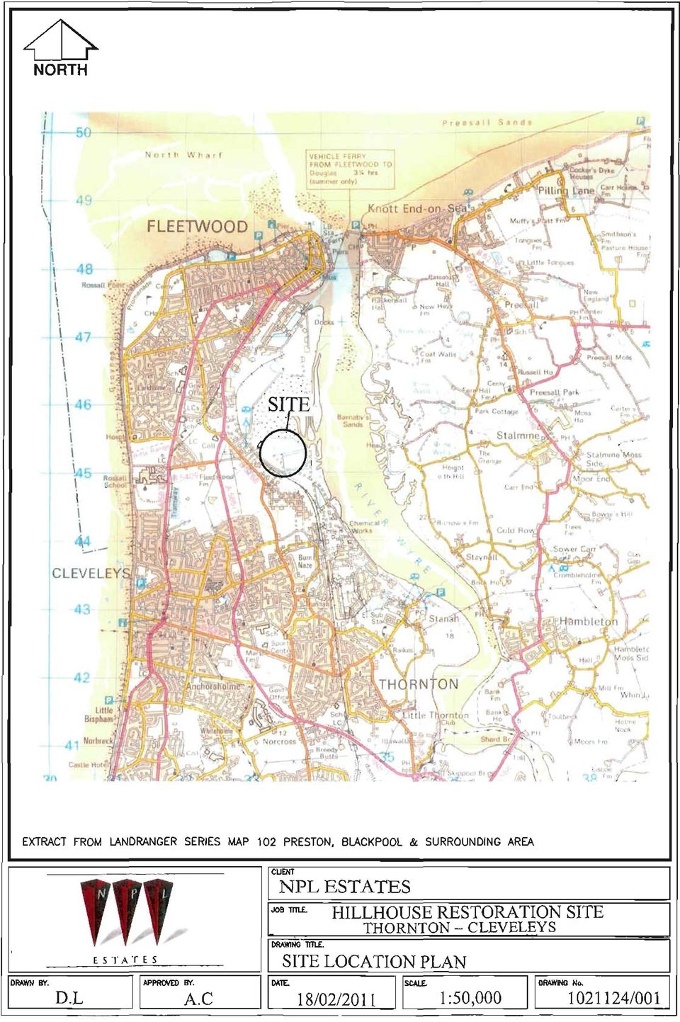
6 3. CURRENT SITUATION 3.1 Site Location and Description The site covers an area of approximately 4.3 hectares and is located to the north / north east of Fleetwood Road, Cala Gran Caravan Park and the former Fleetwood to Poulton le Fylde railway line and directly south of Jameson Road landfill site. Jameson Road lies to the north west of the application site with the Wyre Estuary to the east as shown on the site location plan in Appendix 1. The site has previously operated as a landfill and it is now proposed to undertake restoration works including remediation / reclamation of the existing site lagoons and the introduction a series of ditches within the site to provide and encourage ecological habitat. It is proposed to raise the current site levels significantly through the formation of a series of earth mounds in order to create a new soft landscaped topography. Following liaison with the EA, it is confirmed that the site lies in Flood Zone 1 but, on the basis that the site is over 1 hectare in area, it is necessary to provide a Flood Risk Assessment to accompany the detailed planning application for the proposed site restoration works. 3.2 Hydrology and Flooding Following liaison with the EA, it has been confirmed that the site lies in Flood Zone 1. On this basis, no detailed flood analysis is appropriate for the application site. It is noted that the application site is classified as more vulnerable in accordance with Table D2 in PPS25 on the basis of the previous site use as a landfill. 3.3 Probability of Flooding With reference to the relevant Environment Agency flood map, the site lies in Flood Zone 1 which comprises land assessed as having a less than 1 in 1000 annual probability of river or sea flooding in any year (<0.1%). From discussions with United Utilities and Wyre Borough Council, there are no historical records of flooding from sewers, highway drainage, overland flow or groundwater at the site. Following liaison with the EA, it has been confirmed that the site lies in Flood Zone 1 and no detailed flood analysis is therefore required for the application site. 6

7 3.4 Climate Change On the basis that the application site is to remain fully soft landscaped following restoration works, greenfield post development surface water discharge rates will apply and there is therefore no requirement for site attenuation of surface water in the post-restoration works situation. 3.5 Existing Site Surface Water Drainage The existing landfill site consists of Dry Tip Numbers 1 to 4 inclusive together with Lagoon Numbers 1 and 2. From a surface water drainage perspective, the two lagoons discharge surface runoff to the Wyre Estuary in the north eastern and south eastern corners of the site via a series of on site drainage ditches. Surface water from the four dry tips currently drains through infiltration. 7

8 4. PROPOSED DEVELOPMENT 4.1 Development Proposals The proposed application covers a detailed planning application for restoration of the former Hillhouse Landfill site. The application site is classified as more vulnerable in Table D2 of PPS25 due to its current landfill status. The proposed development is situated in Flood Zone 1 and there is therefore no requirement for any detailed flood analysis / modelling. 4.2 Surface Water Drainage Proposals The issue of surface water drainage to the post restoration site has been considered with reference to the hierarchy of surface water disposal as noted in the Building Regulations H3: i) Sustainable urban drainage systems (SUDS) ii) Discharge of surface water off site direct to watercourse iii) Discharge to adopted sewer Using the above hierarchy, the potential for using soakaways at the site was considered in relation to the nature of the existing soils. A study of the relevant BGS geological maps indicates that the site is underlain by landfill materials overlying relatively impermeable Tidal Flat clays and silts over mudstone bedrock. Furthermore, from a study of local BGS boreholes, a relatively high groundwater table is anticipated at the application site. SUDS are made up of one or more structures built to manage surface water runoff. They are used in conjunction with good management of the site to prevent flooding and pollution. There are four general methods of control: Filter strips and swales Filter drains and permeable surfaces Infiltration devices Basins and ponds 8

9 However, on the basis of the potential for soil contamination associated with the previous landfill site use, the use of post restoration surface water drainage soakaway systems is considered inappropriate. The Wyre Estuary is located at the north east corner of the application site. Discharge of surface water off the site into this watercourse is clearly feasible and will ensure that all surface water drainage will take place and is controlled within the site boundaries. Discharge of surface water from the post restoration re-modelled soft landscaped site surface will also act to ensure that there will be no off site flood flows during extreme weather conditions that may affect third party land ownerships. The re-modelling of the site topography will involve the formation of a series of raised soft landscaped mounds which typically fall at a gradient of circa 1 in 25 in order to encourage surface run off and prevent ground percolation. It is proposed that a series of land drains are constructed within the application site in order to collect surface run off from the re-modelled landscape which will discharge to the Wyre Estuary at the north eastern corner of the site. 4.3 Construction The final drainage system will be confirmed during the final drainage detailed design process. This system will be designed in order to prevent any existing surface water discharging from the site to the public sewers that service the area. 9

10 5. CONCLUSIONS 5.1 Flooding From discussions with United Utilities and Wyre Borough Council, there are no historical records of flooding from sewers, highway drainage, overland flow or groundwater at the site. Following liaison with the EA, it has been confirmed that the site lies in Flood Zone 1 and no detailed flood analysis is therefore required for the application site. The Environment Agency has stipulated that there are to be no off site surface water flood routes generated by the development during an enhanced 1 in 100 year storm. 5.2 Site Surface Water Drainage The issue of surface water drainage to the proposed development has been considered with reference to the hierarchy of surface water disposal as noted in the Building Regulations H3. SUDS infiltration systems are not considered likely to be appropriate for the development site, principally due to the potential presence of soil contamination associated with the previous landfill site use. The Wyre Estuary is located at the north eastern corner of the application site. Discharge of surface water off the site into this watercourse is clearly feasible and will ensure that all surface water drainage will take place and is controlled within the site boundaries. Discharge of site surface water from the re-modelled soft landscaped surface will also act to ensure that there will be no off site flood flows during extreme weather conditions that may affect third party land ownerships. It is proposed that a series of land drains are constructed within the application site at the base of the earth mounds in order to collect surface run off from the re-modelled site the land drains will then be connected to a collector drain prior to discharging to the Wyre Estuary at the north eastern corner of the site. 10

11 5.3 Flood Risk Management Measures There will be a site management Health and Safety document prepared in respect of the site. 5.4 Residual Risk There will be no off site overland flood flows generated by the proposed development. The proposed site restoration works will provide a positive impact on local flora and fauna that depend on the local watercourses for their survival. 11

12 APPENDIX 12

13 APPENDIX 1 SITE LOCATION PLAN 13

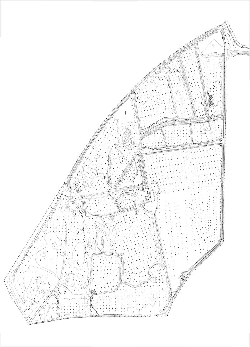
14 APPENDIX 2 EXISTING TOPOGRAPHICAL SURVEY 14

15 APPENDIX 3 PROPOSED SITE DEVELOPMENT PLAN 15

16
17

18
19

Littleport Co-located Schools
 Littleport Co-located Schools February 2015 Morgan Sindall Littleport Co-located Schools 330763 BNI BSE 003 C P:\Cambridge\Murdoch\EST\PROJECTS\330763 Littleport Co-located Schools\12.0 Documents\12.2
WEST LONDON PIPELINE AND STORAGE LIMITED AND UNITED KINGDOM OIL PIPELINES LIMITED
 WEST LONDON PIPELINE AND STORAGE LIMITED AND UNITED KINGDOM OIL PIPELINES LIMITED WLPS BUNCEFIELD REBUILD Flood Risk Assessment Green Lane Hemel Hempstead Hertfordshire HP2 7HZ September 2009 Prepared
Flood Risk Assessment and Drainage Statement
 Trinity College, Cambridge Proposed Relocation of Felixstowe Rifle Range, Land north of Nicholas Road, Trimley St Mary, Felixstowe Quality Assurance Site name: Client name: Proposed Relocation of Felixstowe
Planning, Health and Environment Division
 18 Planning, Health and Environment Division A Planning Guide to Sustainable Drainage Systems Introduction Working in co-operation with the Environment Agency, Severn Trent Water Ltd., the Highway Authority
11.2 The proposals to deal with the leachate within the closed Lodmoor North Landfill site are assessed in Chapter 10 Geology and Soils.
 Chapter Eleven Water Quality, Drainage and Hydrogeology Introduction 11.1 This Chapter considers the impact of the Relief Road on the hydrology of the area and considers both surface and groundwater. Runoff
Chapter 9: Water, Hydrology and Drainage Land West of Uttoxeter
 Chapter 9: Water, Hydrology and Drainage Land West of Uttoxeter ENVIRONMENTAL STATEMENT: VOLUME 1 9.1 INTRODUCTION 9.1.1 This Chapter considers the effects of the Project on surface water and groundwater
Recommendations for future developments
 C Recommendations for future developments C.1 Reducing flood risk through site layout and design C.1.1 C.1.2 Flood risk should be considered at an early stage in deciding the layout and design of a site
DRAINAGE MANAGEMENT PLAN. HERTFORDSHIRE RESIDUAL WASTE TREATMENT PLANT Hertfordshire County Council
 DRAINAGE MANAGEMENT PLAN HERTFORDSHIRE RESIDUAL WASTE TREATMENT PLANT Hertfordshire County Council EMPLOYER: Veolia Environmental Services (UK) Plc Veolia House 154A Pentonville Road London N1 9PE Copy
1.2 This technical note provides a preliminary investigation into the Flood Risk and provides outline drainage strategies.
 ODYSSEY MARKIDES TECHNICAL NOTE PROJECT : CHAILEY HOUSE, BLEWBURY JOB NO. : 14-216 NOTE TITLE : PRELIMINARY FLOODING AND DRAIANGE AUTHOR : STEVEN ROOTH APPROVED : ANDREAS MARKIDES DATE : 02/09/2014 1.0
Introduction. The vision of the West Yorkshire Combined Authority (WYCA) Flood Risk Partnership
 Flood Risk Partnership") WYCA SuDS Guidance Introduction As part of the government s continuing commitment to protect people and property from flood risk, the Department for Communities and Local Government and the Department
WYCA SuDS Guidance Introduction As part of the government s continuing commitment to protect people and property from flood risk, the Department for Communities and Local Government and the Department
London Road, Rayleigh Essex Flood Risk Assessment Addendum
 FINAL Countryside Properties (UK) Limited Submitted by AECOM 6-8 Greencoat Place London SW1P 1PL London Road, Rayleigh Essex Flood Risk Assessment May 2015 i Limitations AECOM Infrastructure & Environment
Vital Earth Composting Facility Flood Risk and Drainage Statement
 Vital Earth Flood Risk and Drainage Statement Final December 2011 Prepared for Vital Earth Ltd Revision Schedule Flood Risk and Drainage Statement December 2011 Rev Date Details Prepared by Reviewed by
FLOOD RISK ASSESSMENT AND DRAINAGE STRATEGY
 FLOOD RISK ASSESSMENT AND DRAINAGE STRATEGY London Rd. WATERLOOVILE FOR McCarthy & Stone Ltd. July 2010 Such Salinger Peters Ltd 30558-1- Flood Risk Assessment & Drainage Strategy Contents Paragraph Page
Taylor Wimpey UK Ltd. December 2007
 Taylor Wimpey UK Ltd December 2007 QM Issue/revision Issue 1 Revision 1 Revision 2 Revision 3 Remarks Draft For Planning Date 3 August 2007 20 December 2007 Prepared by D Gooding P Barton Signature Checked
Proposed Residential Development Land off Cody Road Waterbeach Cambridgeshire. Flood Risk Assessment
 Land off Cody Road Waterbeach Cambridgeshire Cedar Barn, White Lodge, Walgrave, Northampton, NN6 9PY T: F: E: W: 01604 781811 01604 781999 mail@jppuk.net jppuk.net Proposed Residential Development Land
Development at 2 St Albans Road, Kingston, London, KT25HQ
 Development at SuDS Report. Prepared for: Report prepared by: Dave Alonso Divine Ideas (UK) ltd Date: August 2015 Project/Issue number: Appendices Attached: 1510/01/SuDS A, B & C Divine Ideas (UK) Ltd
Guidance on the use of sustainable drainage systems (SUDS) and an overview of the adoption policy introduced by
 and an overview of the adoption policy introduced by") Guidance on the use of sustainable drainage systems (SUDS) and an overview of the adoption policy introduced by Easy guide to Sustainable drainage systems 02 Contents Page Introduction 05 Purpose of this
Guidance on the use of sustainable drainage systems (SUDS) and an overview of the adoption policy introduced by Easy guide to Sustainable drainage systems 02 Contents Page Introduction 05 Purpose of this
Issue: 2 Adopted by Council: 20/02/07. Directorate of Environment and Regeneration Planning Services
 Issue: 2 Adopted by Council: 20/02/07 Directorate of Environment and Regeneration Planning Services LOCAL PLANNIING GUIIDANCE NOTE NO..19:: SUSTAIINABLE DRAIINAGE SYSTEMS Background The provision of adequate
Flood Risk Assessment and Drainage Impact Assessment: Planning Guidance for Developers
 Flood Risk Assessment and Drainage Impact Assessment: Planning Guidance for Developers Development and Regeneration Services Glasgow City Council 229 George Street Glasgow G1 1QU May 2011 1. Introduction...-
SUSTAINABLE URBAN DRAINAGE SYSTEMS
 overflow can lead into a permeable conveyance system to increase further the benefit and reduce the need for pipe systems. Pollutant removal rates have been shown to be high, with some pollutants being
Bolton s Flood Risk Management Strategy
 Bolton s Flood Risk Management Strategy www.bolton.gov.uk Public Summary Bolton s Flood Risk Management Strategy Public Summary Introduction Over 5.5 million properties in England and Wales are at risk
London Borough of Merton Local Flood Risk Management Strategy
 Local Flood Risk Management Strategy Summary 2014-2020 Introduction In response to the severe flooding across large parts of England and Wales in summer 2007, the Government has recently enacted the Flood
London Borough of Waltham Forest LOCAL FLOOD RISK MANAGEMENT STRATEGY. Summary Document
 LOCAL FLOOD RISK MANAGEMENT STRATEGY Summary Document October 2013 Local Flood Risk Management Strategy Summary 1 Introduction 2 Partner responsibilities 3 What do we know about flooding in the borough?
Granville Road Estate, London Borough of Barnet. Flood Risk Assessment and Drainage Strategy August 2014. New Granville LLP
 Granville Road Estate, London Borough of Barnet Flood Risk Assessment and Drainage Strategy August 2014 New Granville LLP Document History JOB NUMBER: 237 DOCUMENT REF: Granville Road FRA REVISIONS: Final
Designed and produced by geo-graphicsdesign.com DP 300 3/02
 Designed and produced by geo-graphicsdesign.com DP 300 3/02 Guidance for Developers and Regulators Purpose This booklet is produced on behalf of the North East Scotland Flooding Advisory Group and is intended
London Borough of Croydon Local Flood Risk Management Strategy
 London Borough of Croydon Local Flood Risk Management Strategy Summary 2014-2020 Introduction In response to the severe flooding across large parts of England and Wales in summer 2007, the Government has
ENVIRONMENTAL STATEMENT: VOLUME 2 APPENDICES 11.1 TO 11.3
 NORTH LONDON WASTE AUTHORITY NORTH LONDON HEAT AND POWER PROJECT ENVIRONMENTAL STATEMENT: VOLUME 2 APPENDICES 11.1 TO 11.3 AD06.02 NORTH LONDON WASTE AUTHORITY NORTH LONDON HEAT AND POWER PROJECT ENVIRONMENTAL
The application site is on the edge of flood zones 1 and 2 with flood zone boundary cutting across part of the southern boundary of the site.
 Flood Risk Assessment Erection of Masjid/ Place of Worship, extended car parking following demolition of 11a Grafton Street & boundary treatment Land adjacent 11/ 11a Grafton Street, Preston, PR1 8JB 0723/
Flood Risk Assessment Breakspear House, Hemel Hempstead. Kier Property. October 08
 Flood Risk Assessment Breakspear House, Hemel Hempstead. Kier Property October 08 Prepared by:... Approved by:... Simon Marcos Keith Searle Principal Engineer Associate Director Flood Risk Assessment Rev
Sustainable Drainage Systems (SUDS) A guide for developers
 A guide for developers") Sustainable Drainage Systems (SUDS) A guide for developers We are the Environment Agency. It s our job to look after your environment and make it a better place for you, and for future generations. Your
Sustainable Drainage Systems (SUDS) A guide for developers We are the Environment Agency. It s our job to look after your environment and make it a better place for you, and for future generations. Your
SUSTAINABLE DRAINAGE IN LEEDS Supplementary Guidance No. 22 JULY 2004
 SUSTAINABLE DRAINAGE IN LEEDS Supplementary Guidance No. 22 JULY 2004 BACKGROUND This guidance provides information for developers on the use of sustainable drainage techniques in new developments. It
Anglian Water Services Limited. Sustainable drainage systems (SUDS) adoption manual
 adoption manual") Anglian Water Services Limited i towards sustainable water stewardship Sustainable drainage systems (SUDS) adoption manual Anglian Water Services Limited 1 Tomorrow s forecast is more frequent, more violent
Anglian Water Services Limited i towards sustainable water stewardship Sustainable drainage systems (SUDS) adoption manual Anglian Water Services Limited 1 Tomorrow s forecast is more frequent, more violent
Chapter 2 Spatial Portrait
 15 November 2013 Dear Julie Fylde Local Plan to 2030 Part 1 Preferred Options Thank you for the opportunity to meet with you on 9 October in respect of the above mentioned document. As discussed at the
Water and Flooding Position Statement
 Derby City Local Plan, Part 1: Core Strategy Water and Flooding Position Statement August 2015 1. Introduction 1.1 This position statement provides an update to the Derby HMA Joint Water Issues Paper which
Flood Risk Assessment
 Flood Risk Assessment Suffolk Agricultural Association Trinity Park, Ipswich July 212 Suffolk Agricultural Association Trinity Park, Ipswich July 212 Quality Assurance Site name: Client name: Trinity Park,
Newbiggin House Farm,
 Newbiggin House Farm, Near Waberthwaite Flood Investigation Report 32 Flood Event 30/8/2012 Cumbria County Council Version Undertaken by Reviewed by Approved by Date Preliminary Colin Parkes Anthony Lane
BUILDING SURVEYING 313021
 BUILDING SURVEYING 313021 Session topic SUDS - Sustainable Urban Drainage Systems Session objectives To examine various Sustainable Urban Drainage Systems (SUDS) for managing rainwater run-off and discuss
INFRASTRUCTURE, FLOOD PROTECTION AND REMEDIATION. Infrastructure Flood Protection Remediation Policies
 INFRASTRUCTURE, FLOOD PROTECTION AND REMEDIATION Infrastructure Flood Protection Remediation Policies DRAFT POOLBEG PLANNING SCHEME 196 FIGURE 9.1: UTILITIES WAYLEAVES Electricity Cables 8m Wayleave for
Flood Risk & Surface Water Management. Page 1 of 20
 Page 1 of 20 Flood Risk & Surface Water Management Flood Risk & Surface Water Management and the Planning Process Introduction The purpose of this document is to increase awareness of the potential of
Introduction to sustainable drainage. www.ciria.org/suds
 Introduction to sustainable drainage Outline of presentation Challenges of existing drainage Drivers for SuDS SuDS philosophy and principles Benefits of SuDS Examples of SuDS Challenges of SuDS Summary
PE21 7JE LEVEL 2 FLOOD RISK ASSESSMENT
 IE14/014/ymc Proposed Marstons Public House Swineshead Road Wyberton Fen Boston Lincolnshire PE21 7JE LEVEL 2 FLOOD RISK ASSESSMENT SUFFOLK: Registered Office: 7 Museum Street Ipswich Suffolk IP1 1HQ T
East Riding of Yorkshire Council
 East Riding of Yorkshire Council Lead Local Flood Authority Interim Standing Advice Revision A - April 2015 1. Introduction From April 2015 the Lead Local Flood Authority (LLFA) became a statutory consultee
FLOOD RISK ASSESSMENT
 SEVERN ROAD RESOURCE RECOVERY CENTRE FLOOD RISK ASSESSMENT REF 402.0036.00374 September 2009 Severn Road Resource Recovery Centre Ref: 402-0036-00374 Viridor Waste Management i PPS25 Flood Risk Assessment
2 ND SEPTEMBER 2014. Report of the Bi-Borough Executive Director for Transport and Technical Services
 London Borough of Hammersmith & Fulham COMMUNITY SAFETY, ENVIRONMENT & RESIDENTS SERVICES POLICY & ACCOUNTABILITY COMMITTEE 2 ND SEPTEMBER 2014 SURFACE WATER MANAGEMENT PLAN (SWMP) Report of the Bi-Borough
Proposed Construction of Basement Flood Risk Assessment. 35 Edwardes Square London W8 6HH
 Proposed Construction of Basement Flood Risk Assessment 35 Edwardes Square London W8 6HH 1 Introduction This FRA has been carried out in accordance with the National Planning Policy Statement (NPPF), the
Flood Risk Management in Southwark
 Flood Risk Management in Southwark 1 Presented to Borough & Bankside Community Council 25 th April 2012 By Flood and Drainage Team Agenda Item 11 IN BRIEF Background Legislation What have we done? What
Council, Municipal Building, Kingsway, Widnes, Cheshire, WA8 7QF. Greenspace. DEVELOPMENT PLAN ALLOCATION:
 APPLICATION NO: LOCATION: PROPOSAL: WARD: PARISH: CASE OFFICER: AGENT(S) / APPLICANT(S): DEVELOPMENT PLAN ALLOCATION: 13/00397/HBCOUT Land at Widnes Recreation Ground, Liverpool Road, Widnes, Cheshire.
LONDON INFRASTRUCTURE PLAN 2050 BUILDING A BIGGER AND BETTER LONDON
 LONDON INFRASTRUCTURE PLAN 2050 BUILDING A BIGGER AND BETTER LONDON GROWTH We estimate that London s population became bigger than ever in February 2015. We reached a population of 8.6 million people,
A DESIGN AND ADOPTION GUIDE
 SUSTAINABLE DRAINAGE A DESIGN AND ADOPTION GUIDE Issue 2 July 2013 Issue History Issue Change Release Date 1 Document release 2 Planning Policy Sub February 2013 July 2013 2 PREFACE Sustainable Drainage
Low Impact Development Checklist
 New Jersey Stormwater Best Management Practices Manual February 2004 A P P E N D I X A Low Impact Development Checklist A checklist for identifying nonstructural stormwater management strategies incorporated
Land to the rear of the Black Bull Public House Flood Risk Assessment March 10, 2014 Version 1.0 Ref: RAB 148
 Land to the rear of the Black Bull Public House Flood Risk Assessment March 10, 2014 Ref: RAB 148 Lindsey Phillips Turnbull Tweedale Ltd 61 Oaken Lanes Codsall South Staffordshire WV8 2AW R A B C O N S
Sutton Harbour Holdings PLC. March 2007
 Sutton Harbour Holdings PLC March 2007 Contents!! " # # $ % % &'(&'' ) ) ( * + ', *!$ -,!'! #. / $$ #% 00& ' 00&1 $ Executive Summary!! " WSP Development and Transportation has been engaged by Sutton
approval of matters specified in conditions; and The Town and Country Planning (Development Management Procedure) (Scotland) Regulations 2013
 (Scotland) Regulations 2013") Application for: planning permission; planning permission in principle; further applications; approval of matters specified in conditions; and mineral workings (if the planning authority do not have a
Application for: planning permission; planning permission in principle; further applications; approval of matters specified in conditions; and mineral workings (if the planning authority do not have a
Carterton Drainage Strategy. Stage 1 - Initialise/Prepare
 Carterton Drainage Strategy Stage 1 - Initialise/Prepare Introduction Why sewer flooding Britain s first sewerage systems were constructed 150 years ago in the Victorian era, and have served us well for
R enfrewshire Local Plan. Safe Environment. Page. Flooding & Sustainable Urban Drainage 163 Contaminated Land 175 Noise 177 Major-Accident Hazards 179
 R enfrewshire Local Plan Safe Environment Page Flooding & Sustainable Urban Drainage 163 Contaminated Land 175 Noise 177 Major-Accident Hazards 179 16 Flooding and Sustainable Urban Drainage OVERVIEW Flooding
CHAPTER 372-68 WAC WATER POLLUTION CONTROL AND ABATEMENT PLANS FOR SEWAGE DRAINAGE BASINS
 CHAPTER 372-68 WAC WATER POLLUTION CONTROL AND ABATEMENT PLANS FOR SEWAGE DRAINAGE BASINS Last Update: 6/8/88 WAC 372-68-010 Authority. 372-68-020 Purpose. 372-68-030 Definitions. 372-68-040 Planning guide.
Flash Flood Science. Chapter 2. What Is in This Chapter? Flash Flood Processes
 Chapter 2 Flash Flood Science A flash flood is generally defined as a rapid onset flood of short duration with a relatively high peak discharge (World Meteorological Organization). The American Meteorological
Chippenham Surface Water Management Plan Intermediate Assessment of Groundwater Flooding Susceptibility
 Chippenham Surface Water Management Plan Intermediate Assessment of Groundwater Flooding Susceptibility Phase 1 & 2 November 2011 Prepared for Revision Schedule Surface Water Management Plan Intermediate
Strategic Flood Risk Assessment Update 2015
 Strategic Flood Risk Assessment Update 2015 On behalf of Contents Glossary... iv Executive Summary... 1 1 Introduction... 4 1.1 Overview... 4 1.2 Future Development in Lewisham Borough... 5 2 SFRA Approach...
APPENDIX 9 INFRASTRUCTURE SERVICING REPORT
 APPENDIX 9 INFRASTRUCTURE SERVICING REPORT Lot 50 Cockram Street, Mundijong Infrastructure Servicing Report Peet Ltd August 2012 LOT 50 COCKRAM STREET, MUNDIJONG-INFRASTRUCTURE SERVICING REPORT Project
Guidance Notes: GARDEN FLOODING
 Page 1 of 7 Guidance Notes: GARDEN FLOODING If you are unsure about anything within these notes then please contact the Flood Risk Management (FRM) team using the details at the end of this document. Water
STAFF REPORT TO COMMITTEE OF THE WHOLE
 STAFF REPORT TO COMMITTEE OF THE WHOLE DATE: November 7 2012 TO: FROM: SUBJECT: ATTACHMENT(S): COMMITTEE OF THE WHOLE GINA LAYTE-LISTON, SUPERVISOR, WASTEWATER Stormwater Management Funding Strategy None
Creating the environment for business
 1. Introduction 1.1 Introduction to Water Cycle Strategies (WCS) 1.1.1 Background The water cycle describes the pathways and processes through which water moves through the natural and built environment,
DOÑA ANA COUNTY DESIGN STORM CRITERIA GUIDELINES FOR COMMERCIAL AND RESIDENTIAL SITES. Run-off Analysis Methods
 DOÑA ANA COUNTY DESIGN STORM CRITERIA GUIDELINES FOR COMMERCIAL AND RESIDENTIAL SITES Run-off Analysis Methods This document sets forth the minimum design, technical criteria and specifications for the
NOVEMBER 2009 [ISSUE 5]
![NOVEMBER 2009 [ISSUE 5]](/thumbs/28/12834647.jpg "NOVEMBER 2009 [ISSUE 5]") 375 401 BRIGHTON ROAD CROYDON FLOOD RISK ASSESSMENT CLIENT: TRITHING LTD [ISSUE 5] Head Office: Unit 2 York House Edison Park Dorcan Way Swindon Wiltshire SN3 3RB Tel. 01793 619965 Fax. 01793 619967 Email:
375 401 BRIGHTON ROAD CROYDON FLOOD RISK ASSESSMENT CLIENT: TRITHING LTD [ISSUE 5] Head Office: Unit 2 York House Edison Park Dorcan Way Swindon Wiltshire SN3 3RB Tel. 01793 619965 Fax. 01793 619967 Email:
CLACKAMAS COUNTY ZONING AND DEVELOPMENT ORDINANCE
 1008 STORM DRAINAGE (3/24/05) 1008.01 PURPOSE To minimize the amount of stormwater runoff resulting from development utilizing nonstructural controls where possible, maintain and improve water quality,
Stormwater management around the world Lessons from Novatech 2010 Dennis Corbett and Marion Urrutiaguer
 Stormwater management around the world Lessons from Novatech 2010 Dennis Corbett and Marion Urrutiaguer Novatech 2010, the 7th international conference on sustainable techniques and strategies in urban
Wiltshire SWMP Project Governance Framework
 Wiltshire SWMP Project Governance Framework Final Framework Prepared on behalf of This document has been prepared in accordance with the scope of Scott Wilson's appointment with its client and is subject
rescue and relief efforts in the aftermath of flooding, (iii) repair of flood damaged public facilities and utilities, and
 repair of flood damaged public facilities and utilities, and") 1. Purpose (1) It is the purpose of this Ordinance to protect human life, health, and property from flood conditions, to preserve the ability of floodplains to carry and discharge a base flood, and to
1. Purpose (1) It is the purpose of this Ordinance to protect human life, health, and property from flood conditions, to preserve the ability of floodplains to carry and discharge a base flood, and to
PINKHAM WAY ISSUE 01 STRATEGIC RISK ASSESSMENT 27th March 2015
 PINKHAM WAY ISSUE 01 STRATEGIC RISK ASSESSMENT 27th March 2015 Objective: Context / Basis of Reference: To identify the probable, relative, high-level Planning Risks, Physical Risks and Cost Risks attached
A Developer s Guide: Watershed-Wise Development
 A Developer s Guide: Watershed-Wise Development Environmental Protection What is a watershed? It does not matter how far away you build from a creek, lake, or the ocean, you are in a watershed. Another
ENVIRONMENT ACT PROPOSED TERMS OF REFERENCE FOR PUBLIC REVIEW AND COMMENT NOVA SCOTIA DEPARTMENT OF TRANSPORTATION AND PUBLIC WORKS
 ENVIRONMENT ACT PROPOSED TERMS OF REFERENCE FOR PUBLIC REVIEW AND COMMENT NOVA SCOTIA DEPARTMENT OF TRANSPORTATION AND PUBLIC WORKS Beaver Bank Bypass Highway 101 to the Beaver Bank Road Halifax County,
Welcome Welcome to the public exhibition for development at Bowman Field. This exhibition provides an overview of the proposals for the site.
 Welcome Welcome to the public exhibition for development at Bowman Field. This exhibition provides an overview of the proposals for the site. Background & Planning Context The Site The site is an area
Development Brief for the Gedling Colliery and Chase Farm site
 Development Brief for the Gedling Colliery and Chase Farm site Contents 1. Introduction 2. The Site 3. Planning Policy Context 4. Development Requirements Figures 1. Site Location 2. Gedling Access Road
URBAN DRAINAGE CRITERIA
 URBAN DRAINAGE CRITERIA I. Introduction This division contains guidelines for drainage system design and establishes a policy for recognized and established engineering design of storm drain facilities
Essex County Council Flood Investigation Report
 Essex County Council Stock City of Chelmsford Rev Date Details Author Checked and Approved By 01 February 2015 Draft report for stakeholder consultation Ed Clarke Flood Investigation Engineer Lucy Shepherd
Costs and Benefits of Sustainable Drainage Systems
 Costs and Benefits of Sustainable Drainage Systems Committee on Climate Change July 2012 Final Report 9X1055 CONTENTS Page 1 INTRODUCTION 1 1.1 Background 1 1.2 Report Structure 1 2 LITERATURE REVIEW
Carmarthenshire LDP Site Assessment Proforma
 Carmarthenshire LDP Site Assessment Proforma 1. Site Details Ref: SC1/h1 Site Ref (where applicable): Location: Parc Puw, Drefach Felindre Site Area (Ha): Eisting Use* *if candidate site as proposed by
The Planning System and Flood Risk Management
 20 The Planning System and Flood Risk Management Guidelines for Planning Authorities November 2009 The Planning System and Flood Risk Management Guidelines for Planning Authorities Contents PAGE Ministers
MINERALS AND ASSOCIATED WASTE APPLICATIONS APPLICATION FORM
 MINERALS AND ASSOCIATED WASTE APPLICATIONS APPLICATION FORM 1. Applicant Details (See guidance note 1) 2. Agent Details Please complete if the applicant has an agent (See guidance note 2) * Title: * Forename:
WETLAND RESTORATION PROGRAM WATER ACT APPROVAL ADMINISTRATIVE GUIDE
 WETLAND RESTORATION PROGRAM WATER ACT APPROVAL ADMINISTRATIVE GUIDE May 24, 2005 Table of Contents Introduction...3 Definitions...3 Types of Wetland Restorations...4 Re-Contouring...4 Engineered...4 Water
NAPA COUNTY WATERSHED SYMPOSIUM
 Planning, Building, and Environmental Services NAPA VALLEY GROWTH NAPA COUNTY WATERSHED SYMPOSIUM Plunging Forward May 15, 2015 1 YOU CAN T CROSS THE SEA MERELY BY STANDING AND STARING AT THE WATER. Rabindranath
Storm water strategy of Turku City Citywater Storm water expert meeting 11.12.2014 Turku
 Storm water strategy of Turku City Citywater Storm water expert meeting 11.12.2014 Turku 17.12.2014 Olli-Pekka Mäki 1 Background of storm water strategy Strategy is based on Baltic Sea Challenge Action
Drainage Analysis for the McKownville Area
 Drainage Analysis for the McKownville Area Town of Guilderland Albany County, New York Prepared by: DELAWARE ENGINEERING, P.C. 28 Madison Avenue Extension Albany, New York 12203 June 2010 Town of Guilderland
City of Atlanta. Department of Watershed Management. Post-Development Stormwater Management Ordinance Summary of Revisions
 City of Atlanta Department of Watershed Management Post-Development Stormwater Management Ordinance Summary of Revisions Cory Rayburn, CPESC Environmental Program Manager crayburn@atlantaga.gov Stormwater
SUFFOLK COASTAL DISTRICT COUNCIL DOMESTIC FLOOD PROTECTION POLICY
 SUFFOLK COASTAL DISTRICT COUNCIL DOMESTIC FLOOD PROTECTION POLICY 1. Introduction 1.1 The Council recognises the threat to local communities from flooding following severe weather events and as a result
London Borough of Newham. Local Flood Risk Management Strategy
 London Borough of Newham Local Flood Risk Management Strategy Version 5, September 2015 Local Flood Risk Management Strategy for the London Borough of Newham Document Management: Version Control Title:
London Borough of Bexley. Bexley Strategic Flood Risk Assessment Level-1. Bexley SFRA Level-1 Report. August 2010
 London Borough of Bexley Bexley Strategic Flood Risk Assessment Level-1 Bexley SFRA Level-1 Report Copyright and Non-Disclosure Notice The contents and layout of this report are subject to copyright owned
Surface Water Management: Interim Guidance for Developers
 Surface Water Management: Interim Guidance for Developers www.shropshire.gov.uk Contents Executive Summary 1. Introduction...1 2. National Policy Context...2 Making Space for Water...2 Future Water...2
DESCRIPTION OF STORMWATER STRUCTURAL CONTROLS IN MS4 PERMITS
 DESCRIPTION OF STORMWATER STRUCTURAL CONTROLS IN MS4 PERMITS Phase I MS4 permits require continuous updating of the stormwater system inventory owned and operated by the MS4. They also include inspection
Mechanical Biological Treatment Facility
 Mechanical Biological Treatment Facility Former Britannia Zinc Site, Avonmouth Environmental Statement Non Technical Summary Non Technical Summary July 09 New Earth Solutions Group Ltd Mechanical Biological
Applying MIKE SHE to define the influence of rewetting on floods in Flanders
 Applying MIKE SHE to define the influence of rewetting on floods in Flanders MARK HENRY RUBARENZYA 1, PATRICK WILLEMS 2, JEAN BERLAMONT 3, & JAN FEYEN 4 1,2,3 Hydraulics Laboratory, Department of Civil
Strategic Flood Risk Assessment
 local development framework Strategic Flood Risk Assessment LOCAL DEVELOPMENT FRAMEWORK ROYAL BOROUGH OF KINGSTON UPON THAMES Level 1 and 2 April 2011 Contents Executive Summary 5 Part 1 - Aiding Planning
Stormwater Management Functional Servicing Report
 Stormwater Management Functional Servicing Report Part of Lot 12, Concession 10 Township of Cavan Monaghan Ian Cameron Rural Subdivision Engage Project No. 14016 Engage Engineering Ltd. January 7, 2015
Action plans for hotspot locations - Ash Study
 Appendix 9 Action plans for hotspot locations - Ash Study Ash Vale North 1. Local evidence indicates the culvert could not discharge during December 2013 because the outlet was blocked on the western side
Land Disturbance, Erosion Control and Stormwater Management Checklist. Walworth County Land Conservation Department
 Land Disturbance, Erosion Control and Stormwater Management Checklist Walworth County Land Conservation Department The following checklist is designed to assist the applicant in complying with the Walworth
Development proposals will require to demonstrate, according to scale, type and location, that they:-
 Appendix 2 : Relevant Development Plan Policies Angus Local Plan Review 2009 Policy S1 : Development Boundaries (a) Within development boundaries proposals for new development on sites not allocated on
1. Purpose and scope. 2. SEPA's role in hydropower and planning
 Page no: 1 of 10 1. Purpose and scope 1.1 The purpose of this note is to provide guidance on the approach that we will take when dealing with hydropower development management consultations. We welcome
(http://www.molevalley.gov.uk/media/pdf/c/r/srfa_-_updated_jnauary_2012.pdf
 Possible Submission about Water and Flooding (See maps 3a and 3b) From Mole Valley Local Development Framework: Strategic Flood Risk Assessment Update 2012 (http://www.molevalley.gov.uk/media/pdf/c/r/srfa_-_updated_jnauary_2012.pdf
London Borough of Bromley LEAD LOCAL FLOOD AUTHORITY UPDATE AND GRANT DRAW-DOWN
 Report No. ES15041 London Borough of Bromley PART ONE - PUBLIC Decision Maker: Executive Date: 9 th September 2015 Decision Type: Non-Urgent Executive Non-Key Title: Contact Officer: Chief Officer: Ward: