Capitalizing on Flooding as Passive. Hearts and Minds of the Musselshell
|
|
|
- Leon Austin O’Connor’
- 10 years ago
- Views:
Transcription
1 Capitalizing on Flooding as Passive Restoration: Hearts and Minds of the Musselshell Karin Boyd Applied Geomorphology, Inc. Chris Boyer, Kestrel Aerial Services, Inc.

2 Strategically t Adopting Flood Impacts as Passive Restoration Requires a good sell for the No Action alternative That opportunity is time-sensitive Culturally un-nerving Program flexibility helps

3 ~ sq mii

4 Historic Impacts: :The Milwaukee Road ( ) 19% Shortening over ~100 Miles Extensive Floodplain Isolation Chris Boyer, Kestrel Aerial Services, Inc.

5 Pre-Flood Incised Isolated Floodplain (Vertical and Lateral) Cleared Riparian Corridor Fish Passage Barriers

6 Spring 2011 Massive Snowpack, Late Melt, Heavy Rains

7 Spring 2011 Massive Snowpack, Late Melt, Heavy Rains Average Snowpack

8 Spring 2011 Massive Snowpack, Late Melt, Heavy Rains 2011 Snowpack

9 Spring 2011 Massive Snowpack, Late Melt, Heavy Rains 2011 RAIN

10 May-June, 2011 (Billings Gazette)
")
11 Peak Discharge of ~130 year event Chris Boyer, Kestrel Aerial Services, Inc.

12 Duration: Weeks of high flows Q10 Roundup = 4,850 cfs Q10 Mosby = 12,700 cfs

13 April 26, 2010
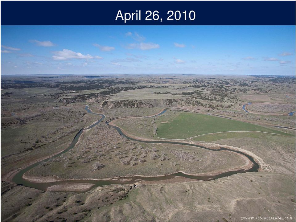
14 May 23, 2011 (Peak)

15 June 16, 2011 (Recession)

16 Chris Boyer, Kestrel Aerial Services, Inc

17
18 Musselshell Watershed Rehabilitation Project DNRC Proposal Submitted August 29, 2011 Lower Musselshell Conservation District Develop a multi-disciplined assessment team to work with impacted producers developing plans respectful to their needs and the river. RIVER ASSESSMENT TRIAGE TEAM (RATT)

19 The RATT Riparian Ecology Hydrology Agriculture Water Rights Fisheries Geomorphology

20 Fall Site Visits

21 1. Assess Impacts RATT Responsibilities 2. Develop Short-Term Strategies 3. Develop Long-Term Strategies 4. Identify Conservation Opportunities 5. Identify Resources 6. Develop Monitoring Strategies 7. Provide Each Landowner With a Site Report
22
23 Types of Damage Avulsions Breached Railroad Berms Floodplain Deposition Siphon Damage Floodplain Scour Pump Site Damage Lost Access Diversion Structure Breaches
24 Conservation Opportunities Inset Floodplain Development Floodplain Access Fish Passage Riparian i Recovery Habitat Rejuvenation Wetland Creation We should leverage this catastrophe for the public good.
25 Avulsions: 59 total ~37 Miles of Channel Abandoned
26 Abandon ned Channel Len ngth (ft) MusselshellRiver 2011 Abandoned Channel Length R1 R2 R3 R4 R5 R6 R7 R8 R9 R10 Cumulative Length River Mile ned (miles) Cumulative Length Abando ~37 Miles of 2009 Channel Abandoned
27 2009
28 2011
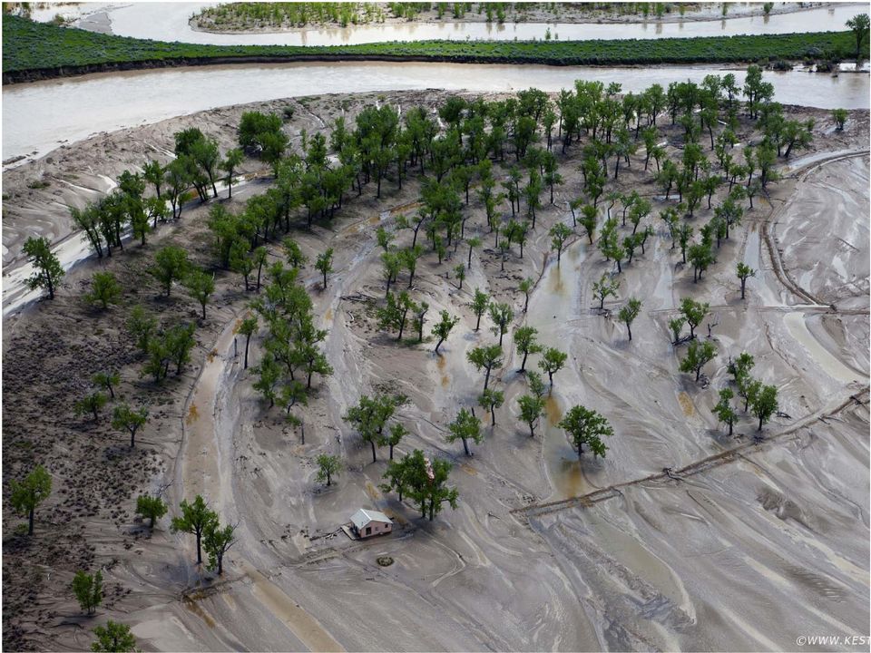
29 2009
30 2011
31 Avulsion Concerns Pump Sites Roads/Access Erosion
32 Avulsion Opportunities Targeted Recharge Wetland Function Riparian Protections
33 Governor approves abbreviated process for changes in point of diversion (POD) Pump Site Pump Site
34 Railroad Grade Breaches
35 Concerns: Flood Control A total of 31 Breaches Erosion Control Road Access
36 Opportunities: Overflow Return Points
37 Floodplain Deposition Chris Boyer, Kestrel Aerial Service
38 Concerns: Floodplain Deposition Crop Suitability Weeds
39 Opportunity: Riparian Recovery
40
41
42 NRCS Creates Cottonwood Easement Program Flood Damage Recovery Special Initiative
43 Fall 2012 Averages 129,000 Cottonwoods/acre 17,000 Willows/acre
44 350 Miles of Restoration in Three Weeks Passage Barrier Removal Riparian Colonization LWD Inset Floodplain
45 The RATT Approach Conveying a coordinated, d consistent t message towards an ecologically- supportive outcome. Get out there fast Listen to the story Go multidisciplinary Document the event Make a case for opportunity Monitor the results
46 Special thanks to: Chris Boyer (Kestrel Aviation) Bill Milt Bill Milton (Musselshell Watershed Coalition)
47 Musselshell RATT
48
49
50
51
52
53
Floodplain Connectivity in Restoration Design
 Floodplain Connectivity in Restoration Design 2015 Symposium on Restoration in a Contaminated Environment: Lessons Learned and Challenges in Moving Forward Part II April 2015 Karin Boyd Applied Geomorphology,
Rhode Island NRCS received approximately $2.4 million in ARRA funds to implement four floodplain easement projects.
 American Recovery and Reinvestment Act (ARRA) Emergency Watershed Protection Program Floodplain Easements Rhode Island Natural Resources Conservation Service Rhode Island NRCS received approximately $2.4
How To Manage Water Resources In The Yakima Basin
 Yakima Basin Integrated Water Resource Management Plan October 23, 2014 Presented by Derek Sandison, Director Office of Columbia River Photo Courtesy of Tom Ring Basin size: 6,155 sq. miles Population:
Post-Flood Assessment
 Page 1 of 7 Post-Flood Assessment CHAPTER 4 AGENCY COORDINATION Agency coordination is an essential element for the operation of the flood management systems in the Central Valley. Due to the nature of
Chehalis River Basin Flood Damage Reduction 2013-2015 Capital Budget Approved by Legislature in June 2013
 Chehalis River Basin Flood Damage Reduction 2013-2015 Capital Budget Approved by Legislature in June 2013 1. Design alternatives for large capital flood projects (basinlevel water retention and Interstate
Oregon. Climate Change Adaptation Framework
 Oregon Climate Change Adaptation Framework Oregon Environmental Quality Commission Climate Change Adaptation Framework Presentation at a glance: Purposes of the framework Participating agencies Climate
St. Vrain Watershed Master Plan Thursday, January 23 10:00 a.m. 12:15 p.m.
 St. Vrain Watershed Master Plan Thursday, January 23 10:00 a.m. 12:15 p.m. City Council Study Session Room City of Longmont Civic Center, 350 Kimbark Street, Longmont Minutes 1. Introductions a. Jeff Crane
ECONOMIC ANALYSIS FLOOD DAMAGE REDUCTION. Lower Carmel River Floodplain Restoration and Enhancement Project
 ECONOMIC ANALYSIS FLOOD DAMAGE REDUCTION Lower Carmel River Floodplain Restoration and Enhancement Project I. Description of the Project and its Relationship to Other Projects in the Proposal The Lower
Section 4 General Strategies and Tools
 Section 4 General Strategies and Tools Key planning issues for WRIA 35 have been identified in Sections 5 and 6 in the areas of water supply, instream flow, water quality, and aquatic habitat. General
Napa River Restoration Projects
 Napa River Restoration Projects Shaun Horne, Napa County, [email protected] Jeremy Sarrow, Napa County, [email protected] The Napa River flows though one of the most scenic landscapes
FLOOD PROTECTION BENEFITS
 IV. (340 points) Flood Protection Benefits A. Existing and potential urban development in the floodplain (50) 1. Describe the existing and potential urban development at the site and the nature of the
 Coldwater Heritage Partnership Implementation Grant Final Report Morrison Run Watershed Restoration Project Western Pennsylvania Conservancy Project Summary The goal of the Morrison Run Watershed Restoration
Interim Technical Guidelines for the Development of Environmental Management Plans for Underground Infrastructure Revised - July 2013.
 Interim Technical Guidelines for the Development of Environmental Management Plans for Underground Infrastructure Revised - July 2013 Rationale Underground infrastructure may be at risk from valley, streambank
Mission Creek Flood Control & Restoration Project. City of Fremont, Alameda County
 Mission Creek Flood Control & Restoration Project City of Fremont, Alameda County Agenda Background Why are proposed improvements necessary? Proposed project components Challenges Construction schedule/phasing
Available FSA and NRCS Disaster Assistance Programs Crop Insurance: Prevented Planting and Failed Acreage Considerations Click on title for video
 06.08.15 Webinar Video Available FSA and NRCS Disaster Assistance Programs Crop Insurance: Prevented Planting and Failed Acreage Considerations Click on title for video Hosted by University of Arkansas
General Permit for Activities Promoting Waterway - Floodplain Connectivity [working title]
![General Permit for Activities Promoting Waterway - Floodplain Connectivity [working title]](/thumbs/39/18645965.jpg "General Permit for Activities Promoting Waterway - Floodplain Connectivity [working title]") General Permit for Activities Promoting Waterway - Floodplain Connectivity [working title] Purpose These rules set forth the conditions under which a person may, without an individual removal-fill permit
General Permit for Activities Promoting Waterway - Floodplain Connectivity [working title] Purpose These rules set forth the conditions under which a person may, without an individual removal-fill permit
Miquon Creek STREAM RESTORATION PROJECT WHO WE ARE
 Miquon Creek STREAM RESTORATION PROJECT WHO WE ARE Introductions Brett Long, PE Project Permitting & Construction Oversight Chris Streb, PE Project Designer & Construction Oversight Assistance WHO WE ARE
The Basics of Chapter 105 Waterways and Wetlands Permitting in PA
 The Basics of Chapter 105 Waterways and Wetlands Permitting in PA April 17, 2013 Goal To develop a basic understanding of PA Department of Environmental Protection (DEP) and US Army Corps of Engineers
1800 Washington Boulevard, Baltimore, MD 21230-1718 www.mde.maryland.gov 410-537-3000 800-633-6101 TTY Users 800-735-2258 Larry Hogan, Governor Boyd
 ENVIRONMENTAL SITE DESIGN (ESD) REDEVELOPMENT EXAMPLES OCTOBER 2010 1800 Washington Boulevard, Baltimore, MD 21230-1718 www.mde.maryland.gov 410-537-3000 800-633-6101 TTY Users 800-735-2258 Larry Hogan,
Table 2: State Agency Recommendations Agency of Agriculture, Food and Markets
 SUPPORTING INFORMATION ASSOCIATED WITH THE ALLOCATION PRIORITIES FOR CLEAN WATER FUND BOARD Table 2: State Agency Recommendations Agency of Agriculture, Food and Markets 1 Agriculture AAFM On-Farm Implementation
3. The submittal shall include a proposed scope of work to confirm the provided project description;
 QIN Shoreline Master Program Project Summary The Shoreline Master Program (SMP) development process for the Quinault Indian Nation (QIN) includes the completion of inventory and analysis report with corresponding
Habitat rehabilitation for inland fisheries
 Habitat rehabilitation for inland fisheries FAO FISHERIES TECHNICAL PAPER 484 Global review of effectiveness and guidance for rehabilitation of freshwater ecosystems Cover photos : Left: excavation of
Prepared By: Tom Parker Geum Environmental Consulting, Inc.
 Prepared By: Tom Parker Geum Environmental Consulting, Inc. Topics covered: Definition of riparian and floodplain restoration Floodplain attributes as a basis for developing criteria for restoration designs
The Teton Creek Restoration Project Summary:
 The Teton Creek Restoration Project Summary: The Teton Creek Restoration Project area extends for approximately one mile upstream from the Cemetery Road Bridge and includes the Aspen Pointe, The Aspens
Water Quality Management
 Water Quality Management Sustainable agriculture practices detailed in other sections of this publication are important ways to maintain or improve water quality on the farm and downstream from the farm.
FLOOD PROTECTION AND ECOSYSTEM SERVICES IN THE CHEHALIS RIVER BASIN. May 2010. Prepared by. for the. 2010 by Earth Economics
 FLOOD PROTECTION AND ECOSYSTEM SERVICES IN THE CHEHALIS RIVER BASIN May 2010 Prepared by for the Execubve Summary The Chehalis Basin experienced catastrophic flooding in 2007 and 2009. In response, the
Appendix A. Lists of Accomplishments and Project Costs. UMRWD 10 Year Plan Update. Appendix A UPPER MINNESOTA RIVER WATERSHED DISTRICT
 UPPER MINNESOTA RIVER WATERSHED DISTRICT Lists of Accomplishments and Project Costs 10 Year Plan Update UMRWD 10 Year Plan Update Page A 1 UMRWD LIST OF ACCOMPLISHMENTS Since its inception in 1967, the
Prattsville Berm Removal Project. 1.0 Project Location
 Prattsville Berm Removal Project 1.0 Project Location The project site is located between the New York State Route 23 Bridge over the Schoharie Creek and the Schoharie Reservoir. The restoration plan encompassed
Public Law 84-99 and Non-Structural Alternatives to Levee Repairs
 Public Law 84-99 and Non-Structural Alternatives to Levee Repairs Presented by: Mr. Jerry A. Skalak, CFM U.S. Army Corps of Engineers Rock Island District and Mr. Tom Oswald Iowa Homeland Security and
JOB DESCRIPTION. GS-11 $46,006 - $59,801 Annual/Full Benefits GS-12 $55,138 - $71,679 Annual/Full Benefits
 OPEN: CLOSE: OR UNTIL FILLED EXEMPT NON-EXEMPT_X_ JOB DESCRIPTION POSITION: RESPONSIBLE TO: SALARY: FLUVIAL GEOMORPHOLOGIST Senior Aquatics Biologist GS-11 $46,006 - $59,801 Annual/Full Benefits GS-12
Flooding Fast Facts. flooding), seismic events (tsunami) or large landslides (sometime also called tsunami).
, seismic events (tsunami) or large landslides (sometime also called tsunami).") Flooding Fast Facts What is a flood? Flooding is the unusual presence of water on land to a depth which affects normal activities. Flooding can arise from: Overflowing rivers (river flooding), Heavy rainfall
Flooding Fast Facts What is a flood? Flooding is the unusual presence of water on land to a depth which affects normal activities. Flooding can arise from: Overflowing rivers (river flooding), Heavy rainfall
Lower Raritan Watershed Management Area Stormwater & Flooding Subcommittee Strategy Worksheet LRSW-S3C1
 Strategy Name: Reduce Existing Potential for Flood Damages LRSW-S3C1. Develop and implement a program to: Minimize flood damages through the use of structural measures. Minimize flood damages through the
Ouachita River Floodplain Restoration Upper Ouachita NWR, Louisiana
 Ouachita River Floodplain Restoration Upper Ouachita NWR, Louisiana Interior Hydrologic Restoration Plan Mollicy Farms Unit The Nature Conservancy Louisiana Field Office 2011 Cover: Sediment laden water
Resolving complex issues with large scale river restoration; a case study: the San Joaquin River in California
 IWA Publishing 2011 Water Practice & Technology Vol 6 No 4 doi:10.2166/wpt.2011.074 Resolving complex issues with large scale river restoration; a case study: the San Joaquin River in California William
Flood Risk Management
 Flood Risk Management Value of Flood Risk Management Every year floods sweep through communities across the United States taking lives, destroying property, shutting down businesses, harming the environment
Flood Risk Management
 Flood Risk Management Value of Flood Risk Management Value to Individuals and Communities Every year floods sweep through communities across the United States taking lives, destroying property, shutting
Final Report. Dixie Creek Restoration Project. Funded by Plumas Watershed Forum
 Final Report Dixie Creek Restoration Project Funded by Plumas Watershed Forum Plumas Corporation January 2009 1 Background FR-CRM staff presented this project to the Dixie Valley Landowners Association
COMPREHENSIVE PLAN SECTION B, ELEMENT 4 WATER RESOURCES. April 20, 2010 EXHIBIT 1
 COMPREHENSIVE PLAN SECTION B, ELEMENT 4 WATER RESOURCES April 20, 2010 EXHIBIT 1 ELEMENT 4 WATER RESOURCES TABLE OF CONTENTS 4.1 INTRODUCTION 4.2 GOALS AND POLICIES 4.2.A General Goals and Policies 1 4.2.B
GLOSSARY OF TERMS CHAPTER 11 WORD DEFINITION SOURCE. Leopold
 CHAPTER 11 GLOSSARY OF TERMS Active Channel The channel that contains the discharge Leopold where channel maintenance is most effective, sediment are actively transported and deposited, and that are capable
A. Flood Management in Nevada
 Nevada Division of Water Planning A. Flood Management in Nevada Introduction Flooding has been a concern for Nevada communities since the first settlers moved to the territory in the mid-1800 s. Fourteen
Integrated Restoration Prioritization
 Integrated Restoration Prioritization Habitat Restoration and Environmental Monitoring Projects Section Restoration Services Division Definition Restoration Prioritization is a process of combining various
Restoration Planning and Development of a Restoration Bank
 Restoration Planning and Development of a Restoration Bank Black Creek Pioneer Village, South Theatre 8:30 a.m. to 3:30 p.m. Habitat Restoration and Environmental Monitoring Projects Section Restoration
Protecting Floodplain. While Reducing Flood Losses
 Protecting Floodplain Natural and Beneficial i Functions While Reducing Flood Losses Jon Kusler Association of State Wetland Managers 518 872 1804; [email protected] Report available at: http://aswm.org/pdf_lib/nbf.pdf
URBAN DRAINAGE CRITERIA
 URBAN DRAINAGE CRITERIA I. Introduction This division contains guidelines for drainage system design and establishes a policy for recognized and established engineering design of storm drain facilities
Thank you to all of our 2015 sponsors: Media Partner
 Thank you to all of our 2015 sponsors: Media Partner Channel Naturalization: Planning and Implementation in Peel Region TRIECA March 25 & 26, 2015 Peel Region Channel Remediation Strategy An Urban Context
Walla Walla Bi state Stream Flow Enhancement Study Interim Progress Report. Department of Ecology Grant No. G1400656.
 Walla Walla Bi state Stream Flow Enhancement Study Interim Progress Report Department of Ecology Grant No. G1400656 Submitted by: Walla Walla Watershed Management Partnership Walla Walla, WA Walla Walla
Henry Van Offelen Natural Resource Scientist MN Center for Environmental Advocacy [email protected]
 Henry Van Offelen Natural Resource Scientist MN Center for Environmental Advocacy [email protected] Wetland study slide Water Quality NRE goals in watershed plans Protect habitat that remains.
A Cost Analysis of Stream Compensatory Mitigation Projects in the Southern Appalachian Region 1
 A Cost Analysis of Stream Compensatory Mitigation Projects in the Southern Appalachian Region 1 J. Bonham 2 and K. Stephenson Abstract Recently the US Army Corps of Engineers (the Corps) has increased
Emergency Streambank Restoration/Stabilization. Kentucky Division of Water Water Quality Certification May 2010 Educational Assistance
 Emergency Streambank Restoration/Stabilization Kentucky Division of Water Water Quality Certification May 2010 Educational Assistance Due to the severity of the recent rains and flooding occurrences, the
Urban Stream Restoration Defining the Full Benefits of a Project. Warren C. High MACTEC Engineering and Consulting
 Urban Stream Restoration Defining the Full Benefits of a Project Warren C. High MACTEC Engineering and Consulting Economics in the Decision Process Return on Investment Willingness to Pay Municipal Growth
AN INITIATIVE TO IMPROVE
 L OW E R C A R M E L R I V E R A N D L AG O O N F L O O D P L A I N R E S TO R AT I O N A N D E N H A N C E M E N T P R O J E C T AN INITIATIVE TO IMPROVE FLOOD PROTECTION RESTORE AND PROTECT RIPARIAN
CITY UTILITIES DESIGN STANDARDS MANUAL
 CITY UTILITIES DESIGN STANDARDS MANUAL Book 2 (SW) SW9 June 2015 SW9.01 Purpose This Chapter provides information for the design of open channels for the conveyance of stormwater in the City of Fort Wayne.
4. Environmental Impacts Assessment and Remediation Targets
 4. Environmental Impacts Assessment and Remediation Targets 4.1 Environmental Impacts Significant additional development in the Alder Creek watershed is not anticipated at this time; however, there are
Management Plan Template For Conservation Easements Held by CPW
 Management Plan Template For Conservation Easements Held by CPW The following template provides guidelines for developing a management plan for a property that will have a Conservation Easement held by
Rivers Group. Effect of Canterbury Earthquakes on Waimakariri, Kaiapoi, & Halswell Rivers. Flooding & Drainage Perspectives
 Rivers Group Effect of Canterbury Earthquakes on Waimakariri, Kaiapoi, & Halswell Rivers Flooding & Drainage Perspectives Waimakariri River Catchment Waimakariri River Hydrology Catchment area - 3,990
Barre City City-wide Policy and Program Options
 Barre City (VERI Land Use Regulations Update policies allowing fill in flood hazard areas. RPC, DEC River Management, VLCT, Allowing landowners to elevate buildings using fill may help protect an individual
HCP Team Meeting. November 18, 2015. icfi.com
 HCP Team Meeting November 18, 2015 icfi.com 1 Welcome and Introductions Where are we in the HCP process Hydrology modeling update Native fish survey Fish translocation Finalize covered activities Next
Delivering multiple benefits through effective river restoration UK & EU
 Martin Janes Managing Director The River Restoration Centre Delivering multiple benefits through effective river restoration UK & EU CIEEM Annual Conference Southampton 2013 [email protected] 01234 752979
King County, Washington Policies and Practice for the Use of Eminent Domain For Flood Risk Reduction
 King County, Washington Policies and Practice for the Use of Eminent Domain For Flood Risk Reduction Introduction Eminent domain refers to the power possessed by the state over all property within the
The answers to some of the following questions are separated into two major categories:
 Following the recent flooding events for Front Range communities in Colorado, property owners, communities, and the National Flood Insurance Program are being presented with some new challenges in the
RESTORING streams to reduce flood loss
 RESTORING streams to reduce flood loss Flood Loss Reduction the Natural Way Flood disasters have become a regular Floods can devastate local occurrence. One in your community may have communities. threatened
EFB 496.10/696.03 Online Wetland Restoration Techniques Class Syllabus
 EFB 496.10/696.03 Wetland Restoration Techniques Online Class Syllabus SUNY-ESF College of Environmental Science and Forestry Summer Session II 2015 Wetland Restoration Techniques is a graduate and undergraduate
ANGORA FIRE RESTORATION PROJECT
 ANGORA FIRE RESTORATION PROJECT U.S. Forest Service LAKE TAHOE BASIN MANAGEMENT UNIT Duncan Leao Vegetation Management Planner Richard Vacirca Forest Aquatics Biologist 3 PHASES OF FIRE REHAB Phase I Rehab:
ROSE CREEK WATERSHED HYDROLOGIC, HYDRAULIC, SEDIMENT TRANSPORT, AND GEOMORPHIC ANALYSES TASK 1 EXISTING DATA AND INFORMATION SUMMARY REPORT BACKGROUND
 ROSE CREEK WATERSHED HYDROLOGIC, HYDRAULIC, SEDIMENT TRANSPORT, AND GEOMORPHIC ANALYSES TASK 1 EXISTING DATA AND INFORMATION SUMMARY REPORT BACKGROUND The Rose Creek Watershed (RCW) consists of three planning
- POLICY - Disaster Recovery Assistance Program
 August 29, 2013 - POLICY - Disaster Recovery Assistance Program Overview Disasters and emergency legislative funding occur frequently and usually unpredictably. These characteristics require a standard
Gold Ray Dam Interagency Technical Team Meeting
 Gold Ray Dam Interagency Technical Team Meeting Agenda Public Outreach, Funding, Monitoring EA/BA/Permit Updates Deconstruction Plans Fish Passage & Salvage Plan Hydraulic Modeling Next Steps Public Outreach,
Small Dam Hazard Assessment Inventory
 Small Dam Hazard Assessment Inventory What would happen if your dam were to fail? This is a question that most dam owners hope they will never have to answer. However it is a question you, as a responsible
How To Amend A Stormwater Ordinance
 Regulatory Alternatives to Address Stormwater Management and Flooding in the Marlboro Street Study Area Alternative 1: Amend Existing Local Regulations This proposed alternative provides an incremental
Restoring and protecting natural floodplains reduces flood losses and benefits the environment. Photo: USDA NRCS.
 The Multiple Benefits of Floodplain Easements: An Assessment of American Recovery and Reinvestment Act-Funded Emergency Watershed Protection Program Floodplain Easements in the Upper Mississippi River
An Irish Strategy for River Restoration: How it works on the ground. Karen Delanty
 An Irish Strategy for River Restoration: How it works on the ground Karen Delanty River Restoration and EU Directives River Restoration in Ireland to-date; TAM (Tourism Angling Measure) Local small scale
Earth Science. River Systems and Landforms GEOGRAPHY 1710. The Hydrologic Cycle. Introduction. Running Water. Chapter 14.
 Earth Science GEOGRAPHY 1710 River Systems and Landforms DAVID R. SALLEE Robert W. Christopherson Charlie Thomsen Chapter 14 Introduction Rivers and streams are dynamic systems that continually adjust
DRAFT SOUTH FORK SKYKOMISH RIVER
 DRAFT SOUTH FORK SKYKOMISH RIVER 9 levees and revetments / Approximately 1.1 miles of river bank are armored Revetments provide limited, localized erosion protection, but impact habitat Frequent and costly
Bowmanville Marsh Habitat Restoration and Public Access Project
 Bowmanville Marsh Habitat Restoration and Public Access Project Terms of Reference for Detailed and Conceptual Design Works December 2015 1.0 Background and Purpose The Bowmanville Marsh Habitat Restoration
FINAL TECHNICAL MEMORANDUM AWD-00002 FLOWS THROUGH FLOOD DAMAGE REDUCTION AREA July 16, 2012
 FINAL TECHNICAL MEMORANDUM AWD-00002 FLOWS THROUGH FLOOD DAMAGE REDUCTION AREA July 16, 2012 Table of Contents TABLE OF CONTENTS Table of Contents... 1 Executive Summary... 2 1 Objective... 4 2 Study Approach...
Exploring the Possibilities of Small Hydropower Development Utilizing NRCS-Assisted Flood Control Dams
 Exploring the Possibilities of Small Hydropower Development Utilizing NRCS-Assisted Flood Control Dams A report prepared by the National Watershed Coalition December 2011 1 Exploring the Possibilities
10/4/2012. 40 slide sample of Presentation. Key Principles to Current Stormwater Management
 40 slide sample of Presentation Please contact [email protected] if you would like the complete presentation Key Principles to Current Stormwater Management Distributed Control Measures Integrated
Climate Change. Lauma M. Jurkevics - DWR, Southern Region Senior Environmental Scientist
 Climate Change A n o t h e r F a c t o r i n M a n a g i n g S o u t h e r n C a l i f o r n i a s W a t e r R e s o u r c e s Lauma M. Jurkevics - DWR, Southern Region Senior Environmental Scientist USEPA-Region
1.7.0 Floodplain Modification Criteria
 1.7.0 Floodplain Modification Criteria 1.7.1 Introduction These guidelines set out standards for evaluating and processing proposed modifications of the 100- year floodplain with the following objectives:
Flood Plain Reclamation to Enhance Resiliency Conserving Land in Urban New Jersey
 Flood Plain Reclamation to Enhance Resiliency Conserving Land in Urban New Jersey Rutgers Cooperative Extension Water Resources Program Christopher C. Obropta, Ph.D., P.E. Email: [email protected]
Watershed Rehabilitation Program in Texas
 Watershed Rehabilitation Program in Texas 1 Dams Constructed by Year (nationwide) 700 600 500 PL-566 Pilot/RC&D PL-534 400 300 200 100 0 48 51 54 57 60 63 66 69 72 75 78 81 84 87 90 93 96 99 Year 2 Number
WATER RESOURCES ENGINEERING DESIGN LANDSCAPE ECOLOGY AND RIVER RESTORATION. www.sindlar.eu
 Geomorphological processes of watercourse development, system of typology and application of the results in practice Part 01 Analysis of geomorphological processes in watercourses Part 02 Applications
Agua Hedionda Creek Flood Plain Information; Department of Army, Los Angeles District,
 Bibliography Agua Hedionda Creek Flood Plain Information; Department of Army, Los Angeles District, California and Maps. US Army Corps of Engineers July 1973 pg. 24 Aqua Hedionda Lagoon Foundation Framework
FOUR RIVERS RESTORATION PROJECT
 MLTM Republic of Korea Making Every Drop Count International Workshop on Integrated Urban Water Management WATER & GREEN GROWTH FOUR RIVERS RESTORATION PROJECT Office of National River Restoration, Korea
River Wensum Restoration Strategy Swanton Morley Restoration Scheme Reach 14a
 River Wensum Restoration Strategy Swanton Morley Restoration Scheme Reach 14a At a glance River restoration benefits: Improved planform, channel cross-section, flow variation and sediment process. Improved
EFFECTS OF ARUNDO DONAX ON RIVER HYDRAULICS, SEDIMENT TRANSPORT, AND GEOMORPHOLOGY, SANTA MARGARITA RIVER, CALIFORNIA
 EFFECTS OF ARUNDO DONAX ON RIVER HYDRAULICS, SEDIMENT TRANSPORT, AND GEOMORPHOLOGY, SANTA MARGARITA RIVER, CALIFORNIA René Leclerc Geomorphologist Robert C. MacArthur, Ph.D., P.E. Principal Headwaters