Protecting Floodplain. While Reducing Flood Losses
|
|
|
- Gavin Snow
- 9 years ago
- Views:
Transcription
1 Protecting Floodplain Natural and Beneficial i Functions While Reducing Flood Losses Jon Kusler Association of State Wetland Managers ; [email protected] Report available at:

2 Welcome Why be concerned about floodplain natural and beneficial functions in flood loss reduction programs? How can we better protect floodplain l natural and beneficial functions while reducing flood and erosion losses?

3

4

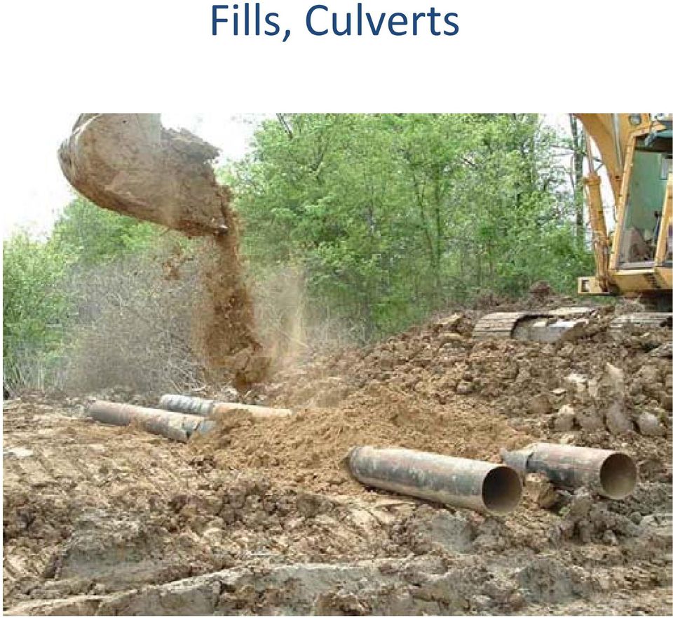
5 Fills, Culverts
6 Channelization

7 Why Be Concerned About Floodplain Natural and Beneficial Functions in Flood Loss Reduction Programs? 1. Development in flood hazards is damaged by flooding increasing public and private flood losses. 2. Development in these areas increases flood hazards on adjacent, upstream, and downstream properties and this often results in disputes between landowners and lawsuits. 3. Flood plains and the wetlands and riparian areas often provide important flood loss reduction functions. 4. Floodplains provide in their own right a broad range of other functions and values to society.

8 1. Floodplain Wetlands And Riparian Areas Are Subject To A Variety Of Flood And Erosion related related Hazards. Reducing Development In These Areas Reduces Hazard Losses and, Simultaneously, Protects a Variety of Functions and Values Inland Flooding Due to Runoff Inland Floodingand Basement FloodingDue to Long Term Fluctuations in Ground Water Levels Erosion Coastal/Estuarine/InlandWave Action Storm Surge (Coastal and Estuarine) Liquefaction Subsidence Earthquake Wave Propagation Floodingand Hydrostatic Pressures
 Liquefaction Subsidence Earthquake Wave Propagation")
9 1. Floodplain Wetlands And Riparian Areas Are Subject To A Variety Of Flood And Erosion related related Hazards. Reducing Development In These Areas Reduces Hazard Losses and, Simultaneously, Protects a Variety of Functions and Values Inland Flooding Due to Runoff Inland Floodingand Basement FloodingDue to Long Term Fluctuations in Ground Water Levels Erosion Coastal/Estuarine/InlandWave Action Storm Surge (Coastal and Estuarine) Liquefaction Subsidence Earthquake Wave Propagation Floodingand PressureDamage FromHydrostatic Pressures
 Liquefaction Subsidence Earthquake Wave Propagation")
10 Hydrostatic Pressures

11 2. Flood plains and the wetlands and riparian areas provide important flood loss reduction functions. 1. Wave attenuation and erosion control 2. Storm surge and tsunami reduction 3. Flood conveyance 4. Flood storage

12 Wave Attentuation and Erosion Control. A Band of Floodplain Vegetation May Cause Waves to Break by Increasing Friction and Absorbing Energy

13 Hurricane Camille, Foot Storm Surge and Waves

14
15 Extensive Wetlands Reduce Surge and Tsunami Elevations. 1 Foot per 1.0 to 2.7 Miles of Wetland

16 December, 2004 South Asian Tsunami

17 Flood Conveyance (Zero Rise Floodway in Tulsa) Tl

18

19

20 3. Development in flood areas increases flood hazards on adjacent, upstream, and downstream properties p and this results in disputes between landowners and lawsuits.

21 The lawyers are, of course, waiting to help you.
22 4. Floodplains Provide A Variety of Other Natural and Beneficial Functions Wave reduction. Flood storage. Flood conveyance. Erosion control. Habitat for fish, shellfish, waterfowl, many types of endangered species. Sediment reduction in lakes, reservoirs, streams, estuaries, and coastal systems. Pollution prevention and treatment: prevent pollution from entering a water body. treat (remove) pollution in a water body. Natural crops and timber: cranberry, blueberry, saltmarsh hay, aquaculture species, wild rice, forestry, other natural crops. Groundwater recharge.
23 Scenic beauty, aesthetics. Recreational opportunities, ecotourism. Historical, i archaeological, l heritage, and cultural l opportunities. Education and research. Trapping of carbon, carbon stores important to moderation of global warming. Micro climate modification.
24 Protect Floodplain Natural and Beneficial Functions While Reducing Flood Losses: Will The Twain Ever Meet? Floodplain managersaretypically are engineers and water resource planners; wetland managers are biologists and botanists. The two groups have different vocabularies, interests, and drinking habits. Management practices sometimes conflict. For example, fill is often used in floodplains to reduce flood losses by elevating houses, roads, other activities. But fill also destroys wetlands and broader aquatic ecosystems.
25 Make Protection of Natural and Beneficial Functions an Explicit itgoal
26 Address Erosion as Well as Flooding
27 Put NonStructural Floodplain Management Projects on An Equal Footing With ihstructural Projects
28 Undertake Multiobjective Pre flood Planning With Protection of Natural and Beneficial Functions As One Component
29
30 Undertake Post Disaster Response Reflecting Natural And dbeneficial i lfunctions
31 Lower National Flood Insurance Rates for Communities Which Protect Natural and Beneficial Functions Pursuant to the Community Rating System
32 Acquire Wetlands and Floodplains As Flood Storage And Conveyance Areas: Example: Charles River Wtl Wetland dacquisition iti
33 Clear Structures in Floodways, Floodplains to Reduce Flood Losses, Protect tnt Natural and Beneficial i lfunctions
34 Integrate Wetlands, Riparian Areas Into Flood Control lprojects
35 Create Multiobjective Greenways For Floodplain, Wetland, Riparian Areas
36 Construct Setback Levees
37 Create Habitat Restoration Beads Along Rivers
38 Provide More Accurate Floodplain Maps Reflecting the Full Range of Hazards (e.g., Erosion) andhazardfactors (e.g., Watershed Development, Erosion, Waves, Climate Change.)
39 Restore Floodplains, Wetlands and Riparian Areas to Reduce Flood/Erosion Losses, Restore Natural and Beneficial Functions
40 Adopt Local Setbacks, Buffers, Conservancy Zoning As Part of Comprehensive Planning, Smart Growth, Green Infrastructure Initiatives
41 Strengthen Floodplain Regulations Strengthen the ecologicalelementelement offloodplain floodplain regulatory permitting Tightly regulate fills Adopt a no adverse impact standard for floodplain regulations Adopt zero rise floodways; y; reflect storage in flood calculations Protect wetlands and riparian areas
42 SUMMARY: NEEDED FOR MULTIOBJECTIVE, MORE INTEGRATED APPROACHES Require: Creative out of the box thinking Willingness to go beyond FEMA minimum standards Multiobjective planning and management Building upon and utilizing floodplain, wetland and riparian natural and beneficial functions in projects Multi agency and multi group involvement Communication and cooperation
43 Thanks! Assessing the Natural and Beneficial Functions of Floodplains Report available at: pdf
Flood Risk Management
 Flood Risk Management Value of Flood Risk Management Every year floods sweep through communities across the United States taking lives, destroying property, shutting down businesses, harming the environment
Flood Risk Management
 Flood Risk Management Value of Flood Risk Management Value to Individuals and Communities Every year floods sweep through communities across the United States taking lives, destroying property, shutting
Lower Raritan Watershed Management Area Stormwater & Flooding Subcommittee Strategy Worksheet LRSW-S3C1
 Strategy Name: Reduce Existing Potential for Flood Damages LRSW-S3C1. Develop and implement a program to: Minimize flood damages through the use of structural measures. Minimize flood damages through the
RE: Docket # COE 2010 0035; ZRIN 0710 ZA05 Submitted via email to [email protected] and Rulemaking Portal at www.regulations.gov.
 April 18, 2011 U.S. Army Corps of Engineers Attn: CECW CO R 441 G Street, N.W. Washington, DC 20314 1000 RE: Docket # COE 2010 0035; ZRIN 0710 ZA05 Submitted via email to [email protected] and Rulemaking
ECONOMIC ANALYSIS FLOOD DAMAGE REDUCTION. Lower Carmel River Floodplain Restoration and Enhancement Project
 ECONOMIC ANALYSIS FLOOD DAMAGE REDUCTION Lower Carmel River Floodplain Restoration and Enhancement Project I. Description of the Project and its Relationship to Other Projects in the Proposal The Lower
3. The submittal shall include a proposed scope of work to confirm the provided project description;
 QIN Shoreline Master Program Project Summary The Shoreline Master Program (SMP) development process for the Quinault Indian Nation (QIN) includes the completion of inventory and analysis report with corresponding
Applying HUD s Floodplain Management and Wetlands Protection Standards U.S. Department of Housing and Urban Development Office of Environment and
 Applying HUD s Floodplain Management and Wetlands Protection Standards U.S. Department of Housing and Urban Development Office of Environment and Energy Executive Order 11988 Floodplain Management Training
Ecosystem Services in the Greater Houston Region. A case study analysis and recommendations for policy initiatives
 Ecosystem Services in the Greater Houston Region A case study analysis and recommendations for policy initiatives Ecosystem Services Ecosystems provide services through their natural processes that we
Community Workshop 5. Overarching Goals for Machado Lake Ecosystem and Wilmington Drain Multi-Use Projects
 City of Los Angeles Department of Public Works Bureau of Engineering Machado Lake Ecosystem Rehabilitation Project & Wilmington Drain Multi-Use Project Community Workshop 5 February 24, 2009 In association
Henry Van Offelen Natural Resource Scientist MN Center for Environmental Advocacy [email protected]
 Henry Van Offelen Natural Resource Scientist MN Center for Environmental Advocacy [email protected] Wetland study slide Water Quality NRE goals in watershed plans Protect habitat that remains.
Develop hazard mitigation policies and programs designed to reduce the impact of natural and human-caused hazards on people and property.
 6.0 Mitigation Strategy Introduction A mitigation strategy provides participating counties and municipalities in the H-GAC planning area with the basis for action. Based on the findings of the Risk Assessment
Wetland Vocabulary Organizer
 Wetland Vocabulary Organizer Vocabulary Word Definition Wetland Picture Species Nutrients Sediment Groundwater Habitat Vocabulary Word Wetland Wetland Vocabulary Organizer Key Definition is an area that,
Rhode Island NRCS received approximately $2.4 million in ARRA funds to implement four floodplain easement projects.
 American Recovery and Reinvestment Act (ARRA) Emergency Watershed Protection Program Floodplain Easements Rhode Island Natural Resources Conservation Service Rhode Island NRCS received approximately $2.4
The answers to some of the following questions are separated into two major categories:
 Following the recent flooding events for Front Range communities in Colorado, property owners, communities, and the National Flood Insurance Program are being presented with some new challenges in the
Wetlands and Climate Change: Considerations for Wetland Program Managers
 Wetlands and Climate Change: Considerations for Wetland Program Managers Association of State Wetland Managers July 2015 1 Wetlands and Climate Change: Considerations for Wetland Program Managers Association
Backyard Buffers that Work for People and Nature by Restoring Ecological Function
 Backyard Buffers that Work for People and Nature by Restoring Ecological Function What is a Wetland Buffer? A wetland buffer is a simple land management practice that is employed by municipalities to protect
Goal 1 To protect the public health, safety and property from the harmful effects of natural disasters.
 Plan Framework for Coastal Management The purpose of this element is to provide for the protection of residents and property in within the coastal area of the host community, and to limit expenditures,
FLOOD PROTECTION AND ECOSYSTEM SERVICES IN THE CHEHALIS RIVER BASIN. May 2010. Prepared by. for the. 2010 by Earth Economics
 FLOOD PROTECTION AND ECOSYSTEM SERVICES IN THE CHEHALIS RIVER BASIN May 2010 Prepared by for the Execubve Summary The Chehalis Basin experienced catastrophic flooding in 2007 and 2009. In response, the
Urban Stream Restoration Defining the Full Benefits of a Project. Warren C. High MACTEC Engineering and Consulting
 Urban Stream Restoration Defining the Full Benefits of a Project Warren C. High MACTEC Engineering and Consulting Economics in the Decision Process Return on Investment Willingness to Pay Municipal Growth
The Basics of Chapter 105 Waterways and Wetlands Permitting in PA
 The Basics of Chapter 105 Waterways and Wetlands Permitting in PA April 17, 2013 Goal To develop a basic understanding of PA Department of Environmental Protection (DEP) and US Army Corps of Engineers
Post-Flood Assessment
 Page 1 of 7 Post-Flood Assessment CHAPTER 4 AGENCY COORDINATION Agency coordination is an essential element for the operation of the flood management systems in the Central Valley. Due to the nature of
MITIGATION STRATEGY OVERVIEW
 ALL-HAZARDS MITIGATION PLAN MITIGATION STRATEGY Code of Federal Regulations (CFR) Requirement 44 CFR Part 201.6(c)(3)(i): The mitigation strategy shall include a description of mitigation goals to reduce
New York Sea Grant Strategic Plan
 New York Sea Grant Strategic Plan Introduction and Process This is the new strategic plan for New York Sea Grant (NYSG) for the years 2010-2013 as requested by the National Sea Grant Office. This plan
Why should communities invest in resiliency? What are the steps communities can take to become more resilient?
 Community Preparedness for Flood Resiliency Nina Peek, AICP New York Planning Federation Board of Directors Senior Technical Director AKRF, Inc. Focus of Today s Presentation Why should communities invest
What We Do: Wetlands, Wildlife Habitat & Flood Hazards in the Root River Watershed
 What We Do: Wetlands, Wildlife Habitat & Flood Hazards in the Root River Watershed presented by Ceil Strauss, State Floodplain Manager DNR Ecological & Water Resources 1 EWR Roles In Floodplains Regulatory:
RESTORING streams to reduce flood loss
 RESTORING streams to reduce flood loss Flood Loss Reduction the Natural Way Flood disasters have become a regular Floods can devastate local occurrence. One in your community may have communities. threatened
AN INITIATIVE TO IMPROVE
 L OW E R C A R M E L R I V E R A N D L AG O O N F L O O D P L A I N R E S TO R AT I O N A N D E N H A N C E M E N T P R O J E C T AN INITIATIVE TO IMPROVE FLOOD PROTECTION RESTORE AND PROTECT RIPARIAN
Saving Constituents Money on Flood Insurance Under FEMA s Community Rating System (CRS)
") Saving Constituents Money on Flood Insurance Under FEMA s Community Rating System (CRS) Today s Discussion 1. FEMA s Flood Insurance Program: A Brief Overview 2. Flood Insurance Rates: Are they rising?
Saving Constituents Money on Flood Insurance Under FEMA s Community Rating System (CRS) Today s Discussion 1. FEMA s Flood Insurance Program: A Brief Overview 2. Flood Insurance Rates: Are they rising?
A Self Assessment to Address Climate Change Readiness in Your Community Midwest Region
 A Self Assessment to Address Climate Change Readiness in Your Community Midwest Region 0 Climate Change Readiness Index A Self Assessment to Address Climate Change Readiness in Your Community Communities
Addendum D. Nomination of Moody Wash ACEC
 Addendum D Nomination of Moody Wash ACEC Moody Wash ACEC is hereby nominated by Citizens for Dixie s Future to: BLM St. George Field Office 345 East Riverside Drive St. George, UT 84790 Moody Wash is a
Oregon. Climate Change Adaptation Framework
 Oregon Climate Change Adaptation Framework Oregon Environmental Quality Commission Climate Change Adaptation Framework Presentation at a glance: Purposes of the framework Participating agencies Climate
Regulatory Features of All Coastal and Inland Ecological Restoration Limited Projects
 Eligibility Checklist This Ecological Restoration Limited Project Eligibility Checklist guides the applicant in determining if their project is eligible to file as an Inland or Coastal Ecological Restoration
COMMUNITY CERTIFICATIONS
 National Flood Insurance Program Community Rating System COMMUNITY CERTIFICATIONS Public reporting burden for this form is estimated to average 4 hours for annual recertification, per response. The burden
Section 4 General Strategies and Tools
 Section 4 General Strategies and Tools Key planning issues for WRIA 35 have been identified in Sections 5 and 6 in the areas of water supply, instream flow, water quality, and aquatic habitat. General
How To Plan A Buffer Zone
 Backyard Buffers Protecting Habitat and Water Quality What is a buffer? A buffer (also called a riparian buffer area or zone) is the strip of natural vegetation along the bank of a stream, lake or other
How To Amend A Stormwater Ordinance
 Regulatory Alternatives to Address Stormwater Management and Flooding in the Marlboro Street Study Area Alternative 1: Amend Existing Local Regulations This proposed alternative provides an incremental
A Developer s Guide: Watershed-Wise Development
 A Developer s Guide: Watershed-Wise Development Environmental Protection What is a watershed? It does not matter how far away you build from a creek, lake, or the ocean, you are in a watershed. Another
MASSACHUSETTS COASTAL NONPOINT PROGRAM NOAA/EPA DECISIONS ON CONDITIONS OF APPROVAL
 MASSACHUSETTS COASTAL NONPOINT PROGRAM NOAA/EPA DECISIONS ON CONDITIONS OF APPROVAL FOREWORD This document contains the basis for NOAA and EPA s decision to fully approve Massachusetts Coastal Nonpoint
Lower Crooked Creek Watershed Conservation Plan EXECUTIVE SUMMARY
 EXECUTIVE SUMMARY Project Background Located in southwestern Pennsylvania, Crooked Creek is a major tributary of the Allegheny River, entering near Ford City in Armstrong County. It is rich in natural
DRAFT SOUTH FORK SKYKOMISH RIVER
 DRAFT SOUTH FORK SKYKOMISH RIVER 9 levees and revetments / Approximately 1.1 miles of river bank are armored Revetments provide limited, localized erosion protection, but impact habitat Frequent and costly
Future of our coasts: Potential for natural and hybrid infrastructure to enhance ecosystem and community resilience Ariana Sutton-Grier
 Future of our coasts: Potential for natural and hybrid infrastructure to enhance ecosystem and community resilience Ariana Sutton-Grier University of Maryland & National Oceanic and Atmospheric Administration
Environmental Case Study Decatur, Georgia, DeKalb County A Suburban Creek Resists Channelization
 Introduction A visual examination of Doolittle Creek in a highly developed suburban county in Georgia yielded telltale signs of a creek whose original streambed had been altered. Examination of official
Revising the Nantahala and Pisgah Land Management Plan Preliminary Need to Change the Existing Land Management Plan
 Revising the Nantahala and Pisgah Land Management Plan Preliminary Need to Change the Existing Land Management Plan Throughout the Plan 1. There is a fundamental need for the revised plan to address how
4. Environmental Impacts Assessment and Remediation Targets
 4. Environmental Impacts Assessment and Remediation Targets 4.1 Environmental Impacts Significant additional development in the Alder Creek watershed is not anticipated at this time; however, there are
Miquon Creek STREAM RESTORATION PROJECT WHO WE ARE
 Miquon Creek STREAM RESTORATION PROJECT WHO WE ARE Introductions Brett Long, PE Project Permitting & Construction Oversight Chris Streb, PE Project Designer & Construction Oversight Assistance WHO WE ARE
3.4 DRAINAGE PLAN. 3.4.1 Characteristics of Existing Drainages. 3.4.2 Master Drainage System. Section 3: Development Plan BUTTERFIELD SPECIFIC PLAN
 3.4 DRAINAGE PLAN This section describes the existing onsite drainage characteristics and improvements proposed within this Specific Plan. Following this description, drainage plan development standards
Greater Los Angeles County Region
 Attachment 6 Greater Los Angeles County Region IRWM Implementation Grant Proposal Monitoring, Assessment, and Attachment 6 consists of the following items: Monitoring, Assessment, and. The purpose of this
1 Introduction. 1.1 Key objective. 1.2 Why the South Esk
 1 Introduction 1.1 Key objective The aim of this study is to identify and assess possible options for improving the quality of the river channel and habitats in the River South Esk catchment whilst helping
Flooding Hazards, Prediction & Human Intervention
 Page 1 of 10 EENS 3050 Tulane University Natural Disasters Prof. Stephen A. Nelson Flooding Hazards, Prediction & Human Intervention This page last updated on 19-Oct-2015 Hazards Associated with Flooding
Clean Water Services. Ecosystems Services Case Study: Tualatin River, Washington
 Viewed broadly, the concept of ecosystem services describes the many resources and services provided by nature. Typically, traditional planning and development practices do not adequately represent the
Appendix J Online Questionnaire
 Appendix J Online Questionnaire In accordance with the Paperwork Reduction Act, this questionnaire was approved by the Office of Management and Budget (OMB). The OMB control number and expiration date
Napa River Restoration Projects
 Napa River Restoration Projects Shaun Horne, Napa County, [email protected] Jeremy Sarrow, Napa County, [email protected] The Napa River flows though one of the most scenic landscapes
Carlton Fields Memorandum
 Carlton Fields Memorandum TO: FROM: RE: DAN WEEDE FRED RUSHING RIPARIAN BUFFER DATE: JULY 26, 2013 BACKGROUND Both the state of Georgia and the city of Atlanta 1 have certain guidelines that must be followed
NYSDEC Optional Additional Language Model Local Law for Flood Damage Prevention Optional Additional Language
 NYSDEC General Comments. The contains language that complies with the floodplain management requirements of the National Flood Insurance Program (NFIP) contained in federal regulations 44 CFR 60.3 through
CWSRF Project Descriptions and Examples for Green Project Reserve
 CWSRF Project Descriptions and Examples for Green Project Reserve I. Water Efficiency a. Water efficiency is the use of improved technologies and practices to deliver equal or better services with less
ANGORA FIRE RESTORATION PROJECT
 ANGORA FIRE RESTORATION PROJECT U.S. Forest Service LAKE TAHOE BASIN MANAGEMENT UNIT Duncan Leao Vegetation Management Planner Richard Vacirca Forest Aquatics Biologist 3 PHASES OF FIRE REHAB Phase I Rehab:
Building Resilient Infrastructure for the 21 st Century
 Building Resilient Infrastructure for the 21 st Century 1 Maria Mehranian Cordoba Corporation & Los Angeles Regional Water Quality Control Board October 19, 2014 24 th Annual Lake Arrowhead Symposium:
Restoring Ecosystems. Ecosystem Restoration Services
 Restoring Ecosystems Ecosystem Restoration Services 2 Ecosystem Restoration Services AECOM s integrated approach sciencebased planning, with innovative design and execution delivers sustainable and cost-effective
Appendix H Dredging and Stream Channel Restoration
 Appendix H Dredging and Stream Channel Restoration Mankind s intrusion into the natural environment in West Virginia began in earnest following the Civil War when extractive industries and settlement all
Shoreline Master Programs Handbook Chapter 15, Shoreline Stabilization
 Shoreline Master Programs Handbook Chapter 15, Shoreline Stabilization Publication Number: 11-06-010 7/15 Contents Introduction... 1 Chapter overview... 2 Description of shoreline stabilization... 2 Design
General Permit for Activities Promoting Waterway - Floodplain Connectivity [working title]
![General Permit for Activities Promoting Waterway - Floodplain Connectivity [working title]](/thumbs/39/18645965.jpg "General Permit for Activities Promoting Waterway - Floodplain Connectivity [working title]") General Permit for Activities Promoting Waterway - Floodplain Connectivity [working title] Purpose These rules set forth the conditions under which a person may, without an individual removal-fill permit
General Permit for Activities Promoting Waterway - Floodplain Connectivity [working title] Purpose These rules set forth the conditions under which a person may, without an individual removal-fill permit
The Teton Creek Restoration Project Summary:
 The Teton Creek Restoration Project Summary: The Teton Creek Restoration Project area extends for approximately one mile upstream from the Cemetery Road Bridge and includes the Aspen Pointe, The Aspens
Passive Restoration 101: Framework and Techniques Overview. Amy Chadwick, Great West Engineering August 26, 2015 Butte, America
 Passive Restoration 101: Framework and Techniques Overview Amy Chadwick, Great West Engineering August 26, 2015 Butte, America What Defines Passive Restoration? Process-based, nature-driven Minimal equipment
1.7.0 Floodplain Modification Criteria
 1.7.0 Floodplain Modification Criteria 1.7.1 Introduction These guidelines set out standards for evaluating and processing proposed modifications of the 100- year floodplain with the following objectives:
APPENDIX A: STORMWATER MANAGEMENT CHECKLIST
 APPENDIX A: STORMWATER MANAGEMENT CHECKLIST The first thing that applicants and designers must do before beginning a project is to make sure they are familiar with the 11 minimum standards listed in Manual
GLOSSARY OF TERMS CHAPTER 11 WORD DEFINITION SOURCE. Leopold
 CHAPTER 11 GLOSSARY OF TERMS Active Channel The channel that contains the discharge Leopold where channel maintenance is most effective, sediment are actively transported and deposited, and that are capable
SKAGIT COUNTY HABITAT IMPROVEMENT PLAN
 SKAGIT COUNTY HABITAT IMPROVEMENT PLAN Public Works Department Natural Resources Division August 2012 Mission To create and advance restoration strategies that support Skagit County goals for promoting
Chapter 6: Mitigation Strategies
 Chapter 6: Mitigation Strategies This section of the Plan describes the most challenging part of any such planning effort the development of a Mitigation Strategy. It is a process of: 1. Setting mitigation
Restoring and protecting natural floodplains reduces flood losses and benefits the environment. Photo: USDA NRCS.
 The Multiple Benefits of Floodplain Easements: An Assessment of American Recovery and Reinvestment Act-Funded Emergency Watershed Protection Program Floodplain Easements in the Upper Mississippi River
Existing Land Use Map
 ilsonmiller, nc. does not warrant data provided by other sources for accuracy or property appraisal, survey, or for zoning verification. ilsonmiller, nc. has not verified this data for accuracy nor has
Remaining Wetland Acreage 1,500,000 915,960 584,040-39%
 NEW JERSEY Original Wetland Acreage Remaining Wetland Acreage Acreage Lost % Lost 1,500,000 915,960 584,040-39% New Jersey Wetlands: Nearly 99 percent of New Jersey s wetlands are palustrine or estuarine.
Markets for Ecosystem Services on Agricultural Lands: Experience and Outlook in the United States
 Markets for Ecosystem Services on Agricultural Lands: Experience and Outlook in the United States Frank Casey Conservation Economics and Finance Program Defenders of Wildlife Presented at the Biodiversity
NEW BRUNSWICK DEPARTMENT OF SUPPLY AND SERVICES EEL RIVER DAM REMOVAL/ DECOMMISSIONING PROJECT
 NEW BRUNSWICK DEPARTMENT OF SUPPLY AND SERVICES EEL RIVER DAM REMOVAL/ DECOMMISSIONING PROJECT August 2006 Prepared by: NB Department of Environment Environment 1. INTRODUCTION This General Review Statement
Stream Rehabilitation Concepts, Guidelines and Examples. Objectives. Pierre Y. Julien. Three Laws of Stream Restoration
 Stream Rehabilitation Concepts, Guidelines and Examples Pierre Y. Julien Wuhan 2005 Objectives Part I - Stream restoration and rehabilitation: 1. Present and discuss important concepts, laws, criteria
 Coldwater Heritage Partnership Implementation Grant Final Report Morrison Run Watershed Restoration Project Western Pennsylvania Conservancy Project Summary The goal of the Morrison Run Watershed Restoration
5.0 OVERVIEW OF FLOOD DAMAGE REDUCTION MEASURES
 5.0 OVERVIEW OF FLOOD DAMAGE REDUCTION MEASURES Flood damage reduction consists of two basic techniques structural and non-structural. Structural methods modify the flood and take the flood away from people
REFERENCE. All National Grid personnel who plan and perform work involving protected water resources are responsible for:
 EG-30NY ENVIRONMENTAL GUIDANCE PAGE 1 of 9 DATE 10/1/10 EP 3 Natural Resource Protection 1.0 SCOPE AND RESPONSIBILITIES National Grid s New York service territory encompasses thousands of wetlands, lakes,
Improving the physical condition of Scotland s water environment. A supplementary plan for the river basin management plans
 Improving the physical condition of Scotland s water environment A supplementary plan for the river basin management plans Contents Executive summary... 2 1. Introduction... 3 2. Vision... 4 3. Taking
7.0 Stream Restoration
 7.0 Stream Restoration 7.1 Issue Statements One of the primary concerns of residents in the Bassett Creek watershed is the maintenance of the natural beauty of the creek in residential and recreational
King County, Washington Policies and Practice for the Use of Eminent Domain For Flood Risk Reduction
 King County, Washington Policies and Practice for the Use of Eminent Domain For Flood Risk Reduction Introduction Eminent domain refers to the power possessed by the state over all property within the
Restoration Planning and Development of a Restoration Bank
 Restoration Planning and Development of a Restoration Bank Black Creek Pioneer Village, South Theatre 8:30 a.m. to 3:30 p.m. Habitat Restoration and Environmental Monitoring Projects Section Restoration
HCP Team Meeting. November 18, 2015. icfi.com
 HCP Team Meeting November 18, 2015 icfi.com 1 Welcome and Introductions Where are we in the HCP process Hydrology modeling update Native fish survey Fish translocation Finalize covered activities Next
Risk Analysis, GIS and Arc Schematics: California Delta Levees
 Page 1 of 7 Author: David T. Hansen Risk Analysis, GIS and Arc Schematics: California Delta Levees Presented by David T. Hansen at the ESRI User Conference, 2008, San Diego California, August 6, 2008 Abstract
Gold Ray Dam Interagency Technical Team Meeting
 Gold Ray Dam Interagency Technical Team Meeting Agenda Public Outreach, Funding, Monitoring EA/BA/Permit Updates Deconstruction Plans Fish Passage & Salvage Plan Hydraulic Modeling Next Steps Public Outreach,
Flood Plain Reclamation to Enhance Resiliency Conserving Land in Urban New Jersey
 Flood Plain Reclamation to Enhance Resiliency Conserving Land in Urban New Jersey Rutgers Cooperative Extension Water Resources Program Christopher C. Obropta, Ph.D., P.E. Email: [email protected]
$200 Billion. Ecosystem Services: The Gridlock Breaker. Four Types of Capital. Built Capital Social Capital Human Capital Natural Capital
 Ecosystem Services: The Gridlock Breaker Four Types of Capital A session of the 2012 Washington State APA Conference Olympia, Washington 0ctober 12, 2012 Doug Osterman, Steve Hughes Tracy Stanton, Dave