Ocean Processes I Oceanography Department University of Cape Town South Africa
|
|
|
- Sara Blair
- 7 years ago
- Views:
Transcription
1 Ocean Processes I Isabelle.Ansorge@uct.ac.za Oceanography Department University of Cape Town South Africa 1
2 9/17/2009 Lecturer in Oceanography at UCT About me! BSc in England University of Plymouth MSc and PhD University of Cape Town Sea-going Oceanographer Southern Ocean projects Currently interested in ocean eddy heat fluxes from the Antarctic to the Subantarctic 2
3 9/17/2009 Train our postgraduate students at sea 3
4 4
5 ..Ocean Physics outline Wind driven ocean circulation Connecting to the deep and the importance of the oceans and small scale processes in a changing planet II I Two types of Ocean Circulation: 5
6 The Shallow, Swift Wind-driven Circulation The Slow, Deep Thermohaline Circulation Antarctic Circumpolar Wind driven surface circulation Learning Objectives The role of solar heating How does the wind drive surface currents? Consider this! Theories from Ekman, Stommel West vs East why the difference Coastal and open ocean upwelling 6
7 What regulates the motion of fluid particles in the ocean and atmosphere? Forces generating currents Internal Forces External Forces Forces exerted by wind, thermohaline (TSp) Pressure gradient solar radiation. Tidal forces Forces retarding currents Friction..just to recap.. what drives ocean currents? Two external forces influence the World Ocean generating ocean currents - gravitation and the energy flux from the sun. Gravitation includes tidal forces resulting from the interaction of water mass with the moon and the sun, and rotation of the Earth. IoE The Basics of Satellite Oceanography. 1. The Basic Concepts of Oceanography 7
8 The radiation flux from the sun results in wind stress, heating and cooling of the ocean surface. A complex process of interaction between these forces results in a complex and variable pattern of ocean circulation. IoE The Basics of Satellite Oceanography. 1. The Basic Concepts of Oceanography 1. What drives ocean currents? Solar heating is different at different latitudes, because equal amounts of sunlight are spread over a greater surface area near the poles than in the tropics. 8
9 Simplified!! Warm air rises and cool air sinks; a convection current forms in a room resulting from uneven heating and cooling. Equator South Pole Simplified!! Warm air rises and cool air sinks; a convection current forms in a room resulting from uneven heating and cooling. 9
10 surface Equator/Tropics Higher Latitudes surface Equator/Tropics Higher Latitudes 10
11 Vertical view of the atmosphere Polar Cell Ferrel Cell Equator Pole v 11
12 ..so that s the role of solar heating covered BUT 12
13 How do we get to this?.importance of coriolis force.. Two important reasons: (1) the Earth rotates eastwards (2) the velocity of a point on the Earth is a function of latitude Coriolis parameter f=2ωsin(ø) ω = rotation of earth = 7.292E -5 s -1 The Coriolis deflection is therefore related to the latitude. 13
14 Circumference of the Earth at the Equator = 40,000 kilometers Time to complete one Rotation = 24 hours Speed of Rotation = Distance/Time = 40,000 km / 24 hr = 1670 km/hr Circumference of the Earth at the Equator = 40,000 kilometers Time to complete one Rotation = 24 hours Speed of Rotation = Distance/Time = 40,000 km / 24 hr = 1670 km/hr Circumference of the Earth at 40 N = 30,600 kilometers Time to complete one Rotation = 24 hours Speed of Rotation at 40 North = Distance/Time = 30,600 km / 24 hr = 1280 km/hr 14
15 So we know Changes in latitude affect solar radiation..affects pressure gradients Pressure gradient = winds High to Low Now throw in earths rotation and we have a deflection correlating to the hemisphere. but how do we get the ocean currents? 15
16 Fridtjof Nansen noticed that wind tended to blow ice at an angle of to the right of the wind in the Arctic. Three forces must be important: 1. Wind Stress W; 2. Friction F; 3. Coriolis Force C. and that W + F + C = 0 16
17 Wind stress - the transfer of horizontal momentum. Thus momentum is transferred from the atmosphere to the ocean by wind stress. Wind stress Τ (kg m -1 s -2 or Newton per m 2 ) is an important quantity in the process of wind driving ocean currents. Τ = C d ρ a U 2, where C d is the dimensionless "drag coefficient" of the wind on the surface (about ), ρ a is air density (about 1.3 kg m -2 ), U is wind speed at 10 m above sea level (m s -1 ). Wind stress is a square function of wind speed because the wind forcing depends on wind speed and sea roughness, which in turn accelerates wind speed. 17
18 surface balance between friction and rotation LEFT IN S. HEMISPHERE RIGHT IN N. HEMISPHERE ~100 meter depth But how deep does this extend too?? 18
19 Ekman Layer Depth (D E ) Ekman proposed that the thickness of the Ekman layer depth (at which the current velocity is opposite to the velocity at the surface), occurs at a depth DE Ekman Layer Depth (D E ) Ekman proposed that the thickness of the Ekman layer depth (at which the current velocity is opposite to the velocity at the surface), occurs at a depth DE (m) 19
20 20
21 Horizontal circulation - Ekman drift The wind-driven component of water transport is directed perpendicular to the mean wind stress. The magnitude (kg m -1 s -1 ) is M e = τ / f, where τ is wind stress and f is Coriolis force. 21
22 Effect of Ekman Currents In a nutshell: Wind-driven currents are produced by the interaction between the wind and the water. As wind moves across the water, energy is transferred from the air to the water. - Water moves at about ~3% of the wind speed. Westerly-driven ocean currents in the trade winds, easterly-driven ocean currents in the Westerlies and deflection of the ocean currents by the continents results in a circular current, called an ocean gyre, which occupies most of the ocean basin in each hemisphere. 22
23 So, do the gyres just follow the winds? Not exactly! But the winds get the motion in the ocean started The oceans respond by flowing and turning Water piles up in the center of gyres Productivity varies depends on the physical processes.. 23
24 24
25 Pressure gradients develop in the ocean because the sea surface is warped into broad mounds and depressions with a relief of about 1m. Depressions are caused by divergences, places from where water rises to the surface and flows outward. 25
26 Mounds are caused by convergences, places where water flows together and sinks. 26
27 27
28 Winds at the sea surface drive Ekman transports to the right of the wind in this northern hemisphere example. The converging Ekman transports driven by the trades and westerlies drives a downward geostrophic flow just below the Ekman layer (bold vertical arrows), leading to downward bowing constant density surfaces. 28
29 Application of Ekman Theory coastal Horizontal divergence of the Ekman transports leads to a vertical velocity in the upper boundary layer of the ocean, a process called Ekman Pumping. Levels of nutrients brought to the surface Ekman pumping Wind stress Ekman vertical velocity drives a vertical geostrophic current 29
30 Daily sea surface temperature off Cape Town in summer Coastal Upwelling 30
31 Application of Ekman Theory open ocean 3 cases Application of Ekman Theory open ocean 3 cases 31
32 32
33 Application of Ekman Theory open ocean 3 cases 33
34 Areas of convergence.. here water is moving together and sinking Basically cold dense antarctic waters sink below warm subtropical waters. These convergence zones allow for the NORTHWARD movement of water masses Application of Ekman Theory open ocean 3 cases 34
35 In a non-rotating world this would be our circulation! After Stommel 1948 made the first assumption that coriolis force needs to be included! But the earth rotates! 35
36 Sea surface height 36
37 In an idealised world this mound would be central. BUT rotation of the earth means that the flow is LOP-SIDED!!! 37
38 38
39 39
40 The current flow pattern in gyres is asymmetrical with narrow, deep and swift currents along the basin s western edge and broad, shallow slower currents along the basin s eastern edge. This deflection is called WESTERN INTENSIFICATION The geostrophic mound is deflected to the western part of the ocean basin because of the eastward rotation of the Earth on its axis THIS IS CALLED WESTERN INTENSIFICATION. 40
41 Sea Surface Height see the effects of western boundary currents as high areas!! 41
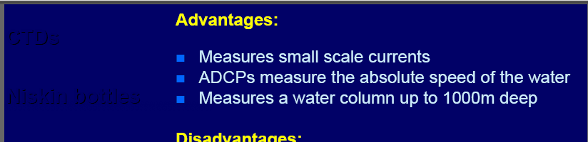
42 So we know Wind effects first observed by Nansen The Ekman layer at the sea surface has the following characteristics: (a) Direction: 45 to the right of the wind looking downwind in the Northern Hemisphere. (b) Surface Speed: 1 3% of wind speed depending on latitude. (c) Depth: approximately m depending on latitude and wind velocity. Ekman pumping, which is driven by spatial variability of winds, drives a vertical current, which drives the interior geostrophic circulation of the ocean. Stommel showed that western boundary currents are required for flow to circulate around an ocean basin when the Coriolis parameter varies with latitude. role of eddies and frontal systems? How do we measure surface? CTD ADCP ARGO floats Drifters Satellite 42
43 43
44 44
45 Horizontal circulation Geostrophic flow Mean dynamic height (m 2 s -2 ), or steric height multiplied by gravity, for the World Ocean at 0 m relative to 2000 m. Arrows indicate the direction of the implied geostrophic movement of water. IoE The Basics of Satellite Oceanography. 1. The Basic Concepts of Oceanography Water at station A is denser than water at station B. As the weight of the water above z = z 0 is the same, the water column must be longer at B than at A. Distribution of isobars and isopycnals at any depth level above z = z 0. In geostrophic flow, water moves along isobars, with the higher pressure on its right in the Northern Hemisphere (away from the equator). IoE The Basics of Satellite Oceanography. 1. The Basic Concepts of Oceanography 45
46 46

47 47
48 48
49 49
50 50
51 Ocean currents can be determined from the slope of the sea surface measured by the satellite altimeter 51
52 52
Chapter Overview. Seasons. Earth s Seasons. Distribution of Solar Energy. Solar Energy on Earth. CHAPTER 6 Air-Sea Interaction
 Chapter Overview CHAPTER 6 Air-Sea Interaction The atmosphere and the ocean are one independent system. Earth has seasons because of the tilt on its axis. There are three major wind belts in each hemisphere.
Lecture 4: Pressure and Wind
 Lecture 4: Pressure and Wind Pressure, Measurement, Distribution Forces Affect Wind Geostrophic Balance Winds in Upper Atmosphere Near-Surface Winds Hydrostatic Balance (why the sky isn t falling!) Thermal
How Do Oceans Affect Weather and Climate?
 How Do Oceans Affect Weather and Climate? In Learning Set 2, you explored how water heats up more slowly than land and also cools off more slowly than land. Weather is caused by events in the atmosphere.
The Oceans Role in Climate
 The Oceans Role in Climate Martin H. Visbeck A Numerical Portrait of the Oceans The oceans of the world cover nearly seventy percent of its surface. The largest is the Pacific, which contains fifty percent
8.5 Comparing Canadian Climates (Lab)
") These 3 climate graphs and tables of data show average temperatures and precipitation for each month in Victoria, Winnipeg and Whitehorse: Figure 1.1 Month J F M A M J J A S O N D Year Precipitation 139
These 3 climate graphs and tables of data show average temperatures and precipitation for each month in Victoria, Winnipeg and Whitehorse: Figure 1.1 Month J F M A M J J A S O N D Year Precipitation 139
Name Period 4 th Six Weeks Notes 2015 Weather
 Name Period 4 th Six Weeks Notes 2015 Weather Radiation Convection Currents Winds Jet Streams Energy from the Sun reaches Earth as electromagnetic waves This energy fuels all life on Earth including the
Dynamics IV: Geostrophy SIO 210 Fall, 2014
 Dynamics IV: Geostrophy SIO 210 Fall, 2014 Geostrophic balance Thermal wind Dynamic height READING: DPO: Chapter (S)7.6.1 to (S)7.6.3 Stewart chapter 10.3, 10.5, 10.6 (other sections are useful for those
Ocean in Motion 2: What Causes Ocean Currents and How Do We Measure Them?
 Ocean in Motion 2: What Causes Ocean Currents and How Do We Measure Them? A. Overview 1. The Ocean in Motion -- Circulation In this program, students will learn about the driving forces responsible for
Chapter 4 Atmospheric Pressure and Wind
 Chapter 4 Atmospheric Pressure and Wind Understanding Weather and Climate Aguado and Burt Pressure Pressure amount of force exerted per unit of surface area. Pressure always decreases vertically with height
Use the following information to deduce that the gravitational field strength at the surface of the Earth is approximately 10 N kg 1.
 IB PHYSICS: Gravitational Forces Review 1. This question is about gravitation and ocean tides. (b) State Newton s law of universal gravitation. Use the following information to deduce that the gravitational
Newton s Law of Gravity
 Gravitational Potential Energy On Earth, depends on: object s mass (m) strength of gravity (g) distance object could potentially fall Gravitational Potential Energy In space, an object or gas cloud has
2. The map below shows high-pressure and low-pressure weather systems in the United States.
 1. Which weather instrument has most improved the accuracy of weather forecasts over the past 40 years? 1) thermometer 3) weather satellite 2) sling psychrometer 4) weather balloon 6. Wind velocity is
ATMS 310 Jet Streams
 ATMS 310 Jet Streams Jet Streams A jet stream is an intense (30+ m/s in upper troposphere, 15+ m/s lower troposphere), narrow (width at least ½ order magnitude less than the length) horizontal current
ATM 316: Dynamic Meteorology I Final Review, December 2014
 ATM 316: Dynamic Meteorology I Final Review, December 2014 Scalars and Vectors Scalar: magnitude, without reference to coordinate system Vector: magnitude + direction, with reference to coordinate system
Lab Activity on Global Wind Patterns
 Lab Activity on Global Wind Patterns 2002 Ann Bykerk-Kauffman, Dept. of Geological and Environmental Sciences, California State University, Chico * Objectives When you have completed this lab you should
Seasonal & Daily Temperatures. Seasons & Sun's Distance. Solstice & Equinox. Seasons & Solar Intensity
 Seasonal & Daily Temperatures Seasons & Sun's Distance The role of Earth's tilt, revolution, & rotation in causing spatial, seasonal, & daily temperature variations Please read Chapter 3 in Ahrens Figure
Hurricanes. Characteristics of a Hurricane
 Hurricanes Readings: A&B Ch. 12 Topics 1. Characteristics 2. Location 3. Structure 4. Development a. Tropical Disturbance b. Tropical Depression c. Tropical Storm d. Hurricane e. Influences f. Path g.
What Causes Climate? Use Target Reading Skills
 Climate and Climate Change Name Date Class Climate and Climate Change Guided Reading and Study What Causes Climate? This section describes factors that determine climate, or the average weather conditions
Geography affects climate.
 KEY CONCEPT Climate is a long-term weather pattern. BEFORE, you learned The Sun s energy heats Earth s surface unevenly The atmosphere s temperature changes with altitude Oceans affect wind flow NOW, you
ES 106 Laboratory # 3 INTRODUCTION TO OCEANOGRAPHY. Introduction The global ocean covers nearly 75% of Earth s surface and plays a vital role in
 ES 106 Laboratory # 3 INTRODUCTION TO OCEANOGRAPHY 3-1 Introduction The global ocean covers nearly 75% of Earth s surface and plays a vital role in the physical environment of Earth. For these reasons,
2. Orbits. FER-Zagreb, Satellite communication systems 2011/12
 2. Orbits Topics Orbit types Kepler and Newton laws Coverage area Influence of Earth 1 Orbit types According to inclination angle Equatorial Polar Inclinational orbit According to shape Circular orbit
What causes Tides? If tidal forces were based only on mass, the Sun should have a tidegenerating
 What are Tides? Tides are very long-period waves that move through the oceans as a result of the gravitational attraction of the Moon and the Sun for the water in the oceans of the Earth. Tides start in
Lecture 3. Turbulent fluxes and TKE budgets (Garratt, Ch 2)
") Lecture 3. Turbulent fluxes and TKE budgets (Garratt, Ch 2) In this lecture How does turbulence affect the ensemble-mean equations of fluid motion/transport? Force balance in a quasi-steady turbulent boundary
Lecture 3. Turbulent fluxes and TKE budgets (Garratt, Ch 2) In this lecture How does turbulence affect the ensemble-mean equations of fluid motion/transport? Force balance in a quasi-steady turbulent boundary
7613-1 - Page 1. Weather Unit Exam Pre-Test Questions
 Weather Unit Exam Pre-Test Questions 7613-1 - Page 1 Name: 1) Equal quantities of water are placed in four uncovered containers with different shapes and left on a table at room temperature. From which
Engaging Students Through Interactive Activities In General Education Classes
 Engaging Students Through Interactive Activities In General Education Classes On the Cutting Edge: Early Career Geoscience Faculty Workshop 14-18 June 2009 Presented by Randy Richardson Department of Geosciences,
Natural Convection. Buoyancy force
 Natural Convection In natural convection, the fluid motion occurs by natural means such as buoyancy. Since the fluid velocity associated with natural convection is relatively low, the heat transfer coefficient
Physics of the Atmosphere I
 Physics of the Atmosphere I WS 2008/09 Ulrich Platt Institut f. Umweltphysik R. 424 Ulrich.Platt@iup.uni-heidelberg.de heidelberg.de Last week The conservation of mass implies the continuity equation:
Section 1 The Earth System
 Section 1 The Earth System Key Concept Earth is a complex system made up of many smaller systems through which matter and energy are continuously cycled. What You Will Learn Energy and matter flow through
TIDES. 1. Tides are the regular rise and fall of sea level that occurs either once a day (every 24.8 hours) or twice a day (every 12.4 hours).
 or twice a day (every 12.4 hours).") TIDES What causes tides? How are tides predicted? 1. Tides are the regular rise and fall of sea level that occurs either once a day (every 24.8 hours) or twice a day (every 12.4 hours). Tides are waves
TIDES What causes tides? How are tides predicted? 1. Tides are the regular rise and fall of sea level that occurs either once a day (every 24.8 hours) or twice a day (every 12.4 hours). Tides are waves
Thought Questions on the Geostrophic Wind and Real Winds Aloft at Midlatitudes
 Thought Questions on the Geostrophic Wind and Real Winds Aloft at Midlatitudes (1) The geostrophic wind is an idealized, imaginary wind that we define at each point in the atmosphere as the wind that blows
Storms Short Study Guide
 Name: Class: Date: Storms Short Study Guide Multiple Choice Identify the letter of the choice that best completes the statement or answers the question. 1. A(n) thunderstorm forms because of unequal heating
SECOND GRADE PLATE TECTONICS 1 WEEK LESSON PLANS AND ACTIVITIES
 SECOND GRADE PLATE TECTONICS 1 WEEK LESSON PLANS AND ACTIVITIES PLATE TECTONIC CYCLE OVERVIEW OF SECOND GRADE VOLCANOES WEEK 1. PRE: Investigating the parts of a volcano. LAB: Comparing the parts of a
Chapter 3: Weather Map. Weather Maps. The Station Model. Weather Map on 7/7/2005 4/29/2011
 Chapter 3: Weather Map Weather Maps Many variables are needed to described weather conditions. Local weathers are affected by weather pattern. We need to see all the numbers describing weathers at many
Noon Sun Angle = 90 Zenith Angle
 Noon Sun Angle Worksheet Name Name Date Subsolar Point (Latitude where the sun is overhead at noon) Equinox March 22 nd 0 o Equinox September 22 nd 0 o Solstice June 22 nd 23.5 N Solstice December 22 nd
6 th Grade Science Assessment: Weather & Water Select the best answer on the answer sheet. Please do not make any marks on this test.
 Select the be answer on the answer sheet. Please do not make any marks on this te. 1. Weather is be defined as the A. changes that occur in cloud formations from day to day. B. amount of rain or snow that
Indian Ocean and Monsoon
 Indo-French Workshop on Atmospheric Sciences 3-5 October 2013, New Delhi (Organised by MoES and CEFIPRA) Indian Ocean and Monsoon Satheesh C. Shenoi Indian National Center for Ocean Information Services
Solar System. 1. The diagram below represents a simple geocentric model. Which object is represented by the letter X?
 Solar System 1. The diagram below represents a simple geocentric model. Which object is represented by the letter X? A) Earth B) Sun C) Moon D) Polaris 2. Which object orbits Earth in both the Earth-centered
Gravitational potential
 Gravitational potential Let s assume: A particle of unit mass moving freely A body of mass M The particle is attracted by M and moves toward it by a small quantity dr. This displacement is the result of
1. The diagram below shows a cross section of sedimentary rock layers.
 1. The diagram below shows a cross section of sedimentary rock layers. Which statement about the deposition of the sediments best explains why these layers have the curved shape shown? 1) Sediments were
Earth in the Solar System
 Copyright 2011 Study Island - All rights reserved. Directions: Challenge yourself! Print out the quiz or get a pen/pencil and paper and record your answers to the questions below. Check your answers with
Name: Period: # Plate Tectonics. Journey to the center of the Earth
 Plate Tectonics Journey to the center of the Earth Use pages 124 129 to answer the following questions. Exploring Inside Earth (p. 125-126) 1. What are the two main types of evidence that Geologist use
GEF 1100 Klimasystemet. Chapter 8: The general circulation of the atmosphere
 GEF1100 Autumn 2015 29.09.2015 GEF 1100 Klimasystemet Chapter 8: The general circulation of the atmosphere Prof. Dr. Kirstin Krüger (MetOs, UiO) 1 Lecture Outline Ch. 8 Ch. 8 The general circulation of
Tides and Water Levels
 Tides and Water Levels What are Tides? Tides are one of the most reliable phenomena in the world. As the sun rises in the east and the stars come out at night, we are confident that the ocean waters will
Exploring Florida: Teaching Resources for Science 1 of 6
 Exploring Florida: Teaching Resources for Science 1 of 6 Tropical Cyclones This document describes tropical cyclones and the dangers they pose to coastal populations. It is intended to help teachers improve
Chapter 6: Cloud Development and Forms
 Chapter 6: Cloud Development and Forms (from The Blue Planet ) Why Clouds Form Static Stability Cloud Types Why Clouds Form? Clouds form when air rises and becomes saturated in response to adiabatic cooling.
Tide - rhythmic oscillation of the ocean surface due to gravitational & centrifugal forces ( inertia ) between the Earth, Moon and Sun.
 between the Earth, Moon and Sun.") Chapter 4: The Changing Level of the Sea Tides Longer Scale Variations Influence on Beaches Tide - rhythmic oscillation of the ocean surface due to gravitational & centrifugal forces ( inertia ) between
Chapter 4: The Changing Level of the Sea Tides Longer Scale Variations Influence on Beaches Tide - rhythmic oscillation of the ocean surface due to gravitational & centrifugal forces ( inertia ) between
Thompson/Ocean 420/Winter 2005 Tide Dynamics 1
 Thompson/Ocean 420/Winter 2005 Tide Dynamics 1 Tide Dynamics Dynamic Theory of Tides. In the equilibrium theory of tides, we assumed that the shape of the sea surface was always in equilibrium with the
Name Class Date. true
 Exercises 131 The Falling Apple (page 233) 1 Describe the legend of Newton s discovery that gravity extends throughout the universe According to legend, Newton saw an apple fall from a tree and realized
CHAPTER 5 Lectures 10 & 11 Air Temperature and Air Temperature Cycles
 CHAPTER 5 Lectures 10 & 11 Air Temperature and Air Temperature Cycles I. Air Temperature: Five important factors influence air temperature: A. Insolation B. Latitude C. Surface types D. Coastal vs. interior
Module 11: The Cruise Ship Sector. Destination #3
 Module 11: The Cruise Ship Sector Destination #3 Cruise Destinations Welcome to your third destination. Use the following resource article to learn about the different oceans and time zones. Seen from
The Ideal Gas Law. Gas Constant. Applications of the Gas law. P = ρ R T. Lecture 2: Atmospheric Thermodynamics
 Lecture 2: Atmospheric Thermodynamics Ideal Gas Law (Equation of State) Hydrostatic Balance Heat and Temperature Conduction, Convection, Radiation Latent Heating Adiabatic Process Lapse Rate and Stability
Chapter 3: Weather Map. Station Model and Weather Maps Pressure as a Vertical Coordinate Constant Pressure Maps Cross Sections
 Chapter 3: Weather Map Station Model and Weather Maps Pressure as a Vertical Coordinate Constant Pressure Maps Cross Sections Weather Maps Many variables are needed to described dweather conditions. Local
FIRST GRADE 1 WEEK LESSON PLANS AND ACTIVITIES
 FIRST GRADE 1 WEEK LESSON PLANS AND ACTIVITIES UNIVERSE CYCLE OVERVIEW OF FIRST GRADE UNIVERSE WEEK 1. PRE: Describing the Universe. LAB: Comparing and contrasting bodies that reflect light. POST: Exploring
Review 1. Multiple Choice Identify the choice that best completes the statement or answers the question.
 Review 1 Multiple Choice Identify the choice that best completes the statement or answers the question. 1. When hydrogen nuclei fuse into helium nuclei a. the nuclei die. c. particles collide. b. energy
Section 4: The Basics of Satellite Orbits
 Section 4: The Basics of Satellite Orbits MOTION IN SPACE VS. MOTION IN THE ATMOSPHERE The motion of objects in the atmosphere differs in three important ways from the motion of objects in space. First,
California Standards Grades 9 12 Boardworks 2009 Science Contents Standards Mapping
 California Standards Grades 912 Boardworks 2009 Science Contents Standards Mapping Earth Sciences Earth s Place in the Universe 1. Astronomy and planetary exploration reveal the solar system s structure,
Basics of weather interpretation
 Basics of weather interpretation Safety at Sea Seminar, April 2 nd 2016 Dr. Gina Henderson Oceanography Dept., USNA ghenders@usna.edu Image source: http://earthobservatory.nasa.gov/naturalhazards/view.php?id=80399,
Celestial Observations
 Celestial Observations Earth experiences two basic motions: Rotation West-to-East spinning of Earth on its axis (v rot = 1770 km/hr) (v rot Revolution orbit of Earth around the Sun (v orb = 108,000 km/hr)
Solar energy and the Earth s seasons
 Solar energy and the Earth s seasons Name: Tilt of the Earth s axis and the seasons We now understand that the tilt of Earth s axis makes it possible for different parts of the Earth to experience different
The concepts developed in this standard include the following: Oceans cover about 70% of the surface of the Earth.
 Name Date Grade 5 SOL 5.6 Review Oceans Made by SOLpass - www.solpass.org solpass100@comcast.net Reproduction is permitted for SOLpass subscribers only. The concepts developed in this standard include
Unit 4 Lesson 2 Plate Tectonics. Copyright Houghton Mifflin Harcourt Publishing Company
 Puzzling Evidence What evidence suggests that continents move? In the late 1800s, Alfred Wegener proposed his hypothesis of continental drift. According to this hypothesis, the continents once formed a
The Celestial Sphere. Questions for Today. The Celestial Sphere 1/18/10
 Lecture 3: Constellations and the Distances to the Stars Astro 2010 Prof. Tom Megeath Questions for Today How do the stars move in the sky? What causes the phases of the moon? What causes the seasons?
Rocks and Plate Tectonics
 Name: Class: _ Date: _ Rocks and Plate Tectonics Multiple Choice Identify the choice that best completes the statement or answers the question. 1. What is a naturally occurring, solid mass of mineral or
How to analyze synoptic-scale weather patterns Table of Contents
 How to analyze synoptic-scale weather patterns Table of Contents Before You Begin... 2 1. Identify H and L pressure systems... 3 2. Locate fronts and determine frontal activity... 5 3. Determine surface
SPEED, VELOCITY, AND ACCELERATION
 reflect Look at the picture of people running across a field. What words come to mind? Maybe you think about the word speed to describe how fast the people are running. You might think of the word acceleration
Step 2: Learn where the nearest divergent boundaries are located.
 What happens when plates diverge? Plates spread apart, or diverge, from each other at divergent boundaries. At these boundaries new ocean crust is added to the Earth s surface and ocean basins are created.
Sun Earth Relationships
 1 ESCI-61 Introduction to Photovoltaic Technology Sun Earth Relationships Ridha Hamidi, Ph.D. Spring (sun aims directly at equator) Winter (northern hemisphere tilts away from sun) 23.5 2 Solar radiation
B) 286 m C) 325 m D) 367 m Answer: B
 286 m C) 325 m D) 367 m Answer: B") Practice Midterm 1 1) When a parachutist jumps from an airplane, he eventually reaches a constant speed, called the terminal velocity. This means that A) the acceleration is equal to g. B) the force of
Practice Midterm 1 1) When a parachutist jumps from an airplane, he eventually reaches a constant speed, called the terminal velocity. This means that A) the acceleration is equal to g. B) the force of
circular motion & gravitation physics 111N
 circular motion & gravitation physics 111N uniform circular motion an object moving around a circle at a constant rate must have an acceleration always perpendicular to the velocity (else the speed would
Review Chapters 2, 3, 4, 5
 Review Chapters 2, 3, 4, 5 4) The gain in speed each second for a freely-falling object is about A) 0. B) 5 m/s. C) 10 m/s. D) 20 m/s. E) depends on the initial speed 9) Whirl a rock at the end of a string
Observed Cloud Cover Trends and Global Climate Change. Joel Norris Scripps Institution of Oceanography
 Observed Cloud Cover Trends and Global Climate Change Joel Norris Scripps Institution of Oceanography Increasing Global Temperature from www.giss.nasa.gov Increasing Greenhouse Gases from ess.geology.ufl.edu
For further information, and additional background on the American Meteorological Society s Education Program, please contact:
 Project ATMOSPHERE This guide is one of a series produced by Project ATMOSPHERE, an initiative of the American Meteorological Society. Project ATMOSPHERE has created and trained a network of resource agents
Figure 1.1 Vector A and Vector F
 CHAPTER I VECTOR QUANTITIES Quantities are anything which can be measured, and stated with number. Quantities in physics are divided into two types; scalar and vector quantities. Scalar quantities have
Chapter 2: Solar Radiation and Seasons
 Chapter 2: Solar Radiation and Seasons Spectrum of Radiation Intensity and Peak Wavelength of Radiation Solar (shortwave) Radiation Terrestrial (longwave) Radiations How to Change Air Temperature? Add
The Atmosphere and Winds
 Oceanography 10, T. James Noyes, El Camino College 8A-1 The Atmosphere and Winds We need to learn about the atmosphere, because the ocean and atmosphere are tightly interconnected with one another: you
TECTONICS ASSESSMENT
 Tectonics Assessment / 1 TECTONICS ASSESSMENT 1. Movement along plate boundaries produces A. tides. B. fronts. C. hurricanes. D. earthquakes. 2. Which of the following is TRUE about the movement of continents?
Solar Flux and Flux Density. Lecture 3: Global Energy Cycle. Solar Energy Incident On the Earth. Solar Flux Density Reaching Earth
 Lecture 3: Global Energy Cycle Solar Flux and Flux Density Planetary energy balance Greenhouse Effect Vertical energy balance Latitudinal energy balance Seasonal and diurnal cycles Solar Luminosity (L)
Earth In Space Chapter 3
 Earth In Space Chapter 3 Shape of the Earth Ancient Greeks Earth casts a circular shadow on the moon during a lunar eclipse Shape of the Earth Ancient Greeks Ships were observed to disappear below the
Southern AER Atmospheric Education Resource
 Southern AER Atmospheric Education Resource Vol. 9 No. 5 Spring 2003 Editor: Lauren Bell In this issue: g Climate Creations exploring mother nature s remote control for weather and Climate. g Crazy Climate
Physics 2A, Sec B00: Mechanics -- Winter 2011 Instructor: B. Grinstein Final Exam
 Physics 2A, Sec B00: Mechanics -- Winter 2011 Instructor: B. Grinstein Final Exam INSTRUCTIONS: Use a pencil #2 to fill your scantron. Write your code number and bubble it in under "EXAM NUMBER;" an entry
ENVIRONMENTAL STRUCTURE AND FUNCTION: CLIMATE SYSTEM Vol. II - Low-Latitude Climate Zones and Climate Types - E.I. Khlebnikova
 LOW-LATITUDE CLIMATE ZONES AND CLIMATE TYPES E.I. Khlebnikova Main Geophysical Observatory, St. Petersburg, Russia Keywords: equatorial continental climate, ITCZ, subequatorial continental (equatorial
TEACHER BACKGROUND INFORMATION THERMAL ENERGY
 TEACHER BACKGROUND INFORMATION THERMAL ENERGY In general, when an object performs work on another object, it does not transfer all of its energy to that object. Some of the energy is lost as heat due to
Notes: Most of the material in this chapter is taken from Young and Freedman, Chap. 13.
 Chapter 5. Gravitation Notes: Most of the material in this chapter is taken from Young and Freedman, Chap. 13. 5.1 Newton s Law of Gravitation We have already studied the effects of gravity through the
Astronomy 110 Homework #04 Assigned: 02/06/2007 Due: 02/13/2007. Name:
 Astronomy 110 Homework #04 Assigned: 02/06/2007 Due: 02/13/2007 Name: Directions: Listed below are twenty (20) multiple-choice questions based on the material covered by the lectures this past week. Choose
Density: Sea Water Mixing and Sinking
 Density: Sea Water Mixing and Sinking Unit: Salinity Patterr~s & the Water Cycle I Grade Level: Middle or High I Time Required: two 45 minute class periods I Content Standard: NSES Physical Science, properties
6. The greatest atmospheric pressure occurs in the 1) troposphere 3) mesosphere 2) stratosphere 4) thermosphere
 troposphere 3) mesosphere 2) stratosphere 4) thermosphere") 1. The best evidence of the Earth's nearly spherical shape is obtained through telescopic observations of other planets photographs of the Earth from an orbiting satellite observations of the Sun's altitude
1. The best evidence of the Earth's nearly spherical shape is obtained through telescopic observations of other planets photographs of the Earth from an orbiting satellite observations of the Sun's altitude
Geodynamics Lecture 2 Kinematics of plate tectonics
 Geodynamics Lecture 2 Kinematics of plate tectonics Lecturer: David Whipp david.whipp@helsinki.fi! 4.9.2013 Geodynamics www.helsinki.fi/yliopisto 1 Goals of this lecture Present the three types of plate
The Dynamic Crust 2) EVIDENCE FOR CRUSTAL MOVEMENT
 EVIDENCE FOR CRUSTAL MOVEMENT") The Dynamic Crust 1) Virtually everything you need to know about the interior of the earth can be found on page 10 of your reference tables. Take the time to become familiar with page 10 and everything
The Dynamic Crust 1) Virtually everything you need to know about the interior of the earth can be found on page 10 of your reference tables. Take the time to become familiar with page 10 and everything
ES Chapter 10 Review. Name: Class: Date: Multiple Choice Identify the choice that best completes the statement or answers the question.
 Name: Class: Date: ES Chapter 10 Review Multiple Choice Identify the choice that best completes the statement or answers the question. 1. Scientists used the pattern of alternating normal and reversed
Plate Tectonics Lab. Continental Drift. The Birth of Plate Tectonics
 Plate Tectonics Lab Continental Drift Take a look at a globe sometime and observe the remarkable fit between South America and Africa. Could they have, in fact, been connected? During the 19th and early
The Gravitational Field
 The Gravitational Field The use of multimedia in teaching physics Texts to multimedia presentation Jan Hrnčíř jan.hrncir@gfxs.cz Martin Klejch martin.klejch@gfxs.cz F. X. Šalda Grammar School, Liberec
The relationships between Argo Steric Height and AVISO Sea Surface Height
 The relationships between Argo Steric Height and AVISO Sea Surface Height Phil Sutton 1 Dean Roemmich 2 1 National Institute of Water and Atmospheric Research, New Zealand 2 Scripps Institution of Oceanography,
Chapter 07 Test A. Name: Class: Date: Multiple Choice Identify the choice that best completes the statement or answers the question.
 Class: Date: Chapter 07 Test A Multiple Choice Identify the choice that best completes the statement or answers the question. 1. An example of a vector quantity is: a. temperature. b. length. c. velocity.
State Newton's second law of motion for a particle, defining carefully each term used.
 5 Question 1. [Marks 20] An unmarked police car P is, travelling at the legal speed limit, v P, on a straight section of highway. At time t = 0, the police car is overtaken by a car C, which is speeding
Coordinate Systems. Orbits and Rotation
 Coordinate Systems Orbits and Rotation Earth orbit. The earth s orbit around the sun is nearly circular but not quite. It s actually an ellipse whose average distance from the sun is one AU (150 million
Physics Midterm Review Packet January 2010
 Physics Midterm Review Packet January 2010 This Packet is a Study Guide, not a replacement for studying from your notes, tests, quizzes, and textbook. Midterm Date: Thursday, January 28 th 8:15-10:15 Room:
When the fluid velocity is zero, called the hydrostatic condition, the pressure variation is due only to the weight of the fluid.
 Fluid Statics When the fluid velocity is zero, called the hydrostatic condition, the pressure variation is due only to the weight of the fluid. Consider a small wedge of fluid at rest of size Δx, Δz, Δs
Practice final for Basic Physics spring 2005 answers on the last page Name: Date:
 Practice final for Basic Physics spring 2005 answers on the last page Name: Date: 1. A 12 ohm resistor and a 24 ohm resistor are connected in series in a circuit with a 6.0 volt battery. Assuming negligible
Stability and Cloud Development. Stability in the atmosphere AT350. Why did this cloud form, whereas the sky was clear 4 hours ago?
 Stability and Cloud Development AT350 Why did this cloud form, whereas the sky was clear 4 hours ago? Stability in the atmosphere An Initial Perturbation Stable Unstable Neutral If an air parcel is displaced
Lift vs. Gravity Questions:
 LIFT vs GRAVITY Sir Isaac Newton, an English scientist, observed the force of gravity when he was sitting under a tree and an apple fell on his head! It is a strong force that pulls everything down toward