LANDSLIDE INVENTORIES IN WASHINGTON STATE: THE PAST, PRESENT, AND FUTURE
|
|
|
- Bartholomew Skinner
- 9 years ago
- Views:
Transcription
1 LANDSLIDE INVENTORIES IN WASHINGTON STATE: THE PAST, PRESENT, AND FUTURE AEG Professional Forum on Landslides February 26-28, 2015 Stephen Slaughter, LEG Hazards geologist Division of Geology and Earth Resources Washington Department of Natural Resources

2 2013 AEG ANNUAL MEETING, SEATTLE Presentation on the deficiencies of the WA landslide database Distribution, metadata, and data quality issues Before meeting, I become the steward of the database Post-meeting: I did not change the database Database required a complete remodel

3 LANDSLIDE HAZARD PROGRAM, TODAY Emergency response Hoquiam 2015, Carlton Complex floods 2014, Oso 2014, Sunset Falls 2014, Whidbey Island 2013

4 LANDSLIDES IN WASHINGTON Landslides are a poorly understood hazard People are surprised by landslides In Washington, average annual loss from landslides is >>$30 million 1997 storm disaster relief ~$150 million 1998 Aldercrest-Banyon, ~$50 million

5 SIGNIFICANT LANDSLIDE EVENTS Storm-related, shallow-landslide , 1984, 1996, 1997, 2006, 2007, 2009, and 2015 Named deep-seated landslides Aldercrest-Banyan, Carlyon Beach, Rock Creek, Ledgewood, Hazel, SR 530 slide, Nile, Sunset Falls

6 WASHINGTON LANDSLIDE INVENTORY

7 LANDSLIDE MAPPING Inventory > Susceptibility > Hazard > Risk Mapping Type Definition 1. Inventory Location and characteristics of existing landslides 2. Susceptibility Location and characteristics of potential landslide; areas with a potential to experience future landslides 3. Hazard Estimated annual probability of a landslide 4. Risk Estimated probability of the occurrence and the probability of the consequence

8 Our earliest searchable landslide inventory database Needle cards

9

10 WHERE ARE THE MAPPED LANDSLIDES? Landslide centroid location by ownership Wilderness [VALUE] % Private lands [VALUE] % DNR managed lands [VALUE] % Other public lands [VALUE] % Tribal lands [VALUE] % City limits [VALUE] % Managed forests, private [VALUE] %
![Private lands [VALUE] % DNR managed lands [VALUE] % Other](/docs-images/44/17012069/images/page_10.jpg "public lands [VALUE] % Tribal lands [VALUE] % City limits")
11 INVENTORY SOURCES >200 sources DNR, forest management companies, USFS, universities, USGS, NPS, etc. Majority of mapping Very different mapping techniques, protocols, validation process, mapping purposes, etc. Division of Geology and Earth Resources dnr.wa.gov/geology

12 PROBLEMS? Initiation date typically a year Resolution not compatible with lidar Did not differentiate mapping method Reconnaissance vs. systematic mapping Updated recently!

13

14 DATABASE TODAY No modifications to the LS database in several years* Spatial, temporal, and data quality is extremely variable Cannot be used with lidar-based susceptibility, hazard, risk mapping Publically available through the DNR Geology Portal

15
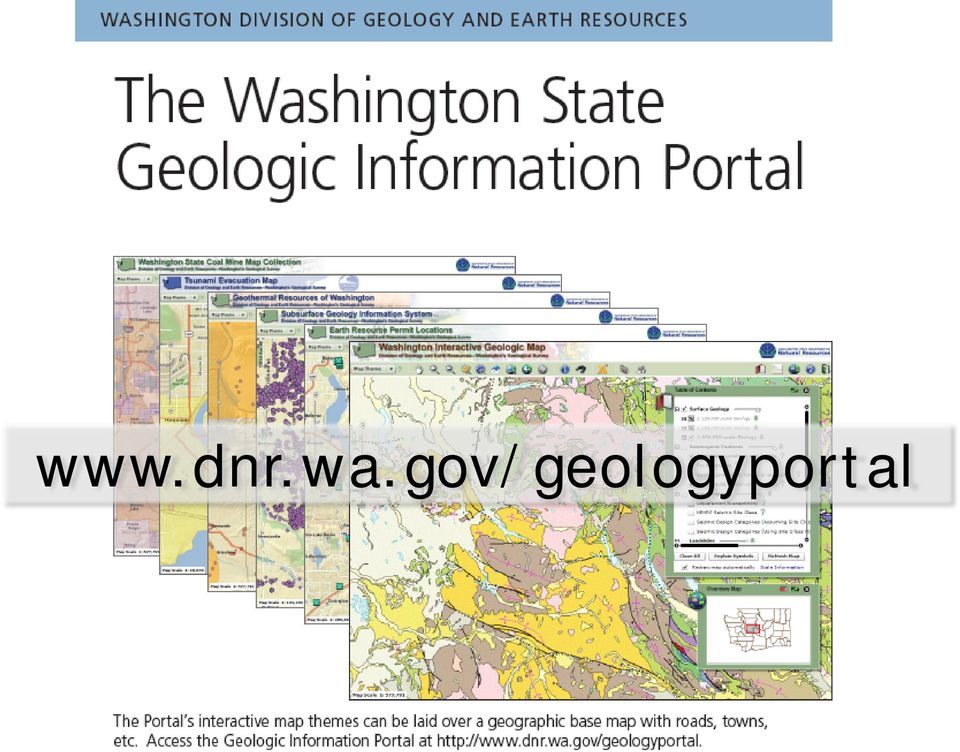
16 dnr.wa.gov/geologyportal

17

18 PRE-SR530 Landslide Hazards Program was ~½ FTE Despite Washington having a history of damaging landslides Public usually didn t pay much attention to landslides Landslides impacted timberlands, national parks, rural areas, railroads, big houses on Puget Sound bluffs

19

20 POST-SR530 Created a state/county geologist workgroup to discuss future landslide mapping efforts Develop a common landslide inventory and susceptibility protocol

21 SR530 LANDSLIDE COMMISSION Recommendation 2: Support a statewide landslide hazard and risk mapping program
22 FUNDING REQUEST TO THE LEGISLATURE $6.6 million for 14 new full-time positions Five position in landslide hazards group Support staff, more lidar, and more staff geologists
23 CONCERNS? Not understood that there are >>100,000 landslides across this state 58,000 landslides a good start? What will be the response to landslide mapping in communities? Impact property values? Home sales? Property owners don t want to know; property buyers do
24 THE NEXT SIX MONTHS Rewrite our existing landslide protocol Emphasize human life, critical infrastructure, and lidar Collaborate with counties, states, and USGS Complete redesign of database schema Based on the assumption the decision package will pass and is funded
25 BEYOND SIX MONTHS Develop a protocol for landslide hazard, risk, and runout mapping Significantly increase public outreach and education Begin the hiring process for five hazards geologists??? or ½ time Landslide Hazards Geologist
26
Keynote 2: What is Landslide Hazard? Inventory Maps, Uncertainty, and an Approach to Meeting Insurance Industry Needs
 Keynote 2: What is Landslide Hazard? Inventory Maps, Uncertainty, and an Approach to Meeting Insurance Industry Needs Jeffrey R Keaton Richard J Roth, Jr Amec Foster Wheeler Los Angeles, USA Consulting
Oregon Pre-Disaster Mitigation Program Plan Update Training Manual
 FEMA Oregon Pre-Disaster Mitigation Program Plan Update Training Manual Prepared by: Oregon Partnership for Disaster Resilience OPDR FEMA OPDR FEMA OPDR 2010, University of Oregon s Community Service Center
MINNESOTA DEPARTMENT OF NATURAL RESOURCES. Division of Forestry
 MINNESOTA DEPARTMENT OF NATURAL RESOURCES Division of Forestry Other major programs: Private Forest Management Urban and Community Forestry Insect and Disease Management Urban and Community Forestry
3. The submittal shall include a proposed scope of work to confirm the provided project description;
 QIN Shoreline Master Program Project Summary The Shoreline Master Program (SMP) development process for the Quinault Indian Nation (QIN) includes the completion of inventory and analysis report with corresponding
Graduate School of Disaster Prevention Kangwon National University. http://college.kangwon.ac.kr/prevention/main.jsp
 Graduate School of Disaster Prevention Kangwon National University 1joongang-Ro Samcheok-city, Gangwon-Do, Republic of Korea http://college.kangwon.ac.kr/prevention/main.jsp Outline Natural disasters such
Appendix B. Introduction to Landslide Evaluation Tools Mapping, Remote Sensing, and Monitoring of Landslides
 Appendix B. Introduction to Landslide Evaluation Tools Mapping, Remote Sensing, and Monitoring of Landslides 66 The Landslide Handbook A Guide to Understanding Landslides Part 1. Mapping Maps are a useful
Landslides & Mudflows
 1 2 - What is a Landslide? - Geologic hazard Common to almost all 50 states Annual global Billions in losses Thousands of deaths and injuries 3 1 - What is a Landslide? - Gravity is driving force Some
Presentation Program Outline
 Presentation Program Outline IRWM Program Background San Diego IRWM Planning 2013 IRWM Update Integrated Flood Management Flood Management Planning Study IRWM Program Background What is IRWM? Collaborative
DPAC- DLGSEM and MRT. Landslide planning matrix
 DPAC- DLGSEM and MRT Landslide planning matrix Thank you to MRT, council planners, and the TPC for their support in this work DPAC- DLGSEM and MRT Process thus far Regional workshops (April May) Follow
Utah State General Records Retention Schedule SCHEDULE 1 GEOSPATIAL DATA SETS
 Utah State General Records Retention Schedule SCHEDULE 1 BIOTA RECORDS (Item 1-26) These are geospatial records that depict wildlife use areas in the state of Utah as determined by wildlife biologists
CLINTON COUNTY HAZARD MITIGATION PLAN
 EXECUTIVE SUMMARY. 1-4 1.0 INTRODUCTION.. 5-11 1.1 Hazard Mitigation Planning and the Disaster Mitigation Act of 2000 5-6 1.2 Multi-Jurisdictional Plan Adoption 7 1.3 Multi-Jurisdictional Planning Participation..
DRAFT HAZARD MITIGATION PLAN TOOLKIT: MASTER TABLE
 DRAFT HAZARD MITIGATION PAN TOOKIT: MASTER TABE Steps Requirements Addressed Click to Overview slide presentation on "Getting Started Developing a Hazard Mitigation Plan" Plan Development Overview Introductory
HOMEOWNER S GUIDE. to LANDSLIDES. and MITIGATION RECOGNITION, PREVENTION, CONTROL, Compiled by Dr. Scott F. Burns Tessa M. Harden Carin J.
 HOMEOWNER S GUIDE to LANDSLIDES RECOGNITION, PREVENTION, CONTROL, and MITIGATION Compiled by Dr. Scott F. Burns Tessa M. Harden Carin J. Andrew Federal Emergency Management Agency Region 10 If you are
INSURANCE FOR LANDSLIDE DAMAGE: THINKING OUTSIDE THE SHEAR BOX
 INSURANCE FOR LANDSLIDE DAMAGE: THINKING OUTSIDE THE SHEAR BOX Richard J. Roth, Jr. 1 and Jeffrey R. Keaton 2 1 Consulting Actuary, Huntington Beach, California, USA (e-mail: [email protected]) 2 MACTEC
Development of National Geotechnical Management System Standards for Transportation Applications
 Development of National Geotechnical Management System Standards for Transportation Applications Thomas E. Lefchik P.E. 1 and Kirk Beach 2 1 Federal Highway Administration, 200 N. High Street, Room 328,
CHAPTER 2: APPROACH AND METHODS APPROACH
 CHAPTER 2: APPROACH AND METHODS APPROACH Given Hawaii s biological uniqueness on a global scale, the Comprehensive Wildlife Conservation Strategy (CWCS) recognizes the importance of protecting all native
Earth Data Science in The Era of Big Data and Compute
 Earth Data Science in The Era of Big Data and Compute E. Lynn Usery U.S. Geological Survey [email protected] http://cegis.usgs.gov U.S. Department of the Interior U.S. Geological Survey Board on Earth Sciences
Landslides: The Poor Stepchild of GeoHazards; What We and Other Countries Can Do to Solve It! Scott Burns Portland State University Dept.
 Landslides: The Poor Stepchild of GeoHazards; What We and Other Countries Can Do to Solve It! Scott Burns Portland State University Dept. of Geology Afghanistan: 2014: 2700 dead West Salt Creek Landslide,
Development of an Impervious-Surface Database for the Little Blackwater River Watershed, Dorchester County, Maryland
 Development of an Impervious-Surface Database for the Little Blackwater River Watershed, Dorchester County, Maryland By Lesley E. Milheim, John W. Jones, and Roger A. Barlow Open-File Report 2007 1308
Project Overview. Kirk Beach Ohio Department of Transportation. ODOT Geotechnical Data Management System. Office of Geotechnical Engineering
 Project Overview ODOT Geotechnical Data Management System Kirk Beach Ohio Department of Transportation Office of Geotechnical Engineering Geology and Exploration Section Project Goals Development of a
CIESIN Columbia University
 Conference on Climate Change and Official Statistics Oslo, Norway, 14-16 April 2008 The Role of Spatial Data Infrastructure in Integrating Climate Change Information with a Focus on Monitoring Observed
National Network of Reference Watersheds
 National Network of Reference Watersheds National Water Quality Monitoring Council (NWQMC) Advisory Committee for Water Information (ACWI) Present proposal to NWQMC - approved May 2011 Present proposal
CDI SSF Category 1: Management, Policy and Standards
 CDI SSF Category 1: Management, Policy and Standards Developing a Data Management Plan for Implementation: Best Practices for the Collection, Management, Storing, and Sharing of Geospatial and Non-geospatial
GIS Data Discovery Workshop
 Florida Division of Emergency Management 1 GIS Data Discovery Workshop Richard Butgereit GIS Administrator 850-413-9907 [email protected] floridadisaster.org/gis Critical Facilities Inventory
HAZUS 2014. 7 th Annual Conference
 HAZUS 2014 7 th Annual Conference HAZUS Comparison of Storm Surge Levels from Different Hurricanes to the Newest SLOSH Models for Berkeley, Charleston, & Dorchester Counties Along the SC Coastline. Charlie
Minnesota State Plan Review Level 2 Hazus-MH 2.1 County Model for Flooding Dakota County Evaluation
 Overview Minnesota State Plan Review Level 2 Hazus-MH 2.1 County Model for Flooding Dakota County Evaluation Minnesota Homeland Security and Emergency Management (HSEM) is responsible for supporting activities
Island County, Washington REQUEST FOR PROPOSALS (RFP) GIS Data Inventory Update for Shoreline Compliance
 GIS Data Inventory Update for Shoreline Compliance") Island County, Washington REQUEST FOR PROPOSALS (RFP) GIS Data Inventory Update for Shoreline Compliance Send Proposal Packages to: Tess Cooper, Critical Area Planner Island County Planning and Community
Island County, Washington REQUEST FOR PROPOSALS (RFP) GIS Data Inventory Update for Shoreline Compliance Send Proposal Packages to: Tess Cooper, Critical Area Planner Island County Planning and Community

METHODOLOGY FOR LANDSLIDE SUSCEPTIBILITY AND HAZARD MAPPING USING GIS AND SDI
 The 8th International Conference on Geo-information for Disaster Management Intelligent Systems for Crisis Management METHODOLOGY FOR LANDSLIDE SUSCEPTIBILITY AND HAZARD MAPPING USING GIS AND SDI T. Fernández
February 28 Earthquake: We got off easy
 February 28 Earthquake: We got off easy State Geologist John Beaulieu Lucky may not be the first word that comes to mind after an earthquake that injured more than 200 and caused more than $1 billion damage,
Rafi Ahmad & Parris Lyew-Ayee
 Challenges with Spatial Information in the Caribbean Rafi Ahmad & Parris Lyew-Ayee Mona GeoInformatics Institute The University of the West Indies at Mona, Jamaica Challenges associated with: Data availability
Why does Kittitas County want to form a Flood Control Zone District?
 KITTITAS COUNTY DEPARTMENT OF PUBLIC WORKS Kirk Holmes, Director What is a Flood Control Zone District (FCZD)? A Kittitas County Flood Control Zone District (FCZD) would be a special-purpose government
An Initial Assessment of the Impacts of Sea Level Rise to the California Coast
 An Initial Assessment of the Impacts of Sea Level Rise to the California Coast Photo by D. Revell 2/23/08 California Coastal Records Project Dr. David Revell and Matt Heberger, P.E. Dr. Peter Gleick, Bob
Seattle: Using vegetation to limit the hazard of landslides
 Seattle: Using vegetation to limit the hazard of landslides Climate change impacts addressed Spatial scale Response type Themes driving the initiative Factors of success Ground instability Town or city
SAN JUAN COUNTY. MARINE RESOURCES Committee (MRC) Meeting Minutes. Wednesday, April 1, 2015, 8:30 10:30am. Legislative Hearing Room
 Meeting Minutes. Wednesday, April 1, 2015, 8:30 10:30am. Legislative Hearing Room") SAN JUAN COUNTY MARINE RESOURCES Committee (MRC) Meeting Minutes Wednesday, April 1, 2015, 8:30 10:30am Legislative Hearing Room 55 Second Street, Friday Harbor, WA Members Present: Laura Arnold, Kathleen
SAN JUAN COUNTY MARINE RESOURCES Committee (MRC) Meeting Minutes Wednesday, April 1, 2015, 8:30 10:30am Legislative Hearing Room 55 Second Street, Friday Harbor, WA Members Present: Laura Arnold, Kathleen
The Future of Geospatial Big Data Giovanni Marchisio, Ph.D., Director Product Development
 The Future of Geospatial Big Data Giovanni Marchisio, Ph.D., Director Product Development Nuclear Power Plant, Doel, Belgium December 10, 2011 WorldView-2 Why Geospatial Big Data? We Are the Innovators
MD imap 2.0 THE NEXT GENERATION OF MARYLAND S ENTERPRISE GIS. Esri MUG Conference Baltimore, MD December 3, 2014 http://imap.maryland.
 THE NEXT GENERATION OF MARYLAND S ENTERPRISE GIS MD imap 2.0 Matt Sokol, GISP Senior GIS Analyst Maryland Department of Information Technology Geographic Information Office Julia Fischer, GISP Senior GIS
NAGT Who are we? http://nagt.org
 NAGT Who are we? http://nagt.org by Janis D. Treworgy President of NAGT 2010 2011 Professor of Geology Principia College, Elsah, IL [email protected] As professional geoscientists, you may daily
Flood Risk Management
 Flood Risk Management Value of Flood Risk Management Every year floods sweep through communities across the United States taking lives, destroying property, shutting down businesses, harming the environment
Flood Risk Management
 Flood Risk Management Value of Flood Risk Management Value to Individuals and Communities Every year floods sweep through communities across the United States taking lives, destroying property, shutting
NPLOTH7 GIS Database Development Mission (2619), Bryson (2601), Franklin (2603), Dillsboro (2602) Final Report
, Bryson (2601), Franklin (2603), Dillsboro (2602) Final Report") NPLOTH7 GIS Database Development Mission (2619), Bryson (2601), Franklin (2603), Dillsboro (2602) Final Report Introduction Duke Power Nantahala Area (Duke) is in the process of relicensing the Mission,
NPLOTH7 GIS Database Development Mission (2619), Bryson (2601), Franklin (2603), Dillsboro (2602) Final Report Introduction Duke Power Nantahala Area (Duke) is in the process of relicensing the Mission,

PORT OF SEATTLE MEMORANDUM. COMMISSION AGENDA Item No. 4d ACTION ITEM Date of Meeting September 8, 2015
 PORT OF SEATTLE MEMORANDUM COMMISSION AGENDA Item No. 4d ACTION ITEM Date of Meeting September 8, 2015 DATE: TO: FROM: Michael Ehl, Director Aviation Operations SUBJECT: Pest Control Services to Support
Conducting a Land Use Inventory
 Chapter 3 Conducting a Land Use Inventory Included in this chapter: Determining Current Land Use Conditions Preparing a Base Map Deciding on Land Use Categories Collecting Current Land Use Data Preparing
Metadata for Big River Watershed Geologic and Geomorphic Data
 Metadata for Big River Watershed Geologic and Geomorphic Data Metadata are descriptions and information regarding compiled data. This appendix contains the metadata that describes the compiled data used
HAZARD VULNERABILITY & RISK ASSESSMENT
 Hazard Vulnerability Analysis Purpose and Scope A Hazard Vulnerability Analysis (HVA) evaluates risk associated with a specific hazard. During this analysis, the hazard is evaluated for its probability
Town of Warwick, Village of Florida, Village of Greenwood Lake and Village of Warwick MULTI JURISIDICTIONAL, MULTI HAZARD MITIGATION PLAN DRAFT
 Town of Warwick, Village of Florida, Village of Greenwood Lake and Village of Warwick MULTI JURISIDICTIONAL, MULTI HAZARD MITIGATION PLAN DRAFT Appendix B Historical Hazard Documentation Rev #0 May 2013
LANDSLIDE LOSS ESTIMATION PILOT PROJECT IN OREGON
 STATE OF OREGON DEPARTMENT OF GEOLOGY AND MINERAL INDUSTRIES Suite 965, 800 NE Oregon St., #28 Portland, Oregon 97232 OPEN-FILE REPORT O-02-05 LANDSLIDE LOSS ESTIMATION PILOT PROJECT IN OREGON By Yumei
Emerging Trends in SDI.
 Emerging Trends in SDI. Jeanne Foust ESRI gsdi 1 Spatial Data Infrastructure TRENDS GIS use continues to rapidly grow. Recognition Of GIS As Critical Infrastructure growing. Alignment of SDI and National
State of Oregon Department of Consumer and Business Services Building Codes Division. Oregon epermitting
 State of Oregon Department of Consumer and Business Services Building Codes Division Oregon epermitting 2011 Category: Cross-Boundary Collaboration and Partnerships Project Managers Lori Graham, Building
Critical Assets and Extreme Weather Process & Lessons
 Critical Assets and Extreme Weather Process & Lessons Steven Olmsted Intermodal Transportation Division Arizona Department of Transportation 2014 Transportation Asset Management Conference April 28-30,
ALTERNATIVE SOURCES OF FUNDING FOR
 November 2015 ALTERNATIVE SOURCES OF FUNDING FOR Flood-Related General Water Management Water Supply Projects The following inventory contains information about a variety of funding programs offered by
Toma Danila Dragos. National Institute for Earth Physics Romania
 Toma Danila Dragos National Institute for Earth Physics Romania Before: evaluate the hazard and risk, be prepared for worst case scenario Natural or antropic disaster After: quickly evaluate the situation
Coastal Erosion. May 2012. Overview. Why does it occur? What are the consequences? What is the cost to the UK economy?
 Coastal Erosion UK Geohazard Note Overview Coastal erosion can be defined as the removal of material from the coast by wave action, tidal currents and/or the activities of man, typically causing a landward
DRAFT. Shoreline adaptation alternatives development to determine flood reduction potential and project costs
 Scope of Services Phase 1A: Flood Damage Assessment Economic Analysis of the Delaware Bay Shoreline Adaptation Alternatives Task Order No. 1A Structures/Affected Property Inventory January 13, 2011 Johnson,
The following was presented at DMT 14 (June 1-4, 2014, Newark, DE).
.") DMT 2014 The following was presented at DMT 14 (June 1-4, 2014, Newark, DE). The contents are provisional and will be superseded by a paper in the DMT 14 Proceedings. See also presentations and Proceedings
DMT 2014 The following was presented at DMT 14 (June 1-4, 2014, Newark, DE). The contents are provisional and will be superseded by a paper in the DMT 14 Proceedings. See also presentations and Proceedings
$200 Billion. Ecosystem Services: The Gridlock Breaker. Four Types of Capital. Built Capital Social Capital Human Capital Natural Capital
 Ecosystem Services: The Gridlock Breaker Four Types of Capital A session of the 2012 Washington State APA Conference Olympia, Washington 0ctober 12, 2012 Doug Osterman, Steve Hughes Tracy Stanton, Dave
Appendix B REFERENCES
 Appendix B REFERENCES 2007 Field Reconnaissance Report of Bank Erosion Sites and Site Priority Ranking. Sacramento River Flood Control Levees, Tributaries and Distributaries American Red Cross. www.redcross.org
DISASTER RISK DETECTION AND MANAGEMENT COURSES SETUP SCENARIO AT MAKERERE UNIVERSITY. Makerere University
 DISASTER RISK DETECTION AND MANAGEMENT COURSES SETUP SCENARIO AT MAKERERE UNIVERSITY CASE OF THE DEPARTMENT OF GEOGRAPHY Derek Muhwezi 2 MISSION OF THE DEPARTMENT To provide and promote quality education,
TEXAS GROUNDWATER PROTECTION COMMITTEE Data Management Subcommittee Subcommittee Charge
 TEXAS GROUNDWATER PROTECTION COMMITTEE Data Management Subcommittee Subcommittee Charge Date Approved April 17, 2013 Sponsor Texas Groundwater Protection Committee (TGPC) Co-Chairs Texas Commission on
Natural Hazards 1.1. Natural Hazards. Objective: Natural Hazards in Western Australia Are we at risk? Page 1. Natural Hazards Years 5-7
 Natural Hazards 1.1 Engage Natural Hazards To introduce students to the natural hazards which occur in Western Australia and their risk. Western Australia experiences a range of natural hazards each year,
DRF 1 COMMUNITY ORGANIZATIONS ACTIVE IN DISASTER (COAD)
") DRF 1 COMMUNITY ORGANIZATIONS ACTIVE IN DISASTER (COAD) CONTENTS PAGE I. PURPOSE 1 II. SCOPE 1 III. SITUATION AND ASSUMPTIONS 1 A. Situation 1 B. Assumptions 2 IV. CONCEPT OF OPERATIONS 2 A. General 2
DRF 1 COMMUNITY ORGANIZATIONS ACTIVE IN DISASTER (COAD) CONTENTS PAGE I. PURPOSE 1 II. SCOPE 1 III. SITUATION AND ASSUMPTIONS 1 A. Situation 1 B. Assumptions 2 IV. CONCEPT OF OPERATIONS 2 A. General 2
Appendix J Online Questionnaire
 Appendix J Online Questionnaire In accordance with the Paperwork Reduction Act, this questionnaire was approved by the Office of Management and Budget (OMB). The OMB control number and expiration date
GENERAL OBLIGATION BONDS
 DESCRIPTIONS GENERAL OBLIGATION BONDS Appendix C, page 2 GENERAL OBLIGATION BONDS State Transportation Bonds --- 1968 An amount of $640,000,000 was authorized to improve the public transportation system.
CAPRA Software Gabriel Bernal ITEC SAS - ERN-AL Consortium
 CAPRA Software Gabriel Bernal ITEC SAS - ERN-AL Consortium ERN CAPRA software CAPRA platform Data management FileCAT Hazard module Exposure module Vulnerability module Risk module CRISIS 2007 ERN-NH rainfall
TERRITORIAL PLANNING FOR THE MANAGEMENT OF RISK IN EUROPE
 , Territorial págs. Planning 383-388 for the Management of Risk in Europe TERRITORIAL PLANNING FOR THE MANAGEMENT OF RISK IN EUROPE Mark Fleischhauer, Stefan Greiving & Sylvia Wanczura Universität Dortmund
BEFORE THE HEARING EXAMINER FOR THURSTON COUNTY
 BEFORE THE HEARING EXAMINER FOR THURSTON COUNTY In the Matter of the Application of ) NO. SSDP 000748 ) Kevin Robinson ) FINDINGS, CONCLUSIONS ) AND DECISION For a Shoreline Substantial Development ) Permit
21st International Conference of The Coastal Society
 21st International Conference of The Coastal Society MARINE STEWARDSHIP AREA OFFERS A MODEL FOR INTEGRATING SCIENCE, MANAGEMENT, STEWARDSHIP AND ECOSYSTEM THINKING IN THE CONSERVATION OF COASTAL RESOURCES
2010 Update to the State of Montana Multi-Hazard Mitigation Plan and Statewide Hazard Assessment 4.0 RISK ASSESSMENT
 4.0 RISK ASSESSMENT The Risk Assessment portion of this document provides a detailed description of the hazards in Montana, an assessment of the State s vulnerability to those hazards, and a basis for
What is required of a compliant Risk Assessment?
 What is required of a compliant Risk Assessment? ACR 2 Solutions President Jack Kolk discusses the nine elements that the Office of Civil Rights requires Covered Entities perform when conducting a HIPAA