Rafi Ahmad & Parris Lyew-Ayee
|
|
|
- Melvyn Taylor
- 10 years ago
- Views:
Transcription
1 Challenges with Spatial Information in the Caribbean Rafi Ahmad & Parris Lyew-Ayee Mona GeoInformatics Institute The University of the West Indies at Mona, Jamaica

2 Challenges associated with: Data availability Includes digital and non-digital data Skills sets to process primary data and derive secondary data models GIS professionals without hazard training Hazard professionals without GIS training Ability to translate core hazard concepts into workable models in a GIS (steep slopes alone do not mean landslides, etc) Demand from end users for true innovation and new approaches to old problems Narrowly-defined technological solutions, rather than broader approaches which include technological approaches as part of solution

3 Challenges Similar throughout region Data issues range from: Availability of data Diversity of data Scale very important when adapting First World methodologies and systems to the small islands of the Caribbean Significant analytical deficiencies

4 MGI Experiences Develop entirely new approaches and processes Utilizes GIS, but not exclusively Input not necessarily from digitizing old maps or from GPS field survey for data generation Utilize old reports Interpret media reports Utilize social networks and data mining mechanisms Output not necessarily a map or a traditional GIS system May include model parameters for insurance underwriting and assessment Interactive simulations or web maps Publications (Natural Hazards Atlas of Jamaica in press) Create new markets for hazard mapping and GIS Insurance sector Real estate sector ***Need to understand market needs and budgets, not necessarily to forcefeed it with what scientists believe the industry should do***

5 MGI Experiences Results already being practically applied in Jamaica Insurance sector actively using MGI s system in underwriting, claims and reinsurance Real estate and infrastructure developers using GIS for site selection and geotechnical engineering Policy makers actively using MGI system in development of National Spatial Plan for Jamaica, and in the assisting with the development approvals process Investors using MGI system to plan, meshing hazards and environmental data with socioeconomic considerations

6 MGI DATABASE & GEM This presentation will show available data that may be imported into the GEM platform

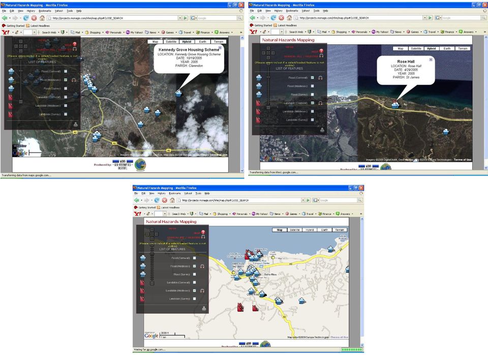
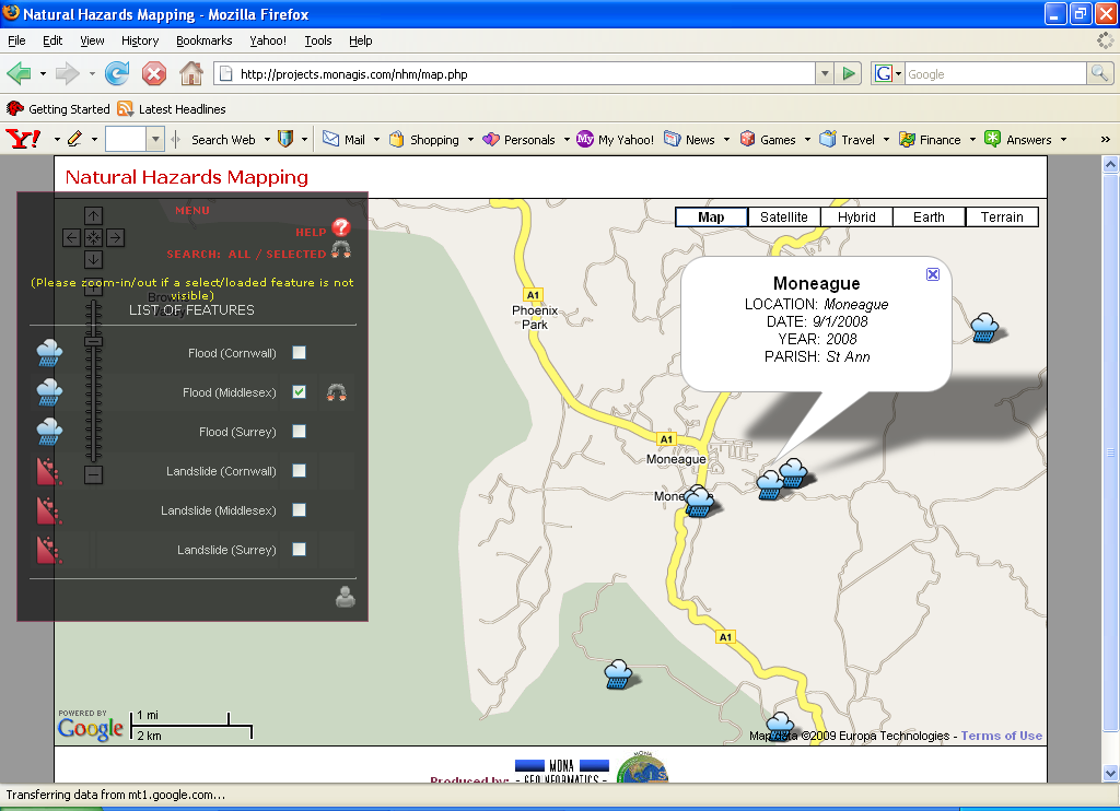
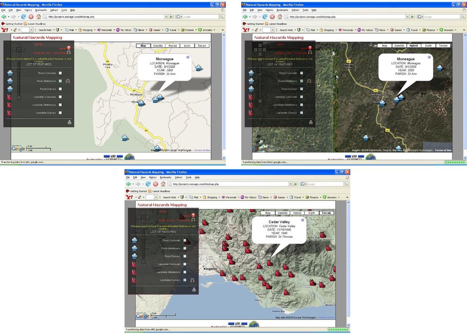
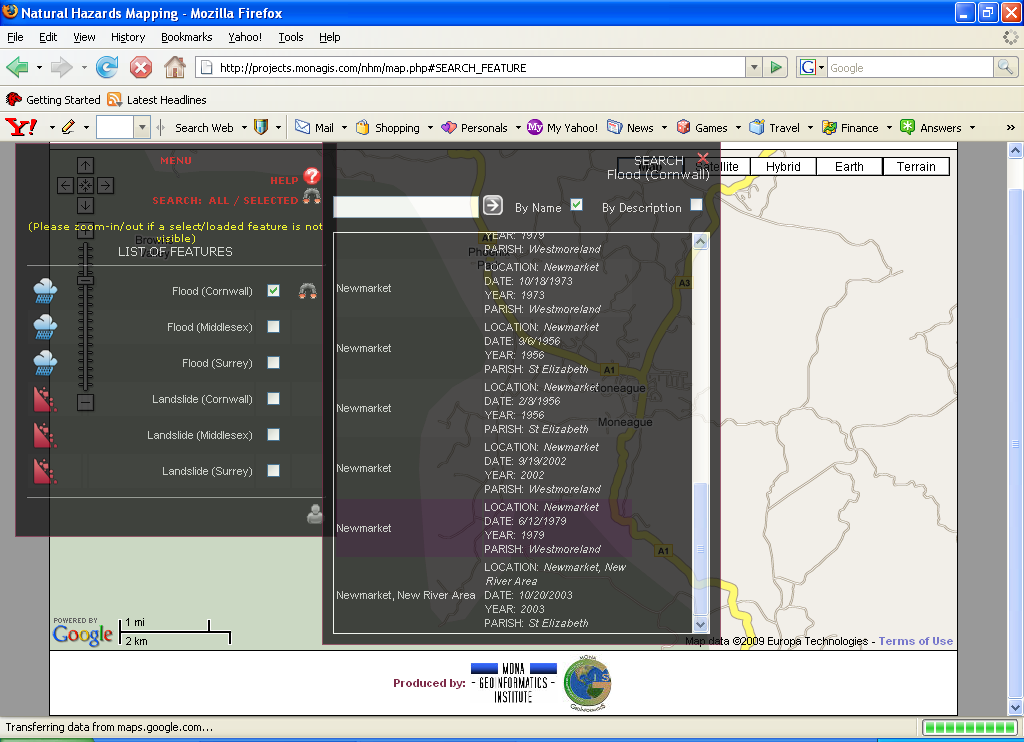
7 Interactive Hazards Archive Map

8 About the System Aim: create a mechanism/system useful to all possible users & stakeholders of hazard event information-multiple hazards scenario to be able to identify events that affected their houses/communities EXAMPLE All references to FLOODS and LANDSLIDES in the entire Jamaica Gleaner Archives mapped Excluding references to general flood/landslide editorials and/or general policy discussions Also excluding non-hazard flood/landslide references ( West Indies lost by a landslide to the Pakistan cricket team ; Cable and Wireless was flooded with calls ) Including field and literature verification Records date back to the 1830 s
 Including field and literature verification Records date back to the 1830")
9 Points to Note Not as comprehensive as an official hazard event survey, but predates such official institutions by, in some cases, a century Reports on major and minor floods and landslides included, not just the spectacular events that make the news (1907 earthquake, etc) Communities where event occurred mapped; no detail on precise location from report Only places where the impact affected people and/or infrastructure were reported, and hence mapped; other areas that were inaccessible and/or had no people may not have attracted attention to be reported on 150 years ago Products are Hazard maps: Inventory group All ground types are represented, points to controls by specific ground types


10 Floods typically occur along inland alluvial plains. Flooding is also exacerbated by urbanization, with increasing areas of paved surfaces and deforestation. Flooding along major river valleys is also prevalent.


11 Landslides preferentially occur along fault scarps throughout the island. River valley slopes are decorated with old and young landslides which supply abundant sediments to rivers. Landslide debris is exploited for aggregate, examples: Yallahs River, Morant River, Wagwater River.


12 Technical Points System based on Google API Provides detailed satellite imagery ala Google Earth, but allows user content to be added and manipulated Provides immediate accessibility to many different users via web interface; no need for specialized software and/or training Full GIS-style accessibility in terms of query, zoom-pan functions, and turning layers on and off

13


14
15

16

17 Disaster Simulator integrates hazard principles of location, infrastructure and event type, and generates over 2000 different combinations of impact 4 hazards: earthquake (mild, serious, catastrophic), tropical cyclones (from tropical storms to Category 5 hurricanes), floods and landslides, and combinations of secondary impacts etc Different wall and roof and foundation types Different landscape environments


18


19

20 Haiti-in-Jamaica Earthquake Simulation Developed for NEM Insurance as a tool to assess its reinsurance cover Quantitatively addresses concerns in industry, government and general public (through the media) about a What-If scenario Integrates geological and geophysical information (in the actual model simulation) with analysis of impact on society, infrastructure and economy Provides immediately useful and usable information
 with analysis of impact on society, infrastructure and economy Provides immediately useful and")
21
22
23 The Results Entire island would feel the earthquake Over 75% would feel shaking enough to begin to cause structural damage in some buildings Including an extent containing over 2.2M people and over 480,000 buildings Eastern Jamaica would feel the worst effects 87% of Portland and 83% of St Thomas by area would experience MMI VIII
24 Specific Areas of Concern Portmore Large-scale housing development Developed on reclaimed land Untested by major ground-shaking event Many unauthorized housing extensions and expansions Norman Manley International Airport Runway developed on reclaimed land Palisadoes has proven history of liquefaction from tip to tip Airports are critical hubs for relief supplies and coordination Downtown Kingston Waterfront Reclaimed land with multi-storey tower blocks and intensive development Critical facilities include Jamaica s Central Bank Newport West and Petrojam Reclaimed land Critical facilities for utilities (including power supply at Hunt s Bay) and supplies *** ALL SUSCEPTIBLE TO LIQUEFACTION ***


25 Adapted from CDMP Report, 1999
26 NEM Portfolio Analysis Far more detailed breakdown of building type, by roof and wall, along with sum insured valuations Different construction types would experience different types of damage, depending on their locations (ground shaking) and construction types Similar buildings in different areas experiencing different peak ground acceleration would not experience similar damage Different building types in areas experiencing similar peak ground acceleration would experience different damage
27
28 Weighing the Model
29 NEM Portfolio Analysis Results can be used for reinsurance negotiations and pricing Underwriting analyses and premium calculations Dynamic model able to incorporate changes in portfolio characteristics
30 Conclusions Challenges being overcome with scientific and technological innovation Different approaches to old problems Applies solid theory and approaches with technology Use technology for different purposes: Information exchange and generation of awareness Decision making Analysis and modeling» Same raw datasets can be used for different objectives» For example: GEM Platform THANK YOU
Pacific Catastrophe Risk Assessment and Financing Initiative. Better Information for Smarter Investments
 Pacific Catastrophe Risk Assessment and Financing Initiative Better Information for Smarter Investments Main Outputs Pacific disaster risk assessment Probabilistic assessment of major perils Pacific Risk
The Use of Geographic Information Systems in Risk Assessment
 The Use of Geographic Information Systems in Risk Assessment With Specific Focus on the RiVAMP Methodology Presented by Nadine Brown August 27, 2012 Climate Studies Group Mona Climate Change Workshop Presentation
The Caribbean Disaster Mitigation Project: Supporting Sustainable Responses to Natural Hazards
 The Caribbean Disaster Mitigation Project: Supporting Sustainable Responses to Natural Hazards Steven Stichter Caribbean Disaster Mitigation Project (CDMP) Unit of Sustainable Development and Environment
How can we defend ourselves from the hazard of Nature in the modern society?
 How can we defend ourselves from the hazard of Nature in the modern society?, University of Bologna President of the EGU Division of Natural Hazards Email: [email protected] [email protected] GIFT 2013 Natural
Caribbean Catastrophe Risk Insurance Facility (CCRIF)
") CCRIF/Swiss Re Excess Rainfall Product A Guide to Understanding the CCRIF/Swiss Re Excess Rainfall Product Published by: Caribbean Catastrophe Risk Insurance Facility (CCRIF) Contact: Caribbean Risk Managers
CCRIF/Swiss Re Excess Rainfall Product A Guide to Understanding the CCRIF/Swiss Re Excess Rainfall Product Published by: Caribbean Catastrophe Risk Insurance Facility (CCRIF) Contact: Caribbean Risk Managers
MANAGING NATURAL HAZARDS IN JAMAICA
 Page 1 of 11 Disaster Do Happen.. BACK - HOME INFORMATION MENU MANAGING NATURAL HAZARDS IN JAMAICA By Ronald Jackson Acting Deputy Director General Office of Disaster Preparedness and Emergency Management
Building a Spatial Database for Earthquake Risk Assessment and Management in the Caribbean
 Building a Spatial Database for Earthquake Risk Assessment and Management in the Caribbean Jacob Opadeyi and Rehanna Jadoo Department of Geomatics Engineering and Land Management, The University of the
Natural Disasters & Assessing Hazards and Risk. Natural Hazards and Natural Disasters
 Page 1 of 9 EENS 3050 Tulane University Natural Disasters Prof. Stephen A. Nelson Natural Disasters & Assessing Hazards and Risk This page last updated on 19-Aug-2014 Natural Hazards and Natural Disasters
The correct answers are given below. Some talking points have been added for the teachers use.
 Natural Resources Canada 2011: Lesson Plan Grades 11 and 12 Landslide activity 5b: Landslides in Canada quiz Description: This is an independent study activity for grades 11 and 12. Students will read
Appendix J Online Questionnaire
 Appendix J Online Questionnaire In accordance with the Paperwork Reduction Act, this questionnaire was approved by the Office of Management and Budget (OMB). The OMB control number and expiration date
PACIFIC CATASTROPHE RISK ASSESSMENT AND FINANCING INITIATIVE
 PACIFIC CATASTROPHE RISK ASSESSMENT AND FINANCING INITIATIVE NIUE SEPTEMBER 11 COUNTRY RISK PROFILE: NIUE Niue is expected to incur, on average,.9 million USD per year in losses due to earthquakes and
Using Insurance Catastrophe Models to Investigate the Economics of Climate Change Impacts and Adaptation
 Using Insurance Catastrophe Models to Investigate the Economics of Climate Change Impacts and Adaptation Dr Nicola Patmore Senior Research Analyst Risk Management Solutions (RMS) Bringing Science to the
4.6 GEOLOGIC AND SEISMIC HAZARDS
 4.6 GEOLOGIC AND SEISMIC HAZARDS This Section describes the current conditions relating to the geologic and seismic characteristics of the City of Cypress. This Section concludes with an analysis of geologic
Building Caribbean GeoNode Platform in Support of Climate Risk Management Jacob Opadeyi, PhD
 Building Caribbean GeoNode Platform in Support of Climate Risk Management Jacob Opadeyi, PhD Our Highly Vulnerable Region Housing developments on drainage channels and steep slopes Unapproved development
Flood Zone Investigation by using Satellite and Aerial Imagery
 Flood Zone Investigation by using Satellite and Aerial Imagery Younes Daneshbod Islamic Azad University-Arsanjan branch Daneshgah Boulevard, Islamid Azad University, Arsnjan, Iran Email: [email protected]
Keynote 2: What is Landslide Hazard? Inventory Maps, Uncertainty, and an Approach to Meeting Insurance Industry Needs
 Keynote 2: What is Landslide Hazard? Inventory Maps, Uncertainty, and an Approach to Meeting Insurance Industry Needs Jeffrey R Keaton Richard J Roth, Jr Amec Foster Wheeler Los Angeles, USA Consulting
NATURAL HAZARD AND VULNERABILITY ASSESSMENT FOR PORTMORE, ST. CATHERINE. Presenters: Norman Harris & Rupert Green Mines and Geology Division
 NATURAL HAZARD AND VULNERABILITY ASSESSMENT FOR PORTMORE, ST. CATHERINE Presenters: Norman Harris & Rupert Green Mines and Geology Division BACKGROUND UNDP Funded Project Project began in July 2006; 14
GEOGRAPHIC INFORMATION SYSTEMS
 GEOGRAPHIC INFORMATION SYSTEMS WHAT IS A GEOGRAPHIC INFORMATION SYSTEM? A geographic information system (GIS) is a computer-based tool for mapping and analyzing spatial data. GIS technology integrates
Utilizing satellite-based information for disaster risk assessment- why and how?
 Utilizing satellite-based information for disaster risk assessment- why and how? Peeranan Towashiraporn ADPC Session 1, UN International Conference on Space-based Technologies for Disaster Management September
Tool 2.3.1: General information on the causes of rainfall-induced landslides
 Impacts of Climate Change on Urban Infrastructure & the Built Environment A Toolbox Tool 2.3.1: General information on the causes of rainfall-induced landslides Author G. Dellow Affiliation GNS Science,
Assessing the Costs of Disasters on Jamaica s Infrastructure: Evidence from the Damage and Loss Assessment by the Planning Institute of Jamaica
 Assessing the Costs of Disasters on Jamaica s Infrastructure: Evidence from the Damage and Loss Assessment by the Planning Institute of Jamaica Jamaica s Vulnerability to Natural Hazards Methodology ECLAC
Climate Change in Mexico implications for the insurance and reinsurance market
 Climate Change in Mexico implications for the insurance and reinsurance market Eberhard Faust Geo Risks Research Munich Reinsurance Company 1980 April 2008: Billion & Ten Billion Dollar Losses The costliest
Risk and Vulnerability Assessment Methodology Development Project (RiVAMP) Presented by: Planning Institute of Jamaica August 27, 2012
 Presented by: Planning Institute of Jamaica August 27, 2012") Risk and Vulnerability Assessment Methodology Development Project (RiVAMP) Presented by: Planning Institute of Jamaica August 27, 2012 Content of Presentation Context and Purpose of RiVAMP Description
Risk and Vulnerability Assessment Methodology Development Project (RiVAMP) Presented by: Planning Institute of Jamaica August 27, 2012 Content of Presentation Context and Purpose of RiVAMP Description
Disaster Risk Management: prevention and urgent repair procedures for infrastructure and facilities
 Disaster Risk Management: prevention and urgent repair procedures for infrastructure and facilities Jacob Greenstein Ph.D, PE, EGAT/ I&E EGAT workshop-december 2009 1 Natural disasters-new trends Natural
Natural Disaster Impact on Business and Communities in Taiwan. Dr. Chung-Sheng Lee. NCDR Chinese Taipei
 Natural Disaster Impact on Business and Communities in Taiwan Dr. Chung-Sheng Lee NCDR Chinese Taipei 1 Brief Introduction of NCDR 2 Organizational Chart of NCDR NDPPC: National Disaster Preparation and
Extract from. Études et Dossiers No. 338
 International Association for the Study of Insurance Economics Études et Dossiers Extract from Études et Dossiers No. 338 3rd Chief Risk Officer Assembly Key drivers of a new risk culture 26 27 November
HOMEOWNER S GUIDE. to LANDSLIDES. and MITIGATION RECOGNITION, PREVENTION, CONTROL, Compiled by Dr. Scott F. Burns Tessa M. Harden Carin J.
 HOMEOWNER S GUIDE to LANDSLIDES RECOGNITION, PREVENTION, CONTROL, and MITIGATION Compiled by Dr. Scott F. Burns Tessa M. Harden Carin J. Andrew Federal Emergency Management Agency Region 10 If you are
HAZARD RISK ASSESSMENT, MONITORING, MAINTENANCE AND MANAGEMENT SYSTEM (HAMMS) FOR LANDSLIDE AND FLOOD. Mohd. Nor Desa, Rohayu and Lariyah, UNITEN
 FOR LANDSLIDE AND FLOOD. Mohd. Nor Desa, Rohayu and Lariyah, UNITEN") HAZARD RISK ASSESSMENT, MONITORING, MAINTENANCE AND MANAGEMENT SYSTEM (HAMMS) FOR LANDSLIDE AND FLOOD Mohd. Nor Desa, Rohayu and Lariyah, UNITEN WHAT WE HAVE IN MIND AND FROM OUR PREVIOUS PROJECT CONTRIBUTION
HAZARD RISK ASSESSMENT, MONITORING, MAINTENANCE AND MANAGEMENT SYSTEM (HAMMS) FOR LANDSLIDE AND FLOOD Mohd. Nor Desa, Rohayu and Lariyah, UNITEN WHAT WE HAVE IN MIND AND FROM OUR PREVIOUS PROJECT CONTRIBUTION
February 28 Earthquake: We got off easy
 February 28 Earthquake: We got off easy State Geologist John Beaulieu Lucky may not be the first word that comes to mind after an earthquake that injured more than 200 and caused more than $1 billion damage,
CATASTROPHE MODELLING
 CATASTROPHE MODELLING GUIDANCE FOR NON-CATASTROPHE MODELLERS JUNE 2013 ------------------------------------------------------------------------------------------------------ Lloyd's Market Association
4.11 Geologic and Soil Resources
 4.11 Geologic and Soil Resources Geology and soils are evaluated as part of an environmental document because conditions in the project area can influence the type and size of a project s structure, the
GEOTECHNICAL ISSUES OF LANDSLIDES CHARACTERISTICS MECHANISMS PREPARDNESS: BEFORE, DURING AND AFTER A LANDSLIDE QUESTIONS FOR DISCUSSIONS
 GEOTECHNICAL ISSUES OF LANDSLIDES CHARACTERISTICS MECHANISMS PREPARDNESS: BEFORE, DURING AND AFTER A LANDSLIDE QUESTIONS FOR DISCUSSIONS Huge landslide Leyte, Phillipines, 1998 2000 casulties Small debris
METHODOLOGY FOR LANDSLIDE SUSCEPTIBILITY AND HAZARD MAPPING USING GIS AND SDI
 The 8th International Conference on Geo-information for Disaster Management Intelligent Systems for Crisis Management METHODOLOGY FOR LANDSLIDE SUSCEPTIBILITY AND HAZARD MAPPING USING GIS AND SDI T. Fernández
MONITORING INFORMATION SYSTEM
 + + = Chapter 7: Monitoring Information System world shelter people 7 MONITORING INFORMATION SYSTEM 7.1 Introduction Maldives Talking About Strengths and Weaknesses to Improve the Quality of the Programme
Master of Engineering. Master of Science Civil Engineering
 eb Master of Engineering Geographic Information Systems Specialty Master of Science Civil Engineering Geographic Information Systems Specialty Students seeking an advanced degree with a specialty in Geographic
Geospatial Software Solutions for the Environment and Natural Resources
 Geospatial Software Solutions for the Environment and Natural Resources Manage and Preserve the Environment and its Natural Resources Our environment and the natural resources it provides play a growing
The AIR Inland Flood Model for the United States In Spring 2011, heavy rainfall and snowmelt produced massive flooding along the Mississippi River,
 The AIR Inland Flood Model for the United States In Spring 2011, heavy rainfall and snowmelt produced massive flooding along the Mississippi River, inundating huge swaths of land across seven states. As
Graduate School of Disaster Prevention Kangwon National University. http://college.kangwon.ac.kr/prevention/main.jsp
 Graduate School of Disaster Prevention Kangwon National University 1joongang-Ro Samcheok-city, Gangwon-Do, Republic of Korea http://college.kangwon.ac.kr/prevention/main.jsp Outline Natural disasters such
Overview of Submarine Cable Route Planning & Cable Route Survey Activities. Graham Evans Director EGS Survey Group www.egssurvey.
 Overview of Submarine Cable Route Planning & Cable Route Survey Activities Graham Evans Director EGS Survey Group www.egssurvey.com Presentation Summary Submarine cable systems concept to reality Objectives
Risk Analysis, GIS and Arc Schematics: California Delta Levees
 Page 1 of 7 Author: David T. Hansen Risk Analysis, GIS and Arc Schematics: California Delta Levees Presented by David T. Hansen at the ESRI User Conference, 2008, San Diego California, August 6, 2008 Abstract
What is GIS? Why Geography?
 Geographic Information System (GIS), What is GIS? contributed by the Spatial Data Management Division, secretariat of the Land Information Council of Jamaica (LICJ), Ministry of Agriculture. Contact Ms.
A disaster occurs at the point of contact between social activities and a natural phenomenon of unusual scale.
 Hazard Mapping and Vulnerability Assessment Mr. Toshiaki Udono Senior Project Manager, Kansai Division, PASCO Corporation, Japan Mr. Awadh Kishor Sah Project Manager, Project Implementation Department,
Eastern Caribbean Open-Source Geospatial Data Sharing and Management Workshop
 Eastern Caribbean Open-Source Geospatial Data Sharing and Management Workshop Data Collection and Management in the Caribbean Spice Island Resort, St. George s, Grenada October 6 7, 2011 Presented by:
The Next Generation Science Standards (NGSS) Correlation to. EarthComm, Second Edition. Project-Based Space and Earth System Science
 Correlation to. EarthComm, Second Edition. Project-Based Space and Earth System Science") The Next Generation Science Standards (NGSS) Achieve, Inc. on behalf of the twenty-six states and partners that collaborated on the NGSS Copyright 2013 Achieve, Inc. All rights reserved. Correlation to,
The Next Generation Science Standards (NGSS) Achieve, Inc. on behalf of the twenty-six states and partners that collaborated on the NGSS Copyright 2013 Achieve, Inc. All rights reserved. Correlation to,
Mapping of the Typhoon Haiyan Affected Areas in the Philippines Using Geospatial Data and Very High Resolution Satellite Images *
 UNITED NATIONS E/CONF.104/IP.15 ECONOMIC AND SOCIAL COUNCIL Twentieth United Nations Regional Cartographic Conference for Asia and the Pacific Jeju, 6-9 October 2015 Item 7(b) of the provisional agenda
4 th IAIS/A2ii Consultation Call Agricultural Insurance
 4 th IAIS/A2ii Consultation Call Agricultural Insurance The following questions have been received during the 4 th IAIS-A2ii Consultation Call on Agricultural Insurance on June 26 th at 10am and 4pm and
Probabilistic Risk Assessment Studies in Yemen
 Probabilistic Risk Assessment Studies in Yemen The catastrophic risk analysis quantifies the risks of hazard, exposure, vulnerability, and loss, thus providing the decision maker with the necessary information
THE STRATEGIC PLAN OF THE HYDROMETEOROLOGICAL PREDICTION CENTER
 THE STRATEGIC PLAN OF THE HYDROMETEOROLOGICAL PREDICTION CENTER FISCAL YEARS 2012 2016 INTRODUCTION Over the next ten years, the National Weather Service (NWS) of the National Oceanic and Atmospheric Administration
Flooding Fast Facts. flooding), seismic events (tsunami) or large landslides (sometime also called tsunami).
, seismic events (tsunami) or large landslides (sometime also called tsunami).") Flooding Fast Facts What is a flood? Flooding is the unusual presence of water on land to a depth which affects normal activities. Flooding can arise from: Overflowing rivers (river flooding), Heavy rainfall
Flooding Fast Facts What is a flood? Flooding is the unusual presence of water on land to a depth which affects normal activities. Flooding can arise from: Overflowing rivers (river flooding), Heavy rainfall
Multi-Hazard Disaster Risk Assessment (v2)
") Multi-Hazard Disaster Risk Assessment (v2) This How to Note is part of a series of Guidance Notes designed to assist DFID Country Offices in embedding disaster resilience in their country programmes. This
Multi-Hazard Disaster Risk Assessment (v2) This How to Note is part of a series of Guidance Notes designed to assist DFID Country Offices in embedding disaster resilience in their country programmes. This
Applying GIS in seismic hazard assessment and data integration for disaster management
 Applying GIS in seismic hazard assessment and data integration for disaster management Rumiana Vatseva, Dimcho Solakov, Emilia Tcherkezova, Stela Simeonova, Petya Trifonova National Institute of Geophysics,
GEOLOGY What can I do with this major?
 GEOLOGY What can I do with this major? ENERGY (Oil, Coal, Gas, Other Energy Sources) Geophysics Economic Geology Paleontology Fossil Energy Petroleum industry including oil and gas exploration, production,
2015 Global Risk Assessment. Sahar Safaie Program Officer, UNISDR Risk Knowledge Section
 2015 Global Risk Assessment Sahar Safaie Program Officer, UNISDR Risk Knowledge Section Outline Global Assessment Report (GAR) evolution Global Risk Assessment for GAR15 Objective Scope Audience/Users
Terms of Reference PUBLIC PERCEPTION SURVEY. Office of Disaster Preparedness and Emergency Management
 Terms of Reference PUBLIC PERCEPTION SURVEY Office of Disaster Preparedness and Emergency Management Background The ODPEM is the National Disaster Office responsible for disaster management in Jamaica
Disaster Risk Assessment:
 Disaster Risk Assessment: Disaster Risk Modeling Dr. Jianping Yan Disaster Risk Assessment Specialist Session Outline Overview of Risk Modeling For insurance For public policy Conceptual Model Modeling
 Testimony of Mr. Robert J. Fenton, Jr. Assistant Administrator for Response, Office of Response and Recovery Federal Emergency Management Agency U.S. Department of Homeland Security Before House Committee
STATUS OF HAZARD MAPS VULNERABILITY ASSESSMENTS AND DIGITAL MAPS TRINIDAD AND TOBAGO COUNTRY REPORT
 Japan International Cooperation Agency STATUS OF HAZARD MAPS VULNERABILITY ASSESSMENTS AND DIGITAL MAPS TRINIDAD AND TOBAGO COUNTRY REPORT THE CARIBBEAN DISASTER EMERGENCY RESPONSE AGENCY (CDERA) October
Contents. Specific and total risk. Definition of risk. How to express risk? Multi-hazard Risk Assessment. Risk types
 Contents Multi-hazard Risk Assessment Cees van Westen United Nations University ITC School for Disaster Geo- Information Management International Institute for Geo-Information Science and Earth Observation
Catastrophe risk and the cost of real estate insurance
 Catastrophe risk and the cost of real estate insurance Catastrophe risk and the cost of real estate insurance Any real estate company that owns property in states exposed to hurricanes or earthquakes is
Natural Hazards 1.1. Natural Hazards. Objective: Natural Hazards in Western Australia Are we at risk? Page 1. Natural Hazards Years 5-7
 Natural Hazards 1.1 Engage Natural Hazards To introduce students to the natural hazards which occur in Western Australia and their risk. Western Australia experiences a range of natural hazards each year,
Geospatial Information for disaster risk reduction and natural resources management. Rolando Ocampo Alcántar
 Geospatial Information for disaster risk reduction and natural resources management Rolando Ocampo Alcántar Content Background Geospatial Information for Disaster Management Risk Atlas Information Exchange
Flash Flood Science. Chapter 2. What Is in This Chapter? Flash Flood Processes
 Chapter 2 Flash Flood Science A flash flood is generally defined as a rapid onset flood of short duration with a relatively high peak discharge (World Meteorological Organization). The American Meteorological
Improved Warnings for Natural Hazards: A Prototype System for Southern California
 Improved Warnings for Natural Hazards: A Prototype System for Southern California Yehuda Bock Research Geodesist Scripps Institution of Oceanography University of California San Diego, La Jolla, Calif.
Everything you need to build bespoke catastrophe models is HERE
 Everything you need to build bespoke catastrophe models is HERE The Building Blocks Scientific and engineering expertise RiskInsightConnect Advanced tools for customizing model components WindfieldBuilder
Toma Danila Dragos. National Institute for Earth Physics Romania
 Toma Danila Dragos National Institute for Earth Physics Romania Before: evaluate the hazard and risk, be prepared for worst case scenario Natural or antropic disaster After: quickly evaluate the situation
The Role of Information Communication Technology in Advancing Risk Resilience in Small Island Developing States
 The Role of Information Communication Technology in Advancing Risk Resilience in Small Island Developing States Presented by: Ronald Jackson, Executive Director, CDEMA At the: 10 th UN Regional Cartographic
Creating common operational pictures for disaster response with collaborative work
 Risk Analysis IX 393 Creating common operational pictures for disaster response with collaborative work T. Chen, G. Su & H. Yuan Institute of Public Safety Research, Department of Physics Engineering,
Landslides & Mudflows
 1 2 - What is a Landslide? - Geologic hazard Common to almost all 50 states Annual global Billions in losses Thousands of deaths and injuries 3 1 - What is a Landslide? - Gravity is driving force Some
Southwest Indian Ocean. Risk Assessment and Financing Initiative (SWIO RAFI) GFDRR GFDRR. Global Facility for Disaster Reduction and Recovery
 GFDRR GFDRR. Global Facility for Disaster Reduction and Recovery") Southwest Indian Ocean Risk Assessment and Financing Initiative (SWIO RAFI) GFDRR GFDRR Global Facility for Disaster Reduction and Recovery Global Facility for Disaster Reduction and Recovery THE PURPOSE
Southwest Indian Ocean Risk Assessment and Financing Initiative (SWIO RAFI) GFDRR GFDRR Global Facility for Disaster Reduction and Recovery Global Facility for Disaster Reduction and Recovery THE PURPOSE
District Disaster Risk Management Planning
 District Disaster Risk Management Planning GUIDELINES JULY 2007 National Disaster Management Authority 1. Introduction Notifications for establishment of the District Disaster Management Authorities (DDMAs)
In the Caribbean, August and September are peak months during the hurricane season that lasts from June 1 through November 30.
 Hurricane Fact sheet What is a hurricane? A hurricane is a tropical storm with winds that have reached a constant speed of 74 miles per hour more. Hurricane winds blow in a large spiral around a relative
Master of Urban Environmental Planning and Development Program 2006
 Master of Urban Environmental Planning and Development Program 2006 Course Title: Master of Urban Environmental Planning and Development Program Degree Offered (in full): Master of Urban Environmental
APPLICATION OF GEOSPATIAL TECHNOLOGIES FOR SUSTAINABLE ENVIRONMENTAL MANAGEMENT
 APPLICATION OF GEOSPATIAL TECHNOLOGIES FOR SUSTAINABLE NATURAL RESOURCES AND ENVIRONMENTAL MANAGEMENT IN MALAYSIA By James Dawos Mamit, Ph.D. Deputy Minister Ministry of Natural Resources and Environment,
limate Change, SIDS and Insurance ick Silver NFCC Expert Meeting on Adaptation for SIDS arotonga, Cook Islands 26-28 February 2007
 limate Change, SIDS and Insurance ick Silver NFCC Expert Meeting on Adaptation for SIDS arotonga, Cook Islands 26-28 February 2007 Issues for further consideration (c) Is insurance the most suitable mechanism
Landslides & Mudslides
 Landslides & Mudslides Landslides, also known as mudslides and debris flow, occur in all U.S. states and territories. In snowy mountainous areas winter snow landslides are called avalanches. Landslides
CAPRA Software Gabriel Bernal ITEC SAS - ERN-AL Consortium
 CAPRA Software Gabriel Bernal ITEC SAS - ERN-AL Consortium ERN CAPRA software CAPRA platform Data management FileCAT Hazard module Exposure module Vulnerability module Risk module CRISIS 2007 ERN-NH rainfall
Application of Google Earth for flood disaster monitoring in 3D-GIS
 Disaster Management and Human Health Risk II 271 Application of Google Earth for flood disaster monitoring in 3D-GIS M. Mori & Y. L. Chan Department of Information and Computer Science, Kinki University,
Final Report. Vulnerability Assessment of Critical Facilities, Saint Lucia, West Indies
 Final Report Vulnerability Assessment of Critical Facilities, Saint Lucia, West Indies Prepared for: Caribbean Development Bank P.O. Box 408 Wildey, St. Michael Barbados, West Indies Prepared by: July,
Geosciences - Programme subject in programme for Specialization in General Studies
 Geosciences - Programme subject in programme for Specialization in General Studies Dette er en oversettelse av den fastsatte læreplanteksten. Læreplanen er fastsatt på Bokmål Laid down as a regulation
GEOGRAPHIC INFORMATION SOLUTIONS LTD. GPS Data Management & GIS Course
 GEOGRAPHIC INFORMATION SOLUTIONS LTD GPS Data Management & GIS Course 4th Floor-Outbox, Soliz House, Plot 23, Lumumba Avenue, Nakasero, Kampala Uganda. Mobile: +256 778 082 563/+256 712 593 775 Email:
DISASTER RISK DETECTION AND MANAGEMENT COURSES SETUP SCENARIO AT MAKERERE UNIVERSITY. Makerere University
 DISASTER RISK DETECTION AND MANAGEMENT COURSES SETUP SCENARIO AT MAKERERE UNIVERSITY CASE OF THE DEPARTMENT OF GEOGRAPHY Derek Muhwezi 2 MISSION OF THE DEPARTMENT To provide and promote quality education,
Survey and Mapping Activities in Vietnam *
 UNITED NATIONS E/CONF.100/CRP.1 ECONOMIC AND SOCIAL COUNCIL Eighteenth United Nations Regional Cartographic Conference for Asia and the Pacific Bangkok, 26-29 October 2009 Item 7(a) of the provisional
INSURANCE. Moody s Analytics Solutions for the Insurance Company
 INSURANCE Moody s Analytics Solutions for the Insurance Company Moody s Analytics Solutions for the Insurance Company HELPING PROFESSIONALS OVERCOME TODAY S CHALLENGES Recent market events have emphasized
Disaster Mitigation of Debris Flows, Slope Failures and Landslides 639
 Disaster Mitigation of Debris Flows, Slope Failures and Landslides 639 Anthropogenic Caused Mass Movements and their Impact on Railway Lines in Austria Christian Rachoy 1) and Manfred Scheikl 2) 1) Dept.
REQUEST FOR PROPOSAL (RFP) For Consultancy Services
 For Consultancy Services") National Environment & Planning Agency 10 & 11 Caledonia Avenue, Kingston 5, Jamaica W.I. Tel: (876) 754-7540 Fax: (876) 754-7595-6, toll free help-line: 1-888-991-5005 Website: http://www.nepa.gov.jm
National Environment & Planning Agency 10 & 11 Caledonia Avenue, Kingston 5, Jamaica W.I. Tel: (876) 754-7540 Fax: (876) 754-7595-6, toll free help-line: 1-888-991-5005 Website: http://www.nepa.gov.jm
The built environment : a policy framework for climate adaptation
 The built environment : a policy framework for climate adaptation The Hon. Tom Roper President, Australian Sustainable Built Environment Council Board Member, Climate Institute Thriving Neighbourhoods