Risk Identification Assessment and Early Warning System in Strymonas and Nestos Rivers, Greece
|
|
|
- Lee Blair
- 9 years ago
- Views:
Transcription
1 Aristotle University of Thessaloniki School of Agriculture Laboratory of Applied Soil Science Laboratory of remote sensing and GIS «RIVER SHIELD - Protecting Rivers from Industrial Accidents» Risk Identification Assessment and Early Warning System in Strymonas and Nestos Rivers, Greece 5D189 - ΙΝTERREG III B CADSES Chronis Ioannis, MSc Agroecologist Tsirika Anastasia, PhD Biologist TakavakoglouVasileios, PhD Agronomist Zalidis George, Professor

2 Risk Identification Assessment Aim of this action Identification, prevention, confrontation and pollution risk management which results from industrial accidents, for protecting the rivers. Case Studies Strymonas River, Greece (Region of Central Macedonia) Nestos River, Greece (Region of Eastern Macedonia & Thrace)
 Nestos")
3 Methodology Adaptation of Risk Inventory Methodology from Danube River Basin Collection of data from the local public authorities Environmental Impact Assessment A geographical database with potential risk points was created in GIS environment

4 Methodology R-phrases (Risk-phrases) of the substances were assessed Demands of WFD were examined (priority substances) (2000/60/E.C., 2001/2455/E.C.) Water Risk Class calculation

5 Methodology Problems missing data Geographic coordinates of Industrial installations were often not available to the authorities Identification of risk in the frame of WFD (some non industrial risks were also identified)

6 Results No SEVESO II industrial installations were found in both river basins In Strymonas river basin there were more detailed data available than in Nestos river basin Both river basins present similar water uses: Irrigated agriculture Dams- Hydroelectricity Non industrial uses

7 Strymonas River Basin
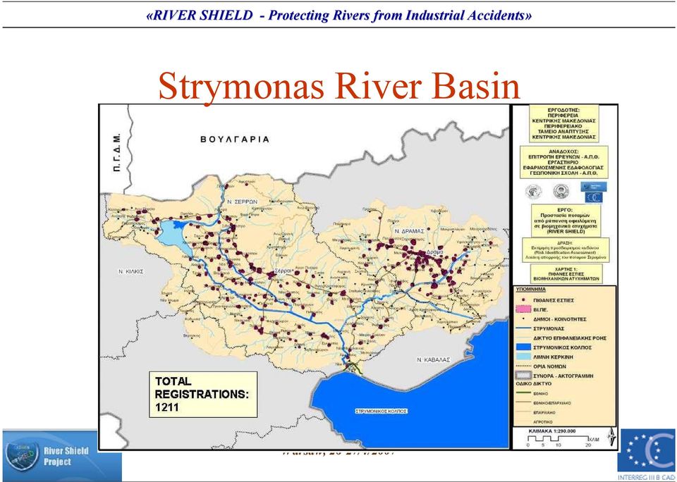
8 Strymonas River Basin Installations with WRC 3

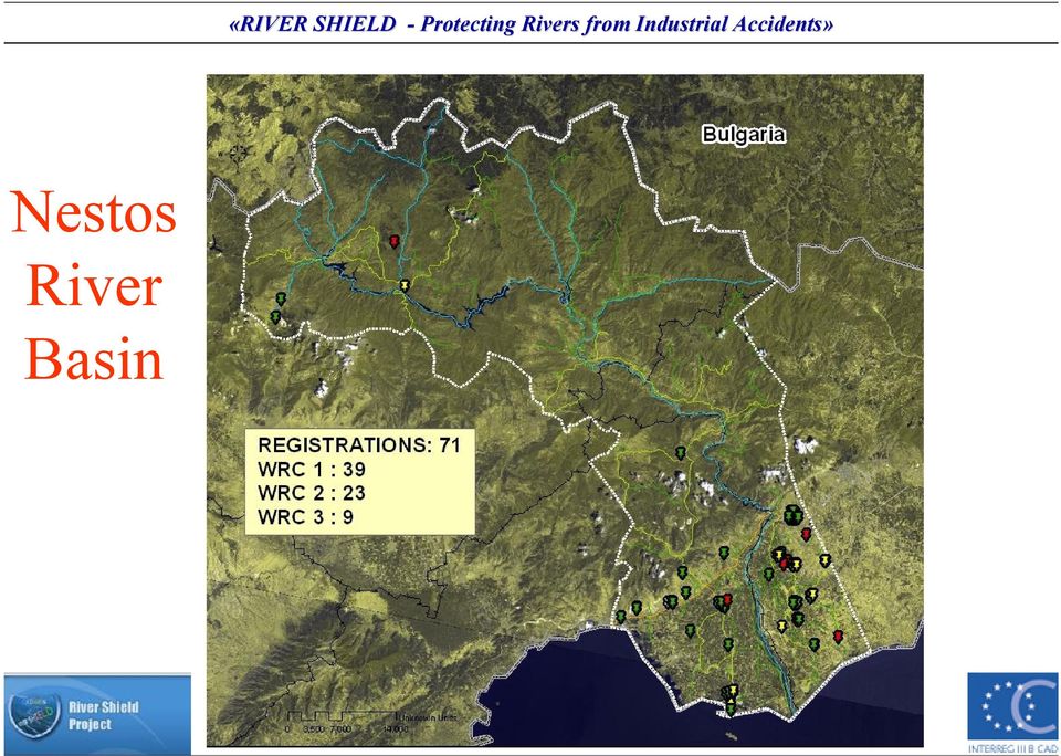
9 Nestos River Basin
10 On going action Spatial analysis of the risks in each river basin The outcome is thematic maps with high risk areas according to: Distance from the river Morphology of the surrounding area (subcachments)

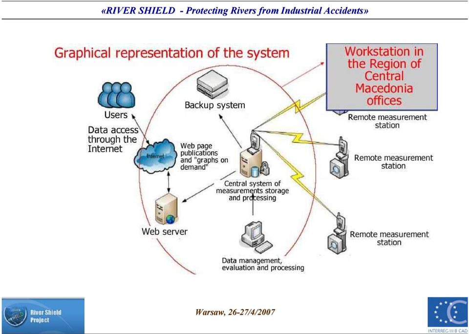
11 Early Warning System

12 Structure of Early Warning System 1. Collection and Transmission of field data in real time 2. Data management software (Department( of Electrical and Computer Engineering) 3. Decision Support System (cooperation with Department of Electrical and Computer Engineering)
 3.")
13
14 Measurement Stations in Strymonas River Basin

15 Measurement Stations in Nestos Installed station Proposed stations

16 Data Management Software Targets (1) Field data assessment (2) Near real time data (3) Easy access and distribution of results to authorities (4) Remote control of field station and synchronization
 Remote control of field station and")
17 Decision Support System

18 Decision Support System Procedure from risk recognition to system Characteristics of the measured parameters (with time- series methods) : q trend analysis q moving average q duration of change q other quality and quantity factors

19 Characteristics of Decision Support System Fuzzy rules describe in qualitati ative matter the incidents which may involve in time, and export the risk level The description of the amounts and the structure of the rules refer to human perception and decision making The base of the rules can be formed by experienced experts The base of the rules can be expanded or diverted including different scenarios that may happen.

20 Parameter analysis in DSS Parameters profile in each river: time period, day sequence seasonal changes weather conditions the appearance of high risk installation in the area

21 Thank you for your attention
Recovery of full cost and pricing of water in the Water Framework Directive
 Abstract Recovery of full cost and pricing of water in the Water Framework Directive D. Assimacopoulos Professor, Department of Chemical Engineering, NTUA The Water Framework Directive (EC 2000/60) introduces
PPC s Involvement in the Application of the WFD
 PPC s Involvement in the Application of the WFD 13 th International Conference Europe INBO 2015 Local Processes for the application of the Directives and the participation of local stakeholders Let us
Region of Central Macedonia
 Region of Central Macedonia AGRO_LESS Final Conference Thessaloniki 30-10-2015 2 Project Full title: «Joint reference strategies for rural activities of reduced inputs» Axis 1 Quality of life, Measure
Basin Management to Protect Ecosystem Health - Lessons from Estonia- Russian Cooperation
 Basin Management to Protect Ecosystem Health - Lessons from Estonia- Russian Cooperation Harry Liiv, Member of the Estonian-Russian Transboundary Water Commission General overview Estonia borders with
Standardized Runoff Index (SRI)
") Standardized Runoff Index (SRI) Adolfo Mérida Abril Javier Gras Treviño Contents 1. About the SRI SRI in the world Methodology 2. Comments made in Athens on SRI factsheet 3. Last modifications of the factsheet
Standardized Runoff Index (SRI) Adolfo Mérida Abril Javier Gras Treviño Contents 1. About the SRI SRI in the world Methodology 2. Comments made in Athens on SRI factsheet 3. Last modifications of the factsheet
MONITORING IRRIGATION SEASON - A SUPPORT TOOL FOR WATER MANAGEMENT AND SHORT-TERM ACTIONS
 OECD WORKSHOP ON IMPROVING THE INFORMATION BASE TO BETTER GUIDE WATER RESOURCE DECISION-MAKING 4-7 May, 2010, Zaragoza MONITORING IRRIGATION SEASON - A SUPPORT TOOL FOR WATER MANAGEMENT AND SHORT-TERM
HOW TO FUND BASIN MANAGEMENT PLANS? Invest in IWRM - it pays back!
 HOW TO FUND BASIN MANAGEMENT PLANS? Invest in IWRM - it pays back! Jean-François DONZIER Permanent Technical Secretary of the International Network of Basin Organizations (INBO), General Manager of the
New challenges of water resources management: Title the future role of CHy
 New challenges of water resources management: Title the future role of CHy by Bruce Stewart* Karl Hofius in his article in this issue of the Bulletin entitled Evolving role of WMO in hydrology and water
Water Management in Cuba: Problems, Perspectives, Challenges and the Role of the Cuban Academy of Sciences
 Water Management in Cuba: Problems, Perspectives, Challenges and the Role of the Cuban Academy of Sciences Daniela M. Arellano Acosta Environment Agency/ Water Commission, Academy of Science, CUBA Water
Annex 6 Recommendation on Safety Requirements for Contaminated Sites in Flood Risk Areas
 Support for the Extension of Accident Risk Spots Inventory and Preventive Measures / Final Report Annex 6 Recommendation on Safety Requirements for Contaminated Sites in Flood Risk Areas Final Draft International
QUANTITATIVE RISK ASSESSMENT FOR ACCIDENTS AT WORK IN THE CHEMICAL INDUSTRY AND THE SEVESO II DIRECTIVE
 QUANTITATIVE RISK ASSESSMENT FOR ACCIDENTS AT WORK IN THE CHEMICAL INDUSTRY AND THE SEVESO II DIRECTIVE I. A. PAPAZOGLOU System Reliability and Industrial Safety Laboratory National Center for Scientific
GROUNDWATER MONITORING AND DATA MANAGEMENT IN THE MEDITERRANEAN REGION. Marrakech, May 2005
 GROUNDWATER MONITORING AND DATA MANAGEMENT IN THE MEDITERRANEAN REGION Marrakech, May 2005 WATER RESOURCES IN THE MEDITERRANEAN REGION Water resources are limited, fragile and threatened Different conditions
Frequently Asked Questions (FAQs) on Hydropower
 on Hydropower") Frequently Asked Questions (FAQs) on Hydropower What are the advantages of Hydropower? A renewable source of energy - saves scarce fuel reserves. Non-polluting and hence environment friendly. Long life
Frequently Asked Questions (FAQs) on Hydropower What are the advantages of Hydropower? A renewable source of energy - saves scarce fuel reserves. Non-polluting and hence environment friendly. Long life
e-learning and the aspect of students in forestry and environmental studies.
 e-learning and the aspect of students in forestry and environmental studies. Ioannis V. Kirkenidis 1, Zacharoula S. Andreopoulou 2 Faculty of Agriculture, Forestry and Natural Environment Aristotle University
September 2008 onwards Technological Institute Of Serres, Greece Department of Geoinformatics and Surveying
 C U R RI C U L U M V I T A E I. PERSONAL INFORMATION Name Konstantinos NTOUROS Address 27 Ymittou str., 54453, Thessaloniki, Greece E-mail [email protected], [email protected] Nationality Greek
Survey and Mapping Activities in Vietnam *
 UNITED NATIONS E/CONF.100/CRP.1 ECONOMIC AND SOCIAL COUNCIL Eighteenth United Nations Regional Cartographic Conference for Asia and the Pacific Bangkok, 26-29 October 2009 Item 7(a) of the provisional
Data management, interpretation and diffusion in Austria
 Data management, interpretation and diffusion in Austria by Mediterranean Joint Process; Safir Heliopolitan Hotel, 1 Austria / Europe Umweltbundsamt GmbH the expert authority for environmental protection
WATER MANAGEMENT IN BULGARIA. Atanaska Tuntova [email protected] Director of East Aegean River Basin Directorate, Bulgaria
 WATER MANAGEMENT IN BULGARIA Atanaska Tuntova [email protected] Director of East Aegean River Basin Directorate, Bulgaria The national water management in Bulgaria has a long history Common state water
Department of Environmental Science and Technology. MSc in Energy Resource Management
 Department of Environmental Science and Technology MSc in Energy Resource Management Vision and Mission of the Department Vision The establishment of an internationally recognized Department in the field
Quality of Map-Matching Procedures Based on DGPS and Stand-Alone GPS Positioning in an Urban Area
 Quality of Map-Matching Procedures Based on DGPS and Stand-Alone GPS Positioning in an Urban Area Konstantinos LAKAKIS, Paraskevas SAVVAIDIS, Ioannis M. IFADIS and Ioannis D. DOUKAS, Greece Key words:
The elaboration of the Water Management Plan, state of progress and modalities
 The elaboration of the Water Management Plan, state of progress and modalities 1 1. Le Schéma d Amd Aménagement et de Gestion des Eaux - SAGE (Local Water Management Plan) A «new» tool in France for water
Abaya-Chamo Lakes Physical and Water Resources Characteristics, including Scenarios and Impacts
 LARS 2007 Catchment and Lake Research Abaya-Chamo Lakes Physical and Water Resources Characteristics, including Scenarios and Impacts Seleshi Bekele Awulachew International Water Management Institute Introduction
Impact of water harvesting dam on the Wadi s morphology using digital elevation model Study case: Wadi Al-kanger, Sudan
 Impact of water harvesting dam on the Wadi s morphology using digital elevation model Study case: Wadi Al-kanger, Sudan H. S. M. Hilmi 1, M.Y. Mohamed 2, E. S. Ganawa 3 1 Faculty of agriculture, Alzaiem
College of Agriculture, Engineering and Science INSPIRING GREATNESS
 School of Engineering College of Agriculture, Engineering and Science INSPIRING GREATNESS Don t accept what is, always ask what if. The School of Engineering is one of five Schools that form UKZN s College
Grades 3-5. Benchmark A: Use map elements or coordinates to locate physical and human features of North America.
 Grades 3-5 Students use knowledge of geographic locations, patterns and processes to show the interrelationship between the physical environment and human activity, and to explain the interactions that
GIS and Remote Sensing in Diachronic Study of Agriculture in Greece
 GIS and Remote Sensing in Diachronic Study of Agriculture in Greece Maria Androulidaki a, Michail Salampasis b, Vagis Samathrakis c, Christos Batzios d a Alexander Technology Educational Institute of Thessaloniki,
Concept Note for an IWRM Masters Degree Program. Armenia, Azerbaijan and Georgia 2012
 Concept Note for an IWRM Masters Degree Program 1. Summary of Action Armenia, Azerbaijan and Georgia 2012 The UNDP-GEF Kura Project has undertaken several stakeholder involvement and capacity building
Concept Note for an IWRM Masters Degree Program. Armenia, Azerbaijan and Georgia 2012
 Concept Note for an IWRM Masters Degree Program 1. Summary of Action Armenia, Azerbaijan and Georgia 2012 The UNDP-GEF Kura Project has undertaken several stakeholder involvement and capacity building
REPUBLIC OF TURKEY MINISTRY OF FORESTRY AND WATER AFFAIRS
 REPUBLIC OF TURKEY MINISTRY OF FORESTRY AND WATER AFFAIRS Turkey s position in the World Prof. Dr. Veysel EROĞLU Minister of Forestry and Water Affairs The Ministry of Forestry and Water Affairs, formerly
ASSIGNMENT OF ITM 613 DECISION SUPPORT SYSTEM
 ASSIGNMENT OF ITM 613 DECISION SUPPORT SYSTEM Lecture: Prof. Kudang B. Seminar, MSc, PhD By: DEDI PRIYANTO G051124031 BOGOR AGRICULTURAL UNIVERSITY MASTER OF SCIENCE IN INFORMATION TECHNOLOGY FOR NATURAL
REFLECTION ON MANAGEMENT OF WATER RESOURCES. Guido Heijdra MSc MCM CMC Associate Professor Water and Environmental Management
 REFLECTION ON MANAGEMENT OF WATER RESOURCES Guido Heijdra MSc MCM CMC Associate Professor Water and Environmental Management 1 CONTENT 1. Introduction 2. Water cycle 3. Water usage 4. Water stress in urban
Jemalong Irrigation Limited. Pollution Incident Response Management Plan
 Jemalong Irrigation Limited Pollution Incident Response Management Plan Pollution incidents must be reported immediately A pollution incident can be any of the following: An accident which involves any
Sediment and Dredged Material Management - Relevance and Objectives 18 September 2003
 - Relevance and Objectives 1. Scope of the Dutch German Exchange (DGE) The Netherlands and Germany have large river systems such as Danube, Rhine, Meuse, Elbe, Weser and Ems, which have important hydrological
ENVIRONMENTAL SCIENCE MANAGEMENT
 2009-2010 Graduate Bulletin 206 ENVIRONMENTAL SCIENCE MANAGEMENT The Department of Physical and Earth Sciences offers core courses and an area of concentration in environmental science management within
Remote sensing and GIS applications in coastal zone monitoring
 Remote sensing and GIS applications in coastal zone monitoring T. Alexandridis, C. Topaloglou, S. Monachou, G.Tsakoumis, A. Dimitrakos, D. Stavridou Lab of Remote Sensing and GIS School of Agriculture
USE OF GIS AS A REAL TIME DECISION SUPPORT SYSTEM FOR IRRIGATION DISTRICTS. Gabriele Bonaiti, Ph.D. 1 Guy Fipps, Ph.D., P.E.
 USE OF GIS AS A REAL TIME DECISION SUPPORT SYSTEM FOR IRRIGATION DISTRICTS Gabriele Bonaiti, Ph.D. 1 Guy Fipps, Ph.D., P.E. 2 ABSTRACT GIS technology has been utilized in the past years by drainage and
The key points of the 2013 Annual Compliance Report are described fully in the following sections of this report:
 Introduction Snowy Hydro Limited (Snowy Hydro) relies on precipitation falling over the catchments of the Snowy Mountains to supply water for the production of hydro-electricity. Cloud seeding over this
MICRO HYDRO FOR THE FARM AND HOME
 MICRO HYDRO FOR THE FARM AND HOME How much can I expect to save? This depends entirely on the available flow, available head (fall) and the duration that the flow is available. Some farms struggle to maintain
River Basin Management in Croatia
 River Basin Management in Croatia 2. INTERNATIONAL RIVER BASIN MANAGEMENT HIGH LEVEL SYMPOSIUM Cappadocia/NEVŞEHİR, Turkey 16-18 April 2013 2 Water sector responsibilities are shared among: Croatian Parliament
A quick overview of geographic information systems (GIS) Uwe Deichmann, DECRG <[email protected]>
 Uwe Deichmann, DECRG <udeichmann@worldbank.org>") A quick overview of geographic information systems (GIS) Uwe Deichmann, DECRG Why is GIS important? A very large share of all types of information has a spatial component ( 80
A quick overview of geographic information systems (GIS) Uwe Deichmann, DECRG Why is GIS important? A very large share of all types of information has a spatial component ( 80
DEVELOPMENT OF A WEB-BASED GIS MANAGEMENT SYSTEM FOR AGRICULTURAL AUTHORITIES IN IRAQ
 DEVELOPMENT OF A WEB-BASED GIS MANAGEMENT SYSTEM FOR AGRICULTURAL AUTHORITIES IN IRAQ Gabriele Bonaiti, Ph.D. 1 Dave Flahive 2 Guy Fipps, Ph.D., P.E. 3 ABSTRACT A Geographic Information System (GIS) is
Aiding the Hydro-scheme development process. Web-links to useful information sources
 Aiding the Hydro-scheme development process. Web-links to useful information sources Web-pages are in bold. These pages aim at providing developers, land-owners, decision makers and advisors with a collation
Building Caribbean GeoNode Platform in Support of Climate Risk Management Jacob Opadeyi, PhD
 Building Caribbean GeoNode Platform in Support of Climate Risk Management Jacob Opadeyi, PhD Our Highly Vulnerable Region Housing developments on drainage channels and steep slopes Unapproved development
EUROPEAN WATER RESOURCES AND POLICY
 EUROPEAN WATER RESOURCES AND POLICY What is the current water situation? The current water situation in Europe, according to a European Commission brochure, is described as: 20% of all surface water in
COMPARISON OF SOFTWARE FOR RESCUE OPERATION PLANNING DURING AN ACCIDENT IN A NUCLEAR POWER PLANT
 COMPARISON OF SOFTWARE FOR RESCUE OPERATION PLANNING DURING AN ACCIDENT IN A NUCLEAR POWER PLANT 3 Richetta 3 ABSTRACT This work has been developed to determine proper analytical support instruments in
Application of Space Technology for Disaster monitoring and assessment current state in Vietnam
 Application of Space Technology for Disaster monitoring and assessment current state in Vietnam Lai Anh Khoi SPACE TECHNOLOGY INSTITUTE 8th GEOSS Asian Pacific Symposium Beijing, Sep. 09-11, 2015 Types
Development of information management system of dams in China based on. WebGIS
 Development of information management system of dams in China based on WebGIS ZHU Xing-ming 1, GENG Qing-zhai 1,2 (1.China Institute of Water Resources and Hydropower Research, Beijing 100044, China, [email protected];
FLOOD PROTECTION AND ECOSYSTEM SERVICES IN THE CHEHALIS RIVER BASIN. May 2010. Prepared by. for the. 2010 by Earth Economics
 FLOOD PROTECTION AND ECOSYSTEM SERVICES IN THE CHEHALIS RIVER BASIN May 2010 Prepared by for the Execubve Summary The Chehalis Basin experienced catastrophic flooding in 2007 and 2009. In response, the
Danubius Basic NetWork
 Danubius Basic NetWork A Project from the Danube Region to Europe Presented by Gábor Till 1 A project initiated by the Hungarian National Directorate General for Disaster Management Involving all DRS states
INSPIRE Compliant Provision of Metrological Sensor Data at the IMIDA Murcia, Spain
 INSPIRE Compliant Provision of Metrological Sensor Data at the IMIDA Murcia, Spain Authors: Manuel Erena Arrabal, Grupo de Sig y Teledeteccion, IMIDA Juan Antonio Lopez Morales, Grupo de Sig y Teledeteccion,
International Cooperation in Water Management and Pollution Control in the Danube River Basin. Joachim Bendow ICPDR Executive Secretary
 1 International Cooperation in Water Management and Pollution Control in the Danube River Basin Joachim Bendow ICPDR Executive Secretary The Danube River Basin, a cultural and historical centre of Europe
Precision Agriculture. Lucas Rios do Amaral Professor FEAGRI/UNICAMP Agronomist, PhD.
 Precision Agriculture Lucas Rios do Amaral Professor FEAGRI/UNICAMP Agronomist, PhD. August 04 th 2015 Conventional agriculture Deal with the entire are as it is homogeneous.. ...but it never is. Corn
PREDICTIVE AND OPERATIONAL ANALYTICS, WHAT IS IT REALLY ALL ABOUT?
 PREDICTIVE AND OPERATIONAL ANALYTICS, WHAT IS IT REALLY ALL ABOUT? Derek Vogelsang 1, Alana Duncker 1, Steve McMichael 2 1. MWH Global, Adelaide, SA 2. South Australia Water Corporation, Adelaide, SA ABSTRACT
Pollution Incident Response Management Plan
 Pollution Incident Response Management Plan DOCUMENT CONTROL DOCUMENT DETAILS Title Pollution Incident Response Management Plan Reference Document Status ENV 002 12 Pollution Incident Response Management
12 ENERGY. 12.1 Introduction
 12 Energy 12.1 Introduction Otago is a hydro-electric power producing region and a major exporter of electricity in New Zealand today. The two large existing hydro-electric schemes in the region, Roxburgh
Social cost-benefit analysis of the soil remediation operation in the Netherlands
 Social cost-benefit analysis of the soil remediation operation in the Netherlands A.P. van Wezel et al, 2007. The Netherlands Environmental Assessment Agency, MNP report 500122002/2007 (Dutch). Summary
DISASTER RISK DETECTION AND MANAGEMENT COURSES SETUP SCENARIO AT MAKERERE UNIVERSITY. Makerere University
 DISASTER RISK DETECTION AND MANAGEMENT COURSES SETUP SCENARIO AT MAKERERE UNIVERSITY CASE OF THE DEPARTMENT OF GEOGRAPHY Derek Muhwezi 2 MISSION OF THE DEPARTMENT To provide and promote quality education,
GEOSPATIAL DIGITAL ASSET MANAGEMENT A SOLUTION INTEGRATING IMAGERY AND GIS WHERE WILL ALL THE PIXELS GO?(AND HOW WILL WE EVER FIND THEM?
 GEOSPATIAL DIGITAL ASSET MANAGEMENT A SOLUTION INTEGRATING IMAGERY AND GIS WHERE WILL ALL THE PIXELS GO?(AND HOW WILL WE EVER FIND THEM?) Dr. Joan Lurie, GCC, Inc. 30 West 61 st Street, Apt 9A New York,
International Data Centre for Hydrology of Lakes and Reservoirs (HYDROLARE)
") Sengupta, M. and Dalwani, R. (Editors). 2008 Proceedings of Taal 2007: The 12th World Lake Conference: 2258-2262 International Data Centre for Hydrology of Lakes and Reservoirs (HYDROLARE) T.P. Gronskaya,
Sengupta, M. and Dalwani, R. (Editors). 2008 Proceedings of Taal 2007: The 12th World Lake Conference: 2258-2262 International Data Centre for Hydrology of Lakes and Reservoirs (HYDROLARE) T.P. Gronskaya,
CHAPTER 3 GIS DATABASE
 The Study on Integrated Water Management Draft Final Report CHAPTER 3 GIS DATABASE 3.1 Introduction The project objective, concerning GIS as stated in the Inception and Interim Report, is the development
DEPARTMENT OF GEOGRAPHY
 KENYATTA UNIVERSITY SCHOOL OF HUMANITIES AND SOCIAL SCIENCES DEPARTMENT OF GEOGRAPHY BACHELOR OF EDUCATION PROGRAMME For a student to be registered for the Degree of Bachelor of Education in Geography,
Distributed Database for Environmental Data Integration
 Distributed Database for Environmental Data Integration A. Amato', V. Di Lecce2, and V. Piuri 3 II Engineering Faculty of Politecnico di Bari - Italy 2 DIASS, Politecnico di Bari, Italy 3Dept Information
FREE and open source tools for WATer resource
 FREE AND OPEN SOURCE SOFTWARE FOR GEOSPATIAL: TOWARD DIVERSITY! SEPTEMBER 14TH - 19TH 2015, SEOUL FREE and open source tools for WATer resource Massimiliano Cannata, Rudy Rossetto, Iacopo Borsi, Laura
(1) Discuss the determination of the need for public visitation. Visitor center density within 100 miles.
 Discuss the determination of the need for public visitation. Visitor center density within 100 miles.") Chapter 4 Specifications Designs 3. Visitors Centers 3. Visitors Centers. The Introduction (Chapter 1) for these design data collection guidelines contains additional information concerning: preparing
Chapter 4 Specifications Designs 3. Visitors Centers 3. Visitors Centers. The Introduction (Chapter 1) for these design data collection guidelines contains additional information concerning: preparing
Water Demand Forecast Approach
 CHAPTER 6 2009 REGIONAL WATER SUPPLY OUTLOOK Water Demand Forecast Approach 6.1 Introduction Long-range water demand forecasting is a fundamental tool that water utilities use to assure that they can meet
EFAS European Flood Awareness System
 EFAS European Flood Awareness System http://www.efas.eu/ EFAS Partner Network The first operational hydrological network in Europe Cristina Alionte Eklund Coordinator EFAS Dissemination Center History
APPLICATIONS OF GIS IN INFRASTRUCTURE PROJECT MANAGEMENT
 Int. J. Struct. & Civil Engg. Res. 2013 Sandip N Palve, 2013 Research Paper ISSN 2319 6009 www.ijscer.com Vol. 2, No. 4, November 2013 2013 IJSCER. All Rights Reserved APPLICATIONS OF GIS IN INFRASTRUCTURE
INDONESIA - LAW ON WATER RESOURCES,
 Environment and Development Journal Law LEAD INDONESIA - LAW ON WATER RESOURCES, 2004 VOLUME 2/1 LEAD Journal (Law, Environment and Development Journal) is a peer-reviewed academic publication based in
Exploring the potential of energy recovery using micro hydropower systems in water supply systems
 Water Utility Journal 7: 25-33, 2014. 2014 E.W. Publications Exploring the potential of energy recovery using micro hydropower systems in water supply systems I. Kougias *, T. Patsialis, A. Zafirakou and
Precipitation Monitoring Network:
 The Caribbean Drought and Precipitation Monitoring Network: Adrian R. Trotman Caribbean Institute for Meteorology and Hydrology CARIWIN Regional Seminar 14-15 January, 2010 Georgetown, Guyana Why Plan
GPS Use in U.S. Critical Infrastructure. and Emergency Communications. Presented to the
 GPS Use in U.S. Critical Infrastructure and Emergency Communications Presented to the DOT, DoD, and DHS United States Technical Training Institute (USTTI) Presenter Monty Graham Program Manager GPS Jamming
Best Practice LCA Water assessment methods. Daniel Thylmann [email protected]
 Best Practice LCA Water assessment methods Daniel Thylmann [email protected] 02.12.2014 Web conferencing software Expand & collapse your control menu Audio options Welcome to the webinar!
RURAL AND AGRICULTURE FINANCE Prof. Puneetha Palakurthi School of Community Economic Development Sothern New Hampshire University
 RURAL AND AGRICULTURE FINANCE Prof. Puneetha Palakurthi School of Community Economic Development Sothern New Hampshire University DRIVERS OF RURAL DEVELOPMENT High overall economic growth Effective land
ARIZONA DEPARTMENT OF WATER RESOURCES
 ARIZONA DEPARTMENT OF WATER RESOURCES WATER MANAGEMENT REQUIREMENTS FOR SOLAR POWER PLANTS IN ARIZONA ADWR CONTACT: Jeff Tannler, Statewide Active Management Area Director Arizona Department of Water Resources
E-learning at ITC. Project group E-learning ITC Ineke ten Dam INTERNATIONAL INSTITUTE FOR GEO-INFORMATION SCIENCE AND EARTH OBSERVATION
 E-learning at ITC Project group E-learning ITC Ineke ten Dam INTERNATIONAL INSTITUTE FOR GEO-INFORMATION SCIENCE AND EARTH OBSERVATION Main items What is ITC? Why e-learning at ITC? Multi-usable courseware
Methods of Technical Risk Assessment in a Regional Context
 Methods of Technical Risk Assessment in a Regional Context Principles and methods for risk evaluation Wolfgang Kröger, Professor and Head of former Laboratory for Safety Analysis (www.lsa.ethz.ch) Founding
Quotas of Master Degree. Quotas of PhD. Yearly Fee. Institute and Master Program. Condition. Institute of Natural and Applied Sciences
 Institute and Master Program Quotas of Master Degree Quotas of PhD Condition Yearly Fee Institute of Natural and Applied Sciences Archeometry 2 Horticulture Master: Those who have not graduated from one
Master Plan on Water Resource Management
 Master Plan on Water Resource Management Strategic Committee for Water Resource Management Office of the Strategic Committee for Water Resource Management Office of the National Economic and Social Development
Overview of NASA Applied Remote Sensing Training Program on Water Resources and Disaster Management
 Overview of NASA Applied Remote Sensing Training Program on Water Resources and Disaster Management ARSET Applied Remote SEnsing Training A project of NASA Applied Sciences Outline About ARSET ARSET Trainings