CONTENTS INTRODUCTION... 1 UNIT 1. PURPOSE OF MAPS MAP DEFINITION 1.2 MAP ACCURACY UNIT 2. CLASSIFICATION OF MAPS CATEGORIES 2.
|
|
|
- Crystal Lynette Henry
- 10 years ago
- Views:
Transcription
1 CONTENTS INTRODUCTION... 1 UNIT 1. PURPOSE OF MAPS MAP DEFINITION 1.2 MAP ACCURACY UNIT 2. CLASSIFICATION OF MAPS CATEGORIES 2.2 U.S. GEOLOGICAL SURVEY UNIT 3. MAP LEGEND MAP SCALES 3.2 CARDINAL DIRECTIONS 3.3 MAP LEGEND 3.4 REVISION DATE 3.5 REPRESENTED COLORS 3.6 ADJOINING MAPS 3.7 ICS SYMBOLOGY UNIT 4. GRID LOCATION SYSTEM ROAD ATLAS UNIT 5. RECTANGULAR LAND DESCRIPTION SYSTEM A INITIAL OR REFERENCE POINT 5.1B CORRECTION LINES 5.1C TOWNSHIPS AND RANGES 5.1D SECTIONS 5.2 LATITUDE AND LONGITUDE 5.3 UNIVERSAL TRANSVERSE MERCATOR (UTM) 5.4 OTHER LAND DESCRIPTION SYSTEMS UNIT 6. DETERMINING SIZE OF AREA BASIC MATHEMATICAL CALCULATIONS 6.2 ESTIMATION BY COMPARISON UNIT 7. TOPOGRAPHIC RELIEF CONTOUR LINES 7.2 CROSS-SECTIONING LANDSCAPE PROFILES UNIT 8. SLOPE PERCENT SLOPE 8.2 SLOPE MEASUREMENTS FROM FIELD OBSERVATIONS i
 5.4 OTHER LAND DESCRIPTION SYSTEMS UNIT 6. DETERMINING SIZE OF AREA... 33 6.1 BASIC MATHEMATICAL CALCULATIONS 6.2 ESTIMATION BY COMPARISON UNIT 7.")
2 UNIT 9. DETERMINING DISTANCE PACING 9.2 DETERMINING YOUR PACE ON SLOPING GROUND 9.3 VISUALLY ESTIMATING DISTANCE AND OTHER METHODS UNIT 10. COMPASS FAMILIARITY PARTS OF A COMPASS 10.2 MAGNETIC DECLINATION 10.3 USING YOUR COMPASS 10.4 THE COMPASS AS A PROTRACTOR 10.5 ORIENTING A MAP WITH A COMPASS 10.6 BACK AZIMUTH AND BACKSIGHT 10.7 INTERSECTION 10.8 RESECTION GLOSSARY ANSWERS TO UNIT TESTS AND EXERCISES FINAL EXAMINATION ii

3 INTRODUCTION Maps have long been an integral element in incident support. From urban incidents to wildland operations, maps have provided information necessary to perform required tasks. The importance of maps takes on an even greater significance when considering the growing population and the rapid changes to our environment. In order to plan for and respond to various incidents, an understanding of maps becomes essential for making intelligent decisions. This self-study course was prepared specifically to introduce you to the basics of map interpretation, compass use, and familiarize you with the United States Geological Survey (USGS) topographic maps, and planimetric maps. Take the time to go through this course at your own pace. It should take between three and eight hours to complete the text, depending on your previous experience and knowledge. Completely understand each unit before you proceed to the next. The course gives you an opportunity to check your comprehension as you progress through the text. Questions and answers are provided at the end of each unit. After completing this course, you will have the knowledge to read maps and use the compass effectively. Learning experiences from the course text are limited. It is recommended you practice in the field to enhance the fundamentals you have learned. MATERIALS NEEDED FOR THE COURSE: 12" or 18" clear plastic rule (1/10 inch graduations) clinometer (graduated in degrees and percent) Silva Ranger compass (360 degree rose), or equivalent protractor (360-degree preferred) calculator dot grids or acreage overlay tranparencies (optional) 1
 topographic")
4 2

5 UNIT 1 PURPOSE OF MAPS 1. PURPOSE OF MAPS A map is designed for the purpose of permitting you to visualize a portion of the earth's surface with pertinent features properly positioned to facilitate planning and organizing operations. Different types of maps are used for different purposes. One map with all the details of several types of maps would be so cluttered that it would make reading and interpretation difficult. 1.1 Map Definition A map is a line drawing, to some scale, of an area of the earth's surface. It shows objects and features by conventional signs. A map is a graphic representation of a portion of the earth s surface, drawn to scale on a plane. 1.2 Map accuracy The accuracy of a map is important. A point or symbol marked on a map must be in proper relation to known landmarks or positions located on the ground in order for the map to be considered reliable. As a result, the "United States National Map Accuracy Standards" were established as the standards of accuracy for published maps. These were issued in 1947 to all Federal agencies producing maps and are currently in effect. The standards require a stringent percent of accuracy within centimeters of both location and elevation points tested. Cartographers and editors check all maps thoroughly and attempt to keep factual errors to the required standard. However, map accuracy is imperfect for two main reasons: 1. Representational inaccuracy Maps, although drawn to a scale, are not absolutely accurate because they represent a curved and uneven surface on a flat piece of paper. If you drew a picture on the surface of a sphere, such as an orange, and then peeled the orange and flattened the peel, the picture now would be distorted. Compensating for the roundness of the world on a flat surface is a difficulty encountered by early map makers. Factual matters are also subject to errors, such as, names, symbols of features, and the classifications of roads or woodlands. Map makers have to rely on local sources for their information. Sometimes the information is wrong. Sometimes names change or new names and features are added in an area. 2. Measurement error Most of the original surveys undertaken during the first U.S. Public Land Survey were performed under very difficult conditions. The majority of these surveys were well done, but there was a margin of inaccuracy because of human error and inadequate survey procedures and equipment used by the initial surveyors. 3

6 UNIT 1 QUESTIONS 1. What is the purpose of a map? 2. List two reasons why maps may be inaccurate in their representation. A. B. 3. Why did some measurement error occur in the original surveys? 4

7 UNIT 2 CLASSIFICATION OF MAPS 2. CLASSIFICATION The maps discussed in this text are maps used to depict the features of an area. These maps fall into three categories: 2.1 Categories 1. Planimetric Maps Show the positions of features without showing their relationship to the hills and valleys of the land. They can include rivers, lakes, roads, boundaries, or other human-made, symbolic features. For example: a. Common road maps Road atlas, street maps, and Thomas Guides. b. Specific area maps Preplan maps, floor plan maps, storm drain, sewer and water system maps. c. Schematic maps Agency maps: unit, aviation, resource, district response maps. 2. Topographic Maps Shows both the horizontal and vertical (relief) positions of features. Topographic maps are often referred to as quadrangles or quads. For example: a. Contour maps - are the most common method of representing the shape and elevation of the land. A contour is a line of equal elevation on the ground that delineates the same elevation above or below a specific reference elevation, usually sea level. b. Shaded-relief maps - are pictorial. They are shaded to simulate sunlight on the terrain. This shadow effect accentuates the shape of the physical features. 3. Orthophoto Maps An orthophoto map is a map depicting terrain and other features by colorenhanced photographic images. It is an aerial photograph of the land. Some orthophoto maps are overlain with contour lines and other features commonly 5
 positions of features.")
8 associated with topographic maps. These maps are corrected for scale and are the same size as U.S.G.S. quads. 2.2 The United States Geological Survey The United States Geological Survey of the Department of the Interior is engaged in topographic and geologic mapping and in collection of information about the public lands. Many of the contour maps we use have been produced by the U.S.G.S. For incidents on U.S. Forest Service land, consider using topographic maps made by the Forest Service. They are generally more current than U.S.G.S. maps. 6

9 UNIT 2 QUESTIONS 1. List the three categories of maps. 2. List three examples of planimetric maps. 3. List the two types of topographic maps. 7

10 8

11 UNIT 3 MAP LEGEND 3. MAP LEGEND A legend shows information needed to interpret a map. Each type of map has information represented in a different way relating to its subject matter. The legend can explain map scales, symbols and color. 3.1 Map Scale The map scale indicates the ratio or proportion of the horizontal distance on the map to the corresponding horizontal distance on the ground. A representative fraction (R.F.) scale expresses the ratio of the map distance to the ground distance in like units of measurements. It is usually written as a fraction or ratio. A representative fraction is always written with the map distance as 1 (one). A representative fraction of 1/24,000 (1:24,000) means that one UNIT of measurement (inches, millimeters, feet, etc.) on the map is equal to 24,000 of the SAME UNITS on the ground. You CANNOT mix units in a representative fraction. If it is one INCH on the map, it is 24,000 INCHES on the ground. EXAMPLE: R.F. is map distance = 1" OR 1:24,000 ground distance 24,000" The larger the representative fraction (the fraction 1 divided by 24,000 is obviously larger than 1 divided by 250,000), the larger and clearer the details shown on it. But on the other hand, the larger the fraction, the smaller the area covered by the same size map sheet. A graphic scale (G.S.) or comparison scale is entirely different. It usually COMPARES map distances to the ground distance in DIFFERENT units of measurements. Usually a graphic scale is a line marked off on a map indicating so many inches or millimeters equal so many feet, kilometers, chains, or miles on the ground. A comparison scale of 1" to 2000 feet means that 1 (one) inch on the map is proportioned to 2000 feet on the ground. We are comparing inches and feet which are DIFFERENT UNITS of measurement. EXAMPLE: G.S. is map distance to ground distance 1" to 2000 feet 9
 scale expresses the ratio of the map distance to the ground distance in like units of measurements. It is usually written as a fraction or ratio.")
12 If the map scale is not given, you can determine it as follows: 1. Locate two points on the map that you can also see on the ground. 2. Measure the distance between the points on the map. 3. Measure the distance between the points on the ground. 4. Divide the ground distance by the map distance, in the same units, and record the answer as 1 : (answer) ; This is the map scale. Example: Map distance = 2 inches; Ground distance = 4,000 feet (48,000 inches) 48,000 2 = 24,000. Record as 1 : 24,000. The map scale is 1 : 24,
 48,000 2 = 24,000. Record as 1 : 24,000.")
13 3.2 Cardinal Directions It is common practice for maps to be oriented with north at the top. Most maps have a symbol of an arrow pointing to the north. It is then understood east is right, west is left and south is bottom of the map. 3.3 Map Legend Most maps have a legend to help interpret the map. Legends describe map symbols, such as what color line delineates a road or land ownership boundary, or what figure represents a building, stream, spring, or heliport. Map symbols are not the same for every map. They change from map type to map type. However, you can find some symbols the same on various maps. 3.4 Revision Date Some maps have a revision date, which is when the map was last updated to reflect changes. If the map is very old, it may not be very accurate. 11

14 3.5 Represented Colors In order to make the identification of features on a map easier to interpret and to provide more natural appearance and contrast, map symbols are usually printed in colors with each color representing a class of features. The colors are as follows: 1. BLACK - Most cultural or human-made features, boundaries. 2. BLUE - Water features such as lakes, rivers, or swamps. 3. GREEN - Vegetation such as woods, orchards, or vineyards. 4. BROWN - All relief features, contours, cuts and fills (Topographic maps). 5. RED - Main roads, built-up areas, boundaries, special features. 6. Other colors may be used for special purposes. Their key will be found in the margin/legend of the map. 3.6 Adjoining Maps Some areas are too large to be shown on a single map. Adjoining maps are frequently indicated in the margins of USGS topographical maps, or by an adjoining quadrangle legend on the map. A Topographical Map Index circular contains a map of the state divided into quadrangles. If you are working on a large incident, you can use the Index circular to help you identify and order topographical maps that you might need. 12

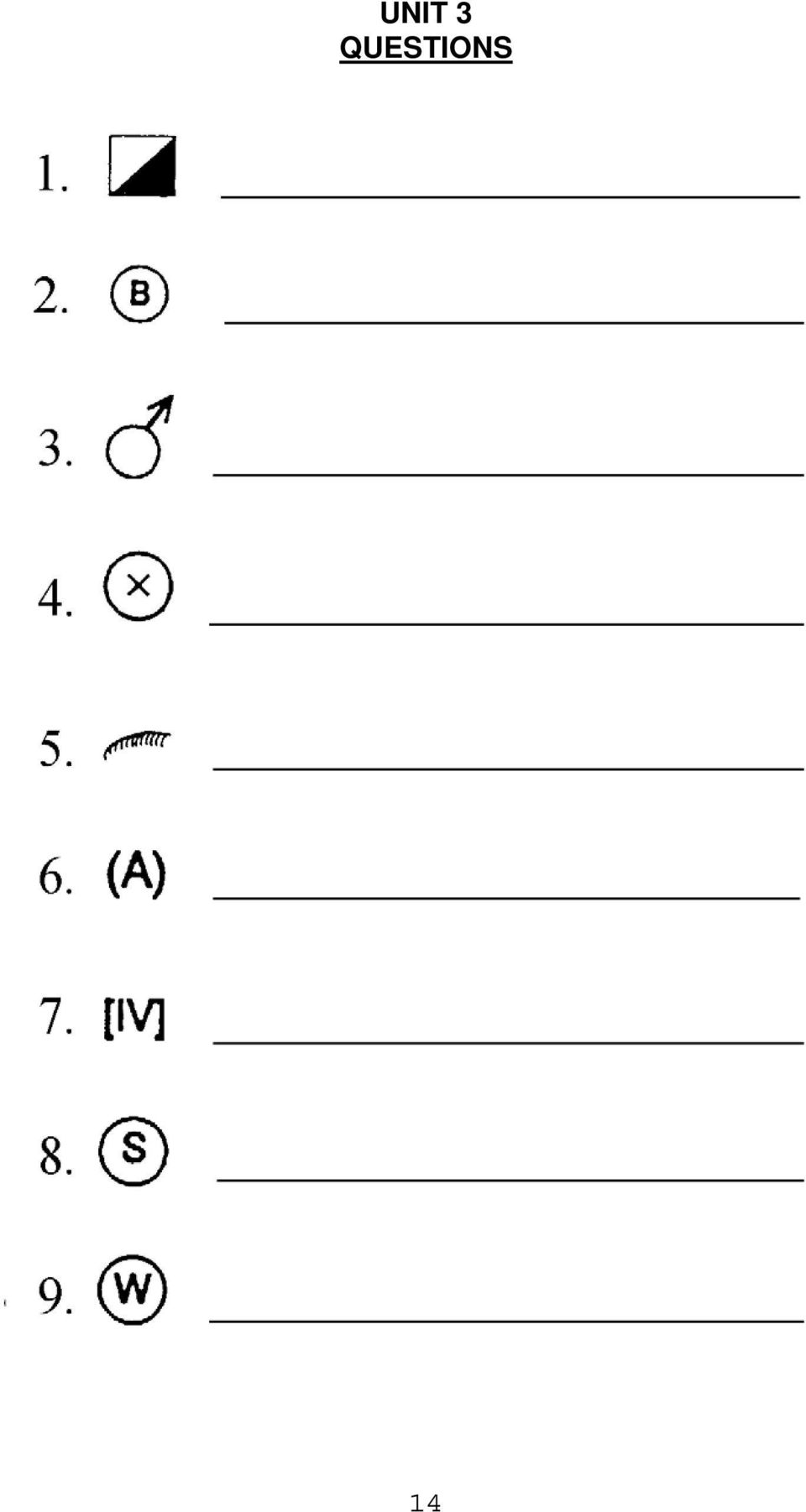
15 3.7 ICS Display Symbols The Incident Command System uses a standardized, color-coded symbol set. ICS map symbols are not commonly used by the public. The interpretation and drafting of maps with the ICS map symbology will be required for those trainees working on most emergency incidents and prescribed fires. ICS SYMBOLS EXERCISE IDENTIFY THE ICS SYMBOLS BELOW 13

16 UNIT 3 QUESTIONS 14
17 1. In general, what does a legend show? 2. Referring to a map scale, describe a representative fraction and give an example: 3. What is a graphic scale on a map? Give an example: 4. What are the five most common colors found on a U.S.G.S topographic map and what features do those colors represent? A. B. C. D. E. 5. If you had three different types of maps, could you use the same symbol key for all of them? Why or why not? 6. What cardinal direction is usually indicated at the top of map? Bottom of a map? Right of map? Left of map? 15

18 16

19 UNIT 4 GRID LOCATION SYSTEM 4. GRID SYSTEM A grid is a network of evenly spaced horizontal and vertical bars or lines intended for defining areas. When placed over a map, a system is created which helps you find a specific location. Some planimetric maps use this system to locate streets or other features. Grids are usually identified alpha-numerically. However some maps may use only letters or only numbers. These identifiers are placed horizontally and vertically along the edge of the grid, when matched together they identify all the blocks created in the grid. An index listing names, subjects, etc., together with page numbers and/or alphanumerical identifiers is usually available with the map grid. It is either at the bottom of the map or at the back of the map book. Given the name of what you want to locate, the index will direct you to the location on the map. TYPICAL GRID Example: Kington is located in 2E or E2. Many road maps are gridded like this. 17

20 4.1 Road Atlas A road atlas is one of the most commonly used general purpose maps. "The Thomas Brothers Maps" road atlas is a popular street atlas. An atlas contains much information such as: key map and general charts, cities and communities index, highway and detail street maps, driving tours and index listings of streets, highway, interstates and points of interest. In order to use your road atlas to its potential you must be completely familiar with its contents and how to use it. Read through your atlas and learn all of its components. The "Key Map" located at the front of the road atlas is the primary guide, and gives an overall picture of the area. It is an artery map of the entire area, designating the most direct route from one community or state to another. The Key Map also shows the designated page number of each map in the atlas. The individual map pages are then defined with the grid locating system, providing an easy-to-use order. UNIT 4 QUESTIONS 1. What is a Grid Locating System? 2. How are blocks within a grid identified? 3. What is the purpose of a map index? 4. Explain the "Key Map" located at the front of a road atlas. 18

21 UNIT 5 RECTANGULAR LAND DESCRIPTION SYSTEM 5.1 RECTANGULAR LAND DESCRIPTION SYSTEM The United States System of Surveying the Public Lands, frequently referred to as the rectangular system, was planned in 1784 by the Continental Congress and has survived until today with only minor modifications. The law requires: "Public lands shall be divided by North and South lines and by other lines running East and West so as to form Townships 6 miles square (not 6 square miles, but a square of 6 miles on each side, with an area of 36 square miles). Also the Townships will be divided into 36 sections, and each will contain 640 acres (AS NEARLY AS POSSIBLE)". Similar systems are in use in much of Canada, parts of Australia, and a few other areas of the world. 5.1A Initial Or Reference Point Rectangular land division is based on an Initial Point (also called Reference Point). There are 31 of these Initial Points in the conterminous U.S. All standard lines representing land divisions are based on two Reference Lines: 1. The imaginary line on the ground running east-west through the initial point is called the "Base Line". 2. The imaginary line on the ground running north-south through the initial point is called the "Principal Meridian". 19
22 5.1B Correction Lines Because of the curvature of the earth, additional lines called "Guide Meridians" and "Standard Parallels" are established from each Initial Point: 1. Standard Parallels are established in the same manner as the base line and are located at intervals of 24 miles north and south of the base line. The Parallels north of the Base Line are designated First Standard Parallel North, Second Standard Parallel North, etc., and those south as First Standard Parallel South, etc. 2. Guide Meridians are established in a similar manner as the Principal Meridian. The Meridians east of the Principal Meridian are designated First Guide Meridian East, Second Guide Meridian East, etc., and those west as First Guide Meridian West, etc. Guide Meridians converge because of the curvature of the earth, so the distance between these lines will be 24 miles only at the starting point. STANDARD PARALLELS AND GUIDE MERIDIANS Subdivision into 24-mile tracts. 20
23 5.1C Townships And Ranges Township Lines are the series of lines, 6 miles apart, which run east and west parallel to the Base Line. The area between the Base Line and the first Township Line on the south side is called Township 1 South. The area between the first and second Township lines on the south is Township 2 South, and so on. The numbering on the north side of the Base Line is the same. Range Lines are the series of lines, 6 miles apart, which run north and south parallel to the Principal Meridian. The areas between these lines are numbered much the same as the Township areas. The area between the Principal Meridian and the First line on the east side is Range 1 East. The area between the first and second lines on the east side is Range 2 East. The numbering on the west side of the Principal Meridian is the same. Proper descriptions of locations have the Township written first followed by the Range and Reference Point (T1N, R3E, SBBM). Township and Range descriptions are located in the margins and within the map. 21
24 5.1D Sections Townships are subdivided into 36 parts, each one mile square (as near as may be), called Sections. The typical numbering system of the Township is started in the upper right-hand corner, moving across to the left, down and to the right, etc. If you remember that the upper right hand corner is always Number 1 and that the numbers move back and fourth to the bottom you will be able to locate section numbers as necessary. Each number identifies a section (square area) which is usually one square mile and contains 640 acres. Sections do not always contain 640 acres, nor are they always one square mile. A properly written section location description would read: Section (Sec.) 22, T.5N., R.7W. 22
25 5.1D Cont. Division of sections - A typical section of 640 acres may be broken down into smaller areas, each successive smaller piece having a unique location description of its own. Example 1: Example 2: The areas broken down to 1/2 sections of 320 acres would be described as: Example 1; Area "A" - W1/2, Sec.22, T.5N., R.7W., M.D.B.&M. Area "B" - E1/2, Sec.22, T.5N., R.7W., M.D.B.&M. Example 2; Area "C" - N1/2, Sec.22, T.5N., R.7W., M.D.B.&M. Area "D" - S1/2, Sec.22, T.5N., R.7W., M.D..B.&M. Example 3: Example 4: The areas broken down into 1/4 sections of 160 acres would be described as: Example 3; Area "A" Area "B" Area "C" Area "D" NW1/4, Sec.22, T.5N., R.7W., M.D.B.&M. NE1/4, Sec.22, T.5N., R.7W., M.D.B.&M. SW1/4, Sec.22, T.5N., R.7W., M.D.B.&M. SE1/4, Sec.22, T.5N., R.7W., M.D.B.&M. 23
26 If you have two separate portions of a section to describe, use "and" as a connector in the description, as in Example 4: Area "A" N1/2 and SW1/4 SE1/4, Sec.22, T.5N., R.7W., M.D.B&M. The quarter sections can further be divided into half (80 acres) or quarter of the quarter (40 acres). This division of quarters or halves of a divided area, can be continued until broken down to a reasonable size of 10 acre parcels (on one-half inch equals one mile maps) and 2-1/2 acre parcels (on one inch equals one mile or larger scale). The illustration below shows an area of the section broken down into 2-1/2 acre parcels. Notice the parcels at the bottom labeled "A" and "B" The areas broken down into parcels of 2-1/2 acres would be described as: Area "A" - SW1/4 SW1/4 SW1/4 SE1/4, Sec-22, T.5N., R7W.,M.D.B.&M Area "B" - SE1/4 SW1/4 SW1/4 SE1/4, Sec-22, T.5N., R7W.,M.D.B.&M. 5.2 Longitude and Latitude - The earth s globe has a division system which identifies geographical positions precisely by reference to imaginary lines running pole to pole, and around the globe starting at and parallel to the equator. 24
27 Longitude lines run true north to true south - North Pole to South Pole. The lines are based from the Prime Meridian which is 0 degree longitude, and which runs through Greenwich England. Beginning with the Prime Meridian, they are numbered both east and west for 180 degrees. Lines of longitude are not parallel; the closer they are to the poles, the smaller the distance between them. Principal Meridian Lines run in the same direction as the lines of longitude. Latitude lines circle the world parallel with the equator, running in an easterly and westerly direction. These lines are identified by their position either north or south of the equator. The equator is 0 degree latitude. The degrees of latitude increase as one proceeds from the equator toward either north or south poles where the latitude is 90 degrees. Some maps such as the U.S.G.S. Topography Map indicate longitude and latitude. Tick marks at the top or bottom of a map, numbered with degrees ( ), minutes (') and seconds ("), indicate longitude. Similar tick marks at the sides indicate latitude. Crossmarks are noted where lines of latitude intersect with lines of longitude. 5.3 Universal Transverse Mercator (UTM) Universal Transverse Mercator is a rectangular coordinate system of determining location on the Earth s surface, similar to latitude-longitude, but is defined in meters rather than degrees-minutes-seconds. UTM is commonly used in global positioning system (GPS) and geographic information system (GIS) mapping, as it allows for a high degree of precision. UTM assumes a number of converging lines running from the equator to the poles - similar to lines of longitude - called zone lines, and uses two components, NORTHING and EASTING, to determine location. Within each zone is superimposed a square grid, 25
28 and although the zone lines converge toward the poles, the grid lines do not. Therefore, as one travels north from the equator, the grid becomes smaller, although the grid squares remain the same. For any given position in the northern hemisphere: NORTHING is the distance in meters of the position north of the equator, measured along a zone line; and EASTING is the distance in meters of the position east of the zone line. FOR EXAMPLE: Let us take a position in Montana described as UTM (the northing), (the easting), zone 12. The physical location of this position is 5 million, 346 thousand, 782 meters north of the equator, along the 12th zone line, and 683 thousand, 456 meters east of the 12th zone line. UTM is a very precise method of defining geographic locations; even our example, without decimals, defines the position to within one meter in each direction. For the purposes of comparison, one degree of latitude equals about 69 miles or 110,000 meters; one second of latitude equals about 30 meters. 26
29 5.4 Other Land Division Systems Although the Rectangular System of Survey is the official method of land description in the U.S., other systems are also legal land divisions: 1. Spanish Land Grants - In the southwestern United States, a township frequently will be occupied partially by a Spanish Grant. United States Government Surveys do not cover such grants, going only to and including their boundaries. For field references you can just continue known township and range lines into the grant and use the rectangular legal description. 2. Metes and bounds - In the Eastern United States this is a common method of land division. Metes and bounds is a system of establishing boundaries of tracts of land by reference to natural or artificial monuments along it, as distinguished from those established by beginning at a fixed starting point. 3. State Land Coordinate Systems - Established in several western states, these systems were developed to precisely measure and record boundary lines, monuments, and other features. 27
30 28
31 UNIT 5 QUESTIONS 1. What is the name of the point on which a rectangular land division is based? 2. What is the east-west line through the "point" called? 3. What is the north-south line through the "point" called? 4. How many square miles are within a township? _ 5. What does each numbered subdivision within a township identify? _ 6. Generally, how many acres in a section? 7. In which direction do lines of longitude run? 8. In which direction do lines of latitude run? 9. The lines that parallel the Baseline at 6 mile intervals are called lines. 10. The lines that extend the same direction as the Principal Meridian at 6 mile intervals are called lines. 29
32 UNIT 5 EXERCISE 1 1. Identify the Township areas and write their correct description: 2. Number the Sections in this typical Township: 30
33 UNIT 5 EXERCISE 2 3. Identify the correct "Township and Range" locations indicated with a "T and "R in the spaces below. Note the examples. 31
34 UNIT 5 EXERCISE 3 4. Using the exercise sketch representing a section comprising 640 acres, solve the following problems by indicating the acreage and giving the legal description to each of the lettered areas: A. Acres: Describe: B. Acres: Describe: C. Acres: Describe: D. Acres: Describe: E. Acres: Describe: F. Acres: Describe: G. Acres: Describe: H. Acres: Describe: I. Acres: Describe: J. Acres: Describe: 32
35 UNIT 6 DETERMING SIZE OF AREA 6. DETERMINING THE SIZE OF AN AREA There are a number of methods to determine the size of an area. Area can be expressed in square miles, acres, blocks, square feet, or any other square unit of linear measurement. Also an area can be estimated by comparing it to areas of known size Basic mathematical calculations The most common method for calculating area will be measuring length and width and then multiplying the two. (LENGTH X WIDTH = AREA) Some units of measure you can use are: LINEAR 12 inches = 1 foot 3 feet = 1 yard 5280 feet = 1 mile 66 feet = 1 chain 80 chain = 1 mile AREA 1 acre = 208 feet x 208 feet 1 acre = 43,560 square feet 1 acre = 10 square chains 640 acres = 1 square mile 1 section = 1 square mile* 1/2 section = 320 acres* *Generally the size, but may vary. 1/4 section = 160 acres* When you first arrive at an incident and are asked for an estimated acreage, you do not have the time to follow the exact steps for perfection. You can, however, use this information as the basis for making a good guess. The more you know about calculating acreage, the easier it is to become an accurate estimator. Acreage is always calculated in square measure, and the answer will be in square units: square feet, square yards, square chains. Both the length and the width must be figured. Computing Acreage by Chain: 10 square chains equals one acre. 10 is the conversion factor. A RECTANGULAR AREA = (CHAINS x CHAINS) ACRES = (5 CHAINS x 10 CHAINS) DIVIDED BY 10 ACRES = 50 DIVIDED BY 10 = 5 ACRES 33
36 To compute an odd shaped area, it is often necessary to take two or more measurements across the area and obtain an average length and width. So if you had an area that is 32 chains wide at one end and 16 chains wide at the other end, you add 32 and 16 which equal 48. Divide 48 by 2 which equals 24. The average width is 24 chains. The area of this example is: 24 ch (width) X 48 ch (length) = 1152 ch ch 2 10 ch 2 /acre = acres Computing Acreage by Feet: 43,560 square ft. equals one acre. LENGTH (in feet) x WIDTH (in feet) DIVIDED BY 43,560 = ACREAGE (2,640' x 1,320') DIVIDED BY 43,560 = ACREAGE 3,484,800' DIVIDED BY 43,560 = 80 ACRES 6.2 Estimation By Comparison When estimating the size of an area, it is best to compare areas of known size such as: a. A football field - 1 acre b. The lot that your house is on - 1/4 acre to 1/2 acre Use common sense when estimating area on a map: a. If the area is entirely within a single section, it usually isn't more than 640 acres. b. Compare acreage estimates to section divisions; half-sections, quarter-sections, etc. 34
37 UNIT 6 QUESTIONS 1. What is the most common calculation to figure the size of an area? Determine the equivalent unit of measurement for the following: mile = chains chains = yards 4. 29,040 feet = miles 5. 3 chains x 20 chains = acres feet x 262 feet = acres 7. 1 section = square mile/miles Determine the estimated area in acreage: football fields acres 9. Parcel of land approximately 40 chains x 20 chains acres 10. A ranch that covers approximately 1/8 area of a section on a map acres 35
38 UNIT 6 EXERCISE Estimate the area (in acres) within 10% accuracy (+ or -) of the fires on map found on the next page. The fires are numbered areas indicated by arrows
39 37
40 38
41 UNIT 7 TOPOGRAPHIC RELIEF 7. TOPOGRAPHIC RELIEF A topographic map is printed on a flat piece of paper. It is, therefore, necessary to use symbols to represent the variation in elevation (relief) of geographic features, such as ridges and valleys, hills, and streams. These ground forms are measured vertically as well as horizontally. Contour lines, colors, and raised areas are symbols that show changes in elevation. Maps with relief show the general shape of the land. 7.1 Contour Lines A contour line is a line on a map or chart connecting all points of the same elevation. Any point on a contour line is the same elevation as all the other points on the same line. In other words, contour lines connect points of equal elevation. Contour interval is the difference in elevation between two adjacent contour lines. On U.S.G.S. maps they could be drawn at any elevation, but in practice they are drawn at intervals of 1, 5, 10, 20, 40, and 80 feet. Occasionally you will find a map with a 25 foot contour interval or metric units, but not often. To make the contours easier to read, every fifth one is printed darker and has the elevation marked every so often in the line. (Every fifth contour on 40' interval maps). This is called the index contour. The thinner or lighter colored contour lines are called intermediate contours. 39
42 To find the contour interval on a map check the legend, or, find two index contours adjacent to each other. Read their elevations and find the difference. If the number of spaces between them is 5, divide the difference by 5 to find the contour interval. If the number of spaces between them is 4, divide the difference by 4 to find the contour interval. For example: 1. Two adjacent index contour lines indicate 250 feet and 300 feet. 2. Find the difference by subtracting 250 feet from 300 feet = 50 feet. 3. Count the spaces between the dark index contour lines; there are Divide 50 feet by divided by 5 = 10 foot contour interval Contours have certain general characteristics. Listed are characteristics which are not rules but guidelines that are helpful in many cases. Contours: 1. Usually have smooth curves. Exceptions are large outcrops of rocks, cliffs, and fractured areas of the earth's surface. 2. Are "V" shaped in stream beds and narrow valleys. The point of the "V" always points uphill or upstream. 3. Are usually "U" shaped on ridges with the "U" bottom pointing down the ridge. 4. Are usually "M" or "W" shaped just upstream from stream junctions. 5. Tend to run perpendicular to streams. 6. Tend to parallel each other, each approximately the shape of the one above it and the one below it. 7. Do not cross or touch. Exception is overhanging cliffs. 8. Do not fork. 9. Never end on the map, only at the map edges and sometimes at overhanging cliffs. 10. Indicate steep terrain by being closely spaced. 40
43 11. Indicate a uniform slope by being equally spaced. 12. Indicate depressions or pit by a contour line joined forming a circle having hachures (short lines extending from the contour line at right angles). 13. Indicate elevation in feet above mean sea level in index contours. Contour characteristic terminology: 1. Depression - a low place in the ground having no outlet for surface drainage. 2. Hill - a naturally occurring mass of earth whose crest or summit is at a lower elevation than a mountain. 3. Mesa - a flat-topped mountain bounded on all sides by steep terrain. 4. Ridge - long narrow elevation of land, often located on a mountainside. 5. Saddle - ridge between two hills or summits. 6. Valley - stretch of low land lying between hills or mountains and sometimes occupied by a stream. 41
44 7.2 Cross-sectioning landscape profiles. When the contour lines are close together at the top of a hill, the hilltop is pointed. The hilltop is flat when the contour lines are widely spaced at the top. Contour lines widely spaced show a gentle slope; when they are close together, the slope is steep. Remember: A contour line is a brown line on your map that connects points of the same elevation. You can find the contour interval in the margin at the bottom of the map. The heavy brown lines (every fifth one) have the elevation printed on them. You can tell from looking at your map what the slopes, hills, and valleys will look like on the ground. Now that you know how contour lines are interpreted, study the contour drawing on the next page, then draw a profile (similar to a line graph) of the land from point a to point b. Draw the profile in the space provided with the elevation lines marked in 100-foot increments. Hint: the elevation rises from the 100-foot contour line. After completing this exercise examine the school solution on page
45 Draw a profile showing the elevations along a line from a to b. 43
46 School solution 44
47 UNIT 7 QUESTIONS 1. What is the definition of a contour line? 2. What is the definition of a contour interval? 3. Two adjacent index contour lines on a map are 500 feet and 700 feet, and there are 5 spaces between them. What is the contour interval? 4. Do contour lines ever cross or touch? 5. What do contour lines that are closely spaced indicate? 6. What do hachures on contour lines indicate? 45
48 UNIT 7 EXERCISE On the map on the next page (Page 47) there are five numbered squares with arrows. Locate and write the elevation closest to where the arrow is pointing. ARROWS: Using the map on Page 48, identify the topographic feature inside the rectangles numbered Match the appropriate rectangle with the characteristics listed below: RECTANGLES: Stream Hilltop Steep terrain Ridge Depression Flat terrain 46
49 47
50 48
51 UNIT 8 SLOPE 8. SLOPE and ASPECT A slope is an inclined ground surface that forms an angle with the horizontal plane (flat ground). The degree of inclination, steepness, is also called slope. Aspect is the compass direction that the slope is facing. 8.1 Percent Slope Slope is usually expressed in percent. It is useful in estimating the amount of time it takes to construct a piece of fireline. The estimation of percent slope can help determine whether or not a dozer, engine, or hand crew can work the topographic area. It is also used as an input for making fire behavior calculations. A one percent slope indicates a rise or drop of one unit over a distance of 100 horizontal units. Usually the mapper will be working with feet; therefore, a one percent slope rise would indicate a one foot rise over a 100 foot horizontal distance. Elevation/Vertical Difference Slope can be determined in several different ways in the field, or it can be calculated from a topographic map. A number of slope calculation aids are available in the form of tables that show the relationship between map scale and contour interval; contour overlays; and slope indicator overlays or templates. Use of slope calculation aids is limited by map scale and contour intervals, and most are designed to be used with USGS 7-1/2 minute quadrangle maps. In order to obtain a slope percent from a topographic map, determine the difference in elevation between two different points in the area of concern. First determine the elevation of each location. To find the elevation of a point, locate the index contour nearest the point, then count contour lines up or down to the point. Some computer software, like BEHAVE, will do the arithmetic automatically. Next, subtract one elevation from the other, and the difference is the vertical difference (rise). Estimating slope is a simple mathematical process. The Formula is: PERCENT SLOPE= VD x 100 or RISE x 100 HD RUN VD or RISE = Vertical Distance (difference in elevation between two points; subtract one point in elevation from the other point). HD or RUN = Horizontal Distance measured with ruler on a map, from one point to the other) 49
52 Given: RISE is (500'- 100') = 400' RUN is 1600' = x 100 = 25% 8.2 Slope Measurements from Field Observations Determining slope with a clinometer: Obtain a clinometer graduated in degrees and percent. Abney, Suunto, and Speigelrelaskop are examples. Ask for assistance on how to use it if you are confused by the following instructions. Read the dial on the left side of the clinometer to determine how it is graduated, or look into the hole and tilt your head back so that the clinometer is 90. The inside scale units should be readable in this position. A degree scale is usually indicated by a symbol and a percent scale is usually indicated by a % symbol. (To confirm the degree/percent graduations, 45 on the right will equal 100% on the left.) Stand so that you are facing directly up or down the slope. While keeping both eyes open, use one eye to read the scale inside the hole and the other eye to sight on an object that is about the same height above the ground as your eye level height. Read the appropriate scale and record your data in the proper units. A common mistake is to read the degree scale and record it as percent slope, or vice versa. Remembering that percent is always greater than degrees will help to prevent this error. The Silva Ranger CL-15 compass has a built-in clinometer. This scale is only graduated in degrees, and there is no convenient conversion factor. Read the instructions that accompany this compass on how to use the built-in clinometer. 50
53 UNIT 8 QUESTIONS 1. What can the estimated percent slope help you determine? 2. How is slope expressed? 3. A one foot rise over 100 foot horizontal distance indicates what? 4. What is the percent slope formula? 5. What is the definition of slope? 51
54 UNIT 8 EXERCISE Solve the following slope problems using the map on the next page. The map scale is 1:24,000: 1. What is the contour interval on the map on the next page? Calculate Slopes between the following points on the map on the next page: 2. A to B 3. C to D 4. E to F 5. Traveling from Point F to Point E, is the direction of travel upslope or downslope? 52
55 53
56 54
57 UNIT 9 DETERMINING DISTANCE 9. DETERMINING DISTANCE. There are various methods of determining distance along the ground. Since it is not usually very practical to measure long distances on uneven terrain with a measuring tape, pacing, estimating by eye, and in some cases vehicular odometer readings along roadways, have become methods of preference. 9.1 Pacing A mile equals 5280' feet because 1000 double-steps of the average Roman soldier of Caesar's time covered approximately that distance. The Latin phrase for 1000 doublesteps or paces, mille passus, was later abbreviated into our English "mile". The pace we measure is a Roman pace, two steps of normal stride. Since everyone s normal stride is different, everyone s pace is unique to him or her. A pace is the distance on level ground between the heel of one foot and the heel of the same foot where it next touches the ground; that is, at the end of two normal steps. To determine the distance of pace: 1. Lay out a pre-measured course of 100' feet on level ground. 2. Step off the course counting paces (each double-step). 3. Divide number of paces into measured distance to arrive at average pace. 4. Repeat the process a number of times to get a more accurate pace distance. 55
58 To determine the distance between two points on the ground by pacing, count the number of paces as you walk between the two points. Then multiply the number of paces by the length of your average pace. Pacing long distances can lead to error, especially in uneven or rough topography. Decide how you will record your pacing distances so that the information can be used, i.e., make pencil marks for every 100 paces. 9.2 Determining your pace on sloping ground. Steepness of slope affects pacing in two distinct ways. First, the natural length of step varies in walking or climbing up or down the slope. The second effect of slope is that land surveys are based on horizontal distances, not slope distances. To measure a 100 foot horizontal distance, a person must travel more than 100 feet when walking on a slope. Whether going uphill or down, the difference between horizontal and slope distance will increase as the percentage of slope increases. It is therefore essential to compensate for these variations of pacing intervals on slopes. In general: Your pace lengthens on moderate downgrades and shortens on the upgrade or very steep downgrades; Walking into strong winds causes the pace to shorten; walking with a tail wind causes it to lengthen; Soft surfaces such as sand and gravel tend to shorten the pace. In wet, rainy, or icy conditions, the pace tends to shorten. 56
59 When you set up a course to determine the length of your pace, include moderate and steep slopes, and measure uphill as well as downhill. This will ensure a more accurate measurement. As shown in the above drawings, if you were to travel from Point A on the top of the hill on the left, to Point B at the top of the hill on the right, you would actually travel much farther than the flat map distance appears. 9.3 Visually estimating distance and other methods Occasionally you will encounter a stream too deep to wade or a slope too steep to cross, and the distance must be estimated. In rough country or dense brush, it is more convenient to estimate a short distance to some object than it is to pace the distance. First, practice estimating the units of paces, and then increase the estimate to units of chains or 100-foot increments. Verify each estimate by pacing the distance during practice. Continue practicing until the desired accuracy is reached. In terrain that is drivable or where perimeters are bounded by roads, the vehicle odometer, measured in tenths of a mile, may be useful. This method would be especially useful over long distances. 57
60 UNIT 9 QUESTIONS 1. How many steps does a pace actually have at normal stride? 2. Are paces on upgrade slopes shorter or longer than on even ground? 3. How do you determine a distance using the pace? 4. Why is a vehicle odometer a good tool to use for determining distance? 5. In the field, how will you record/remember how many paces you ve traveled? _ 58
61 UNIT 10 COMPASS FAMILIARITY 10. COMPASS FAMILIARITY. The compass is an instrument which indicates magnetic north. The compass needle consists of a strip of magnetized steel balanced on a pinpoint and free to swing in any direction. One end of the needle, usually marked by an arrow or luminous dot painted red, is the north-pointing end. When the compass is laid or held horizontally, the red end of the needle will always point to magnetic north. Unfortunately, Magnetic North and the geographic True North Pole do not coincide. Magnetic North is located about 1,400 miles south of True North. The significance of this will be explained later Parts of a compass The compass consists of three basic parts: 1. The magnetic needle - always points to Magnetic North - if is not disturbed by a nearby metal object. 2. A revolving dial which is a graduated circle that shows the cardinal points (being at least north, east, south, and west, and sometimes divided into four or twelve additional points), sometimes called the compass rose. The dial s upper rim has degree indentations, and the lower transparent plate has orienting north/south lines and an arrow. 3. A transparent "base plate" - has direction of travel arrows and ruled edges. Parts of a Compass The Mariner s Compass Rose 59
62 10.2 Magnetic Declination Compass directions usually refer to true north, but the compass needle always points toward magnetic north. The difference (angle in degrees) between true north and magnetic north is called magnetic declination, or simply the declination. Declination is sometimes also referred to as compass error, but is not the same thing as compass deviation. On USGS topographic maps, the declination diagram (degrees of declination for an area) is located on the bottom margin of the map. 60
63 Map bearings are true bearings and uncompensated compass bearings are magnetic. This means that all topographic maps are drawn in reference to true north, but the compass does not point to true north unless a magnetic declination adjustment can be made on the compass. Adjusting for magnetic declination can be very confusing, because the declination can be either east or west of true north, depending on your location. At any area in the United States where your compass points east of true north - as in California, for example - you must correct for Easterly Declination ; conversely, where the compass points west of true north - as in Maine - you must correct for Westerly Declination. The line of zero declination (where true north and magnetic north are the same) passes through Michigan to Georgia. This line of zero declination is NOT associated with any geographic feature, and in fact changes position over time, which accounts for the differences in declination you will find on topographic maps of the same area but with different publication dates. DECLINATION CHART OF THE UNITED STATES circa 1955 Declination requires adjustments in readings when mixing true readings from the map with magnetic readings from the compass. East declination: To adjust a compass bearing for east declination (in the western U.S.), do the following: 1. Determine the declination for your map s location. We will use Seattle, Washington as an example, with a declination of 22 east. 61
64 2. ADD the amount of east declination to the compass reading. This will give you the true bearing. For example, if your magnetic bearing (from the compass) is 33, add the declination (22 ) to it to determine the true bearing of 55. See the picture below. For West Declination: To adjust a compass bearing for a west magnetic declination (in the eastern U.S.), follow these steps: 1. Determine the declination at your map s location. For this example, we will use Cape Cod, Massachusetts, which has a declination of 15 west. 2. SUBTRACT the amount of declination from the compass bearing. For example, your magnetic bearing (compass reading) to an object is 70. Subtract the declination (15 in our example) from the bearing to determine the true bearing of
65 The rules for correcting magnetic bearings to true: For EAST declination, ADD the declination to the compass reading. For WEST declination, SUBTRACT the declination from the compass reading. Note: Some compasses (like the Silva Ranger) allow an internal adjustment which automatically corrects for declination. To avoid the declination problem entirely, use one of those Using Your Compass Imagine yourself in the center of a circle that has been divided into 360 equal parts or degrees. This enables you to measure any direction. In map reading we refer to a direction as an Azimuth. This azimuth circle is divided into 360 degrees. The degrees are numbered in a clockwise direction, the zero point being north, east 90 degrees, south 180 degrees, west 270 degrees, and north 360 or 0 degrees. For correct readings, always hold the compass level so that the needle swings freely. Bend your elbows close to your side so the compass is steady. The compass should be at a height that allows you to take a line of sight reading on the 360 degree dial and also allows you to turn the 360 degree dial without unnecessary movement of the needle. Do not move your head, but raise and lower your eyes. Stand away from metal objects. To determine which direction is North: a. Set 360 degrees on the dial in line with the direction of travel arrow and index line. b. Hold the compass and turn your body until the magnetic needle lines up with the direction of travel arrow. The direction you are facing is Magnetic North. To determine the direction of an object: a. Hold the compass and align the direction-of-travel arrow with the object. 63
66 b. Turn the dial until the needle is aligned with the north index pointer. Hold the base plate steady. c. Read the azimuth where the index line meets the dial. To follow an azimuth: a. Determine the direction to be walked by checking your compass. b. Set the azimuth on the compass by turning the degree dial until the desired azimuth lines up with the direction-of-travel arrow. c. While holding the compass in front of you, turn until the needle lines up with the orienting arrow. d. Sight along the edge of the baseplate toward a distant object. e. Walk to the object without looking at the compass. f. When you arrive at the object check the accuracy of your walk. g. Repeat steps a through g. It is difficult for some people to learn how to use a compass by reading about it. Find a knowledgeable person to show you these skills and practice them repeatedly on different objects. Precautions to take when using a compass: Be sure that the correct declination is set on the compass, or that you adjust for the declination mathmetically. When running lines always follow the line of sight, not the direction of the needle. The compass is a delicate instrument; handle it carefully. Always follow the line indicated by the compass rather than relying on judgement as to the direction. Remember the tree, rock, or other object sighted on your line of sight. When in doubt, take another reading. Keep articles containing steel or iron (ferrous metals), or which generate a magnetic field (such as radios) far enough away from the compass to avoid influencing it. Do not attempt to repair the compass except in emergencies The compass as a protractor A compass can also be used as a protractor for determining map directions. The compass dial with its 360 degree markings becomes the protractor, the base plate with its straight sides your ruler, and the compass needle plays no part. 64
67 First, place the compass on the map where one edge of the base plate touches both your initial point and your object of destination, with the direction of travel arrow on the base plate pointing in the direction of the destination. Second, turn the dial until the north sign and orienting lines on the dial point to north on the map (parallel the orienting lines with the closest north-south meridian on map). Now look at the azimuth on the 360 degree dial where the index line touches it. This is the direction in degrees and the true azimuth. With a true compass reading and a distance from a given point, a line can be drawn on a map and a location on this line can be found. Although this method will suffice when you have no protractor available, it is always better to use a protractor if you have one; it is easier to read Orienting a map with a compass Listed are two ways to cope with the problem of orienting the map and declination: 1. Orienting the map - Topographic orientation a. Find your approximate location on the map. b. Select two prominent landmarks visible to you and shown on the map. c. Turn the map until the map landmarks are in proper relation to the actual land- marks. d. The map is now oriented generally to true north. This is referred to as terrain association - associating the map to fit the terrain. 2. Orienting with the compass and the magnetic north arrow on the map. a. Lay the map out flat. b. Set the dial with north at the index line. c. Lay the compass down with the edge of the base plate parallel with magnetic north arrow line pictured at the bottom of a topography map. 65
68 d. Carefully rotate the map and compass together until the needle points to north on the 360 degree dial. e. The map and compass are now oriented with the terrain. (See the illustration of a properly oriented map below.) 66
69 10.6 Back Azimuth and Backsight A back azimuth is the projection of the azimuth from its origin to the opposite side of the azimuth circle. The back azimuth of a line differs from its forward azimuth by exactly A back azimuth is calculated by adding 180 degrees to the azimuth when it is less than 180 degrees, or by subtracting 180 degrees if the azimuth is more than 180 degrees. For example: If the azimuth is 45 degrees, add 180 degrees to find the back azimuth. Our back azimuth would be 225 degrees. If the azimuth is 270 degrees, subtract 180 degrees. The back azimuth would be 90 degrees. Backsight is a method of sighting using a compass bearing taken backwards, in an opposite direction from the original heading. It is the practical application of back azimuth. Backsighting uses the azimuth sight of your first destination and turns it around so you can find the way back to your original starting position. To keep on track to a destination use the backsight to check the line of sight back to the starting point. When traversing with a compass, a mistake of a few degrees will result in a significant distance over a long traverse. Keeping on track requires you to periodically check the backsight of your position. While your starting point is still in view, calculate your back azimuth. Look along the line of sight to determine if it bisects your starting point. If your line of sight aims to the left of your starting point, this means you will have to move to your right in order to get back on your original line of sight. 67
70 10.7 Intersection The method of locating a point on a map by intersecting lines from two known landmarks is called Intersection. Distant or inaccessible objects can be located on a map by intersecting lines from two known landmarks. For example, magnetic azimuths from two different mountain tops to a distant point are converted to true azimuths and drawn on a map. Where the two lines intersect on the map is the location of the distant point. 1. The first step of the intersection process is to take magnetic azimuths from two known landmarks (points A and B) to the object. 2. Convert these magnetic azimuths to true azimuths by adjusting for declination. 3. Draw the lines of azimuth on the map from each point well past the object. 4. Where the two azimuth lines intersect on the map is the location of the distant or inaccessible point Resection The method of finding one's own (unknown) position by sighting on two known landmarks is called Resection. 1. The first step in resection is to locate two or more objects on the ground that can be identified on the map. 2. With the compass, measure an azimuth to each of the landmarks on the ground. (Example: 282 0, 38 0 ) 68
71 3. Convert these magnetic azimuths to true azimuths by adjusting for declination. (If east declination add; example = 297 and = 53 0 ) 4. Convert to back azimuths. ( = and = ) 5. From the two known landmarks on the map, draw the lines of the back azimuths until the lines intersect. 6. The point where these two lines cross is your position. 69
72 UNIT 10 QUESTIONS 1. List the three basic parts of the compass: 2. How should you hold the compass to get correct readings? 3. A back azimuth is calculated by adding 180 degrees to the azimuth when it is than 180 degrees, or by subtracting 180 degrees if the azimuth is than 180 degrees. 4. What is Intersection? 5. When using the resection method to find your position on a map, can you sight on two landmarks such as a tree and a large rock? Why or why not? UNIT 10 EXERCISE Using the map on the next page and your protractor, determine the degree reading between the following points: 1. From the borrow pit in Section 8 to hilltop 3160 in the SW 1/4 of Section From the intersection of roads in the SE 1/4 of Section 18 to the fork in the road in the NW 1/4 of Section 7. 70
73 Using the map on the next page and your compass, determine the specified azimuth taken from one landmark to another (assume a magnetic declination of 13-1/2 degrees east): 3. The back azimuth from the top of Little Butte to the top of hill The true azimuth from the cluster of buildings in the NE 1/4 of Section 8 to the cluster of buildings in the NE 1/4 of Section On a given map, the easterly declination is If the true azimuth from a highway intersection to a water tank is 54 0, what is the magnetic azimuth? Determine the back azimuth of the given forward azimuth:
74 72
75 AXIS GLOSSARY A straight line about which an object turns or seems to turn. The axis of the earth is an imaginary line through the North Pole and South Pole. AZIMUTH Horizontal angle or bearing of a point measured clockwise from true (astronomic) north. BACK AZIMUTH Angle or bearing 180 degrees opposite of azimuth. BACKSIGHT Using a compass, a sight taken backwards; the practical application of back azimuth. BASE LINE An imaginary line on the ground running east-west (horizontal) measured with special accuracy to provide a base for surveying. CARDINAL POINTS The four principal points of the compass; north, south, east, and west. COMPASS An instrument used for showing direction, consisting of a magnetic needle swinging freely on a pivot and pointing to magnetic north. CONTOUR LINE A line on a map or chart indicating elevation in feet, and connects all points of the same height above sea level. DECLINATION The angle formed by a magnetic needle with the line pointing to true north. It is also the difference in degrees between true north and magnetic north. 73
76 DEGREE A unit of angular measurement equal to one-360th part of the circumference of a circle. The entire globe contains 360 degrees, each degree contains 60 minutes, and each minute contains 60 seconds. DEPRESSION A low place in the ground having no outlet for surface drainage. GRAPHIC SCALE (G.S.) A graphic scale is a line marked off on a map which compares map distances to the ground distance in "different" units of measurements. It indicates that so many inches or millimeters equal so many feet, kilometers, chains, or miles on the ground. A graphic scale of 1" to 5 miles means that 1 (one) inch on the map represents 5 miles on the ground. It is also called a comparison scale. GRID A network of evenly spaced horizontal and vertical bars or lines intended for defining areas. When placed over a map a system is created which helps you find a specific location. GRID NORTH The north that is established by the grid lines on the map. In the declination diagram of a map, grid north is symbolized by the letters "GN" at the apex of a line. GUIDE MERIDIANS Imaginary north-south lines established in a similar manner as the principal meridian. They are located at intervals of 24 miles east and west of the principal meridian only at the starting point and then they converge because of the curvature of the earth. 74
77 HACHURES A series of short, nearly parallel lines used in map making to represent a sloping surface. Representing a depression or pit, the contour line is joined forming a circle with the hachures on the inside of the circle. HILL A naturally occurring mass of earth material whose crest or summit is at a lower elevation than a mountain. INITIAL POINT A point indicating the base where the Rectangular Land Division initiates its surveying. There are 31 of these "Initial Points" in the conterminous U.S. LANDMARK A feature in the landscape which can be readily recognized - anything from a prominent tree or rock, to a church or a lake. LATITUDE Angular distance, measured in degrees, creating imaginary lines circling the earth's globe. The lines extend in an easterly and westerly direction, parallel with the equator, which is 0 degrees latitude. The degrees of latitude increase as one proceeds from the equator toward either north or south poles where the latitude is 90 degrees. LEGEND A key accompanying a map which shows information needed to interpret that map. Each type of map has information represented in a different way relating to its subject matter. The legend can explain map scales, symbols and color. LONGITUDE Angular distance, measured in degrees, creating imaginary lines extending from north pole to the south pole which identify geographical positions on the earth's globe. The lines are based from the Prime Meridian of 0 degree longitude which runs through Greenwich, England, extending 180 degrees westward and eastward. 75
78 MAGNETIC NORTH The direction toward which a magnetic needle of a compass points. In a declination diagram of a map, magnetic north is symbolized by a half arrowhead and the letters "MN" at the apex of a line. MAP A line drawing, to some scale, of an area of the earth's surface. It shows objects and features by conventional signs. MAP SCALE Indicates the ratio or proportion of the horizontal distance on the map to the corresponding horizontal distance on the ground. MERIDIAN A great circle of the earth passing through the geographical poles and any given point on the earth s surface; either half of such a circle between the poles; or any of the lines of longitude running north and south on a globe or map, representing such a half circle. MESA A flat-topped mountain with steep sides. ODOMETER An instrument for measuring the distance traveled by a vehicle. PACE A unit of linear measure, equal to the length of a step or stride. The pace is measured from the heel of one foot to the heel of the same foot in the next stride. The two steps (double-step) are walked at normal stride which will give the pace a general length of 5 feet. PLANIMETRIC MAP A map that shows the positions of features without showing the elevations of all hills and valleys of the land. It can include rivers, lakes, roads, boundaries, or other human-made symbolic features. 76
79 PERCENT SLOPE The ratio between the amount of vertical rise of a slope and horizontal distance, expressed in percent. One hundred feet of rise in 100 feet of horizontal distance equals 100 percent. PRINCIPAL MERIDIAN An imaginary line on the ground running north-south which is accurately laid out to serve as the reference meridian in land survey. RANGE LINES The series of lines, 6 miles apart, which extend north and south similar to the Principal Meridian. RECTANGULAR SYSTEM The United States System of Surveying the Public Lands, which was established in 1784 by the Continental Congress and has survived until today with only minor modifications. REPRESENTATIVE FRACTION (R.F.) A scale that expresses the ratio of the map distance to the ground distance in 'SAME' units of measurements. It is usually written as a fraction or ratio. RIDGE A long narrow elevation of land; a steep slope or a similar range of hills or mountains. SADDLE A depression or pass in a ridgeline. SECTION An area of land one mile square and containing 640 acres, more or less, which is one of 36 parts of a township. STANDARD PARALLELS Imaginary horizontal lines established in the same manner as the base line and located at intervals of 24 miles north and south of the base line. 77
80 SLOPE An inclined ground surface that forms an angle with the horizontal plane (flat ground). The degree of inclination (steepness) is also called slope. TOPOGRAPHIC MAP A map that shows the positions of features and also represents their vertical position in a measurable form. TOWNSHIP An area of land divided by township lines and range lines which is approximately 36 miles square. Each township is divided into 36 parts, each approximately one mile square, called sections. TOWNSHIP LINES The series of lines, 6 miles apart, which run east and west parallel to the Base Line (and also parallel to lines of latitude). TRUE NORTH A line from any position on the earth's surface to the geographic north pole. In a declination diagram of a map true north is symbolized by a line with a star at the apex. U.S.G.S United States Geological Survey of the Department of the Interior, an organization established by Congress which is engaged in topographic and geologic mapping and in collection of information about the public lands. VALLEY A stretch of low land lying between hills or mountains which is sometimes occupied by a stream. 78
81 79
82 80
CHAPTER 4 LEGAL DESCRIPTION OF LAND DESCRIBING LAND METHODS OF DESCRIBING REAL ESTATE
 r CHAPTER 4 LEGAL DESCRIPTION OF LAND DESCRIBING LAND A legal description is a detailed way of describing a parcel of land for documents such as deeds and mortgages that will be accepted in a court of
Weekend Cabin Retreat Project Site Plans
 Weekend Cabin Retreat Project Site Plans Sacramento City College EDT 300/ENGR 306 EDT 300/ENGR 306 - Site Plans 1 Cabin Project Site Plan/Bubble Diagram - Assignment 1 =10-0 Floor Plan - Assignment 1/4
Searching Land Records thru the BLM General Land Office Records.
 Searching Land Records thru the BLM General Land Office Records. Land Records can be an exciting addition to your family history search. The United States Government transferred ownership of land to millions
The Basics of Navigation
 The Basics of Navigation Knowledge of map reading and the use of the compass is an indispensable skill of bushcraft. Without this skill, a walker is a passenger and mere follower on a trip. To become a
Topographic Maps Practice Questions and Answers Revised October 2007
 Topographic Maps Practice Questions and Answers Revised October 2007 1. In the illustration shown below what navigational features are represented by A, B, and C? Note that A is a critical city in defining
Understanding Land Measurement and Legal Descriptions
 Lesson A2 1 Understanding Land Measurement and Legal Descriptions Unit A. Mechanical Systems and Technology Problem Area 2. Soil and Environmental Technology Systems Lesson 1. Understanding Land Measurement
ELEMENTS OF SURVEYING FOR CADASTRAL MAPPING
 ELEMENTS OF SURVEYING FOR CADASTRAL MAPPING Chapter 4 2015 Cadastral Mapping Manual 4-0 Elements of Surveying and Mapping Utah's system of land surveying is the rectangular survey system as set forth on
Watershed Delineation
 ooooo Appendix D: Watershed Delineation Department of Environmental Protection Stream Survey Manual 113 Appendix D: Watershed Delineation Imagine a watershed as an enormous bowl. As water falls onto the
Map reading made easy
 Map reading made easy What is a map? A map is simply a plan of the ground on paper. The plan is usually drawn as the land would be seen from directly above. A map will normally have the following features:
CHAPTER 8 - LAND DESCRIPTIONS
 CHAPTER 8 - LAND DESCRIPTIONS Notes: While the location of land is commonly referred to by street number and city, it is necessary to use the legal description in the preparation of those instruments relating
Public Land Survey System - Definition
 Public Land Survey System - Definition The Public Land Survey System (PLSS) is a method used in the United States to locate and identify land, particularly for titles and deeds of farm or rural land. The
PREFACE. The many TRADOC service schools and DOD agencies that produce the ACCP materials administered by the AIPD develop them to the DETC standards.
 PREFACE The Army Institute for Professional Development (AIPD) administers the consolidated Army Correspondence Course Program (ACCP), which provides highquality, economical training to its users. The
Topographic Survey. Topographic Survey. Topographic Survey. Topographic Survey. CIVL 1101 Surveying - Introduction to Topographic Modeling 1/8
 IVL 1 Surveying - Introduction to Topographic Modeling 1/8 Introduction Topography - defined as the shape or configuration or relief or three dimensional quality of a surface Topography maps are very useful
Chapter 9 Questions Legal Descriptions
 Chapter 9 Questions Legal Descriptions 1. How many acres are in a lot that is 1/4 of a mile wide by 1/4 of a mile long? a. 10 b. 120 c. 40 d. 80 2. The numbering of sections in a township begins in the
INTRODUCTION TO LAND NAVIGATION
 Section 5 INTRODUCTION TO LAND NAVIGATION Key Points 1 Understanding Azimuths 2 Converting Azimuths 3 Determining Elevation 4 Calculating Distance on a Map Tactics and Techniques Track Introduction to
STATE OF ALASKA DEPARTMENT OF NATURAL RESOURCES DIVISION OF MINING, LAND AND WATER. GENERAL SURVEY INSTRUCTIONS EASEMENTS Authority 11 AAC 53
 STATE OF ALASKA DEPARTMENT OF NATURAL RESOURCES DIVISION OF MINING, LAND AND WATER GENERAL SURVEY INSTRUCTIONS EASEMENTS Authority 11 AAC 53 These instructions define the survey and platting criteria unique
CULTURAL HISTORY The United States Public Land Survey System The Rectangular Grid By Neal McLain
 CULTURAL HISTORY The United States Public Land Survey System The Rectangular Grid By Neal McLain In last month's column, I discussed the origin of the United States Public Land Survey System (USPLSS, or
Modern Real Estate Practice in Illinois, 6 th Edition Filmore W. Galaty, Wellington J. Allaway, Robert C. Kyle Laurie MacDougal, Consulting Editor
 Filmore W. Galaty, Wellington J. Allaway, Robert C. Kyle Laurie MacDougal, Consulting Editor Chapter 9 Review Quiz 1. The numbering of sections in a township begins in the section in the a. northeast corner
How To Read Maps And Aerial Photos
 3 Read Maps and Aerial Photos WRITING SAMPLE (training guide) Stephen X. Arthur, technical writer 2005 www.transcanfilm.com/stephenarthur First draft. Copyright 1996, BC Ministry of Forests / BC Institute
FORMULA FOR FINDING THE SQUARE FEET OF A RECTANGLE L x W = A
 UNIT I REAL ESTATE MATH AREA MEASUREMENTS FORMULA FOR FINDING THE SQUARE FEET OF A RECTANGLE L x W = A Where: A = Area L = Length W = Width If the length = 30 and the width = 20 20 x 30 = 600 Sq. Feet
CHAPTER 9 SURVEYING TERMS AND ABBREVIATIONS
 CHAPTER 9 SURVEYING TERMS AND ABBREVIATIONS Surveying Terms 9-2 Standard Abbreviations 9-6 9-1 A) SURVEYING TERMS Accuracy - The degree of conformity with a standard, or the degree of perfection attained
The Map Grid of Australia 1994 A Simplified Computational Manual
 The Map Grid of Australia 1994 A Simplified Computational Manual The Map Grid of Australia 1994 A Simplified Computational Manual 'What's the good of Mercator's North Poles and Equators, Tropics, Zones
Earth Coordinates & Grid Coordinate Systems
 Earth Coordinates & Grid Coordinate Systems How do we model the earth? Datums Datums mathematically describe the surface of the Earth. Accounts for mean sea level, topography, and gravity models. Projections
MINIMUM STANDARDS OF ACCURACY, CONTENT AND CERTIFICATION FOR SURVEYS AND MAPS ARTICLE I. TYPES OF SURVEYS
 MINIMUM STANDARDS OF ACCURACY, CONTENT AND CERTIFICATION FOR SURVEYS AND MAPS ARTICLE I. TYPES OF SURVEYS Current with material published in Conn.L.J. through 5/13/08 Sec. 20-300b-1. General There are
Basic Elements of Reading Plans
 Center for Land Use Education and Research at the University of Connecticut Basic Elements of Reading Plans University of Connecticut. The University of Connecticut supports all state and federal laws
Organizing a class orienteering event
 Organizing a class orienteering event Orienteering is a wonderful teaching tool. It allows the teacher to illustrate many abstract ideas in concrete terms. The sport also appeals to students operating
Chapter 4: The Concept of Area
 Chapter 4: The Concept of Area Defining Area The area of a shape or object can be defined in everyday words as the amount of stuff needed to cover the shape. Common uses of the concept of area are finding
Maps A Primer for Content & Production of Topographic Base Maps For Design Presented by SurvBase, LLC
 Maps A Primer for Content & Production of Topographic Base Maps For Design Presented by Definition and Purpose of, Map: a representation of the whole or a part of an area. Maps serve a wide range of purposes.
UTM Zones for the US UTM UTM. Uniform strips Scalable coordinates
 UTM UTM Uniform strips Scalable coordinates Globally consistent, most popular projection/coordinate system for regional to global scale geospatial data (i.e. satellite images global scale datasets USGS/EDC)
About Fact Sheets Contact Us Partners Products Site Map FAQ Help
 About Fact Sheets Contact Us Partners Products Site Map FAQ Help Home Articles PLSS Article The Public Land Survey System (PLSS) What is the PLSS? History Commonly Used Terms Related Links What is the
Tax Parcel Mapping. Visual Representations of Legal Descriptions and So Much More
 Tax Parcel Mapping Visual Representations of Legal Descriptions and So Much More Topics I. E-Distribution II. GIS & Tax Mapping III. Tax Mapping Procedures IV. Deeds, Property Descriptions, & You! I. E-Distribution
Experiment 5: Magnetic Fields of a Bar Magnet and of the Earth
 MASSACHUSETTS INSTITUTE OF TECHNOLOGY Department of Physics 8.02 Spring 2005 Experiment 5: Magnetic Fields of a Bar Magnet and of the Earth OBJECTIVES 1. To examine the magnetic field associated with a
Chapter 7: Land Descriptions
 Chapter 7: Land Descriptions 7. Land Descriptions An * in the left margin indicates a change in the statute, rule or text since the last publication of the manual. I. Introduction While the location of
TRAFFIC ACCIDENT STUDY GUIDE 2010
 TRAFFIC ACCIDENT STUDY GUIDE 2010 SECTION SEVEN This study guide is designed to provide the law enforcement Explorer with basic principles. The guide is not all inclusive, and does not delineate specific
Basic Map & GPS Skills. How to read a topographic map, use a compass, and determine GPS locations on a map
 Basic Map & GPS Skills How to read a topographic map, use a compass, and determine GPS locations on a map Table of Contents This booklet covers what a topographic map (topo map) is, how to use a map, and
Full credit for this chapter to Prof. Leonard Bachman of the University of Houston
 Chapter 6: SOLAR GEOMETRY Full credit for this chapter to Prof. Leonard Bachman of the University of Houston SOLAR GEOMETRY AS A DETERMINING FACTOR OF HEAT GAIN, SHADING AND THE POTENTIAL OF DAYLIGHT PENETRATION...
Slope Density. Appendix F F-1 STATEMENT OF PURPOSE DISCUSSION OF SLOPE
 Appendix F Slope Density F-1 STATEMENT OF PURPOSE This document has been prepared with the intent of acquainting the general reader with the slope-density approach to determining the intensity of residential
CHAPTER 4 EARTHWORK. Section I. PLANNING OF EARTHWORK OPERATIONS
 CHAPTER 4 EARTHWORK Section I. PLANNING OF EARTHWORK OPERATIONS IMPORTANCE In road, railroad, and airfield construction, the movement of large volumes of earth (earthwork) is one of the most important
Geometry and Measurement
 The student will be able to: Geometry and Measurement 1. Demonstrate an understanding of the principles of geometry and measurement and operations using measurements Use the US system of measurement for
PRACTICAL BLOCK COMPASS BASICS. Compass Basics. Introduction. The Silva Compass
 Compass Basics Introduction The first compass was, no doubt, a magnetised ore-bearing rock or stone, that when suspended, would always point the same way. No one knows who first discovered the compass;
GEOGRAPHIC INFORMATION SYSTEMS Lecture 11: Land Division Systems
 GEOGRAPHIC INFORMATION SYSTEMS Lecture 11: Land Division Systems Land Division Systems - in many applications of GIS, land ownership is an important data layer and it is important for GIS users to be familiar
Which month has larger and smaller day time?
 ACTIVITY-1 Which month has larger and smaller day time? Problem: Which month has larger and smaller day time? Aim: Finding out which month has larger and smaller duration of day in the Year 2006. Format
Legal Descriptions. Chapter 9
 Legal Descriptions Chapter 9 Legal Description Defined A description of land is legally sufficient if it allows a competent surveyor to locate the parcel. This means locate and define boundaries 2 When
Land measurement and survey
 Land measurement and survey an introduction for woodland owners J. J. Holmberg relate to most areas of forest management. Knowing how land is measured and how to use maps and surveys is a necessary part
Anamorphic Projection Photographic Techniques for setting up 3D Chalk Paintings
 Anamorphic Projection Photographic Techniques for setting up 3D Chalk Paintings By Wayne and Cheryl Renshaw. Although it is centuries old, the art of street painting has been going through a resurgence.
CONTENTS. Page 3 What is orienteering? Page 4 Activity: orienteering map bingo. Page 5 Activity: know your colours. Page 6 Choosing your compass
 THE RIGHT DIRECTION SCOUT ORIENTEER ACTIVITY BADGE CONTENTS Page What is orienteering? Page 4 Activity: orienteering map bingo Page 5 Activity: know your colours Page 6 Choosing your compass Page 7 Activity:
Numeracy Targets. I can count at least 20 objects
 Targets 1c I can read numbers up to 10 I can count up to 10 objects I can say the number names in order up to 20 I can write at least 4 numbers up to 10. When someone gives me a small number of objects
Technical Drawing Specifications Resource A guide to support VCE Visual Communication Design study design 2013-17
 A guide to support VCE Visual Communication Design study design 2013-17 1 Contents INTRODUCTION The Australian Standards (AS) Key knowledge and skills THREE-DIMENSIONAL DRAWING PARALINE DRAWING Isometric
An Introduction to Coordinate Systems in South Africa
 An Introduction to Coordinate Systems in South Africa Centuries ago people believed that the earth was flat and notwithstanding that if this had been true it would have produced serious problems for mariners
Il.oma. s lv,lfo... csl P«.pid B... t..f. Gco. s".,!it. 2 t-+----rt .141, ..:Ioia"~n '60. f7hil,~~ fc'lhe.r; {r; ZIIO
 Il.oma. s lv,lfo... csl P«.pid B... t..f Gco. s".,!it 2 t-+----rt go.141,..:ioia"~n '60 f7hil,~~ fc'lhe.r; {r; ZIIO A DEQUATE legal descriptions are essential in many types of legal J-\... instruments
PART 6 MAPPING CHAPTER 1 ASSESSMENT MAPPING PARCELING STANDARDS AND ASSESSMENT PROCEDURES MANUAL. DEPARTMENT OF REVENUE Property Tax Division
 Parceling Stards PART 6 MAPPING CHAPTER 1 ASSESSMENT MAPPING AND PARCELING STANDARDS 6.1.1 Parceling Stards INTRODUCTION As computerized mapping has moved into the mainstream, the sharing of geographic
Plotting Earthquake Epicenters an activity for seismic discovery
 Plotting Earthquake Epicenters an activity for seismic discovery Tammy K Bravo Anne M Ortiz Plotting Activity adapted from: Larry Braile and Sheryl Braile Department of Earth and Atmospheric Sciences Purdue
Mastering U.S. LEGAL DESCRIPTIONS
 www.landtraining.net Mastering U.S. LEGAL DESCRIPTIONS This FREE Webinar is offered by Midland College in collaboration with Alyce Hoge of Land Training. Alyce Hoge is the instructor for the Midland College
Structural Geology Laboratory 9 (Name)
") Structural Geology Laboratory 9 (Name) Geologic maps show the distribution of different types of structures and rock stratigraphic units generally on a topographic base such as a quadrangle map. Key structures
Structural Geology Laboratory 9 (Name) Geologic maps show the distribution of different types of structures and rock stratigraphic units generally on a topographic base such as a quadrangle map. Key structures
Chapter 5: Working with contours
 Introduction Contoured topographic maps contain a vast amount of information about the three-dimensional geometry of the land surface and the purpose of this chapter is to consider some of the ways in
OD1641 PRINCIPLES OF DRAFTING AND SHOP DRAWINGS
 SUBCOURSE OD1641 EDITION 8 PRINCIPLES OF DRAFTING AND SHOP DRAWINGS US ARMY REPAIR SHOP TECHNICIAN WARRANT OFFICER ADVANCED CORRESPONDENCE COURSE MOS/SKILL LEVEL: 441A PRINCIPLES OF DRAFTING AND SHOP
Imperial Length Measurements
 Unit I Measuring Length 1 Section 2.1 Imperial Length Measurements Goals Reading Fractions Reading Halves on a Measuring Tape Reading Quarters on a Measuring Tape Reading Eights on a Measuring Tape Reading
720 Contour Grading. General. References. Resources. Definitions
 720 Contour Grading General Contour grading directs water to a desired point, prevents erosion, provides noise deflection, provides visual fit of the facility into the landscape, and protects desirable
EARTH SCIENCES - TYPES OF MAPS TEACHER GUIDE
 EARTH SCIENCES - TYPES OF MAPS TEACHER GUIDE MATERIALS: Electronic Reader - Maps 5 different types of maps (see lab) inflatable globes local topographical map Objective: To understand the uses and importance
FUNDAMENTALS OF LANDSCAPE TECHNOLOGY GSD Harvard University Graduate School of Design Department of Landscape Architecture Fall 2006
 FUNDAMENTALS OF LANDSCAPE TECHNOLOGY GSD Harvard University Graduate School of Design Department of Landscape Architecture Fall 2006 6106/ M2 BASICS OF GRADING AND SURVEYING Laura Solano, Lecturer Name
The crime scene sketch is an invaluable aid in recording
 Chapter 4 Crime Scene Sketch The crime scene sketch is an invaluable aid in recording investigative data. It is a permanent record that provides supplemental information that is not easily accomplished
Area and Circumference
 4.4 Area and Circumference 4.4 OBJECTIVES 1. Use p to find the circumference of a circle 2. Use p to find the area of a circle 3. Find the area of a parallelogram 4. Find the area of a triangle 5. Convert
The following words and their definitions should be addressed before completion of the reading:
 Seasons Vocabulary: The following words and their definitions should be addressed before completion of the reading: sphere any round object that has a surface that is the same distance from its center
Laboratory 6: Topographic Maps
 Name: Laboratory 6: Topographic Maps Part 1: Construct a topographic map of the Egyptian Pyramid of Khafre A topographic map is a two-dimensional representation of a three-dimensional space. Topographic
NGA GRID GUIDE HOW TO USE ArcGIS 8.x ANS 9.x TO GENERATE MGRS AND OTHER MAP GRIDS
 GEOSPATIAL SCIENCES DIVISION COORDINATE SYSTEMS ANALYSIS TEAM (CSAT) SEPTEMBER 2005 Minor Revisions March 2006 POC Kurt Schulz NGA GRID GUIDE HOW TO USE ArcGIS 8.x ANS 9.x TO GENERATE MGRS AND OTHER MAP
MAP READING AND NAVIGATION
 Emergency Management Australia MAP READING AND NAVIGATION safer sustainable communities Emergency Management Australia is a Division of the Attorney-General s Department PART IV Skills for Emergency Services
Map Patterns and Finding the Strike and Dip from a Mapped Outcrop of a Planar Surface
 Map Patterns and Finding the Strike and Dip from a Mapped Outcrop of a Planar Surface Topographic maps represent the complex curves of earth s surface with contour lines that represent the intersection
Freehand Sketching. Sections
 3 Freehand Sketching Sections 3.1 Why Freehand Sketches? 3.2 Freehand Sketching Fundamentals 3.3 Basic Freehand Sketching 3.4 Advanced Freehand Sketching Key Terms Objectives Explain why freehand sketching
Geometry Notes PERIMETER AND AREA
 Perimeter and Area Page 1 of 57 PERIMETER AND AREA Objectives: After completing this section, you should be able to do the following: Calculate the area of given geometric figures. Calculate the perimeter
1 213 Ref: Compass, Boxing, Heading C A vessel heading ENE is on a course of. A. 022.5 C. 067.5 B. 045.0 D. 090.0
 1 213 Ref: Compass, Boxing, Heading C A vessel heading ENE is on a course of. A. 022.5 C. 067.5 B. 045.0 D. 090.0 2 214 Ref: Compass, Boxing, Heading A A vessel heading ESE is on a course of. A. 112.5
Reflection and Refraction
 Equipment Reflection and Refraction Acrylic block set, plane-concave-convex universal mirror, cork board, cork board stand, pins, flashlight, protractor, ruler, mirror worksheet, rectangular block worksheet,
Brevard County Public Works Finance and Contracts Administration
 Brevard County Public Works Finance and Contracts Administration Public Works Survey & Mapping Division Review Check Sheet for Land Acquisition, Drainage, Roadway and Pedway Expansion, Asbuilts, Maintenance
4 The Rhumb Line and the Great Circle in Navigation
 4 The Rhumb Line and the Great Circle in Navigation 4.1 Details on Great Circles In fig. GN 4.1 two Great Circle/Rhumb Line cases are shown, one in each hemisphere. In each case the shorter distance between
OBJECTIVES. Identify the means by which latitude and longitude were created and the science upon which they are based.
 Name: Key OBJECTIVES Correctly define: isolines, gradient, topographic map, contour interval, hachured lines, profile, latitude, longitude, hydrosphere, lithosphere, atmosphere, elevation, model EARTH
MD5-26 Stacking Blocks Pages 115 116
 MD5-26 Stacking Blocks Pages 115 116 STANDARDS 5.MD.C.4 Goals Students will find the number of cubes in a rectangular stack and develop the formula length width height for the number of cubes in a stack.
SECOND GRADE 1 WEEK LESSON PLANS AND ACTIVITIES
 SECOND GRADE 1 WEEK LESSON PLANS AND ACTIVITIES UNIVERSE CYCLE OVERVIEW OF SECOND GRADE UNIVERSE WEEK 1. PRE: Discovering stars. LAB: Analyzing the geometric pattern of constellations. POST: Exploring
How do you compare numbers? On a number line, larger numbers are to the right and smaller numbers are to the left.
 The verbal answers to all of the following questions should be memorized before completion of pre-algebra. Answers that are not memorized will hinder your ability to succeed in algebra 1. Number Basics
CHAPTER 7 DEAD RECKONING
 CHAPTER 7 DEAD RECKONING DEFINITION AND PURPOSE 700. Definition and Use Dead reckoning is the process of determining one s present position by projecting course(s) and speed(s) from a known past position,
Heat Transfer. Energy from the Sun. Introduction
 Introduction The sun rises in the east and sets in the west, but its exact path changes over the course of the year, which causes the seasons. In order to use the sun s energy in a building, we need to
Lines on Maps and Globes. Cross Curricular Writing Activity Social Studies Grade 4
 Lines on Maps and Globes Cross Curricular Writing Activity Social Studies Grade 4 Fourth Grade Social Studies Standard Map: Chart/Globe The learner will be able to use maps, charts, graphs, and globes
TOPOGRAPHICAL SURVEY REPORT - PART OF L.R No. 7413/11 Done on February 2015 at International Union for Conservation of Nature (IUCN) Eastern African
 Eastern African") TOPOGRAPHICAL SURVEY REPORT - PART OF L.R No. 7413/11 Done on February 2015 at International Union for Conservation of Nature (IUCN) Eastern African Regional Office 01 CHAPTER ONE Checklist Page 2 of 8
TOPOGRAPHICAL SURVEY REPORT - PART OF L.R No. 7413/11 Done on February 2015 at International Union for Conservation of Nature (IUCN) Eastern African Regional Office 01 CHAPTER ONE Checklist Page 2 of 8
Introduction to Mapping for Assessors
 Introduction to Mapping for Assessors May 2011 PTAX 1-M (R-05/11) Course 1-M Outline Introduction to Mapping for Assessors This course is designed to provide a basic working knowledge of mapping for the
Model Virginia Map Accuracy Standards Guideline
 Commonwealth of Virginia Model Virginia Map Accuracy Standards Guideline Virginia Information Technologies Agency (VITA) Publication Version Control Publication Version Control: It is the user's responsibility
G.S. 47-30 Mapping Requirements for Recordable Maps
 G.S. 47-30 Mapping Requirements for Recordable Maps 47-30. Plats and subdivisions; mapping requirements. (a) Size Requirements. All land plats presented to the register of deeds for recording in the registry
PART VI: BOUNDARY SURVEYING
 PART VI: BOUNDARY SURVEYING 6.1 The U.S. Rectangular Survey System (Overview) The Public Land Survey System in Michigan is referenced to two axes. The North and South axis is the Michigan Principal Meridian
Tutorial on the Public Land Survey System Descriptions
 Tutorial on the Public Land Survey System Descriptions From the Wisconsin Department of Natural Resources (http://www.dnr.state.wi.us/org/land/forestry/private/plsstut/plsstut1.htm) When the land was first
3D Drawing. Single Point Perspective with Diminishing Spaces
 3D Drawing Single Point Perspective with Diminishing Spaces The following document helps describe the basic process for generating a 3D representation of a simple 2D plan. For this exercise we will be
REPORT OF WORK GUIDELINES
 REPORT OF WORK GUIDELINES The following guidelines apply to a report of work submitted under section 56(1) of the Mining Act (http://laws.gnb.ca/en/showdoc/cs/m-14.1). 1 (1) A report of work shall be submitted
Charlesworth School Year Group Maths Targets
 Charlesworth School Year Group Maths Targets Year One Maths Target Sheet Key Statement KS1 Maths Targets (Expected) These skills must be secure to move beyond expected. I can compare, describe and solve
Pre and post-visit activities - Navigating by the stars
 Pre and post-visit activities - Navigating by the stars Vocabulary List Adult Education at Scienceworks Pre-visit Activity 1: What is longitude and latitude? Activity 2: Using the Southern Cross to find
UTM: Universal Transverse Mercator Coordinate System
 Practical Cartographer s Reference #01 UTM: Universal Transverse Mercator Coordinate System 180 174w 168w 162w 156w 150w 144w 138w 132w 126w 120w 114w 108w 102w 96w 90w 84w 78w 72w 66w 60w 54w 48w 42w
NEW MEXICO Grade 6 MATHEMATICS STANDARDS
 PROCESS STANDARDS To help New Mexico students achieve the Content Standards enumerated below, teachers are encouraged to base instruction on the following Process Standards: Problem Solving Build new mathematical
Benton MacKaye Trail - Section 2. Three Forks (FS 58) to GA. Highway 60. 11.4 miles
 to GA. Highway 60. 11.4 miles") General Benton MacKaye Trail - Section 2 Three Forks (FS 58) to GA. Highway 60 11.4 miles This is the longest and most remote section of the Benton MacKaye Trail (BMT) east of GA 5. It follows the Appalachian
General Benton MacKaye Trail - Section 2 Three Forks (FS 58) to GA. Highway 60 11.4 miles This is the longest and most remote section of the Benton MacKaye Trail (BMT) east of GA 5. It follows the Appalachian
MATHS LEVEL DESCRIPTORS
 MATHS LEVEL DESCRIPTORS Number Level 3 Understand the place value of numbers up to thousands. Order numbers up to 9999. Round numbers to the nearest 10 or 100. Understand the number line below zero, and
SESSION 8: GEOGRAPHIC INFORMATION SYSTEMS AND MAP PROJECTIONS
 SESSION 8: GEOGRAPHIC INFORMATION SYSTEMS AND MAP PROJECTIONS KEY CONCEPTS: In this session we will look at: Geographic information systems and Map projections. Content that needs to be covered for examination
U.S. PUBLIC LAND SURVEY SYSTEM
 UNIT 12 U.S. PUBLIC LAND SURVEY SYSTEM Jim McCavitt, PLS Bureau of Land Management Introduction The United States Public Land Survey System (PLSS) began with the Land Ordinance of 1785. The ordinance provided
Part 5 U.S. Public Land Survey System
 National Mapping Program Technical Instructions Part 5 U.S. Public Land Survey System Standards for 1:24,000-Scale Digital Line Graphs-3 Core U.S. Department of the Interior U.S. Geological Survey National
3D Drawing. Single Point Perspective with Diminishing Spaces
 3D Drawing Single Point Perspective with Diminishing Spaces The following document helps describe the basic process for generating a 3D representation of a simple 2D plan. For this exercise we will be
THE APPRAISAL OF REAL ESTATE 3 RD CANADIAN EDITION BUSI 330
 THE APPRAISAL OF REAL ESTATE 3 RD CANADIAN EDITION BUSI 330 REVIEW NOTES by CHUCK DUNN CHAPTER 10 Copyright 2010 by the Real Estate Division and Chuck Dunn. All rights reserved ARE 3 rd EDITION REVIEW