Organizing a class orienteering event
|
|
|
- Darcy Farmer
- 9 years ago
- Views:
Transcription
1 Organizing a class orienteering event Orienteering is a wonderful teaching tool. It allows the teacher to illustrate many abstract ideas in concrete terms. The sport also appeals to students operating on multiple learning levels. In the Fall it is often used as an Orientation device to introduce new students to the school and classmates. In the Spring it is sometimes used to prepare students for class trips. There are events developed around just about any subject from Math and Science through Arts and Humanities and any age group from Elementary School through University. A good place to start for some ideas would be Orienteering and Map Games for Teachers by Mary E. Garrett and Published by United States Orienteering Federation (USOF), PO Box 1444, Forest Park, GA ( It is important to make the activity relevant. Remember the focus of the tie-in to the curriculum. If the event has strong goals and objectives, there is a greater chance that the students will "get" the concepts being taught and will have more fun doing it. The end result is that more students are likely to want to repeat the experience and to take it to the next level. Start with the familiar and build in increments. Many teachers start in the classroom itself. Use of the inside of the school building(s) introduces a wider field of experience, but is dependent on the specific school situation. The school grounds are often the best choice for a first-time, outdoor experience. Sometimes the better choice would be a nearby park. If the event is to augment a specific concept, like 3-D graphing or Watersheds, you may wish to find a location with special landforms. For student groups, it is preferable to have a small area with clearly defined boundaries. If there is an orienteering club near your area, they may already have maps of nearby parks or may be able to provide assistance in making a map of your school grounds or nearby park. If you can get experienced help to produce a map, this is the best approach. The club will often have people that would be willing to work with teachers

2 and school groups. To find the orienteering club nearest you, contact USOF (see above.) Let's assume that you have to make a map on your own. First, obtain any existing maps of the area you plan to use. You might also run across aerial photos; these can be helpful as well. If you are using school grounds, you should be able to find an engineering or architectural map of the property. For parks, start with the park administration. Other good sources of existing maps are County Auditors and County or City Engineering Departments. Any of these materials you can find we will call your base maps. Take the best base map (the one that seems to show the most accurate detail) and walk around the property with it. This process is called field checking. Add things that would be readily visible to students (e.g. new parking lot, baseball backstops, etc.) Delete things that are no longer there or invisible to students (e.g. underground utilities). Include all major features, but remember that too much detail will make the map too cluttered. If you are working on a very small school property and there are 4 or 6 major light posts, you might want to map them. But, if there are 20 or 30 light poles, it is probably best to leave them off the map. Try to be consistent in which types of objects you map across the property. As you draw new objects on the map, you'll use a combination of compass bearing, pace count, and sightings. You'll notice that the backstop is directly between the southwest corner of a building and the corner of the parking lot, but slightly left of a line from the southeast corner of the building to the street corner. Check those relationships as you go, and you should be able to end up with a reasonably accurate map. Mapping is an art. Don't expect perfection on your first attempt. When you have finished field checking, you will want to draft a finished map. You can do this manually by tracing over your field notes onto clear plastic film (mylar) or onto tracing paper. Some people have just used White-Out on copied maps and added the details to create a master. If you are computer literate, you can scan your field notes into a computer and use just about any drawing program to create a neat, professional looking map. You can download a free version of orienteering mapping software called Ocad ( Decide on a scale for the map. For school grounds, it often works best to choose a scale that will comfortably fit onto a standard (8.5 by 11 inch) sheet of paper. Leave adequate space for a legend-at least a quarter of the page. Use a copier or computer to enlarge or reduce your map to the desired scale. Once you have a map, plan one or more courses and put out markers. You can use official orienteering markers and punches available from Brunton and other suppliers. Or you can often borrow markers from the local club. If these are not options, simple ones can be made from a variety of materials. Plastic pint milk jugs painted orange are quick and easy to make. Students can make them from white and orange construction paper laminated with contact paper. Don't forget to give each marker its own, unique code and record the location of each marker. If you have a limited time for the activity, (say a 45 or 50 minute class period), then it is usually best to have 2 or more different courses of approximately equal length and difficulty so that students have to navigate their own course without just following other students. Each control marker should be hung on a mapped object. Once the students find / identify the cor-

3 rect object, they should be easily able to find the marker. Plan courses to avoid dangerous areas and consider where a teacher, aide or chaperone can stand to best see large portions of the course at once. Introduce the activity in class. Explain what type of marker they will be looking for and how they will mark their map or score card to prove they were there. It is usually easiest in a school situation to just have a code on the control that lets the student know that they are at the correct location and a method to record that they were there. When official controls are used, an identifying punch is at each control. You may find tying crayons or markers to the controls with a different color for each site to be a simple solution. You will need to spend some time talking about map colors and symbols, scale and how to orient the map. Making a slide or overhead transparency of your map is really helpful here. Explain the rules, such as whether the students will be doing course on their own or if they must stay with their partner / team. Emphasize boundaries and safety including warnings concerning roads, parking lots, ponds, fences, etc. as they apply to your particular situation. Be sure to specify a time limit and an audible signal-air horn, school bus horn, etc.-that means "return immediately". At last it is time to take the students outside to the starting point. Give each student (or team) a score card and a map. Start each student or team at intervals on alternating courses. With a single course, students or teams should be started at least a minute apart. From a standpoint of having each student / team learn the most, the greater separation between start times the better. However, from a practical standpoint you will want to get all groups out on the course as quickly as possible. This is why it is best to have several courses. It is best if you can recruit aides or helpers for the actual activity. An aide can handle the timing of starts and finishes and make sure that every student or team has checked back in. An additional teacher or aide can be stationed at key points where they can see most, or all, of the course. Depending on the area used, you may need several helpers. You may want one or two "rovers" to go out on the course and assist students who are having difficulty. As the activity winds down, you want to be sure that all students have checked back in. Often the slowest students will take 3 times as long as the fastest students to complete the course. If time permits, quick finishers can be sent out on a second course or they may be recruited to assist students having difficulty. Just be sure that they check out and in for each course they do. Quick finishers can also be sent out to collect control markers. You'll want to have some time to evaluate the activity with your class. It is helpful if you can show an overhead transparency or slide of the map during this evaluation and have students explain how they did the course, what route choices they made and where they had difficulty. There are many activities that Orienteering can be combined with. For example, students can use a map of a historic site, battlefield, or museum to navigate to specific points of interest. Instead of using a traditional control marker and punch, their score card can ask them to answer questions about each point they visit such as: Who was shot here? What year was this structure built? How much did this dinosaur weigh, etc. Just remember to keep it relevant, keep it simple and keep it fun!

4

5
6

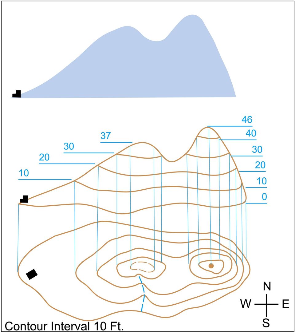
7 Mathematics in Orienteering compiled by Mike Minium, 2001 Measurement: Measure course length on map. (length on map in cm. or mm. then use scale to convert to m. or km.) feet. Measuring "climb" (the amount of uphill on course) Count number of contours crossed in an uphill direction. (If start/finish are at same place, this is total contours crossed divided by 2) Multiply number of contours by the contour interval to get climb in meters or English / Metric conversion of distances and climb. Percentage: Express climb percent of distance. Determine percentage of your time to complete course versus winning time. Time Computation: Find elapsed time. Subtract start time from finish time. Rate Computation: Compute average rate on course (usually expressed in minutes per kilometer) (remember to convert seconds to hundredths of minute) example: time of 35:24 = minutes. Statistics: Compute average times on course: mean, median, mode. Compare statistics: boys vs. girls. 2 (or more) different classes. 1st time doing a course vs. 2nd time doing same or similar course. Geometry: Measure angle (change of direction) at each control point. (angle less than 90 degrees is called a dog-leg. dog-legs are usually a flaw in course design). Compare real versus created dog-legs. Will competitors make a dog-leg even if straight line angle > 90 deg.

8 How many control points are the minimum needed to make a course: (that starts / finishes at same point)... with no angle greater than 90 degrees?... with no angle greater than 60 degrees? Add total angles of direction change for a whole course. If you treat left turns as negative and right turns as positive, you should end up with either 360 or why? (for a course that uses same point for both start and finish) If you treat all angles as positive, compare 2 or more courses. Which one has greater total changes of direction? Planar Geometry: What are contours? How do those lines translate to elevation? At what point would a competitor chose to go around a hill rather than over it? (One meter of climb is roughly equal to ten meters of horizontal.) Additionally, students can be familiarized with the use of symbols as abstract representations of real objects and states of being. There is nothing quite like running up a hill of changing steepness to familiarize the students with the concrete differences in angles in inclination. One demonstration of the meaning of the two dimensional representation of a three dimensional object is to cut up a potato (or other vegetable) into slices of uniform thickness and have the students trace the slices. This will result in a contour drawing of "Potato Mountain". These contours can then be used to calculate the volume of the potato. This same method can be applied to the map of the school grounds to calculate the amount of dirt that would have to be hauled away if the whole thing were to be razed for a soccer or baseball field.

9 BASIC ORIENTEERING INSTRUCTION = Distance, Direction & Details DETAILS - Map Familiarization A. Five colors: Each color represents a different class of features: Blue: Water (streams, marsh, pond) Green: Vegetation (dense woods, individual trees) Yellow: Clearings & fields Brown: Earth topography or contours (valleys, hills) Black: Natural objects (boulders, cliffs) Man-made features (trails, buildings) White: Normal forest B. Map Symbols: Use map legend and symbols to locate various features on the map. Can also relate surrounding features to symbols shown on the map. Orient the map A. Using the terrain: Turn the map until what is in front of you in the terrain is in front of you on the map B. Check using a compass: The north lines on the map should align with the compass needle. Thumbing A. Fold your map into a small easily held piece. Try to make the first fold on a N-S meridian. B. Place your thumb on the map near where you are. C. As you move along, move your thumb also to a new location on the map. D. This helps keep track of where you are. Map Walk: Read the map as you go along A. Point out features as you go along and identify on the map. B. Check map orientation as you go along. C. Check thumb position on the map D. Check what features you will be seeing next E. Contour reading: Compare terrain with map contours. Are you traveling uphill or downhill? Is it steep or level ground? Is there a rise on the left or right side? Orienteering techniques: C A R A. Control: Note the control description and symbol on the map. B. Attack Point: An easily found feature, such as a trail junction, trail bend, or stream crossing, that is near a control and is used to take a shorter more precise compass bearing to find a control. C. Route Choice: Which way should we go? Should we follow a trail or follow a compass

10 bearing? Which way is better or shorter? Does a longer trail route get to a better attack point? Is a trail faster than through woods and brush? Does it avoid steep climbs? DISTANCE - Pace Counting: Determine your pace (using a pace course). Then scale distances from the map and use your pace to locate controls. DIRECTION - Compass Bearings: 3 step method: A. Place the edge of the compass on the map so it goes from where you are to where you want to go. B. Holding the compass on the map, and ignoring the needle, turn the dial so the lines in the housing line up with the north-south lines on the map. C. Leaving the setting alone, turn yourself with the compass and map until the red end of the compass needle points to N on the dial (put RED in the SHED). The direction of travel arrow on the compass now points in the direction you want to go.

11

CONTENTS. Page 3 What is orienteering? Page 4 Activity: orienteering map bingo. Page 5 Activity: know your colours. Page 6 Choosing your compass
 THE RIGHT DIRECTION SCOUT ORIENTEER ACTIVITY BADGE CONTENTS Page What is orienteering? Page 4 Activity: orienteering map bingo Page 5 Activity: know your colours Page 6 Choosing your compass Page 7 Activity:
The Basics of Navigation
 The Basics of Navigation Knowledge of map reading and the use of the compass is an indispensable skill of bushcraft. Without this skill, a walker is a passenger and mere follower on a trip. To become a
NASA Explorer Schools Pre-Algebra Unit Lesson 2 Student Workbook. Solar System Math. Comparing Mass, Gravity, Composition, & Density
 National Aeronautics and Space Administration NASA Explorer Schools Pre-Algebra Unit Lesson 2 Student Workbook Solar System Math Comparing Mass, Gravity, Composition, & Density What interval of values
International Specification for Ski Orienteering Maps ISSkiOM
 International Specification for Ski Orienteering Maps ISSkiOM Rev 12 February 2015 corrected mistake (PMS 345-> PMS 354), page 3 2014 Approved by IOF Ski Orienteering Commission, October 2014 Approved
Watershed Delineation
 ooooo Appendix D: Watershed Delineation Department of Environmental Protection Stream Survey Manual 113 Appendix D: Watershed Delineation Imagine a watershed as an enormous bowl. As water falls onto the
Map reading made easy
 Map reading made easy What is a map? A map is simply a plan of the ground on paper. The plan is usually drawn as the land would be seen from directly above. A map will normally have the following features:
Map Patterns and Finding the Strike and Dip from a Mapped Outcrop of a Planar Surface
 Map Patterns and Finding the Strike and Dip from a Mapped Outcrop of a Planar Surface Topographic maps represent the complex curves of earth s surface with contour lines that represent the intersection
UKCC Level 1 Award in Coaching Orienteering Information Pack
 UKCC Level 1 Award in Coaching Orienteering Information Pack 1 of 15 British Orienteering 2 of 15 Index 1. Welcome 2. Foreword 3. Our Vision 4. What is UKCC? 5. Who are 1 st 4sport qualifications? 6. Coaching
How To Read Maps And Aerial Photos
 3 Read Maps and Aerial Photos WRITING SAMPLE (training guide) Stephen X. Arthur, technical writer 2005 www.transcanfilm.com/stephenarthur First draft. Copyright 1996, BC Ministry of Forests / BC Institute
Motion & The Global Positioning System (GPS)
") Grade Level: K - 8 Subject: Motion Prep Time: < 10 minutes Duration: 30 minutes Objective: To learn how to analyze GPS data in order to track an object and derive its velocity from positions and times.
Grade Level: K - 8 Subject: Motion Prep Time: < 10 minutes Duration: 30 minutes Objective: To learn how to analyze GPS data in order to track an object and derive its velocity from positions and times.
Plane Table. The Last. Surveyor? >> By Norman G. Sloan, PS, PE, MS
 The Last Plane Table Surveyor? ohn Sanford, 83, of Lakewood, Colorado, may be the Last, or almost last, plane table surveyor in the central U.S.A. John purchased his alidade and plane table for $70 in
MD5-26 Stacking Blocks Pages 115 116
 MD5-26 Stacking Blocks Pages 115 116 STANDARDS 5.MD.C.4 Goals Students will find the number of cubes in a rectangular stack and develop the formula length width height for the number of cubes in a stack.
SECTION 5 DRAFTING STANDARDS
 SECTION 5 DRAFTING STANDARDS 1 SECTION FIVE TABLE OF CONTENTS Description Page TABLE OF CONTENTS... 5-2 GENERAL... 5-3 DRAFTING STANDARDS... 5-5 DRAFTING MINIMUM REQUIREMENTS HANDOUT... 5-8 2 GENERAL 1.
Getting Started in Tinkercad
 Getting Started in Tinkercad By Bonnie Roskes, 3DVinci Tinkercad is a fun, easy to use, web-based 3D design application. You don t need any design experience - Tinkercad can be used by anyone. In fact,
2015 - Photography 4-H Project Newsletter
 2015 - Photography 4-H Project Newsletter Welcome to the 4-H Photography Project! This newsletter is your guide to the project. It contains rules, guidelines and suggestions. Read it carefully and keep
Appendix B: Course planning Table of contents
 Table of contents 1. Introduction... 4 1.1 Purpose... 4 1.2 Support... 4 2. General... 4 2.1 Formats... 4 2.2 Technical Difficulty... 5 2.3 Definitions of terms:... 6 2.4 Physical difficulty... 9 2.5 Planning
AwanaGames Circle. Official. Diagram 1. Key to diagram: Pin & Striped Bean Bag C Diagonal or Starting Line. B Scoring Pins, or Center.
 Official AwanaGames Circle Diagram 1 The AwanaGames Circle is 30 feet in diameter surrounded by a 37-40 foot square. Each team is designated by a color and occupies a quarter-circle or one side of that
Laser cutter setup instructions:
 Laser cutter setup instructions: 1. Cut your material to 18 x 24 or smaller. 2. Turn on the laser cutter by flipping the wall switch on the right behind Station B. You will hear the cooling fan and air
Hazlehead Course 2 Hole-By-Hole. Hole 1- Pinewood
 Hazlehead Course 2 Hole-By-Hole Hole 1- Pinewood You start your round looking uphill at the short 1st. A bunker to the left guards the green and trees to the right are a problem but a good sized playing
Basic Elements of Reading Plans
 Center for Land Use Education and Research at the University of Connecticut Basic Elements of Reading Plans University of Connecticut. The University of Connecticut supports all state and federal laws
Mille Bornes Rules. About the Theme
 Mille Bornes Rules Since 1962, MILLE BORNES has been nothing short of a sensation among card players in the United States. For a while, it even outsold the greatest game of them all, MONOPOLY. Now, Winning
Model Virginia Map Accuracy Standards Guideline
 Commonwealth of Virginia Model Virginia Map Accuracy Standards Guideline Virginia Information Technologies Agency (VITA) Publication Version Control Publication Version Control: It is the user's responsibility
Plotting Earthquake Epicenters an activity for seismic discovery
 Plotting Earthquake Epicenters an activity for seismic discovery Tammy K Bravo Anne M Ortiz Plotting Activity adapted from: Larry Braile and Sheryl Braile Department of Earth and Atmospheric Sciences Purdue
Get to Know Golf! John Dunigan
 Get to Know Golf! John Dunigan Get to Know Golf is an initiative designed to promote the understanding the laws that govern ball flight. This information will help golfers develop the most important skill
>> smart cross connect Users Guide. November 2014.
 >> smart cross connect Users Guide November 2014. >> Table of Contents 1 Overview 1.1 Getting Around 1.2 Pairing your smart with smart cross connect 2 In-Car Mode 2.1 Car Info 2.2 Navigation 2.2.1 Addresses
How do you compare numbers? On a number line, larger numbers are to the right and smaller numbers are to the left.
 The verbal answers to all of the following questions should be memorized before completion of pre-algebra. Answers that are not memorized will hinder your ability to succeed in algebra 1. Number Basics
Step by step guide to installing your own Ku Band satellite dish
 Step by step guide to installing your own Ku Band satellite dish If you don't feel comfortable installing your own system, your local TV Aerial or Handyman can easily follow these helpful guidelines for
Mathematics on the Soccer Field
 Mathematics on the Soccer Field Katie Purdy Abstract: This paper takes the everyday activity of soccer and uncovers the mathematics that can be used to help optimize goal scoring. The four situations that
SPM FIS B-Net Assembly Instructions. Installation Recommendations. 2009, World Cup Supply, Inc SPM B-Net Assembly/Installation
 SPM FIS B-Net Assembly Instructions & Installation Recommendations B-Net Assembly Instructions & Installation Recommendations TABLE OF CONTENTS 1. INTRODUCTION 3 2. GENERAL INFORMATION 4 3. SPM FIS B-NETS
SketchUp Instructions
 SketchUp Instructions Every architect needs to know how to use SketchUp! SketchUp is free from Google just Google it and download to your computer. You can do just about anything with it, but it is especially
White Mountain Guide Online User Guide
 White Mountain Guide Online User Guide 1.1 Minimum System Requirements page 2 1.2 Account Set-up page 2 2.0 Community Side Features page 4 2.1 View or Post a Trip Report page 4 2.2 View or Post a Trail
Converting Units of Measure Measurement
 Converting Units of Measure Measurement Outcome (lesson objective) Given a unit of measurement, students will be able to convert it to other units of measurement and will be able to use it to solve contextual
STATE OF ALASKA DEPARTMENT OF NATURAL RESOURCES DIVISION OF MINING, LAND AND WATER. GENERAL SURVEY INSTRUCTIONS EASEMENTS Authority 11 AAC 53
 STATE OF ALASKA DEPARTMENT OF NATURAL RESOURCES DIVISION OF MINING, LAND AND WATER GENERAL SURVEY INSTRUCTIONS EASEMENTS Authority 11 AAC 53 These instructions define the survey and platting criteria unique
Sweet Home 3D user's guide
 1 de 14 08/01/2013 13:08 Features Download Online Gallery Blog Documentation FAQ User's guide Video tutorial Developer's guides History Reviews Support 3D models Textures Translations Forum Report a bug
TECHNICAL GUIDELINES FOR ELITE TRAIL ORIENTEERING
 TECHNICAL GUIDELINES FOR ELITE TRAIL ORIENTEERING Timed control at WTOC 2004, Västerås, Sweden IOF Trail Orienteering Commission 2009 Summary The key to high quality of competition in elite international
Data Analysis, Statistics, and Probability
 Chapter 6 Data Analysis, Statistics, and Probability Content Strand Description Questions in this content strand assessed students skills in collecting, organizing, reading, representing, and interpreting
The Application of Land Use/ Land Cover (Clutter) Data to Wireless Communication System Design
 Data to Wireless Communication System Design") Technology White Paper The Application of Land Use/ Land Cover (Clutter) Data to Wireless Communication System Design The Power of Planning 1 Harry Anderson, Ted Hicks, Jody Kirtner EDX Wireless, LLC Eugene,
Technology White Paper The Application of Land Use/ Land Cover (Clutter) Data to Wireless Communication System Design The Power of Planning 1 Harry Anderson, Ted Hicks, Jody Kirtner EDX Wireless, LLC Eugene,
The crime scene sketch is an invaluable aid in recording
 Chapter 4 Crime Scene Sketch The crime scene sketch is an invaluable aid in recording investigative data. It is a permanent record that provides supplemental information that is not easily accomplished
Weekend Cabin Retreat Project Site Plans
 Weekend Cabin Retreat Project Site Plans Sacramento City College EDT 300/ENGR 306 EDT 300/ENGR 306 - Site Plans 1 Cabin Project Site Plan/Bubble Diagram - Assignment 1 =10-0 Floor Plan - Assignment 1/4
Where do they come from?
 Exploring Meteorite Mysteries Lesson 2 Follow the Falling Meteorite Objectives Students will: apply geometric properties and relationships to meteorite hunting. demonstrate and experience the way remote
LAYOUT OF THE LANDSCAPE PLAN ON PAPER
 LAYOUT OF THE LANDSCAPE PLAN ON PAPER The landscape drawing should always include a north arrow, a plant list and a legend. The legend will explain representations on the drawing (e.g. the way trees, walls,
Calculating Area and Volume of Ponds and Tanks
 SRAC Publication No. 103 Southern Regional Aquaculture Center August 1991 Calculating Area and Volume of Ponds and Tanks Michael P. Masser and John W. Jensen* Good fish farm managers must know the area
Ski on specific terrain (green, blue, black diamond, double black diamond) B Balancing Maintaining balance while in motion
 B Balancing Maintaining balance while in motion") Developing Skills A ski lesson should focus on a skier s skill development through the use of various encouraging tactics which include using exercises to help a student: Reinforce key movement Ski in
Developing Skills A ski lesson should focus on a skier s skill development through the use of various encouraging tactics which include using exercises to help a student: Reinforce key movement Ski in
Wind Direction Smart Sensor (S-WDA-M003)
") (S-WDA-M003) The Wind Direction smart sensor is designed to work with HOBO Stations. The smart sensor has a plug-in modular connector that allows it to be added easily to a HOBO Station. All sensor parameters
(S-WDA-M003) The Wind Direction smart sensor is designed to work with HOBO Stations. The smart sensor has a plug-in modular connector that allows it to be added easily to a HOBO Station. All sensor parameters
Suggested supplies include several sheets of white drawing paper, a few freshly sharpened pencils, a pencil sharpener, and tape.
 BLIND Brenda Hoddinott B-05 BEGINNER: LEARN TO SEE Learning to draw accurately depends on many hours of practicing the skill of coordinating your visual skills with your drawing hand, until your eyes and
BUILDING WITH STONE AND EARTH
 BUILDING WITH STONE AND EARTH PART 1 Earth is a popular building material all over the world. It can be used by itself, but if there is stone available, then the two can be used together to make very good
3D Drawing. Single Point Perspective with Diminishing Spaces
 3D Drawing Single Point Perspective with Diminishing Spaces The following document helps describe the basic process for generating a 3D representation of a simple 2D plan. For this exercise we will be
WHAT MAPS SHOW US Maps do 4 things:
 WHAT MAPS SHOW US Maps show us a range of features, for example: Landforms: Settlement: Communication: Land Use: Geology: Other Info: - hills - valleys - mountains - isolated dwellings - farms - villages
Warning! Construction Zone: Building Solids from Nets
 Brief Overview: Warning! Construction Zone: Building Solids from Nets In this unit the students will be examining and defining attributes of solids and their nets. The students will be expected to have
Imperial Length Measurements
 Unit I Measuring Length 1 Section 2.1 Imperial Length Measurements Goals Reading Fractions Reading Halves on a Measuring Tape Reading Quarters on a Measuring Tape Reading Eights on a Measuring Tape Reading
Experiment 3: Magnetic Fields of a Bar Magnet and Helmholtz Coil
 MASSACHUSETTS INSTITUTE OF TECHNOLOGY Department of Physics 8.02 Spring 2006 Experiment 3: Magnetic Fields of a Bar Magnet and Helmholtz Coil OBJECTIVES 1. To learn how to visualize magnetic field lines
Orienteering in Schools
 Orienteering in Schools 1 Introduction Orienteering is a challenging outdoor adventure sport that exercises both the mind and the body. The aim is to navigate in sequence between control points marked
Measuring with a Ruler
 Measuring with a Ruler Objective To guide children as they measure line segments to the nearest inch, _ inch, _ inch, centimeter, _ centimeter, and millimeter. www.everydaymathonline.com epresentations
Anamorphic Projection Photographic Techniques for setting up 3D Chalk Paintings
 Anamorphic Projection Photographic Techniques for setting up 3D Chalk Paintings By Wayne and Cheryl Renshaw. Although it is centuries old, the art of street painting has been going through a resurgence.
THLR WIND WIZ Instruction pdf (ver 1)
") +2 MIRAGE M/SEC = CROSSWIND GAP SHOOTING HIGHER/ OVER VISIBLE WIND ADD + CLICKS TO WIND CORRECTION THLR WIND WIZ Instruction pdf (ver ) THLR.NO VISUAL WIND M/SEC 2 3 Weak, occasional wind Weak, constant
+2 MIRAGE M/SEC = CROSSWIND GAP SHOOTING HIGHER/ OVER VISIBLE WIND ADD + CLICKS TO WIND CORRECTION THLR WIND WIZ Instruction pdf (ver ) THLR.NO VISUAL WIND M/SEC 2 3 Weak, occasional wind Weak, constant
STRAND: Number and Operations Algebra Geometry Measurement Data Analysis and Probability STANDARD:
 how August/September Demonstrate an understanding of the place-value structure of the base-ten number system by; (a) counting with understanding and recognizing how many in sets of objects up to 50, (b)
Activities and Ideas: Plants, Trees, and Seeds
 Mathematics Measurement: Take students outside to the playground with a list of plant and/or tree items they will find there (tree trunks, branches, leaves, seeds, flowers, etc.) and a measurement tool
Fun with Fractions: A Unit on Developing the Set Model: Unit Overview www.illuminations.nctm.org
 Fun with Fractions: A Unit on Developing the Set Model: Unit Overview www.illuminations.nctm.org Number of Lessons: 7 Grades: 3-5 Number & Operations In this unit plan, students explore relationships among
Topographic Survey. Topographic Survey. Topographic Survey. Topographic Survey. CIVL 1101 Surveying - Introduction to Topographic Modeling 1/8
 IVL 1 Surveying - Introduction to Topographic Modeling 1/8 Introduction Topography - defined as the shape or configuration or relief or three dimensional quality of a surface Topography maps are very useful
Math Board Games. For School or Home Education. by Teresa Evans. Copyright 2005 Teresa Evans. All rights reserved.
 Math Board Games For School or Home Education by Teresa Evans Copyright 2005 Teresa Evans. All rights reserved. Permission is given for the making of copies for use in the home or classroom of the purchaser
FUNDAMENTALS OF LANDSCAPE TECHNOLOGY GSD Harvard University Graduate School of Design Department of Landscape Architecture Fall 2006
 FUNDAMENTALS OF LANDSCAPE TECHNOLOGY GSD Harvard University Graduate School of Design Department of Landscape Architecture Fall 2006 6106/ M2 BASICS OF GRADING AND SURVEYING Laura Solano, Lecturer Name
Creating a History Day Exhibit Adapted from materials at the National History Day website
 Creating a History Day Exhibit Adapted from materials at the National History Day website Exhibits are designed to display visual and written information on topics in an attractive and understandable manner.
3D Drawing. Single Point Perspective with Diminishing Spaces
 3D Drawing Single Point Perspective with Diminishing Spaces The following document helps describe the basic process for generating a 3D representation of a simple 2D plan. For this exercise we will be
BEGINNING TERRAIN PARK SKI INSTRUCTION
 BEGINNING TERRAIN PARK SKI INSTRUCTION By Chuck Roberts PSIA Certified Level III Alpine http://www.robertsski.com [email protected] - 1 - Copyright 2004 Charles C. Roberts, Jr. All rights reserved. Printed
1 laser altimeter. Background & Instructions. exploration extension. Instructions. Background
 extension 1 laser altimeter Background & First 3-D view of the north pole of Mars from MOLA (Image credit: MOLA science Team/NASA/GSFC SVS) Background A laser altimeter is a device used aboard planet-orbiting
Bicycle Safety Quiz Answers Parental Responsibilities
 Bicycle riding is a great way to get into shape and enjoy the outdoors. To remain safe on Illinois roads, it is important to follow the same traffic safety laws that govern vehicle drivers. No amount of
The Basics of Robot Mazes Teacher Notes
 The Basics of Robot Mazes Teacher Notes Why do robots solve Mazes? A maze is a simple environment with simple rules. Solving it is a task that beginners can do successfully while learning the essentials
BACKPACKING TRIP DIFFICULTY SNAPSHOT
 BACKPACKING TRIP DIFFICULTY SNAPSHOT Of course these ratings are only an indicator of hike difficulty - every hike has its variables beyond elevation gain and distance including weather, experience/fitness,
Subject: Math Grade Level: 5 Topic: The Metric System Time Allotment: 45 minutes Teaching Date: Day 1
 Subject: Math Grade Level: 5 Topic: The Metric System Time Allotment: 45 minutes Teaching Date: Day 1 I. (A) Goal(s): For student to gain conceptual understanding of the metric system and how to convert
Atomic Force Microscope and Magnetic Force Microscope Background Information
 Atomic Force Microscope and Magnetic Force Microscope Background Information Lego Building Instructions There are several places to find the building instructions for building the Lego models of atomic
TUTORIAL MOVE 2009.1: 3D MODEL CONSTRUCTION FROM SURFACE GEOLOGICAL DATA
 UNIVERSITÁ DEGLI STUDI DI MILANO FACOLTÀ DI SCIENZE MATEMATICHE FISICHE E NATURALI DIPARTIMENTO DI SCIENZE DELLA TERRA ARDITO DESIO TUTORIAL MOVE 2009.1: 3D MODEL CONSTRUCTION FROM SURFACE GEOLOGICAL DATA
Kristen Kachurek. Circumference, Perimeter, and Area Grades 7-10 5 Day lesson plan. Technology and Manipulatives used:
 Kristen Kachurek Circumference, Perimeter, and Area Grades 7-10 5 Day lesson plan Technology and Manipulatives used: TI-83 Plus calculator Area Form application (for TI-83 Plus calculator) Login application
Solving Geometric Applications
 1.8 Solving Geometric Applications 1.8 OBJECTIVES 1. Find a perimeter 2. Solve applications that involve perimeter 3. Find the area of a rectangular figure 4. Apply area formulas 5. Apply volume formulas
Lesson 26: Reflection & Mirror Diagrams
 Lesson 26: Reflection & Mirror Diagrams The Law of Reflection There is nothing really mysterious about reflection, but some people try to make it more difficult than it really is. All EMR will reflect
HONEY, I SHRUNK THE SOLAR SYSTEM
 OVERVIEW HONEY, I SHRUNK THE SOLAR SYSTEM MODIFIED VERSION OF A SOLAR SYSTEM SCALE MODEL ACTIVITY FROM UNDERSTANDING SCIENCE LESSONS Students will construct a scale model of the solar system using a fitness
Math vocabulary can be taught with what Montessorians call the Three Period Lesson.
 Full Transcript of: Montessori Mathematics Materials Presentations Introduction to Montessori Math Demonstrations ( Disclaimer) This program is intended to give the viewers a general understanding of the
6 LED colours: White Blue Green Red Yellow Amber
 Illuminated contours can be found in many places on petrol stations and buildings of industrial, commercial and service companies. Such light bands visually emphasize the contours of a building during
Numeracy Targets. I can count at least 20 objects
 Targets 1c I can read numbers up to 10 I can count up to 10 objects I can say the number names in order up to 20 I can write at least 4 numbers up to 10. When someone gives me a small number of objects
Colour by Numbers Image Representation
 Activity 2 Colour by Numbers Image Representation Summary Computers store drawings, photographs and other pictures using only numbers. The following activity demonstrates how they can do this. Curriculum
Little Blue and Little Yellow: A Story for Pippo and Other Children. Little Blue and Little Yellow: Predicting the Story Critical Thinking
 Little Blue and Little Yellow: A Story for Pippo and Other Children (ASTOR-HONOR, 1959) This Book s Message or Theme - - Friends come in all colors. Friends can affect each other s lives. About the Book
Technical Drawing Specifications Resource A guide to support VCE Visual Communication Design study design 2013-17
 A guide to support VCE Visual Communication Design study design 2013-17 1 Contents INTRODUCTION The Australian Standards (AS) Key knowledge and skills THREE-DIMENSIONAL DRAWING PARALINE DRAWING Isometric
Performance Based Learning and Assessment Task
 Performance Based Learning and Assessment Task Activity/Task Title I. ASSESSSMENT TASK OVERVIEW & PURPOSE: Students will be asked to find various characteristics of a polynomial function, modeled by a
delorme.com/earthmate Earthmate A Guide to the Complete GPS Navigation Solution for Smartphones and Tablets.
 delorme.com/earthmate Earthmate A Guide to the Complete GPS Navigation Solution for Smartphones and Tablets. EARTHMATE I N C L U D E D A guide to Earthmate Hunt Edition is included in this document. Earthmate
Unit 1: Family Letter
 Name Date Time HOME LINK Unit 1: Family Letter Introduction to Third Grade Everyday Mathematics Welcome to Third Grade Everyday Mathematics. It is part of an elementary school mathematics curriculum developed
In Association With. Introduces. TPT Contractor
 In Association With Introduces TPT Contractor Software for Contractors with TENSIONMETERS Table of Contents Capabilities 4 Setup and Use 7 The Dashboard 12 Tower Setup Form 18 Measurement or Inspection
To start using your phone as a navigation device, tap the TomTom button in the Windows Mobile start menu.
 TomTom NAVIGATOR 1. Before you start... Before you start... Setting up To start using your phone as a navigation device, tap the TomTom button in the Windows Mobile start menu. To set up your navigation
LIGHT SECTION 6-REFRACTION-BENDING LIGHT From Hands on Science by Linda Poore, 2003.
 LIGHT SECTION 6-REFRACTION-BENDING LIGHT From Hands on Science by Linda Poore, 2003. STANDARDS: Students know an object is seen when light traveling from an object enters our eye. Students will differentiate
Benton MacKaye Trail - Section 2. Three Forks (FS 58) to GA. Highway 60. 11.4 miles
 to GA. Highway 60. 11.4 miles") General Benton MacKaye Trail - Section 2 Three Forks (FS 58) to GA. Highway 60 11.4 miles This is the longest and most remote section of the Benton MacKaye Trail (BMT) east of GA 5. It follows the Appalachian
General Benton MacKaye Trail - Section 2 Three Forks (FS 58) to GA. Highway 60 11.4 miles This is the longest and most remote section of the Benton MacKaye Trail (BMT) east of GA 5. It follows the Appalachian
CARD CUTTER MACHINE STUDENT.MANUAL
 CARD CUTTER MACHINE STUDENT.MANUAL Digital Fabrication Laboratory Hours 10am - 3pm (Monday-Friday) Email [email protected] Contact 9035 8663 105A, First Floor, 757 Swanston st Faculty of Architecture
How to erect a Kelty Grand Mesa 4 tent
 How to erect a Kelty Grand Mesa 4 tent Introduction When selecting a tent, one must first choose what purpose the tent will serve. There are many types of tents which serve a variety of purposes. These
CHAPTER 4 DIMENSIONAL ANALYSIS
 CHAPTER 4 DIMENSIONAL ANALYSIS 1. DIMENSIONAL ANALYSIS Dimensional analysis, which is also known as the factor label method or unit conversion method, is an extremely important tool in the field of chemistry.
Homework Activities for Kindergarten
 Homework Activities for Kindergarten Listed below are several learning activities for your child to complete at home to reinforce skills being taught in school. The sight words are on the last page. Reading
Tools for Teachers t e a c h i n g c U r r i c u l u m f o r h o m e a n d t h e c l a s s r o o m
 Tools for Teachers t e a c h i n g c U r r i c u l u m f o r h o m e a n d t h e c l a s s r o o m One One You Adri s mama and papa share some of the wisdom they have gained through the years with their
PAYCHEX, INC. BASIC BUSINESS MATH TRAINING MODULE
 PAYCHEX, INC. BASIC BUSINESS MATH TRAINING MODULE 1 Property of Paychex, Inc. Basic Business Math Table of Contents Overview...3 Objectives...3 Calculator...4 Basic Calculations...6 Order of Operation...9
Examples of Data Representation using Tables, Graphs and Charts
 Examples of Data Representation using Tables, Graphs and Charts This document discusses how to properly display numerical data. It discusses the differences between tables and graphs and it discusses various