Georeferencing and Google Earth. Cyberinfrastructure: Specimen Databases: Day 5 Brigette Zacharczenko
|
|
|
- Walter Day
- 10 years ago
- Views:
Transcription
1 Georeferencing and Google Earth Cyberinfrastructure: Specimen Databases: Day 5 Brigette Zacharczenko 1

2 Georeferencing standards Georeferencing of legacy data Georeferencing exercise Mapping data Using Google Earth Importing data into ArcGIS Google Earth exercises 2

3 Georeferencing Introduction Collecting Data The Georeferencing Process Legacy Data Data Quality Guidelines 3

4 Introduction Georeference = to translate a locality description into a mappable representation of a feature 4

5 Where to get data? Your own research Online Collection databases Local/state websites USGS National Geo-spatial Intelligence Agency Gazetteers Maps TopoZone 5


6 Collecting Data Detailed locality descriptions Even if you do have coordinates! Importance of redundancy Think about stable vs. unstable localities Could that boulder be moved? Could that big tree be cut down? Will that old barn still be there in 50 years? Direction, distance 6

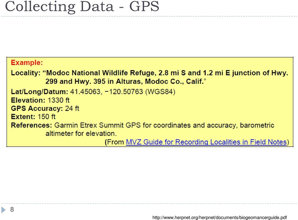
7 Collecting Data with a GPS Using a GPS unit Need an open area, and should detect at least four satellites What to record Coordinates The datum (usually WGS84) Accuracy Make of GPS receiver Year, elevation, extent Be aware of True vs. Magnetic North 7


8 Collecting Data - GPS 8
9 The Georeferencing Process Creating a database Decide which fields you need What is useful to your research question Think about DarwinCore standards Put constraints on fields to reduce errors Standards and guidelines Units, methods for determining uncertainty and extent Required fields, format of coordinates, decimal places How to deal with null values What data validation is required before a record can be considered complete? 9

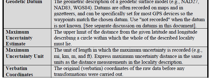
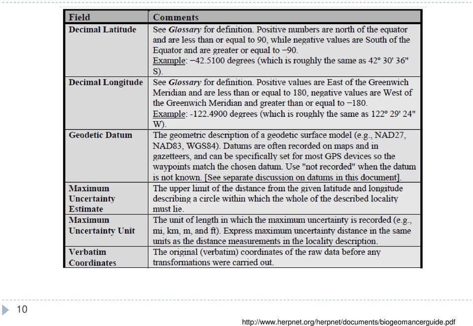
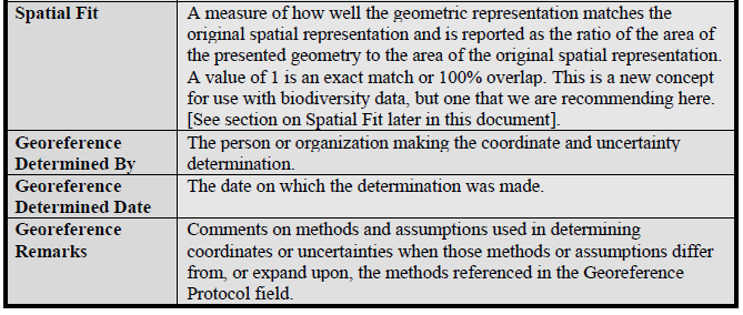
10 10
11 11

12 Legacy Data What to do about backlog of specimen records in museums and collections? 12

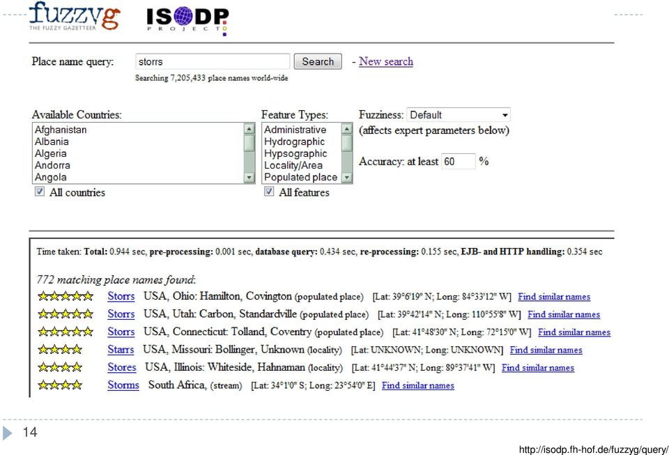
13 Legacy Data Classifying locality descriptions The most specific part of the locality description should be used for georeferencing Determining coordinates and extents Gazetteers A gazetteer is a geographical dictionary or directory, an important reference for information about places and place names, used in conjunction with a map or a full atlas Fuzzy Gazetteer Can handle variations in spelling, great for old labels Fuzzy Gazetteer US Census Gazetteer USGS Gazetteer 13


14 14
15 Determining Coordinates and Extents Finding the extent Every named place occupies a finite space, or extent. The extent is usually measured as the distance from the geographic center of the shape that defines the feature, to the furthest extremity of that shape. Irregular shape, two choices: Measure along the vector and determine the mid-point as the location Determine geographic center (midpoint of extremes of lat and long), extent is the distance from that position to the furthest point. If the geographic center does not lie on the locality exactly (like a river), choose the closest point 15

16 Determining Coordinates and Extents Extents area vs. linear Differentiating between an entire path you traveled, vs. measuring from the center to the perimeter of an areal extent Be consistent measure from the midpoint to the farthest point Area could also be calculated for an irregular shape in a mapping program such as ArcMap 16

 17 http://www.herpnet.")
17 Calculating Uncertainties Valuable to determine data quality Unknown datum There can be differences from a few cm to several km Distance Several methods (by fraction, powers of 10) 17
 17 http://www.herpnet.")

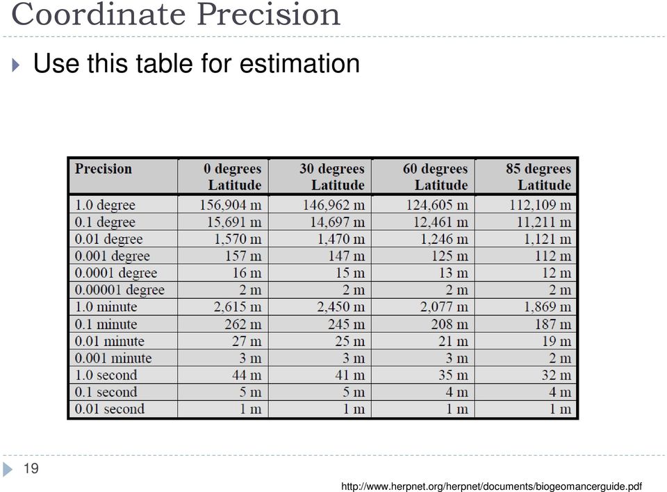
18 Coordinate Precision uncertainty=sqrt( lat_error 2 + long_error 2 ) lat_error = pi*r*lat_long_precision/180.0 long_error = pi*x*lat_long_precision/180.0 R is the radius of curvature of the meridian at the given latitude, X is the distance from the point to the polar axis orthogonal to the polar axis lat_long_precision is the precision with which the coordinates were recorded, as a fraction of one degree. 18


19 Coordinate Precision Use this table for estimation 19
20 Maintaining Data Quality Feedback to collectors ensure consistency Feedback from users have a system for handling, verifying, and recording user feedback Data checking Data entry New trainee check first batch of records, and regular random checks after that Data validation Check against your database, other databases, gazetteers Use statistical methods or modeling to determine outliers 20

21 Maintaining Data Quality Always add, never replace or delete! Have extra fields to make changes Remarks fields Record who made the changes (Could depend on the type of change fixing spelling vs. a new name) 21
22 Maintaining Data Quality 1. Completeness Index percentage of records with georeference fields that have values percentage of records with extent fields that have values percentage of records with uncertainty fields that have values percentage of records with coordinate-precision fields with a value percentage of records with datum fields that have a known datum value 2. Uncertainty Index average and standard deviation of uncertainty value for those records that have a value percentage of records with a maximum uncertainty value in each class a. <100 m b ,000 m c. 1,000-2,000 m d. 2,000-5,000 m e. 5,000-10,000 m f. >10,000 m g. not determined 3. Currency Index time since last data entry time since last validation check 4. Validation Index percentage of records that have undergone validation test x percentage of records that have undergone validation test y, etc. percentage of records identified as suspect using validation tests percentage of suspect records found to be actual errors 22
23 Guidelines As put together by BioGeoMancer guide.pdf Darwincore 23
24 EXAMPLE 1 PENNA, Indiana Co. 3 mi NE of Elderton 24 Brigette Zacharczenko
25 EXAMPLE 1 What does PENNA mean? Check for unusual state abbreviations. Next we will look for Elderton
26 EXAMPLE 1 So now we have: Lat: 40 41'42'' N; Long: 79 20'30'' W How to check that this is the right place, and to find the location 3 miles NE of the town? Let's look in Google Maps 26
27 EXAMPLE 1 We landed in the town of Elderton in Pennsylvania, looks good! The coordinates are usually given as the center of the town. 27
28 EXAMPLE 1 Now what about the actual collection locality? Open Google Earth, and search by the coordinates. Using the Ruler tool, draw a path 3 miles to the NE of the town. Save the line, zoom in to the end, add a point, and collect the coordinates. 28
29 EXAMPLE 1 Now we have , But we cannot really know if that is quite where the specimen was collected. Being 3 miles northeast of the town could be a very rough estimate. So how should we treat the coordinates? 29
30 EXAMPLE 1 By reducing the accuracy (the number of decimal points) we can cover a wider area with our uncertainty, hopefully including the collection locality. Let's say we want to include an area of about 100m in any direction. Accuracy changes with latitude, so we would have an uncertainty of about 140 m. Alternatively, we could keep the exact coordinates, and have a separate column for uncertainty. In this case, extent would not be meaningful. 30
31 EXAMPLE 1 So now we have: Country: USA State: Pennsylvania County: Indiana Co. Location: 3 mi NE of Elderton Coordinates: , This information can be added to your database (do not worry about having separate columns for the later exercise, you can replace your data) 31
32 EXAMPLE 2 Now let s try one from Turkey! TURKEY, Kirklareli Prov., Dereköy, elev. 600m 32 Brigette Zacharczenko

33 EXAMPLE 2 Way too many results what now? 33
34 EXAMPLE
35 EXAMPLE 2 So now we have: Country: TURKEY Province: Kirklareli Town: Dereköy Coordinates: 41.93,
36 GEOREFERENCING EXERCISE Your specimens have varying levels of locality information on their labels. Use any available resources to find the latitude and longitude for each location, and fill in any other missing locality data. If a lat/long are provided, double check the accuracy. Choose 6 specimens for this exercise Each specimen label is like its own little detective story, there is no one correct way to verify a location. The accuracy will depend on how much information is available to you and how much you are able to interpret. When you are done add this information to your database, and it to Brigette. 36
37 Helpful Resources: Google Earth viations
38 Visualizing Specimen Data Many programs available, depending on your needs Do you just want to see a distribution of points, or do more in depth analysis? Do you want to have specimen data appended to the points? Google Earth, Google Maps, ArcMap, Berkeley Mapper, R, Discover Life 38
39 Applications Biogeography Species richness Species characteristics such as age class, prey/host, niche, body size, guild, clutch size, etc. Patterns through time such as climate change, the spread of invasive species and diseases, the impact of human activities Examples: 39
40 Google Earth Visualize your data collection Keep a log of your collection points, notes, and photos in one interactive file Share your data with others Coordinate data between Google Earth and other programs 40
41 Getting Started Importing data into Google Earth Directly from a GPS Manually, one point at a time Import a spreadsheet Import from ArcMap 41
42 GPS to Google Earth Garmin, Magellan, Wintec WBT-201 More details about supported devices here 42

43 GPS to Google Earth Directly from GPS, or from a file created by your GPS on your computer 43
44 Manually Adding Data Points Would be tedious for an already established database Fine for a few points, or if you want to visualize your progress during a trip as you go along 44
45 Quick and Easy Example Don t have time to play around with codes or making it look fancy drop some points and photos 45
46 Quick and Easy Example 46
47 Quick and Easy Example If you want to customize the pop-up information for a point, you can add code to the description to include photos, links, etc. 47
48 Tools You can create: Points, polygons, paths, image overlays, photos, tours Paths will follow contours A tour will record your mouse clicks if you click on points, images, travel to a new area, etc. You can measure: Straight lines, paths 48
49 Importing from a Spreadsheet Google docs Spreadsheet Mapper v2.0 Click here for tutorial ml To get started: starter spreadsheet ziwunnsngkqq_v-spusrq&newcopy Can handle up to 400 placemarks Spreadsheet Mapper has templates to visualize your information in Google Earth, you can edit them or create your own 49

50 Spreadsheet Mapper v
51 Spreadsheet to Google Earth 51
52 52
53 Importing from a Database Can be tricky, depending on the database! Some have direct links to show points in Google Earth If you can obtain an Excel file of data, you can use Google Fusion to create a KML file Unlike the Spreadsheet Mapper, Google Fusion can handle over 400 placemarks 53
54 Collecting data from HerpNET 54
55 Collecting data from HerpNET Open the file in Notepad Save as a.txt file New file in Excel > Data tab > From file > Choose your.txt file Data clean-up: You MUST remove all records missing coordinates. The data table will not omit them, it will instead create a map based on the country or state. Change the decimallatitude to Latitude and decimallongitude to Longitude 55
56 Google Fusion Tables New table > Import table > Choose your Excel file You can edit the table here 56
57 Google Fusion to Google Earth Visualize > Map > Export to KML > Save file 57
58 It s like magic! Google Earth File > Open 58
59 Sharing To save a folder Make sure the folder you want to save is highlighted File > Save > Save place as > Save as.kmz To double check, you can try opening the file in Google Earth 59
60 Sharing To save a snapshot image of exactly what is on your screen File > Save > Save image > Save as.jpg To share your file Simply them the file you have saved! Sharing with the Google Earth Community You need to be a member 60
61 Google Earth Layers Regular users have access to: Panoramio (user images), Roads, Weather, Terrain, Street View, Ground Level View, 3D trees (version 6 and later) Pro users have access to: Demographics, Parcel Boundaries, Traffic Count 61
62 Google Earth Pro Increase employee productivity, communicate visually, and share geographic information with Google Earth Pro. With the same easy-to-use features and imagery of Google Earth and additional capabilities designed specifically for business users, Google Earth Pro offers the most comprehensive geospatial database, including seamless cityscapes, high-resolution imagery, historical imagery, roads, and points of interest. Expand your business, explore untapped markets and understand your target demographic using Google Earth Pro Datasets. View parcel, demographic, and daily traffic count data for the US overlaid on top of the same, familiar imagery of Google Earth. 62
63 Google Earth Pro 63
64 Google Earth Enterprise Google Earth Enterprise allows you to create 2D browser based maps similar to Google Maps in addition to custom globes similar to Google Earth. Mashup terabytes of imagery and terrain data with to your POI, road data and live data streams. Let novices feel like GIS experts with accessible GIS data. Useful for very large datasets 64
65 The Future of Google Earth What s on the horizon? Adding more GIS layers? More high res images? More tools for biologists? 65

66 66

67 67
68 68
69 To Learn More: Google Earth Home 69
70 Google Earth and GIS Since Google Earth does not currently have all the tools a biologist needs, it can be used in conjunction with ArcGIS If your data starts in ArcMap You might want to share your results in an intuitive way to non-scientists You might want to share your results with other scientists without divulging your original files If your data starts in Google Earth You might want to investigate ecological questions by overlaying parameters such as soil type, vegetation, human habitation, precipitation, monthly temperatures, other species ranges, etc. 70
71 Google Earth and GIS Data exploration You never know what will inspire you to ask new questions Visualizing your data in Google Earth could reveal new features not available in old shapefiles (new roads, forests that have been cut, sea levels changing) Keep in mind Google Earth uses the datum WGS84 71
72 Google Earth to ArcMap You need to download a new toolbox: Convert KML to SHP Save your Google Earth file as.kml Use the toolbox to create a shapefile 72
73 Google Earth to ArcMap 73

74 ArcMap to Google Earth Conversion Tools > To KML > Layer to KML Open the resulting file in Google Earth 74
75 GOOGLE EARTH EXERCISE 1 Use Google Spreadsheet Mapper v2.0 to map your specimen data in Google Earth Make sure your Excel file only includes records with coordinates Follow this Tutorial Choose at least one specimen to include a photo and full collection data For adding Flickr images: Go to image page, right click, choose View All Sizes: Medium 500. Right click, choose Copy Image Location Save the Google Earth file and it to Brigette 75

76 Troubleshooting Be sure you follow the tutorial instructions carefully Sometimes there are issues copying and pasting within the spreadsheet be patient, but persistent! The template number should be used in the first header row, as well as the data rows The information in each column should match the header label, based on the template number When copying the network link to Google Earth click on the cell, use ctrl+c, then right click My Places in Google Earth, there should be an option to Paste If you cannot get the spreadsheet to connect to Google Earth, try the link to see it in Google Maps. You can still look at your data points and photos this way. 76
77 GOOGLE EARTH EXERCISE 2 Collect specimen records from HerpNET and map them in Google Earth using Google Fusion Tables Choose any species, gather as many records from as many institutions as you would like In Excel, create a file that only has records with coordinates Open the file in Google Fusion, and create a KML file Open the KML file in Google Earth Follow the step-by-step instructions as given in the example on slides Save the Google Earth file and it to Brigette 77
Using Google Earth for Environmental Science Research
 Using Google Earth for Environmental Science Research This document is up-to-date as of August 2013. If you have any questions or additions to this material please email [email protected]. Note: this
Introduction to GIS software
 Introduction to GIS software There are a wide variety of GIS software packages available. Some of these software packages are freely available for you to download and could be used in your classroom. ArcGIS
What is GIS? Geographic Information Systems. Introduction to ArcGIS. GIS Maps Contain Layers. What Can You Do With GIS? Layers Can Contain Features
 What is GIS? Geographic Information Systems Introduction to ArcGIS A database system in which the organizing principle is explicitly SPATIAL For CPSC 178 Visualization: Data, Pixels, and Ideas. What Can
Introduction to GIS (Basics, Data, Analysis) & Case Studies. 13 th May 2004. Content. What is GIS?
 & Case Studies. 13 th May 2004. Content. What is GIS?") Introduction to GIS (Basics, Data, Analysis) & Case Studies 13 th May 2004 Content Introduction to GIS Data concepts Data input Analysis Applications selected examples What is GIS? Geographic Information
Introduction to GIS (Basics, Data, Analysis) & Case Studies 13 th May 2004 Content Introduction to GIS Data concepts Data input Analysis Applications selected examples What is GIS? Geographic Information
Google Earth Digitale Wege in eine bekannte Welt Sep. 2006
 Google Earth Digitale Wege in eine bekannte Welt Sep. 2006 Joachim Glaubrecht Google Enterprise [email protected] What is Google Enterprise? 2 1 Focus.de: "Der Papst-Besuch in Google Earth" 3 How to Geo
TUTORIAL - Locations & Mapping. Using the ESdat Environmental Database System. For use with ESDAT version 5
 TUTORIAL - Locations & Mapping Using the ESdat Environmental Database System For use with ESDAT version 5 (version 5 software updates available from ) Function Tutorial - Locations and Mapping Table of
Quick and Easy Web Maps with Google Fusion Tables. SCO Technical Paper
 Quick and Easy Web Maps with Google Fusion Tables SCO Technical Paper Version History Version Date Notes Author/Contact 1.0 July, 2011 Initial document created. Howard Veregin 1.1 Dec., 2011 Updated to
Guide to Viewing Maps in Google Earth
 Guide to Viewing Maps in Google Earth The BCT made the decision to provide the GIS (Geographic Information System) resources for Bat Groups in the form of Google Earth maps because they do not require
Chapter 6: Data Acquisition Methods, Procedures, and Issues
 Chapter 6: Data Acquisition Methods, Procedures, and Issues In this Exercise: Data Acquisition Downloading Geographic Data Accessing Data Via Web Map Service Using Data from a Text File or Spreadsheet
A GIS helps you answer questions and solve problems by looking at your data in a way that is quickly understood and easily shared.
 A Geographic Information System (GIS) integrates hardware, software, and data for capturing, managing, analyzing, and displaying all forms of geographically referenced information. GIS allows us to view,
Making MAGIC with Your Data: Interactive Maps, Map Mashups, and Data Visualization Tools
 Making MAGIC with Your Data: Interactive Maps, Map Mashups, and Data Visualization Tools Michael Howser Connecticut State Data Center Coordinator & Undergraduate Education & GIS Librarian What is the Connecticut
Mapping Your Land: An Overview for Landowners
 Mapping Your Land: An Overview for Landowners Online Mapping and Spatial Resources for the Private Forest Landowner Tutorials by John C. Gilbert 1 and John S. Kush 1 Design and Layout by Elizabeth P. Bowersock
From GPS Data Collection to GIS Data Display A Walk-Through Example
 From GPS Data Collection to GIS Data Display A Walk-Through Example The Global Positioning System (GPS) is a satellite based navigation system consisting of 24 satellites, a worldwide network of tracking
Introduction to Google Earth
 Center for Teaching, Research & Learning Social Science Research Lab American University, Washington, D.C. http://www.american.edu/provost/ctrl/ 202-885-3862 Introduction to Google Earth This tutorial
GEOGRAPHIC INFORMATION SYSTEMS Lecture 20: Adding and Creating Data
 Adding Existing Data Into ArcGIS - there are many different ways to get data into ArcGIS GEOGRAPHIC INFORMATION SYSTEMS Lecture 20: Adding and Creating Data Add Data - normally we use the Add Data button
How to georectify an image in ArcMap 10
 How to georectify an image in ArcMap 10 The University Library has a large collection of historical aerial photos for some North Carolina Counties ( http://www.lib.unc.edu/reference/gis/usda/index.html
How to Download Census Data from American Factfinder and Display it in ArcMap
 How to Download Census Data from American Factfinder and Display it in ArcMap Factfinder provides census and ACS (American Community Survey) data that can be downloaded in a tabular format and joined with
ArcGIS online Introduction... 2. Module 1: How to create a basic map on ArcGIS online... 3. Creating a public account with ArcGIS online...
 Table of Contents ArcGIS online Introduction... 2 Module 1: How to create a basic map on ArcGIS online... 3 Creating a public account with ArcGIS online... 3 Opening a Map, Adding a Basemap and then Saving
Studying Topography, Orographic Rainfall, and Ecosystems (STORE)
") Studying Topography, Orographic Rainfall, and Ecosystems (STORE) Introduction Basic Lesson 2: Using ArcGIS Explorer to Analyze the Connection between Topography and Rainfall This lesson introduces Geographical
Studying Topography, Orographic Rainfall, and Ecosystems (STORE) Introduction Basic Lesson 2: Using ArcGIS Explorer to Analyze the Connection between Topography and Rainfall This lesson introduces Geographical
Introduction to Google Earth May 24, 2011. TJ Keiran Senior Planner / GIS Specialist Cowlitz-Wahkiakum Council of Governments
 Introduction to Google Earth May 24, 2011 TJ Keiran Senior Planner / GIS Specialist Cowlitz-Wahkiakum Council of Governments Purpose of this class Introduce free version of Google Earth Demonstrate common
Google Earth for Surveyors PLSO Conference January 21, 2015. Bill Clark Earth Point
 Google Earth for Surveyors PLSO Conference January 21, 2015 Bill Clark Earth Point Introduction Bill Clark, developer of Earth Point www.earthpoint.us [email protected] 208.860.6311 Notes These
What is GIS. What is GIS? University of Tsukuba. What do you image of GIS? Copyright(C) ESRI Japan Corporation. All rights reserved.
 ESRI Japan Corporation. All rights reserved.") What is GIS University of Tsukuba Graduate School of Life and Environmental Science April 21 st, 2011 What is GIS? What do you image of GIS? Gas Insulated Switch Groupe Interventional Speciale Geographic
What is GIS University of Tsukuba Graduate School of Life and Environmental Science April 21 st, 2011 What is GIS? What do you image of GIS? Gas Insulated Switch Groupe Interventional Speciale Geographic
Quick Start Guide to. ArcGISSM. Online
 Quick Start Guide to ArcGISSM Online ArcGIS Online Quick Start Guide ArcGIS SM Online is a cloud-based mapping platform for organizations. Users get access to dynamic, authoritative content to create,
Creating a File Geodatabase
 Creating a File Geodatabase Updated by Thomas Stieve January 06, 2012 This exercise demonstrates how to create a file geodatabase in ArcGIS 10; how to import existing data into the geodatabase, and how
Reef Explorer User Guide
 Reef Explorer User Guide Contents USER INTERFACE...2 DATA CONTENT...3 BASEMAPS...4 ESRI BASEMAPS...4 National Geographic World Map...4 Light Gray Canvas Map...4 Ocean Basemap...4 World Terrain Base...4
Contents. The OWRB Floodplain Viewer. Creating Maps... 8. Helpful Tips... 10
 Contents QUICK START GUIDE... 2-5 Add layers...9 Search for Layers...9 COMPREHENSIVE GUIDE... 6 Navigate the map...6 Locate specific places...6 Add layer from file...9 Add layer from web...9 Display pop-up
Texas Wildfire Risk Assessment Portal (TxWRAP) User Manual. Texas A&M Forest Service
 User Manual. Texas A&M Forest Service") Texas Wildfire Risk Assessment Portal (TxWRAP) User Manual Texas A&M Forest Service October 2012 Table of Contents 1 ABOUT TXWRAP... 7 1.1 ACCESSING TXWRAP... 7 1.2 GETTING SUPPORT... 8 Documentation...
Texas Wildfire Risk Assessment Portal (TxWRAP) User Manual Texas A&M Forest Service October 2012 Table of Contents 1 ABOUT TXWRAP... 7 1.1 ACCESSING TXWRAP... 7 1.2 GETTING SUPPORT... 8 Documentation...
Practical, Easy-to-Use, Free GIS and Remote Sensing Tools for Resource Management
 Practical, Easy-to-Use, Free GIS and Remote Sensing Tools for Resource Management Andrew Lister Research Forester 11 Campus Blvd, Ste. 200 Newtown Square, PA 19073 [email protected] Abstract: Geographic
2. Look for a link to ODESI data portal. In the Key Links section in the left side and double click ODESI Data Retrieval.
 Guide to convert census data from ODESI into GIS data ODESI, acronym for Ontario Data Documentation, Extraction Service and Infrastructure, is a web-based data exploration, extraction and analysis tool
Objectives. Raster Data Discrete Classes. Spatial Information in Natural Resources FANR 3800. Review the raster data model
 Spatial Information in Natural Resources FANR 3800 Raster Analysis Objectives Review the raster data model Understand how raster analysis fundamentally differs from vector analysis Become familiar with
Conservation Workshop ArcGIS Explorer
 Conservation Workshop ArcGIS Explorer Bern Szukalski [email protected] Topics for this session Introduction Overview of features Using ArcGIS Explorer effectively New features & capabilities Customization
Raster to Vector Conversion for Overlay Analysis
 Raster to Vector Conversion for Overlay Analysis In some cases, it may be necessary to perform vector-based analyses on a raster data set, or vice versa. The types of analyses that can be performed on
Converting GIS Datasets into CAD Format
 Ball State University Libraries GIS Research and Map Collection Converting GIS Datasets into CAD Format Author: Angela Gibson, 6/13/2014 Overview: One of the most common requests from students is for GIS
Software: AutoCAD Civil 3D 2014, NRCS C3D 2014 template, ESRI ArcMap. Notation:Button to Press Displayed Text Icon Action {Text to Enter} Menu Item
 Overview: Use the following processes for exchanging georeferenced data between AutoCAD Civil 3D 2014 and ArcMap. The work must be based in any real world coordinate system. (This example uses NAD 83 UTM
Finding GIS Data and Preparing it for Use
 Finding_Data_Tutorial.Doc Page 1 of 19 Getting Ready for the Tutorial Sign Up for the GIS-L Listserv Finding GIS Data and Preparing it for Use The Yale University GIS-L Listserv is an internal University
GIS. Digital Humanities Boot Camp Series
 GIS Digital Humanities Boot Camp Series GIS Fundamentals GIS Fundamentals Definition of GIS A geographic information system (GIS) is used to describe and characterize spatial data for the purpose of visualizing
KML EXPORT & 3D CONSTRUCTION POINT TIP SHEET FOR iwitness TM V2
 KML EXPORT & 3D CONSTRUCTION POINT TIP SHEET FOR iwitness TM V2 Working with GPS Coordinates STEP 1. Conduct the iwitness project and assure the scale distance used is set in Meters (Metres). NOTE: there
University of Arkansas Libraries ArcGIS Desktop Tutorial. Section 2: Manipulating Display Parameters in ArcMap. Symbolizing Features and Rasters:
 : Manipulating Display Parameters in ArcMap Symbolizing Features and Rasters: Data sets that are added to ArcMap a default symbology. The user can change the default symbology for their features (point,
Completing Baseline s Site Survey Request Form
 Completing Baseline s Site Survey Request Form The first step in successfully implementing a radio network for your irrigation controllers is to identify the proposed locations for each radio. These radios
APLS 2011. GIS Data: Classification, Potential Misuse, and Practical Limitations
 APLS 2011 GIS Data: Classification, Potential Misuse, and Practical Limitations GIS Data: Classification, Potential Misuse, and Practical Limitations Goals & Objectives Develop an easy to use geospatial
Create a folder on your network drive called DEM. This is where data for the first part of this lesson will be stored.
 In this lesson you will create a Digital Elevation Model (DEM). A DEM is a gridded array of elevations. In its raw form it is an ASCII, or text, file. First, you will interpolate elevations on a topographic
Introduction to GIS. http://libguides.mit.edu/gis
 Introduction to GIS http://libguides.mit.edu/gis 1 Overview What is GIS? Types of Data and Projections What can I do with GIS? Data Sources and Formats Software Data Management Tips 2 What is GIS? 3 Characteristics
Image Registration. Using Quantum GIS
 Using Quantum GIS Tutorial ID: IGET_GIS_004 This tutorial has been developed by BVIEER as part of the IGET web portal intended to provide easy access to geospatial education. This tutorial is released
ArcGIS Online. Visualizing Data: Tutorial 3 of 4. Created by: Julianna Kelly
 ArcGIS Online Visualizing Data: Tutorial 3 of 4 2014 Created by: Julianna Kelly Contents of This Tutorial The Goal of This Tutorial In this tutorial we will learn about the analysis tools that ArcGIS Online
National Register of Historic Places: GIS Webinar Cultural Resource GIS Facility National Park Service June 2012
 National Register of Historic Places: GIS Webinar Cultural Resource GIS Facility National Park Service June 2012 In February and March 2012 the National Register of Historic Places held webinars in conjunction
GIS III: GIS Analysis Module 2a: Introduction to Network Analyst
 *** Files needed for exercise: nc_cty.shp; target_stores_infousa.dbf; streets.sdc (provided by street map usa); NC_tracts_2000sf1.shp Goals: To learn how to use the Network analyst tools to perform network
ArcGIS Tutorial: Adding Attribute Data
 ArcGIS Tutorial: Adding Attribute Data Introduction A common need in GIS is to map characteristics, or attributes, of different geographic areas. These maps are called thematic maps. Examples of thematic
Magnum AVL GPS Fleet Tracking User Interface Help Guide
 2011 Magnum AVL GPS Fleet Tracking User Interface Help Guide Contents: Recent Technical Bulletins and Website Updates, Overview of Control Panel and Software Menus and Quick Reference How To Guide Magnum
Free Google Tools for Creating Interactive Mapping Mashups
 Free Google Tools for Creating Interactive Mapping Mashups Cary Chadwick Emily Wilson Tuesday, May 10, 2011 2pm Welcome to the CLEAR Webinar Series! This is the fourth in the 2011 series Riparian Corridors,
How to Import Data into Microsoft Access
 How to Import Data into Microsoft Access This tutorial demonstrates how to import an Excel file into an Access database. You can also follow these same steps to import other data tables into Access, such
Studying Topography, Orographic Rainfall, and Ecosystems (STORE)
") Studying Topography, Orographic Rainfall, and Ecosystems (STORE) Basic Lesson 3: Using Microsoft Excel to Analyze Weather Data: Topography and Temperature Introduction This lesson uses NCDC data to compare
Studying Topography, Orographic Rainfall, and Ecosystems (STORE) Basic Lesson 3: Using Microsoft Excel to Analyze Weather Data: Topography and Temperature Introduction This lesson uses NCDC data to compare
WFP Liberia Country Office
 1 Oscar Gobbato [email protected] [email protected] WFP Liberia Country Office GIS training - Summary Objectives 1 To introduce to participants the basic concepts and techniques in using Geographic
NJDEP GPS Data Collection Standards For GIS Data Development
 NJDEP GPS Data Collection Standards For GIS Data Development Bureau of Geographic Information Systems Office of Information Resource Management June 8, 2011 1.0 Introduction... 3 2.0 GPS Receiver Hardware
GIS MAPPING FOR IRRIGATION DISTRICT RAPID APPRAISALS Daniel J. Howes 1, Charles M. Burt 2, Stuart W. Styles 3 ABSTRACT
 GIS MAPPING FOR IRRIGATION DISTRICT RAPID APPRAISALS Daniel J. Howes 1, Charles M. Burt 2, Stuart W. Styles 3 ABSTRACT Geographic information system (GIS) mapping is slowly becoming commonplace in irrigation
UTM Zones for the US UTM UTM. Uniform strips Scalable coordinates
 UTM UTM Uniform strips Scalable coordinates Globally consistent, most popular projection/coordinate system for regional to global scale geospatial data (i.e. satellite images global scale datasets USGS/EDC)
SWAMP DATA MANAGEMENT PLAN
 SWAMP DATA MANAGEMENT PLAN Station Template Surface Water Ambient Monitoring Program August 27, 2013 TABLE OF CONTENTS C. Data Entry...3 D. Field Data Entry...3 1. PROGRAMS NEEDED FOR SWAMP DATA ENTRY
Activity: Using ArcGIS Explorer
 Activity: Using ArcGIS Explorer Requirements You must have ArcGIS Explorer for this activity. Preparation: Download ArcGIS Explorer. The link below will bring you to the ESRI ArcGIS Explorer download page.
GEOGRAPHIC INFORMATION SYSTEMS CERTIFICATION
 GEOGRAPHIC INFORMATION SYSTEMS CERTIFICATION GIS Syllabus - Version 1.2 January 2007 Copyright AICA-CEPIS 2009 1 Version 1 January 2007 GIS Certification Programme 1. Target The GIS certification is aimed
Under GIS Data select Hydrography This will show all of the state-wide options for hydrography data. For this project, we want the seventh entry in
 Introductory Exercises for GIS Using ArcMap & ArcCatalog GIS Cyberinfrastructure Module EEB 5894, section 10 Please refer to the ESRI online GIS Dictionary for additional details on any of the terms in
Creating Web and Mobile Maps Using ArcGIS Online. SCO Technical Paper
 Creating Web and Mobile Maps Using ArcGIS Online SCO Technical Paper Version History Version Date Notes Author/Contact 1.0 February, 2012 Initial document created. John J Czaplewski Copyright 2012 The
Searching Land Records thru the BLM General Land Office Records.
 Searching Land Records thru the BLM General Land Office Records. Land Records can be an exciting addition to your family history search. The United States Government transferred ownership of land to millions
Raster: The Other GIS Data
 04-Raster_Tutorial_Arcgis_93.Doc Page 1 of 11 Raster: The Other GIS Data Objectives Understand the raster format and how it is used to model continuous geographic phenomena Understand how projections &
Government 1009: Advanced Geographical Information Systems Workshop. LAB EXERCISE 3b: Network
 Government 1009: Advanced Geographical Information Systems Workshop LAB EXERCISE 3b: Network Objective: Using the Network Analyst in ArcGIS Implementing a network functionality as a model In this exercise,
Cookbook 23 September 2013 GIS Analysis Part 1 - A GIS is NOT a Map!
 Cookbook 23 September 2013 GIS Analysis Part 1 - A GIS is NOT a Map! Overview 1. A GIS is NOT a Map! 2. How does a GIS handle its data? Data Formats! GARP 0344 (Fall 2013) Page 1 Dr. Carsten Braun 1) A
Working with climate data and niche modeling I. Creation of bioclimatic variables
 Working with climate data and niche modeling I. Creation of bioclimatic variables Julián Ramírez-Villegas 1 and Aaron Bueno-Cabrera 2 1 International Centre for Tropical Agriculture (CIAT), Cali, Colombia,
A Brief Explanation of Basic Web Services
 A Brief Explanation of Basic Web Services What is REST? REpresentational State Transfer (REST) is a way for software to work when distributed across a network. For example, if I want to view the Iowa Dept
Importing Terrain and Imagery into STK
 Importing Terrain and Imagery into STK CONTENTS OVERVIEW... 2 IMPORTING TERRAIN DATA TO A SCENARIO... 3 USING THE IMAGERY AND TERRAIN CONVERTER... 3 Creating a 3D Image Inlay... 3 Displaying Your Image
Prints and Photographs Online Catalog Web Address http://www.loc.gov/rr/print/catalog.html
 Historic Photo Geographic Inventory A Guide for Geocoding Library of Congress Photo Images. NYS Adirondack Park Agency GIS J. W. Barge - January 19, 2006 Background The Library of Congress Prints and Photographs
Tutorial 3: Working with Tables Joining Multiple Databases in ArcGIS
 Tutorial 3: Working with Tables Joining Multiple Databases in ArcGIS This tutorial will introduce you to the following concepts: Identifying Attribute Data Sources Converting Tabular Data into GIS Databases
Government 1008: Introduction to Geographic Information Systems. LAB EXERCISE 4: Got Database?
 Government 1008: Introduction to Geographic Information Systems Objectives: Creating geodatabases Joining attribute tables Attribute and location based queries Spatial joins Creating spatial and attribute
There are various ways to find data using the Hennepin County GIS Open Data site:
 Finding Data There are various ways to find data using the Hennepin County GIS Open Data site: Type in a subject or keyword in the search bar at the top of the page and press the Enter key or click the
Making a Choropleth map with Google Fusion Tables
 Making a Choropleth map with Google Fusion Tables Choropleth map is a thematic map based on predefined aerial units. Its areas are coloured or shaded to show the measurement of the statistical variables
Publishing KML Services Tutorial
 Publishing KML Services Tutorial Copyright 1995-2010 Esri All rights reserved. Table of Contents Tutorial: Publishing a KML service............................ 3 Copyright 1995-2010 ESRI, Inc. All rights
Development of an Impervious-Surface Database for the Little Blackwater River Watershed, Dorchester County, Maryland
 Development of an Impervious-Surface Database for the Little Blackwater River Watershed, Dorchester County, Maryland By Lesley E. Milheim, John W. Jones, and Roger A. Barlow Open-File Report 2007 1308
PDF MAPS FOR SMARTPHONES AND TABLETS
 INTRODUCTION Incident mapping often utilizes PDF documents of maps to be created for printing, archiving, and now for the ability to use these products in the field. With the release of Adobe Acrobat 9
Updation of Cadastral Maps Using High Resolution Remotely Sensed Data
 International Journal of Engineering and Advanced Technology (IJEAT) Updation of Cadastral Maps Using High Resolution Remotely Sensed Data V. V.Govind Kumar, K. Venkata Reddy, Deva Pratap Abstract:A cadastral
Effects of Florida Under a 10 Meter Sea Level Rise
 Effects of Florida Under a 10 Meter Sea Level Rise Chance B. Murray Dec. 7 2009 I. Goal Assess the effects a 10 meter sea level rise would have on Florida. Mission: Determine the length of Florida s coastline
Developing Fleet and Asset Tracking Solutions with Web Maps
 Developing Fleet and Asset Tracking Solutions with Web Maps Introduction Many organizations have mobile field staff that perform business processes away from the office which include sales, service, maintenance,
Tutorial 8 Raster Data Analysis
 Objectives Tutorial 8 Raster Data Analysis This tutorial is designed to introduce you to a basic set of raster-based analyses including: 1. Displaying Digital Elevation Model (DEM) 2. Slope calculations
Oklahoma s Open Source Spatial Data Clearinghouse: OKMaps
 Oklahoma s Open Source Spatial Data Clearinghouse: OKMaps Presented by: Mike Sharp State Geographic Information Coordinator Oklahoma Office of Geographic Information MAGIC 2014 Symposium April 28-May1,
GIS User Guide. for the. County of Calaveras
 GIS User Guide for the County of Calaveras Written by Dave Pastizzo GIS Coordinator Calaveras County San Andreas, California August 2000 Table of Contents Introduction..1 The Vision.1 Roles and Responsibilities...1
ArcGIS Reference Document
 Migration of GIS Data to ArcSDE Page 1 of 10 Table of Contents A Brief Summary of DEP s GIS Data Storage o The Y Drive o ArcSDE (Spatial Database) Keeping Your GIS Project Data Current o Checking Your
Creating Maps in QGIS: A Quick Guide
 Creating Maps in QGIS: A Quick Guide Overview Quantum GIS, which is often called QGIS, is an open source GIS desktop application. Comparing to ArcGIS, QGIS can be installed on various operating systems,
Learning about GPS and GIS
 Learning about GPS and GIS Standards 4.4 Understand geographic information systems (G.I.S.). B12.1 Understand common surveying techniques used in agriculture (e.g., leveling, land measurement, building
GIS Tools for Land Managers
 Citation: Karl, J. 2010. GIS Tools for Land Managers. Sound Science White Paper Series #05. www.sound-science.org. GIS Tools for Land Managers Most land managers recognize that geographic information systems
INTRODUCTION TO ARCGIS SOFTWARE
 INTRODUCTION TO ARCGIS SOFTWARE I. History of Software Development a. Developer ESRI - Environmental Systems Research Institute, Inc., in 1969 as a privately held consulting firm that specialized in landuse
The process of database development. Logical model: relational DBMS. Relation
 The process of database development Reality (Universe of Discourse) Relational Databases and SQL Basic Concepts The 3rd normal form Structured Query Language (SQL) Conceptual model (e.g. Entity-Relationship
Visualize your World. Democratization i of Geographic Data
 Visualize your World Democratization i of Geographic Data Session Agenda Google GEO Solutions - More than just a Map Enabling our Government Customers- Examples Summary & Invite to Learn More About Google
INSTRUCTIONS FOR MAKING 3D,.DWG CONTOUR LINES
 INSTRUCTIONS FOR MAKING 3D,.DWG CONTOUR LINES A TUTORIAL FROM SPATIAL AND NUMERIC DATA SERVICES NICOLE SCHOLTZ AND GEOFF IVERSON Overview... 2 A. Get a Digital Elevation Model (DEM)... 3 B. Open ArcMap,
Big Data and Analytics: Getting Started with ArcGIS. Mike Park Erik Hoel
 Big Data and Analytics: Getting Started with ArcGIS Mike Park Erik Hoel Agenda Overview of big data Distributed computation User experience Data management Big data What is it? Big Data is a loosely defined
Contents. General Overview... 1-2 Common Work Flow... 3 Full Feature List... 4 Additional Information... 5. Website... GIS.Garafa.
 Contents Contents General Overview... 1-2 Common Work Flow... 3 Full Feature List... 4 Additional Information... 5 Website... GIS.Garafa.com 1 Ease of Use Traditional mobile software for data collection
Specimen Labels v. 09/2002
 Division of Arthropods Museum of Southwestern Biology The University of New Mexico Specimen Labels v. 09/2002 All arthropod museum specimens must be properly labeled as to geographic collection locality,
delorme.com/earthmate Earthmate A Guide to the Complete GPS Navigation Solution for Smartphones and Tablets.
 delorme.com/earthmate Earthmate A Guide to the Complete GPS Navigation Solution for Smartphones and Tablets. EARTHMATE I N C L U D E D A guide to Earthmate Hunt Edition is included in this document. Earthmate
GIS III: GIS Analysis Module 1a: Network Analysis Tools
 *** Files needed for exercise: MI_ACS09_cty.shp; USBusiness09_MI.dbf; MI_ACS09_trt.shp; and streets.sdc (provided by Street Map USA) Goals: To learn how to use the Network Analyst tools to perform network-based
Realist 2.0 MLS Support (512) 454-7636 Monday thru Friday 9:00 am 5:00 pm
 454-7636 Monday thru Friday 9:00 am 5:00 pm") Realist 2.0 MLS Support (512) 454-7636 Monday thru Friday 9:00 am 5:00 pm 0 Understanding Realist On Realist s main page you ll find a full set of searching and mapping tools, all contained within one,
Realist 2.0 MLS Support (512) 454-7636 Monday thru Friday 9:00 am 5:00 pm 0 Understanding Realist On Realist s main page you ll find a full set of searching and mapping tools, all contained within one,