GERSVIEW: A New Database for Web Mapping
|
|
|
- Jerome Morton
- 10 years ago
- Views:
Transcription
1 GERSVIEW: A New Database for Web Mapping William J. Hernández, M.S. Graduate Student Department of Marine Sciences-UPRM Fernando Gilbes, Ph.D. Associate Professor Department of Geology-UPRM

2 Overview Objectives Description Methods Results Projections

3 Objectives GERSVIEW Organize data into a Geodatabase structure Develop an ArcIMS Web Mapping Interface Present spatial data created by the Geological and Environmental Remote Sensing Laboratory (GERS) Projects via ArcIMS. Create GERSVIEW home web page (launch site)
 Projects via ArcIMS.")
4 ArcIMS ArcIMS 9.1 Scalable Extendable Organizational application Map distribution and geographic information system (GIS) data on the Internet. Create easy-to-use, taskfocused applications that use geographic content. Deliver dynamic maps and data via the Web. Share data with others to accomplish tasks.

5 Configuration Configure Server Computer (Web/Application) Server Install and Configure Supporting Software (Java2SDK, Tomcat 5.028, IIS 6.0) Install ArcIMS 9.1 Create ArcMap Project from Project Data Field Campaign (Data Collection) Create and Customize ArcIMS Web Application Map Interface (Internet)
 http://gersview.uprm.")
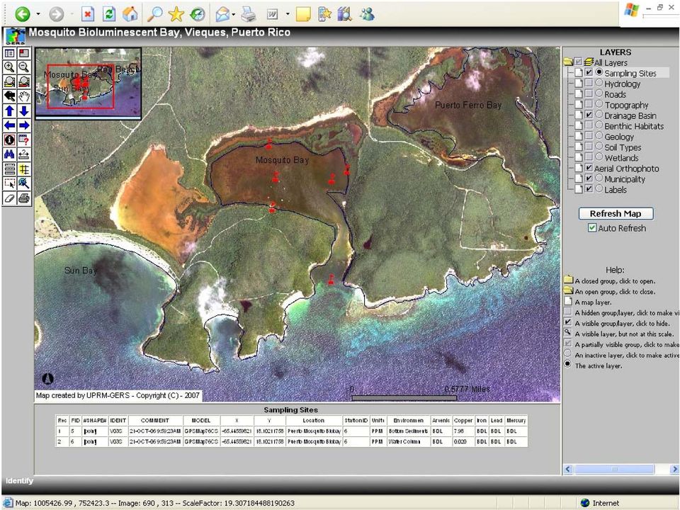
6 Research Projects Presence of heavy metals in La Parguera Bioluminescence Bay in Lajas, and Puerto Mosquito Bay in Vieques Differences in the characteristic of bioluminescence. Samples were collected from four different environments: bottom sediments under mangroves mangroves leaves bottom sediments water column. Sampling Mosquito Bay, Vieques

7 Data Table: GIS Data Layers used for Biobays Map Projects Layers Description Source(s) Location Used Sampling Sites From heavy metals study GERS LAB Mosquito Bay, Parguera Bay Hydrology Surface hydrology USGS Mosquito Bay, Parguera Bay Roads Major roads JP, DTOP Mosquito Bay, Parguera Bay Topography Elevation contours USGS Mosquito Bay, Parguera Bay Drainage basin Delimiting drainage basin USGS, JP Mosquito Bay, Parguera Bay Benthic Habitats Benthic community types NOAA Mosquito Bay, Parguera Bay Geology Major geological feaures USGS Mosquito Bay, Parguera Bay Soil Types Soil Types and Series NRCS-USDA Mosquito Bay, Parguera Bay Wetlands Wetland features distribution USFWS Mosquito Bay, Parguera Bay Aerial Orthophotos Aerial Photography (2004) US-COI, NRCS-USDA Mosquito Bay IKONOS image Satellite imagery (2007??) UPRM-GERS Parguera Bay Municipality Puerto Rico Municipality name JP Mosquito Bay, Parguera Bay Labels Important Places UPRM-GERS Mosquito Bay, Parguera Bay Aerial Orthophotos Aerial Photography (1999) NOAA Parguera Bay
 US-COI, NRCS-USDA Mosquito Bay IKONOS")
8 Web Publishing ArcMap Project (.mxd) ArcIMS Administrator New Service Image Server Arcmap ArcIMS Designer HTML Viewer Customize Viewer Elements Table of contents, tools, layout, etc. HTML Viewer for each site. Mosquito Biobay. Parguera Biobay. Web Page development

9

10
11

12
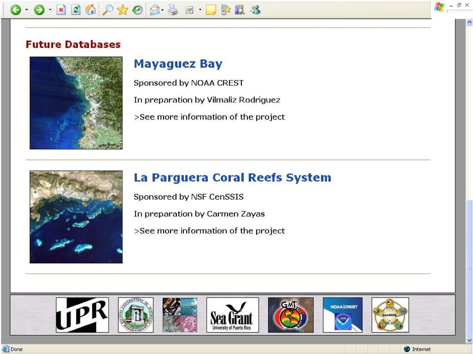
13 GERSVIEW Research Projects 1. Parguera and Mosquito Biobays 2. Parguera Reefs 3. Mayaguez Bay Watershed 4. Bio-Optical Properties of Mayaguez Bay 5. Bio-Optical Algorithms in Coastal Waters GERSVIEW ArcIMS Mapping Interface ArcIMS Mapping Interface (Power Users, Researchers) Central GDB Raster Catalog (Data) ArcView/Info Projects
 Central GDB Raster Catalog (Data)")
14 Conclusions Spatial Data Organization using a Geodatabase Tool for Web Mapping Interactive Project Publication platform Enable non-gis-users to access the spatial data Puerto Mosquito, Vieques

15 Projections Include Geodatabase projects for Mayaguez Bay and Parguera Reefs Enhance HTML Viewer Hierarchical Table of Contents Hyperlinks, Graphics, etc. Enable Java Viewer Obtain a New Server Better storage and processing Upgrade to ArcIMS 9.2 Include RS imagery analysis products (ENVI, ERDAS).

16 Acknowledgements Sponsored by: Data Sources:

17 Questions?

Mapping Mashup/Data Integration Development Resources Teaching with Google Earth and Google Ocean Stone Lab August 13, 2010
 Mapping Mashup/Data Integration Development Resources Teaching with Google Earth and Google Ocean Stone Lab August 13, 2010 David Hart GIS Specialist University of Wisconsin Sea Grant Institute Virtual
ArcGIS Data Models Practical Templates for Implementing GIS Projects
 ArcGIS Data Models Practical Templates for Implementing GIS Projects GIS Database Design According to C.J. Date (1995), database design deals with the logical representation of data in a database. The
Natural Resource-Based Planning*
 Natural Resource-Based Planning* Planning, when done well, is among the most powerful tools available to communities. A solid plan, based on good natural resource information, guides rational land-use
Mapping Mashup/Data Integration Development Resources
 Mapping Mashup/Data Integration Development Resources David Hart GIS Specialist University of Wisconsin Sea Grant Institute October 6, 2008 Virtual Globes A virtual globe is a 3D software model or representation
A GIS helps you answer questions and solve problems by looking at your data in a way that is quickly understood and easily shared.
 A Geographic Information System (GIS) integrates hardware, software, and data for capturing, managing, analyzing, and displaying all forms of geographically referenced information. GIS allows us to view,
How to do it Manual No. 3: ArcMap10 in Remote Desktop mode and Landgate slip files. Jeremy Green
 How to do it Manual No. 3: ArcMap10 in Remote Desktop mode and Landgate slip files Jeremy Green Report Department of Maritime Archaeology No. 268 2010 Getting started with ArcInfo10 The ArcInfo10 exists
Conservation Workshop ArcGIS Explorer
 Conservation Workshop ArcGIS Explorer Bern Szukalski [email protected] Topics for this session Introduction Overview of features Using ArcGIS Explorer effectively New features & capabilities Customization
Project Title: Project PI(s) (who is doing the work; contact Project Coordinator (contact information): information):
 (who is doing the work; contact Project Coordinator (contact information): information):") Project Title: Great Northern Landscape Conservation Cooperative Geospatial Data Portal Extension: Implementing a GNLCC Spatial Toolkit and Phenology Server Project PI(s) (who is doing the work; contact
Project Title: Great Northern Landscape Conservation Cooperative Geospatial Data Portal Extension: Implementing a GNLCC Spatial Toolkit and Phenology Server Project PI(s) (who is doing the work; contact
Remote Sensing, GPS and GIS Technique to Produce a Bathymetric Map
 Remote Sensing, GPS and GIS Technique to Produce a Bathymetric Map Mark Schnur EES 5053 Remote Sensing Fall 2007 University of Texas at San Antonio, Department of Earth and Environmental Science, San Antonio,
WHAT IS GIS - AN INRODUCTION
 WHAT IS GIS - AN INRODUCTION GIS DEFINITION GIS is an acronym for: Geographic Information Systems Geographic This term is used because GIS tend to deal primarily with geographic or spatial features. Information
GIS Architecture and Data Management Practices Boone County GIS Created and Maintained by the Boone County Planning Commission GIS Services Division
 GIS Architecture and Data Management Practices Boone County GIS Created and Maintained by the Boone County Planning Commission June 2008 Background Boone County s GIS program has been in existence for
Can GIS Help You Manage Water Resources? Erika Boghici Texas Natural Resources Information Systems
 Can GIS Help You Manage Water Resources? Erika Boghici Texas Natural Resources Information Systems Hydrologic Information System Hydrologic Modeling Arc Hydro Geodatabase Arc Hydro Data Model: combination
Coastal Engineering Indices to Inform Regional Management
 Coastal Engineering Indices to Inform Regional Management Lauren Dunkin FSBPA 14 February 2013 Outline Program overview Standard products Coastal Engineering Index Conclusion and future work US Army Corps
Creating the US Topo
 Creating the US Topo A Process Discussion National Geospatial Program Office National Geospatial Technical Operations Center Helmut Lestinsky Graphics Product Specialist MOD Project Manager U.S. Department
Geographic Information Systems (GIS) @ GIS at UCSD. Here to help you explore our world
 @ GIS at UCSD. Here to help you explore our world") Geographic Information Systems (GIS) @ GIS at UCSD Here to help you explore our world GIS at UCSD what it is and what it means to you Tracey Hughes UCSD GIS Coordinator 2006 Image from Google Earth An
Geographic Information Systems (GIS) @ GIS at UCSD Here to help you explore our world GIS at UCSD what it is and what it means to you Tracey Hughes UCSD GIS Coordinator 2006 Image from Google Earth An
Expert Review and Questionnaire (PART I)
") NASA ARC Project 1-9-2001 Web-based Geospatial Information Services and Analytic Tools for Habitat Conservation and Management Expert Review and Questionnaire (PART I) Thank you for participating in this
NASA ARC Project 1-9-2001 Web-based Geospatial Information Services and Analytic Tools for Habitat Conservation and Management Expert Review and Questionnaire (PART I) Thank you for participating in this
Geospatial Information for disaster risk reduction and natural resources management. Rolando Ocampo Alcántar
 Geospatial Information for disaster risk reduction and natural resources management Rolando Ocampo Alcántar Content Background Geospatial Information for Disaster Management Risk Atlas Information Exchange
Implementation of a Web Portal for Managing and Sharing Environmental Data
 Implementation of a Web Portal for Managing and Sharing Environmental Data Prepared for: 2011 DoD Environmental Monitoring & Data Quality Workshop Presented by: Jason Samus EA Engineering, Science and
NASA DEVELOP s 3-D Visualizations and Remote Sensing Applications. NASA DEVELOP, a student-led project headquartered at NASA Langley, allows
 Abstract NASA DEVELOP, a student-led project headquartered at NASA Langley, allows students to demonstrate remote-sensing techniques that are used to create visualizations, which aid communities in solving
Oklahoma s Open Source Spatial Data Clearinghouse: OKMaps
 Oklahoma s Open Source Spatial Data Clearinghouse: OKMaps Presented by: Mike Sharp State Geographic Information Coordinator Oklahoma Office of Geographic Information MAGIC 2014 Symposium April 28-May1,
ArcGIS Reference Document
 Migration of GIS Data to ArcSDE Page 1 of 10 Table of Contents A Brief Summary of DEP s GIS Data Storage o The Y Drive o ArcSDE (Spatial Database) Keeping Your GIS Project Data Current o Checking Your
Figure 2: System Flow Diagram for Workflow Management
 5. WORKFLOW MANAGEMENT The developed system EASKB uses the open source content management system called Drupal ([2]). A Content Management System - CMS is a tool that enables many user friendly features
GEOGRAPHIC INFORMATION SYSTEMS Lecture 20: Adding and Creating Data
 Adding Existing Data Into ArcGIS - there are many different ways to get data into ArcGIS GEOGRAPHIC INFORMATION SYSTEMS Lecture 20: Adding and Creating Data Add Data - normally we use the Add Data button
Risk Analysis, GIS and Arc Schematics: California Delta Levees
 Page 1 of 7 Author: David T. Hansen Risk Analysis, GIS and Arc Schematics: California Delta Levees Presented by David T. Hansen at the ESRI User Conference, 2008, San Diego California, August 6, 2008 Abstract
Server GIS. What Server GIS software do we provide?
 Server GIS Distribute maps, models, and tools via the Web in a way that fits well into your workflows. SuperGeo offers numerous Server GIS solutions to fulfill the demands of corporate Intranets and the
The Use of Geographic Information Systems in Risk Assessment
 The Use of Geographic Information Systems in Risk Assessment With Specific Focus on the RiVAMP Methodology Presented by Nadine Brown August 27, 2012 Climate Studies Group Mona Climate Change Workshop Presentation
Files Used in this Tutorial
 Generate Point Clouds Tutorial This tutorial shows how to generate point clouds from IKONOS satellite stereo imagery. You will view the point clouds in the ENVI LiDAR Viewer. The estimated time to complete
Lecture 8. Online GIS
 Lecture 8 Online GIS Lecture 8: Outline I. Online GIS 1. Google Earth 2. MSN Live Maps II. Open Source GIS III. ArcGIS Server and the ESRI suite of online software utility options IV. Advanced Data Mining
Australian Hydrological Geospatial Fabric (Geofabric) Tutorial. Access Water Storage information
 Tutorial. Access Water Storage information") Australian Hydrological Geospatial Fabric (Geofabric) Tutorial Access Water Storage Version 2.1 November 2012 Contact details Geospatial Data Unit Bureau of Meteorology GPO Box 2334 CANBERRA ACT 2601
Australian Hydrological Geospatial Fabric (Geofabric) Tutorial Access Water Storage Version 2.1 November 2012 Contact details Geospatial Data Unit Bureau of Meteorology GPO Box 2334 CANBERRA ACT 2601
Understanding Raster Data
 Introduction The following document is intended to provide a basic understanding of raster data. Raster data layers (commonly referred to as grids) are the essential data layers used in all tools developed
Michigan Tech Research Institute Wetland Mitigation Site Suitability Tool
 Michigan Tech Research Institute Wetland Mitigation Site Suitability Tool Michigan Tech Research Institute s (MTRI) Wetland Mitigation Site Suitability Tool (WMSST) integrates data layers for eight biophysical
A quick overview of geographic information systems (GIS) Uwe Deichmann, DECRG <[email protected]>
 Uwe Deichmann, DECRG <udeichmann@worldbank.org>") A quick overview of geographic information systems (GIS) Uwe Deichmann, DECRG Why is GIS important? A very large share of all types of information has a spatial component ( 80
A quick overview of geographic information systems (GIS) Uwe Deichmann, DECRG Why is GIS important? A very large share of all types of information has a spatial component ( 80
CRMS Website Training
 CRMS Website Training March 2013 http://www.lacoast.gov/crms Coastwide Reference Monitoring System - Wetlands CWPPRA Restoration Projects Congressionally funded in 1990 Multiple restoration techniques
ArcGIS Platform. An Integrated System. Portal
 Platform An Integrated System Portal An Integrated Web GIS Platform Knowledge Workers Executive Access Public Engagement Work Anywhere Enterprise Integration Providing Mapping, Analysis, Data Management,
Web-based GIS Application of the WEPP Model
 Web-based GIS Application of the WEPP Model Dennis C. Flanagan Research Agricultural Engineer USDA - Agricultural Research Service National Soil Erosion Research Laboratory West Lafayette, Indiana, USA
ROSE CREEK WATERSHED HYDROLOGIC, HYDRAULIC, SEDIMENT TRANSPORT, AND GEOMORPHIC ANALYSES TASK 1 EXISTING DATA AND INFORMATION SUMMARY REPORT BACKGROUND
 ROSE CREEK WATERSHED HYDROLOGIC, HYDRAULIC, SEDIMENT TRANSPORT, AND GEOMORPHIC ANALYSES TASK 1 EXISTING DATA AND INFORMATION SUMMARY REPORT BACKGROUND The Rose Creek Watershed (RCW) consists of three planning
REGIONAL SEDIMENT MANAGEMENT: A GIS APPROACH TO SPATIAL DATA ANALYSIS. Lynn Copeland Hardegree, Jennifer M. Wozencraft 1, Rose Dopsovic 2 INTRODUCTION
 REGIONAL SEDIMENT MANAGEMENT: A GIS APPROACH TO SPATIAL DATA ANALYSIS Lynn Copeland Hardegree, Jennifer M. Wozencraft 1, Rose Dopsovic 2 ABSTRACT: Regional sediment management (RSM) requires the capability
The Marine Protected Area Inventory
 The Marine Protected Area Inventory New pictures Jordan Gass, Hugo Selbie and Charlie Wahle ESRI Ocean Forum November 6, 2013 Outline What is the MPA Inventory? Purpose Data How it s used Future directions
Climate Change and Coral Bleaching in Puerto Rico: Efforts and Challenges
 Climate Change and Coral Bleaching in Puerto Rico: Efforts and Challenges June 18-20, 2003 Oahu, Hawaii 1 2 Aileen T. Velazco-Domínguez, MS Puerto Rico Department of Natural and Environmental Resources
Five Steps to Better Performance
 Effective Web maps have a specific focus and are designed so users can interact with them to accomplish meaningful tasks. Five Steps to Better Performance Sample methodology for creating a great Web map
INTRODUCTION TO ARCGIS SOFTWARE
 INTRODUCTION TO ARCGIS SOFTWARE I. History of Software Development a. Developer ESRI - Environmental Systems Research Institute, Inc., in 1969 as a privately held consulting firm that specialized in landuse
DATA SHARING AND SPATIAL QUERY
 Technical Memorandum No. 2 DATA SHARING AND SPATIAL QUERY Raghavan Srinivasan Spatial Sciences Laboratory Texas Agricultural Experiment Station, Texas A&M University Submitted to El Paso Water Utilities
The Courses. Covering complete breadth of GIS technology from ESRI including ArcGIS, ArcGIS Server and ArcGIS Engine.
 ESRI India: Corporate profile ESRI India A profile India s Premier GIS Company Strategic alliance between ESRI Inc. and NIIT Technologies Adjudged as India s Best GIS Solutions Company - Map India 2001
Geographical Information Systems An Overview
 Geographical Information Systems An Overview Arul Prakash : 98004 [email protected] Indian Institute of Information Technology Abstract Although many GIS have been successfully implemented, it has become
Introduction to Imagery and Raster Data in ArcGIS
 Esri International User Conference San Diego, California Technical Workshops July 25, 2012 Introduction to Imagery and Raster Data in ArcGIS Simon Woo slides Cody Benkelman - demos Overview of Presentation
Development of information management system of dams in China based on. WebGIS
 Development of information management system of dams in China based on WebGIS ZHU Xing-ming 1, GENG Qing-zhai 1,2 (1.China Institute of Water Resources and Hydropower Research, Beijing 100044, China, [email protected];
Development of an Impervious-Surface Database for the Little Blackwater River Watershed, Dorchester County, Maryland
 Development of an Impervious-Surface Database for the Little Blackwater River Watershed, Dorchester County, Maryland By Lesley E. Milheim, John W. Jones, and Roger A. Barlow Open-File Report 2007 1308
INSTITUTE OF HUMAN RESOURSE ADVANCEMENT (IHRA) UNIVERSITY OF COLOMBO. M. Sc. in Geoinformatics 2014/2015
 UNIVERSITY OF COLOMBO. M. Sc. in Geoinformatics 2014/2015") INSTITUTE OF HUMAN RESOURSE ADVANCEMENT (IHRA) UNIVERSITY OF COLOMBO Introduction M. Sc. in Geoinformatics 2014/2015 Course Conducted by the -IHRA, University of Colombo The Master of Science in Geoinformatics
INSTITUTE OF HUMAN RESOURSE ADVANCEMENT (IHRA) UNIVERSITY OF COLOMBO Introduction M. Sc. in Geoinformatics 2014/2015 Course Conducted by the -IHRA, University of Colombo The Master of Science in Geoinformatics
Advanced Image Management using the Mosaic Dataset
 Esri International User Conference San Diego, California Technical Workshops July 25, 2012 Advanced Image Management using the Mosaic Dataset Vinay Viswambharan, Mike Muller Agenda ArcGIS Image Management
Geodatabase Programming with SQL
 DevSummit DC February 11, 2015 Washington, DC Geodatabase Programming with SQL Craig Gillgrass Assumptions Basic knowledge of SQL and relational databases Basic knowledge of the Geodatabase We ll hold
CDA Information Technology: Fiber To the Home
 C O E U R D A L E N E T R I B E I N F O R M A T I O N T E C H N O L O GY GIS Program Spring 2014 Volume 1, Issue 1 GIS Program plans for new imagery of Reservation Inside this issue: Fiber to Home 2 WWP
Martin County Coastal GIS Program St Lucie Inlet Planning Tool
 Martin County Coastal GIS Program St Lucie Inlet Planning Tool Alexandra Carvalho, Ph.D., GISP Kathy Fitzpatrick, P.E. Jessica Garland Martin County, Florida Presentation Overview County Coastal Programs
APPLICATION OF MULTITEMPORAL LANDSAT DATA TO MAP AND MONITOR LAND COVER AND LAND USE CHANGE IN THE CHESAPEAKE BAY WATERSHED
 APPLICATION OF MULTITEMPORAL LANDSAT DATA TO MAP AND MONITOR LAND COVER AND LAND USE CHANGE IN THE CHESAPEAKE BAY WATERSHED S. J. GOETZ Woods Hole Research Center Woods Hole, Massachusetts 054-096 USA
CRMS Website Training March 2015
 CRMS Website Training March 2015 http://www.lacoast.gov/crms CWPPRA Restoration Program CWPPRA was congressionally funded in 1990 and mandated 20 years of restoration project monitoring CWPPRA program
ENVI THE PREMIER SOFTWARE FOR EXTRACTING INFORMATION FROM GEOSPATIAL IMAGERY.
 ENVI THE PREMIER SOFTWARE FOR EXTRACTING INFORMATION FROM GEOSPATIAL IMAGERY. ENVI Imagery Becomes Knowledge ENVI software uses proven scientific methods and automated processes to help you turn geospatial
Chapter 1: Introduction to ArcGIS Server
 Chapter 1: Introduction to ArcGIS Server At a high level you can think of ArcGIS Server as software that helps you take your geographic information and make it available to others. This data can be distributed
Institute of Natural Resources Departament of General Geology and Land use planning Work with a MAPS
 Institute of Natural Resources Departament of General Geology and Land use planning Work with a MAPS Lecturers: Berchuk V.Y. Gutareva N.Y. Contents: 1. Qgis; 2. General information; 3. Qgis desktop; 4.
Publishing geospatial data to the web using the EEA infrastructure
 Publishing geospatial data to the web using the EEA infrastructure *Note: Map Services should be published using the EEA Map Services Tick Sheet for guidance. Contact Sebastien Petit ([email protected])
GIS MAPPING FOR IRRIGATION DISTRICT RAPID APPRAISALS Daniel J. Howes 1, Charles M. Burt 2, Stuart W. Styles 3 ABSTRACT
 GIS MAPPING FOR IRRIGATION DISTRICT RAPID APPRAISALS Daniel J. Howes 1, Charles M. Burt 2, Stuart W. Styles 3 ABSTRACT Geographic information system (GIS) mapping is slowly becoming commonplace in irrigation
5. GIS, Cartography and Visualization of Glacier Terrain
 5. GIS, Cartography and Visualization of Glacier Terrain 5.1. Garhwal Himalayan Glaciers 5.1.1. Introduction GIS is the computer system for capturing, storing, analyzing and visualization of spatial and
GIS Initiative: Developing an atmospheric data model for GIS. Olga Wilhelmi (ESIG), Jennifer Boehnert (RAP/ESIG) and Terri Betancourt (RAP)
, Jennifer Boehnert (RAP/ESIG) and Terri Betancourt (RAP)") GIS Initiative: Developing an atmospheric data model for GIS Olga Wilhelmi (ESIG), Jennifer Boehnert (RAP/ESIG) and Terri Betancourt (RAP) Unidata seminar August 30, 2004 Presentation Outline Overview
GIS Initiative: Developing an atmospheric data model for GIS Olga Wilhelmi (ESIG), Jennifer Boehnert (RAP/ESIG) and Terri Betancourt (RAP) Unidata seminar August 30, 2004 Presentation Outline Overview
Statement of Qualifications
 Statement of Qualifications Prepared By: JAYA Corporation 4900 University Square, Suite 30 Huntsville, AL 35816 TEL: (256) 722-0700 FAX: (256) 722-0711 EMAIL: igis@jaya corp.com Small Disadvantaged Business,
What is ArcGIS Comprised Of?
 ArcGIS Server 9.1 What is ArcGIS Comprised Of? ArcGIS Desktop Integrated suite of GIS applications ArcGIS Engine Embeddable developer components Server GIS ArcSDE, ArcIMS, ArcGIS Server Mobile GIS ArcPad
SIO 296 Marine GIS Winter 2015
 SIO 296 Marine GIS Winter 2015 Instructor: Office hours: Heidi Batchelor Monday 4-5, Wednesday 11:30-12:30 [email protected] MESOM 157 Appointments suggested 858 534-1732 Course Syllabus Marine GIS is
Getting Started With LP360
 Getting Started With LP360 10/30/2014 1 Contents What is LP360?... 3 System Requirements... 3 Installing LP360... 4 How to Enable the LP360 Extension... 4 How to Display the LP360 Toolbar... 4 How to Import
National Centre for Sustainable Coastal Management. Advertisement for Selection of Project Staff
 F. : 2-8(7)/HR/NCSCM/2014 National Centre for Sustainable Coastal Management (Ministry of Environment, Forests and Climate Change, Govt. of India) Koodal Building, Anna University Campus, Chennai 600025,
DEVELOPMENT OF WEB-BASED GIS INTERFACES FOR APPLICATION OF THE WEPP MODEL
 DEVELOPMENT OF WEB-BASED GIS INTERFACES FOR APPLICATION OF THE WEPP MODEL D.C. Flanagan A, J.R. Frankenberger A, C.S. Renschler B and B.A. Engel C A National Soil Erosion Research Laboratory, USDA-ARS,
Geographic Information System Tools for Management of US DOE Sites 14125
 Geographic Information System Tools for Management of US DOE Sites 14125 John Montgomery*, Cliff Carpenter*, Leonard Turton**, Steve Pawel** *US DOE, Office of Legacy Management **S.M. Stoller Corporation
A Method Using ArcMap to Create a Hydrologically conditioned Digital Elevation Model
 A Method Using ArcMap to Create a Hydrologically conditioned Digital Elevation Model High resolution topography derived from LiDAR data is becoming more readily available. This new data source of topography
North Dakota GIS Program Report To Governor Jack Dalrymple. July 1, 2011 June 30, 2012
 North Dakota GIS Program Report To Governor Jack Dalrymple July 1, 2011 June 30, 2012 Executive Order 2001-06: The committee shall issue a report to the Governor's office at the end of each fiscal year,
Fort Dodge Stormwater Master Planning. Prepared By: Ralph C. Stark, Jr., P.E., C.F.M. Joel N. Krause, P.E., C.F.M.
 Fort Dodge Stormwater Master Planning Prepared By: Ralph C. Stark, Jr., P.E., C.F.M. Joel N. Krause, P.E., C.F.M. Project Location Project Background Flooding History Localized flooding and storm sewer
Massoud Abd El-aty Massoud Aly
 (CURRICULUM VITAE) Massoud Abd El-aty Massoud Aly BIRTH DATE: 1/10/1960 MARTIAL STATUS: Married + 4 Work: (Tel. & Fax: 009663-5816611, Tel. Central: 5816600 Ext. 2165) Home: (009663-5806832, 00203-5737434)
HELCOM Data and Map Service. User Manual
 HELCOM Data and Map Service User Manual Version 2.2 - February 2015 1 Table of contents 1. General Information... 3 1.1 Background... 3 1.2 Technical requirements... 3 1.3 Contact... 3 2. Accessing HELCOM
How To Build Gis Applications With An Arcgis Engine
 Delivering Custom GIS Applications With ArcGIS Engine An ESRI White Paper February 2004 ESRI 380 New York St., Redlands, CA 92373-8100, USA TEL 909-793-2853 FAX 909-793-5953 E-MAIL [email protected] WEB www.esri.com
Principles and Practices of Data Integration
 Data Integration Data integration is the process of combining data of different themes, content, scale or spatial extent, projections, acquisition methods, formats, schema, or even levels of uncertainty,
http://www.esri.com/bia
 ArcGIS for Tribal Transportation Management David Gadsden Federal Account Manager [email protected] d d 1 David Gadsden GIS Background UW Geography (1995) Peace Corps Tanzania Environmental Social Science
Department of Civil Engineering Doctor of Philosophy (Ph.D.) Degree Requirements Area of Study: Water Resources Engineering
 Degree Requirements Area of Study: Water Resources Engineering") Department of Civil Engineering Doctor of Philosophy (Ph.D.) Degree Requirements Area of Study: Water Resources Engineering The Doctor of Philosophy (Ph.D.) degree requires 64 credit hours of approved
Department of Civil Engineering Doctor of Philosophy (Ph.D.) Degree Requirements Area of Study: Water Resources Engineering The Doctor of Philosophy (Ph.D.) degree requires 64 credit hours of approved
ANALYSIS 3 - RASTER What kinds of analysis can we do with GIS?
 ANALYSIS 3 - RASTER What kinds of analysis can we do with GIS? 1. Measurements 2. Layer statistics 3. Queries 4. Buffering (vector); Proximity (raster) 5. Filtering (raster) 6. Map overlay (layer on layer
Application of GIS Analyzes with Cloud Computing
 ion of GIS Analyzes with Cloud Computing Sevket BEDIROGLU, Volkan YILDIRIM and Selcuk ERBAS (Turkey) Key words: GIS, Cloud Computing, Spatial Cloud Computing SUMMARY Usage of Cloud Computing (CC) has been
Introduction to GIS (Basics, Data, Analysis) & Case Studies. 13 th May 2004. Content. What is GIS?
 & Case Studies. 13 th May 2004. Content. What is GIS?") Introduction to GIS (Basics, Data, Analysis) & Case Studies 13 th May 2004 Content Introduction to GIS Data concepts Data input Analysis Applications selected examples What is GIS? Geographic Information
Introduction to GIS (Basics, Data, Analysis) & Case Studies 13 th May 2004 Content Introduction to GIS Data concepts Data input Analysis Applications selected examples What is GIS? Geographic Information
A HYDROLOGIC NETWORK SUPPORTING SPATIALLY REFERENCED REGRESSION MODELING IN THE CHESAPEAKE BAY WATERSHED
 A HYDROLOGIC NETWORK SUPPORTING SPATIALLY REFERENCED REGRESSION MODELING IN THE CHESAPEAKE BAY WATERSHED JOHN W. BRAKEBILL 1* AND STEPHEN D. PRESTON 2 1 U.S. Geological Survey, Baltimore, MD, USA; 2 U.S.
The UCC-21 cognitive skills that are listed above will be met via the following objectives.
 Master Syllabus Department of Geography GEOG 265: Introduction to Geographic Information Systems Course Description Fundamentals of geographic information systems (GIS). How to visualize geographic information
GEOGRAPHIC INFORMATION SYSTEMS (GIS) at San Francisco State University
 at San Francisco State University") SF STATE Extended Learning 2013/2014 Learn to use state-of-the-art mapping systems to turn data into information. GEOGRAPHIC INFORMATION SYSTEMS (GIS) at San Francisco State University Use GIS in: BUSINESS
SF STATE Extended Learning 2013/2014 Learn to use state-of-the-art mapping systems to turn data into information. GEOGRAPHIC INFORMATION SYSTEMS (GIS) at San Francisco State University Use GIS in: BUSINESS
Pima Regional Remote Sensing Program
 Pima Regional Remote Sensing Program Activity Orthophoto GIS Mapping and Analysis Implementing Agency Pima Association of Governments (Tucson, Arizona area Metropolitan Planning Organization) Summary Through
Introduction to GIS. http://libguides.mit.edu/gis
 Introduction to GIS http://libguides.mit.edu/gis 1 Overview What is GIS? Types of Data and Projections What can I do with GIS? Data Sources and Formats Software Data Management Tips 2 What is GIS? 3 Characteristics