Big Data Analytics for Detailed Urban Mapping. Mihai Datcu Daniela Molina Espinoza, Octavian Dumitru, Gottfried Schwarz
|
|
|
- Kevin Payne
- 10 years ago
- Views:
Transcription
1 Big Data Analytics for Detailed Urban Mapping Mihai Datcu Daniela Molina Espinoza, Octavian Dumitru, Gottfried Schwarz

2 Big Data: The German EO Digital Library The data access Folie 2

3 Information vs. Data ERS1 24-JUL x512 pixels TerraSAR-X 11-OCT x512 pixels Folie 3

4 Folie 4
5 EOLib: Earth Observation image Librarian EOLib is a modular system composed of several components: PGS in blue and new EOLib in orange EOLib offers mining/search services for accessing the image archive EOLib generates semantic Folie 5 descriptions of the image content D. Espinoza-Molina and M. Datcu, Earth-Observation Image Retrieval Based on Content, Semantics, and Metadata, IEEE TGARS, vol. 51, no. 11, pp , 2013.

6 EOLib: Data Mining and KDD new components Data Model Generation Data Mining DataBase Query Engine Visual Data Mining Knowledge Discovery in Databases Epitome Generation Folie 6

7 Data Model Generation Folie 7
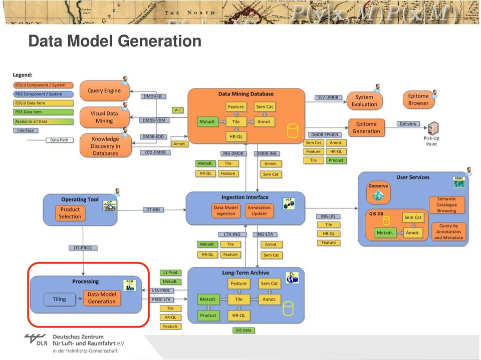
8 Data Model Generation TerraSAR-X L1b product TerraSAR-X image Tiles with different size Primitive features: Gabor filter and weber local descriptor Metadata Extraction Image Tiling Quick looks generation Primitive Feature extraction Create the product model Folie 8

9 Data Mining Database Folie 9

10 Data Mining Data Base It is a relational database DMDB comprises about 800 processed products 8. millions of tiles 20 thousand metadata entries. 106 semantic labels Folie 10

11 Query Engine Folie 11

12 Query Engine Metadata Coordinates (lat/lon) Incidence angles Acquisition time Pixel spacing Number of columns/ rows sensor Mission orbits Semantics Agriculture Cropland Rice plantation.. Bare ground Cliff Desert.. Forest Forest coniferous Forest mixed. Urban area Commercial areas High density residential areas. Metadata parameter based on XML annotation file of TerraSAR-X L1b products Semantic parameters based on EO Taxonomy Folie 12

13 Query Engine: Examples Example of query: Storage tanks and Medium density urban area are the query parameters Folie 13

14 Visual Data Mining Folie 14

15 Visual Data Mining Provides a projection of the entire database Representation of the data in the 3D space (dimensionality reduction) Interactive exploration and analysis of very large, high complexity data sets This allows the user: To browse the image archive To find scenes of interest Semantically consistent groups may appear inside the data Folie 15

16 Knowledge Discovery in Databases Folie 16

17 Knowledge Discovery in Databases KDD used to define semantic annotations of the image content. Interactive search supported b y r e l e v a n c e f e e d b a c k mechanisms Goals is to build a model which performs the mapping between low-level image descriptors (primitive features ) and high-level image concepts (semantics) Folie 17

18 KDD: GUI Work Flow: Classification SVM with RF Annotated category Collections Tiles Folie 18

19 Folie 19
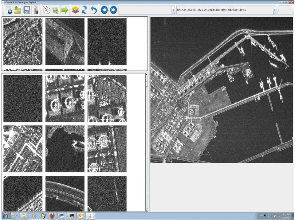
20 Cascaded Active Learning Level 0: 200x200 pixels Folie 20

21 Cascaded Active Learning Level 1: 100x100 pixels Folie 21
22 Cascaded Active Learning Level 2: 50x50 pixels Folie 22
23 Cascaded Active Learning Level 0 200x200 pixels Level 1 Refugee camp in Jordan 100x100 pixels Level 2 50x50 pixels Semantic Tents Sand category Folie 23
24 Cascaded Active Learning Level 0 200x200 pixels Level 1 100x100 pixels Petroleum storage area near Riffa, Bahrain Level 2 50x50 pixels Semantic Storage tanks Industrial buildings category Folie 24
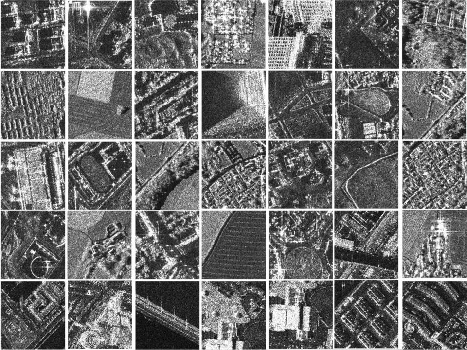
25 Ontology SAR images Tiling Patches Features Features Features Features Features Features Features Features Features Primitive features Classification Category 1 Category 2 Category 3 Category 4 Category n Annotation High density residential areas Airport - Runways Agriculture Boats Railways tracks Semantic catalogue Folie 25
26 Content Semantic Annotation Proposed three-level annotation scheme Settlements Inhabited built-up areas o High density residential areas.. Uninhabited built-up areas o Skyscrapers.. Industrial production areas Industrial facilities o Industrial buildings.. Industrial storage areas o Depots and dumps.. Military facilities Air force facilities.. Agriculture Greenhouses.. Natural vegetation Mixed forest.. Transport Airports o.. Roads o Runways Streets and roads.. Railways o Railway tracks.. Bridges and tunnels o Bridges and fly-overs.. Ports and shipbuilding facilities o Harbour infrastructure.. Water vessels o Small vessels (boats).. Bare ground Mountain.. Water bodies Buoys.. Folie 26
27 Content Semantic Annotation Folie 27
28 Semantic catalogues 350 cities 850 classes - Bangkok (Thailand); - Shenyang (China); - Nazca Lines (Peru); - Havana (Cuba); - Venice (Italy); - Vasteras (Sweden); - Oran (Algeria); - Bogota (Columbia) 28 Folie 28
29 Results: Venice Investigated area - Venice, Italy Validation our results were compared for the same area with CORINE Land Cover (CLC) categories. TSX image Further validation our results to be compared with Urban Atlas categories. Folie 29
30 Results: Venice Our classification 17 categories versus CLC 10 categories (CLC) CORINE Land Cover our classification!!! bridges, buoys, and sea categories of our proposed annotation method are included in marine waters coastal lagoons in the case of CLC Folie 30
31 Results: Venice Data analysis Percentage of patches per semantic category for Venice and a typical patch per category Folie 31
32 Results: Venice Quantitative results Precision / recall per semantic category for Venice Folie 32
33 SCENE CATEGORIES & INFORMATION CONTENT: BUCHAREST 1 HS TerraSAR-X Scene = up to image patches (100 x 100 m) Folie 33
34 Evaluation Evolution of precision/recall results among four categories (storage tanks, ships, ocean, and industrial areas) out of seven for all levels (left side) and for the finest-level (right side). Folie 34
35 Folie 35 Vortrag > Autor > Dokumentname > Datum
36 Disaster effects analysis The damages in the agriculture can be clearly seen by comparing the classification in pre disaster image (left figure) with the post disaster image (right figure). TerraSAR-X scene before Tsunami TerraSAR-X scene after Tsunami Agriculture Flooded areas Bridges Bridges Aquaculture Debris H. Voltage poles H. Voltage poles Folie 36
37 Data Analytics Folie 37
38 Conclusions Operational Data Mining, Visual Data Mining, KDD used to define semantic annotations of the image content. Interactive search supported by active learning mechanisms More than 1000 detailed categories of buildup scenes Time Series Exploration and Analysis Big Data Folie 38
39 Acknowledgment: The VDM component was developed by TERRASIGNA References P. Blanchart, P., M. Ferecatu, C. Shiyong Cui, M. Datcu, 2015, Pattern Retrieval in Large Image Databases Using Multiscale Coarse-to-Fine Cascaded Active Learning, IEEE Journal of Selected Topics in Applied Earth Observations and Remote Sensing, Volume: 7, Issue: 4, Pages: D. Molina Espinoza, M. Datcu, 2013, Earth-Observation Image Retrieval Based on Content, Semantics, and Metadata, IEEE Transactions on Geoscience and Remote Sensing, Vol. 51, No. 11, pp C. Dumitru, S. Cui, D. Faur, M. Datcu, 2014, Data Analytics for Rapid Mapping: Case Study of a Flooding Event in Germany and the Tsunami in Japan Using Very High Resolution SAR Images, IEEE Journal of Selected Topics in Applied Earth Observations and Remote Sensing,. O. Dumitru, M. Datcu, 2013, Information Content of Very High Resolution SAR Images: Study of Feature Extraction and Imaging Parameters. IEEE Transactions on Geoscience and Remote Sensing, Vol. 51, No. 8, pp M. Datcu, K. Seidel, 2005, Human Centered Concepts for Exploration and Understanding of Images, IEEE Trans. on Geoscience and Remote Sensing, ISSN , Vol. 43, No.3, pp M. Datcu, H. Daschiel, et al, 2003, Information mining in Remote Sensing Image Archives: System Description, IEEE Trans. on Geoscience and Remote Sensing, ISSN , Vol. 41, No. 12, pp Folie 39
Big Data Challenge: Mining Heterogeneous Data. Prof. Mihai Datcu. German Aerospace Center (DLR) Munich Aerospace Faculty
 Munich Aerospace Faculty") Big Data Challenge: Mining Heterogeneous Data Prof. Mihai Datcu German Aerospace Center (DLR) Munich Aerospace Faculty Sensing & Big Data Big Data: - Computer hardware and the Cloud - Storage Challenges
Big Data Challenge: Mining Heterogeneous Data Prof. Mihai Datcu German Aerospace Center (DLR) Munich Aerospace Faculty Sensing & Big Data Big Data: - Computer hardware and the Cloud - Storage Challenges
Modelling, Extraction and Description of Intrinsic Cues of High Resolution Satellite Images: Independent Component Analysis based approaches
 Modelling, Extraction and Description of Intrinsic Cues of High Resolution Satellite Images: Independent Component Analysis based approaches PhD Thesis by Payam Birjandi Director: Prof. Mihai Datcu Problematic
IEEE JOURNAL OF SELECTED TOPICS IN APPLIED EARTH OBSERVATIONS AND REMOTE SENSING 1
 IEEE JOURNAL OF SELECTED TOPICS IN APPLIED EARTH OBSERVATIONS AND REMOTE SENSING 1 Very-High-Resolution SAR Images and Linked Open Data Analytics Based on Ontologies Daniela Espinoza-Molina, Member, IEEE,
Comparison of ALOS-PALSAR and TerraSAR-X Data in terms of Detecting Settlements First Results
 ALOS 2008 Symposium, 3-7 November Rhodes, Greece Comparison of ALOS-PALSAR and TerraSAR-X Data in terms of Detecting Settlements First Results Thomas Esch*, Achim Roth*, Michael Thiel, Michael Schmidt*,
German Earth Observation Systems and Programs Capacities for nation building
 German Earth Observation Systems and Programs Capacities for nation building German Aerospace Center, DLR, Earth Observation Center, EOC German Remote Sensing Data Center, DFD Gunter Schreier Deputy Director
The following was presented at DMT 14 (June 1-4, 2014, Newark, DE).
.") DMT 2014 The following was presented at DMT 14 (June 1-4, 2014, Newark, DE). The contents are provisional and will be superseded by a paper in the DMT 14 Proceedings. See also presentations and Proceedings
DMT 2014 The following was presented at DMT 14 (June 1-4, 2014, Newark, DE). The contents are provisional and will be superseded by a paper in the DMT 14 Proceedings. See also presentations and Proceedings
June 2011. TerraSAR-X-based Flood Mapping Service
 June 2011 TerraSAR-X-based Flood Mapping Service Service TerraSAR-X-based Flood Mapping Product Flood extent map Product specifications Flood mask / water mask Input / output data Summary Content Date
Prediction of Storm Surge using Space Data. Susanne Lehner German Aerospace Center
 Prediction of Storm Surge using Space Data Susanne Lehner German Aerospace Center Existing Crisis Information State of the Art of Satellite Crisis Information (ZKI) Mapping after the storm www.zki.de
New Space Capabilities for Maritime Surveillance
 www.dlr.de ESA Blue Growth Marititime College, Cork, Ireland 17.4..2013 New Space Capabilities for Maritime Surveillance Susanne Lehner German Aerospace Center DLR Remote Sensing Technology Institute DLR
TerraSAR-X Interferometry. Michael Eineder, Nico Adam Remote Sensing Technology Institute
 TerraSAR-X Interferometry Michael Eineder, Nico Adam Remote Sensing Technology Institute TerraSAR-X Contribution to Commissioning Phase: verify phase and geometric stability of instrument and SAR processor
SEMANTIC CLASSIFICATION OF VERY HIGH RESOLUTION EARTH OBSERVATION IMAGE CONTENT BASED ON TOPOLOGICAL INFORMATION
 U.P.B. Sci. Bull., Series C, Vol. 74, Iss. 3, 2012. ISSN 1454-234x SEMANTIC CLASSIFICATION OF VERY HIGH RESOLUTION EARTH OBSERVATION IMAGE CONTENT BASED ON TOPOLOGICAL INFORMATION Corina VĂDUVA 1, Inge
The Scientific Data Mining Process
 Chapter 4 The Scientific Data Mining Process When I use a word, Humpty Dumpty said, in rather a scornful tone, it means just what I choose it to mean neither more nor less. Lewis Carroll [87, p. 214] In
ROSA ESA - DLR Course 2009 RADAR REMOTE SENSING Day 4-5
 ROSA ESA - DLR Course 2009 RADAR REMOTE SENSING Day 4-5 Dr. Jan-Peter Mund, André Twele & Sandro Martinis German Remote Sensing Data Center (DFD) German Aerospace Center (DLR) RADAR REMOTE SENSING Introduction
COASTAL MONITORING & OBSERVATIONS LESSON PLAN Do You Have Change?
 Coastal Change Analysis Lesson Plan COASTAL MONITORING & OBSERVATIONS LESSON PLAN Do You Have Change? NOS Topic Coastal Monitoring and Observations Theme Coastal Change Analysis Links to Overview Essays
Remote Sensing Applications in Support of Sustainable Development and Disaster Management by DLR Current Activities
 Remote Sensing Applications in Support of Sustainable Development and Disaster Management by DLR Current Activities Dr. Günter Strunz German Aerospace Center (DLR) German Remote Sensing Data Center 43rd
How To Write A Call To Action For Terrasar-X
 Doc.: TX-PGS-PL-4127 TerraSAR-X Announcement of Opportunity: Utilization of the TerraSAR-X Archive 1 Page: 2 of 11 TABLE OF CONTENTS TERRASAR-X... 1 ANNOUNCEMENT OF OPPORTUNITY: UTILIZATION OF THE TERRASAR-X
LARGE SCALE SATELLITE IMAGE PROCESSING USING HADOOP DISTRIBUTED SYSTEM
 LARGE SCALE SATELLITE IMAGE PROCESSING USING HADOOP DISTRIBUTED SYSTEM Sarade Shrikant D., Ghule Nilkanth B., Disale Swapnil P., Sasane Sandip R. Abstract- The processing of large amount of images is necessary
ISSN: 2348 9510. A Review: Image Retrieval Using Web Multimedia Mining
 A Review: Image Retrieval Using Web Multimedia Satish Bansal*, K K Yadav** *, **Assistant Professor Prestige Institute Of Management, Gwalior (MP), India Abstract Multimedia object include audio, video,
Digital Remote Sensing Data Processing Digital Remote Sensing Data Processing and Analysis: An Introduction and Analysis: An Introduction
 Digital Remote Sensing Data Processing Digital Remote Sensing Data Processing and Analysis: An Introduction and Analysis: An Introduction Content Remote sensing data Spatial, spectral, radiometric and
AERIAL PHOTOGRAPHS. For a map of this information, in paper or digital format, contact the Tompkins County Planning Department.
 AERIAL PHOTOGRAPHS What are Aerial Photographs? Aerial photographs are images of the land taken from an airplane and printed on 9 x9 photographic paper. Why are Aerial Photographs Important? Aerial photographs
River Flood Damage Assessment using IKONOS images, Segmentation Algorithms & Flood Simulation Models
 River Flood Damage Assessment using IKONOS images, Segmentation Algorithms & Flood Simulation Models Steven M. de Jong & Raymond Sluiter Utrecht University Corné van der Sande Netherlands Earth Observation
The use of Satellite Remote Sensing for Offshore Environmental Benchmarking
 The use of Satellite Remote Sensing for Offshore Environmental Benchmarking Michael King Fugro NPA Limited Fugro NPA (Formerly Nigel Press Associates) World leading Satellite Remote Sensing & Geoscience
Satellites for Terrain Motion Mapping Terrafirma User Workshop Mining. Nico Adam
 Satellites for Terrain Motion Mapping Terrafirma User Workshop Mining Nico Adam Outline SAR / InSAR observation characteristic Sensors TSX, TDX ERS-1, ERS-2 Processing techniques D-InSAR PSI SBAS Acquisition
Big Data Text Mining and Visualization. Anton Heijs
 Copyright 2007 by Treparel Information Solutions BV. This report nor any part of it may be copied, circulated, quoted without prior written approval from Treparel7 Treparel Information Solutions BV Delftechpark
The distribution of marine OpenData via distributed data networks and Web APIs. The example of ERDDAP, the message broker and data mediator from NOAA
 The distribution of marine OpenData via distributed data networks and Web APIs. The example of ERDDAP, the message broker and data mediator from NOAA Dr. Conor Delaney 9 April 2014 GeoMaritime, London
How To Use Inspire For Eo Data Processing
 INSPIREd computing for EO Based Services Paolo MANUNTA 1, Giulio CERIOLA 1, Jens STUTTE 1 1 Planetek Italia s.r.l Via Massaua 12 I-70132 Bari E-Mail: [email protected] Workshop Big Data Roma, 26/11/2013
CLASSIFICATION ACCURACY INCREASE USING MULTISENSOR DATA FUSION
 CLASSIFICATION ACCURACY INCREASE USING MULTISENSOR DATA FUSION Aliaksei Makarau, Gintautas Palubinskas, and Peter Reinartz German Aerospace Center (DLR) German Remote Sensing Data Center (DFD) bzw. Remote
Government 98dn Mapping Social and Environmental Space
 Government 98dn Mapping Social and Environmental Space LAB EXERCISE 5: The Analysis of Fields Objectives of this lab: Visualizing raster data Using Spatial Analyst functions to create new data Analysis
Data and Information Management for EO Data Centers. Eberhard Mikusch German Aerospace Center - German Remote Sensing Data Center
 Data and Information Management for EO Data Centers Eberhard Mikusch German Aerospace Center - Mexico, 23. 04 2008 Earth Observation System Environment at DLR/DFD 10010 00101 Radar 10010 00101 Atmospheric
Exploitation of historical satellite SAR archives for mapping and monitoring landslides at regional and local scale
 Exploitation of historical satellite SAR archives for mapping and monitoring landslides at regional and local scale (A. Ferretti (TRE), A. Tamburini (TRE), M. Bianchi (TRE), M. Broccolato (Regione Valle
RESULT, ANALYSIS AND DISCUSSION
 Chapter 6 RESULT, ANALYSIS AND DISCUSSION As we have already mentioned that our proposed methodology works in two phases, i.e., i) Application development when there is no in the database/application (First
Classification of High-Resolution Remotely Sensed Image by Combining Spectral, Structural and Semantic Features Using SVM Approach
 Classification of High-Resolution Remotely Sensed Image by Combining Spectral, Structural and Semantic Features Using SVM Approach I Saranya.K, II [email protected] I PG Student, II Assistant Professor
Information Services for Smart Grids
 Smart Grid and Renewable Energy, 2009, 8 12 Published Online September 2009 (http://www.scirp.org/journal/sgre/). ABSTRACT Interconnected and integrated electrical power systems, by their very dynamic
Remote Sensitive Image Stations and Grid Services
 International Journal of Grid and Distributed Computing 23 Remote Sensing Images Data Integration Based on the Agent Service Binge Cui, Chuanmin Wang, Qiang Wang College of Information Science and Engineering,
Remote Sensing and GIS Application In Change Detection Study In Urban Zone Using Multi Temporal Satellite
 Remote Sensing and GIS Application In Change Detection Study In Urban Zone Using Multi Temporal Satellite R.Manonmani, G.Mary Divya Suganya Institute of Remote Sensing, Anna University, Chennai 600 025
<is web> Information Systems & Semantic Web University of Koblenz Landau, Germany
 Information Systems University of Koblenz Landau, Germany Semantic Multimedia Management - Multimedia Annotation Tools http://isweb.uni-koblenz.de Multimedia Annotation Different levels of annotations
Object Recognition. Selim Aksoy. Bilkent University [email protected]
 Image Classification and Object Recognition Selim Aksoy Department of Computer Engineering Bilkent University [email protected] Image classification Image (scene) classification is a fundamental
Applications of Deep Learning to the GEOINT mission. June 2015
 Applications of Deep Learning to the GEOINT mission June 2015 Overview Motivation Deep Learning Recap GEOINT applications: Imagery exploitation OSINT exploitation Geospatial and activity based analytics
Weblogs Content Classification Tools: performance evaluation
 Weblogs Content Classification Tools: performance evaluation Jesús Tramullas a,, and Piedad Garrido a a Universidad de Zaragoza, Dept. of Library and Information Science. Pedro Cerbuna 12, 50009 [email protected]
Design of Data Archive in Virtual Test Architecture
 Journal of Information Hiding and Multimedia Signal Processing 2014 ISSN 2073-4212 Ubiquitous International Volume 5, Number 1, January 2014 Design of Data Archive in Virtual Test Architecture Lian-Lei
Clustering Big Data. Anil K. Jain. (with Radha Chitta and Rong Jin) Department of Computer Science Michigan State University November 29, 2012
 Department of Computer Science Michigan State University November 29, 2012") Clustering Big Data Anil K. Jain (with Radha Chitta and Rong Jin) Department of Computer Science Michigan State University November 29, 2012 Outline Big Data How to extract information? Data clustering
Clustering Big Data Anil K. Jain (with Radha Chitta and Rong Jin) Department of Computer Science Michigan State University November 29, 2012 Outline Big Data How to extract information? Data clustering
The Matsu Wheel: A Cloud-based Scanning Framework for Analyzing Large Volumes of Hyperspectral Data
 The Matsu Wheel: A Cloud-based Scanning Framework for Analyzing Large Volumes of Hyperspectral Data Maria Patterson, PhD Open Science Data Cloud Center for Data Intensive Science (CDIS) University of Chicago
An Automatic and Accurate Segmentation for High Resolution Satellite Image S.Saumya 1, D.V.Jiji Thanka Ligoshia 2
 An Automatic and Accurate Segmentation for High Resolution Satellite Image S.Saumya 1, D.V.Jiji Thanka Ligoshia 2 Assistant Professor, Dept of ECE, Bethlahem Institute of Engineering, Karungal, Tamilnadu,
Semantic SharePoint. Technical Briefing. Helmut Nagy, Semantic Web Company Andreas Blumauer, Semantic Web Company
 Semantic SharePoint Technical Briefing Helmut Nagy, Semantic Web Company Andreas Blumauer, Semantic Web Company What is Semantic SP? a joint venture between iquest and Semantic Web Company, initiated in
Research On The Classification Of High Resolution Image Based On Object-oriented And Class Rule
 Research On The Classification Of High Resolution Image Based On Object-oriented And Class Rule Li Chaokui a,b, Fang Wen a,b, Dong Xiaojiao a,b a National-Local Joint Engineering Laboratory of Geo-Spatial
The MELODIES project: Exploiting open data using cloud computing and Linked Data
 Dept. of Informatics and Telecommunications, National and Kapodistrian University of Athens, Greece The MELODIES project: Exploiting open data using cloud computing and Linked Data Stella Giannakopoulou
The Role of SPOT Satellite Images in Mapping Air Pollution Caused by Cement Factories
 The Role of SPOT Satellite Images in Mapping Air Pollution Caused by Cement Factories Dr. Farrag Ali FARRAG Assistant Prof. at Civil Engineering Dept. Faculty of Engineering Assiut University Assiut, Egypt.
Maritime accidents and safety investigations. Executive Director Dr. Veli-Pekka Nurmi
 Maritime accidents and safety investigations Executive Director Background for marine accident investigations Historically the maritime safety has improved through learning by experience. The practises
Review for Introduction to Remote Sensing: Science Concepts and Technology
 Review for Introduction to Remote Sensing: Science Concepts and Technology Ann Johnson Associate Director [email protected] Funded by National Science Foundation Advanced Technological Education program [DUE
Current Status and Considerations for the Future. Harald Mehl & Stefan Voigt German Aerospace Center (DLR)
") Current Status and Considerations for the Future Harald Mehl & Stefan Voigt German Aerospace Center (DLR) Supporting DLR s engagement in EO for civil security Contribution to the implementation of the
Current Status and Considerations for the Future Harald Mehl & Stefan Voigt German Aerospace Center (DLR) Supporting DLR s engagement in EO for civil security Contribution to the implementation of the
FUZZY CLUSTERING ANALYSIS OF DATA MINING: APPLICATION TO AN ACCIDENT MINING SYSTEM
 International Journal of Innovative Computing, Information and Control ICIC International c 0 ISSN 34-48 Volume 8, Number 8, August 0 pp. 4 FUZZY CLUSTERING ANALYSIS OF DATA MINING: APPLICATION TO AN ACCIDENT
Toma Danila Dragos. National Institute for Earth Physics Romania
 Toma Danila Dragos National Institute for Earth Physics Romania Before: evaluate the hazard and risk, be prepared for worst case scenario Natural or antropic disaster After: quickly evaluate the situation
72. Ontology Driven Knowledge Discovery Process: a proposal to integrate Ontology Engineering and KDD
 72. Ontology Driven Knowledge Discovery Process: a proposal to integrate Ontology Engineering and KDD Paulo Gottgtroy Auckland University of Technology [email protected] Abstract This paper is
How can we defend ourselves from the hazard of Nature in the modern society?
 How can we defend ourselves from the hazard of Nature in the modern society?, University of Bologna President of the EGU Division of Natural Hazards Email: [email protected] [email protected] GIFT 2013 Natural
 European Forest Data Centre Biosoil/Biodiversity Forest Type Map 2006 P. Kempeneers, JRC T. Durant F. Sedano, JRC L. Seebach, JRC J. San-Miguel-Ayanz, JRC EC -, IES Land Management and Natural Hazard Unit
An Assessment of the Effectiveness of Segmentation Methods on Classification Performance
 An Assessment of the Effectiveness of Segmentation Methods on Classification Performance Merve Yildiz 1, Taskin Kavzoglu 2, Ismail Colkesen 3, Emrehan K. Sahin Gebze Institute of Technology, Department
Satellite Monitoring of Urbanization in Megacities
 Satellite Monitoring of Urbanization in Megacities Yifang Ban Professor of Geoinformatics Department of Urban Planning & Environment KTH Royal Institute of Technology Stockholm, Sweden Introduction In
Databases in Organizations
 The following is an excerpt from a draft chapter of a new enterprise architecture text book that is currently under development entitled Enterprise Architecture: Principles and Practice by Brian Cameron
Masters of Safety & Security. EUCISE2020 Industry Day Brussels September 23, 2015 SIGNALIS Presentation
 Masters of Safety & Security EUCISE2020 Industry Day Brussels September 23, 2015 SIGNALIS Presentation Ability to offer an end-to-end solution C2 Software & System Integration Electronics RADARS Sonars
ABSTRACT INTRODUCTION PURPOSE
 EVALUATION OF TSUNAMI DISASTER BY THE 2011 OFF THE PACIFIC COAST OF TOHOKU EARTHQUAKE IN JAPAN BY USING TIME SERIES SATELLITE IMAGES WITH MULTI RESOLUTION Hideki Hashiba Associate Professor Department
DESCW: PC Software Supporting Remote Sensing Data
 r bulletin 97 march 1999 DESCW: PC Software Supporting Remote Sensing Data S. D Elia Earth Remote Sensing Exploitation Division, ESA Directorate for Application Programmes, ESRIN, Frascati, Italy R. Biasutti
Enabling Semantic Search in Geospatial Metadata Catalogue to Support Polar Sciences
 Enabling Semantic Search in Geospatial Metadata Catalogue to Support Polar Sciences Wenwen Li 1 and Vidit Bhatia 2 1 GeoDa Center for Geospatial Analysis and Computation School of Geographical Sciences
Flattening Enterprise Knowledge
 Flattening Enterprise Knowledge Do you Control Your Content or Does Your Content Control You? 1 Executive Summary: Enterprise Content Management (ECM) is a common buzz term and every IT manager knows it
Synthetic Aperture Radar: Principles and Applications of AI in Automatic Target Recognition
 Synthetic Aperture Radar: Principles and Applications of AI in Automatic Target Recognition Paulo Marques 1 Instituto Superior de Engenharia de Lisboa / Instituto de Telecomunicações R. Conselheiro Emídio
'Developments and benefits of hydrographic surveying using multispectral imagery in the coastal zone
 Abstract With the recent launch of enhanced high-resolution commercial satellites, available imagery has improved from four-bands to eight-band multispectral. Simultaneously developments in remote sensing
Web 3.0 image search: a World First
 Web 3.0 image search: a World First The digital age has provided a virtually free worldwide digital distribution infrastructure through the internet. Many areas of commerce, government and academia have
Hyperspectral Satellite Imaging Planning a Mission
 Hyperspectral Satellite Imaging Planning a Mission Victor Gardner University of Maryland 2007 AIAA Region 1 Mid-Atlantic Student Conference National Institute of Aerospace, Langley, VA Outline Objective
Automated Spacecraft Scheduling The ASTER Example
 Automated Spacecraft Scheduling The ASTER Example Ron Cohen [email protected] Ground System Architectures Workshop 2002 Jet Propulsion Laboratory The Concept Scheduling by software instead of
The USGS Landsat Big Data Challenge
 The USGS Landsat Big Data Challenge Brian Sauer Engineering and Development USGS EROS [email protected] U.S. Department of the Interior U.S. Geological Survey USGS EROS and Landsat 2 Data Utility and Exploitation
Contact Points on Government Procurement as of January 1, 2005
 Contact Points on Government Procurement as of January 1, 2005 A. Entities Covered by the Agreement on Government Procurement House of Representatives Accounts Div., General Affairs 03(3581)5111 2323 House
Norwegian Satellite Earth Observation Database for Marine and Polar Research http://normap.nersc.no USE CASES
 Norwegian Satellite Earth Observation Database for Marine and Polar Research http://normap.nersc.no USE CASES The NORMAP Project team has prepared this document to present functionality of the NORMAP portal.
Open issues and research trends in Content-based Image Retrieval
 Open issues and research trends in Content-based Image Retrieval Raimondo Schettini DISCo Universita di Milano Bicocca [email protected] www.disco.unimib.it/schettini/ IEEE Signal Processing Society
Development, deployment and validation of an oceanographic virtual laboratory based on Grid computing
 Development, deployment and validation of an oceanographic virtual laboratory based on Grid computing David Mera Pérez Santiago de Compostela, Feb. 15 th 2013 Index 1 Context and Motivation 2 Objectives
Training Management System for Aircraft Engineering: indexing and retrieval of Corporate Learning Object
 Training Management System for Aircraft Engineering: indexing and retrieval of Corporate Learning Object Anne Monceaux 1, Joanna Guss 1 1 EADS-CCR, Centreda 1, 4 Avenue Didier Daurat 31700 Blagnac France
Let s SAR: Mapping and monitoring of land cover change with ALOS/ALOS-2 L-band data
 Let s SAR: Mapping and monitoring of land cover change with ALOS/ALOS-2 L-band data Rajesh Bahadur THAPA, Masanobu SHIMADA, Takeshi MOTOHKA, Manabu WATANABE and Shinichi [email protected]; [email protected]
DAME Astrophysical DAta Mining Mining & & Exploration Exploration GRID
 DAME Astrophysical DAta Mining & Exploration on GRID M. Brescia S. G. Djorgovski G. Longo & DAME Working Group Istituto Nazionale di Astrofisica Astronomical Observatory of Capodimonte, Napoli Department
Big data and Earth observation New challenges in remote sensing images interpretation
 Big data and Earth observation New challenges in remote sensing images interpretation Pierre Gançarski ICube CNRS - Université de Strasbourg 2014 Pierre Gançarski Big data and Earth observation 1/58 1
MBARI Deep Sea Guide: Designing a web interface that represents information about the Monterey Bay deep-sea world.
 MBARI Deep Sea Guide: Designing a web interface that represents information about the Monterey Bay deep-sea world. Pierre Venuat, University of Poitiers Mentors: Brian Schlining and Nancy Jacobsen Stout
FedEx, Rolls Royce and UPS know And so do Google, Facebook, Amazon and Intel
 FedEx, Rolls Royce and UPS know And so do Google, Facebook, Amazon and Intel The next great U.S. industrial cycle AUVSI s 2013 Economic Report: www.auvsi.org/econreport The UAS global market is currently
Monitoring a Changing Environment with Synthetic Aperture Radar. Alaska Satellite Facility National Park Service Don Atwood
 Monitoring a Changing Environment with Synthetic Aperture Radar Don Atwood Alaska Satellite Facility 1 Entering the SAR Age 2 SAR Satellites RADARSAT-1 Launched 1995 by CSA 5.6 cm (C-Band) HH Polarization
The Future of Geospatial Big Data Giovanni Marchisio, Ph.D., Director Product Development
 The Future of Geospatial Big Data Giovanni Marchisio, Ph.D., Director Product Development Nuclear Power Plant, Doel, Belgium December 10, 2011 WorldView-2 Why Geospatial Big Data? We Are the Innovators