Monitoring a Changing Environment with Synthetic Aperture Radar. Alaska Satellite Facility National Park Service Don Atwood
|
|
|
- Elvin Bishop
- 8 years ago
- Views:
Transcription
1 Monitoring a Changing Environment with Synthetic Aperture Radar Don Atwood Alaska Satellite Facility 1

2 Entering the SAR Age 2

3 SAR Satellites RADARSAT-1 Launched 1995 by CSA 5.6 cm (C-Band) HH Polarization km swath m resolution 24 day Repeat Cycle ERS-2 Launched 1995 by ESA 5.6 cm (C-Band) VV Polarization 100km swath 30m resolution 35 day Repeat Cycle EnviSat Launched 2002 by ESA 5.6 cm (C-Band) HH,HV,VV/HH,HH/HV,VV/HV km swath m resolution 35 day Repeat Cycle 3
 VV Polarization 100km swath 30m resolution 35 day Repeat Cycle EnviSat")
4 SAR Satellites ALOS PALSAR Launched 2006 by JAXA 23.6cm (L-Band) Single, Dual, Full Pol km Swath m resolution 46 day Repeat Cycle RADARSAT-2 Launched 2007 by MDA 5.6 cm (C-Band) Single, Dual, Full Pol km swath m resolution 24 day Repeat Cycle TerraSAR-X Launched 2007 by DLR 3.1 cm (X-Band) Single, Dual, Full Pol km swath 1-16 m resolution 11 day Repeat Cycle 4
 Single, Dual, Full Pol 20 500 km swath 3-100 m resolution 24 day Repeat Cycle")
5 SAR 101 5
6 Synthetic Aperture Radar (SAR) Active, rather than Passive Sensor Data acquisition on 24/7 basis Visibility through darkness, clouds, and smoke Signal sensitive to geomorphology Change detection SAR permits measurement of: Topography (for DEMs) Displacements on the order of cm (in volcanoes and earthquakes) Motion (currents, automobile traffic) 6
 Motion (currents,")
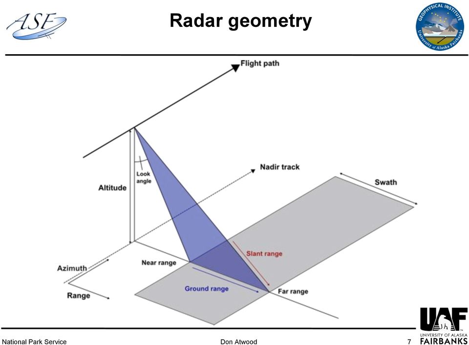
7 Radar geometry 7
8 Forming a Synthetic Aperture Pixel constructed from N pulses X Ground Swath Length of Synthetic Aperture Flight Path 8

9 SAR Scattering Mechanisms Surface Scattering 9

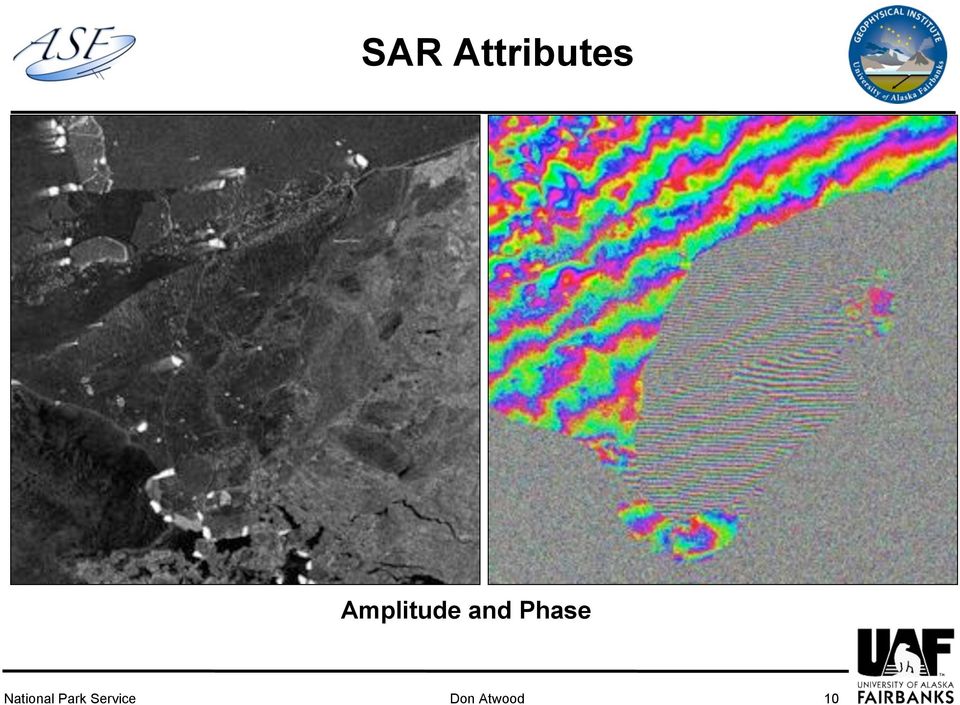
10 SAR Attributes Amplitude and Phase 10
11 Coherence 11

12 Radar wavelengths (3.2 cm) (5.7 cm) (23.0 cm) 12
 (23.")
13 Radar Polarization Horizontal Transmit Horizontal Receive HH HV Horizontal Transmit Vertical Receive VV VH Vertical Transmit Vertical Receive Vertical Transmit Horizontal Receive 13

14 Applications 14
15 Urban Change JERS-1 - Oct 1997 ALOS PALSAR - Oct

16 Urban Change ALOS PALSAR (R,B) and JERS (G) with Road Shapefile Overlay 16

17 Volcanic Eruption Detection R, B: July 2007 G: July 2008 Mt. Cleveland 17

18 Coastal Erosion 1955 USGS Map 1:63,360 18

19 Coastal Erosion USGS Map 1:63,360 19

20 Coastal Erosion 1955 to 1998 JERS-1 vs. USGS Map 1:63,360 20

21 Flood Detection Dual Polarization R,B: HH G: HV 21
22 Hydrology Delineation Amplitude Image Coherence Image Classified Image 22
23 Glacier Delineation Since glacier outlines are optically determined, classification is extremely difficult for debris-covered glaciers. They look like dirt McCarthy, Alaska Optical delineation can be difficult 23
24 Kennicott: Optical Image 24
25 Kennicott: Coherence Plot 25
26 Burn Scar Detection 26
27 Accessing SAR Data 27
28 Alaska Satellite Facility (ASF) Operated by the Geophysical Institute (University of Alaska Fairbanks) Member of the NASA DAAC Alliance ASF operates on a 24x7 schedule 50,000 image products per year U.S. Order Desk for customers of ERS-2 Americas Data Node for customers of ALOS 28
29 ASF Receiving Ground Station ASF operates two, X-band receiving antennas 11m Antenna Currently downlinking two SAR satellites: ERS-2 ALOS 10m Antenna 29
30 R % J % ASF Archive Data E1 15% E2 10% ASF Archive contains: 400 TB of SAR data 30
31 Accessing SAR Data Step 1: Submit a short proposal describing research and data requirements. Proposal must be approved by NASA or government consortium (NASA/USGS/NSF). Step 2: Access SAR data through ASF s URSA user interface. Archive Data: Extensive archive of ERS-1, ERS-2, JERS-1, RADARSAT-1and ALOS PALSAR data exists at ASF. Accessed through the User Remote Sensing Access (URSA). New SAR Data: New acquisitions of ALOS PALSAR and ERS-2. Complete a Data Acquisition Request (DAR) for future satellite tasking. Access data once in the ASF Archive. Visit 31
32 Don Atwood Alaska Satellite Facility Questions? 32
Satellites for Terrain Motion Mapping Terrafirma User Workshop Mining. Nico Adam
 Satellites for Terrain Motion Mapping Terrafirma User Workshop Mining Nico Adam Outline SAR / InSAR observation characteristic Sensors TSX, TDX ERS-1, ERS-2 Processing techniques D-InSAR PSI SBAS Acquisition
Radar interferometric techniques and data validation Terrafirma Essen, March 2011. Page 1
 Radar interferometric techniques and data validation Terrafirma Essen, March 2011 Page 1 Agenda Introduction to InSAR technology Different radarinterferometric techniques Validation of InSAR technology
Two primary advantages of radars: all-weather and day /night imaging
 Lecture 0 Principles of active remote sensing: Radars. Objectives: 1. Radar basics. Main types of radars.. Basic antenna parameters. Required reading: G: 8.1, p.401-40 dditional/advanced reading: Online
Monitoring Soil Moisture from Space. Dr. Heather McNairn Science and Technology Branch Agriculture and Agri-Food Canada heather.mcnairn@agr.gc.
 Monitoring Soil Moisture from Space Dr. Heather McNairn Science and Technology Branch Agriculture and Agri-Food Canada heather.mcnairn@agr.gc.ca What is Remote Sensing? Scientists turn the raw data collected
SARscape 4.3 Supported Sensors/Products (March 2011) - Spaceborne Sensors -
 - Spaceborne Sensors -") SARscape 4.3 Supported Sensors/Products (March 2011) - Spaceborne Sensors - ALOS PALSAR (provided by JAXA) In case of RAW (level 1.0) data, import is carried out within the Focusing Module. PALSAR RAW
SARscape 4.3 Supported Sensors/Products (March 2011) - Spaceborne Sensors - ALOS PALSAR (provided by JAXA) In case of RAW (level 1.0) data, import is carried out within the Focusing Module. PALSAR RAW
Active and Passive Microwave Remote Sensing
 Active and Passive Microwave Remote Sensing Passive remote sensing system record EMR that was reflected (e.g., blue, green, red, and near IR) or emitted (e.g., thermal IR) from the surface of the Earth.
The most widely used active remote sensing systems include:
 Active and Passive Remote Sensing Passive remote sensing systems record EMR that is reflected (e.g., blue, green, red, and near-infrared light) or emitted (e.g., thermal infrared energy) from the surface
National Snow and Ice Data Center
 National Snow and Ice Data Center This data set (NSIDC-0484), part of the NASA Making Earth System Data Records for Use in Research Environments (MEaSUREs) Program, provides the first comprehensive, high-resolution,
SAR Measurements of Wind Field, Sea State Topography at Offshore Platforms
 SAR Measurements of Wind Field, Sea State Topography at Offshore Platforms Susanne Lehner DLR, Oberpfaffenhofen Susanne.Lehner@dlr.de Planned NRT Products ENVISAT Wind Sea State OIl Land-Water Line Ships
Remote Sensing Satellite Information Sheets Geophysical Institute University of Alaska Fairbanks
 Remote Sensing Satellite Information Sheets Geophysical Institute University of Alaska Fairbanks ASTER Advanced Spaceborne Thermal Emission and Reflection Radiometer AVHRR Advanced Very High Resolution
Monitoring of Arctic Conditions from a Virtual Constellation of Synthetic Aperture Radar Satellites
 DISTRIBUTION STATEMENT A. Approved for public release; distribution is unlimited. Monitoring of Arctic Conditions from a Virtual Constellation of Synthetic Aperture Radar Satellites Hans C. Graber RSMAS
How To Write A Call To Action For Terrasar-X
 Doc.: TX-PGS-PL-4127 TerraSAR-X Announcement of Opportunity: Utilization of the TerraSAR-X Archive 1 Page: 2 of 11 TABLE OF CONTENTS TERRASAR-X... 1 ANNOUNCEMENT OF OPPORTUNITY: UTILIZATION OF THE TERRASAR-X
Brian D. Conway Hydrologist/Supervisor Geophysics-Surveying Unit
 Arizona Department of Water Resources Land Subsidence Monitoring Program Using Interferometric Synthetic Aperture Radar (InSAR) in Cochise County, Southeastern Arizona Brian D. Conway Hydrologist/Supervisor
Earth remote sensing systems of middle and low resolution
 Earth remote sensing systems of middle and low resolution Serial on-line remote sensing satellites delivering data available on the world market V.I. Gershenzon (ScanEx R&D Center) In 1980, graduated from
A tiered reconnaissance approach toward flood monitoring utilising multi-source radar and optical data
 5 th International Workshop on Remote Sensing for Disaster Response A tiered reconnaissance approach toward flood monitoring utilising multi-source radar and optical data Anneley McMillan Dr. Beverley
DIFFERENTIAL INSAR MONITORING OF THE LAMPUR SIDOARJO MUD VOLCANO (JAVA, INDONESIA) USING ALOS PALSAR IMAGERY
 USING ALOS PALSAR IMAGERY") DIFFERENTIAL INSAR MONITORING OF THE LAMPUR SIDOARJO MUD VOLCANO (JAVA, INDONESIA) USING ALOS PALSAR IMAGERY Adam Thomas (1), Rachel Holley (1), Richard Burren (1), Chris Meikle (2), David Shilston (2)
DIFFERENTIAL INSAR MONITORING OF THE LAMPUR SIDOARJO MUD VOLCANO (JAVA, INDONESIA) USING ALOS PALSAR IMAGERY Adam Thomas (1), Rachel Holley (1), Richard Burren (1), Chris Meikle (2), David Shilston (2)
Review for Introduction to Remote Sensing: Science Concepts and Technology
 Review for Introduction to Remote Sensing: Science Concepts and Technology Ann Johnson Associate Director ann@baremt.com Funded by National Science Foundation Advanced Technological Education program [DUE
POTENTIALS OF HIGH RESOLUTION TERRASAR-X IMAGES IN INSAR PROCESSING
 POTENTIALS OF HIGH RESOLUTION TERRASAR-X IMAGES IN INSAR PROCESSING FOR EARTH DEFORMATION AND ENVIRONMENTAL STUDIES Magdalena Niemiec 1 Abstract Accurate determination of topography and surface deformation
Monitoring of Arctic Conditions from a Virtual Constellation of Synthetic Aperture Radar Satellites
 DISTRIBUTION STATEMENT A. Approved for public release; distribution is unlimited. Monitoring of Arctic Conditions from a Virtual Constellation of Synthetic Aperture Radar Satellites Hans C. Graber RSMAS
Passive remote sensing systems record electromagnetic energy that was reflected (e.g., blue, green, red, and near-infrared light) or emitted (e.g.
 or emitted (e.g.") CHAPTER 9: Active and Passive Microwave RS REFERENCE: Remote Sensing of the Environment John R. Jensen (2007) Second Edition Pearson Prentice Hall Passive Remote Sensing Passive remote sensing systems
CHAPTER 9: Active and Passive Microwave RS REFERENCE: Remote Sensing of the Environment John R. Jensen (2007) Second Edition Pearson Prentice Hall Passive Remote Sensing Passive remote sensing systems
Professional SAR Data Processing
 Professional SAR Data Processing SAR Tutorial at EUSAR 2012 in Nürnberg (Germany) Dr. Thomas Bahr The information contained in this document pertains to software products and services that are subject
The use of Satellite Remote Sensing for Offshore Environmental Benchmarking
 The use of Satellite Remote Sensing for Offshore Environmental Benchmarking Michael King Fugro NPA Limited Fugro NPA (Formerly Nigel Press Associates) World leading Satellite Remote Sensing & Geoscience
Comparison of ALOS-PALSAR and TerraSAR-X Data in terms of Detecting Settlements First Results
 ALOS 2008 Symposium, 3-7 November Rhodes, Greece Comparison of ALOS-PALSAR and TerraSAR-X Data in terms of Detecting Settlements First Results Thomas Esch*, Achim Roth*, Michael Thiel, Michael Schmidt*,
Operational Space- Based Crop Mapping Protocols at AAFC A. Davidson, H. McNairn and T. Fisette.
 Operational Space- Based Crop Mapping Protocols at AAFC A. Davidson, H. McNairn and T. Fisette. Science & Technology Branch. Agriculture and Agri-Food Canada. 1. Introduction Space-Based Crop Mapping at
Exploitation of historical satellite SAR archives for mapping and monitoring landslides at regional and local scale
 Exploitation of historical satellite SAR archives for mapping and monitoring landslides at regional and local scale (A. Ferretti (TRE), A. Tamburini (TRE), M. Bianchi (TRE), M. Broccolato (Regione Valle
A remote sensing instrument collects information about an object or phenomenon within the
 Satellite Remote Sensing GE 4150- Natural Hazards Some slides taken from Ann Maclean: Introduction to Digital Image Processing Remote Sensing the art, science, and technology of obtaining reliable information
Sentinel-1 Mission Overview
 Sentinel-1 Mission Overview Pierre Potin Sentinel-1 Mission Manager, ESA Advanced Course on Radar Polarimetry ESRIN, Frascati, 19 January 2011 Global Monitoring for Environment and Security GMES is established
Введение в спутниковую радиолокацию: Радиолокаторы с синтезированной апертурой (РСА) Introduction to satellite radars: Synthetic Aperture Radars (SAR)
 Introduction to satellite radars: Synthetic Aperture Radars (SAR)") Введение в спутниковую радиолокацию: Радиолокаторы с синтезированной апертурой (РСА) Introduction to satellite radars: Synthetic Aperture Radars (SAR) проф. Бертран Шапрон IFREMER / ЛСО РГГМУ Prof. Bertrand
Введение в спутниковую радиолокацию: Радиолокаторы с синтезированной апертурой (РСА) Introduction to satellite radars: Synthetic Aperture Radars (SAR) проф. Бертран Шапрон IFREMER / ЛСО РГГМУ Prof. Bertrand
The DLR Multi Mission EO Ground Segment
 The DLR Multi Mission EO Ground Segment Payload Ground Segment Erhard Diedrich Remote Sensing Workshop Mexico 22-24 April 2008 DLR Ground Segment for Earth Observation: Servicing GMES, national and commercial
TerraSAR-X Image Product Guide. Basic and Enhanced Radar Satellite Imagery. Airbus Defence and Space Geo-Intelligence Programme Line
 TerraSAR-X Image Product Guide Geo-Intelligence Programme Line 1 Introduction TerraSAR-X and TanDEM-X are commercial German Synthetic Aperture Radar (SAR) Earth observation satellites, which were launched
Let s SAR: Mapping and monitoring of land cover change with ALOS/ALOS-2 L-band data
 Let s SAR: Mapping and monitoring of land cover change with ALOS/ALOS-2 L-band data Rajesh Bahadur THAPA, Masanobu SHIMADA, Takeshi MOTOHKA, Manabu WATANABE and Shinichi rajesh.thapa@jaxa.jp; thaparb@gmail.com
Integration between spaceand ground-based data sets: application on ground deformations measurements
 Integration between spaceand ground-based data sets: application on ground deformations measurements Giuseppe Puglisi Istituto Nazionale di Geofisica e Vulcanologia Sezione di Catania Osservatorio Etneo
TerraSAR-X Interferometry. Michael Eineder, Nico Adam Remote Sensing Technology Institute
 TerraSAR-X Interferometry Michael Eineder, Nico Adam Remote Sensing Technology Institute TerraSAR-X Contribution to Commissioning Phase: verify phase and geometric stability of instrument and SAR processor
Determination of Flood Extent Using Remote Sensing
 Determination of Flood Extent Using Remote Sensing A Term Paper Submitted to Dr. Benoit Rivard Professor Department of Earth and Atmospheric Science University of Alberta Source: Dartmouth Flood observatory
Information Contents of High Resolution Satellite Images
 Information Contents of High Resolution Satellite Images H. Topan, G. Büyüksalih Zonguldak Karelmas University K. Jacobsen University of Hannover, Germany Keywords: satellite images, mapping, resolution,
Remote Sensing Applications in Support of Sustainable Development and Disaster Management by DLR Current Activities
 Remote Sensing Applications in Support of Sustainable Development and Disaster Management by DLR Current Activities Dr. Günter Strunz German Aerospace Center (DLR) German Remote Sensing Data Center 43rd
Monitoring and characterizing natural hazards with satellite InSAR imagery
 Annals of GIS Vol. 16, No. 1, March 2010, 55 66 Monitoring and characterizing natural hazards with satellite InSAR imagery Zhong Lu a *, Jixian Zhang b, Yonghong Zhang b and Daniel Dzurisin a a US Geological
COSMO-SKYMED SATELLITES FOR SCIENTIFIC RESEARCH AND DISASTER MONITORING
 Hans C. Graber Executive Director Center for Southeastern Tropical Advanced Remote Sensing Division of Applied Marine Physics Rosenstiel School of Marine & Atmospheric Science University of Miami COSMO-SKYMED
Development of Web Services Infrastructure for Enhanced Access to Synthetic Aperture Radar (SAR) Data from Satellite and Airborne Sensors
 Data from Satellite and Airborne Sensors") Development of Web Services Infrastructure for Enhanced Access to Synthetic Aperture Radar (SAR) Data from Satellite and Airborne Sensors A Proposal to the NASA ROSES-08 Advanced Information Systems Technology
Development of Web Services Infrastructure for Enhanced Access to Synthetic Aperture Radar (SAR) Data from Satellite and Airborne Sensors A Proposal to the NASA ROSES-08 Advanced Information Systems Technology
Matsu: An Elastic Cloud Connected to a SensorWeb for Disaster. (Session 12F Working Group: Cloud Computing for Spacecraft Operations)
") Matsu: An Elastic Cloud Connected to a SensorWeb for Disaster Response (Session 12F Working Group: Cloud Computing for Spacecraft Operations) Daniel Mandl - NASA/GSFC 3/2/11 1 SensorWeb High Level Architecture
Matsu: An Elastic Cloud Connected to a SensorWeb for Disaster Response (Session 12F Working Group: Cloud Computing for Spacecraft Operations) Daniel Mandl - NASA/GSFC 3/2/11 1 SensorWeb High Level Architecture
HIGH RESOLUTION MONITORING OF CAMPI FLEGREI (NAPLES, ITALY) BY EXPLOITING TERRASAR-X DATA: AN APPLICATION TO SOLFATARA CRATER
 BY EXPLOITING TERRASAR-X DATA: AN APPLICATION TO SOLFATARA CRATER") HIGH RESOLUTION MONITORING OF CAMPI FLEGREI (NAPLES, ITALY) BY EXPLOITING TERRASAR-X DATA: AN APPLICATION TO SOLFATARA CRATER Christian Minet (1), Kanika Goel (1), Ida Aquino (2), Rosario Avino (2), Giovanna
HIGH RESOLUTION MONITORING OF CAMPI FLEGREI (NAPLES, ITALY) BY EXPLOITING TERRASAR-X DATA: AN APPLICATION TO SOLFATARA CRATER Christian Minet (1), Kanika Goel (1), Ida Aquino (2), Rosario Avino (2), Giovanna
Monitoring of Arctic Conditions from a Virtual Constellation of Synthetic Aperture Radar Satellites
 DISTRIBUTION STATEMENT A. Approved for public release; distribution is unlimited. Monitoring of Arctic Conditions from a Virtual Constellation of Synthetic Aperture Radar Satellites RSMAS Department of
TerraSAR X and TanDEM X satellite missions update & other activities Dana Floricioiu German Aerospace Center (DLR), Remote Sensing Technology
, Remote Sensing Technology") TerraSAR X and TanDEM X satellite missions update & other activities Dana Floricioiu German Aerospace Center (DLR), Remote Sensing Technology Institute, Oberpfaffenhofen, Germany PSTG 2 12 14 June 2012
TerraSAR X and TanDEM X satellite missions update & other activities Dana Floricioiu German Aerospace Center (DLR), Remote Sensing Technology Institute, Oberpfaffenhofen, Germany PSTG 2 12 14 June 2012
COASTAL WIND ANALYSIS BASED ON ACTIVE RADAR IN QINGDAO FOR OLYMPIC SAILING EVENT
 COASTAL WIND ANALYSIS BASED ON ACTIVE RADAR IN QINGDAO FOR OLYMPIC SAILING EVENT XIAOMING LI a, b, * a Remote Sensing Technology Institute, German Aerospace Center (DLR), Oberpfaffenhofen, 82234, Germany
The European Space Agency s Synthetic Aperture Radar Programme From Experiment to Service Provision
 The European Space Agency s Synthetic Aperture Radar Programme From Experiment to Service Provision Evert Attema ESA, Directorate of Earth Observation Programme! The idea of an independent European space
Real Time Services for Space Applications Holger Maass, Susanne Lehner
 Real Time Services for Space Applications Holger Maass, Susanne Lehner Holger.Maass@dlr.de German Remote Sensing Data Center ( DFD ) with 2 locations in Germany Neustrelitz in Mecklenburg-Vorpommern Oberpfaffenhofen
CEOS contribution to the GEO Geohazard Supersite and Natural Laboratories Initiative Data access and license conditions
 CEOS contribution to the GEO Geohazard Supersite and Natural Laboratories Initiative Data access and license conditions Ecuadorian Volcanoes Permanent Supersite December 8, 2014 1. Purpose and Scope This
NASA Earth System Science: Structure and data centers
 SUPPLEMENT MATERIALS NASA Earth System Science: Structure and data centers NASA http://nasa.gov/ NASA Mission Directorates Aeronautics Research Exploration Systems Science http://nasascience.nasa.gov/
Synthetic Aperture Radar: Principles and Applications of AI in Automatic Target Recognition
 Synthetic Aperture Radar: Principles and Applications of AI in Automatic Target Recognition Paulo Marques 1 Instituto Superior de Engenharia de Lisboa / Instituto de Telecomunicações R. Conselheiro Emídio
COASTAL FLOOD INUNDATION MONITORING WITH SATELLITE C-BAND AND L-BAND SYNTHETIC APERTURE RADAR DATA 1
 AMERICAN WATER RESOURCES ASSOCIATION COASTAL FLOOD INUNDATION MONITORING WITH SATELLITE C-BAND AND L-BAND SYNTHETIC APERTURE RADAR DATA 1 Elijah Ramsey III, Amina Rangoonwala, and Terri Bannister 2 ABSTRACT:
Chapter 1. Principles of Synthetic Aperture Radar
 Chapter 1. Principles of Synthetic Aperture Radar Samuel W. (Walt) McCandless, Jr. SEASAT Program Manager User Systems Enterprises, Inc., Denver, CO, USA Christopher R. Jackson Radar Imaging Resources,
Istanbul Technical University-Center for Satellite Communications and Remote Sensing (ITU-CSCRS)
") Istanbul Technical University-Center for Satellite Communications and Remote Sensing (ITU-CSCRS) Istanbul Technical University, Center for Satellite Communications and Remote Sensing (ITU-CSCRS) was originally
Istanbul Technical University-Center for Satellite Communications and Remote Sensing (ITU-CSCRS) Istanbul Technical University, Center for Satellite Communications and Remote Sensing (ITU-CSCRS) was originally
Synthetic Aperture Radar (SAR) Imaging using the MIT IAP 2011 Laptop Based Radar*
 Imaging using the MIT IAP 2011 Laptop Based Radar*") Synthetic Aperture Radar (SAR) Imaging using the MIT IAP 2011 Laptop Based Radar* Presented at the 2011 MIT Independent Activities Period (IAP) Gregory L. Charvat, PhD 24 January 2011 *This work is sponsored
Synthetic Aperture Radar (SAR) Imaging using the MIT IAP 2011 Laptop Based Radar* Presented at the 2011 MIT Independent Activities Period (IAP) Gregory L. Charvat, PhD 24 January 2011 *This work is sponsored
Orbital and atmospheric noise in InSAR data inferred from the global ERS1,2 and Envisat SAR data archives
 Category-1 proposal submitted to the European Space Agency Orbital and atmospheric noise in InSAR data inferred from the global ERS1,2 and Envisat SAR data archives Executive Summary We request the online
SAR Archive and Community Support Activities at UNAVCO
 SAR Archive and Community Support Activities at UNAVCO Scott Baker 1, Chris Crosby 1, Charles Meertens 1, Eric Fielding 2, Gwen Bryson 3, Brian Buechler 3, Jeremy Nicoll 3, Chaitanya Baru 4 1 UNAVCO, Boulder,
Multisensor Data Integration in O&G Business Lutz Petrat Hélène Lemonnier Michael Hall
 Multisensor Data in O&G Business Lutz Petrat Hélène Lemonnier Michael Hall ESA Oil and Gas Workshop 15/09/2010, Frascati, Italy Satellite Products and Services during a typical O&G project Project Life
Persistent Scatterer Interferometry and Cosmo-SkyMed data in the Piano Straordianario di Telerilevamento Ambientale (PST-A) Salvatore Costabile
 Salvatore Costabile") Persistent Scatterer Interferometry and Cosmo-SkyMed data in the Piano Straordianario di Telerilevamento Ambientale (PST-A) Salvatore Costabile E-GEOS Conference 2012 23-24 May, Rome (Italy) Summary PST-A:
Persistent Scatterer Interferometry and Cosmo-SkyMed data in the Piano Straordianario di Telerilevamento Ambientale (PST-A) Salvatore Costabile E-GEOS Conference 2012 23-24 May, Rome (Italy) Summary PST-A:
Microwaves and Radar Institute
 Microwaves and Radar Institute Research and Projects Alberto Moreira German Aerospace Center DLR Oberpfaffenhofen, Germany Microwaves and Radar Institute 30+ years of experience in SAR systems and applications
Remote sensing and SAR radar images processing Physics of radar
 Remote sensing and SAR radar images processing Physics of radar TABLE OF CONTENTS Potentialities of radar Radar transmission features Propagation of radio waves Radar equation Surface scattering mechanisms
Advantages and limitations of using satellite images for flood mapping
 Advantages and limitations of using satellite images for flood mapping Domenico Grandoni e-geos Headquarter Contrada Terlecchie 75100 Matera - Italy Commercial Office Via Cannizzaro 71 00156 Roma - Italy
High Resolution 3D Earth Observation Data Analysis for Safeguards Activities
 High Resolution 3D Earth Observation Data Analysis for Safeguards Activities Pablo d'angelo a1, Cristian Rossi a, Christian Minet a, Michael Eineder a, Michael Flory b, Irmgard Niemeyer c a German Aerospace
Satellite'&'NASA'Data'Intro'
 Satellite'&'NASA'Data'Intro' Research'vs.'Opera8ons' NASA':'Research'satellites' ' ' NOAA/DoD:'Opera8onal'Satellites' NOAA'Polar'Program:'NOAA>16,17,18,19,NPP' Geosta8onary:'GOES>east,'GOES>West' DMSP'series:'SSM/I,'SSMIS'
The Application of Synthetic Aperture Radar (SAR) to Natural Resource Damage Assessment
 to Natural Resource Damage Assessment") The Application of Synthetic Aperture Radar (SAR) to Natural Resource Damage Assessment George Graettinger, GIS Project Manager Jay Coady, Nicolas Eckhardt, Mathew Dorsey, and Paul Whelan NOAA s Ocean
The Application of Synthetic Aperture Radar (SAR) to Natural Resource Damage Assessment George Graettinger, GIS Project Manager Jay Coady, Nicolas Eckhardt, Mathew Dorsey, and Paul Whelan NOAA s Ocean
MONITORING TROPICAL FORESTS USING SYNTHETIC APERTURE RADAR
 The Balance between Biodiversity Conservation and Sustainable Use of Tropical Rain Forests MONITORING TROPICAL FORESTS USING SYNTHETIC APERTURE RADAR Dirk H. Hoekman ABSTRACT Advanced Synthetic Aperture
TerraSAR-X Applications Guide
 TerraSAR-X Applications Guide Extract: Maritime Monitoring: Oil Spill Detection April 2015 Airbus Defence and Space Geo-Intelligence Programme Line Maritime Monitoring: Oil Spill Detection Issue As the
Research on Soil Moisture and Evapotranspiration using Remote Sensing
 Research on Soil Moisture and Evapotranspiration using Remote Sensing Prof. dr. hab Katarzyna Dabrowska Zielinska Remote Sensing Center Institute of Geodesy and Cartography 00-950 Warszawa Jasna 2/4 Field
Geological hazards and monitoring activities at the Azores archipelago
 Geological hazards and monitoring activities at the Azores archipelago Teresa Ferreira (1,2), João Gaspar (1,2), Gabriela Queiroz (1,2) (1) CVARG (Centre for Volcanology and Geological Risks Assessment)
Chapter Contents Page No
 Chapter Contents Page No Preface Acknowledgement 1 Basics of Remote Sensing 1 1.1. Introduction 1 1.2. Definition of Remote Sensing 1 1.3. Principles of Remote Sensing 1 1.4. Various Stages in Remote Sensing
Using advanced InSAR techniques as a remote tool for mine site monitoring
 The Southern African Institute of Mining and Metallurgy Slope Stability 2015 D. Colombo and B. MacDonald Using advanced InSAR techniques as a remote tool for mine site monitoring D. Colombo* and B. MacDonald
DESCW: PC Software Supporting Remote Sensing Data
 r bulletin 97 march 1999 DESCW: PC Software Supporting Remote Sensing Data S. D Elia Earth Remote Sensing Exploitation Division, ESA Directorate for Application Programmes, ESRIN, Frascati, Italy R. Biasutti
Radar Interferometric and Polarimetric Possibilities for Determining Sea Ice Thickness
 Radar Interferometric and Polarimetric Possibilities for Determining Sea Ice Thickness by Scott Hensley, Ben Holt, Sermsak Jaruwatanadilok, Jeff Steward, Shadi Oveisgharan Delwyn Moller, Jim Reis, Andy
APPLICATION OF SATELLITE DATA FOR IMPROVED FLOOD FORECASTING AND MAPPING
 4 th International Symposium on Flood Defence: Managing Flood Risk, Reliability and Vulnerability Toronto, Ontario, Canada, May 6-8, 2008 APPLICATION OF SATELLITE DATA FOR IMPROVED FLOOD FORECASTING AND
Software Architecture Document (SAD) for the Interferometric Modules of the Next ESA SAR Toolbox (NEST)
 for the Interferometric Modules of the Next ESA SAR Toolbox (NEST)") Software Architecture Document (SAD) for the Interferometric Modules of the Next ESA SAR Toolbox (NEST) Contract number: 20809/07/I-LG Prepared by: PPO.labs Prepared for: The European Space Agency Revision
Software Architecture Document (SAD) for the Interferometric Modules of the Next ESA SAR Toolbox (NEST) Contract number: 20809/07/I-LG Prepared by: PPO.labs Prepared for: The European Space Agency Revision
TerraSAR-X capabilities and constrains for acquisitions over the polar regions. Dana Floricioiu
 TerraSAR-X capabilities and constrains for acquisitions over the polar regions Dana Floricioiu STG IPY SAR Workshop Montreal 5/6 March 2008 TerraSAR-X Features Multi-Mode Imaging StripMap (High-Resolution)
Signal Processing for Synthetic Aperture Radars
 IWSSIP 1-17th International Conference on Systems, Signals and Image Processing Signal Processing for Synthetic Aperture Radars Žarko Čučej Uniersity of Maribor, Faculty of Electrical Engineering and Computer
Geography 403 Lecture 7 Scanners, Thermal, and Microwave
 Geography 403 Lecture 7 Scanners, Thermal, and Microwave Needs: Lect_403_7.ppt A. Basics of Passive Electric Sensors 1. Sensors absorb EMR and produce some sort of response, such as voltages differences
Satellite Altimetry Missions
 Satellite Altimetry Missions SINGAPORE SPACE SYMPOSIUM 30 TH SEPTEMBER 2015 AUTHORS: LUCA SIMONINI/ ERICK LANSARD/ JOSE M GONZALEZ www.thalesgroup.com Table of Content General Principles and Applications
Evaluating GCM clouds using instrument simulators
 Evaluating GCM clouds using instrument simulators University of Washington September 24, 2009 Why do we care about evaluation of clouds in GCMs? General Circulation Models (GCMs) project future climate
Cluster Applied Remote Sensing TerraSAR-X Ground Segment Basic Product Specification Document. Ground Segment. Basic Product Specif ication Document
 Page: 1 of 108 Ground Segment Basic Product Specif ication Document CAF - Cluster Applied Remote Sensing editors: 30.3.2009 T. Fritz, M. Eineder Date SAR ~rbduct Verification Responsible & TMSP Team reviewed:
How To Find Natural Oil Seepage In The Dreki Area Using An Envisat Image
 rn ORKUSTOFNUN National Energy Authority Searching for natural oil seepage in the Dreki area using ENVISAT radar images. Ingibjorg J6nsd6ttir and Arni Freyr Valdimarsson, Faculty of Earth Sciences School
Data Collection via Synthetic Aperture Radiometry towards Global System
 RESEARCH ARTICLE OPEN ACCESS Data Collection via Synthetic Aperture Radiometry towards Global System Ali. A. J.Al-Sabbagh**, Ruaa.A.S.Alsabah***, Josko.Zec*, Ivica Kostanic* *Department of Electrical and
Prediction of Storm Surge using Space Data. Susanne Lehner German Aerospace Center
 Prediction of Storm Surge using Space Data Susanne Lehner German Aerospace Center Existing Crisis Information State of the Art of Satellite Crisis Information (ZKI) Mapping after the storm www.zki.de
How To Monitor Sea Level With Satellite Radar
 Satellite Altimetry Wolfgang Bosch Deutsches Geodätisches Forschungsinstitut (DGFI), München email: bosch@dgfi.badw.de Objectives You shall recognize satellite altimetry as an operational remote sensing
LANDSAT 7 - GROUND SEGMENT ACTIVITIES AT THE GERMAN REMOTE SENSING DATA CENTER. Deutsches Fernerkundungsdatenzentrum (DFD) DLR (*)
 DLR (*)") LANDSAT 7 - GROUND SEGMENT ACTIVITIES AT THE GERMAN REMOTE SENSING DATA CENTER Günter Strunz (*), Hans-Dietrich Bettac (**), Jörg Gredel (*), Klaus-Dieter Reiniger (*) & Gunter Schreier (*) Deutsches Fernerkundungsdatenzentrum
LANDSAT 7 - GROUND SEGMENT ACTIVITIES AT THE GERMAN REMOTE SENSING DATA CENTER Günter Strunz (*), Hans-Dietrich Bettac (**), Jörg Gredel (*), Klaus-Dieter Reiniger (*) & Gunter Schreier (*) Deutsches Fernerkundungsdatenzentrum
16 th IOCCG Committee annual meeting. Plymouth, UK 15 17 February 2011. mission: Present status and near future
 16 th IOCCG Committee annual meeting Plymouth, UK 15 17 February 2011 The Meteor 3M Mt satellite mission: Present status and near future plans MISSION AIMS Satellites of the series METEOR M M are purposed
GPS Precise Point Positioning as a Method to Evaluate Global TanDEM-X Digital Elevation Model
 GPS Precise Point Positioning as a Method to Evaluate Global TanDEM-X Digital Elevation Model 7 th FIG Regional Conference TS 1C Advances in GNSS Positioning and Applications I Volker Schwieger 1, Jürgen
Wind Field Observations with a Monostatic and Bistatic C-band Doppler Radar Network
 Wind Field Observations with a Monostatic and Bistatic C-band Doppler Radar Network Martin Hagen, DLR Oberpfaffenhofen Wind field and Doppler radar Doppler radar (and lidar) can only measure one component
German Aerospace Center A member of the Helmholtz Association. Microwaves and Radar Institute. Digital- & Offsetdruck Wolfertstetter KG, Gilching
 Institute s Brochure Microwaves and Radar Institute Overview of Projects and Research Activities 1 German Aerospace Center A member of the Helmholtz Association Microwaves and Radar Institute Director
Deutsches Fernerkundungsdatenzentrum Nationales Bodensegment Neustrelitz. Holger Maass. Storagetechnology 2008 4.-6. Juni 2008, Fleesensee
 Deutsches Fernerkundungsdatenzentrum Nationales Bodensegment Neustrelitz Holger Maass Storagetechnology 2008 4.-6. Juni 2008, Fleesensee German Remote Sensing Data Center ( DFD ) with 2 locations in Germany
Applications and Analyses of Satellite-borne L-band Synthetic Aperture Radar Data in Coastal Environments
 Geography Compass 3/4 (2009): 1465 1482, 10.1111/j.1749-8198.2009.00254.x Applications and Analyses of Satellite-borne L-band Synthetic Aperture Radar Data in Coastal Environments Yong Wang 1 *, Mingsheng
European Space Agency EO Missions. Ola Gråbak ESA Earth Observation Programmes Tromsø, 17 October 2012
 European Space Agency EO Missions Ola Gråbak ESA Earth Observation Programmes Tromsø, 17 October 2012 Europe and Space, A POLICY Article 189 of the Lisbon Treaty (2009) gives the European Union an explicit
Image courtesy of the Canadian Center for Remote Sensing
 ADWR s Land Subsidence Monitoring Program Interferometric Synthetic Aperture Radar (InSAR) Brian D. Conway Hydrology Division Geophysics/Surveying Unit Image courtesy of the Canadian Center for Remote
Remote Sensing an Introduction
 Remote Sensing an Introduction Seminar: Space is the Place Referenten: Anica Huck & Michael Schlund Remote Sensing means the observation of, or gathering information about, a target by a device separated
Reviewing ALOS PALSAR Backscatter Observations for Stem Volume Retrieval in Swedish Forest
 Remote Sens. 2015, 7, 4290-4317; doi:10.3390/rs70404290 Article OPEN ACCESS remote sensing ISSN 2072-4292 www.mdpi.com/journal/remotesensing Reviewing ALOS PALSAR Backscatter Observations for Stem Volume
Joint Polar Satellite System (JPSS)
") Joint Polar Satellite System (JPSS) John Furgerson, User Liaison Joint Polar Satellite System National Environmental Satellite, Data, and Information Service National Oceanic and Atmospheric Administration
Joint Polar Satellite System (JPSS) John Furgerson, User Liaison Joint Polar Satellite System National Environmental Satellite, Data, and Information Service National Oceanic and Atmospheric Administration
High Resolution Information from Seven Years of ASTER Data
 High Resolution Information from Seven Years of ASTER Data Anna Colvin Michigan Technological University Department of Geological and Mining Engineering and Sciences Outline Part I ASTER mission Terra
Developments toward a European Land Monitoring Framework. Geoff Smith. Seminar 2 nd December, 2015 Department of Geography, University of Cambridge
 Developments toward a European Land Monitoring Framework Geoff Smith Specto Natura Limited Enable clients to deliver useful, accurate and reliable environmental information from EO. Positioned at the interface
Satellite Snow Monitoring Activities Project CRYOLAND
 Satellite Snow Monitoring Activities Project CRYOLAND Background material for participants to the Workshop on European Snow Monitoring Perspectives, Darmstadt, 4-5 December 2012. CryoLand provides Snow,
Monitoring the forest using the ALOS. M. Shimada JAXA/EORC. Feb. 5 2009
 Monitoring the forest using the ALOS M. Shimada JAXA/EORC Feb. 5 2009 The Advanced Land Observation Satellite - ALOS PALSAR L-band (23.6 cm) Synthetic Aperture Radar Polarimetry Dual Polarization SCANSAR
Remote sensing is the collection of data without directly measuring the object it relies on the
 Chapter 8 Remote Sensing Chapter Overview Remote sensing is the collection of data without directly measuring the object it relies on the reflectance of natural or emitted electromagnetic radiation (EMR).