Using Location Information For Better Planning and Decision Support: Integrating Big Data, Official Statistics, Geo-information
|
|
|
- Ann Flowers
- 8 years ago
- Views:
Transcription
1 Using Location Information For Better Planning and Decision Support: Integrating Big Data, Official Statistics, Geo-information

2 Rapid Information for Public Policy Increasing demand for information in public policy; Users want quick data and rapid assessment. Traditional sources (surveys) less emphasized. Too time consuming. Too slow; Statistical community adjusting using multi-mode approach: internet, call center, fax, sms, sensors; Increasing use of administrative data; Realizing back-end system integration important;

3 Data Fusion as a New Challenge Data Fusion as a new Data Paradigm Data fusion occurs when data from different sources are brought into contact and new facts emerge. Individually, each data source may have a specific limited purpose. Their combination, however, may uncover new meanings Policy attention should focus on Actual Uses of Big Data, and less on its collection and analysis 1 May, White House

4 UNSD has been taking the lead in this initiative; 2009 Initiation of the UN-GGIM process; 2011 seminar in Korea explored integration of official statistics and geospatial information; 2013 UN Statistical Commission endorsed Statistical Spatial Framework development continuing; 2014 UN Statistical Commission discussed integration of Big Data and Official Statistics; Data Fusion process continuing, and will bring in new sources in the future.

5 Integrating Geo-Information, Official Statistics, and Big Data Three communities operating with different analytical schemes and data structures, with minimal overlap; Distinct culture, languages and practices; Comfortable as distinct professional communities Geospatial Community mapping, imageries; Data Scientists Community big data analytics; Official Statistics Community structured indicators; But now compelled by emerging trends to look for the common ground. What is the Common Ground? How to get there??

6 Integrating Multiple Data Sources for Decision Support

7 A New Era: Developing Location Information Rapid technological advancement overcoming security concerns, with innovative breakthroughs; Changing business model for the use, access and provisions of Geospatial ( and related) Information; New business model gives rise to competition: eg: Google competes with government mapping agency; Data integration based on spatial framework gaining rapid pace (Location Information)

8 Place Policy needs Location Information Place policies target the prosperity, equity, sustainability, and livability of places how well or how poorly they function and how they change over time Office of Management and Budget 2009 Place policy needs location information to measure successful outcomes. OMB proposes standardized performance measures and data collection

9 Mapping layers; Connecting Information Source: Ordnance Survey International

10 Using Location Information Many examples: Municipal and Urban Planning and Services

11 Current and Projected 65+,

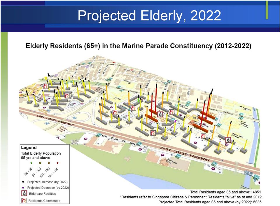
12 Projected Elderly, 2022
13 Real Time: Upper Respiratory Tract Infection Map

14 Sample image of Mobile Geospatial Statistics: Population Distribution of Central Tokyo (23 Wards) At 13:00 on a weekday Shibuya Shinjuku Ikebukuro Tokyo Ueno Estimated Pop in a 500m x 500m cell Taken from NTT docomo website

15 Tokyo Traffic Pattern- Congestion Heatmap, derived from mobile phone data, March, 2013, 7:23 pm

16 Modelling Racial Diversity in New York

17 Building geo-portal gathering data and utilizing them Static Information Building polygons Road network Census Findings Dynamic Information Seismic Intensity Tsunami Height Satellite Imagery Probe/sensor data Systematiz e Collaborat e Urban Resilience Geo Portal Online Utilize Provide scientific information Information for BIA Seismic hazard Damage Estimation Lifeline Interruption Business continuity Information for Drill Drill scenarios COP

18 Hurricane Sandy Damage Estimates

19 Hurricane Evacuation Zones (New York City)
")
20 Issues in Integrating Official Statistics and Geo-information A. Treating Location as Basic Unit of Observation; B. Full Integration of NSDI and NSDS: NSDI: National Spatial Data Infrastructure NSDS: National Strategy for Development of Statistics C. Governance and Institutional arrangement D. Evolving new National Information Infrastructure (NII)

21 Hierarchical Data Structure : Location as Basic Unit of Observation 25 Smith St, Town Z x,y: , Address / Geocode Cadastral property parcels Census Districts/Postal codes Block Face
22 From Polygons to Points of Relevance (POR) Users demand increasing precision. What is the smallest spatial unit possible?? area of interest intersection result
23 Smaller Polygons, More Precise Data Confidentiality the key constraint But users demand (and will supply) POR data area of interest intersection result
24 From Polygons to Point-Based Information Points likely to complement Polygons as the organizing framework for data integration, providing location-specific Information; The dynamic movement from Point to Point will pull out packets of Point-of-Relevance information on a string; Point-based information will be able to facilitate the convergence of information from multiple sources for a particular location; Points identified by Geocodes or Addresses.
25 Example from Chinese Taipei Problems Jurisdictional units is usually too large to provide detail information on local area of interest Original individual data Aggregated by village level boundaries Aggregated by township level boundaries
26
27 Census geography system of Kaohsiung City 6884 statistical areas st level dissemination areas nd level dissemination areas 11 3 rd level disseminations
28 Building Location-Based Data Structure No consistent Geocode to link statistical data to Location; Many countries working on National Address Management Framework to define an unique geocode data structure; Urgently need location-based data management practices with multiple databases linked through geocode; Statistical-Spatial Metadata Interoperability, Integrating SDMX/DDI (statistics) with ISO-19115; Need enabling policies and protocols.
29 Global Location Information: China s Global Land Cover Mapping Landsat MODIS m/ 250m Dataset Classification HJ 2000, m Single Class Map GLC Map validation Image Processing 30m\250m GLC Products FY m/ 250m Dataset integration editing Mapping land cover of the whole globe at 30 m and for two baseline years ( 2000 and 2010) The first time in the world GLC Information Portal From Prof Chen Jun, NASG
30 Global Land Surface Water From Prof Chen Jun, NASG
31 Assessment of Land Surface Water Areas Area of Surface Water (in 10,000 sq km) Change (in 10,000 sq km) % change Asia % Europe % Africa % North America % South America % From Prof Chen Jun, NASG
32 NSDI and NSDS at present two independent processes; NSDI sets norms for sharing spatial information; - Specifying the technology, policies, criteria, standards and people necessary to promote geospatial data sharing NSDS sets strategy for statistical development; - No reference to location information in NSDS Greater cooperation allow full implementation of Statistical Geospatial Framework (S. Africa as example)
33 Mapping agency and Statistical agency under different jurisdictions and with different mandates; Coordination needs to be further enhanced; Mapping agency primary responsibility is the base map and the geographic and cadastral layers; Statistical agency adds layers of information from their pool of official statistics, but also produce census maps; Coordination and collaboration based on mutual respect is important
34 Need a National Information Infrastructure (NII) to coordinate Data Fusion (meta data and layers); Need a core data system linking all agencies and new tools in information integration; Need new thinking on how to use information; Need a new national governance arrangement to manage the process of gathering and using information; Need cross-border coordination as well such as borderlands information systems or global thematic mapping.
35 Governments and enterprises have established Chief Data Officers (CDOs) to have the business responsibility to capture and exploit data for decision-making purposes; CDO s role will become more important in future, as decisions are based not on single source, but through data fusion and aggregation; CDO manages the location of central database and the coordination of information layers to enhance efficiency; The new NII will be critical for national competitiveness and productivity gain.
36 THANK YOU
Emerging Trends in SDI.
 Emerging Trends in SDI. Jeanne Foust ESRI gsdi 1 Spatial Data Infrastructure TRENDS GIS use continues to rapidly grow. Recognition Of GIS As Critical Infrastructure growing. Alignment of SDI and National
Technology Trends In Geoinformation
 Technology Trends In Geoinformation Dato Prof. Sr Dr. Abdul Kadir Bin Taib Department of Survey and Mapping Malaysia (JUPEM) Email: drkadir@jupem.gov.my www.jupem.gov.my NGIS 2008 3 rd. National GIS Conference
BROKERAGES AND NETWORKS: AN APPROACH TO MAKING GEOINFORMATION MORE AVAILABLE IN AFRICA
 BROKERAGES AND NETWORKS: AN APPROACH TO MAKING GEOINFORMATION MORE AVAILABLE IN AFRICA Craig Schwabe Director: GIS Centre Human Sciences Research Council (HSRC) Sives Govender, Gina Weir-Smith and Jacob
Towards a global statistical geospatial framework 1
 UNITED NATIONS SECRETARIAT ESA/STAT/AC.279/P3 Department of Economic and Social Affairs October 2013 Statistics Division English only United Nations Expert Group on the Integration of Statistical and Geospatial
Sharthi Laldaparsad. Statistics South Africa Executive Manager: Policy Research & Analysis. 1 August 2014, Washington DC, USA. Contents...
 Geographic Databases from population censuses to fundamental framework data for statistics to National Development Planning, Monitoring and Evaluating, South Africa Sharthi Laldaparsad Statistics South
GIS Initiative: Developing an atmospheric data model for GIS. Olga Wilhelmi (ESIG), Jennifer Boehnert (RAP/ESIG) and Terri Betancourt (RAP)
, Jennifer Boehnert (RAP/ESIG) and Terri Betancourt (RAP)") GIS Initiative: Developing an atmospheric data model for GIS Olga Wilhelmi (ESIG), Jennifer Boehnert (RAP/ESIG) and Terri Betancourt (RAP) Unidata seminar August 30, 2004 Presentation Outline Overview
GIS Initiative: Developing an atmospheric data model for GIS Olga Wilhelmi (ESIG), Jennifer Boehnert (RAP/ESIG) and Terri Betancourt (RAP) Unidata seminar August 30, 2004 Presentation Outline Overview
CIESIN Columbia University
 Conference on Climate Change and Official Statistics Oslo, Norway, 14-16 April 2008 The Role of Spatial Data Infrastructure in Integrating Climate Change Information with a Focus on Monitoring Observed
The Status of Geospatial Information Management in China
 The Status of Geospatial Information Management in China Submitted by the National Administration of Surveying, Mapping and Geoinformation of China 1. Administration System The National Administration
Big Data, Official Statistics and Social Science Research: Emerging Data Challenges
 Big Data, Official Statistics and Social Science Research: Emerging Data Challenges Professor Paul Cheung Director, United Nations Statistics Division Building the Global Information System Elements of
A Statistical Spatial Framework to Inform Regional Statistics
 A Statistical Spatial Framework to Inform Regional Statistics Martin Brady & Gemma Van Halderen Australian Bureau of Statistics, Canberra, Australia Corresponding Author: m.brady@abs.gov.au Abstract Statisticians
Utilizing space and GIS for effective disaster risk management -ESCAP's practices in Asia and the Pacific
 Utilizing space and GIS for effective disaster risk management -ESCAP's practices in Asia and the Pacific Mr. Keran Wang Chief, Space Applications Section Information and Communications Technology and
State of Israel Ministry of Housing and Construction Survey of Israel. system for the Israeli real estate market
 State of Israel Ministry of Housing and Construction Survey of Israel A Location Based Business Intelligence (LBBI) A system for the Israeli real estate market Established in 1920 by the British Mandate
Spatial Data Infrastructure of the Russian Federation: a new paradigm of openness
 Spatial Data Infrastructure of the Russian Federation: a new paradigm of openness Sergey Sapelnikov, Deputy Chairman of Rosreestr The Federal Service For State Registration, Cadaster and Cartography (ROSREESTR)
National Geographic Information System (NGIS) in Korea
 in Korea") National Geographic Information System (NGIS) in Korea : from a national policy point of view Jongnam Choi Western Illinois University Geospatial Information Research Center Korea Research Institute for
National Geographic Information System (NGIS) in Korea : from a national policy point of view Jongnam Choi Western Illinois University Geospatial Information Research Center Korea Research Institute for
Qatar National Geospatial Infrastructure
 Qatar National Geospatial Infrastructure Since 1990 up to 2030 and beyond Mohammad Abd El-Wahab Hamouda GIS Consultant & Chairman of GIS Coordinators Group The Center for GIS Ministry of Municipality and
PDOK Kaart, the Dutch Mapping API
 PDOK Kaart, the Dutch Mapping API Haico van der Vegt*, Leo van der Sluijs* * Cadastre, Land Registry and Mapping Agency of the Netherlands Abstract. PDOK (public services on the map) is a partnership of
CityGML goes to Broadway
 CityGML goes to Broadway Thomas H. Kolbe, Barbara Burger, Berit Cantzler Chair of Geoinformatics thomas.kolbe@tum.de September 11, 2015 Photogrammetric Week 2015, Stuttgart The New York City Open Data
Statistical and Spatial Frameworks. Standards and Data Infrastructure
 Distr. GENERAL 01 May 2013 WP.11 ENGLISH ONLY UNITED NATIONS ECONOMIC COMMISSION FOR EUROPE CONFERENCE OF EUROPEAN STATISTICIANS EUROPEAN COMMISSION STATISTICAL OFFICE OF THE EUROPEAN UNION (EUROSTAT)
Gram Panchayat & Ward Boundary Delineation and Assets mapping
 Gram Panchayat & Ward Boundary Delineation and Assets mapping For Rural Development Department & State Election Commission, Govt. of Maharashtra MAHARASHTRA REMOTE SENSING APPLICATIONS CENTRE Autonomous
ADWR GIS Metadata Policy
 ADWR GIS Metadata Policy 1 PURPOSE OF POLICY.. 3 INTRODUCTION.... 4 What is metadata?... 4 Why is it important? 4 When to fill metadata...4 STANDARDS. 5 FGDC content standards for geospatial metadata...5
Strategic Activities to Support Sustainability of Canada s Geospatial Data Infrastructure
 Strategic Activities to Support Sustainability of Canada s Geospatial Data Infrastructure Paula McLeod Canada Centre for Mapping and Earth Observation United Nations 10 th Regional Cartographic Conference
Big Data in the context of Preservation and Value Adding
 Big Data in the context of Preservation and Value Adding R. Leone, R. Cosac, I. Maggio, D. Iozzino ESRIN 06/11/2013 ESA UNCLASSIFIED Big Data Background ESA/ESRIN organized a 'Big Data from Space' event
Advanced Image Management using the Mosaic Dataset
 Esri International User Conference San Diego, California Technical Workshops July 25, 2012 Advanced Image Management using the Mosaic Dataset Vinay Viswambharan, Mike Muller Agenda ArcGIS Image Management
How To Use Inspire For Eo Data Processing
 INSPIREd computing for EO Based Services Paolo MANUNTA 1, Giulio CERIOLA 1, Jens STUTTE 1 1 Planetek Italia s.r.l Via Massaua 12 I-70132 Bari E-Mail: manunta@planetek.it Workshop Big Data Roma, 26/11/2013
Making Geospatial Data Available and Accessible in Jamaica
 Making Geospatial Data Available and Accessible in Jamaica Presented by Cecille Blake, National GIS Coordinator Office of the Prime Minister, National Spatial Data Management Division 9 th UNRCC New York
Spatial Analysis of Accessibility to Health Services in Greater London
 Spatial Analysis of Accessibility to Health Services in Greater London Centre for Geo-Information Studies University of East London June 2008 Contents 1. The Brief 3 2. Methods 4 3. Main Results 6 4. Extension
Advancing Sustainability with Geospatial Steven Hagan, Vice President, Server Technologies João Paiva, Ph.D. Spatial Information and Science
 Advancing Sustainability with Geospatial Steven Hagan, Vice President, Server Technologies João Paiva, Ph.D. Spatial Information and Science Engineering 1 Copyright 2011, Oracle and/or its affiliates.
DISASTER DISASTER MANAGEMENT CRISIS INFORMATICS GIS IN DIFFEERENT STAGES OF DISASTER MANAGEMENT
 APPLICATION OF GIS AND REMOTE SENSING IN DISASTER PRONE AREAS: A CASE STUDY IN COASTAL KERALA DISASTER Disaster is an unpleasant event than occurs with little or no warning which results in economic disruption,
Geospatial Information for disaster risk reduction and natural resources management. Rolando Ocampo Alcántar
 Geospatial Information for disaster risk reduction and natural resources management Rolando Ocampo Alcántar Content Background Geospatial Information for Disaster Management Risk Atlas Information Exchange
Metadata Hierarchy in Integrated Geoscientific Database for Regional Mineral Prospecting
 Metadata Hierarchy in Integrated Geoscientific Database for Regional Mineral Prospecting MA Xiaogang WANG Xinqing WU Chonglong JU Feng ABSTRACT: One of the core developments in geomathematics in now days
Principles and Practices of Data Integration
 Data Integration Data integration is the process of combining data of different themes, content, scale or spatial extent, projections, acquisition methods, formats, schema, or even levels of uncertainty,
Applying GIS in seismic hazard assessment and data integration for disaster management
 Applying GIS in seismic hazard assessment and data integration for disaster management Rumiana Vatseva, Dimcho Solakov, Emilia Tcherkezova, Stela Simeonova, Petya Trifonova National Institute of Geophysics,
Reading Questions. Lo and Yeung, 2007: 2 19. Schuurman, 2004: Chapter 1. 1. What distinguishes data from information? How are data represented?
 Reading Questions Week two Lo and Yeung, 2007: 2 19. Schuurman, 2004: Chapter 1. 1. What distinguishes data from information? How are data represented? 2. What sort of problems are GIS designed to solve?
Geo-information in The Hague & National SDI hub PDOK
 Geo-information in The Hague & National SDI hub PDOK dr.ir. Friso Penninga senior advisor at Municipality of The Hague & tactical advisor at Geonovum Contents 1. Introduction 2. GI in The Hague a. Overview
Thematic Map Types. Information Visualization MOOC. Unit 3 Where : Geospatial Data. Overview and Terminology
 Thematic Map Types Classification according to content: Physio geographical maps: geological, geophysical, meteorological, soils, vegetation Socio economic maps: historical, political, population, economy,
ArcGIS Data Models Practical Templates for Implementing GIS Projects
 ArcGIS Data Models Practical Templates for Implementing GIS Projects GIS Database Design According to C.J. Date (1995), database design deals with the logical representation of data in a database. The
A GIS helps you answer questions and solve problems by looking at your data in a way that is quickly understood and easily shared.
 A Geographic Information System (GIS) integrates hardware, software, and data for capturing, managing, analyzing, and displaying all forms of geographically referenced information. GIS allows us to view,
Unit 4: NIMS Communications and Information Management
 Unit 4: NIMS Communications and Information Management This page intentionally left blank. Objectives At the end of this unit, you should be able to: Describe the importance of communications and information
ABSTRACT INTRODUCTION PURPOSE
 EVALUATION OF TSUNAMI DISASTER BY THE 2011 OFF THE PACIFIC COAST OF TOHOKU EARTHQUAKE IN JAPAN BY USING TIME SERIES SATELLITE IMAGES WITH MULTI RESOLUTION Hideki Hashiba Associate Professor Department
The role of the Ina-SDI in supporting the development of the geospatial industry in Indonesia
 GEOGRAFIA Online TM Malaysia Journal of Society and Space 8 issue 1 (69-79) 69 The role of the Ina-SDI in supporting the development of the geospatial industry in Indonesia Asep Karsidi 1 National Coordinating
Geographic data linking in statistics Norwegian practices - With focus on the Norwegian Cadastre 1
 UNITED NATIONS SECRETARIAT SA/STAT/AC.279/P10 Department of Economic and Social Affairs October 2013 Statistics Division English only United Nations Expert Group on the Integration of Statistical and Geospatial
Unit 4: NIMS Communications and Information Management
 Unit 4: NIMS Communications and Information Management This page intentionally left blank. Objectives At the end of this unit, the participants should be able to: Describe the importance of communications
COUNTRY REPORT GEOSPATIAL INFORMATION MANAGEMENT IN NEPAL
 COUNTRY REPORT ON GEOSPATIAL INFORMATION MANAGEMENT IN NEPAL Government of Nepal Ministry of Land Reform and Management SURVEY DEPARTMENT PO Box 9435 Min Bhavan, Kathmandu Nepal Tel : + 977 1 4622713 +
How To Use Mdpropertyview
 RESIDENTIAL SALES DATA METHODOLOGY CY2014 (Prepared August 2015) The Sales data for calendar year (CY) 2014 are derived from the MdProperty View 1 Sales Databases created for Maryland s 23 counties and
National Data Sharing and Accessibility Policy (NDSAP)
") Draft National Data Sharing and Accessibility Policy (NDSAP) 1. Introduction 1.1 Data are recognized at all levels as a valuable resource that should be made publicly available and maintained over time
Draft National Data Sharing and Accessibility Policy (NDSAP) 1. Introduction 1.1 Data are recognized at all levels as a valuable resource that should be made publicly available and maintained over time
Commercial Internet Mapping Impacts on Government Investments in GIS. Wansoo Im, Ph.D. VERTICES, LLC New Brunswick, NJ
 Commercial Internet Mapping Impacts on Government Investments in GIS Wansoo Im, Ph.D. VERTICES, LLC New Brunswick, NJ Acknowledgements: Research funded by the Korean Land Spatialization Group Principal
Assessing the implementation of Rawalpindi s Guided Development Plan through GIS and Remote Sensing Muhammad Adeel
 Assessing the implementation of Rawalpindi s Guided Development Plan through GIS and Remote Sensing Muhammad Adeel (Lecturer Muhammad Adeel, Institute of Geographical Information Systems, NUST, H-12 Islamabad,
A Sub-Scheme under AMRUT
 1 A Sub-Scheme under AMRUT TITLE Sub-Mission under AMRUT - Formulation of GIS-Based Master Plans for AMRUT Cities 1. OBJECTIVES The objective is to develop common digital geo-referenced base maps and land
Emergency Alert Broadcast System Establishment
 Emergency Alert Broadcast System Establishment Tzu-Yin CHANG National Science and Technology Center for Disaster Reduction Background- CBS Program Lesson learned CBS(Cell Broadcast Service) Application
Creating common operational pictures for disaster response with collaborative work
 Risk Analysis IX 393 Creating common operational pictures for disaster response with collaborative work T. Chen, G. Su & H. Yuan Institute of Public Safety Research, Department of Physics Engineering,
The UCC-21 cognitive skills that are listed above will be met via the following objectives.
 Master Syllabus Department of Geography GEOG 265: Introduction to Geographic Information Systems Course Description Fundamentals of geographic information systems (GIS). How to visualize geographic information
The Effect of GIS Data Quality on Infrastructure Planning: School Accessibility in the City of Tshwane, South Africa
 The Effect of GIS Data Quality on Infrastructure Planning: School Accessibility in the City of Tshwane, South Africa Dr Peter Schmitz 1,2, Sanet Eksteen 3 1 CSIR Built Environment, pschmitz@csir.co.za
NIPP. Ivica Skender NSDI Working group for technical standards
 Implementing rules for network services Ivica Skender NSDI Working group for technical standards ivica.skender@gisdata.com Content Working group for technical standards INSPIRE implementing rule for Network
MSDI: Workflows, Software and Related Data Standards
 MSDI: Workflows, Software and Related Data Standards By Andy Hoggarth October 2009 Introduction Leveraging SDI principles for hydrographic operational efficiency French INFRAGEOS example (SHOM - Service
2015 Global Risk Assessment. Sahar Safaie Program Officer, UNISDR Risk Knowledge Section
 2015 Global Risk Assessment Sahar Safaie Program Officer, UNISDR Risk Knowledge Section Outline Global Assessment Report (GAR) evolution Global Risk Assessment for GAR15 Objective Scope Audience/Users
Spatial Data Warehouse (SDW) & AltaLIS. Presentation to NSGIC. National States Geographic Information Council. Annapolis, Maryland.
 & AltaLIS. Presentation to NSGIC. National States Geographic Information Council. Annapolis, Maryland.") Spatial Data Warehouse (SDW) & AltaLIS Presentation to NSGIC National States Geographic Information Council Annapolis, Maryland February 24, 2013 Spatial Data Warehouse (SDW) & AltaLIS A DATA related Public-Private
Spatial Data Warehouse (SDW) & AltaLIS Presentation to NSGIC National States Geographic Information Council Annapolis, Maryland February 24, 2013 Spatial Data Warehouse (SDW) & AltaLIS A DATA related Public-Private
Enabling embedded maps
 Enabling embedded maps Case: National geoportal of Finland Antti Rainio National Land Survey of Finland Trends: Web Services, Mapping Mashup, Open Source, Open Data Decentralised data s Service interfaces
Guidance for Flood Risk Analysis and Mapping. Changes Since Last FIRM
 Guidance for Flood Risk Analysis and Mapping Changes Since Last FIRM May 2014 This guidance document supports effective and efficient implementation of flood risk analysis and mapping standards codified
Aerial imagery and geographic information systems used in the asbestos removal process in Poland
 Towards Horizon 2020 Lasaponara R., Masini N., Biscione M., Editors EARSeL, 2013 Aerial imagery and geographic information systems used in the asbestos removal process in Małgorzata Krówczyńska 1, Ewa
A WEB GIS FOR WETLANDS OF KERALA USING OPEN SOURCE GEOSPATIAL SOFTWARE. Santosh Gaikwad* and S Narendra Prasad**
 A WEB GIS FOR WETLANDS OF KERALA USING OPEN SOURCE GEOSPATIAL SOFTWARE Santosh Gaikwad* and S Narendra Prasad** Salim Ali Centre for Ornithology and Natural History Deccan Regional Station, Hyderabad *gaikwadss@rediffmail.com
Polish Spatial Data Infrastructure - from the Concept towards its Implementation
 Polish Spatial Data Infrastructure - from the Concept towards its Implementation 8th EC-GI&GIS Workshop ESDI A Work in Progress Dublin, July 3-5 June 2001 r. Adam Linsenbarth, Ewa Wysocka Institute of
Development and Deployment of GIS Based Spatial Decision Support System. for. Greater NOIDA Industrial Development Authority
 Development and Deployment of GIS Based Spatial Decision Support System for Greater NOIDA Industrial Development Authority About Development Authority in India Development Authorities in India play a very
CDI SSF Category 1: Management, Policy and Standards
 CDI SSF Category 1: Management, Policy and Standards Developing a Data Management Plan for Implementation: Best Practices for the Collection, Management, Storing, and Sharing of Geospatial and Non-geospatial
The Use of Inter-Governated Mapging and Geospatial Information Services
 United Nations E/2011/89 Economic and Social Council ADVANCE UNEDITED COPY Distr.: General 12 May 2011 Substantive session of 2011 Geneva, 4-29 July 2011 Item 13(j) of the provisional agenda* Economic
The Open Source Approach in Spatial Planning: Applicability Challenges in Bulgaria
 10th Network Conference The Role and Future of Spatial Planning in Central, Eastern and South-Eastern Europe 26-27 September 2013, Dresden The Open Source Approach in Spatial Planning: Applicability Challenges
Panel Remarks by Mr Mmboneni Muofhe, GEO Principal Alternate, Deputy Director General, Department of Science and Technology, South Africa
 UNGGIM- HLF, 20 22 April 2016, Addis Ababa, Ethiopia Session 1: Land Information for Sustainable Development Sub- Session: Addressing challenges confronting countries 20 April 2016: 15h45 17h00 Panel Remarks
China s Global Land Cover Mapping at 30 M Resolution
 Geospatial World Forum 2015 China s Global Land Cover Mapping at 30 M Resolution Jun Chen1,2 1 National Geomatics Center, 2ISPRS Lisbon, Portugal, May 28,2015 GlobeLand30 Video Contents Introduction Introduction
Product Navigator User Guide
 Product Navigator User Guide Table of Contents Contents About the Product Navigator... 1 Browser support and settings... 2 Searching in detail... 3 Simple Search... 3 Extended Search... 4 Browse By Theme...
CARLTON COUNTY GIS DATA DISTRIBUTION POLICY June 1, 2010 Revised March 25, 2015
 Page 1 of 9 CARLTON COUNTY Introduction: Many units of government in Minnesota are exploring new processes to provide public access to information created in their Geographic Information Systems (GIS).
Chapter 9: Transportation
 Chapter 9: Transportation What is this chapter about? The goals and policies in this chapter convey the City s intent to: Create a coordinated, efficient, and more affordable multimodal transportation
Earth Observation Group
 Centrum Badań Kosmicznych Polskiej Akademii Nauk Space Research Centre of the Polish Academy of Sciences Head of Dr. Habil. Eng. Stanisław Lewiński, Prof. CBK PAN e-mail: stlewinski@cbk.waw.pl Tel: (+48)
M2M ATDI services. M2M project development, Business model, Connectivity.
 M2M ATDI services M2M project development, Business model, Connectivity. Introduction Thanks to our leadership in Spectrum management, Prospective planning, Network deployment, ATDI was/is involved in
Monica Pratesi, University of Pisa
 DEVELOPING ROBUST AND STATISTICALLY BASED METHODS FOR SPATIAL DISAGGREGATION AND FOR INTEGRATION OF VARIOUS KINDS OF GEOGRAPHICAL INFORMATION AND GEO- REFERENCED SURVEY DATA Monica Pratesi, University
Introduction to GIS (Basics, Data, Analysis) & Case Studies. 13 th May 2004. Content. What is GIS?
 & Case Studies. 13 th May 2004. Content. What is GIS?") Introduction to GIS (Basics, Data, Analysis) & Case Studies 13 th May 2004 Content Introduction to GIS Data concepts Data input Analysis Applications selected examples What is GIS? Geographic Information
Introduction to GIS (Basics, Data, Analysis) & Case Studies 13 th May 2004 Content Introduction to GIS Data concepts Data input Analysis Applications selected examples What is GIS? Geographic Information
Tracking Track anything from relatively simplistic commercial GPS-enabled cell phones to complex military grade GPS signals.
 HazNet has been developed specifically to reduce the risk and attendant costs of moving and managing Hazardous Materials. The key to the efficiency of this system was the integration of IRRIS. IRRIS developed
Next Generation Archives: The NC Geospatial Data Archiving Project
 Next Generation Archives: The NC Geospatial Data Archiving Project Jeff Essic North Carolina State University Libraries Zsolt Nagy North Carolina Center for Geographic Information and Analysis Coastal
Constructing an EA-level Database. for the Census
 Constructing an EA-level Database for the Census Amor Laaribi UN-GGIM Secretariat UN Statistics Division New York 1 Overview Stages in the Geographic Database Development Sources of geographic information
An ESRI White Paper May 2007 GIS Supporting the Homeland Security Mission
 An ESRI White Paper May 2007 GIS Supporting the Homeland Security Mission ESRI 380 New York St., Redlands, CA 92373-8100 USA TEL 909-793-2853 FAX 909-793-5953 E-MAIL info@esri.com WEB www.esri.com Copyright
DATA VISUALIZATION GABRIEL PARODI STUDY MATERIAL: PRINCIPLES OF GEOGRAPHIC INFORMATION SYSTEMS AN INTRODUCTORY TEXTBOOK CHAPTER 7
 DATA VISUALIZATION GABRIEL PARODI STUDY MATERIAL: PRINCIPLES OF GEOGRAPHIC INFORMATION SYSTEMS AN INTRODUCTORY TEXTBOOK CHAPTER 7 Contents GIS and maps The visualization process Visualization and strategies
Digital Cadastral Maps in Land Information Systems
 LIBER QUARTERLY, ISSN 1435-5205 LIBER 1999. All rights reserved K.G. Saur, Munich. Printed in Germany Digital Cadastral Maps in Land Information Systems by PIOTR CICHOCINSKI ABSTRACT This paper presents
How To Design A Three Dimensional Property Right Database For Turkey
 African Journal of Business Management Vol. 5(22), pp. 9440-9447, 30 September, 2011 Available online at http://www.academicjournals.org/ajbm ISSN 1993-8233 2011 Academic Journals Full Length Research
Geocoding in Law Enforcement Final Report
 Geocoding in Law Enforcement Final Report Geocoding in Law Enforcement Final Report Prepared by: The Crime Mapping Laboratory Police Foundation August 2000 Report to the Office of Community Oriented Policing
Contents. Specific and total risk. Definition of risk. How to express risk? Multi-hazard Risk Assessment. Risk types
 Contents Multi-hazard Risk Assessment Cees van Westen United Nations University ITC School for Disaster Geo- Information Management International Institute for Geo-Information Science and Earth Observation
Using Commercial Software to Enhance Commercial Imaging Acquisition
 Using Commercial Software to Enhance Commercial Imaging Acquisition Adam Gorski, Analytical Graphics, Inc., Exton, PA USA, Email: agorski@agi.com April 2011 Abstract This paper documents the ways commercially
Exploiting Spatial Data for Site Declaration. 21 October 2014 Graham Smith Bruce Power LP Ontario, Canada
 Exploiting Spatial Data for Site Declaration 21 October 2014 Graham Smith Bruce Power LP Ontario, Canada Topics About Bruce Power Geographic Information Systems - GIS GIS at Bruce Power A Data Sharing
APLS 2011. GIS Data: Classification, Potential Misuse, and Practical Limitations
 APLS 2011 GIS Data: Classification, Potential Misuse, and Practical Limitations GIS Data: Classification, Potential Misuse, and Practical Limitations Goals & Objectives Develop an easy to use geospatial
CAPITAL REGION GIS SPATIAL DATA DEMONSTRATION PROJECT
 CAPITAL REGION GIS SPATIAL DATA DEMONSTRATION PROJECT DRAFT January 2013 Prepared by: O2 Planning + Design, Inc. The information contained in this document has been compiled by O2 Planning + Design Inc.
What is GIS? Why Geography?
 Geographic Information System (GIS), What is GIS? contributed by the Spatial Data Management Division, secretariat of the Land Information Council of Jamaica (LICJ), Ministry of Agriculture. Contact Ms.
Report from Work Group B Data Integration
 Report from Work Group B Data Integration UN-GGIM: Europe Regional Committee 7 th October 2015 Copyright 2013 EuroGeographics Tasks for Work Group B: Data Integration Supply three deliverables: 1. Definition
Implementing Geospatial Data in Parametric Environment Elçin ERTUĞRUL*
 Proceedings of the International Association for Shell and Spatial Structures (IASS) Symposium 2015, Amsterdam 17-20 August 2015, Amsterdam, The Netherlands Implementing Geospatial Data in Parametric Environment
State of North Dakota. GIS Program Strategic Plan 2015-2017
 State of North Dakota GIS Program Strategic Plan 2015-2017 Prepared By: Bob Nutsch GIS Coordinator Information Technology Department Approved By: North Dakota GIS Technical Committee Date of Publication:
ESRI Business Analyst for Telecommunications
 ESRI Business Analyst for Telecommunications GIS Market Analysis Package Drive Business Results with ESRI Business Analyst ESRI Business Analyst helps you Analyze your competition: Track customer churn.
Mongolian National Spatial Data Infrastructure
 Mongolian National Spatial Data Infrastructure S.Enkhtuya Chief of Spatial Data Infrastructure Department of Administration of Land Affairs, Geodesy and Cartography Beijing. 2014 ORGANIZATIONAL STRUCTURE
Global Geospatial Information Management. Legal and Policy Challenges
 Creating the Policy and Legal Framework for a Location-Enabled Society 2013 Annual CGA Conference, 2-3 May 2013, Cambridge MA Global Geospatial Information Management Legal and Policy Challenges Greg Scott
The needs on big data management for Operational Geo-Info Services: Emergency Response, Maritime surveillance, Agriculture Management
 Copernicus Big-Data Workshop 2014, 13/14 March The needs on big data management for Operational Geo-Info Services: Emergency Response, Maritime surveillance, Agriculture Management Marco Corsi e-geos 1
Developing Business Intelligence and Data Visualization Applications with Web Maps
 Developing Business Intelligence and Data Visualization Applications with Web Maps Introduction Business Intelligence (BI) means different things to different organizations and users. BI often refers to
Strategy for Improving Cadastral Spatial Quality toward Effective e- Government based NSDI
 Strategy for Improving Cadastral Spatial Quality toward Effective e- Government based NSDI Young-ho LEE, Republic of Korea Key words: e-government, interoperability, NSDI, Spatial quality SUMMARY E-Government
Data access and management
 B Data access and management CONTENTS B.1 Introduction... B-1 B.2 Data requirements and availability... B-1 B.3 Data access... B-2 B.4 Overall procedures... B-2 B.5 Data tools and management... B-4 Appendix
Oracle Platform GIS & Location-Based Services. Fred Louis Solution Architect Ohio Valley
 Oracle Platform GIS & Location-Based Services Fred Louis Solution Architect Ohio Valley Overview Geospatial Technology Trends Oracle s Spatial Technologies Oracle10g Locator Spatial Oracle Application
The Challenges of Geospatial Analytics in the Era of Big Data
 The Challenges of Geospatial Analytics in the Era of Big Data Dr Noordin Ahmad National Space Agency of Malaysia (ANGKASA) CITA 2015: 4-5 August 2015 Kuching, Sarawak Big datais an all-encompassing term