The Challenges of Geospatial Analytics in the Era of Big Data
|
|
|
- Cathleen Suzanna Logan
- 8 years ago
- Views:
Transcription

 CITA 2015: 4-5 August 2015")
1 The Challenges of Geospatial Analytics in the Era of Big Data Dr Noordin Ahmad National Space Agency of Malaysia (ANGKASA) CITA 2015: 4-5 August 2015 Kuching, Sarawak
 CITA 2015: 4-5 August 2015")
2 Big datais an all-encompassing term for any collection of datasets so large and complex that it becomes difficult to process them using traditionaldataprocessing applications.

3 ?

4
5 Big Geospatial Data. Big processing of big imagery data Imagery analysis in the cloud has become a reality through web services. Flood of Big Data comes from mobile devices. Big Data analytics is an effective way to enhance the power of location with many comes from mobile devices. GIS moves to processing in the cloud. Apache Hadoop, an open source framework based on Google s MapReduce, has been used by many projects to perform geospatial processing in the cloud or in cloud-like enterprise data centers. Transaction oriented analytics: processing of streaming spatial data. Relationships become more apparent with each user interaction, each addition of data or each new algorithm that's introduced in a discovery session.

6

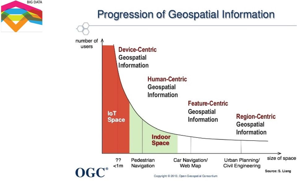
7 SATELLITE TRANSPORTING BIG DATA DISTRIBUTED DATA CENTRES

8 Global Forest Extent and Change Years of data 700 Terapixels of data 654k Landsat scenes 1M Hours of computation 10,000 CPUs used 4 Days to complete Source: Hansen, Potapov, Moore, Hancher et al., Science, 15 November

9 Till now Geospatial Big Data analytics has focussed on Data visualisation

10 Reliable sources of geospatial information are essential to support broad national objectives such as economic growth, social cohesion and well-being, and environmental management 4

11 Phase Data Type Example Data Sets Notes Preparedness and Early Warning User-generated Twitter (food crisis, earthquake), web traffic (Flu) Requires machine learning, classification algorithms e.g. Big Data for Disaster Risk Reduction Impact and Response Sensor Precipitation (PERSIAN, TRMM), evapotranspiration, soil moisture, temperature, vegetation density and water content (MODIS, LANDSAT), groundwater levels (GRACE) User-generated CDR, Flickr, Twitter Sensor Imagery(LANDSAT, MODIS, Geoeye) thermal (LANDSAT, MODIS), radar (RADARSAT-1, CARTOSAT), spatial video Should be paired with validated and calibrated biophysical models. Used for droughts, floods, fires, epidemics. Requires verification, algorithms to separate signal from noise. CDR data requires agreement with cell provider Crowdsourcing aids damage detection. Crisis map mash ups by volunteer cartographers help publicize and visualize data. Mitigation, Risk and Vulnerability Modeling User-generated CDR, emergency call content, facebook sensor Nighttime Lights (NTL), Imagery, thermal, Radar, spatial video, Temporal Flood Inundation Mapping (GIEMS) Data may not be representative of population. Populations without electricity not identified by NTL. Must be paired with socioecological vulnerability models. Uncertainty and scale issues. institutional, public GCM (Global Climate Model), Transportation data (subway, bikeshare), census, Worldpop, Open Cities Issues in uncertainty- GCMs are most uncertain at predicting extremes, Worldpop combines data scales for modeling and has associated uncertainties

12 The process..

13 The challenge of making the Technology trends into Reliable Data (Values) Technological/Trends Open Data Volunteered Geographic Information (VGI) Open Source Web 2.0 and the GeoWeb Cloud Computing Mobile and Location-based Services High Resolution Imagery Mass Market Geomatics Big data /data Integration Legal/Administrative Issues Ethical Legal Practices Confidentiality, Security, and Sensitive Information Privacy Intellectual Property Copyright Licensing Data Sharing Liability Archiving and Preservation Data Quality

14 Collaborative Decision Making Geospatial Data Sharing & Collaboration: Leveraging Agency Datasets Promotes Open Government Benefits of Collaborative Decision Making fom Geospatial Big Data: Same Map at the Same Time Shared Data Across Platforms Accelerates Situational Awareness Accelerates Decision Making Leverages Common Operating Pictures already in use

15 Complex Event Processing (CEP) rapid event processing, in-depth impact analysis, pattern matching etc. INSIGHT 1. Capture: data capture and collection is where the cycle begins 2. Understand: data is only useful as the raw material of insight and understanding. 3. Model : requires more robust analytics capability. Complex event processing revolves around two poles: insight and action ( ACTION 1. Decide: the power of real-time data analysis is its ability to enable real-time decisions. 2. Act: once the system have determined a particular response to this complex chain of events, it must be acted upon quickly. 3. Monitor: the efficacy of actions must be measured.

16 3 main type of Geospatial analytics 1.Predictive analytics Likelihood of future events or happenings.

17 2. Operational Intelligence Dynamic, business analytics that delivers visibility and insight into business operations. For instance, a wireless telephone company that monitors its network could use location data to determine which cell tower to fix based on where their high value customers are located.

18 3. Situational intelligence Integrates and correlates large volumes of multidimensional real time and historical data to identify and act on a problem. Visualizing and analyzing this data can help answer questions like what happened, where did it happen, and why did it happen.

19
20
Strategic Activities to Support Sustainability of Canada s Geospatial Data Infrastructure
 Strategic Activities to Support Sustainability of Canada s Geospatial Data Infrastructure Paula McLeod Canada Centre for Mapping and Earth Observation United Nations 10 th Regional Cartographic Conference
Overview. What are operational policies? Development, adoption, implementation
 Practical Geospatial Policies: Resolving Operational Issues to Optimize Your SDI Ed Kennedy Hickling Arthurs Low Corporation and Cynthia Mitchell and Simon Riopel Division, Natural Resources Canada Overview
Trends and Research Opportunities in Spatial Big Data Analytics and Cloud Computing NCSU GeoSpatial Forum
 Trends and Research Opportunities in Spatial Big Data Analytics and Cloud Computing NCSU GeoSpatial Forum Siva Ravada Senior Director of Development Oracle Spatial and MapViewer 2 Evolving Technology Platforms
How To Create A Data Science System
 Enhance Collaboration and Data Sharing for Faster Decisions and Improved Mission Outcome Richard Breakiron Senior Director, Cyber Solutions Rbreakiron@vion.com Office: 571-353-6127 / Cell: 803-443-8002
The needs on big data management for Operational Geo-Info Services: Emergency Response, Maritime surveillance, Agriculture Management
 Copernicus Big-Data Workshop 2014, 13/14 March The needs on big data management for Operational Geo-Info Services: Emergency Response, Maritime surveillance, Agriculture Management Marco Corsi e-geos 1
Welcome to NASA Applied Remote Sensing Training (ARSET) Webinar Series
 Webinar Series") Welcome to NASA Applied Remote Sensing Training (ARSET) Webinar Series Introduction to Remote Sensing Data for Water Resources Management Course Dates: October 17, 24, 31 November 7, 14 Time: 8-9 a.m.
Welcome to NASA Applied Remote Sensing Training (ARSET) Webinar Series Introduction to Remote Sensing Data for Water Resources Management Course Dates: October 17, 24, 31 November 7, 14 Time: 8-9 a.m.
Geospatial Software Solutions for the Environment and Natural Resources
 Geospatial Software Solutions for the Environment and Natural Resources Manage and Preserve the Environment and its Natural Resources Our environment and the natural resources it provides play a growing
General overview, and sources and uses of Big Data for urban and regional analysis
 General overview, and sources and uses of Big Data for urban and regional analysis Carson Farmer! @carsonfarmer " carsonfarmer.com # carson.farmer@hunter.cuny.edu TRB Executive Committee Policy Session,
GEOGRAPHIC CONTEXT ANALYSIS OF VOLUNTEERED INFORMATION
 GEOGRAPHIC CONTEXT ANALYSIS OF VOLUNTEERED INFORMATION (GEOCONAVI) Frank O. Ostermann COST Energic Meeting 26.05.2014, Zürich GEOGRAPHIC CONTEXT ANALYSIS OF VOLUNTEERED INFORMATION PRESENTATION OVERVIEW
Big Data and Analytics: Getting Started with ArcGIS. Mike Park Erik Hoel
 Big Data and Analytics: Getting Started with ArcGIS Mike Park Erik Hoel Agenda Overview of big data Distributed computation User experience Data management Big data What is it? Big Data is a loosely defined
Technology Trends In Geoinformation
 Technology Trends In Geoinformation Dato Prof. Sr Dr. Abdul Kadir Bin Taib Department of Survey and Mapping Malaysia (JUPEM) Email: drkadir@jupem.gov.my www.jupem.gov.my NGIS 2008 3 rd. National GIS Conference
Review for Introduction to Remote Sensing: Science Concepts and Technology
 Review for Introduction to Remote Sensing: Science Concepts and Technology Ann Johnson Associate Director ann@baremt.com Funded by National Science Foundation Advanced Technological Education program [DUE
Big Data analytics: turning insight into action
 Big Data analytics: turning insight into action New technologies accelerate data discovery 1 ExEcutivE summary the core of business intelligence (Bi) is the transformation of data into insight and insight
Technology Implications of an Instrumented Planet presented at IFIP WG 10.4 Workshop on Challenges and Directions in Dependability
 Technology Implications of an Instrumented Planet presented at IFIP WG 10.4 Workshop on Challenges and Directions in Dependability Nick Bowen Colin Harrison IBM June 2008 1 Background Global Technology
Big Data, Cloud Computing, Spatial Databases Steven Hagan Vice President Server Technologies
 Big Data, Cloud Computing, Spatial Databases Steven Hagan Vice President Server Technologies Big Data: Global Digital Data Growth Growing leaps and bounds by 40+% Year over Year! 2009 =.8 Zetabytes =.08
Big Data and Analytics: Challenges and Opportunities
 Big Data and Analytics: Challenges and Opportunities Dr. Amin Beheshti Lecturer and Senior Research Associate University of New South Wales, Australia (Service Oriented Computing Group, CSE) Talk: Sharif
COMP9321 Web Application Engineering
 COMP9321 Web Application Engineering Semester 2, 2015 Dr. Amin Beheshti Service Oriented Computing Group, CSE, UNSW Australia Week 11 (Part II) http://webapps.cse.unsw.edu.au/webcms2/course/index.php?cid=2411
Creating a More Resilient Future. Friday 30 May, 11:00 to 12:30, Rooms S29-31
 Creating a More Resilient Future Friday 30 May, 11:00 to 12:30, Rooms S29-31 Empowering Resilience With GIS ICLEI Smart Resilient Cities Strategic Use of Spatial Systems Jim Geringer, Esri Former Governor,
A Hurwitz white paper. Inventing the Future. Judith Hurwitz President and CEO. Sponsored by Hitachi
 Judith Hurwitz President and CEO Sponsored by Hitachi Introduction Only a few years ago, the greatest concern for businesses was being able to link traditional IT with the requirements of business units.
Sustainable Development with Geospatial Information Leveraging the Data and Technology Revolution
 Sustainable Development with Geospatial Information Leveraging the Data and Technology Revolution Steven Hagan, Vice President, Server Technologies 1 Copyright 2011, Oracle and/or its affiliates. All rights
Overview of NASA Applied Remote Sensing Training Program on Water Resources and Disaster Management
 Overview of NASA Applied Remote Sensing Training Program on Water Resources and Disaster Management ARSET Applied Remote SEnsing Training A project of NASA Applied Sciences Outline About ARSET ARSET Trainings
Use of GIS in Planning and Asset Management
 Use of GIS in Planning and Asset Management Technology Developments and Practical Uses Jay Adams Oklahoma DOT Pam Jurney Cross Timbers Consulting GIS Is Evolving Rapidly Millions Organizations 100 s
ENVIRONMENTAL MONITORING Vol. I - Remote Sensing (Satellite) System Technologies - Michael A. Okoye and Greg T. Koeln
 System Technologies - Michael A. Okoye and Greg T. Koeln") REMOTE SENSING (SATELLITE) SYSTEM TECHNOLOGIES Michael A. Okoye and Greg T. Earth Satellite Corporation, Rockville Maryland, USA Keywords: active microwave, advantages of satellite remote sensing, atmospheric
REMOTE SENSING (SATELLITE) SYSTEM TECHNOLOGIES Michael A. Okoye and Greg T. Earth Satellite Corporation, Rockville Maryland, USA Keywords: active microwave, advantages of satellite remote sensing, atmospheric
The following was presented at DMT 14 (June 1-4, 2014, Newark, DE).
.") DMT 2014 The following was presented at DMT 14 (June 1-4, 2014, Newark, DE). The contents are provisional and will be superseded by a paper in the DMT 14 Proceedings. See also presentations and Proceedings
DMT 2014 The following was presented at DMT 14 (June 1-4, 2014, Newark, DE). The contents are provisional and will be superseded by a paper in the DMT 14 Proceedings. See also presentations and Proceedings
The Future of Geospatial Big Data Giovanni Marchisio, Ph.D., Director Product Development
 The Future of Geospatial Big Data Giovanni Marchisio, Ph.D., Director Product Development Nuclear Power Plant, Doel, Belgium December 10, 2011 WorldView-2 Why Geospatial Big Data? We Are the Innovators
Big Data a threat or a chance?
 Big Data a threat or a chance? Helwig Hauser University of Bergen, Dept. of Informatics Big Data What is Big Data? well, lots of data, right? we come back to this in a moment. certainly, a buzz-word but
ACTIVITY & LOCATION BASED ANALYTICS APPLICATIONS
 ACTIVITY & LOCATION BASED ANALYTICS APPLICATIONS SEAMLESS, REAL TIME MERGING OF GIS AND ERP SYSTEMS ALLOWING THE VISUALIZATION OF RELATIONSHIPS, CONNECTIONS AND PATTERNS IN THE DATA FOR INTELLIGENT, INFORMED
Monitoring Soil Moisture from Space. Dr. Heather McNairn Science and Technology Branch Agriculture and Agri-Food Canada heather.mcnairn@agr.gc.
 Monitoring Soil Moisture from Space Dr. Heather McNairn Science and Technology Branch Agriculture and Agri-Food Canada heather.mcnairn@agr.gc.ca What is Remote Sensing? Scientists turn the raw data collected
The business of the environment
 26/06/2015 The business of the environment Prof. Simon Pollard, Pro-Vice-Chancellor The Foundation for Science and Technology, 24th June 2015 Strategies for resolving the tension between resource extraction
Integrating a Big Data Platform into Government:
 Integrating a Big Data Platform into Government: Drive Better Decisions for Policy and Program Outcomes John Haddad, Senior Director Product Marketing, Informatica Digital Government Institute s Government
Where is... How do I get to...
 Big Data, Fast Data, Spatial Data Making Sense of Location Data in a Smart City Hans Viehmann Product Manager EMEA ORACLE Corporation August 19, 2015 Copyright 2014, Oracle and/or its affiliates. All rights
INTELLIGENT BUSINESS STRATEGIES WHITE PAPER
 INTELLIGENT BUSINESS STRATEGIES WHITE PAPER Improving Access to Data for Successful Business Intelligence Part 2: Supporting Multiple Analytical Workloads in a Changing Analytical Landscape By Mike Ferguson
Integrated Water Resources Science and Services. National Water Center
 TOO MUCH POOR QUALITY TOO LITTLE Integrated Water Resources Science and Services and the National Water Center Partnering to Address America s Water Resources Information Needs Mary G. Mullusky National
How to use Big Data in Industry 4.0 implementations. LAURI ILISON, PhD Head of Big Data and Machine Learning
 How to use Big Data in Industry 4.0 implementations LAURI ILISON, PhD Head of Big Data and Machine Learning Big Data definition? Big Data is about structured vs unstructured data Big Data is about Volume
Advanced Image Management using the Mosaic Dataset
 Esri International User Conference San Diego, California Technical Workshops July 25, 2012 Advanced Image Management using the Mosaic Dataset Vinay Viswambharan, Mike Muller Agenda ArcGIS Image Management
Advancing Sustainability with Geospatial Steven Hagan, Vice President, Server Technologies João Paiva, Ph.D. Spatial Information and Science
 Advancing Sustainability with Geospatial Steven Hagan, Vice President, Server Technologies João Paiva, Ph.D. Spatial Information and Science Engineering 1 Copyright 2011, Oracle and/or its affiliates.
Chapter Contents Page No
 Chapter Contents Page No Preface Acknowledgement 1 Basics of Remote Sensing 1 1.1. Introduction 1 1.2. Definition of Remote Sensing 1 1.3. Principles of Remote Sensing 1 1.4. Various Stages in Remote Sensing
Visualize your World. Democratization i of Geographic Data
 Visualize your World Democratization i of Geographic Data Session Agenda Google GEO Solutions - More than just a Map Enabling our Government Customers- Examples Summary & Invite to Learn More About Google
Bruhati Technologies. About us. ISO 9001:2008 certified. Technology fit for Business
 Bruhati Technologies ISO 9001:2008 certified Technology fit for Business About us 1 Strong, agile and adaptive Leadership Geared up technologies for and fast moving long lasting With sound understanding
Integrated Risk Management System Components in the GEO Architecture Implementation Pilot Phase 2 (AIP-2)
") Meraka Institute ICT for Earth Observation PO Box 395 Pretoria 0001, Gauteng, South Africa Telephone: +27 12 841 3028 Facsimile: +27 12 841 4720 University of KwaZulu- Natal School of Computer Science
Meraka Institute ICT for Earth Observation PO Box 395 Pretoria 0001, Gauteng, South Africa Telephone: +27 12 841 3028 Facsimile: +27 12 841 4720 University of KwaZulu- Natal School of Computer Science
Are You Ready for Big Data?
 Are You Ready for Big Data? Jim Gallo National Director, Business Analytics April 10, 2013 Agenda What is Big Data? How do you leverage Big Data in your company? How do you prepare for a Big Data initiative?
BIG DATA TRENDS AND TECHNOLOGIES
 BIG DATA TRENDS AND TECHNOLOGIES THE WORLD OF DATA IS CHANGING Cloud WHAT IS BIG DATA? Big data are datasets that grow so large that they become awkward to work with using onhand database management tools.
Providing drivers with actionable intelligence can minimize accidents, reduce driver claims and increase your bottom line. Equip motorists with the
 Providing drivers with actionable intelligence can minimize accidents, reduce driver claims and increase your bottom line. Equip motorists with the ability to make informed decisions based on reliable,
The 4 Pillars of Technosoft s Big Data Practice
 beyond possible Big Use End-user applications Big Analytics Visualisation tools Big Analytical tools Big management systems The 4 Pillars of Technosoft s Big Practice Overview Businesses have long managed
Big Data: Overview and Roadmap. 2015 eglobaltech. All rights reserved.
 Big Data: Overview and Roadmap 2015 eglobaltech. All rights reserved. What is Big Data? Large volumes of complex and variable data that require advanced techniques and technologies to enable capture, storage,
Are You Ready for Big Data?
 Are You Ready for Big Data? Jim Gallo National Director, Business Analytics February 11, 2013 Agenda What is Big Data? How do you leverage Big Data in your company? How do you prepare for a Big Data initiative?
Data Warehousing in the Age of Big Data
 Data Warehousing in the Age of Big Data Krish Krishnan AMSTERDAM BOSTON HEIDELBERG LONDON NEW YORK OXFORD * PARIS SAN DIEGO SAN FRANCISCO SINGAPORE SYDNEY TOKYO Morgan Kaufmann is an imprint of Elsevier
Earth Observation Group
 Centrum Badań Kosmicznych Polskiej Akademii Nauk Space Research Centre of the Polish Academy of Sciences Head of Dr. Habil. Eng. Stanisław Lewiński, Prof. CBK PAN e-mail: stlewinski@cbk.waw.pl Tel: (+48)
Principles and Practices of Data Integration
 Data Integration Data integration is the process of combining data of different themes, content, scale or spatial extent, projections, acquisition methods, formats, schema, or even levels of uncertainty,
PUBLIC SAFETY. Industry Solutions Harness the Power of GIS for Public Safety
 PUBLIC SAFETY Industry Solutions Harness the Power of GIS for Public Safety Esri has thousands of customers worldwide who are using the transforming power of GIS technology to respond to disasters and
INVESTIGA I+D+i 2013/2014
 INVESTIGA I+D+i 2013/2014 SPECIFIC GUIDELINES ON AEROSPACE OBSERVATION OF EARTH Text by D. Eduardo de Miguel October, 2013 Introducction Earth observation is the use of remote sensing techniques to better
Big data and its transformational effects
 Big data and its transformational effects Professor Fai Cheng Head of Research & Technology September 2015 Working together for a safer world Topics Lloyd s Register Big Data Data driven world Data driven
Intelligent High Resolution Satellite/Aerial Imagery 1. Introduction 1.1 Digital Data Collection
 Intelligent High Resolution Satellite/Aerial Imagery Nadeem Fareed COMSATS Institute of Information Technology Islamabad, Pakistan Na-232 Newmalpur 7 th Road Satellite Town, Rawalpindi, Pakistan 46000
High-Performance Visualization of Geographic Data
 High-Performance Visualization of Geographic Data Presented by Budhendra Bhaduri Alexandre Sorokine Geographic Information Science and Technology Computational Sciences and Engineering Managed by UT-Battelle
ICT Perspectives on Big Data: Well Sorted Materials
 ICT Perspectives on Big Data: Well Sorted Materials 3 March 2015 Contents Introduction 1 Dendrogram 2 Tree Map 3 Heat Map 4 Raw Group Data 5 For an online, interactive version of the visualisations in
Monitoring Overview with a Focus on Land Use Sustainability Metrics
 Monitoring Overview with a Focus on Land Use Sustainability Metrics Canadian Roundtable for Sustainable Crops. Nov 26, 2014 Agriclimate, Geomatics, and Earth Observation Division (ACGEO). Presentation
Unlocking the Intelligence in. Big Data. Ron Kasabian General Manager Big Data Solutions Intel Corporation
 Unlocking the Intelligence in Big Data Ron Kasabian General Manager Big Data Solutions Intel Corporation Volume & Type of Data What s Driving Big Data? 10X Data growth by 2016 90% unstructured 1 Lower
Developing a successful Big Data strategy. Using Big Data to improve business outcomes
 Developing a successful Big Data strategy Using Big Data to improve business outcomes Splunk Company Overview Copyright 2013 Splunk Inc. Company (NASDAQ: SPLK) Business Model / Products Customers (6000+)
Tutorial: Big Data Algorithms and Applications Under Hadoop KUNPENG ZHANG SIDDHARTHA BHATTACHARYYA
 Tutorial: Big Data Algorithms and Applications Under Hadoop KUNPENG ZHANG SIDDHARTHA BHATTACHARYYA http://kzhang6.people.uic.edu/tutorial/amcis2014.html August 7, 2014 Schedule I. Introduction to big data
GROW WITH BIG DATA Third Eye Consulting Services & Solutions LLC.
 GROW WITH BIG DATA Third Eye Consulting Services & Solutions LLC. Connected Cars Driving Us to a Better Us - In Real Time What is a Connected Car? Connected Car - Definition A connected car is a car that
16 URBAN VISUALIZATION MODELLING
 16 URBAN VISUALIZATION MODELLING The Planning and Economic Development Committee recommends the adoption of the recommendation contained in the following report August 23, 2006, from the Commissioner of
SatelliteRemoteSensing for Precision Agriculture
 SatelliteRemoteSensing for Precision Agriculture Managing Director WasatSp. z o.o. Copernicus the road to economic development Warsaw, 26-27 February 2015 Activitiesof WasatSp. z o.o. The company provides
Addressing government challenges with big data analytics
 IBM Software White Paper Government Addressing government challenges with big data analytics 2 Addressing government challenges with big data analytics Contents 2 Introduction 4 How big data analytics
Hadoop Beyond Hype: Complex Adaptive Systems Conference Nov 16, 2012. Viswa Sharma Solutions Architect Tata Consultancy Services
 Hadoop Beyond Hype: Complex Adaptive Systems Conference Nov 16, 2012 Viswa Sharma Solutions Architect Tata Consultancy Services 1 Agenda What is Hadoop Why Hadoop? The Net Generation is here Sizing the
Big Data Spatial Analytics An Introduction
 2013 Esri International User Conference July 8 12, 2013 San Diego, California Technical Workshop Big Data Spatial Analytics An Introduction Marwa Mabrouk Mansour Raad Esri iu UC2013. Technical Workshop
DATA MANAGEMENT FOR THE INTERNET OF THINGS
 DATA MANAGEMENT FOR THE INTERNET OF THINGS February, 2015 Peter Krensky, Research Analyst, Analytics & Business Intelligence Report Highlights p2 p4 p6 p7 Data challenges Managing data at the edge Time
Hydro-climatic monitoring in the Guyana Rainforest, South America a real-world challenge for scientific workflow management
 SECOND OPEN SOURCE GIS UK CONFERENCE OSGIS 2010 WORKSHOP ON WORKFLOWS ON EARTH OBSERVATION 21 ST JUNE 2010 EXTENDED ABSTRACT Hydro-climatic monitoring in the Guyana Rainforest, South America a real-world
ArcGIS for. Intelligence
 ArcGIS for ArcGIS for solutions.arcgis.com/intelligence Copyright 2015 Esri. All rights reserved. 146660 DUAL3M7/15rk Briefing Book ArcGIS for Briefing Book ArcGIS Web Application ArcGIS for Create and
The premier software for extracting information from geospatial imagery.
 Imagery Becomes Knowledge ENVI The premier software for extracting information from geospatial imagery. ENVI Imagery Becomes Knowledge Geospatial imagery is used more and more across industries because
ONLINE MAPPING EDUCATION FOR A NEW ERA OF MAPS
 ONLINE MAPPING EDUCATION FOR A NEW ERA OF MAPS ALL ABOUT The New Maps Plus online graduate programs at the University of Kentucky offer students a challenging, intensive, digital mapping curriculum that
Data Management Framework for the North American Carbon Program
 Data Management Framework for the North American Carbon Program Bob Cook, Peter Thornton, and the Steering Committee Image courtesy of NASA/GSFC NACP Data Management Planning Workshop New Orleans, LA January
AAFC Medium-Resolution EO Data Activities for Agricultural Risk Assessment
 AAFC Medium-Resolution EO Data Activities for Agricultural Risk Assessment North American Drought Monitor (NADM) Ottawa, Ontario, Canada. October 15-17 2008. A. Davidson 1, A. Howard 1,2, K. Sun 1, M.
Digital Remote Sensing Data Processing Digital Remote Sensing Data Processing and Analysis: An Introduction and Analysis: An Introduction
 Digital Remote Sensing Data Processing Digital Remote Sensing Data Processing and Analysis: An Introduction and Analysis: An Introduction Content Remote sensing data Spatial, spectral, radiometric and
GO BEYOND DATA Real-time Analytics for Application Performance Management
 GO BEYOND DATA Real-time Analytics for Application Performance Management Yury Oleynik Data Analyst Modern applications Agenda Monitoring challenges INSTANA apploach Instana, Inc. Proprietary and Confidential
Oracle Big Data Spatial and Graph
 Oracle Big Data Spatial and Graph Oracle Big Data Spatial and Graph offers a set of analytic services and data models that support Big Data workloads on Apache Hadoop and NoSQL database technologies. For
Crime Hotspots Analysis in South Korea: A User-Oriented Approach
 , pp.81-85 http://dx.doi.org/10.14257/astl.2014.52.14 Crime Hotspots Analysis in South Korea: A User-Oriented Approach Aziz Nasridinov 1 and Young-Ho Park 2 * 1 School of Computer Engineering, Dongguk
An Esri White Paper May 2012 ArcGIS for Emergency Management
 An Esri White Paper May 2012 ArcGIS for Emergency Management Esri, 380 New York St., Redlands, CA 92373-8100 USA TEL 909-793-2853 FAX 909-793-5953 E-MAIL info@esri.com WEB esri.com Copyright 2012 Esri
Exploiting Data at Rest and Data in Motion with a Big Data Platform
 Exploiting Data at Rest and Data in Motion with a Big Data Platform Sarah Brader, sarah_brader@uk.ibm.com What is Big Data? Where does it come from? 12+ TBs of tweet data every day 30 billion RFID tags
What the Hell is Big Data?
 Presentation What the Hell is Big Data? Bernard Marr www.ap-institute.com 1 Background 2 Navigating to Success 3 Navigation Today 4 The Global Data Revolution 5 The Intelligent Company Model Strategic
GEOSPATIAL DIGITAL ASSET MANAGEMENT A SOLUTION INTEGRATING IMAGERY AND GIS WHERE WILL ALL THE PIXELS GO?(AND HOW WILL WE EVER FIND THEM?
 GEOSPATIAL DIGITAL ASSET MANAGEMENT A SOLUTION INTEGRATING IMAGERY AND GIS WHERE WILL ALL THE PIXELS GO?(AND HOW WILL WE EVER FIND THEM?) Dr. Joan Lurie, GCC, Inc. 30 West 61 st Street, Apt 9A New York,
GEOG 482/582 : GIS Data Management. Lesson 10: Enterprise GIS Data Management Strategies GEOG 482/582 / My Course / University of Washington
 GEOG 482/582 : GIS Data Management Lesson 10: Enterprise GIS Data Management Strategies Overview Learning Objective Questions: 1. What are challenges for multi-user database environments? 2. What is Enterprise
The Agroclimate Impact Reporter
 The Agroclimate Impact Reporter Allan Howard, P. Cherneski, T. Hadwen, S. Sutherland and D. Chobanyk Natrional Agroclimate Information Service, Science & Technology Branch Agriculture and Agri Food Canada
Satellite'&'NASA'Data'Intro'
 Satellite'&'NASA'Data'Intro' Research'vs.'Opera8ons' NASA':'Research'satellites' ' ' NOAA/DoD:'Opera8onal'Satellites' NOAA'Polar'Program:'NOAA>16,17,18,19,NPP' Geosta8onary:'GOES>east,'GOES>West' DMSP'series:'SSM/I,'SSMIS'
Emerging Geospatial Trends The Convergence of Technologies. Jim Steiner Vice President, Product Management
 Emerging Geospatial Trends The Convergence of Technologies Jim Steiner Vice President, Product Management United Nation Analysis Initiative on Global GeoSpatial Information Management Future Trends Technology
A remote sensing instrument collects information about an object or phenomenon within the
 Satellite Remote Sensing GE 4150- Natural Hazards Some slides taken from Ann Maclean: Introduction to Digital Image Processing Remote Sensing the art, science, and technology of obtaining reliable information
The Matsu Wheel: A Cloud-based Scanning Framework for Analyzing Large Volumes of Hyperspectral Data
 The Matsu Wheel: A Cloud-based Scanning Framework for Analyzing Large Volumes of Hyperspectral Data Maria Patterson, PhD Open Science Data Cloud Center for Data Intensive Science (CDIS) University of Chicago
Smart Cities Solution Overview Innovation Center Network, Research & Innovation. SAP SE Reiner Bildmayer
 Smart Cities Solution Overview Innovation Center Network, Research & Innovation SAP SE Reiner Bildmayer Why Cities need to be Run Better Challenges and Opportunities ~50% of the world s population currently
Small Steps Towards Big Data Ric Clarke, Australian Bureau of Statistics
 Small Steps Towards Big Data Ric Clarke, Australian Bureau of Statistics ECB Workshop on Using Big Data, 7-8 April 2014 1 Agenda Review some basic Big Data concepts Describe the Big Data opportunity for
A New Era Of Analytic
 Penang egovernment Seminar 2014 A New Era Of Analytic Megat Anuar Idris Head, Project Delivery, Business Analytics & Big Data Agenda Overview of Big Data Case Studies on Big Data Big Data Technology Readiness
End to End Solution to Accelerate Data Warehouse Optimization. Franco Flore Alliance Sales Director - APJ
 End to End Solution to Accelerate Data Warehouse Optimization Franco Flore Alliance Sales Director - APJ Big Data Is Driving Key Business Initiatives Increase profitability, innovation, customer satisfaction,
Wildfires pose an on-going. Integrating LiDAR with Wildfire Risk Analysis for Electric Utilities. By Jason Amadori & David Buckley
 Figure 1. Vegetation Encroachments Highlighted in Blue and Orange in Classified LiDAR Point Cloud Integrating LiDAR with Wildfire Risk Analysis for Electric Utilities Wildfires pose an on-going hazard
Strategic Decisions Supported by SAP Big Data Solutions. Angélica Bedoya / Strategic Solutions GTM Mar /2014
 Strategic Decisions Supported by SAP Big Data Solutions Angélica Bedoya / Strategic Solutions GTM Mar /2014 What critical new signals Might you be missing? Use Analytics Today 10% 75% Need Analytics by
Big Data overview. Livio Ventura. SICS Software week, Sept 23-25 Cloud and Big Data Day
 Big Data overview SICS Software week, Sept 23-25 Cloud and Big Data Day Livio Ventura Big Data European Industry Leader for Telco, Energy and Utilities and Digital Media Agenda some data on Data Big Data
The AIR Multiple Peril Crop Insurance (MPCI) Model For The U.S.
 Model For The U.S.") The AIR Multiple Peril Crop Insurance (MPCI) Model For The U.S. According to the National Climatic Data Center, crop damage from widespread flooding or extreme drought was the primary driver of loss in
The AIR Multiple Peril Crop Insurance (MPCI) Model For The U.S. According to the National Climatic Data Center, crop damage from widespread flooding or extreme drought was the primary driver of loss in
Australia s National Carbon Accounting System. Dr Gary Richards Director and Principal Scientist
 Australia s National Carbon Accounting System Dr Gary Richards Director and Principal Scientist Government Commitment The Australian Government has committed to a 10 year, 3 phase, ~$35M program for a
Integrate Big Data into Business Processes and Enterprise Systems. solution white paper
 Integrate Big Data into Business Processes and Enterprise Systems solution white paper THOUGHT LEADERSHIP FROM BMC TO HELP YOU: Understand what Big Data means Effectively implement your company s Big Data
Innovative Security for an Accelerating World New Approaches for Chief Security Officers
 Information Systems Security Association Innovative Security for an Accelerating World New Approaches for Chief Security Officers John N. Stewart Senior Vice President Chief Security and Trust Officer
GEOGRAPHICAL INFORMATION SYSTEM (GIS) AS A TOOL FOR CERTIFICATION OF BIOFUELS IN ARGENTINA
 AS A TOOL FOR CERTIFICATION OF BIOFUELS IN ARGENTINA") GEOGRAPHICAL INFORMATION SYSTEM (GIS) AS A TOOL FOR CERTIFICATION OF BIOFUELS IN ARGENTINA International Workshop CHALLENGES AND SOCIAL AND ENVIRONMENTAL IMPACTS OF THE BIOFUEL PRODUCTION IN AMERICA. Buenos
GEOGRAPHICAL INFORMATION SYSTEM (GIS) AS A TOOL FOR CERTIFICATION OF BIOFUELS IN ARGENTINA International Workshop CHALLENGES AND SOCIAL AND ENVIRONMENTAL IMPACTS OF THE BIOFUEL PRODUCTION IN AMERICA. Buenos
Data Data Everywhere, We are now in the Big Data era
 Data Data Everywhere, We are now in the Big Data era Mike Liddell 13 th March 2014 UUVs @ OI 2014 Contents Menu Background Big Data What is Generating our Big Data Physical Management of Big Data Optimisation
Student Handbook 2015-2016. Master of Information Systems Management (MISM)
") Student Handbook 2015-2016 Master of Information Systems Management (MISM) Table of Contents Contents 1 Masters of information systems Management (MISM) Curriculum... 3 1.1 Required Courses... 3 1.2 Specialization
Student Handbook 2015-2016 Master of Information Systems Management (MISM) Table of Contents Contents 1 Masters of information systems Management (MISM) Curriculum... 3 1.1 Required Courses... 3 1.2 Specialization