Sea Level Rise Planning to Outpace Rising Waters: Building Resilient Infrastructure
|
|
|
- Stella Bridget Rich
- 7 years ago
- Views:
Transcription


1 Sea Level Rise Planning to Outpace Rising Waters: Building Resilient Infrastructure Humboldt County Public Works Hank Seemann, Deputy-Director 2015 CEAC Spring Conference March 26, 2015
2 Transportation Planning Context Global climate change alters frequency and intensity of natural hazards Sea level rise represents substantially increasing risks for coastal flooding, erosion, and rising groundwater Goal is resilience Just starting to integrate sea level rise considerations into plans and project development 2 Sea Level Rise - Building Resilient Infrastructure March 26, 2015
3 Transportation Planning Context California milestone documents CA (2008) OPC (2010) NRC (2012) OPC (2013) CCC (2013) Executive Order S California Interim Sea Level Rise Guidance Document Sea-Level Rise for the Coasts of California, Oregon, and Washington: Past, Present, and Future Update of California Sea Level Rise Guidance Document Draft Coastal Commission sea-level rise policy guidance Federal Highways Administration - Guidance, pilot studies Humboldt Bay Sea Level Rise Adaptation Planning Group - Regional collaboration of public agency land managers and regulators - Funding by State Coastal Conservancy 3 Sea Level Rise - Building Resilient Infrastructure March 26, 2015

4 Humboldt Bay Arcata North Spit Tide Gage Eureka 4 Sea Level Rise - Building Resilient Infrastructure March 26, 2015


5 Humboldt Bay 5 Sea Level Rise - Building Resilient Infrastructure March 26, 2015
6 Basic Methodology (CCSF, 2014) 1. Science Review 2. Vulnerability Assessment - Screening based on exposure, sensitivity, resilience 3. Risk Assessment - Analyze likelihood and consequence to identify priorities 4. Adaptation Planning 6 Sea Level Rise - Building Resilient Infrastructure March 26, 2015
7 Part 1: Science Review 7 Sea Level Rise - Building Resilient Infrastructure March 26, 2015
8 Regional Sea Level Rise Long term tide gage records on relatively geologic stable ground along U.S. West Coast For 20 th century, approx. 2 mm/yr (8 inches/century) Does not include vertical land motion 8 Sea Level Rise - Building Resilient Infrastructure March 26, 2015

9 Relative Sea Level Rise 9 March 26, 2015
10 Relative Sea Level Rise Estimated historical rate over 100 years: 39 cm (15 inches) Local climate and ocean patterns Humboldt Bay Includes effects of vertical land motion 10 Sea Level Rise - Building Resilient Infrastructure March 26, 2015
11 Sea Level Rise Projections for Humboldt Bay Region Rise 40 (Inches) Relative Sea Level Rise Low Projection Medium Projection High Projection Relative to Year 2000 Modified from regional sea level rise projections in NRC (2012) Vertical land motion of 2.55 mm/yr downward at North Spit gage Source: NHE (2015) Sea Level Rise - Building Resilient Infrastructure March 26, 2015
12 Part 2: Vulnerability Assessment 12 Sea Level Rise - Building Resilient Infrastructure March 26, 2015
13 North Humboldt Bay 1870 US Coast and Geodetic Survey 13 Sea Level Rise - Building Resilient Infrastructure March 26, 2015

14 North Humboldt Bay Railroad built Railroad 14 Sea Level Rise - Building Resilient Infrastructure March 26, 2015
15 North Humboldt Bay Built Railroad 15 Sea Level Rise - Building Resilient Infrastructure March 26, 2015
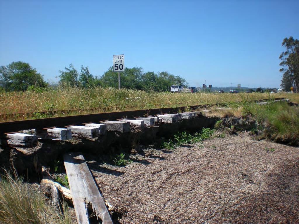
16 North Humboldt Bay SR 255 Railroad County Road SR Sea Level Rise - Building Resilient Infrastructure March 26, 2015

17

18
 (10.")
19 Shoreline Inventory and Mapping Total length of shoreline: 102 miles (open bays and sloughs) Artificial: 75% Natural: 25% (41 miles) (26 miles) (10.5 miles) Dike Natural Railroad Source: (Laird, 2013) 19 Sea Level Rise - Building Resilient Infrastructure March 26, 2015
20 Annual Maximum High Tides 10.5 North Spit Tide Gauge, feet 9 Water Level (feet NAVD88) Sea Level Rise - Building Resilient Infrastructure March 26, 2015
21 Extreme Storm Events Saturday, Dec. 31, :18 AM Predicted height: 8.1 feet Verified height: 9.55 feet 21 Sea Level Rise - Building Resilient Infrastructure March 26, 2015
22 December 31, Sea Level Rise - Building Resilient Infrastructure March 26, 2015

23 December 31, Sea Level Rise - Building Resilient Infrastructure March 26, 2015

24

25

26
 27 Sea Level Rise - Building Resilient Infrastructure March 26,")
27 Hydrodynamic Modeling Seamless topographic/bathymetric digital elevation model LiDAR plus various subtidal data sets Source: PWA (2014) 27 Sea Level Rise - Building Resilient Infrastructure March 26, 2015
 Configured as two-dimensional model (1,560 horizontal")


28 Hydrodynamic Modeling Environmental Fluid Dynamics Code (USEPA) Configured as two-dimensional model (1,560 horizontal cells) Forced by 100-year stationary hourly sea level height series at ocean boundary Accounts for astronomical tides, storm surge, barometric pressure, ENSO/PDO Source: NHE (2015) 28 Sea Level Rise - Building Resilient Infrastructure March 26, 2015
29 Sea Level Rise Scenarios for Modeling and Mapping Rise (Inches) m (79 inches) 1.5 m (59 inches) 1.0 m (39 inches) 0.5 m (20 inches) Source: NHE (2015) High Projection Medium Projection Low Projection Scenarios: 2012 and 0.5 meter increments relative to Year Sea Level Rise - Building Resilient Infrastructure March 26, 2015
30 Sea Level Rise Scenarios for Modeling and Mapping MHHW MMMW 16 MAMW 10-yr 100-yr Water Level (feet NAVD88) m SLR 1.0 m SLR Source: NHE (2015) 30 Sea Level Rise - Building Resilient Infrastructure March 26, 2015
31 Sea Level Rise Inundation Vulnerability Sea Level Rise - Building Resilient Infrastructure March 26, 2015

32 Sea Level Rise Inundation Vulnerability Sea Level Rise - Building Resilient Infrastructure March 26, 2015
33 Sea Level Rise Inundation Vulnerability Sea Level Rise - Building Resilient Infrastructure March 26, 2015
34 Sea Level Rise Inundation Vulnerability 2012 Mean Monthly Maximum Water Level 34 Sea Level Rise - Building Resilient Infrastructure March 26, 2015
35 Sea Level Rise Inundation Vulnerability 0.5 meters SLR Mean Monthly Maximum Water Level 35 Sea Level Rise - Building Resilient Infrastructure March 26, 2015

36 Sea Level Rise Inundation Vulnerability 1.0 meters SLR Mean Monthly Maximum Water Level 36 Sea Level Rise - Building Resilient Infrastructure March 26, 2015
37 Sea Level Rise Inundation Vulnerability 1.5 meters SLR Mean Monthly Maximum Water Level 37 Sea Level Rise - Building Resilient Infrastructure March 26, 2015
38 Sea Level Rise Inundation Vulnerability 2.0 meters SLR Mean Monthly Maximum Water Level 38 Sea Level Rise - Building Resilient Infrastructure March 26, 2015
39 Part 3: Risk Assessment 39 Sea Level Rise - Building Resilient Infrastructure March 26, 2015

40 Source: GHD, 2014
41 Sea Level Rise Inundation Vulnerability Mean Monthly Maximum Water Level SR meters SLR Eureka-Arcata Connections: High exposure Railroad Limited redundancy County Road Dependence on railroad (but no investment or maintenance of railroad for >20 years) SR 101 Caltrans has major role High risk / high importance 41 Sea Level Rise - Building Resilient Infrastructure March 26, 2015
42 Part 4: Adaptation Planning 42 Sea Level Rise - Building Resilient Infrastructure March 26, 2015
43 Part 4: Adaptation Planning Basic Approaches: 1. Protect (Defend) - Hard/Soft structures 2. Accommodate - Elevate (fill or causeway), and/or enhance drainage 3. Re-locate (Planned retreat) 4. No action wait and see - Repair damage - Closure / forced retreat 43 Sea Level Rise - Building Resilient Infrastructure March 26, 2015


44 Boat Launch Facility 44 Sea Level Rise - Building Resilient Infrastructure March 26, 2015


45 Boat Launch Facility Sea Level Rise - Building Resilient Infrastructure March 26, 2015

46 Storm Damage Erosion of Road Embankment New Navy Base Road PM Sea Level Rise - Building Resilient Infrastructure March 26, 2015


47 Storm Damage Erosion of Road Embankment Sea Level Rise - Building Resilient Infrastructure March 26, 2015

48 Storm Damage Erosion of Road Embankment December 26, Sea Level Rise - Building Resilient Infrastructure March 26, 2015
49 Storm Damage Erosion of Road Embankment December 29, Sea Level Rise - Building Resilient Infrastructure March 26, 2015

50 Storm Damage Erosion of Road Embankment Applied traditional hardened structure as emergency response Permanent Coastal Development Permit still pending 50 Sea Level Rise - Building Resilient Infrastructure March 26, 2015

51 Living Shoreline / Horizontal Levee 51 Sea Level Rise - Building Resilient Infrastructure March 26, 2015

52 Living Shoreline / Horizontal Levee 52 Sea Level Rise - Building Resilient Infrastructure March 26, 2015

53 Living Shoreline / Horizontal Levee Source: Alexander et al (2015) 53 Sea Level Rise - Building Resilient Infrastructure March 26, 2015


54 Levee around Reclaimed Tidelands (1) Ground elevation: 6 feet Levee crest elevation: 11 to 12 feet County vehicle maintenance facility is one of 31 parcels No single levee owner/manager Challenges: feasibility, funding, permitting, administration County is leading collaboration to do technical studies, exploring use of county-wide flood control district 54 Sea Level Rise - Building Resilient Infrastructure March 26, 2015


55 Levee around Reclaimed Tidelands (2) Breach in August 2014 at Humboldt Bay National Wildlife Refuge (White Slough, South Humboldt Bay) Flooded 50 acres intended for salt marsh restoration 55 Sea Level Rise - Building Resilient Infrastructure March 26, 2015

56 Small Bridge Project Design for freeboard Design abutments to facilitate future bridge raising Limiting factor: approach roads Pine Hill Road 56 Sea Level Rise - Building Resilient Infrastructure March 26, 2015


57 Major Corridor Projects SLR is key to permitting, facility longevity No prospect for planned retreat: must protect/accommodate Need to collaborate and take advantage of multi-benefit opportunities 57 Sea Level Rise - Building Resilient Infrastructure March 26, 2015

58 Conclusion: Needs and Opportunities for Sea Level Rise Adaptation Solid technical basis with common targets Regional collaboration Communication and integration Multi-benefit projects Permitting flexibility Pilot projects Federal/state investment 58 Sea Level Rise - Building Resilient Infrastructure March 26, 2015
Flood Damage Mitigation And Insurance Costs
 Flood Damage Mitigation And Insurance Costs Friday, September 25, 2015 at 7:00 PM Saturday, September 26, 2015 at 10:00 AM This presentation was prepared by the Town of South Bethany using Federal Funds
Flooding in San Francisco Bay: Risks and Opportunities
 Flooding in San Francisco Bay: Risks and Opportunities Photo Judy Irving Pelican Media Authors Jeffrey Mount, Saracino & Mount LLC Jeremy Lowe, ESA PWA Flooding in San Francisco Bay: Risks and Opportunities
An Initial Assessment of the Impacts of Sea Level Rise to the California Coast
 An Initial Assessment of the Impacts of Sea Level Rise to the California Coast Photo by D. Revell 2/23/08 California Coastal Records Project Dr. David Revell and Matt Heberger, P.E. Dr. Peter Gleick, Bob
ART Vulnerability and Risk Assessment Report September 2012 Appendix C. ART GIS Exposure Analysis
 Adapting to Rising Tides GIS Exposure Analysis The aim of this appendix is to familiarize the reader with the data and methodology that was used to conduct an analysis of shoreline and community asset
Oregon. Climate Change Adaptation Framework
 Oregon Climate Change Adaptation Framework Oregon Environmental Quality Commission Climate Change Adaptation Framework Presentation at a glance: Purposes of the framework Participating agencies Climate
POST-DISASTER REDEVELOPMENT PLANNING
 TABLE OF CONTENTS POST-DISASTER REDEVELOPMENT PLANNING Addressing Adaptation During Long-term Recovery Florida Department of Economic Opportunity Florida Division of Emergency Management page ii This report
LOCAL COASTAL PROGRAM PLANNING GRANTS JOINT APPLICATION ANNOUNCEMENT & INSTRUCTIONS APRIL 23, 2014
 LOCAL COASTAL PROGRAM PLANNING GRANTS JOINT APPLICATION ANNOUNCEMENT & INSTRUCTIONS APRIL 23, 2014 The State of California is pleased to announce grant funding for FY14-15 to support local governments
GUIDANCE FOR INCORPORATING SEA LEVEL RISE INTO CAPITAL PLANNING IN SAN FRANCISCO: ASSESSING VULNERABILITY, RISK, AND ADAPTATION (DRAFT)
") GUIDANCE FOR INCORPORATING SEA LEVEL RISE INTO CAPITAL PLANNING IN SAN FRANCISCO: ASSESSING VULNERABILITY, RISK, AND ADAPTATION (DRAFT) Prepared by the Sea Level Rise Committee of SF Adapt for the San
GUIDANCE FOR INCORPORATING SEA LEVEL RISE INTO CAPITAL PLANNING IN SAN FRANCISCO: ASSESSING VULNERABILITY, RISK, AND ADAPTATION (DRAFT) Prepared by the Sea Level Rise Committee of SF Adapt for the San
South Florida Sea Level Rise Projections and Flood Risk Concerns
 South Florida Sea Level Rise Projections and Flood Risk Concerns MIAMI MIAMI Biscayne Bay Glenn B. Landers, P.E. Planning and Policy Division Jacksonville District EVERGLADES NATIONAL PARK USACE Flood
Predicting Coastal Hazards: A Southern California Demonstration
 Predicting Coastal Hazards: A Southern California Demonstration Patrick Barnard United States Geological Survey Coastal and Marine Geology Team Santa Cruz, CA Southern California Multi-hazards Demonstration
Sea Level Change. Miami-Dade Sea Level Rise Task Force
 Sea Level Change and LongProgram Range Everglades Restoration Climate Water Resources Planning for Florida Change Application Concerns of USACE andguidance Draft Sea Level on Sea Rise Level Planning Change
Town of Chatham Department of Community Development
 Town of Chatham Department of Community Development TOWN ANNEX 261 GEORGE RYDER ROAD 02633 CHATHAM, MA TELEPHONE (508) 945-5168 FAX (508) 945-5163 FEMA FLOOD MAP UPDATE & PROPOSED ZONING BYLAW AMENDMENT
Sea Level Rise and Coastal Flood Web Tools Comparison Matrix - Oregon GENERAL
 Geographic Scope Organization/Sponsor Link Geographic extent the tool defines or covers (i.e. national, statewide, county ) The organization and/or sponsor of the mapping tool. The URL or link where the
San Francisco Bay Margin Conservation Decision Support System (DSS)
") San Francisco Bay Margin Conservation Decision Support System (DSS) Presented by Brian Fulfrost1, MS David Thomson2, MS 1 Brian Fulfrost and Associates 2 San Francisco Bay Bird Observatory Transitional
San Francisco Bay Margin Conservation Decision Support System (DSS) Presented by Brian Fulfrost1, MS David Thomson2, MS 1 Brian Fulfrost and Associates 2 San Francisco Bay Bird Observatory Transitional
ART Vulnerability and Risk Assessment Report
 ART Vulnerability and Risk Assessment Report September 2012 Chapter 1. Introduction to the ART Vulnerability and Risk Assessment The Adapting to Rising Tides (ART) project is a collaborative effort to
Community Engagement and Cost Benefit Analysis for Sea Level Rise and Storm Surge Adaptation
 Community Engagement and Cost Benefit Analysis for Sea Level Rise and Storm Surge Adaptation Methods, Case Studies, and Wetland-specific Opportunities Samuel B. Merrill, Ph.D. December 10, 2012 Muskie
Guideline: A risk assessment approach to development assessment in coastal hazard areas
 Guideline: A risk assessment approach to development assessment in coastal hazard areas Prepared by: Environment Planning, Department of Environment and Heritage Protection State of Queensland, 2013. The
San Francisco Bay Ecotone Conservation and Management Decision Support System (DSS)
") 1 San Francisco Bay Ecotone Conservation and Management Decision Support System (DSS) Performance Report (June 2015) submitted by Brian Fulfrost (MS) Geospatial Lead Brian Fulfrost and Associates bfaconsult@gmail.com
1 San Francisco Bay Ecotone Conservation and Management Decision Support System (DSS) Performance Report (June 2015) submitted by Brian Fulfrost (MS) Geospatial Lead Brian Fulfrost and Associates bfaconsult@gmail.com
Surviving the Storm Economic impacts of an acute flooding event in the Bay Area. Downtown San Anselmo. 2006 New Years Flood
 Surviving the Storm Economic impacts of an acute flooding event in the Bay Area. Downtown San Anselmo. 2006 New Years Flood Bay Area Council Water Committee: ABAG, BCDC, BART, SFO, Port of SF, Port of
Leveraging Resources for Financing, Implementing, and Sustaining Climate Change Adaptation and Resiliency
 Leveraging Resources for Financing, Implementing, and Sustaining Climate Change Adaptation and Resiliency August 20, 2014 California Adaptation Forum Karen Kubick, PE Sewer System Improvement Program Director
Climate Change in Coastal Florida: Economic Impacts of Sea Level Rise
 Climate Change in Coastal Florida: Economic Impacts of Sea Level Rise CLIMTE CHNGE IN COSTL FLORID: ECONOMIC IMPCTS OF SE LEVEL RISE Context Global warming is expected to cause: Sea level rise Increased
Screening Transportation Assets for Vulnerability
 Screening Transportation Assets for Vulnerability Impacts of Climate Change and Variability on Transportation Systems & Infrastructure (Gulf Coast Study, Phase 2) FHWA Office of Planning Environment and
Designing and Developing WebGIS SLR tools: NJ Floodmapper
 Designing and Developing WebGIS SLR tools: NJ Floodmapper Richard Lathrop, Lisa Auermuller, Jeanne Herb, Marjorie Kaplan, James Trimble, John Bognar & Jennifer Rovito Coastal Community Resiliency Progression
4.14 Netherlands. Interactive flood risk map of a part of the province of Gelderland in the Netherlands. Atlas of Flood Maps
 4.14 Netherlands The Netherlands is flood prone for about 60% of its surface. 95 so-called dike-rings protect the polders from being flooded from the North Sea, rivers or lakes. The protection level has
The success of the hurricane protection around Chevron s refinery at Pascagoula, MS, during Katrina
 The success of the hurricane protection around Chevron s refinery at Pascagoula, MS, during Katrina Dr J.W. van der Meer, Dr C. Cooper, M.J. Warner, H. Adams-Morales and G.J. Steendam Abstract and presentation
The project site lies within an AE Zone and portions lie within the regulated floodway. Development of this site is subject to TCLUO, Section 3.060.
 Introduction This application is for the Southern Flow Corridor-Landowner Preferred Alternative, a flood mitigation and tidal wetland restoration project. The Port of Tillamook Bay is the applicant in
SOUTHWEST FLORIDA PLANS FOR CHANGE
 SOUTHWEST FLORIDA PLANS FOR CHANGE James W. Beever III, Whitney Gray, Moji Abimbola, Dan Cobb, John Gibbons, Dave Hutchinson, Dan Trescott, Jason Utley from SWFRPC, and Lisa Beever and Judy Ott from CHNEP
Design And Construction Of The South San Diego Bay Western Salt Pond Restoration Project. 2012 Headwaters To Ocean Conference
 Design And Construction Of The South San Diego Bay Western Salt Pond Restoration Project 2012 Headwaters To Ocean Conference David Cannon, M.C.E., P.E. President/Principal Engineer Everest International
A Paper From: California Climate Change Center
 THE IMPACTS OF SEA-LEVEL RISE ON THE CALIFORNIA COAST A Paper From: California Climate Change Center Prepared By: Matthew Heberger, Heather Cooley, Pablo Herrera, Peter H. Gleick, and Eli Moore of the
ECONOMIC ANALYSIS FLOOD DAMAGE REDUCTION. Lower Carmel River Floodplain Restoration and Enhancement Project
 ECONOMIC ANALYSIS FLOOD DAMAGE REDUCTION Lower Carmel River Floodplain Restoration and Enhancement Project I. Description of the Project and its Relationship to Other Projects in the Proposal The Lower
Storm Surges in Denmark:
 Storm Surges in Denmark: Past experiences and expectations for the future Carlo Sorensen Carl-Christian Munk-Nielsen Thorsten Piontkowitz Danish Coastal Authority, DK-7620 Lemvig, Denmark. www.kyst.dk
Federal Emergency Management Agency (FEMA) Preliminary Flood Insurance Rate Maps (FIRMs) and Preliminary Flood Insurance Study (FIS) for New York City
 Preliminary Flood Insurance Rate Maps (FIRMs) and Preliminary Flood Insurance Study (FIS) for New York City") March 10, 2014 Submitted electronically via http://www.nyc.gov Mayor s Office of Long Term Planning and Sustainability c/o Flood Map Comments 253 Broadway, 10th Floor New York, NY 10007 Federal Emergency
March 10, 2014 Submitted electronically via http://www.nyc.gov Mayor s Office of Long Term Planning and Sustainability c/o Flood Map Comments 253 Broadway, 10th Floor New York, NY 10007 Federal Emergency
Flood Risk Management
 Flood Risk Management Value of Flood Risk Management Every year floods sweep through communities across the United States taking lives, destroying property, shutting down businesses, harming the environment
Flood Risk Management
 Flood Risk Management Value of Flood Risk Management Value to Individuals and Communities Every year floods sweep through communities across the United States taking lives, destroying property, shutting
FLOOD HAZARD IN THE URBAN ENVIRONMENT: IMPLICATIONS FOR DEVELOPERS, DESIGNERS, AND ATTORNEYS
 FLOOD HAZARD IN THE URBAN ENVIRONMENT: IMPLICATIONS FOR DEVELOPERS, DESIGNERS, AND ATTORNEYS PRESENTED BY: CHAD W. COX, P.E. DANIEL C. STAPLETON, P.E. BOSTON, MA JAN. 24, 2014 PRESENTATION Flood Vulnerability
with Climate Change Risk: MWCOG Climate Impacts Symposium May 21, 2012
 Storm Sewer Infrastructure Planning with Climate Change Risk: A Case Study from Alexandria VA Laurens van der Tak, PE, D.WRE MWCOG Climate Impacts Symposium May 21, 2012 Presentation Topics Overview of
Miami-Dade County Roadmap for Adapting to Coastal Risk
 Miami-Dade County Roadmap for Adapting to Coastal Risk Vulnerability Assessment & Planning Workshop Results & Recommendations Roadmap for Adapting to Coastal Risk Page 1 Introduction GreenPrint is Miami-Dade
SECTOR ASSESSMENT (SUMMARY): CLIMATE CHANGE. 1. Sector Performance, Problems, and Opportunities
: CLIMATE CHANGE. 1. Sector Performance, Problems, and Opportunities") Climate Resilience Sector Project (RRP TON 46351) Sector Road Map SECTOR ASSESSMENT (SUMMARY): CLIMATE CHANGE 1. Sector Performance, Problems, and Opportunities 1. Tonga is being affected by climate change,
Climate Resilience Sector Project (RRP TON 46351) Sector Road Map SECTOR ASSESSMENT (SUMMARY): CLIMATE CHANGE 1. Sector Performance, Problems, and Opportunities 1. Tonga is being affected by climate change,
Floodplain Development Land Use Review
 COMMUNITY DEVELOPMENT DEPARTMENT Planning Division P.O. Box 490 333 Broadalbin Street SW Albany, OR 97321 Phone 541-917-7550 Fax 541-791-0150 www.cityofalbany.net Floodplain Development Land Use Review
Impacts of Global Warming on North Carolina s Coastal Economy
 Impacts of Global Warming on North Carolina s Coastal Economy IMPACTS OF GLOBAL WARMING ON NORTH CAROLINA S COASTAL ECONOMY Key Findings Global warming is projected to have significant impacts on North
AN INITIATIVE TO IMPROVE
 L OW E R C A R M E L R I V E R A N D L AG O O N F L O O D P L A I N R E S TO R AT I O N A N D E N H A N C E M E N T P R O J E C T AN INITIATIVE TO IMPROVE FLOOD PROTECTION RESTORE AND PROTECT RIPARIAN
Flood Emergency Response Planning: How to Protect Your Business from a Natural Disaster RIC005
 Flood Emergency Response Planning: How to Protect Your Business from a Natural Disaster RIC005 Speakers: Tom Chan, CEO, Global Risk Miyamoto Greg Bates, Principal, Global Risk Consultants Learning Objectives
Mariana Leckner, Ph.D., Professor, American Military University Thomas O. Herrington, Ph.D. Associate Professor, Stevens Institute of Technology
 Mariana Leckner, Ph.D., Professor, American Military University Thomas O. Herrington, Ph.D. Associate Professor, Stevens Institute of Technology National Hydrologic Warning Council Training Conference
SITE INVESTIGATIONS OF THE BEACH EROSION PROBLEM AT MAHO BEACH, ST. MAARTEN
 SITE INVESTIGATIONS OF THE BEACH EROSION PROBLEM AT MAHO BEACH, ST. MAARTEN Performed February 2003 Performed by: Dr. Lee E. Harris, Ph.D., P.E. Associate Professor of Ocean Engineering & Oceanography
Why should communities invest in resiliency? What are the steps communities can take to become more resilient?
 Community Preparedness for Flood Resiliency Nina Peek, AICP New York Planning Federation Board of Directors Senior Technical Director AKRF, Inc. Focus of Today s Presentation Why should communities invest
Impacts of Sea-Level Rise on National Wildlife Refuges
 Impacts of Sea-Level Rise on National Wildlife Refuges Considerations for Land Protection Priorities Photo: National Oceanic and Atmospheric Administration O ne of the well-documented impacts of climate
Control filling, grading, dredging, and other development which may increase erosion or flood damage; and
 ARTICLE 16. FLOOD DAMAGE PREVENTION Section 16-1: Findings of Fact The flood hazard areas of the Town of Lillington are subject to periodic inundation which results in loss of life and property, health
COASTAL DEVELOPMENT PERMIT
 COASTAL DEVELOPMENT PERMIT ZONE CODE SECTIONS 12.20.2 prior to LCP certification. The MASTER LAND USE APPLICATION INSTRUCTION SHEET 500' RADIUS should also be followed, except that a 100-foot radius map
Evaluating the Condition of Seawalls/Bulkheads
 Volume 2 Evaluating the Condition of Seawalls/Bulkheads By: Coastal Systems International, Inc. Typical bulkhead under construction Seawalls and bulkheads (walls) provide shoreline stabilization for many
New Brunswick s Flood Risk Reduction Strategy. Province of New Brunswick PO 6000, Fredericton NB E3B 5H1. www.gnb.ca
 New Brunswick s Flood Risk Reduction Strategy i New Brunswick s Flood Risk Reduction Strategy Province of New Brunswick PO 6000, Fredericton NB E3B 5H1 2014 www.gnb.ca ISBN 978-1-4605-0533-5 (print edition)
FLOOD CONTROL (Zone 4 Lines A and E)
") FLOOD CONTROL (Zone 4 Lines A and E) Asset Description: The Hayward Resilience Study area is within Alameda County Flood Control Water Conservation District (ACFCWCD) Zone 4, a 4.6 square-mile zone extending
FLOOD CONTROL (Zone 4 Lines A and E) Asset Description: The Hayward Resilience Study area is within Alameda County Flood Control Water Conservation District (ACFCWCD) Zone 4, a 4.6 square-mile zone extending
ebb current, the velocity alternately increasing and decreasing without coming to
 Slack water (slack tide): The state of a tidal current when its velocity is near zero, especially the moment when a reversing current changes its direction and its velocity is zero. The term is also applied
Impacts of Global Warming on Hurricane-related Flooding in Corpus Christi,Texas
 Impacts of Global Warming on Hurricane-related Flooding in Corpus Christi,Texas Sea-level Rise and Flood Elevation A one-foot rise in flood elevation due to both sea-level rise and hurricane intensification
CLACKAMAS COUNTY ZONING AND DEVELOPMENT ORDINANCE
 1008 STORM DRAINAGE (3/24/05) 1008.01 PURPOSE To minimize the amount of stormwater runoff resulting from development utilizing nonstructural controls where possible, maintain and improve water quality,
Post-Flood Assessment
 Page 1 of 7 Post-Flood Assessment CHAPTER 4 AGENCY COORDINATION Agency coordination is an essential element for the operation of the flood management systems in the Central Valley. Due to the nature of
APPENDIX G. California Coastal Commission & Conservancy Accessibility Standards
 APPENDIX G California Coastal Commission & Conservancy Accessibility Standards STANDARDS AND RECOMMENDATIONS FOR ACCESSWAY LOCATION AND DEVELOPMENT These standards provide guidelines for the location,
Using Insurance Catastrophe Models to Investigate the Economics of Climate Change Impacts and Adaptation
 Using Insurance Catastrophe Models to Investigate the Economics of Climate Change Impacts and Adaptation Dr Nicola Patmore Senior Research Analyst Risk Management Solutions (RMS) Bringing Science to the
Why does Kittitas County want to form a Flood Control Zone District?
 KITTITAS COUNTY DEPARTMENT OF PUBLIC WORKS Kirk Holmes, Director What is a Flood Control Zone District (FCZD)? A Kittitas County Flood Control Zone District (FCZD) would be a special-purpose government
KEYPORT COMMUNITY PLAN
 PLANNING COMMISSION TASKS Collect Public Comments on Draft Plan. Provide Clear Direction for: Preferred LAMIRD Boundary Lot Clustering Provision View Protection Recommendation to Board of County Commissioners.
Ariana Sutton-Grier, Holly Bamford & Kateryna Wowk University of Maryland and National Oceanic and Atmospheric Administration
 Future of our coasts: Potential for natural and hybrid infrastructure Ariana Sutton-Grier, Holly Bamford & Kateryna Wowk University of Maryland and National Oceanic and Atmospheric Administration Green
The Basics of Chapter 105 Waterways and Wetlands Permitting in PA
 The Basics of Chapter 105 Waterways and Wetlands Permitting in PA April 17, 2013 Goal To develop a basic understanding of PA Department of Environmental Protection (DEP) and US Army Corps of Engineers
Tuesday May 26, 2015 Morning Program
 Tuesday May 26, 2015 Morning Program 8:00-5:00 Registration (Lobby/Exhibitor Area) 9:30-10:00 Welcome And Opening Remarks Steven Aceti, J.D., Executive Director, California Coastal Coalition Mayor Mark
Vulnerability of Major Wastewater Facilities to Flooding from Sea-Level Rise. July 2008
 Vulnerability of Major Wastewater Facilities to Flooding from Sea-Level Rise July 2008 King County's Wastewater Treatment Division maintains 77 major facilities, 40 of which are situated adjacent to tidally
PREVENTION. City of Orem FLOOD DAMAGE PREVENTION 10-1-1
 City of Orem FLOOD DAMAGE PREVENTION 10-1-1 CHAPTER 10. Article 10-1. Article 10-2. Article 10-3. Article 10-4. Article 10-5. FLOOD DAMAGE PREVENTION Purposes Definitions General Provisions Administration
Preparing for Tomorrow s High Tide. Recommendations for Adapting to Sea Level Rise in Delaware
 Preparing for Tomorrow s High Tide Recommendations for Adapting to Sea Level Rise in Delaware September 2013 About this Document This document was developed by Delaware s Sea Level Rise Advisory Committee
10. Infrastructure and the Built Environment
 151 152 10. Infrastructure and the Built Environment Maintaining safe and reliable infrastructure is critical for Washington s economy, environment, and way of life. This chapter addresses climate impacts
AASHTO 2015 EXTREME WEATHER SESSIONS
 AASHTO 2015 EXTREME WEATHER SESSIONS AASHTO S CONFERENCE ON 21ST CENTURY MOBILITY FOR FREIGHT AND PASSENGER TRANSPORTATION BREAKOUT 6: FLOODING, VULNERABILITY AND RISK, OH MY! JULY 8, 2015 4:00 5:30 PM
Lower Breton Sound Sediment Diversion Conceptual Engineering Design Presentation
 EXPERT PANEL ON DIVERSION PLANNING AND IMPLEMENTATION Lower Breton Sound Sediment Diversion Conceptual Engineering Design Presentation February 12, 2015 Topics I. Introduction II. Geotechnical Study III.
FINAL TECHNICAL MEMORANDUM AWD-00002 FLOWS THROUGH FLOOD DAMAGE REDUCTION AREA July 16, 2012
 FINAL TECHNICAL MEMORANDUM AWD-00002 FLOWS THROUGH FLOOD DAMAGE REDUCTION AREA July 16, 2012 Table of Contents TABLE OF CONTENTS Table of Contents... 1 Executive Summary... 2 1 Objective... 4 2 Study Approach...
Climate Change Long Term Trends and their Implications for Emergency Management August 2011
 Climate Change Long Term Trends and their Implications for Emergency Management August 2011 Overview A significant amount of existing research indicates that the world s climate is changing. Emergency
In Coastal Virginia, flooding
 Fall 2012, Vol. 7, No. 2 In Coastal Virginia, flooding has been an on-going issue. Flooding is caused by precipitation events, high tides or storm surge. Although flooding has occurred throughout recorded
Planning Policy and Guidance on Flooding and Coastal Erosion
 Planning Policy and Guidance on Flooding and Coastal Erosion James Hooker (MRTPI) Senior Planning Manager Welsh Government RTPI Cymru - Water and Flooding Seminar Tuesday 20 th November 2012 Overview
annual shoreline erosion rate until the time when erosion rate Section 205A-2, Hawaii Revised Statutes, is
 THE SENATE TWENTY-EIGHTH LEGISLATURE, STATE OF HAWAII JAN S.B. NO.- A BILL FOR AN ACT RELATING TO COASTAL ZONE MANAGEMENT. BE IT ENACTED BY THE LEGISLATURE OF THE STATE OF HAWAII: SECTION. The legislature
Geospatial Positioning Accuracy Standards Part 2: Standards for Geodetic Networks
 Geospatial Positioning Accuracy Standards Federal Geodetic Control Subcommittee Federal Geographic Data Committee Federal Geographic Data Committee Department of Agriculture Department of Commerce Department
Updated Federal Emergency Management Agency Flood Insurance Rate Maps and Zoning Ordinance Update. July 16, 2015 Policy Committee
 Updated Federal Emergency Management Agency Flood Insurance Rate Maps and Zoning Ordinance Update July 16, 2015 Policy Committee FEMA Map Update Costal Analysis and mapping study by FEMA in 2009 Changes
Package Treatment Plant Policy and Procedure
 Package Treatment Plant Policy and Procedure PURPOSE There has been increased interest in the use of package treatment plants for new development proposals in the County. Current review procedures are
Resource Management Accomplishments FY 2014
 Resource Management Accomplishments FY 2014 Sea turtle nest protection - Over 3,700 sea turtle nests were covered with wire mesh screens to protect them from being predated. Data on each sea turtle activity
Bolinas Lagoon Ecosystem Restoration Feasibility Project Marin County Open Space District
 Bolinas Lagoon Ecosystem Restoration Feasibility Project Marin County Open Space District With Funding from the California State Coastal Conservancy & the U.S. Army Corps of Engineers July 2006 Bolinas
3. The submittal shall include a proposed scope of work to confirm the provided project description;
 QIN Shoreline Master Program Project Summary The Shoreline Master Program (SMP) development process for the Quinault Indian Nation (QIN) includes the completion of inventory and analysis report with corresponding
Interpreting Federal Emergency Management Agency Flood Maps and Studies in the Coastal Zone
 Interpreting Federal Emergency Management Agency Flood Maps and Studies in the Coastal Zone Publication Date: October 2015 Table of Contents FEMA Flood Insurance Rate Maps and Flood Insurance Studies.
Adaptation for City Infrastructure; A Case Study of East Boston, MA
 Adaptation for City Infrastructure; A Case Study of East Boston, MA Paul Kirshen and Thomas Ballestero with support from Kirk Bosma, Wood Hole Group EMF, July 22, 2014 Funded by SARP, OGP, US NOAA Climate
Pete Slovinsky, Coastal Geologist, Maine Dept. of Agriculture, Conservation and Forestry
 MEGUG WINTER MEETING AGENDA FEB 2 ND, USM WISHCAMPER CENTER PORTLAND, ME 8:30 9:30am Registration and Poster Setup. Coffee, Tea, and Pastry served. 9:30 10am Opening Remarks, Announcements, and Updates
Impacts of Sea Level Rise on Florida s Domestic Energy and Water Infrastructure Dr. Leonard Berry s Testimony
 Impacts of Sea Level Rise on Florida s Domestic Energy and Water Infrastructure Dr. Leonard Berry s Testimony To The United States Senate Committee on Energy and Natural Resources April 19th, 2012 Washington
A9. Flood Damage Reduction
 A9. Flood Damage Reduction Attachment 9 identifies the flood damage reduction benefits attributed to the seven projects proposed for implementation in the Santa Barbara County Region Proposition 84 (Prop
October 15, 2013. Mayor and Council City of New Westminster 511 Royal Avenue New Westminster, BC V3L 1H9
 October 15, 2013 Mayor and Council City of New Westminster 511 Royal Avenue New Westminster, BC V3L 1H9 RE: Business Plan Advancing a Collaborative, Regional Approach to Flood Management in BC s Lower
Little Lake Shoreline Protection & Marsh Creation Project BA-37
 Little Lake Shoreline Protection & Marsh Creation Project BA-37 SCI PROJECT NO. 116478 POST CONSTRUCTION SURVEY REPORT AUGUST 2007 Prepared for: Louisiana Department of Natural Resources Prepared By: Shaw
Climate Change and Infrastructure Planning Ahead
 Climate Change and Infrastructure Planning Ahead Climate Change and Infrastructure Planning Ahead Infrastructure the physical facilities that support our society, such as buildings, roads, railways, ports
United States Postal Service Climate Change Adaptation Plan
 United States Postal Service Climate Change Adaptation Plan Version: June 29, 2012 USPS Climate Change Adaptation Plan 1. Introduction...2 2. Policy Framework...3 Vision & Goals...3 Objectives...3 Responsible
Final Project Wastewater Treatment Facility
 HUMBOLDT STATE UNIVERSITY GEOSPATIAL STUDIES GSP 270 - INTRODUCTION TO GIS Final Project Wastewater Treatment Facility Camila Ribeiro Matos Jéssica Sangiorgi Ricardo Jordan Adair Arcata - CA December 2014
NOTICE OF PREPARATION
 PLANNING DIVISION CITY OF SUNNYVALE P.O. BOX 3707 SUNNYVALE, CA 94088-3707 NOTICE OF PREPARATION TO: Responsible, Trustee, and Other Interested Public Agencies FROM: Sunnyvale Community Development 456
Malcolm L. Spaulding Professor Emeritus, Ocean Engineering University of Rhode Island Narragansett, RI 02881
 Malcolm L. Spaulding Professor Emeritus, Ocean Engineering University of Rhode Island Narragansett, RI 02881 USACE Coastal and Hydraulics Laboratory(CHL) Data Infrastructure Workshop January 23, 2014 Overview
Imagine the result. San Mateo County Vulnerability Assessment. Report on Asset Categorization and Classification
 Imagine the result San Mateo County Vulnerability Assessment September 22, 2015 Table of Contents 1. Introduction 1 1.1 Purpose 2 1.2 Definitions and Background 2 2. Approach to Asset 5 2.1 Built Assets.
Reality Check: Climate Adaptation on the Ground in Miami-Dade County
 Reality Check: Climate Adaptation on the Ground in Miami-Dade County 1st World Congress on Cities and Adaptation to Climate Change Bonn, Germany Saturday, May 28th 30th, 2010 1:30 PM 3:30 PM Honorable
SECTION 1.0 STATUTORY AUTHORIZATION AND PURPOSE
 A local law for Flood Damage Prevention as authorized by the New York State Constitution, Article IX, Section 2, and Environmental Conservation Law, Article 36 1.1 FINDINGS SECTION 1.0 STATUTORY AUTHORIZATION
Flood Insurance Guide THE INSURANCE AGENT S ROLE IN PROTECTING HOMEOWNERS
 Flood Insurance Guide THE INSURANCE AGENT S ROLE IN PROTECTING HOMEOWNERS Table of Contents Introduction... 3 Your Clients Need Flood Insurance... 5 For Most of the U.S., Flood Insurance Is Highly Affordable...
CLIMATE RISK MANAGEMENT IN ADB PROJECTS
 4. Identification of Adaptation Options The most viable adaptation options or climateproofing measures are identified in consultation with the executing agencies or project sponsors, and are integrated
Pine Creek Culvert Upgrade $ 560,000. Located at exiting hump dike, just south of Fire Training Center
 To: BOS From: Joseph Michelangelo, P.E. Director of Public Works Re: CDBG-DR Pine Creek Culvert Upgrade Date: April 20, 2015 On June 19, 2014, the Town of Fairfield was awarded the above referenced project
Small Dam Hazard Assessment Inventory
 Small Dam Hazard Assessment Inventory What would happen if your dam were to fail? This is a question that most dam owners hope they will never have to answer. However it is a question you, as a responsible
ARTICLE VII COUNTY FLOOD DAMAGE PREVENTION OVERLAY DISTRICT
 AMENDED IN ITS ENTIRETY ON OCTOBER 9, 2006 BY RESOLUTION NO. 06/10/94 AMENDED ON MARCH 16, 2009 BY RESOLUTION NO. 09/03/160 AMENDED IN ITS ENTIRETY ON DECEMBER 15, 2014 BY RESOLUTION NO. 14/12/300 ARTICLE
HUDSON RIVER-BLACK RIVER REGULATING DISTRICT BOARD MEETING JUNE 10, 2014
 HUDSON RIVER-BLACK RIVER REGULATING DISTRICT BOARD MEETING JUNE 10, 2014 PRESENTATION TOPICS Analysis Objectives Analysis Dam Removal Plan Dam Remediation Plan Effects Analysis Permit Requirements Decision