Little Lake Shoreline Protection & Marsh Creation Project BA-37
|
|
|
- Amice Chase
- 8 years ago
- Views:
Transcription
1 Little Lake Shoreline Protection & Marsh Creation Project BA-37 SCI PROJECT NO POST CONSTRUCTION SURVEY REPORT AUGUST 2007 Prepared for: Louisiana Department of Natural Resources Prepared By: Shaw Coastal, Inc. 197 Elysian Drive Houma, Louisiana 70363

2 SURVEY REPORT TABLE OF CONTENTS Section 1 Methodology Report...Page 1 Section 2 Drawing Files...Page 4 Section 3 Survey Data...Page 5 Section 4 Field Notes...Page 6 List of Appendices A B C Secondary Monument Data Sheet Survey Report and Data (CD-ROM) Land Surveyor s Certification

3 Section 1 Methodology Report

4 SECTION 1 METHODOLOGY REPORT DESCRIPTION This report details the procedures followed by Shaw Coastal Inc. to provide the Louisiana Department of Natural Resources, Coastal Restoration Division (LDNR/CRD) with required monitoring data to measure the elevation changes related to the marsh creation areas for the Little Lake Shoreline Protection/Dedicated Dredging Near Round Lake project (BA-37). Services include an elevation survey along pre-determined transects to determine marsh elevations. LOCATION The Little Lake Shoreline Protection / Dedicated Dredging near Round Lake Project (BA-37) is a shoreline protection and marsh creation project located in the central Barataria Basin in Lafourche Parish, Louisiana. The Little Lake Shoreline Protection project area is located on the southwestern shoreline of Little Lake from Superior Canal to Plume Point. The Little Lake project area is generally bound by the East and West Forks of Bayou L Ours and the southern shoreline of Little Lake from Plum Point westward to Breton Canal. The site is accessible only by boat. The nearest boat launch is the Clovelly Farms on Clovelly Canal located in Cut Off, Louisiana. The purpose of the project is to prevent erosion along approximately four (4) miles of Little Lake shoreline; create 488 acres of intertidal wetlands along the Little Lake shoreline; nourish and maintain 532 acres of intermediate marsh; and reduce the land-loss rates by 50% over the 20-year life of the project. The project consists of constructing a shoreline protection rock dike in open water along the shoreline of Little Lake and using dredged material from Little Lake to create/nourish intertidal marsh along the Little Lake shoreline. The project is sponsored by the United States Department of Commerce / National Ocean and Atmospheric Administration (NOAA) National Marine Fisheries Services (NMFS) and the Louisiana Department of Natural Resources (LDNR) under the Coastal Wetlands Planning, Protection, and Restoration Act (CWPPRA). PLANNING AND LAYOUT OF THE GPS SURVEY This scope of services involves the completion of a topographic survey along predetermined transects inside the Little Lake project (BA-37). The survey will provide data used to calculate elevation changes within the marsh creation areas. Page 1
 is a shoreline protection and marsh creation project located in the central Barataria Basin in")
5 TOPOGRAPHIC SURVEYS The points were surveyed utilizing Real Time Kinematic (RTK) surveying techniques. This survey will be referenced to the LDNR Louisiana Coastal Zone (LCZ) GPS Network. The LCZ Secondary Monuments to be used as the GPS reference station for this project is the BA-37-SM-01 and BA- 37-SM-02 monuments. The latest summary sheet showing the most recent adjusted position and elevation for these monuments are in Appendix A. The equipment that was used on this project was a Trimble 5700 RTK base station with a Trimble 5800 rover unit. The data was collected and stored on a Trimble TS Cell data collector. All survey data was recorded in LSZ NAD 83 feet (coordinates) and NAVD 88 feet (elevations). On a daily basis the RTK base station was setup over a TBM (pt. no. 3) the base station used a fixed antennae height. Then the TBM and setup were then checked against a secondary monument prior to gathering data and again immediately after. At the end of each day the data was downloaded and processed through TGO (Trimble Geomatics Office) software. Once the survey data was downloaded into TGO and processed it was then exported to Land Development software. Points were collected along predetermined transect lines and point locations as shown on the attached drawing (3 of 11). QUALITY ASSURANCE PROCEDURES Two LDNR LCZ monuments (BA-37-SM-01 and BA-37-SM-02) were used for the surveys. These monuments were used as checks on a daily basis for RTK surveys. Page 2

6 Section 2 Drawing Files

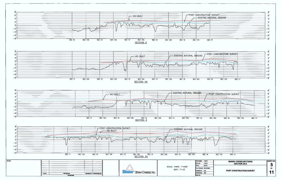
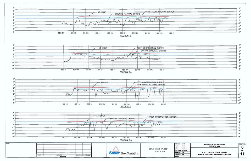
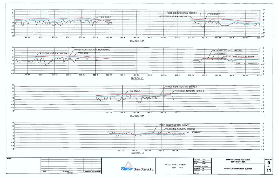
7 SECTION 2 DRAWING FILES Attached are eleven (11) drawing sheets created for the project area with all transects and elevation shots clearly labeled and plotted using the coordinates. On the plan view, the coordinate system that the drawing is referenced is the Louisiana State Plane Coordinates, South Zone, and the North American Datum of 1983 (NAD 83) in feet. Elevations are referenced to the North American Vertical Datum of 1988 (NAVD 88) in feet. Page 3
 in feet.")
8

9

10

11

12
13
14

15

16
17

18

19 Section 3 Survey Data

20 SECTION 3 SURVEY DATA A hard copy of the Survey data is attached. One (1) data file is produced in attached sheets: 1. Survey Data 9 Month Post Construction.xls One file will contain survey data reported in Louisiana State Plane Coordinates, South Zone in feet with NAVD 88 elevations in feet. Page 5

21
22
23
24
25
26 Section 4 Field Notes
27 SECTION 4 FIELD NOTES All field survey information documented and recorded is attached. Page 6
28
29
30
31
32
33
34
35
36
37
38
39
40
41
42
43
44
45
46
47
48
49
50
51
52 Appendix A Secondary Monument Data Sheet
53
54
55 Appendix B Survey Report and Data (CD-ROM)
56 Appendix C Land Surveyor s Certificate
57
2011 Operations, Maintenance, Monitoring and Rehabilitation Plan
 State of Louisiana Coastal Protection and Restoration Authority of Louisiana 2011 Operations, Maintenance, Monitoring and Rehabilitation Plan for East Marsh Island Marsh Creation State Project Number TV-21
CHAPTER 3 PROJECT CONTROL
 CHAPTER 3 PROJECT CONTROL Marking Survey Control Points 3-2 Horizontal Control 3-2 Vertical Control 3-3 Preconstruction Bench Marks 3-3 Bench Mark Levels 3-3 Bench Mark Check Levels 3-5 Total Station Leveling
Brevard County Public Works Finance and Contracts Administration
 Brevard County Public Works Finance and Contracts Administration Public Works Survey & Mapping Division Review Check Sheet for Land Acquisition, Drainage, Roadway and Pedway Expansion, Asbuilts, Maintenance
Coastwide Reference Monitoring System Wetlands (CRMS-Wetlands) Project Update
 Project Update") Coastwide Reference Monitoring System Wetlands (CRMS-Wetlands) Project Update Louisiana Department of Natural Resources Coastal Restoration Division U.S. Geological Survey National Wetlands Research Center
Coastwide Reference Monitoring System Wetlands (CRMS-Wetlands) Project Update Louisiana Department of Natural Resources Coastal Restoration Division U.S. Geological Survey National Wetlands Research Center
2011 Annual Inspection Report
 State of Louisiana Office of Coastal Protection and Restoration 2011 Annual Inspection Report for TERREBONNE BAY SHORE PROTECTION DEMONSTRATION State Project Number TE45 Priority Project List 10 February
Instructions for the Coastal Zone Management Act Federal Consistency Form
 COMMONWEALTH OF PENNSYLVANIA DEPARTMENT OF ENVIRONMENTAL PROTECTION INTERSTATE WATERS OFFICE BACKGROUND Introduction Remove and recycle these instructions prior to sending the completed form to DEP. for
MONITORING STANDARDS FOR BEACH EROSION CONTROL PROJECTS
 MONITORING STANDARDS FOR BEACH EROSION CONTROL PROJECTS May 2014 Edited: October 2014 Division of Water Resource Management Department of Environmental Protection State of Florida MONITORING STANDARDS
Hydrographic Survey of the Keith Lake-Salt Bayou System
 Hydrographic Survey of the Keith Lake-Salt Bayou System April 2007 Survey Prepared by: The Texas Water Development Board December 2007 Texas Water Development Board J. Kevin Ward, Executive Administrator
CHAPTER 9 SURVEYING TERMS AND ABBREVIATIONS
 CHAPTER 9 SURVEYING TERMS AND ABBREVIATIONS Surveying Terms 9-2 Standard Abbreviations 9-6 9-1 A) SURVEYING TERMS Accuracy - The degree of conformity with a standard, or the degree of perfection attained
STATE OF ALASKA DEPARTMENT OF NATURAL RESOURCES DIVISION OF MINING, LAND AND WATER. GENERAL SURVEY INSTRUCTIONS EASEMENTS Authority 11 AAC 53
 STATE OF ALASKA DEPARTMENT OF NATURAL RESOURCES DIVISION OF MINING, LAND AND WATER GENERAL SURVEY INSTRUCTIONS EASEMENTS Authority 11 AAC 53 These instructions define the survey and platting criteria unique
Earth Coordinates & Grid Coordinate Systems
 Earth Coordinates & Grid Coordinate Systems How do we model the earth? Datums Datums mathematically describe the surface of the Earth. Accounts for mean sea level, topography, and gravity models. Projections
Trimble R8 Base and Rover Quick Setup Guide. Inland GPS Inc.
 Trimble R8 Base and Rover Quick Setup Guide Inland GPS Inc. Setting up the GPS Base Equipment Hardware First Find the best, most advantageous secure place to setup the GPS base equipment. Look for a high
FINAL Environmental Impact Statement (EIS) for the
 for the") FINAL Environmental Impact Statement (EIS) for the Mississippi River-Gulf Outlet (MRGO), Louisiana, and Lake Borgne Wetland Creation and Shoreline Protection Project U.S. Army Corps of Engineers New Orleans
FINAL Environmental Impact Statement (EIS) for the Mississippi River-Gulf Outlet (MRGO), Louisiana, and Lake Borgne Wetland Creation and Shoreline Protection Project U.S. Army Corps of Engineers New Orleans
Design And Construction Of The South San Diego Bay Western Salt Pond Restoration Project. 2012 Headwaters To Ocean Conference
 Design And Construction Of The South San Diego Bay Western Salt Pond Restoration Project 2012 Headwaters To Ocean Conference David Cannon, M.C.E., P.E. President/Principal Engineer Everest International
Deepwater Horizon Oil Spill Phase I Early Restoration Plan and Environmental Assessment
 Deepwater Horizon Oil Spill Phase I Early Restoration Plan and Environmental Assessment Prepared by the Deepwater Horizon Natural Resource Trustees from State of Alabama State of Florida State of Louisiana
Request for Proposals for Topographic Mapping. Issued by: Teton County GIS and Teton County Engineering Teton County, Wyoming
 Request for Proposals for Topographic Mapping Issued by: Teton County GIS and Teton County Engineering Teton County, Wyoming Proposals due: 2:00PM MDT July 1, 2015 Proposals may be delivered to: Teton
FORESIGHT LAND SURVEYING, INC. 410 N. Sugar Street Brownstown, IN 47220 Phone: 812-358-4170 Fax: 812-358-4192
 FORESIGHT LAND SURVEYING, INC. 410 N. Sugar Street Brownstown, IN 47220 Phone: 812-358-4170 Fax: 812-358-4192 Mining Services: Boundary Surveys Topographic Surveys Volume Surveys Mine Mapping Surface &
Weekend Cabin Retreat Project Site Plans
 Weekend Cabin Retreat Project Site Plans Sacramento City College EDT 300/ENGR 306 EDT 300/ENGR 306 - Site Plans 1 Cabin Project Site Plan/Bubble Diagram - Assignment 1 =10-0 Floor Plan - Assignment 1/4
Most informed people realize that cumulative impacts have had
 Welcome to the First Issue of Rivers & Coast! The goal of the new Rivers & Coast newsletter is to keep readers well informed of current scientific understanding behind key environmental issues related
Coastal Restoration Spending in Louisiana Economic Impact Analysis
 Coastal Restoration Spending in Louisiana Economic Impact Analysis Louisiana Workforce Commission www.lmi.laworks.net/green September 2011 In 2009, Louisiana and Mississippi partnered to research economic
CWPPRA PPL 25 Nominee Voting Results
 CWPPRA PPL 25 Nominee Voting Results Region Basin Project Nominees 1 Pontchartrain North Shell Beach Marsh Creation 1 Pontchartrain Fritchie Marsh Creation & Terracing 1 Pontchartrain St. Catherine Island
COASTAL DEVELOPMENT PERMIT
 COASTAL DEVELOPMENT PERMIT ZONE CODE SECTIONS 12.20.2 prior to LCP certification. The MASTER LAND USE APPLICATION INSTRUCTION SHEET 500' RADIUS should also be followed, except that a 100-foot radius map
Connecting Science and Management for Virginia s Tidal Wetlands. In this issue...
 In this issue... We review the relationship between science and the management of tidal wetlands in Virginia. The program has evolved over the past four decades to address: E the public benefits provided
Location of Teche, Lafourche, Modern, and St. Bernard barrier island systems
 BARRIER ISLAND STATUS REPORT Fiscal Year 2015 Annual Plan 1.0 Introduction In compliance with Act 297 of the 2006 Regular Legislative Session, the Coastal Protection and Restoration Authority (CPRA) provides
REGIONAL SEDIMENT MANAGEMENT: A GIS APPROACH TO SPATIAL DATA ANALYSIS. Lynn Copeland Hardegree, Jennifer M. Wozencraft 1, Rose Dopsovic 2 INTRODUCTION
 REGIONAL SEDIMENT MANAGEMENT: A GIS APPROACH TO SPATIAL DATA ANALYSIS Lynn Copeland Hardegree, Jennifer M. Wozencraft 1, Rose Dopsovic 2 ABSTRACT: Regional sediment management (RSM) requires the capability
Advancing the implementation of a National Water Quality Monitoring Network (The Network) for U.S. Coastal Waters and their Tributaries
 for U.S. Coastal Waters and their Tributaries") Advancing the implementation of a National Water Quality Monitoring Network (The Network) for U.S. Coastal Waters and their Tributaries Dr. Jan Newton, UW & Northwest Association of Networked Ocean Observing
Advancing the implementation of a National Water Quality Monitoring Network (The Network) for U.S. Coastal Waters and their Tributaries Dr. Jan Newton, UW & Northwest Association of Networked Ocean Observing
NJDEP GPS Data Collection Standards For GIS Data Development
 NJDEP GPS Data Collection Standards For GIS Data Development Bureau of Geographic Information Systems Office of Information Resource Management June 8, 2011 1.0 Introduction... 3 2.0 GPS Receiver Hardware
UNIVERSITY OF WASHINGTON Facilities Services Design Guide. Civil. Topographical Survey. Design Evaluation. Construction Submittals
 This section applies to design standards and procedures involved in the field location and plotting of all natural objects and surface improvements. This section also includes the requirements for submittal
CRMS Website Training
 CRMS Website Training March 2013 http://www.lacoast.gov/crms Coastwide Reference Monitoring System - Wetlands CWPPRA Restoration Projects Congressionally funded in 1990 Multiple restoration techniques
4.03 Vertical Control Surveys: 4-1
 4. HORIZONTAL AND VERTICAL CONTROL 4.01 General: Sufficient horizontal and, if applicable, vertical control surveys shall be established by the Contractor for all photogrammetric mapping purposes. Prior
The project site lies within an AE Zone and portions lie within the regulated floodway. Development of this site is subject to TCLUO, Section 3.060.
 Introduction This application is for the Southern Flow Corridor-Landowner Preferred Alternative, a flood mitigation and tidal wetland restoration project. The Port of Tillamook Bay is the applicant in
SECTION 01 78 29 AS-BUILT DOCUMENTATION
 SECTION 01 78 29 AS-BUILT DOCUMENTATION PART 1: GENERAL 1.01 AS-BUILTS Where identified as a product of the Work, provide as-built drawings adhering to the criteria provided here and in the special conditions.
Geospatial Positioning Accuracy Standards Part 2: Standards for Geodetic Networks
 Geospatial Positioning Accuracy Standards Federal Geodetic Control Subcommittee Federal Geographic Data Committee Federal Geographic Data Committee Department of Agriculture Department of Commerce Department
Gulf Coast Job Creation and Workforce Development
 Gulf Coast Job Creation and Workforce Development A review of recent research studies and recommended strategies for local, state, and federal agencies Paul Laperouse, Ryan McNeil, Christel Slaughter,
Habitat Opportunities in the Duwamish Transition Zone
 Duwamish Blueprint: Habitat Opportunities in the Duwamish Transition Zone November 13, 2014 Presentation to the WRIA 9 Watershed Ecosystem Forum Elissa Ostergaard, Planning and Stewardship Coordinator
Imaging Nearshore Bathymetry using a Personal Watercraft: The MGS Nearshore Survey System
 Geologic Site of the Month April, 2004 Imaging Nearshore Bathymetry using a Personal Watercraft: Text by Peter A. Slovinsky, Department of Agriculture, Conservation & Forestry 1 Modified from Wells, 1995
THE DETAILS OF REAL-TIME REPORT CARDING THROUGH LOUISIANA S COASTWIDE REFERENCE MONITORING SYSTEM
 THE DETAILS OF REAL-TIME REPORT CARDING THROUGH LOUISIANA S COASTWIDE REFERENCE MONITORING SYSTEM Sarai Piazza, Marc Comeaux, Craig Conzelmann, & Dona Weifenbach CEER July 30, 2014 CRMS - Coastal Wetlands
Survey Ties Guidelines
 North Carolina Board of Examiners for Engineers and Surveyors Survey Ties Guidelines The North Carolina Board of Examiners for Engineers and Surveyors is providing this document to serve as an interpretative
JOINT PERMIT APPLICATION PACKAGE
 JOINT PERMIT APPLICATION PACKAGE Delaware City Refining Company LLC Shoreline Stabilization & Restoration Project Date: Prepared For: Delaware City Refining Company LLC 4550 Wrangle Hill Road Delaware
Real-Time Reality by Arthur R. Andrew III, PLS
 Real-Time Reality by Arthur R. Andrew III, PLS A progressive RTK network in California deems the setting up of a base station a thing of the past. Imagine having the ability to survey using Real-Time Kinematic
Comprehensive Recommendations Supporting the Use of the Multiple Lines of Defense Strategy to Sustain Coastal Louisiana 2008 Report (Version I)
") Comprehensive Recommendations Supporting the Use of the Multiple Lines of Defense Strategy to Sustain Coastal Louisiana 2008 Report (Version I) This report recommends integrated coastal projects and levee
Comprehensive Recommendations Supporting the Use of the Multiple Lines of Defense Strategy to Sustain Coastal Louisiana 2008 Report (Version I) This report recommends integrated coastal projects and levee
Legal Descriptions. Chapter 9
 Legal Descriptions Chapter 9 Legal Description Defined A description of land is legally sufficient if it allows a competent surveyor to locate the parcel. This means locate and define boundaries 2 When
HARBOR INFRASTRUCTURE INVENTORIES Port Austin Harbor, Michigan
 HARBOR INFRASTRUCTURE INVENTORIES Port Austin Harbor, Michigan Harbor Location: Port Austin Harbor is located at the tip of the thumb of Michigan, about 80 miles northeast of Saginaw, MI Authority: Rivers
New Orleans Hurricane Storm Damage Risk Reduction System Tour March 23 24, 2012
 New Orleans Hurricane Storm Damage Risk Reduction System Tour March 23 24, 2012 Host: Falcolm E. Hull, Vice President/Technical Expert, ARCADIS, U.S. Inc. Attending: Cherie Coffman, Coastal Projection
Chehalis River Basin Flood Damage Reduction 2013-2015 Capital Budget Approved by Legislature in June 2013
 Chehalis River Basin Flood Damage Reduction 2013-2015 Capital Budget Approved by Legislature in June 2013 1. Design alternatives for large capital flood projects (basinlevel water retention and Interstate
Public Land Survey System - Definition
 Public Land Survey System - Definition The Public Land Survey System (PLSS) is a method used in the United States to locate and identify land, particularly for titles and deeds of farm or rural land. The
TOPOGRAPHICAL SURVEY REPORT - PART OF L.R No. 7413/11 Done on February 2015 at International Union for Conservation of Nature (IUCN) Eastern African
 Eastern African") TOPOGRAPHICAL SURVEY REPORT - PART OF L.R No. 7413/11 Done on February 2015 at International Union for Conservation of Nature (IUCN) Eastern African Regional Office 01 CHAPTER ONE Checklist Page 2 of 8
TOPOGRAPHICAL SURVEY REPORT - PART OF L.R No. 7413/11 Done on February 2015 at International Union for Conservation of Nature (IUCN) Eastern African Regional Office 01 CHAPTER ONE Checklist Page 2 of 8
The user forum is an excellent community in which to bounce questions off other professional users, like you.
 INTRODUCTION Thank you for your interest in MicroSurvey Point Prep Point Prep is a simple to use desktop based product designed specifically for the construction layout professional. Point Prep is used
NATURAL RESOURCE RESTORATION LESSON PLAN Fix It!
 NATURAL RESOURCE RESTORATION LESSON PLAN Fix It! Theme Repairing Damaged Resources Links to Overview Essays and Resources Needed for Student Research http://oceanservice.noaa.gov/education/corals http://oceanservice.noaa.gov/topics/coasts/restoration/
COASTAL MONITORING & OBSERVATIONS LESSON PLAN Do You Have Change?
 Coastal Change Analysis Lesson Plan COASTAL MONITORING & OBSERVATIONS LESSON PLAN Do You Have Change? NOS Topic Coastal Monitoring and Observations Theme Coastal Change Analysis Links to Overview Essays
Overview of the National Flood Insurance Program (NFIP) and Recent Flood Mapping Efforts. Richard Zingarelli
 and Recent Flood Mapping Efforts. Richard Zingarelli") Overview of the National Flood Insurance Program (NFIP) and Recent Flood Mapping Efforts Richard Zingarelli State NFIP Program Coordinator Commonwealth of Massachusetts Department of Conservation and Recreation
Overview of the National Flood Insurance Program (NFIP) and Recent Flood Mapping Efforts Richard Zingarelli State NFIP Program Coordinator Commonwealth of Massachusetts Department of Conservation and Recreation
Briefing Paper on Lower Galveston Bay and Bayou Watersheds Lower Bay I: Armand Bayou to Moses Lake and Adjacent Bay Waters
 Briefing Paper on Lower Galveston Bay and Bayou Watersheds Lower Bay I: Armand Bayou to Moses Lake and Adjacent Bay Waters Jim Lester, PhD. and Lisa Gonzalez Houston Advanced Research Center Galveston
The checklist utilized by the Authority will be similar to that which is shown below. Project Name: Location: Consulting Engineering Firm:
 Page 1 of 6 Section 1. PURPOSE This policy is an Engineering checklist of the Local Review Program for sanitary sewer improvement projects by the Bedford Regional Water Authority ( Authority ). Section
GPS Data Collection Procedures for Georeferencing Vegetation Resources Inventory and National Forest Inventory Field Sample Plots
 Province of British Columbia GPS Data Collection Procedures for Georeferencing Vegetation Resources Inventory and National Forest Inventory Field Sample Plots Resources Information Branch Ministry of Sustainable
Golden Triangle Marsh Creation. RESTORE Proposal Coastal Protection & Restoration Authority
 I. Summary Sheet Golden Triangle Marsh Creation Appendix A: Council Member Applicant and Proposal Information Summary Sheet Point of Contact: Jerome Zeringue Council Member: State of Louisiana Phone: (225)
Using LIDAR to monitor beach changes: Goochs Beach, Kennebunk, Maine
 Geologic Site of the Month February, 2010 Using LIDAR to monitor beach changes: Goochs Beach, Kennebunk, Maine 43 o 20 51.31 N, 70 o 28 54.18 W Text by Peter Slovinsky, Department of Agriculture, Conservation
Water Monitoring System Website User Guide www.fldep-stevens.com
 Florida Department of Environmental Protection Division of State Lands Bureau of Survey and Mapping Water Monitoring System Website User Guide www.fldep-stevens.com Provided by Stevens Water Monitoring
Climate Ready Tools & Resources
 August 2, 2013 Mission Statement To provide the water sector (drinking water, wastewater, and stormwater utilities) with the practical tools, training, and technical assistance needed to adapt to climate
Review Officer (RO): Ms. Martha S. Chieply, U.S. Army Corps of Engineers, Mississippi Valley Division
: Ms. Martha S. Chieply, U.S. Army Corps of Engineers, Mississippi Valley Division") ADMINISTRATIVE APPEAL DECISION Mr. John Naylon File No. EKK-20-030-3672 New Orleans District April 15, 2005 Review Officer (RO): Ms. Martha S. Chieply, U.S. Army Corps of Engineers, Mississippi Valley
ADMINISTRATIVE APPEAL DECISION Mr. John Naylon File No. EKK-20-030-3672 New Orleans District April 15, 2005 Review Officer (RO): Ms. Martha S. Chieply, U.S. Army Corps of Engineers, Mississippi Valley
A Mariner s Guide to Marine Weather Services Great Lakes
 A Mariner s Guide to Marine Weather Services Great Lakes U.S. DEPARTMENT OF COMMERCE National Oceanic and Atmospheric Administration National Weather Service NOAA PA 98053 Introduction Few people are affected
Leica SmartNet UK & Ireland Network RTK User Guide
 Leica SmartNet UK & Ireland Network RTK User Guide Contents Background.. Page 3 Single Base RTK.... Page 3 Advantages & Disadvantages of Single Base RTK Page 4 Network RTK... Page 4 Advantages & Disadvantages
ELEMENTS OF SURVEYING FOR CADASTRAL MAPPING
 ELEMENTS OF SURVEYING FOR CADASTRAL MAPPING Chapter 4 2015 Cadastral Mapping Manual 4-0 Elements of Surveying and Mapping Utah's system of land surveying is the rectangular survey system as set forth on
Getting Land Survey Vertical & Horizontal Control via the Internet
 Getting Land Survey Vertical & Horizontal Control via the Internet https://www.auroragov.org aka: City of Aurora home page ROLL OVER City Hall Dropdown will appear 1 PICK Maps In the Info List 2 PICK Mapping
Appendix A. Lists of Accomplishments and Project Costs. UMRWD 10 Year Plan Update. Appendix A UPPER MINNESOTA RIVER WATERSHED DISTRICT
 UPPER MINNESOTA RIVER WATERSHED DISTRICT Lists of Accomplishments and Project Costs 10 Year Plan Update UMRWD 10 Year Plan Update Page A 1 UMRWD LIST OF ACCOMPLISHMENTS Since its inception in 1967, the
James City County and Williamsburg Open House Meeting
 James City County and Williamsburg Open House Meeting What the New Preliminary Flood Insurance Rate Maps (FIRMs) Mean for Your Community and for You as a Property Owner August 13, 2014 1 Today s Open House
December 19, 2014. Donna Macalle-Holly Lake Hopatcong Foundation 37 Nolan s Point Park Road Lake Hopatcong, NJ 07849. Dear Ms.
 Biology Department Drew University 36 Madison Avenue Madison, New Jersey 07940 Lisa Jordan Assistant Professor, Environmental Studies e. ljordan@drew.edu p. 973.408.3740 drew.edu/ess December 19, 2014
Stream Channel Cross Sections for a Reach of the Boise River in Ada County, Idaho
 U.S. Department of the Interior U.S. Geological Survey In cooperation with Federal Emergency Management Agency, City of Boise, City of Garden City, City of Eagle, and Ada County Stream Channel Cross Sections
Submitted to: Submitted by: Department of Geology and Mineral Industries 800 NE Oregon Street, Suite 965 Portland, OR 97232
 LIDAR REMOTE SENSING DATA COLLECTION DEPARTMENT OF F GEOLOGY AND MINERAL INDUSTRIES CRATER LAKE, OREGON NOVEMBER 30, 2010 Submitted to: Department of Geology and Mineral Industries 800 NE Oregon Street,
CORS/OPUS: Status & Future Prospects
 CORS/OPUS: Status & Future Prospects Richard Snay, Gerald Mader, & Neil Weston NOAA s National Geodetic Survey CORS Users Forum 44 th CGSIC Meeting Long Beach, CA September 21, 2004 Continuously Operating
1.0 INTRODUCTION 2.0 SCOPE OF WORK. DATE July 29, 2010 PROJECT No. 09-1436-5008/2000
 DATE July 29, 2010 PROJECT No. 09-1436-5008/2000 TO Geoff Sinnett Ministry of Agriculture and Lands, Crown Land Restoration Branch cc Dawn Flotten FROM Karl Manzer EMAIL kmanzer@golder.com LADYSMITH HARBOUR
SECTION 5 DRAFTING STANDARDS
 SECTION 5 DRAFTING STANDARDS 1 SECTION FIVE TABLE OF CONTENTS Description Page TABLE OF CONTENTS... 5-2 GENERAL... 5-3 DRAFTING STANDARDS... 5-5 DRAFTING MINIMUM REQUIREMENTS HANDOUT... 5-8 2 GENERAL 1.
Greater New Orleans Hurricane and Storm Damage Risk Reduction System
 Greater New Orleans Hurricane and Storm Damage Risk Reduction System Mike Park Chief Task Force Hope Mississippi Valley Division U.S. Army Corps of Engineers March 15, 2011 US Army Corps of Engineers BUILDING
Restoring Habitats for Resilient Coastal Economies. A Series of County Initiatives
 for Resilient Coastal A Series of County Initiatives JANUARY 2014 Cover: Sanibel Island in Southeast Florida. for Resilient Coastal This document provides coastal county leaders and coastal managers with
SURVEY PRO. GPS Quick Start Guide
 SURVEY PRO GPS Quick Start Guide ii Table of Contents Before You Leave the Office...1 Survey Method: RTK or Post Processing...2 Receiver Setup...2 Receiver Settings...3 RTK Data Collection and Stake Out...4
Mariana Leckner, Ph.D., Professor, American Military University Thomas O. Herrington, Ph.D. Associate Professor, Stevens Institute of Technology
 Mariana Leckner, Ph.D., Professor, American Military University Thomas O. Herrington, Ph.D. Associate Professor, Stevens Institute of Technology National Hydrologic Warning Council Training Conference
CHAPTER 4 LEGAL DESCRIPTION OF LAND DESCRIBING LAND METHODS OF DESCRIBING REAL ESTATE
 r CHAPTER 4 LEGAL DESCRIPTION OF LAND DESCRIBING LAND A legal description is a detailed way of describing a parcel of land for documents such as deeds and mortgages that will be accepted in a court of
GIS User Guide. for the. County of Calaveras
 GIS User Guide for the County of Calaveras Written by Dave Pastizzo GIS Coordinator Calaveras County San Andreas, California August 2000 Table of Contents Introduction..1 The Vision.1 Roles and Responsibilities...1
GPS accuracy: Hand-held versus RTK
 GPS accuracy GPS accuracy: Hand-held versus RTK Kevin W. Hall, Joanna K. Cooper, and Don C. Lawton ABSTRACT Source and receiver points for seismic lines recorded during the geophysics field school near
1. INTRODUCTION 5. THE PERMIT PROCESS
 1. INTRODUCTION Laws of the United States and the State of Iowa have assigned the US Army Corps of Engineers and the Iowa Department of Natural Resources with specific and different regulatory roles designed
TRANSFER AND CONVEYANCE STANDARDS OF THE FRANKLIN COUNTY AUDITOR AND THE FRANKLIN COUNTY ENGINEER AS ADOPTED UNDER OHIO REVISED CODE SECTION 319.
 TRANSFER AND CONVEYANCE STANDARDS OF THE FRANKLIN COUNTY AUDITOR AND THE FRANKLIN COUNTY ENGINEER AS ADOPTED UNDER OHIO REVISED CODE SECTION 319.203 EFFECTIVE JULY 1, 1996 AMENDED JULY 14, 1997 AMENDED
The Everglades & Northern Estuaries; St. Lucie River Estuary, Indian River Lagoon & Caloosahatchee Estuary. Water Flows & Current Issues
 The Everglades & Northern Estuaries; St. Lucie River Estuary, Indian River Lagoon & Caloosahatchee Estuary Water Flows & Current Issues Florida Governor Rick Scott August 20, 2013 Upper Chain of Lakes
Section 401 Water Quality Certification
 Section 401 Water Quality Certification Department of Health Environmental Management Division Clean Water Branch Voice: (808) 586-4309 Fax: (808) 586-4352 http://www.hawaii.gov/health/environmental/water/cleanwater/index.html
Town of Chatham Department of Community Development
 Town of Chatham Department of Community Development TOWN ANNEX 261 GEORGE RYDER ROAD 02633 CHATHAM, MA TELEPHONE (508) 945-5168 FAX (508) 945-5163 FEMA FLOOD MAP UPDATE & PROPOSED ZONING BYLAW AMENDMENT
New York Sea Grant Strategic Plan
 New York Sea Grant Strategic Plan Introduction and Process This is the new strategic plan for New York Sea Grant (NYSG) for the years 2010-2013 as requested by the National Sea Grant Office. This plan
Bowmanville Marsh Habitat Restoration and Public Access Project
 Bowmanville Marsh Habitat Restoration and Public Access Project Terms of Reference for Detailed and Conceptual Design Works December 2015 1.0 Background and Purpose The Bowmanville Marsh Habitat Restoration
Louisiana-Mississippi Gulf Coast Ecosystem Restoration Working Group. Roadmap for Restoring Ecosystem Resiliency and Sustainability March 2010
 I. Introduction Louisiana-Mississippi Gulf Coast Ecosystem Restoration Working Group Roadmap for Restoring Ecosystem Resiliency and Sustainability March 2010 And here on the Gulf Coast, we're working to
Status of Restoration in Mississippi
 Status of Restoration in Mississippi Marc Wyatt Director Office of Oil Spill Restoration, Mississippi Department of Environmental Quality Robert Kroger Chief Scientific Officer, Covington Civil and Environmental
Restore Americas Estuaries 5 th National Conference
 Restore Americas Estuaries 5 th National Conference Richard Raynie Chief, LACES Division OCPR Patricia Strayer, PE Principal Engineer Dynamic Solutions, LLC KRR and LCA are bookends in progress of federal
Guidelines for RTK/RTN GNSS Surveying in Canada
 Guidelines for RTK/RTN GNSS Surveying in Canada July 2013 Version 1.1 Ministry of Transportation Ministère des Transports EARTH SCIENCES SECTOR GENERAL INFORMATION PRODUCT 100-E Main Authors: Brian Donahue,
Goal 1 To protect the public health, safety and property from the harmful effects of natural disasters.
 Plan Framework for Coastal Management The purpose of this element is to provide for the protection of residents and property in within the coastal area of the host community, and to limit expenditures,
Policy and Procedures for the Evaluation of Downstream Impoundments
 I. Definitions A. Potential Influence Area is defined as the closer of 1. The point at which the total drainage area is at least 100 times greater than the maximum proposed disturbed area, or 2. An offsite
Ocean Engineering, Surveying and Mapping Services
 Ocean Engineering, Surveying and Mapping Services FUGRO PELAGOS, INC. Fugro collects and interprets data related to the earth s surface and the soils and rocks beneath. It provides advice based on the
GNSS and Heighting, Practical Considerations. A Parker National Geo-spatial Information Department of Rural Development and Land Reform
 GNSS and Heighting, Practical Considerations A Parker National Geo-spatial Information Department of Rural Development and Land Reform GNSS Global Navigation Satellite Systems (GNSS) Global Positioning
Interpreting Federal Emergency Management Agency Flood Maps and Studies in the Coastal Zone
 Interpreting Federal Emergency Management Agency Flood Maps and Studies in the Coastal Zone Publication Date: October 2015 Table of Contents FEMA Flood Insurance Rate Maps and Flood Insurance Studies.
JOINT PUBLIC NOTICE June 28, 2016
 DEPARTMENT OF THE ARMY NEW ORLEANS DISTRICT CORPS OF ENGINEERS REGULATORY FUNCTIONS BRANCH P.O. BOX 60267 NEW ORLEANS, LA 70160 JOINT PUBLIC NOTICE June 28, 2016 STATE OF LOUISIANA DEPARTMENT OF ENVIRONMENTAL
Trimble Productivity: Making GPS Solutions Simple and Affordable. Trimble Site Positioning Systems:
 Trimble Productivity: Making GPS Solutions Simple and Affordable Trimble Site Positioning Systems: Smart GPS Antennas and Modular GPS Receivers Unmatched jobsite performance GPS: How Does It Work? Trimble
GPS Machine Control Grading & BIM (Building Information Modeling)
") GPS Machine Control Grading & BIM (Building Information Modeling) Shawn Herring ProSoft Civil Applications Engineer Training & Support Manager Follow us on any of these media sites Facebook ProSoft Twitter
GPS Machine Control Grading & BIM (Building Information Modeling) Shawn Herring ProSoft Civil Applications Engineer Training & Support Manager Follow us on any of these media sites Facebook ProSoft Twitter
Modern Real Estate Practice in Illinois, 6 th Edition Filmore W. Galaty, Wellington J. Allaway, Robert C. Kyle Laurie MacDougal, Consulting Editor
 Filmore W. Galaty, Wellington J. Allaway, Robert C. Kyle Laurie MacDougal, Consulting Editor Chapter 9 Review Quiz 1. The numbering of sections in a township begins in the section in the a. northeast corner
PUBLIC NOTICE Application for Permit
 PUBLIC NOTICE Application for Permit 30-Day Notice Issue Date: June 20, 2016 Expiration Date: July 20, 2016 US Army Corps of Engineers No: NWP-2010-535 Oregon Department of State Lands No: 58311-RF Interested
MINIMUM STANDARDS OF ACCURACY, CONTENT AND CERTIFICATION FOR SURVEYS AND MAPS ARTICLE I. TYPES OF SURVEYS
 MINIMUM STANDARDS OF ACCURACY, CONTENT AND CERTIFICATION FOR SURVEYS AND MAPS ARTICLE I. TYPES OF SURVEYS Current with material published in Conn.L.J. through 5/13/08 Sec. 20-300b-1. General There are