Mr. Moore Tuckahoe Middle School 6 th Grade
|
|
|
- Isaac Newton
- 9 years ago
- Views:
Transcription


1 Mr. Moore Tuckahoe Middle School 6 th Grade


2 India is a subcontinent or a large landmass that juts out from the continent The mountains and the deserts as well as the rivers and oceans separated the people of India from the rest of the world. These were known as geographic barriers. Himalayan Mtns. Hindu Kush Indus River Valley Thar Desert Ganges River Indian Ocean


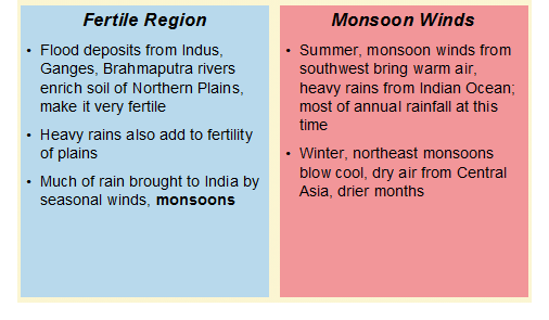
3 Notice the arrows which show the winter and summer monsoons. The summer monsoons bring moisture to the otherwise dry areas. Without the monsoons the people would starve.


4 Indus River flows across northwest edge of Indian subcontinent large landmass, part of a continent Home of one of ancient world s great river valley civilizations Indian subcontinent includes three major geographic zones Far north: Himalaya, Hindu Kush mountain systems, separating India from rest of Asia South: Deccan Plateau, high plateau receiving less rain than other parts of subcontinent Between mountains, plateau are Northern Plains, where society first developed in India
5

6
7

8
9


10


11
12 Ancient India Mr. Moore's 6 th Grade Social Studies

13 Key Terms Subcontinent-a large landmass that juts out from a continent; India was considered a subcontinent. Migrate-is to relocate or to move from one place to settle in another area. Monsoon-a strong wind that blows across a region at a certain time of the year. October- May winter monsoons blow from northeast spreading dry air Middle of June wind blows from Indian ocean summer monsoons brought rain if none=famine; if too much=deadly floods
14 Key Terms Caste- a type of social class Had to stay in caste of parents Each caste had special work and duties Citadel-a fortress in the center of a city A citadel is a group of public buildings enclosed by high brick wall
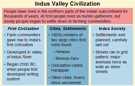
15 Key Places Himalaya Mountains- mountain system of south central Asia extending along the border between India and Tibet through Pakistan, Nepal and Bhutan Highest mountain range in the world. Was the wall that cut off India from the rest of the ancient world Indus River Valley-a valley of early civilizations along the Indus River, one of the longest rivers in the world From rich soil, farmers got to harvest a surplus of wheat and other grains Because of the surplus, the population grew and produced cities such as Mohenjo-Daro
16 Key Places Mohenjo-Daro- a large ancient city on the banks of the Indus River in the northwest of India Ganges River- a river in northern India flowing from the Himalaya Mountains to the Bay of Bengal
17 India s Geographic Setting India is a subcontinent or a large landmass that juts out from a continent Shaped like a kite, it pushes out of Asia into the Indian Ocean. India s history and culture have been influenced by the fact that it has been isolated by bodies of water (Bay of Bengal, Indian Ocean and the Arabian Sea) as well as the Himalaya Mts. India s climate is controlled by monsoons. Winter monsoons (October to May) spread dry air, while the summer monsoon picks up moisture from the ocean. People depend on the summer monsoon to provide life giving rain.
18 Life in the Indus River Valley Thanks to the fertile soil of the Indus River, valley farmers got a surplus of wheat and other grains. With that surplus, the population grew. Well-planned cities flourished in the valley. Mohenjo-Daro lay along the banks of the Indus River.


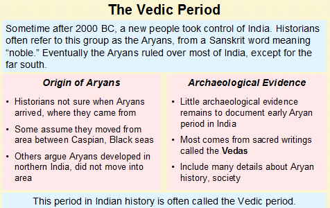
19 Conquest by the Aryans The Aryans easily conquered the people of the Indus River Valley and many of them become slaves for the Aryans. The Aryans gradually moved into the Ganges River Valley Using tools and axes that they made out of iron, they cleared areas of the thick rainforest and built, farms, villages and cities. ARYAN LIFE Were herders and warriors Had no written language but priests called Brahmins, performed religious services composed of hymns and prayers Organized their society around three classes priests, warriors & ordinary people Gradually added a fourth class to include the people they conquered (servants, laborers, farm workers)
20
3. The Buddha followed some Hindu ideas and changed others, but he did not consider himself to be a god.
 True / False Indicate whether the statement is true or false. 1. Like the ancient Greeks, Indian astronomers proposed the theory that the Earth was round and revolved around the sun. 2. During his time
1. Incredible India. Shade the map on the next page, to show India s relief. The correct shading is shown on the final page! Incredible India India
 1. Incredible India Shade the map on the next page, to show India s relief. The correct shading is shown on the final page! Incredible India India The DCSF supported Action plan for Geography is delivered
Ancient India Lesson 2
 Name: Date: Ancient India Lesson 2 Early Indian Civilization Over 1,000 miles separate the Indus River valley from Iraq, the region once known as Mesopotamia. This distance did not keep people from traveling
WORLD REGIONAL GEOGRAPHY. By Brett Lucas
 WORLD REGIONAL GEOGRAPHY By Brett Lucas SOUTH ASIA Part 1 Defining the Realm The Geographic Panorama Subcontinent: Divides oceans Divided by mountains, deserts, and fertile valleys Cultural diversity:
IX Geography CHEPTER-4 CLIMATE
 IX Geography CHEPTER-4 CLIMATE Introduction: Climate refers to the sum total of weather conditions and variations over a large area for a long period of time (more than thirty years). Weather refers to
Chapter 18 Introduction to. A f r i c a
 Chapter 18 Introduction to A f r i c a Ch. 18:1 Landforms & Resources 1. Africa s shape & landforms are the result of its location in the southern part of the ancient supercontinent of. Pangaea Over thousands
UNIT I INTRODUCTION. This unit deals with Location space relations and India s place in the world
 UNIT I INTRODUCTION This unit deals with Location space relations and India s place in the world CHAPTER INDIA LOCATION You have already seen the map of India in the previous classes. Now you closely examine
LEARNING THE LANDFORMS Grade Level: Third Presented by: Elizabeth Turcott, Endeavor Charter Academy, Springfield, Michigan Length of Unit: 14 lessons
 LEARNING THE LANDFORMS Grade Level: Third Presented by: Elizabeth Turcott, Endeavor Charter Academy, Springfield, Michigan Length of Unit: 14 lessons I. ABSTRACT This unit develops an understanding of
The Neolithic Revolution
 The Neolithic Revolution The archaeologist took out his small brush and carefully removed the remaining dirt from the fragment of human skull. To help him reconstruct the life of the ancient human, he
NATURAL REGIONS OF KENTUCKY
 NATURAL WONDERS As you travel around Kentucky taking pictures, you are excited by what you see. Kentucky offers diverse and amazing sights. The Six Regions In the West, you see the Mississippi River, the
AFRICAN KINGDOMS. Ghana. Around AD 800 the rulers of many farming villages united to create the kingdom of Ghana.
 AFRICAN KINGDOMS In Africa, towns soon became part of an important trade network. Gold and salt were the most important products traded. People needed salt in their diets to prevent dehydration. There
New India geography explained fact sheet
 New India geography explained fact sheet Where in the world is India? What is India s landscape and climate like? India is a vast peninsular in Southern Asia extending into the Indian Ocean and lying between
Name Period. The Indus Valley Civilization
 Name Period The Indus Valley Civilization Indus Valley Civilization Daily Life 3000BCE 1500BCE We know very little about the Indus Valley civilization, but what we do know is fascinating! Over 4,000 years
6 th Grade Vocabulary-ALL CAMPUSES
 6 th Grade Vocabulary-ALL CAMPUSES 6.1 History. The student understands that historical events influence contemporary events. (B) analyze the historical background of the United States to evaluate relationships
Climate, Vegetation, and Landforms
 Climate, Vegetation, and Landforms Definitions Climate is the average weather of a place over many years Geographers discuss five broad types of climates Moderate, dry, tropical, continental, polar Vegetation:
not to be republished NCERT MAJOR LANDFORMS OF THE EARTH
 6 You must have seen some of the landform features as shown in the Figure 6.1 below. You will notice that the surface of the earth is not the same everywhere. The earth has an infinite variety of landforms.
Ancient Egypt Handouts
 Ancient Egypt Handouts Map of Egypt Lower Egypt Upper Egypt Ancient Egypt 1 Map of Egypt-Answer Sheet 30ºE 40ºE 50ºN Mediterranean Sea 40ºN Africa Alexandria Rosetta Giza Memphis Sinai Pen. Middle East
Teacher s Masters California Education and the Environment Initiative. History-Social Science Standards 6.2.6. and 6.2.8. Egypt and Kush: A Tale of
 6 Teacher s Masters California Education and the Environment Initiative History-Social Science Standards 6.2.6. and 6.2.8. Egypt and Kush: A Tale of Two Kingdoms California Education and the Environment
Geography at GISSV: An Introduction to the Curriculum
 Geography at GISSV: An Introduction to the Curriculum Classes Geography is taught for two hours per week in Grades 5-9. The only exception is in Grade 8, where class is taught for one hour per week for
GLOBAL REGENTS REVIEW PACKET NUMBER 8 - PAGE 1 of 19 THIS IS GLOBAL REGENTS REVIEW PACKET NUMBER EIGHT
 GLOBAL REGENTS REVIEW PACKET NUMBER 8 - PAGE 1 of 19 THIS IS GLOBAL REGENTS REVIEW PACKET NUMBER EIGHT THE TOPICS OF STUDY IN THIS PACKET ARE: AFRICAN TRADING KINGDOMS JAPANESE FEUDALISM INDIA S CASTE
Prentice Hall World Studies 2005, 8 Book Series Correlated to: Millard Public School District (Nebraska) Social Studies Standards (Grades 6-7)
 Social Studies Standards (Grades 6-7)") Millard Public School District (Nebraska) Social Studies Standards (Grades 6-7) Note: This is a sample correlation based on four available titles of the new 2005 series in development. Titles include:,
Millard Public School District (Nebraska) Social Studies Standards (Grades 6-7) Note: This is a sample correlation based on four available titles of the new 2005 series in development. Titles include:,
5-Minute Refresher: WEATHERING AND EROSION
 5-Minute Refresher: WEATHERING AND EROSION Weathering and Erosion Key Ideas Weathering is the wearing away of the surface of rock, soil, and minerals into smaller pieces. Example of weathering: Wind and
The Rise of Civilizations
 Page 1 of 6 The Rise of Civilizations Thousands of years ago, several societies in different parts of the world changed from hunting and gathering to farming. Some began to produce surpluses of food. Those
Week 1. Week 2. Week 3
 Week 1 1. What US city has the largest population? 2. Where is Aachen? 3. What is the capitol of Florida? 4. What is the longest mountain range in Spain? 5. What countries border Equador? Week 2 1. What
What Causes Climate? Use Target Reading Skills
 Climate and Climate Change Name Date Class Climate and Climate Change Guided Reading and Study What Causes Climate? This section describes factors that determine climate, or the average weather conditions
The Southern Colonies
 The Southern Colonies About 100 men and boys sailed to Virginia in 1607. They set up a settlement. They named their new home Jamestown. They did not plant crops. They looked for gold. Just a few of the
STANDARD 3.1 Greece & Rome. STANDARD 3.2 - Mali
 2008 Curriculum Framework Grade Three Social Studies Standards Condensed format created by SOLpass. www.solpass.org Key: red text highlights NEW (2008 revision) content; crossout indicates content cut
7 WHERE AND WHY DID THE FIRST CITIES APPEAR?
 7 WHERE AND WHY DID THE FIRST CITIES APPEAR? In this three-part video David Christian explains how the rise of agriculture led to the formation of the world s first large-scale civilizations. Fueled by
Content Area Vocabulary: Activities Packet
 SAMPLE MATERIAL Content Area Vocabulary: Activities Packet Pocomoke Middle School, Maryland Topic: Adolescent Literacy Practice: Vocabulary Instruction Pocomoke Middle School has implemented a schoolwide
Lesson 3: The formation of mountains Factsheet for teachers
 Lesson 3: The formation of mountains Factsheet for teachers Vocabulary This lesson uses the following geographical terms. These should be used and explained to pupils as the lesson is taught. Core, mantle,
Rocks and Plate Tectonics
 Name: Class: _ Date: _ Rocks and Plate Tectonics Multiple Choice Identify the choice that best completes the statement or answers the question. 1. What is a naturally occurring, solid mass of mineral or
Lesson Plan: The Silk Road
 Lesson Plan: The Silk Road Provided by the Art Institute of Chicago Department of Museum Education Suggested grade level: 7 10 Estimated time: 2 3 hours Introduction The "Silk Road" was an ancient network
Ch.1. Name: Class: Date: Matching
 Name: Class: Date: Ch.1 Matching Match each item with the correct statement below. a. technology e. democracy b. diffusion f. extended family c. exports g. interdependence d. climate 1. goods sent to markets
In this chapter, you will learn about the African kingdom of Kush. Kush was located on the Nile River, to the south of Egypt.
 Name: Date: Period: Lesson 10 - The Kingdom of Kush Section 1 - Introduction In this chapter, you will learn about the African kingdom of Kush. Kush was located on the Nile River, to the south of Egypt.
Physical Geography [9th grade]
![Physical Geography [9th grade]](/thumbs/40/21789377.jpg "Physical Geography [9th grade]") Trinity University Digital Commons @ Trinity Understanding by Design: Complete Collection Understanding by Design 6-2014 Physical Geography [9th grade] Meghan Harrington Trinity University, [email protected]
Trinity University Digital Commons @ Trinity Understanding by Design: Complete Collection Understanding by Design 6-2014 Physical Geography [9th grade] Meghan Harrington Trinity University, [email protected]
Egypt Lesson Plan 7: Touring Ancient Egypt
 Egypt Lesson Plan 7: Touring Ancient Egypt Introduction: This lesson focuses on the importance of geographic features and the abundance of natural resources that helped ancient Egypt become the world s
CHAPTER ONE: A CONTINENT OF VILLAGES, TO 1500
 CHAPTER ONE: A CONTINENT OF VILLAGES, TO 1500 SETTLING THE CONTINENT Who Are the Indian People? Migration from Asia Clovis: The First American Technology NEW WAYS OF LIVING ON THE LAND Hunting Traditions
Bountiful Beetles Lesson Plan
 Bountiful Beetles Lesson Plan Lesson Title: Bountiful Beetles Objectives: Students will identify the life cycle, anatomy and other characteristics of beetles. Students will conduct a simple research using
BALBHARATI PUBLIC SCHOOL, PITAMPURA,NEW DELHI COMPREHENSIVE NOTES CHAPTER-6 HUMAN RESOURCES CLASS-VIII SUBJECT-GEOGRAPHY FINAL TERM
 BALBHARATI PUBLIC SCHOOL, PITAMPURA,NEW DELHI COMPREHENSIVE NOTES CHAPTER-6 HUMAN RESOURCES CLASS-VIII SUBJECT-GEOGRAPHY FINAL TERM Q1. Why are people considered as a resource? A1. People are a nation
The Prediction of Indian Monsoon Rainfall: A Regression Approach. Abstract
 The Prediction of Indian Monsoon Rainfall: Goutami Bandyopadhyay A Regression Approach 1/19 Dover Place Kolkata-7 19 West Bengal India [email protected] Abstract The present paper analyses the monthly
Mesopotamia is the first known civilization. Mesopotamia means land between two rivers. This civilization began on the plains between the Tigris and
 Mesopotamia Review Mesopotamia is the first known civilization. Mesopotamia means land between two rivers. This civilization began on the plains between the Tigris and Euphrates Rivers. This curving strip
Index Insurance in India
 Index Insurance in India Kolli N Rao, PhD Aon Benfield, India Indian Agriculture & Risks What s Index Insurance? Why Index Insurance? The Outline Architecture of Indian Crop Insurance Coverage: The Numbers
GLOBAL REGENTS REVIEW PACKET NUMBER TWO - PAGE 1 of 23 THIS IS GLOBAL REGENTS REVIEW PACKET NUMBER TWO
 GLOBAL REGENTS REVIEW PACKET NUMBER TWO - PAGE 1 of 23 THIS IS GLOBAL REGENTS REVIEW PACKET NUMBER TWO THE TOPICS OF STUDY IN THIS PACKET ARE: GEOGRAPHY IMPACTS HOW PEOPLE DEVELOP - This topic is divided
WEATHERING, EROSION, AND DEPOSITION PRACTICE TEST. Which graph best shows the relative stream velocities across the stream from A to B?
 NAME DATE WEATHERING, EROSION, AND DEPOSITION PRACTICE TEST 1. The diagram below shows a meandering stream. Measurements of stream velocity were taken along straight line AB. Which graph best shows the
Wheat Farming: Then and Now
 Wheat Farming: Then and Now Written by Lisa Cocca California Education and the Environment Initiative History-Social Science Standard 2.4.1. Farming has changed in many ways. In 1900, farms needed many
INTO WHICH CASTE HAVE YOU BEEN CAST?: INDIA'S CASTE SYSTEM Ann Crocker West Mid-High School Norman, Oklahoma
 INTO WHICH CASTE HAVE YOU BEEN CAST?: INDIA'S CASTE SYSTEM Ann Crocker West Mid-High School Norman, Oklahoma ABSTRACT: This lesson teaches about the Caste System of Ancient India by grouping students so
Insurance environment in India: Bottlenecks and opportunities for a cost effective insurance products. Srinivasa Rao Gattineni
 Insurance environment in India: Bottlenecks and opportunities for a cost effective insurance products Srinivasa Rao Gattineni Rainfall variability is dominant due to the presence of the Monsoon (seasonal
The Ancient Indus Valley Civilization
 Teacher s Guide The Ancient Indus Valley Civilization A Guide to Accompany Indus River: Journey of a Lifetime A Unit of National Standards for World History Grades 5-12 Designed and Developed By Abha Sinha
Jainism Jainism also began in India; religion teaches ahimsa nonviolence - Jains believe all living things have souls and should not be hurt
 Lesson 3 Buddhism and India s Golden Age MAIN IDEAS Belief System A teacher called the Buddha developed a new religion that focused on helping people to escape suffering. Government The Maurya rulers united
11A Plate Tectonics. What is plate tectonics? Setting up. Materials
 11A Plate Tectonics What is plate tectonics? Earth s crust plus the upper mantle forms the lithosphere. Earth s lithosphere is broken in a number of different pieces. How these pieces move and interact
Climate Change Impacts in the Asia/Pacific Region
 Climate Change Impacts in the Asia/Pacific Region Global CC threat CC in the A/P region The Stern Review and IPCC 4 th Assessment Report both state that climate change will have adverse impact on people
West Africa: Bantu Migration and the Stainless Society
 West Africa: Bantu Migration and the Stainless Society Bantu Migration Around 1500 BCE farmers of the Niger and Benue River valleys in West Africa began migrating south and east, bringing with them their
Five Themes of Geography
 Five Themes of Geography Studying the geography of the entire world is a huge task. You can make that task easier by using the five themes of geography: location, regions, place, movement, and humanenvironment
Answer Keys to Unit Tests
 Reading Geography Series Answer Keys to Unit Tests Unit 1 Patterns in Human Geography Unit 2 Economic Systems Unit 3 Migration 8 Portage & Main Press Unit Test for Patterns in Human Geography A. Understanding
Igneous rocks formed when hot molten material (magma) cools and hardens (crystallizes).
 cools and hardens (crystallizes).") Objectives You will learn about how the land of North Dakota was formed. Introduction North Dakota is a wonderful place to live. Have you ever though about how it was formed? To answer that question, you
Objectives You will learn about how the land of North Dakota was formed. Introduction North Dakota is a wonderful place to live. Have you ever though about how it was formed? To answer that question, you
Physiography, Geography and Climate of Latin America (Lecture 3)
") Physiography, Geography and Climate of Latin America (Lecture 3) Natural Landmarks in Latin America World's longest and second highest mountain range, and the world's highest active volcanoes. Biggest
Physiography, Geography and Climate of Latin America (Lecture 3) Natural Landmarks in Latin America World's longest and second highest mountain range, and the world's highest active volcanoes. Biggest
Deserts, Wind Erosion and Deposition
 Deserts, Wind Erosion and Deposition By definition, a desert has less than 10 in (25 cm) of precipitation per year. Deserts occur at 30 o and 60 o in regions of descending air. Deserts can be hot or cold.
Structure of Culture Each of the three subsystems are linked. Ex. #1: Dwellings As artifacts: They re objects that were made by and used by a society.
 The Study of Human Geography Chapter 3, Section 1 Environmental Determinism vs. Possibilism Environmental Determinism Belief that the physical environment, esp. climate, exclusively shapes humans, their
African-American History
 African-American History Reader and Workbook Richard Beck Royal Fireworks Press Unionville, New York Table of Contents Introduction...1 General Reading List...4 Vocabulary Words...6 Famous African-Americans...8
Regional Atlas: Introduction to South Asia
 Name Regional Atlas: Introduction to South Asia Study the map on page 593 of the textbook. 1. The Khyber Pass connects which two countries? CHAPTER 28 2. What capital city is located at 80 E longitude?
Monsoon Variability and Extreme Weather Events
 Monsoon Variability and Extreme Weather Events M Rajeevan National Climate Centre India Meteorological Department Pune 411 005 [email protected] Outline of the presentation Monsoon rainfall Variability
WEATHER, CLIMATE AND ADAPTATIONS OF ANIMALS TO CLIMATE
 7 WEATHER, CLIMATE AND ADAPTATIONS OF ANIMALS TO CLIMATE TEXTBOOK QUESTIONS AND ANSWERS Q.1. Why weather changes so frequently? Ans. All changes in the weather are caused by the sun. The movement of the
SOCIAL STUDIES UNIT OUTLINES FOURTH GRADE
 SOCIAL STUDIES UNIT OUTLINES FOURTH GRADE In fourth grade, students use their understanding of social studies concepts and skills to explore Washington State in the past and present. Students learn about
www.amnh.org Continental Drift is the movement of the Earth s continents in relation to one another.
 A Plate Tectonic Puzzle Introduction The Earth s crust is not a solid shell. It is made up of thick, interconnecting pieces called tectonic plates that fit together like a puzzle. They move atop the underlying
Adjectives Using Ocean Facts
 GRACE Educational Curriculum OCEANS http://www.tsgc.utexas.edu/ Teachers Grades 3-5 Language Arts Adjectives Using Ocean Facts Background Information: Teaching students to use adjectives more effectively
Rural Settlement Patterns
 Rural Settlement Patterns A summary with pictures. Courtesy of Crescent School There are three types of rural settlement patterns that occurred where large numbers of people settled: the long lots of
The Polar Climate Zones
 The Polar Climate Zones How cold is it in the polar climate? Polar areas are the coldest of all the major climate zones The Sun is hardly ever high enough in the sky to cause the plentiful ice to melt,
WHI.03: Early River Valley Civilizations
 WHI.03: Early River Valley Civilizations In this space, you will create a visual representation of what you have learned in the notes that follow on pages 18-32. You will be graded on your use of space,
The Interconnectedness of Ancient Peoples Map Study Janet Cuenca Parkway Northeast Middle School St. Louis County, Missouri
 The Interconnectedness of Ancient Peoples Map Study Janet Cuenca Parkway Northeast Middle School St. Louis County, Missouri Level: Grade 7 Length of Unit: Intermittent days throughout the school year,
Ancient China. Vocabulary. 15. Terracotta Army collection of seven thousand life-sized sculptures made from pottery in the tomb of Shi Huangdi
 Ancient China 1. Analects the collected sayings and teachings of Confucius 2. Bronze Age (3300 1200 B.C.) time when people made weapons and tools from bronze 3. calligraphy artistic form of ancient Chinese
The Regions of the United States
 CHAPTER 1 Identify characteristic landforms of the five major regions of the United States. Describe, compare, and contrast regional climates of the United States. Identify regional resources of the United
Geography affects climate.
 KEY CONCEPT Climate is a long-term weather pattern. BEFORE, you learned The Sun s energy heats Earth s surface unevenly The atmosphere s temperature changes with altitude Oceans affect wind flow NOW, you
Climates are described by the same conditions used to describe
 58 The Causes of Climate R E A D I N G Climates are described by the same conditions used to describe weather, such as temperature, precipitation, and wind. You now know that oceans have an important effect
ORIGIN OF THE ARYANS. Argument Against Aryan Migration to the Indian Suncontinent BY K.J. SHARMA
 ORIGIN OF THE ARYANS Argument Against Aryan Migration to the Indian Suncontinent BY K.J. SHARMA Aryan in English is derived from the Sanskrit language, "Ārya" Ārya" " meaning noble, civilized or "honorable.
Agricultural Production and Research in Heilongjiang Province, China. Jiang Enchen. Professor, Department of Agricultural Engineering, Northeast
 1 Agricultural Production and Research in Heilongjiang Province, China Jiang Enchen Professor, Department of Agricultural Engineering, Northeast Agricultural University, Harbin, China. Post code: 150030
2015.16 Seventh Grade, Social Studies, Quarter 1
 2015.16 Seventh Grade, Social Studies, Quarter 1 The Fall and Legacy of Rome and the Early Modern World Civilizations of Africa, China, and the Islamic World: Students analyze the legacy of the Roman Empire
The concepts developed in this standard include the following: Oceans cover about 70% of the surface of the Earth.
 Name Date Grade 5 SOL 5.6 Review Oceans Made by SOLpass - www.solpass.org [email protected] Reproduction is permitted for SOLpass subscribers only. The concepts developed in this standard include
8.5 Comparing Canadian Climates (Lab)
") These 3 climate graphs and tables of data show average temperatures and precipitation for each month in Victoria, Winnipeg and Whitehorse: Figure 1.1 Month J F M A M J J A S O N D Year Precipitation 139
These 3 climate graphs and tables of data show average temperatures and precipitation for each month in Victoria, Winnipeg and Whitehorse: Figure 1.1 Month J F M A M J J A S O N D Year Precipitation 139
Ride the Rock Cycle. Suggested Goals: Students will gain an understanding of how a rock can move through the different stages of the rock cycle.
 Illinois State Museum Geology Online http://geologyonline.museum.state.il.us Ride the Rock Cycle Grade Level: 5 6 Purpose: To teach students that the rock cycle, like the water cycle, has various stages
Period #1: Technological and Environmental Transformations, c. 8,000 B.C.E. - 600 B.C.E. Study Guide by Key Concepts
 Note: the question numbers are my own customization, and do NOT reflect official College Board designation. Ask yourself the question in the left column. Your answer should come close to the middle column.
Key Idea 2: Ecosystems
 Key Idea 2: Ecosystems Ecosystems An ecosystem is a living community of plants and animals sharing an environment with non-living elements such as climate and soil. An example of a small scale ecosystem
Year 2 History: Ancient Egypt Resource Pack
 Year 2 History: Ancient Egypt Resource Pack This pack includes the following lessons: Locating Egypt The River Nile Archeology Hieroglyphics Pharaohs Every effort has been made to seek permission for the
Plate tectonics states that the Earth's crust and upper mantle are broken into sections, called plates.
 Notes on Plate Tectonics Plate tectonics states that the Earth's crust and upper mantle are broken into sections, called plates. These plates move around the mantle. Plates are composed of the crust and
Note Taking Study Guide CIVILIZATIONS OF MESOAMERICA
 SECTION 1 Note Taking Study Guide CIVILIZATIONS OF MESOAMERICA Focus Question: What factors encouraged the rise of powerful civilizations in Mesoamerica? A. As you read People Settle in the Americas, complete
Prentice Hall World Studies: Latin America 2008 Correlated to: Missouri Social Studies Grade Level Expectations (Grade 7)
") Principles of Constitutional Democracy 1. Knowledge of the principles expressed in documents shaping constitutional democracy in the United States A. (1) Principles expressed in documents shaping constitutional
Principles of Constitutional Democracy 1. Knowledge of the principles expressed in documents shaping constitutional democracy in the United States A. (1) Principles expressed in documents shaping constitutional
Geologic Time Scale Notes
 Name: Date: Period: 1 2 3 4 5 6 7 Notes Essential Question: What is the geologic time scale? Vocabulary: Geology: the scientific study of the origin, history, and structure of Earth and the processes that
VISUAL 6.1 GREAT BRITAIN S AMERICAN COLONIES
 SPECIALIZATION AND TRADE IN THE THIRTEEN COLONIES LESSON 6 VISUAL 6.1 GREAT BRITAIN S AMERICAN COLONIES GREAT BRITAIN S COLONIES All colonies are rich in natural resources but short on labor. PRODUCTIVE
6. Base your answer to the following question on the graph below, which shows the average monthly temperature of two cities A and B.
 1. Which single factor generally has the greatest effect on the climate of an area on the Earth's surface? 1) the distance from the Equator 2) the extent of vegetative cover 3) the degrees of longitude
Unit 2 Lesson 4 The Geologic Time Scale. Copyright Houghton Mifflin Harcourt Publishing Company
 Once Upon a Time How have geologists described the rate of geologic change? Geology is the scientific study of the origin, history, and structure of Earth and the processes that shape it. Early geologists
GLOBAL REGENTS REVIEW PACKET NUMBER THREE - PAGE 1 of 19 THIS IS GLOBAL REGENTS REVIEW PACKET NUMBER THREE CHARACTERISTICS (ELEMENTS) OF CIVILIZATIONS
 OF CIVILIZATIONS") GLOBAL REGENTS REVIEW PACKET NUMBER THREE - PAGE 1 of 19 THIS IS GLOBAL REGENTS REVIEW PACKET NUMBER THREE THE TOPICS OF STUDY IN THIS PACKET ARE: THE NEOLITHIC REVOLUTION CHARACTERISTICS (ELEMENTS) OF
GLOBAL REGENTS REVIEW PACKET NUMBER THREE - PAGE 1 of 19 THIS IS GLOBAL REGENTS REVIEW PACKET NUMBER THREE THE TOPICS OF STUDY IN THIS PACKET ARE: THE NEOLITHIC REVOLUTION CHARACTERISTICS (ELEMENTS) OF
WORLD HISTORY AND GEOGRAPHY: ANCIENT CIVILIZATIONS
 WORLD HISTORY AND GEOGRAPHY: ANCIENT CIVILIZATIONS Students in grade six expand their understanding of history by studying the people and events that ushered in the dawn of the major Western and non- Western
AP Human Geography 2006 Scoring Guidelines
 AP Human Geography 2006 Scoring Guidelines The College Board: Connecting Students to College Success The College Board is a not-for-profit membership association whose mission is to connect students to
CHINA OVERVIEW: A BRIEF HISTORY OF CHINESE DYNASTIES. Student Handouts, Inc.
 CHINA OVERVIEW: A BRIEF HISTORY OF CHINESE DYNASTIES Student Handouts, Inc. GEOGRAPHY OF CHINA Larger than the United States Climate varies North Temperate and cold South Subtropical Erosion Floods and
ES Chapter 10 Review. Name: Class: Date: Multiple Choice Identify the choice that best completes the statement or answers the question.
 Name: Class: Date: ES Chapter 10 Review Multiple Choice Identify the choice that best completes the statement or answers the question. 1. Scientists used the pattern of alternating normal and reversed
Teacher s Guide For. Glaciers and Ice Caps The Melting
 Teacher s Guide For Glaciers and Ice Caps The Melting For grade 7 - College Program produced by Centre Communications, Inc. for Ambrose Video Publishing, Inc. Executive Producer William V. Ambrose Teacher's
A Speech by the President of Iceland Ólafur Ragnar Grímsson at the Himalaya-Third Pole Circle
 A Speech by the President of Iceland Ólafur Ragnar Grímsson at the Himalaya-Third Pole Circle Thimphu, Bhutan 5 February 2015 Your Royal Highnesses Honorable Prime Minister Your Excellencies Distinguished
DAMN WEATHER! 4. Bangladesh is one of the most populated countries. 1 Lead-in. 3 Follow-up. 2 Main activity
 DAMN WEATHER! Time Level Skills Knowledge goal Materials 45 60 minutes pre-intermediate reading, speaking to introduce the impact of climate change on developing countries through the example of Bangladesh