Geography of SC. One of the four elements of History Pages 1-4
|
|
|
- Zoe Shields
- 7 years ago
- Views:
Transcription
1 Geography of SC One of the four elements of History Pages 1-4
2 The Theory of Continental Drift 3 billion years ago the land thqt became North America first appeared ot of the sea Movement of tectonic plates below the earth s surface then became part of one huge continent known as Pangaea. When North America collided with the coast of West Africa about a billion years ago the Appalachian Mountains arose. **Pangaea: An ancient huge continent
3 Did You Know? Ancient oceans covered parts of SC all the way up to the midlands? Shells and fossils of sea animals have been found in the Midlands (Columbia Area). The Coastal Plain is rich in phosphates as a result of the land being covered by the ocean. The Appalachian Mountains are smoother and more rounded because they are older than the mountains in the western part of North America?
 The word piedmont means foothill or foot of the mountain.")
4 Did You Know? Two of our inland lakes, Marion and Moultrie, are among the world s largest man made lakes. In SC, we have many monadnocks. (don t know what they are?...first one to me with the correct answer wins a free homework pass) The word piedmont means foothill or foot of the mountain.(remember this, you will hear it again)
 Brevard Zone: When North America collided with West Africa, the Piedmont joined North America at the point where the")
5 SC Geography (cont.) Brevard Zone: When North America collided with West Africa, the Piedmont joined North America at the point where the Appalachian Mountanins began to rise. The two land masses joined at a fault line known as the Brevard Zone.
6 Assignment Using the handout and the map on page 4 of your text book, label the 6 major regions of South Carolina. Be sure you create a key which denotes the colors of each area. Label each area as well. ree_five/units/regions/regions.htm Upon completion, place the map in your SC Portfolio. You will need this map for our culminating project.

7 Geography Part II Pages 4-10 The first dinosaur fossils in SC were found in Williamsburg County in They were two teeth of the hadrosaur, a planteating duck billed dinosaur that lived all over the United States. In 1992 and 1994 fossils of the theropod, a meat-eating dinosaur, were found in Florence County.
8 Assignment On your county map, label any items of interest that we discuss in class. For example, put the names of the two dinosaur fossils we have just discussed. Put in the 6 regions. Label the Fall Zone Place the map in your notebooks so that as we continue, you may add to your maps.
9 Present Day SC Location: Southern Atlantic coast. Occupies 31,055 square miles. Ranks 40 th in size among the fifty states. Geographically split into two broad areas by the fall zone. This is an area that divides the state into the Up and Low Country. It stretches across South Carolina through the Sandhills from the Savannah River, near Aiken, through Columbia to Cheraw at the North Carolina border. **** Use your county map to denote the fall zone. Check with your neighbor to see if you are in agreement.
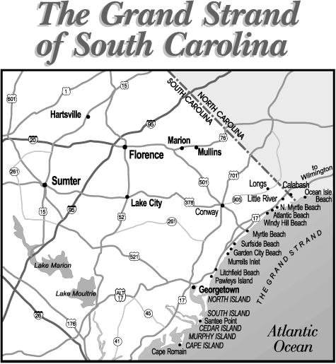
10 Present Day (cont.) Coastal Zone Six Regions of SC Stretches along the Atlantic coast. About 185 miles long and reaches ten miles into the interior. Divided into three sections: a. Grand Strand: broad, sandy beaches, begins at the NC border and ends sixty miles to the southwest at Winyah Bay.
11
12 Regions of SC (cont.) b. Santee Delta: South of Winyah Bay to Bull s Bay, the largest delta on the east coast, built up by sediment brought down the coastal rivers from the interior.

13 Santee Delta
14 Coastal Zone (cont.) c. Barrier Islands: from Bull s Bay to the Savannah River, low sandy islands which protect the coast from the stormy Atlantic. Once the site of rich plantations that grew seaisland, or long-staple, cotton. On the mainland, salt marshes and streams yield an abundance of seafood.
15 Coastal Zone (cont.) d. Coastal Plain: the largest landform region in the state and can be divided into the Outer and Inner Coastal Plain. 1. Outer Coastal Plain (Lower Pine Belt) miles wide. Rivers in this region rise and fall with the tide. There are dark inland swamps and savannas (areas of flat land without trees.) Great rice and indigo plantations once flourished. 2. Inner Coastal Plain (Upper Pine Belt feet above sea level. Rich bottom lands where cotton plantations developed after the American Revolution. The Congaree River southeast of Columbia is one of the largest tracts of original forests in the country. Some of the tallest trees east of the Mississippe River grow there. Congaree National Park (22,000 acres) is the only national park in SC. (Virtual tour using Atlas CD) **Carolina Bays: Oval depressions in the soil, they look like swamps surrounded by trees. The smallest bays are four to five acres in size. BIG Swamp in Manchester State Forest is the largest with several thousand acres.
16
17 Geography of SC pages 8-9 The Sandhill Region: Extends along the fall zone. Has red hills to the south and sandhills to the north. George Washington rode through the Sandhills between Columbia and Camden and said the are was the most miserable pine barren he had ever seen. In 1940 s poor farmers lived there. Many had dietary diseases and ate clay or sand. They were known as clay eaters or sandlappers. Today pine forests and fruit orchards grow in the area.
18 SC Geography Pages 8-9 The Piedmont: Takes up nearly one third of the state. Covered with forests or fields of Up Country cotton plantations. Creeks and rivers of the region provided waterpower for the textile industry that grew up in the state after the Civil War.
19 Geography SC History pages 8-9 The Blue Ridge: (sometimes called Alpine Region) Approximately 500 square miles of Blue Ridge Mountains and valleys. Highest peak in SC is Sassafras Mountain in Pickens County. Whitewater Falls, in Oconee County, is the highest waterfall east of the Mississipp River.
20 SC Geography The River Systems Savannah River system: drains into the Savannah river on the Georgia border. Santee River System: Located in the center of the state. Is the largest in the state. Pee Dee River System: Located in the northeast. ***These rivers form in the mountains and flow southeast across the state. Upcountry they fall quickly from the hills into the valleys. At the fall zone they become broad and sluggish. They carry rich soil and deposit it along the river banks
21 Rivers (cont.) Black Water Rivers: carry very little sediment, and the color comes from a high tannic-acid content. a. Black River b. Combahee c. Edisto River

22 Assignment: Label your map: Rivers of SC. Make sure that you label the following rivers: Santee, Black, Combahee, Congaree, Great PeeDee, Waccamaw, and the Savannah Rivers. On the side of your map list the three Major Rivers of SC.
23 Climate of SC Temperate Climate: Experience four seasons. (humid and subtropical) Rais is most abundant in February and July and August. Hurricanes sweep coastal ares in the late summer and early fall. June through September is considered the Hurricane Season Great Sea Island Storm struck Savannah, Beaufort and the barrier island (Charleston) and killed 2,000. Hurricane Hugo in 1989 killed 17 people and left 65,000 people homeless. Over $5 billioin in property damages.

24
Mountains lie in part of which three South Carolina counties? South Carolina s mountains are known by what collective name?
 WEEK SIX Mountains lie in part of which three South Carolina counties? South Carolina s mountains are known by what collective name? The Blue Ridge Mountains are part of which chain of mountains that extends
Climate, Vegetation, and Landforms
 Climate, Vegetation, and Landforms Definitions Climate is the average weather of a place over many years Geographers discuss five broad types of climates Moderate, dry, tropical, continental, polar Vegetation:
Chapter 18 Introduction to. A f r i c a
 Chapter 18 Introduction to A f r i c a Ch. 18:1 Landforms & Resources 1. Africa s shape & landforms are the result of its location in the southern part of the ancient supercontinent of. Pangaea Over thousands
LEARNING THE LANDFORMS Grade Level: Third Presented by: Elizabeth Turcott, Endeavor Charter Academy, Springfield, Michigan Length of Unit: 14 lessons
 LEARNING THE LANDFORMS Grade Level: Third Presented by: Elizabeth Turcott, Endeavor Charter Academy, Springfield, Michigan Length of Unit: 14 lessons I. ABSTRACT This unit develops an understanding of
NATURAL REGIONS OF KENTUCKY
 NATURAL WONDERS As you travel around Kentucky taking pictures, you are excited by what you see. Kentucky offers diverse and amazing sights. The Six Regions In the West, you see the Mississippi River, the
ES Chapter 10 Review. Name: Class: Date: Multiple Choice Identify the choice that best completes the statement or answers the question.
 Name: Class: Date: ES Chapter 10 Review Multiple Choice Identify the choice that best completes the statement or answers the question. 1. Scientists used the pattern of alternating normal and reversed
 Benchmark Identify physical & human characteristics of places, regions in North America. Grade Level Indicator Describe, compare landforms, climates, population, vegetation, economic characteristics of
Alfred Wegener s Theory of Continental Drift Became Modern Plate Tectonics. Wegener in Greenland about 1912. He froze to death there in 1930.
 Alfred Wegener s Theory of Continental Drift Became Modern Plate Tectonics Wegener in Greenland about 1912. He froze to death there in 1930. Science is self correcting. The Scientific Method The history
Plate Tectonics Short Study Guide
 Name: Class: Date: Plate Tectonics Short Study Guide Multiple Choice Identify the letter of the choice that best completes the statement or answers the question. 1. The existence of coal beds in Antarctica
Fifteen 45 minute class periods. Length of Unit: STAGE 1: DESIRED RESULTS. Geography of Virginia. Name: Wilma W. Tyler 4 th Grade Virginia Studies
 Geography of Virginia Name: Wilma W. Tyler 4 th Grade Virginia Studies Major Topic for the Unit of Instruction: Relative Location of Virginia, Regions, and Water Features Length of Unit: Fifteen 45 minute
Southern AER Atmospheric Education Resource
 Southern AER Atmospheric Education Resource Vol. 9 No. 5 Spring 2003 Editor: Lauren Bell In this issue: g Climate Creations exploring mother nature s remote control for weather and Climate. g Crazy Climate
Region of Georgia : Mountains
 Region of Georgia : Mountains Northern most region of GA Cold weather in the winter Brasstown Bald is the highest point in Georgia Lots of creeks and streams High above sea level Poor soil for farming
Answer Keys to Unit Tests
 Reading Geography Series Answer Keys to Unit Tests Unit 1 The Five Themes of Geography Unit 2 Patterns in Physical Geography Unit 3 Natural Resources 7 Portage & Main Press Unit Test for The Five Themes
6.E.2.2 Plate Tectonics, Earthquakes and Volcanoes
 Name: Date: 1. The road shown below was suddenly broken by a natural event. 3. The convergence of two continental plates would produce Which natural event most likely caused the crack in the road? island
Impacts of Global Warming on North Carolina s Coastal Economy
 Impacts of Global Warming on North Carolina s Coastal Economy IMPACTS OF GLOBAL WARMING ON NORTH CAROLINA S COASTAL ECONOMY Key Findings Global warming is projected to have significant impacts on North
Allows teachers to print reports for individual students or an entire class.
 Map and Globe Skills Developed by teachers and geography specialists, Map and Globe Skills provides the strategies, skills and practice your students need to develop a strong understanding of basic mapping
BASIC LESSON Objective(s)
") [Geology - Landforms] [K-1: Basic] [Grades 2-3: Advanced] BACKGROUND Landforms are natural features of the Earth's surface. They are created by the movement of ice or water, earthquakes, lava flows, volcanoes,
[Geology - Landforms] [K-1: Basic] [Grades 2-3: Advanced] BACKGROUND Landforms are natural features of the Earth's surface. They are created by the movement of ice or water, earthquakes, lava flows, volcanoes,
Chapter 8: Plate Tectonics -- Multi-format Test
 Name: Class: Date: ID: A Chapter 8: Plate Tectonics -- Multi-format Test Modified True/False Indicate whether the statement is true or false. If false, change the identified word or phrase to make the
1. You are about to begin a unit on geology. Can anyone tell me what geology is? The study of the physical earth I.
 PLATE TECTONICS ACTIVITY The purpose of this lab is to introduce the concept of plate tectonics and the formation of mountains. Students will discuss the properties of the earth s crust and plate tectonics.
Plate Tectonics. Hi, I am Zed and I am going to take you on a trip learning about Plate Tectonics. And I am Buddy Zed s mascot
 Plate Tectonics Hi, I am Zed and I am going to take you on a trip learning about Plate Tectonics And I am Buddy Zed s mascot Continental Drift Alfred Wegener proposed that continents were not always where
Layers of the Earth and Plate Tectonics
 Layers of the Earth and Plate Tectonics Objectives: explain various ways the earth can be changed by natural forces define the term Geology define the terms Crust, Mantle, Outer Core and Inner Core classify
Tectonic plates have different boundaries.
 KEY CONCEPT Plates move apart. BEFORE, you learned The continents join and break apart The sea floor provides evidence that tectonic plates move The theory of plate tectonics helps explain how the plates
Deserts, Wind Erosion and Deposition
 Deserts, Wind Erosion and Deposition By definition, a desert has less than 10 in (25 cm) of precipitation per year. Deserts occur at 30 o and 60 o in regions of descending air. Deserts can be hot or cold.
Interactive Plate Tectonics
 Interactive Plate Tectonics Directions: Go to the following website and complete the questions below. http://www.learner.org/interactives/dynamicearth/index.html How do scientists learn about the interior
Rocks and Plate Tectonics
 Name: Class: _ Date: _ Rocks and Plate Tectonics Multiple Choice Identify the choice that best completes the statement or answers the question. 1. What is a naturally occurring, solid mass of mineral or
Tectonic plates push together at convergent boundaries.
 KEY CONCEPT Plates converge or scrape past each other. BEFORE, you learned Plates move apart at divergent boundaries In the oceans, divergent boundaries mark where the sea floor spreads apart On land,
Unit 4 Lesson 2 Plate Tectonics. Copyright Houghton Mifflin Harcourt Publishing Company
 Puzzling Evidence What evidence suggests that continents move? In the late 1800s, Alfred Wegener proposed his hypothesis of continental drift. According to this hypothesis, the continents once formed a
How Did These Ocean Features and Continental Margins Form?
 298 10.14 INVESTIGATION How Did These Ocean Features and Continental Margins Form? The terrain below contains various features on the seafloor, as well as parts of three continents. Some general observations
www.amnh.org Continental Drift is the movement of the Earth s continents in relation to one another.
 A Plate Tectonic Puzzle Introduction The Earth s crust is not a solid shell. It is made up of thick, interconnecting pieces called tectonic plates that fit together like a puzzle. They move atop the underlying
SECOND GRADE PLATE TECTONICS 1 WEEK LESSON PLANS AND ACTIVITIES
 SECOND GRADE PLATE TECTONICS 1 WEEK LESSON PLANS AND ACTIVITIES PLATE TECTONIC CYCLE OVERVIEW OF SECOND GRADE VOLCANOES WEEK 1. PRE: Investigating the parts of a volcano. LAB: Comparing the parts of a
Continents join together and split apart.
 KEY CONCEPT Continents change position over time. BEFORE, you learned Earth s main layers are the core, the mantle, and the crust The lithosphere and asthenosphere are the topmost layers of Earth The lithosphere
Exploring South Carolina
 Exploring South Carolina Rose Capell Lander University Rosemary_81@hotmail.com Overview This lesson is based on South Carolina: An Atlas. Students will use the atlas to compare the regions in which the
Geography Is... More than a dot on the map.
 Geography Is... More than a dot on the map. Google Maps Absolute Loca-on North Carolina is located at La7tude 35.80 degrees North and Longitude 79.0 degrees West. The capital city, Raleigh is located at
Week 1. Week 2. Week 3
 Week 1 1. What US city has the largest population? 2. Where is Aachen? 3. What is the capitol of Florida? 4. What is the longest mountain range in Spain? 5. What countries border Equador? Week 2 1. What
Plate Tectonics Web-Quest
 Plate Tectonics Web-Quest Part I: Earth s Structure. Use the following link to find these answers: http://www.learner.org/interactives/dynamicearth/structure.html 1. Label the layers of Earth in the diagram
Igneous rocks formed when hot molten material (magma) cools and hardens (crystallizes).
 cools and hardens (crystallizes).") Objectives You will learn about how the land of North Dakota was formed. Introduction North Dakota is a wonderful place to live. Have you ever though about how it was formed? To answer that question, you
Objectives You will learn about how the land of North Dakota was formed. Introduction North Dakota is a wonderful place to live. Have you ever though about how it was formed? To answer that question, you
Educator s Guide to Learning about Mexico Using Google Earth
 Educator s Guide to Learning about Mexico Using Google Earth Overview: Students will research the physical features of Mexico using Google Earth to learn about Mexico s oceans, gulfs, bays, lagoons, rivers,
The Regions of the United States
 CHAPTER 1 Identify characteristic landforms of the five major regions of the United States. Describe, compare, and contrast regional climates of the United States. Identify regional resources of the United
Geomorphology is the Study of Landforms. Usually by Erosion, Transportation and Deposition
 Geomorphology is the Study of Landforms and the Processes that t Create Them, Usually by Erosion, Transportation and Deposition Fluvial = running water, rivers and floodplains Glacial = flowing ice in
Unit 2 Lesson 4 The Geologic Time Scale. Copyright Houghton Mifflin Harcourt Publishing Company
 Once Upon a Time How have geologists described the rate of geologic change? Geology is the scientific study of the origin, history, and structure of Earth and the processes that shape it. Early geologists
Geologic Time Scale Notes
 Name: Date: Period: 1 2 3 4 5 6 7 Notes Essential Question: What is the geologic time scale? Vocabulary: Geology: the scientific study of the origin, history, and structure of Earth and the processes that
Geography at GISSV: An Introduction to the Curriculum
 Geography at GISSV: An Introduction to the Curriculum Classes Geography is taught for two hours per week in Grades 5-9. The only exception is in Grade 8, where class is taught for one hour per week for
LANDFORMS OF THE EARTH STD VIII
 LANDFORMS OF THE EARTH STD VIII 1) What do you understand by the term geomorphology? A) Geomorphology is the systematic study of the Earth s relief features. Geo means earth; morph meaning form and ology
NATURAL RESOURCES & NATURAL FEATURES
 A3 NATURAL RESOURCES & NATURAL FEATURES INTRODUCTION This chapter will discuss the topography, geology, soils, and other natural features found in Casco Township. The identification of the natural features
Mini Dinosaurs. Grades K 1 2. Compiled by
 Mini Dinosaurs Grades K 1 2 Compiled by Leanne M. Burrow, Extension educator, 4 H/ Youth development, Purdue University Cooperative Extension Service Henry County Resources and References Exploring 4 H,
SOUTH CAROLINA STATE COMPREHENSIVE OUTDOOR RECREATION PLAN (SCORP)
") SOUTH CAROLINA STATE COMPREHENSIVE OUTDOOR RECREATION PLAN (SCORP) 2013 Nikki R. Haley Governor of South Carolina Duane Parrish Director, South Carolina Department of Parks, Recreation and Tourism Phil
SOUTH CAROLINA STATE COMPREHENSIVE OUTDOOR RECREATION PLAN (SCORP) 2013 Nikki R. Haley Governor of South Carolina Duane Parrish Director, South Carolina Department of Parks, Recreation and Tourism Phil
Georgia Performance Standards Framework for Science Grade 6. Unit Organizer: Geology: Inside the Earth (Approximate Time: 7 Weeks)
") The following instructional plan is part of a GaDOE collection of Unit Frameworks, Performance Tasks, examples of Student Work, and Teacher Commentary. Many more GaDOE approved instructional plans are
The following instructional plan is part of a GaDOE collection of Unit Frameworks, Performance Tasks, examples of Student Work, and Teacher Commentary. Many more GaDOE approved instructional plans are
Exploring Our World with GIS Lesson Plans Engage
 Exploring Our World with GIS Lesson Plans Engage Title: Exploring Our Nation 20 minutes *Have students complete group work prior to going to the computer lab. 2.List of themes 3. Computer lab 4. Student
Geol 101: Physical Geology PAST EXAM QUESTIONS LECTURE 4: PLATE TECTONICS II
 Geol 101: Physical Geology PAST EXAM QUESTIONS LECTURE 4: PLATE TECTONICS II 4. Which of the following statements about paleomagnetism at spreading ridges is FALSE? A. there is a clear pattern of paleomagnetic
The Fossil Record and Geologic Time Scale
 Two Conceptions of Earth History: Catastrophism Assumption: Great Effects Require Great Causes Earth History Dominated by Violent Events Uniformitarianism Assumption: We Can Use Cause And Effect to Determine
2. The map below shows high-pressure and low-pressure weather systems in the United States.
 1. Which weather instrument has most improved the accuracy of weather forecasts over the past 40 years? 1) thermometer 3) weather satellite 2) sling psychrometer 4) weather balloon 6. Wind velocity is
4. Plate Tectonics II (p. 46-67)
") 4. Plate Tectonics II (p. 46-67) Seafloor Spreading In the early 1960s, samples of basaltic ocean crust were dredged up from various locations across the ocean basins. The samples were then analyzed to
4. Plate Tectonics II (p. 46-67) Seafloor Spreading In the early 1960s, samples of basaltic ocean crust were dredged up from various locations across the ocean basins. The samples were then analyzed to
Chapter 3 Communities, Biomes, and Ecosystems
 Communities, Biomes, and Ecosystems Section 1: Community Ecology Section 2: Terrestrial Biomes Section 3: Aquatic Ecosystems Click on a lesson name to select. 3.1 Community Ecology Communities A biological
Earthquakes and Plate Boundaries Deborah Jordan and Samuel Spiegel
 Earthquakes and Plate Boundaries Deborah Jordan and Samuel Spiegel Jordan, Deborah and Spiegel, Samuel: Learning Research Development Center, University of Pittsburgh. Earthquakes and Plate Boundaries.
Geography affects climate.
 KEY CONCEPT Climate is a long-term weather pattern. BEFORE, you learned The Sun s energy heats Earth s surface unevenly The atmosphere s temperature changes with altitude Oceans affect wind flow NOW, you
WEATHERING, EROSION, AND DEPOSITION PRACTICE TEST. Which graph best shows the relative stream velocities across the stream from A to B?
 NAME DATE WEATHERING, EROSION, AND DEPOSITION PRACTICE TEST 1. The diagram below shows a meandering stream. Measurements of stream velocity were taken along straight line AB. Which graph best shows the
Name Score /225. (Make sure you identify each key concept by identifying the section [1.1, 1.2, etc.].]
![Name Score /225. (Make sure you identify each key concept by identifying the section [1.1, 1.2, etc.].]](/thumbs/40/21046969.jpg "Name Score /225. (Make sure you identify each key concept by identifying the section [1.1, 1.2, etc.].]") Name Score /225 Changing Earth Chapter 1 Worksheet Before reading Chapter 1 (pages 9 37). On a separate sheet of paper, make two columns. Title the first column Before I Read. Title the second column After
Name Score /225 Changing Earth Chapter 1 Worksheet Before reading Chapter 1 (pages 9 37). On a separate sheet of paper, make two columns. Title the first column Before I Read. Title the second column After
11A Plate Tectonics. What is plate tectonics? Setting up. Materials
 11A Plate Tectonics What is plate tectonics? Earth s crust plus the upper mantle forms the lithosphere. Earth s lithosphere is broken in a number of different pieces. How these pieces move and interact
Plate tectonics states that the Earth's crust and upper mantle are broken into sections, called plates.
 Notes on Plate Tectonics Plate tectonics states that the Earth's crust and upper mantle are broken into sections, called plates. These plates move around the mantle. Plates are composed of the crust and
Advice For the multiple-choice questions, completely fill in the circle alongside the appropriate answer(s).
.") SPECIMEN ASSESSMENT MATERIAL GCSE GEOGRAPHY Paper 1 Living with the physical environment Specimen Materials For this paper you must have: a pencil a ruler. Time allowed: 1 hour 30 minutes Instructions
SPECIMEN ASSESSMENT MATERIAL GCSE GEOGRAPHY Paper 1 Living with the physical environment Specimen Materials For this paper you must have: a pencil a ruler. Time allowed: 1 hour 30 minutes Instructions
TECTONICS ASSESSMENT
 Tectonics Assessment / 1 TECTONICS ASSESSMENT 1. Movement along plate boundaries produces A. tides. B. fronts. C. hurricanes. D. earthquakes. 2. Which of the following is TRUE about the movement of continents?
Plate Tectonics: Big Ideas. Plate Tectonics. Plate Tectonics. The unifying concept of the Earth sciences.
 Plate Tectonics: Big Ideas Our understanding of Earth is continuously refined. Earth s systems are dynamic; they continually react to changing influences from geological, hydrological, physical, chemical,
The concepts developed in this standard include the following: Oceans cover about 70% of the surface of the Earth.
 Name Date Grade 5 SOL 5.6 Review Oceans Made by SOLpass - www.solpass.org solpass100@comcast.net Reproduction is permitted for SOLpass subscribers only. The concepts developed in this standard include
The Earth System. The geosphere is the solid Earth that includes the continental and oceanic crust as well as the various layers of Earth s interior.
 The Earth System The atmosphere is the gaseous envelope that surrounds Earth. It consists of a mixture of gases composed primarily of nitrogen, oxygen, carbon dioxide, and water vapor. The atmosphere and
Web of Water. Teacher s Guide Webisode 1 Blue Ridge
 Web of Water Teacher s Guide Webisode 1 Blue Ridge Table of Contents About Blue Ridge.... 3 South Carolina Science Standards.. 4 Discussion Questions.. 10 Knowitall Resources....... 13 Credits..... 14
The Earth, Sun, and Moon
 reflect The Sun and Moon are Earth s constant companions. We bask in the Sun s heat and light. It provides Earth s energy, and life could not exist without it. We rely on the Moon to light dark nights.
Plate Tectonics. Plate Tectonics The unifying concept of the Earth sciences. Continental Drift
 Plate Tectonics The unifying concept of the Earth sciences. The outer portion of the Earth is made up of about 20 distinct plates (~ 100 km thick), which move relative to each other This motion is what
706-736-5332 800-477-0932
 Meybohm Relocation Department 706-736-5332 800-477-0932 We meant what we said about extending a hand to you. To keep our promise, we ve provided a step by step process of how our service works in order
SECTION 3 COMMUNITY PROFILE. Geography and the Environment
 SECTION 3 This section of the Plan provides a general overview of New Hanover County and its incorporated municipal jurisdictions. This information has been updated to reflect the community profile for
The Crystal Coast: A Unique Geological Phenomenon. Kate Jablonski. Quantitative Studies in Rocks and Minerals. Steve Teeter and Sandie Brundin
 The Crystal Coast 1 The Crystal Coast: A Unique Geological Phenomenon Kate Jablonski Quantitative Studies in Rocks and Minerals Steve Teeter and Sandie Brundin Thursday, July 15, 2010 The Crystal Coast
RESTORATION AND ENHANCEMENT OF SOUTHERN CALIFORNIA LAGOONS
 RESTORATION AND ENHANCEMENT OF SOUTHERN CALIFORNIA LAGOONS by Hany Elwany, Ph.D. Scripps Institution of Oceanography Headwaters to Oceans Conference 25 October 2003 CE Ref #03-22 San Diego County Lagoons
What Causes Climate? Use Target Reading Skills
 Climate and Climate Change Name Date Class Climate and Climate Change Guided Reading and Study What Causes Climate? This section describes factors that determine climate, or the average weather conditions
Using Google Earth to Explore Plate Tectonics
 Using Google Earth to Explore Plate Tectonics Laurel Goodell, Department of Geosciences, Princeton University, Princeton, NJ 08544 laurel@princeton.edu Inspired by, and borrows from, the GIS-based Exploring
Data Sharing System (DSS) Data Entry Instruction for Archaeological Survey
 Data Entry Instruction for Archaeological Survey") Data Sharing System (DSS) Data Entry Instruction for Archaeological Survey Introduction The following data entry guidelines are to be followed for new Data Sharing System (DSS) entries. When updating previously
Data Sharing System (DSS) Data Entry Instruction for Archaeological Survey Introduction The following data entry guidelines are to be followed for new Data Sharing System (DSS) entries. When updating previously
PUSD High Frequency Word List
 PUSD High Frequency Word List For Reading and Spelling Grades K-5 High Frequency or instant words are important because: 1. You can t read a sentence or a paragraph without knowing at least the most common.
Chesapeake Bay Governor School for Marine and Environmental Science
 Choose the best answer and write on the answer sheet provided. 1. Which of the following is LEAST likely to be an effect of global warming? (a) Loss of fertile delta regions for agriculture (b) Change
2 Wind Erosion and Deposition
 CHAPTER 3 2 Wind Erosion and Deposition SECTION Agents of Erosion and Deposition BEFORE YOU READ After you read this section, you should be able to answer these questions: How can wind erosion shape the
not to be republished NCERT MAJOR LANDFORMS OF THE EARTH
 6 You must have seen some of the landform features as shown in the Figure 6.1 below. You will notice that the surface of the earth is not the same everywhere. The earth has an infinite variety of landforms.
Global Water Resources
 Global Water Resources Highlights from assessment activities over the past two decades, which are used to establish present and future water trends, reveal that: 1. Freshwater resources are unevenly distributed,
Plate Tectonics: Ridges, Transform Faults and Subduction Zones
 Plate Tectonics: Ridges, Transform Faults and Subduction Zones Goals of this exercise: 1. review the major physiographic features of the ocean basins 2. investigate the creation of oceanic crust at mid-ocean
A Few Facts about Antarctica
 A Few Facts about Antarctica Antarctica is the continent that surrounds the South Pole, the southernmost point at the bottom of the earth. Antarctica is a continent because it is land that is covered by
Study Guide Questions Earth Structure and Plate Tectonics
 Study Guide Questions Earth Structure and Plate Tectonics What evidence did Alfred Wegener present in 1912 to support the idea of continental drift? Why did most geologists at the time dismiss Wegener
Earth Science. River Systems and Landforms GEOGRAPHY 1710. The Hydrologic Cycle. Introduction. Running Water. Chapter 14.
 Earth Science GEOGRAPHY 1710 River Systems and Landforms DAVID R. SALLEE Robert W. Christopherson Charlie Thomsen Chapter 14 Introduction Rivers and streams are dynamic systems that continually adjust
Rapid Changes in Earth s Surface
 TEKS investigate rapid changes in Earth s surface such as volcanic eruptions, earthquakes, and landslides Rapid Changes in Earth s Surface Constant Changes Earth s surface is constantly changing. Wind,
Chapter Overview. Bathymetry. Measuring Bathymetry. Echo Sounding Record. Measuring Bathymetry. CHAPTER 3 Marine Provinces
 Chapter Overview CHAPTER 3 Marine Provinces The study of bathymetry charts ocean depths and ocean floor topography. Echo sounding and satellites are efficient bathymetric tools. Most ocean floor features
One Stop Shop For Educators. Grade Two
 Grade Two GEORGIA, MY STATE In second grade, the various social studies strands become more woven around the historical strand. The history strand focuses on important historical figures in Georgia and
The Ice Age By: Sue Peterson
 www.k5learning.com Objective sight words (pulses, intermittent, isotopes, chronicle, methane, tectonic plates, volcanism, configurations, land-locked, erratic); concepts (geological evidence and specific
A Collection of Curricula for the STARLAB Plate Tectonics Cylinder
 A Collection of Curricula for the STARLAB Plate Tectonics Cylinder Including: The Changing Earth by Gerald L. Mallon, Ed.D. v. 616-2008 by Science First /STARLAB, 86475 Gene Lasserre Blvd., Yulee, FL.
Environmental Case Study Decatur, Georgia, DeKalb County A Suburban Creek Resists Channelization
 Introduction A visual examination of Doolittle Creek in a highly developed suburban county in Georgia yielded telltale signs of a creek whose original streambed had been altered. Examination of official
SIXTH GRADE PLATE TECTONICS 1 WEEK LESSON PLANS AND ACTIVITIES
 SIXTH GRADE PLATE TECTONICS 1 WEEK LESSON PLANS AND ACTIVITIES PLATE TECTONIC CYCLE OVERVIEW OF SIXTH GRADE VOLCANOES WEEK 1. PRE: Comparing the structure of different types of volcanoes. LAB: Plotting
Ground Water in the Piedmont and Blue Ridge Provinces of North Carolina
 Ground Water in the Piedmont and Blue Ridge Provinces of North Carolina Prepared by: R.L. Huffman Extension Agricultural Engineering Specialist Published by: North Carolina Cooperative Extension Service
FIRST GRADE PLATE TECTONICS 1 WEEK LESSON PLANS AND ACTIVITIES
 FIRST GRADE PLATE TECTONICS 1 WEEK LESSON PLANS AND ACTIVITIES PLATE TECTONIC CYCLE OVERVIEW OF FIRST GRADE VOLCANOES WEEK 1. PRE: Learning the shapes of volcanoes. LAB: Experimenting with "lava." POST:
Climate Change in North Carolina
 Climate Change in North Carolina Dr. Chip Konrad Director of the The Southeast Regional Climate Center Associate Professor Department of Geography University of North Carolina at Chapel Hill The Southeast
Multi-Jurisdictional Hazard Mitigation Plan
 Flooding General Flooding is the leading cause of death among all types of natural disasters throughout the United States, with its ability to roll boulders the size of cars, tear out trees, and destroy
Chapter 2. Plate Tectonics. Plate Tectonics: Learning Goals
 Plate Tectonics Chapter 2 Interactions at depend on the direction of relative plate motion and the type of crust. Which kind of plate boundary is associated with Earthquake activity? A. Divergent Boundary
Investigation 6: What happens when plates collide?
 Tectonics Investigation 6: Teacher Guide Investigation 6: What happens when plates collide? In this activity, students will use the distribution of earthquakes and volcanoes in a Web GIS to learn about
Data Collection and Reporting Tool Training Presentation
 Data Collection and Reporting Tool Training Presentation 1 Table of Contents Introduction to the tool: Slides 3-9 How to use the tool General Information: Slides 11-14 Country Coordinator: Slides 15-35
UNIT I INTRODUCTION. This unit deals with Location space relations and India s place in the world
 UNIT I INTRODUCTION This unit deals with Location space relations and India s place in the world CHAPTER INDIA LOCATION You have already seen the map of India in the previous classes. Now you closely examine
Eastern North Carolina Land Use History 101. Joe Hughes
 Eastern North Carolina Land Use History 101 Joe Hughes Tarheel Pine Tar Boom (1700-1900) Timber Boom (1880-1930) Tobacco Farm Heyday (1870-2000) Tree Farm Era (1937-Present) Super Farm: Dreams and Schemes