Cloud Dynamics, Structure and..
|
|
|
- Garey Harmon
- 7 years ago
- Views:
Transcription
1 Cloud Dynamics, Structure and.. Prof. Steven Rutledge Department of Atmospheric Science Colorado State University Presented to the ASP Remote Sensing Symposium 3 June 2009
2 Outline Introduction Instability, shear and storm organization Air mass and multicell thunderstorms Supercellular convection Mesoscale Convective Systems
3 The mystery of clouds Precipitating clouds are of course needed for life on our planet Fundamental components of the hydrologic cycle Clouds play a key role in climate change Precipitating clouds present challenges for both remote and in-situ sensing We will focus mainly on clouds that are convective in nature, forming in the troposphere where temperature generally decreases with height Clouds have been the subject of studies for centuries
4 The big controls on clouds Atmospheric instability CAPE is integrated thermal buoyancy assuming parcel reaches LFC, level of free convection CAPE represent maximum kinetic energy achievable by an ascending parcel that does not exchange momentum, heat and moisture with its environment Vertical shear (drives degree of organization) Aerosols, receiving increased attention as of late African aerosols for example
5 Convection as a function of shear and CAPE: Individual convective storms and mesoscale convective systems DIVIDING LINE BETWEEN SEVERE AND NON-SEVERE (Jorgensen and Weckwerth 2003)

6 Convection as a function of shear and CAPE Bulk Richardson No. Lowest 0-4-km shear Weisman and Klemp Multicell R>30 Supercell 10<R<40 R. Johnson (CSU), class notes, Mesoscale Dynamics

7 Mature Stage Conceptual Model AIRMASS THUNDERSTORM The classical conceptual model of an airmass thunderstorm from The Thunderstorm Project. Byers and Braham, Thunderstorm Project was the first field project dedicated to weather research. More on this in a bit.. Doswell, C. A. III, 2007: Historical overview of severe convective storms research. Electronic J. Severe Storms Meteor., 2(1), In the low shear environment that airmass storms form in, precipitation produced downdraft chokes off the updraft, leading to rapid storm dissipation. Lifecycle around 30 min.
8 Cloud dynamics and microphysical processes can be described by a simple 1-D entraining cumulus model. Concept of Buoyancy, allows parcels to accelerate in the vertical Vertical momentum equation can be formulated by considering a slight perturbation from the base hydrostatic state dw / dt g / (1 / ) p / z First term on RHS is the buoyancy term Second term on RHS is the pressure perturbation term Neglecting the pressure perturbation term, parcel dw / dt ( / )g e Since the cloud area is small compared to the area of the cloud s environment, e dw / dt ( e / e)g
9 A more general form of the Buoyancy term can be arrived at my combining the Ideal Gas Law and the virtual temperature expression in perturbation form; g[t / T e p / p e (q vc q ve ) q L ] The various contributions to buoyancy are apparent. Temperature, pressure, vapor and condensate. Here the primed terms are short hand notation for the difference in the quantity between the cloud and the environment. Level of neutral buoyancy, neglecting pressure and vapor effects, occurs when q L (T c T e ) / T e

10 A host of cloud dynamical problems can be studied via the use of a simple 1-D entraining plume model. Lets look at a quick formulation that includes microphysical processes. Average properties of a rising cumulus element must include the effects of turbulent exchange with the cloud s environment. This is of course the entrainment process. Entrained air is brought in from sides and mixed instantaneously across the cloud Process occurs continuously as the cloud parcel rises c is some arbitrary variable such a rain water content, heat, etc. m is mass. m dm i dm 0, c d c e d e dm i dm 0 c,m e
11 From conservation principles.. [m (dm) i (dm) 0 ]( c d c ) m c e (dm) i c (dm) 0 Smdt It can be shown after some algebra that d c / dt 1/ m(dm / dt) i ( c e ) S (1) where 1 / m(dm / dt) i is the entrainment rate. The entrainment rate is parameterized based on conceptual models for shape of thermal. Jet, thermal and starting plume models are invoked. Based on Eqn. (1), a set of equations describing parcel properties in rising cumulus elements can easily be arrived at. Vertical momentum equation: dw c / dt 1 / m(dm / dt) i (w e w c ) S o
12 Water continuity equations can be introduced to describe vapor and each condensate field: dq c / dt 1 / m(dm / dt) i (q e q c ) S Microphysical processes (S) can be formulated via bulk parameterization or explicit methods. Finally, the thermodynamic energy equation can be derived from principles of Moist Static Energy: dt c / dz g / c p L / c p (dq vc / dz) 1/ m(dm / dt) i [(T e T c ) L / c p (q ve q vc )] These equations can easily be solved to describe the vertical motion, temperature, water vapor and rain/precipitation ice fields. This simple model can be used to investigate a host of problems in the area of cumulus dynamics.
13 From Houze (1993) Cloud Dynamics The common airmass thunderstorm provides a nice illustration of the couplings between storm dynamics, microphysics and electrification. Mixed phase processes aloft promote intracloud lightning in developing/mature phase. Descent of ice and charge then lead to cloud-to-ground lightning in the mature/dissipating phases.
14 Storm charge structure Normal polarity Ice based precipitation provides for electrification Dipole/tripole Vertically separated, oppositely charged regions Charge regions tied to specific temperature regions


15 Basic premise is that large and small ice particles along with supercooled droplets, collide and rebound in a cloud, with charge of opposite sign being retained on the graupel and small ice particles, respectively. Graupel charges negatively under certain conditions and positively under other conditions. Depositional surface state and water coated surface state associated with positive charge on that particle. Adapted from Williams, Scientific American Takahashi (1978) J. Atmos Sci esu = 33 fc Femto = 10e- 15
16 The Thunderstorm Project Directed by Professors H. Byers and R. Braham at the University of Chicago. It was clear at the end of World War II that both civilian and military aircraft could avoid flying in and around thunderstorms. To promote aviation safety, information was needed concerning the internal structure and behavior of thunderstorms. The Thunderstorm Project took advantage of equipment and people that were at the end of World War II. Twenty two railroad freight cars and ten P-61C Black Widow aircraft were made available. Radars, sounding equipment and surface instrumentation were deployed. Instrumented sailplane observations of thunderstorms were also carried out. Results published in The Thunderstorm (1949). Revealed detailed information on airmass and multicell thunderstorms.
17 Conceptual model for the multicell storm from The Thunderstorm Project.. From Houze (1993) Cloud Dynamics A collection of air mass storms undergoing individual lifecycles Young cells contain a single updraft with developing precipitation Mature cells have both an updraft and a downdraft and produce heavy rain Dissipating cells contain a downdraft and produce light rain
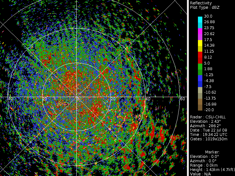
18 An example of a multicell as viewed by the CSU-CHILL radar
19 Corresponding image of differential reflectivity

, Quart. J.")
20 The more organized multicell thunderstorm Cells undergo the three stage lifecycle as they move through the storm Browning et al. (1976), Quart. J. Roy. Met. Soc.

21 Adapted from Houze (1993) Cloud Dynamics Supercell storm. Often accompanied by severe weather, wind, hail, tornadoes. Conceptual model identifies a single updraft. Ambient shear allows for storm-scale rotation, the mesocyclone. Characterizes the pre-tornadic phase. Mesocyclone is mainly at storm mid-levels at this stage.
 Fallout of heavy")
22 Supercell conceptual model CHARACTERISTICS Weak echo vault Leading shelf cloud denoting updraft -40 C Hail formation process, rapid growth by accretion as graupel pass through areas of large supercooled liquid water content Hail fallout Browning and Foote (1976) Fallout of heavy rain
23 29 June 2000 supercell storm observed during STEPS 2000 Dual-Doppler derived flow structure One large updraft, downdraft structure. Characteristic of supercell storm. Tessendorf et al. (2005), J. Atmos. Sci.

24 Cold outflow Tornadic phase Warm, moist inflow Key dynamics of the supercell Forward and rear flank downdrafts critical for generation of low level horizontal vorticity and then vertical vorticity through tilting. The tilting of the low level vorticity associated with the RFD/FFD converging with the warm inflow is a major source of vorticity for lower portion of the mesocyclone. Tornado is thought to form when lower portion of the mesocyclone intensifies via this mechanism. Lemon and Doswell (1979)

25 Mesocyclone and TVS signatures Example of supercell as viewed by the CSU-CHILL radar, 21 May 2004

26 What physical interpretations can you make here..
27 But here in Colorado Nonsupercell tornadoes prevail. Some times referred to as gustnadoes. Stretching of low-level horizontal vorticity by storm updraft Wakimoto and Wilson (1989)
28 Classic supercell, CG lightning predominately positive 29 June 2000 overview Positive CGs Max reflectivity ~ 70 dbz, Max updraft ~ 50 m/s
29 29 June charge structure (+CG supercell) Inverted tripole in precipitation; dipole in updraft Lower negative charge present in region of +CGs Wiens et al Radar data time: 2325 UTC NLDN data time: UTC LMA data time: 23:24:42-23:24:57 UTC

30 The Mesoscale Convective System Houze, Rutledge, Biggerstaff and Smull (1989), BAMS Driven by organized, linear convection forming on a feature like a surface front or outflow boundary. Convective line contains individual, intense convective elements that slope slightly rearward with height owing to vorticity considerations between ambient low level shear and cold pool. Rottuno, Klemp and Wiesman (1988).
31 From Newton and Newton, J. of Meteorology, 1959.
32 L Johnson and Hamilton (1988) Trailing stratiform region contains a number of interesting pressure features. Mesohigh Wake low
33 8 May 2009 In a more weakly-sheared environment, PV dynamics produces mid-level vortex in trailing stratiform region. Vortex produces asymmetric pattern to stratiform precipitation.
34 20 June 2007 MCS
35
36 Convection initiated along colliding gust fronts. Gust front clearly depicted in Zdr field from CSU-CHILL radar.
37
38
39
40
41
42
MICROPHYSICS COMPLEXITY EFFECTS ON STORM EVOLUTION AND ELECTRIFICATION
 MICROPHYSICS COMPLEXITY EFFECTS ON STORM EVOLUTION AND ELECTRIFICATION Blake J. Allen National Weather Center Research Experience For Undergraduates, Norman, Oklahoma and Pittsburg State University, Pittsburg,
DETAILED STORM SIMULATIONS BY A NUMERICAL CLOUD MODEL WITH ELECTRIFICATION AND LIGHTNING PARAMETERIZATIONS
 DETAILED STORM SIMULATIONS BY A NUMERICAL CLOUD MODEL WITH ELECTRIFICATION AND LIGHTNING PARAMETERIZATIONS Don MacGorman 1, Ted Mansell 1,2, Conrad Ziegler 1, Jerry Straka 3, and Eric C. Bruning 1,3 1
Roelof Bruintjes, Sarah Tessendorf, Jim Wilson, Rita Roberts, Courtney Weeks and Duncan Axisa WMA Annual meeting 26 April 2012
 Aerosol affects on the microphysics of precipitation development in tropical and sub-tropical convective clouds using dual-polarization radar and airborne measurements. Roelof Bruintjes, Sarah Tessendorf,
Evalua&ng Downdra/ Parameteriza&ons with High Resolu&on CRM Data
 Evalua&ng Downdra/ Parameteriza&ons with High Resolu&on CRM Data Kate Thayer-Calder and Dave Randall Colorado State University October 24, 2012 NOAA's 37th Climate Diagnostics and Prediction Workshop Convective
Supercell Thunderstorm Structure and Evolution
 Supercell Thunderstorm Structure and Evolution Supercellular Convection Most uncommon, but most dangerous storm type Produces almost all instances of very large hail and violent (EF4-EF5) tornadoes Highly
Left moving thunderstorms in a high Plains, weakly-sheared environment
 Left moving thunderstorms in a high Plains, weakly-sheared environment by John F. Weaver 1 and John F. Dostalek Cooperative Institute for Research in the Atmosphere, CIRA Colorado State University Fort
In a majority of ice-crystal icing engine events, convective weather occurs in a very warm, moist, tropical-like environment. aero quarterly qtr_01 10
 In a majority of ice-crystal icing engine events, convective weather occurs in a very warm, moist, tropical-like environment. 22 avoiding convective Weather linked to Ice-crystal Icing engine events understanding
Description of zero-buoyancy entraining plume model
 Influence of entrainment on the thermal stratification in simulations of radiative-convective equilibrium Supplementary information Martin S. Singh & Paul A. O Gorman S1 CRM simulations Here we give more
Storms Short Study Guide
 Name: Class: Date: Storms Short Study Guide Multiple Choice Identify the letter of the choice that best completes the statement or answers the question. 1. A(n) thunderstorm forms because of unequal heating
Weather Radar Basics
 Weather Radar Basics RADAR: Radio Detection And Ranging Developed during World War II as a method to detect the presence of ships and aircraft (the military considered weather targets as noise) Since WW
J4.1 CENTRAL NORTH CAROLINA TORNADOES FROM THE 16 APRIL 2011 OUTBREAK. Matthew Parker* North Carolina State University, Raleigh, North Carolina
 J4.1 CENTRAL NORTH CAROLINA TORNADOES FROM THE 16 APRIL 2011 OUTBREAK Matthew Parker* North Carolina State University, Raleigh, North Carolina Jonathan Blaes NOAA/National Weather Service, Raleigh, North
Regional Forecast Center Timişoara 15. Gh. Adam St., Timişoara, Romania, e-mail: cristi_nichita2004@yahoo.com
 Analele UniversităŃii din Oradea Seria Geografie Tom XX, no. 2/2010 (December), pp 197-203 ISSN 1221-1273, E-ISSN 2065-3409 Article no. 202106-492 SOME DOPPLER RADAR FEATURES OF SEVERE WEATHER IN SUPERCELLS
Goal: Understand the conditions and causes of tropical cyclogenesis and cyclolysis
 Necessary conditions for tropical cyclone formation Leading theories of tropical cyclogenesis Sources of incipient disturbances Extratropical transition Goal: Understand the conditions and causes of tropical
Frank and Charles Cohen Department of Meteorology The Pennsylvania State University University Park, PA, 16801 -U.S.A.
 376 THE SIMULATION OF TROPICAL CONVECTIVE SYSTEMS William M. Frank and Charles Cohen Department of Meteorology The Pennsylvania State University University Park, PA, 16801 -U.S.A. ABSTRACT IN NUMERICAL
Convective Clouds. Convective clouds 1
 Convective clouds 1 Convective Clouds Introduction Convective clouds are formed in vertical motions that result from the instability of the atmosphere. This instability can be caused by: a. heating at
How To Model An Ac Cloud
 Development of an Elevated Mixed Layer Model for Parameterizing Altocumulus Cloud Layers S. Liu and S. K. Krueger Department of Meteorology University of Utah, Salt Lake City, Utah Introduction Altocumulus
Basics of weather interpretation
 Basics of weather interpretation Safety at Sea Seminar, April 2 nd 2016 Dr. Gina Henderson Oceanography Dept., USNA ghenders@usna.edu Image source: http://earthobservatory.nasa.gov/naturalhazards/view.php?id=80399,
Trimodal cloudiness and tropical stable layers in simulations of radiative convective equilibrium
 GEOPHYSICAL RESEARCH LETTERS, VOL. 35, L08802, doi:10.1029/2007gl033029, 2008 Trimodal cloudiness and tropical stable layers in simulations of radiative convective equilibrium D. J. Posselt, 1 S. C. van
INTRODUCTION STORM CHRONOLOGY AND OBSERVATIONS
 THE MESOCYCLONE EVOLUTION OF THE WARREN, OKLAHOMA TORNADOES By Timothy P. Marshall and Erik N. Rasmussen (Reprinted from the 12th Conference on Severe Local Storms, American Meteorological Society, San
To my uncle Ruggero Marcello
 1 2 To my uncle Ruggero Marcello We wait, we wait, And the saints and martyrs wait, for those who shall be martyrs and saints. Destiny waits in the hand of God, shaping the still unshapen: I have seen
WEATHER THEORY Temperature, Pressure And Moisture
 WEATHER THEORY Temperature, Pressure And Moisture Air Masses And Fronts Weather Theory- Page 77 Every physical process of weather is a result of a heat exchange. The standard sea level temperature is 59
Convective Weather Maps
 Guide to using Convective Weather Maps Oscar van der Velde www.lightningwizard.com last modified: August 27th, 2007 Reproduction of this document or parts of it is allowed with permission. This document
Diurnal Cycle of Convection at the ARM SGP Site: Role of Large-Scale Forcing, Surface Fluxes, and Convective Inhibition
 Thirteenth ARM Science Team Meeting Proceedings, Broomfield, Colorado, March 31-April 4, 23 Diurnal Cycle of Convection at the ARM SGP Site: Role of Large-Scale Forcing, Surface Fluxes, and Convective
Chapter 6 - Cloud Development and Forms. Interesting Cloud
 Chapter 6 - Cloud Development and Forms Understanding Weather and Climate Aguado and Burt Interesting Cloud 1 Mechanisms that Lift Air Orographic lifting Frontal Lifting Convergence Localized convective
National Center for Atmospheric Research,* Boulder, Colorado V. TATARSKII
 MARCH 2009 M O R R I S O N E T A L. 991 Impact of Cloud Microphysics on the Development of Trailing Stratiform Precipitation in a Simulated Squall Line: Comparison of One- and Two-Moment Schemes H. MORRISON
Tornadoes Answer Sheet
 LEVEL 1 None LEVEL 2 Definitions for A Tornado Is Born anvil cloud: the upper portion of a cumulonimbus cloud that flattens spreads out, sometimes for hundreds of miles atmosphere: the mass of air surrounding
This chapter discusses: 1. Definitions and causes of stable and unstable atmospheric air. 2. Processes that cause instability and cloud development
 Stability & Cloud Development This chapter discusses: 1. Definitions and causes of stable and unstable atmospheric air 2. Processes that cause instability and cloud development Stability & Movement A rock,
Chapter 3: Weather Map. Weather Maps. The Station Model. Weather Map on 7/7/2005 4/29/2011
 Chapter 3: Weather Map Weather Maps Many variables are needed to described weather conditions. Local weathers are affected by weather pattern. We need to see all the numbers describing weathers at many
Chapter 3: Weather Map. Station Model and Weather Maps Pressure as a Vertical Coordinate Constant Pressure Maps Cross Sections
 Chapter 3: Weather Map Station Model and Weather Maps Pressure as a Vertical Coordinate Constant Pressure Maps Cross Sections Weather Maps Many variables are needed to described dweather conditions. Local
How do Scientists Forecast Thunderstorms?
 How do Scientists Forecast Thunderstorms? Objective In the summer, over the Great Plains, weather predictions often call for afternoon thunderstorms. While most of us use weather forecasts to help pick
Stability and Cloud Development. Stability in the atmosphere AT350. Why did this cloud form, whereas the sky was clear 4 hours ago?
 Stability and Cloud Development AT350 Why did this cloud form, whereas the sky was clear 4 hours ago? Stability in the atmosphere An Initial Perturbation Stable Unstable Neutral If an air parcel is displaced
Using Cloud-Resolving Model Simulations of Deep Convection to Inform Cloud Parameterizations in Large-Scale Models
 Using Cloud-Resolving Model Simulations of Deep Convection to Inform Cloud Parameterizations in Large-Scale Models S. A. Klein National Oceanic and Atmospheric Administration Geophysical Fluid Dynamics
ATMS 310 Jet Streams
 ATMS 310 Jet Streams Jet Streams A jet stream is an intense (30+ m/s in upper troposphere, 15+ m/s lower troposphere), narrow (width at least ½ order magnitude less than the length) horizontal current
Number of activated CCN as a key property in cloud-aerosol interactions. Or, More on simplicity in complex systems
 Number of activated CCN as a key property in cloud-aerosol interactions Or, More on simplicity in complex systems 1 Daniel Rosenfeld and Eyal Freud The Hebrew University of Jerusalem, Israel Uncertainties
MINI-SUPERCELL EVENT OF 23 OCTOBER 2004 IN THE MEMPHIS COUNTY WARNING AREA
 MINI-SUPERCELL EVENT OF 23 OCTOBER 2004 IN THE MEMPHIS COUNTY WARNING AREA Jonathan L. Howell* and Jason F. Beaman National Weather Service Forecast Office Memphis, Tennessee August 15, 2006 1. INTRODUCTION
Thunderstorm Basics. Updraft Characteristics (Rising Air) Downdraft Characteristics (Air Descends to the Ground)
 Downdraft Characteristics (Air Descends to the Ground)") Thunderstorm Basics Updraft Characteristics (Rising Air) Cumulus Tower Upward Cloud Motion Updraft Dominant Downdraft/Updraft Downdraft Dominant Rain-Free Base Downdraft Characteristics (Air Descends to
Thunderstorm Basics Updraft Characteristics (Rising Air) Cumulus Tower Upward Cloud Motion Updraft Dominant Downdraft/Updraft Downdraft Dominant Rain-Free Base Downdraft Characteristics (Air Descends to
A Review on the Uses of Cloud-(System-)Resolving Models
Resolving Models") A Review on the Uses of Cloud-(System-)Resolving Models Jeffrey D. Duda Since their advent into the meteorological modeling world, cloud-(system)-resolving models (CRMs or CSRMs) have become very important
A Review on the Uses of Cloud-(System-)Resolving Models Jeffrey D. Duda Since their advent into the meteorological modeling world, cloud-(system)-resolving models (CRMs or CSRMs) have become very important
Severe Weather Information
 Severe Weather Information TORNADO FACTS Canada gets more tornadoes than any other country with the exception of the United States. Tornadoes are rotating columns of high winds. Sometimes they move quickly
Lecture 3. Turbulent fluxes and TKE budgets (Garratt, Ch 2)
") Lecture 3. Turbulent fluxes and TKE budgets (Garratt, Ch 2) In this lecture How does turbulence affect the ensemble-mean equations of fluid motion/transport? Force balance in a quasi-steady turbulent boundary
Lecture 3. Turbulent fluxes and TKE budgets (Garratt, Ch 2) In this lecture How does turbulence affect the ensemble-mean equations of fluid motion/transport? Force balance in a quasi-steady turbulent boundary
Tropical Cloud Population
 Tropical Cloud Population Before Satellites Visual Observation View from and aircraft flying over the South China Sea Radiosonde Data Hot tower hypothesis Riehl & Malkus 1958 Satellite Observations Post
A Real Case Study of Using Cloud Analysis in Grid-point Statistical Interpolation Analysis and Advanced Research WRF Forecast System
 A Real Case Study of Using Cloud Analysis in Grid-point Statistical Interpolation Analysis and Advanced Research WRF Forecast System Ming Hu 1 and Ming Xue 1, 1 Center for Analysis and Prediction of Storms,
The formation of wider and deeper clouds through cold-pool dynamics
 The formation of wider and deeper clouds through cold-pool dynamics Linda Schlemmer, Cathy Hohenegger e for Meteorology, Hamburg 2013-09-03 Bergen COST Meeting Linda Schlemmer 1 / 27 1 Motivation 2 Simulations
Read and study the following information. After reading complete the review questions. Clouds
 Name: Pd: Read and study the following information. After reading complete the review questions. Clouds What are clouds? A cloud is a large collection of very tiny droplets of water or ice crystals. The
Lecture 7a: Cloud Development and Forms Why Clouds Form?
 Lecture 7a: Cloud Development and Forms Why Clouds Form? Clouds form when air rises and becomes saturated in response to adiabatic cooling. Why Clouds Form Cloud Types (from The Blue Planet ) Four Ways
Fundamentals of Climate Change (PCC 587): Water Vapor
: Water Vapor") Fundamentals of Climate Change (PCC 587): Water Vapor DARGAN M. W. FRIERSON UNIVERSITY OF WASHINGTON, DEPARTMENT OF ATMOSPHERIC SCIENCES DAY 2: 9/30/13 Water Water is a remarkable molecule Water vapor
Fundamentals of Climate Change (PCC 587): Water Vapor DARGAN M. W. FRIERSON UNIVERSITY OF WASHINGTON, DEPARTMENT OF ATMOSPHERIC SCIENCES DAY 2: 9/30/13 Water Water is a remarkable molecule Water vapor
Cloud-Resolving Simulations of Convection during DYNAMO
 Cloud-Resolving Simulations of Convection during DYNAMO Matthew A. Janiga and Chidong Zhang University of Miami, RSMAS 2013 Fall ASR Workshop Outline Overview of observations. Methodology. Simulation results.
GCMs with Implicit and Explicit cloudrain processes for simulation of extreme precipitation frequency
 GCMs with Implicit and Explicit cloudrain processes for simulation of extreme precipitation frequency In Sik Kang Seoul National University Young Min Yang (UH) and Wei Kuo Tao (GSFC) Content 1. Conventional
Chapter 6: Cloud Development and Forms
 Chapter 6: Cloud Development and Forms (from The Blue Planet ) Why Clouds Form Static Stability Cloud Types Why Clouds Form? Clouds form when air rises and becomes saturated in response to adiabatic cooling.
Meteorology: Weather and Climate
 Meteorology: Weather and Climate Large Scale Weather Systems Lecture 1 Tropical Cyclones: Location and Structure Prof. Roy Thompson Crew building Large-scale Weather Systems Tropical cyclones (1-2) Location,
BASIC SPOTTERS FIELD GUIDE BASIC SPOTTERS FIELD GUIDE BASIC SPOTTERS FIELD GUIDE BASIC SPOTTERS FIELD GUIDE
 NATIONAL OCEANIC AND ATMOSPHERIC ADMINISTRATION BASIC SPOTTERS FIELD GUIDE BASIC SPOTTERS FIELD GUIDE BASIC SPOTTERS FIELD GUIDE BASIC SPOTTERS FIELD GUIDE U.S. DEPARTMENT OF COMMERCE U.S. DEPARTMENT OF
Lecture 7a: Cloud Development and Forms
 Lecture 7a: Cloud Development and Forms Why Clouds Form Cloud Types (from The Blue Planet ) Why Clouds Form? Clouds form when air rises and becomes saturated in response to adiabatic cooling. Four Ways
Lecture 4: Pressure and Wind
 Lecture 4: Pressure and Wind Pressure, Measurement, Distribution Forces Affect Wind Geostrophic Balance Winds in Upper Atmosphere Near-Surface Winds Hydrostatic Balance (why the sky isn t falling!) Thermal
Nowcasting Thunderstorm Potential from Satellite
 Nowcasting Thunderstorm Potential from Satellite Robert M Rabin NOAA/National Severe Storms Laboratory Norman, OK USA Cooperative Institute for Meteorological Satellite Studies University of Wisconsin
Scientific report ; WR 2009-04 Detection of Cb and TCu clouds using MSG-SEVIRI cloud physical properties and weather radar observations
 Scientific report ; WR 2009-04 Detection of Cb and TCu clouds using MSG-SEVIRI cloud physical properties and weather radar observations Cintia Carbajal Henken, Maurice Schmeits, Erwin Wolters and Rob Roebeling
Clouds for pilots. Ed Williams. http://williams.best.vwh.net/
 Clouds for pilots Ed Williams http://williams.best.vwh.net/ Clouds are important to pilots! Many of our weather problems are associated with clouds: Fog Thunderstorms Cloud In flight icing Cloud physics
A Romanian Forecast and Training Experience, August 2002
 A Romanian Forecast and Training Experience, August 2002 Introduction Leslie R. Lemon and Aurora Stan-Sion During 2002 Romania has gone through a modernization program for its weather services similar
Weather Help - NEXRAD Radar Maps. Base Reflectivity
 Weather Help - NEXRAD Radar Maps Base Reflectivity Base Reflectivity Severe Thunderstorm/Torna do Watch Areas 16 levels depicted with colors from dark green (very light) to red (extreme) that indicate
The Ideal Gas Law. Gas Constant. Applications of the Gas law. P = ρ R T. Lecture 2: Atmospheric Thermodynamics
 Lecture 2: Atmospheric Thermodynamics Ideal Gas Law (Equation of State) Hydrostatic Balance Heat and Temperature Conduction, Convection, Radiation Latent Heating Adiabatic Process Lapse Rate and Stability
Fog and Cloud Development. Bows and Flows of Angel Hair
 Fog and Cloud Development Bows and Flows of Angel Hair 1 Ch. 5: Condensation Achieving Saturation Evaporation Cooling of Air Adiabatic and Diabatic Processes Lapse Rates Condensation Condensation Nuclei
8B.6 A DETAILED ANALYSIS OF SPC HIGH RISK OUTLOOKS, 2003-2009
 8B.6 A DETAILED ANALYSIS OF SPC HIGH RISK OUTLOOKS, 2003-2009 Jason M. Davis*, Andrew R. Dean 2, and Jared L. Guyer 2 Valparaiso University, Valparaiso, IN 2 NOAA/NWS Storm Prediction Center, Norman, OK.
UNIT 6a TEST REVIEW. 1. A weather instrument is shown below.
 UNIT 6a TEST REVIEW 1. A weather instrument is shown below. Which weather variable is measured by this instrument? 1) wind speed 3) cloud cover 2) precipitation 4) air pressure 2. Which weather station
Unified Cloud and Mixing Parameterizations of the Marine Boundary Layer: EDMF and PDF-based cloud approaches
 DISTRIBUTION STATEMENT A. Approved for public release; distribution is unlimited. Unified Cloud and Mixing Parameterizations of the Marine Boundary Layer: EDMF and PDF-based cloud approaches Joao Teixeira
1. Specific Differential Phase (KDP)
") 1. Specific Differential Phase (KDP) Instructor Notes: Welcome to the dual polarization radar course. I am Clark Payne with the Warning Decision Training Branch. This lesson is part of the dual-pol products
1. Specific Differential Phase (KDP) Instructor Notes: Welcome to the dual polarization radar course. I am Clark Payne with the Warning Decision Training Branch. This lesson is part of the dual-pol products
Probabilistic forecasts of winter thunderstorms around Schiphol Airport using Model Output Statistics
 Technical report ; TR-300 Probabilistic forecasts of winter thunderstorms around Schiphol Airport using Model Output Statistics Aimée Slangen De Bilt, 2008 KNMI technical report = technisch rapport; TR-300
39th International Physics Olympiad - Hanoi - Vietnam - 2008. Theoretical Problem No. 3
 CHANGE OF AIR TEMPERATURE WITH ALTITUDE, ATMOSPHERIC STABILITY AND AIR POLLUTION Vertical motion of air governs many atmospheric processes, such as the formation of clouds and precipitation and the dispersal
Various Implementations of a Statistical Cloud Scheme in COSMO model
 2 Working Group on Physical Aspects 61 Various Implementations of a Statistical Cloud Scheme in COSMO model Euripides Avgoustoglou Hellenic National Meteorological Service, El. Venizelou 14, Hellinikon,
OBSERVATIONS FROM THE APRIL 13 2004 WAKE LOW DAMAGING WIND EVENT IN SOUTH FLORIDA. Robert R. Handel and Pablo Santos NOAA/NWS, Miami, Florida ABSTRACT
 OBSERVATIONS FROM THE APRIL 13 2004 WAKE LOW DAMAGING WIND EVENT IN SOUTH FLORIDA Robert R. Handel and Pablo Santos NOAA/NWS, Miami, Florida ABSTRACT On Tuesday, April 13, 2004, a high wind event swept
Cover Photo - Alan Moller
 Cover Photo - Alan Moller The Spotter s Role I. INTRODUCTION The National Weather Service (NWS) has a number of devices for detecting severe thunderstorms. Included in these are radar, satellite, and lightning
6 th Grade Science Assessment: Weather & Water Select the best answer on the answer sheet. Please do not make any marks on this test.
 Select the be answer on the answer sheet. Please do not make any marks on this te. 1. Weather is be defined as the A. changes that occur in cloud formations from day to day. B. amount of rain or snow that
P1.2 ASSESSMENT OF ANTICYCLONIC SUPERCELL ENVIRONMENTS USING CLOSE PROXIMITY SOUNDINGS FROM THE RUC MODEL
 P1.2 ASSESSMENT OF ANTICYCLONIC SUPERCELL ENVIRONMENTS USING CLOSE PROXIMITY SOUNDINGS FROM THE RUC MODEL 1. INTRODUCTION Roger Edwards 1, Richard L. Thompson and Corey M. Mead Storm Prediction Center,
Wind shear - poses challenges and dangers at the most critical stages of flight
 Wind shear - poses challenges and dangers at the most critical stages of flight Authored and illustrated by Sari Jay June 2009 Introduction Over 40 years ago, in the 1960s, low level wind shear was just
A quick look at clouds: what is a cloud, what is its origin and what can we predict and model about its destiny?
 A quick look at clouds: what is a cloud, what is its origin and what can we predict and model about its destiny? Paul DeMott Colorado State University A look at clouds: what is a cloud, what is its origin
Energy & Conservation of Energy. Energy & Radiation, Part I. Monday AM, Explain: Energy. Thomas Birner, ATS, CSU
 Monday AM, Explain: Energy MONDAY: energy in and energy out on a global scale Energy & Conservation of Energy Energy & Radiation, Part I Energy concepts: What is energy? Conservation of energy: Can energy
MountainZebra: Real-Time Archival and 4D Visualization of Radar Volumes Over Complex Terrain
 MountainZebra: Real-Time Archival and D Visualization of Radar Volumes Over Complex Terrain Curtis James, Stacy Brodzik, Harry Edmon, Robert Houze, and Sandra Yuter Department of Atmospheric Sciences,
NOTES AND CORRESPONDENCE. Observations of a Severe Left Moving Thunderstorm
 500 WEATHER AND FORECASTING VOLUME 16 NOTES AND CORRESPONDENCE Observations of a Severe Left Moving Thunderstorm LEWIS D. GRASSO AND ERIC R. HILGENDORF Cooperative Institute for Research in the Atmosphere,
Vortical Swirls in Hurricane Eye Clouds
 3144 MONTHLY WEATHER REVIEW VOLUME 130 Vortical Swirls in Hurricane Eye Clouds JAMES P. KOSSIN Cooperative Institute for Meteorological Satellite Studies, University of Wisconsin Madison, Madison, Wisconsin
Humidity, Condensation, Clouds, and Fog. Water in the Atmosphere
 Humidity, Condensation, Clouds, and Fog or Water in the Atmosphere The Hydrologic Cycle Where the Water Exists on Earth Evaporation From the Oceans and Land The Source of Water Vapor for the Atmosphere
6.4 THE SIERRA ROTORS PROJECT, OBSERVATIONS OF MOUNTAIN WAVES. William O. J. Brown 1 *, Stephen A. Cohn 1, Vanda Grubiši 2, and Brian Billings 2
 6.4 THE SIERRA ROTORS PROJECT, OBSERVATIONS OF MOUNTAIN WAVES William O. J. Brown 1 *, Stephen A. Cohn 1, Vanda Grubiši 2, and Brian Billings 2 1 National Center for Atmospheric Research, Boulder, Colorado.
7613-1 - Page 1. Weather Unit Exam Pre-Test Questions
 Weather Unit Exam Pre-Test Questions 7613-1 - Page 1 Name: 1) Equal quantities of water are placed in four uncovered containers with different shapes and left on a table at room temperature. From which
Clouds. A simple scientific explanation for the weather-curious. By Kira R. Erickson
 Clouds A simple scientific explanation for the weather-curious By Kira R. Erickson Table of Contents 1 3 4 INTRO 2 Page 3 How Clouds Are Formed Types of Clouds Clouds and Weather More Information Page
HYDROLOGICAL CYCLE Vol. II - Formation of Precipitation - L.T. Matveev, Yu. L. Matveev
 FORMATION OF PRECIPITATION L.T.Matveev Department of Meteorology and Climatology, Russian State Hydrometeorological University, St. Petersburg, Russia Yu L.Matveev Department of Applied Mathematics and
-ma, we see that the acceleration of a falling object (g) is g=g*m
 is g=g*m") Forces of Motion And Sir Isaac Newton Sir Isaac Newton, the father of mechanics, is one of the most important scientists who ever lived, changing the standards by which scientists think. His genius in
Forces of Motion And Sir Isaac Newton Sir Isaac Newton, the father of mechanics, is one of the most important scientists who ever lived, changing the standards by which scientists think. His genius in
4.2 A VIRTUAL TORNADIC THUNDERSTORM ENABLING STUDENTS TO CONSTRUCT KNOWLEDGE ABOUT STORM DYNAMICS THROUGH DATA COLLECTION AND ANALYSIS
 4.2 A VIRTUAL TORNADIC THUNDERSTORM ENABLING STUDENTS TO CONSTRUCT KNOWLEDGE ABOUT STORM DYNAMICS THROUGH DATA COLLECTION AND ANALYSIS William A. Gallus, Jr*., Cinzia Cervato, Carolina Cruz-Neira, Galen
SURFACE SOURCE OF ICE PARTICLES IN MOUNTAIN CLOUDS
 SURFACE SOURCE OF ICE PARTICLES IN MOUNTAIN CLOUDS Gabor Vali, Bart Geerts, David Leon and Jefferson R. Snider. Department of Atmospheric Science, University of Wyoming Laramie, WY USA.
Cloud seeding. Frequently Asked Questions. What are clouds and how are they formed? How do we know cloud seeding works in Tasmania?
 What are clouds and how are they formed? Clouds are composed of water droplets and sometimes ice crystals. Clouds form when air that is rich in moisture near the Earth s surface rises higher into the atmosphere,
12.307. 1 Convection in water (an almost-incompressible fluid)
") 12.307 Convection in water (an almost-incompressible fluid) John Marshall, Lodovica Illari and Alan Plumb March, 2004 1 Convection in water (an almost-incompressible fluid) 1.1 Buoyancy Objects that are
12.307 Convection in water (an almost-incompressible fluid) John Marshall, Lodovica Illari and Alan Plumb March, 2004 1 Convection in water (an almost-incompressible fluid) 1.1 Buoyancy Objects that are
Continental and Marine Low-level Cloud Processes and Properties (ARM SGP and AZORES) Xiquan Dong University of North Dakota
 Xiquan Dong University of North Dakota") Continental and Marine Low-level Cloud Processes and Properties (ARM SGP and AZORES) Xiquan Dong University of North Dakota Outline 1) Statistical results from SGP and AZORES 2) Challenge and Difficult
Continental and Marine Low-level Cloud Processes and Properties (ARM SGP and AZORES) Xiquan Dong University of North Dakota Outline 1) Statistical results from SGP and AZORES 2) Challenge and Difficult
Climate Models: Uncertainties due to Clouds. Joel Norris Assistant Professor of Climate and Atmospheric Sciences Scripps Institution of Oceanography
 Climate Models: Uncertainties due to Clouds Joel Norris Assistant Professor of Climate and Atmospheric Sciences Scripps Institution of Oceanography Global mean radiative forcing of the climate system for
Parameterization of Cumulus Convective Cloud Systems in Mesoscale Forecast Models
 DISTRIBUTION STATEMENT A. Approved for public release; distribution is unlimited. Parameterization of Cumulus Convective Cloud Systems in Mesoscale Forecast Models Yefim L. Kogan Cooperative Institute
Mid latitude Cyclonic Storm System. 08 _15 ab. jpg
 Mid latitude Cyclonic Storm System 08 _15 ab. jpg Mid Latitude Cyclone Storm System (MLCSS) It has several names. Cyclone, Cyclonic Storm, Cyclonic System, Depression. Cyclonic Storms are the weather maker
Usama Anber 1, Shuguang Wang 2, and Adam Sobel 1,2,3
 Response of Atmospheric Convection to Vertical Wind Shear: Cloud Resolving Simulations with Parameterized Large-Scale Circulation. Part I: Specified Radiative Cooling. Usama Anber 1, Shuguang Wang 2, and
Center for Analysis and Prediction of Storms, and School of Meteorology, University of Oklahoma, Norman, Oklahoma KEITH BREWSTER
 FEBRUARY 2006 H U E T A L. 675 3DVAR and Cloud Analysis with WSR-88D Level-II Data for the Prediction of the Fort Worth, Texas, Tornadic Thunderstorms. Part I: Cloud Analysis and Its Impact MING HU AND
Climate Extremes Research: Recent Findings and New Direc8ons
 Climate Extremes Research: Recent Findings and New Direc8ons Kenneth Kunkel NOAA Cooperative Institute for Climate and Satellites North Carolina State University and National Climatic Data Center h#p://assessment.globalchange.gov
Including thermal effects in CFD simulations
 Including thermal effects in CFD simulations Catherine Meissner, Arne Reidar Gravdahl, Birthe Steensen catherine@windsim.com, arne@windsim.com Fjordgaten 15, N-125 Tonsberg hone: +47 8 1800 Norway Fax:
Atmospheric Stability & Cloud Development
 Atmospheric Stability & Cloud Development Stable situations a small change is resisted and the system returns to its previous state Neutral situations a small change is neither resisted nor enlarged Unstable
P10.145 POTENTIAL APPLICATIONS OF A CONUS SOUNDING CLIMATOLOGY DEVELOPED AT THE STORM PREDICTION CENTER
 P10.145 POTENTIAL APPLICATIONS OF A CONUS SOUNDING CLIMATOLOGY DEVELOPED AT THE STORM PREDICTION CENTER Jaret W. Rogers*, Richard L. Thompson, and Patrick T. Marsh NOAA/NWS Storm Prediction Center Norman,
Not all clouds are easily classified! Cloud Classification schemes. Clouds by level 9/23/15
 Cloud Classification schemes 1) classified by where they occur (for example: high, middle, low) 2) classified by amount of water content and vertical extent (thick, thin, shallow, deep) 3) classified by
Harvard wet deposition scheme for GMI
 1 Harvard wet deposition scheme for GMI by D.J. Jacob, H. Liu,.Mari, and R.M. Yantosca Harvard University Atmospheric hemistry Modeling Group Februrary 2000 revised: March 2000 (with many useful comments
CFD Based Air Flow and Contamination Modeling of Subway Stations
 CFD Based Air Flow and Contamination Modeling of Subway Stations Greg Byrne Center for Nonlinear Science, Georgia Institute of Technology Fernando Camelli Center for Computational Fluid Dynamics, George
How To Model The Weather
 Convection Resolving Model (CRM) MOLOCH 1-Breve descrizione del CRM sviluppato all ISAC-CNR 2-Ipotesi alla base della parametrizzazione dei processi microfisici Objectives Develop a tool for very high