Jumping Ahead. Meaningful Metadata Modernization. Jordan Erker, Erin Mansell & Christine Adams GeoDiscover Alberta Office October 28,2015
|
|
|
- Verity Thomas
- 7 years ago
- Views:
Transcription
1 Jumping Ahead Meaningful Metadata Modernization Jordan Erker, Erin Mansell & Christine Adams GeoDiscover Alberta Office October 28,2015

2 GEOSPATIAL DATA PARTNERSHIPS TECHNOLOGY PEOPLE GEOSPATIAL DATA PARTNERSHIPS TECHNOLOGY PEOPLE GEOSPATIAL DATA PARTNERSHIPS TECHNOLOGY PEOPLE GEOSPATIAL DATA PARTNERSHIPS TECHNOLOGY PEOPLE GEOSPATIAL DATA PARTNERSHIPS TECHNOLOGY PEOPLE GEOSPATIAL DATA PARTNERSHIPS TECHNOLOGY PEOPLE GEOSPATIAL DATA PARTNERSHIPS TECHNOLOGY PEOPLE GEOSPATIAL DATA PARTNERSHIPS TECHNOLOGY PEOPLE GEOSPATIAL DATA PARTNERSHIPS TECHNOLOGY PEOPLE GEOSPATIAL DATA PARTNERSHIPS TECHNOLOGY PEOPLE GEOSPATIAL DATA PARTNERSHIPS TECHNOLOGY PEOPLE GEOSPATIAL DATA PARTNERSHIPS TECHNOLOGY PEOPLE GEOSPATIAL DATA PARTNERSHIPS TECHNOLOGY PEOPLE GEOSPATIAL DATA PARTNERSHIPS TECHNOLOGY PEOPLE GEOSPATIAL DATA PARTNERSHIPS TECHNOLOGY PEOPLE GEOSPATIAL DATA PARTNERSHIPS TECHNOLOGY PEOPLE GEOSPATIAL DATA PARTNERSHIPS TECHNOLOGY PEOPLE GEOSPATIAL DATA PARTNERSHIPS TECHNOLOGY PEOPLE GEOSPATIAL DATA GEODISCOVER ALBERTA PARTNERSHIPS TECHNOLOGY PEOPLE GEOSPATIAL DATA PARTNERSHIPS TECHNOLOGY PEOPLE GEOSPATIAL DATA PARTNERSHIPS TECHNOLOGY PEOPLE GEOSPATIAL DATA PARTNERSHIPS TECHNOLOGY PEOPLE Enabling GEOSPATIAL barrier-free DATA access PARTNERSHIPS to government TECHNOLOGY geospatial data, PEOPLE fostering GEOSPATIAL DATA PARTNERSHIPS TECHNOLOGY innovation, and PEOPLE supplying GEOSPATIAL expertise DATA in spatial PARTNERSHIPS knowledge areas TECHNOLOGY PEOPLE GEOSPATIAL DATA PARTNERSHIPS TECHNOLOGY PEOPLE GEOSPATIAL DATA PARTNERSHIPS TECHNOLOGY PEOPLE GEOSPATIAL DATA PARTNERSHIPS TECHNOLOGY PEOPLE GEOSPATIAL DATA PARTNERSHIPS TECHNOLOGY PEOPLE GEOSPATIAL DATA PARTNERSHIPS TECHNOLOGY PEOPLE GEOSPATIAL DATA PARTNERSHIPS TECHNOLOGY PEOPLE GEOSPATIAL DATA PARTNERSHIPS TECHNOLOGY PEOPLE GEOSPATIAL DATA PARTNERSHIPS TECHNOLOGY PEOPLE GEOSPATIAL DATA


3 EMPOWERMENT The GEODISCOVER Alberta Office Responsible for Alberta s SPATIAL DATA INFRASTRUCTURE the Canadian Geospatial Data Infrastructure is made up of people, partnerships, geospatial content, and technology with an aim to facilitate better policy and decision making -Natural Resources Canada, 2005 The Components of an SDI PEOPLE PARTNERSHIPS COLLABORATION TRANSPARENCY GEOSPATIAL DATA TECHNOLOGY SHARING

4 GeoDiscover Alberta Office at your service RESOURCES & SERVICES Community of Practices GeoDiscover Portal & Web Map Open Data Collection Published Government Spatial Data Collection Spatial Standards & Best Practices Educational Supports


5 STANDARDS GEOSPATIAL METADATA The province of Alberta manages significant spatial data assets on behalf of Albertans. Managing your data as an asset means recognizing metadata as key component of a geospatial dataset. GDA is working to modernize Alberta s metadata profile from FGDC to ISO NAP to ensure these data assets are well maintained.

6 GEOSPATIAL DATA CSDGM-FGDC ISO NAP METADATA SERVICES CATALOGUES TECHNOLOGY INTEGRATION GEOSPATIAL DATA CSDGM-FGDC ISO NAP METADATA SERVICES CATALOGUES TECHNOLOGY INTEGRATION GEOSPATIAL DATA CSDGM-FGDC ISO NAP METADATA SERVICES CATALOGUES TECHNOLOGY INTEGRATION GEOSPATIAL DATA CSDGM-FGDC ISO NAP METADATA SERVICES CATALOGUES TECHNOLOGY INTEGRATION GEOSPATIAL DATA CSDGM-FGDC ISO NAP METADATA SERVICES CATALOGUES TECHNOLOGY INTEGRATION GEOSPATIAL DATA CSDGM-FGDC ISO NAP METADATA SERVICES CATALOGUES TECHNOLOGY INTEGRATION GEOSPATIAL DATA CSDGM-FGDC ISO NAP METADATA SERVICES CATALOGUES TECHNOLOGY INTEGRATION GEOSPATIAL DATA CSDGM-FGDC ISO NAP METADATA SERVICES CATALOGUES TECHNOLOGY INTEGRATION GEOSPATIAL DATA CSDGM-FGDC ISO NAP METADATA SERVICES CATALOGUES TECHNOLOGY INTEGRATION GEOSPATIAL DATA CSDGM-FGDC ISO NAP METADATA SERVICES METADATA & GDA CATALOGUES TECHNOLOGY INTEGRATION GEOSPATIAL DATA CSDGM-FGDC ISO NAP METADATA SERVICES CATALOGUES TECHNOLOGY INTEGRATION GEOSPATIAL DATA CSDGM-FGDC ISO NAP METADATA SERVICES CATALOGUES We never TECHNOLOGY met a data INTEGRATION we didn t like GEOSPATIAL DATA CSDGM-FGDC ISO NAP METADATA SERVICES CATALOGUES TECHNOLOGY INTEGRATION GEOSPATIAL DATA CSDGM-FGDC ISO NAP METADATA SERVICES CATALOGUES TECHNOLOGY INTEGRATION GEOSPATIAL DATA CSDGM-FGDC ISO NAP METADATA SERVICES CATALOGUES TECHNOLOGY INTEGRATION GEOSPATIAL DATA CSDGM-FGDC ISO NAP METADATA SERVICES CATALOGUES TECHNOLOGY INTEGRATION GEOSPATIAL DATA CSDGM-FGDC ISO NAP METADATA SERVICES CATALOGUES TECHNOLOGY INTEGRATION GEOSPATIAL DATA CSDGM-FGDC ISO NAP METADATA SERVICES CATALOGUES TECHNOLOGY INTEGRATION GEOSPATIAL DATA CSDGM-FGDC ISO NAP 19115

7 METADATA ESSENTIAL TO OUR PORTAL Portal SUBMITS Metadata Records COLLECTS Metadata Records USES Metadata Records Partners Viewer


8 METADATA ESSENTIAL TO YOUR ORGANIZATION Document Data Holdings Standardize Business Rules Reduce Duplication Increase sharing Reduce Liability

9 Making the Jump Modernizing Alberta s geospatial metadata profile. Even if you are on the right track you will get run over if you just sit there. Will Rogers The goal of modernizing the Alberta s geospatial metadata profile from a customized version of FGDC:CGDSM to standard instance (not customized) of ISO NAP is to ensure Alberta stays in step with the rest of Canada and that the Alberta has the best resources available to document spatial data assets.
 of ISO NAP 19115-1 is to ensure Alberta stays in step with the rest")
10 THE FIRST JUMP EXTERNAL RECORDS CROSS- MINISTRY PROJECT TEAM AUGMENT WITH SUPPORT FROM ESRI


11 CHANGING PROFILES Ensures Alberta stays current and in step with the rest of Canada.

12 REASONS TO JUMP COMPLICATIONS DUE TO CUSTOMIZED PROFILE FGDC DEPRECATION NO FORTHCOMING ENHANCEMENTS OPPORTUNITY FOR METADATA QUALITY ENHANCEMENTS

13 CITATION DATA QUALITY EXTENT FEATURE CATALOGUE GEOMETRY LINEAGE METADATA REFERENCE SYSTEM SERVICES CITATION DATA QUALITY EXTENT FEATURE CATALOGUE GEOMETRY LINEAGE METADATA REFERENCE SYSTEM SERVICES CITATION DATA QUALITY EXTENT FEATURE CATALOGUE GEOMETRY LINEAGE METADATA REFERENCE SYSTEM SERVICES CITATION DATA QUALITY EXTENT FEATURE CATALOGUE GEOMETRY LINEAGE METADATA REFERENCE SYSTEM SERVICES CITATION DATA QUALITY EXTENT FEATURE CATALOGUE GEOMETRY LINEAGE METADATA REFERENCE SYSTEM SERVICES CITATION DATA QUALITY EXTENT FEATURE CATALOGUE GEOMETRY LINEAGE METADATA REFERENCE SYSTEM SERVICES CITATION DATA QUALITY EXTENT FEATURE CATALOGUE GEOMETRY LINEAGE METADATA REFERENCE SYSTEM SERVICES CITATION DATA QUALITY EXTENT FEATURE CATALOGUE GEOMETRY LINEAGE METADATA REFERENCE SYSTEM SERVICES CITATION DATA QUALITY EXTENT FEATURE CATALOGUE GEOMETRY LINEAGE METADATA REFERENCE SYSTEM ISO NAP SERVICES CITATION DATA QUALITY EXTENT FEATURE CATALOGUE GEOMETRY LINEAGE METADATA REFERENCE SYSTEM SERVICES CITATION DATA QUALITY EXTENT FEATURE CATALOGUE GEOMETRY LINEAGE METADATA REFERENCE Going SYSTEM modular SERVICES with your CITATION metadata DATA QUALITY EXTENT FEATURE CATALOGUE GEOMETRY LINEAGE METADATA REFERENCE SYSTEM SERVICES CITATION DATA QUALITY EXTENT FEATURE CATALOGUE GEOMETRY LINEAGE METADATA REFERENCE SYSTEM SERVICES CITATION DATA QUALITY EXTENT FEATURE CATALOGUE GEOMETRY LINEAGE METADATA REFERENCE SYSTEM SERVICES CITATION DATA QUALITY EXTENT FEATURE CATALOGUE GEOMETRY LINEAGE METADATA REFERENCE SYSTEM SERVICES CITATION DATA QUALITY EXTENT FEATURE CATALOGUE GEOMETRY LINEAGE METADATA REFERENCE SYSTEM SERVICES CITATION DATA QUALITY EXTENT FEATURE CATALOGUE GEOMETRY LINEAGE METADATA REFERENCE SYSTEM SERVI

14 MEANINGFUL METADATA KNOWLEDGE MANAGEMENT Connects data producer to users Helps manage data as an asset DOCUMENTATION Improves findability and accessibility Makes tacit knowledge of SMEs tangible ISO NAP Designed to support modern sharing Custom xml encoding for the profile

15 HOW IT WORKS ISO is organized into SECTIONS & PACKAGES (in xml) SECTION: Groupings of similar information PACKAGE: Logical groupings of elements found in multiple locations within sections

16 SECTIONS ILLUSTRATION DATA QUALITY METADATA ENTITY ID INFO


17 ADVANTAGES MAINTAINED FLEXIBLE STANDARD INTER- NATIONALLY RECOGNIZED INCREASING TOOLSETS & SUPPORTS SUPPORTS SERVICES (WMS, WFS)


18 RESOURCES Natural Resources Canada NOAA FGDC ESRI MetadataToolkit

19 SWITCHING PROFILES CORRELATION Not all elements directly correlate Build a crosswalk ASSESSMENT Review mandatory elements Examine business requirements Evaluate best practices against organizational needs IMPLEMENTATION Ensure consensus on how to document Not all tools for conversion are equal Test what will give you the best results (FME, ArcCatalog, Manual, other)


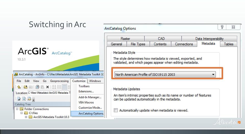
20 Switching in Arc

21 JUMPING AHEAD SUPPORTS QUALITY ASSURANCE ENGAGED SMES An Engaged Community Of Practice TOOLS & RESOURCES
22 QUESTIONS GeoDiscover Alberta Alberta s Open Geospatial Office
EXPLORING AND SHARING GEOSPATIAL INFORMATION THROUGH MYGDI EXPLORER
 EXPLORING AND SHARING GEOSPATIAL INFORMATION THROUGH MYGDI EXPLORER Subashini Panchanathan Malaysian Centre For Geospatial Data Infrastructure ( MaCGDI ) Ministry of National Resources and Environment
EEOS 381 - Spatial Databases and GIS Applications
 EEOS 381 - Spatial Databases and GIS Applications Lecture 9 Metadata What is Metadata? Data about data Description of a (GIS) dataset What it represents Who created it? When? How? Format Field definitions
Adventures in Metadata: Addressing the Federal Geographic Data Committee (FGDC) Standard
 Standard") Adventures in Metadata: Addressing the Federal Geographic Data Committee (FGDC) Standard Allison Gaylord Owner / GIS Specialist Nuna Technologies POB 1483 Homer, AK 99603 907-399-1120 www.nunatech.com
Adventures in Metadata: Addressing the Federal Geographic Data Committee (FGDC) Standard Allison Gaylord Owner / GIS Specialist Nuna Technologies POB 1483 Homer, AK 99603 907-399-1120 www.nunatech.com
FGDC, Meet the DDI. Adding Geospatial Metadata to a Numeric Data Catalog. Julie Linden Yale University
 FGDC, Meet the DDI Adding Geospatial Metadata to a Numeric Data Catalog Julie Linden Yale University Outline StatCat: numeric data catalog Why add geospatial metadata? FGDC/DDI crosswalk Implementation
VGIS HANDBOOK PART 2 - STANDARDS SECTION D METADATA STANDARD
 VGIS HANDBOOK PART 2 - STANDARDS SECTION D Vermont Geographic Information System Standard History November 15, 1989 version 1a - Section A: Digitizing Data adopted by Policy Advisory Board January, 1991
North American Profile for Geospatial Metadata status report
 North American Profile for Geospatial Metadata status report David Danko ESRI, Washington, DC Jean Brodeur Natural Resources Canada, Centre for Topographic Information, Sherbrooke What is a profile? ISO
GEOGRAPHIC INFORMATION GATEWAY New York Department of State (NYDOS) data acceptance & metadata standards
 data acceptance & metadata standards") GEOGRAPHIC INFORMATION GATEWAY New York Department of State (NYDOS) data acceptance & metadata standards 1. DATA ACCEPTANCE STANDARDS The following describes the data acceptance standards for data included
GEOGRAPHIC INFORMATION GATEWAY New York Department of State (NYDOS) data acceptance & metadata standards 1. DATA ACCEPTANCE STANDARDS The following describes the data acceptance standards for data included
CAPITAL REGION GIS SPATIAL DATA DEMONSTRATION PROJECT
 CAPITAL REGION GIS SPATIAL DATA DEMONSTRATION PROJECT DRAFT January 2013 Prepared by: O2 Planning + Design, Inc. The information contained in this document has been compiled by O2 Planning + Design Inc.
GIS Data Quality and Evaluation. Tomislav Sapic GIS Technologist Faculty of Natural Resources Management Lakehead University
 GIS Data Quality and Evaluation Tomislav Sapic GIS Technologist Faculty of Natural Resources Management Lakehead University The quality of GIS data gains in importance when considering some of the main
Scholars GeoPortal: Since 2002, Scholars Portal has hosted shared collections...
 Scholars GeoPortal: A New Platform for Geospatial Data Discovery, Exploration and Access in Ontario Universities by Elizabeth Hill and Leanne Trimble 1 OCUL Abstract The need to support and promote the
Leveraging Metadata Standards in ArcGIS for Interoperability
 Esri International User Conference San Diego, California Technical Workshops July 26, 2012 Leveraging Metadata Standards in ArcGIS for Interoperability David Danko Aleta Vienneau Leveraging Metadata Standards
Andrea Buffam, Natural Resources Canada Canadian Metadata Forum National Library of Canada Ottawa, Ontario September 19 20, 2003
 Geospatial Metadata Andrea Buffam, Natural Resources Canada Canadian Metadata Forum National Library of Canada Ottawa, Ontario September 19 20, 2003 The Presentation - Geospatial Metadata This presentation
Spatial Information Data Quality Guidelines
 Spatial Information Data Quality Guidelines Part of Victoria s Second Edition The Victorian Spatial Council was established under the Victorian Spatial Information Strategy 2004-2007 to support the advancement
REACCH PNA Data Management Plan
 REACCH PNA Data Management Plan Regional Approaches to Climate Change (REACCH) For Pacific Northwest Agriculture 875 Perimeter Drive MS 2339 Moscow, ID 83844-2339 http://www.reacchpna.org reacch@uidaho.edu
CatMDEdit Metadata editor
 Advanced Information Systems Laboratory GeoSpatiumLab S.L. CatMDEdit Metadata editor University of Zaragoza Computer Science and Systems Engineering Department Advanced Information Systems Laboratory (IA3)
Evolving Infrastructure: Growth and Evolution of Spatial Portals
 Evolving Infrastructure: Growth and Evolution of Spatial Portals Jeanne FOUST, USA, Winnie S.M. TANG, Hong Kong SAR, China and Jan SELWOOD, Japan Key words: GIS, Global, Spatial Infrastructures, Internet/Web,
National LCC Meeting. ensuring maximum efficiency of LCC conservation delivery
 Best Practices Approach to Data Management National LCC Meeting ensuring maximum efficiency of LCC conservation delivery data is the currency of science Today s Objectives 1.Update on the LCC Network Data,
INSTITUTIONALIZE METADATA BEFORE IT INSTITUTIONALIZES YOU
 Lynda Wayne FGDC Metadata Education Coordinator GeoMaxim 60 Cherokee Road Asheville, NC 28801 P 828.250.3801 F 828.251.6242 Lwayne@GeoMaxim.com INSTITUTIONALIZE METADATA BEFORE IT INSTITUTIONALIZES YOU
Meeting Increasing Demands for Metadata
 LANDMARK TECHNICAL PAPER 1 LANDMARK TECHNICAL PAPER Meeting Increasing Demands for Metadata Presenter: Janet Hicks, Senior Manager, Strategy and Business Management, Information Management Presented at
A Java Tool for Creating ISO/FGDC Geographic Metadata
 F.J. Zarazaga-Soria, J. Lacasta, J. Nogueras-Iso, M. Pilar Torres, P.R. Muro-Medrano17 A Java Tool for Creating ISO/FGDC Geographic Metadata F. Javier Zarazaga-Soria, Javier Lacasta, Javier Nogueras-Iso,
GIS DESIGN AND IMPLEMENTATION SERVICES
 22-1 21 24 23 22 30 32 25 33 29 34 28 35 28 GIS DESIGN AND IMPLEMENTATION SERVICES Croswell-Schulte provides a full range of services for GIS design and implementation support. We are active in GIS industry
Case Study EPA. Agency-Wide Governance of Reusable Components
 Case Study EPA Agency-Wide Governance of Reusable Components Lico Galindo, PMP IT Specialist Data Standards Branch Office of Environmental Information Case Study EPA: Agency-Wide Governance of Reusable
An ESRI White Paper October 2009 ESRI Geoportal Technology
 An ESRI White Paper October 2009 ESRI Geoportal Technology ESRI 380 New York St., Redlands, CA 92373-8100 USA TEL 909-793-2853 FAX 909-793-5953 E-MAIL info@esri.com WEB www.esri.com Copyright 2009 ESRI
Task AR-09-01a Progress and Contributions
 Doug Nebert, POC U.S. Geological Survey ddnebert@usgs.gov March 2010 Task AR-09-01a Progress and Contributions Background and scope for AR-09-01a This Task defines the minimum, common technical capabilities
WCS as Candidate INSPIRE Download Service for Coverage Data
 WCS as Candidate INSPIRE Download Service for Coverage Data Alexander Kotsev www.jrc.ec.europa.eu Serving society Stimulating innovation Supporting legislation Context NS Regulation defines two types of

LNG Terminals. File Geodatabase Feature Class. Tags natural gas, lng, liquid natural gas, terminals
 LNG Terminals File Geodatabase Feature Class Tags natural gas, lng, liquid natural gas, terminals Summary This layer can be used to identify the location of existing and proposed LNG Terminals. Description
GIS Tools for Land Managers
 Citation: Karl, J. 2010. GIS Tools for Land Managers. Sound Science White Paper Series #05. www.sound-science.org. GIS Tools for Land Managers Most land managers recognize that geographic information systems
Mississippi Private Schools 2015
 Mississippi Private Schools 2015 Shapefile Tags education, schools, private, K-12 Summary To add to state data clearinghouse the Mississippi private schools point features. Description Point locations
The Proposal of the CBS Expert Team on Integrated Data Management for a WMO Metadata Standard
 The Proposal of the CBS Expert Team on Integrated Data Management for a WMO Metadata Standard Jürgen Seib Deutscher Wetterdienst Referat TI 13 e-mail: juergen.seib@dwd.de Members of the Expert Team Dr.
GeoNetwork, The Open Source Solution for the interoperable management of geospatial metadata
 GeoNetwork, The Open Source Solution for the interoperable management of geospatial metadata Ing. Simone Giannecchini, GeoSolutions Ing. Emanuele Tajariol, GeoSolutions Outline GeoNetwork Introduction
Metadata Hierarchy in Integrated Geoscientific Database for Regional Mineral Prospecting
 Metadata Hierarchy in Integrated Geoscientific Database for Regional Mineral Prospecting MA Xiaogang WANG Xinqing WU Chonglong JU Feng ABSTRACT: One of the core developments in geomathematics in now days
An Esri White Paper June 2011 ArcGIS for INSPIRE
 An Esri White Paper June 2011 ArcGIS for INSPIRE Esri, 380 New York St., Redlands, CA 92373-8100 USA TEL 909-793-2853 FAX 909-793-5953 E-MAIL info@esri.com WEB esri.com Copyright 2011 Esri All rights reserved.
GeoNetwork User Manual
 GeoNetwork User Manual Release 2.10.4-0 GeoNetwork July 06, 2015 Contents 1 Preface 3 1.1 About this Project..................................... 3 1.2 License Information....................................
Urban Planning -794 Internet Geographic Information Systems Fall 2012
 Urban Planning -794 Internet Geographic Information Systems Fall 2012 Instructor: Melissa Mann (mmann@uwm.edu) Manager: Kurt Meingast (kurtm@uwm.edu) Schedule: Class: Monday, 5:30 6:45, SARUP 158 : Monday,
Land Based Investment Program Forest Investment Account Data Management Standard
 Land Based Investment Program Forest Investment Account Data Management Standard Data Management Standard Prepared by Integrated Land Management Bureau GeoBC Information Services Branch for the Resources
Spatial Data Warehouse (SDW) & AltaLIS. Presentation to NSGIC. National States Geographic Information Council. Annapolis, Maryland.
 & AltaLIS. Presentation to NSGIC. National States Geographic Information Council. Annapolis, Maryland.") Spatial Data Warehouse (SDW) & AltaLIS Presentation to NSGIC National States Geographic Information Council Annapolis, Maryland February 24, 2013 Spatial Data Warehouse (SDW) & AltaLIS A DATA related Public-Private
Spatial Data Warehouse (SDW) & AltaLIS Presentation to NSGIC National States Geographic Information Council Annapolis, Maryland February 24, 2013 Spatial Data Warehouse (SDW) & AltaLIS A DATA related Public-Private
Three use case scenarios for geospatial metadata automation. Tony Mathys and James Reid, EDINA National Data Centre, The University of Edinburgh
 Three use case scenarios for geospatial metadata automation Tony Mathys and James Reid, EDINA National Data Centre, The University of Edinburgh Scenario 1. Title Author Assisting a spatial data developer
Advanced Geospatial Information & Intelligence Services Research
 Advanced Geospatial Information & Intelligence Services Research A Framework for Geospatial Uncertainty: From Concept to Communication Adam Chilton, Dr. Ed Figura, Dr. Adel Bolbol, Dr. Gobe Hobona, Prof.
RESEARCH ON THE FRAMEWORK OF SPATIO-TEMPORAL DATA WAREHOUSE
 RESEARCH ON THE FRAMEWORK OF SPATIO-TEMPORAL DATA WAREHOUSE WANG Jizhou, LI Chengming Institute of GIS, Chinese Academy of Surveying and Mapping No.16, Road Beitaiping, District Haidian, Beijing, P.R.China,
Standards for the Preparation of Digital Geospatial Metadata
 National Mapping Program Technical Instructions Standards for the Preparation of Digital Geospatial Metadata U.S. Department of the Interior U.S. Geological Survey National Mapping Division PREFACE On
Vector GIS Map Layers Metadata. Orthoimagery Site Photos, Forms, And Documents
 GIS DESIGN AND IMPLEMENTATION SERVICES Croswell-Schulte provides a full range of services for GIS design and implementation support. We are active in GIS industry research and standards initiatives, maintain
Progress in Creating a Global Polar Metadata Interoperability Network
 Progress in Creating a Global Polar Metadata Interoperability Network Julie E. Friddell Canadian Cryospheric Information Network/Polar Data Catalogue Department of Geography, University of Waterloo Canada
SEARCH PROFILE. Executive Director Policy, Planning and Legislative Services. Alberta Seniors and Housing. Executive Manager I
 SEARCH PROFILE Executive Director Policy, Planning and Legislative Services Alberta Seniors and Housing Executive Manager I Salary Range: $125,318 - $164,691 ($4,801.47 $6,310.03 bi-weekly) Limited Competition
Cookbook 23 September 2013 GIS Analysis Part 1 - A GIS is NOT a Map!
 Cookbook 23 September 2013 GIS Analysis Part 1 - A GIS is NOT a Map! Overview 1. A GIS is NOT a Map! 2. How does a GIS handle its data? Data Formats! GARP 0344 (Fall 2013) Page 1 Dr. Carsten Braun 1) A
The Spatial Data Standards for Facilities, Infrastructure, and Environment Online (SDSFIE Online) Web Site. http://www.sdsfieonline.
 Web Site. http://www.sdsfieonline.") The Spatial Data Standards for Facilities, Infrastructure, and Environment Online (SDSFIE Online) Web Site http://www.sdsfieonline.org Mr. Kurt Buehler DISDI Program Support Image Matters LLC July 22,
The Spatial Data Standards for Facilities, Infrastructure, and Environment Online (SDSFIE Online) Web Site http://www.sdsfieonline.org Mr. Kurt Buehler DISDI Program Support Image Matters LLC July 22,
The Case for a Local Government. Barry Doyle Project Leader (GIS) Roscommon County Council
 Roscommon County Council") The Case for a Local Government Spatial Data Infrastructure Barry Doyle Project Leader (GIS) Roscommon County Council Problem 34 independent Local Authorities Lots of people looking to get their hands
The Case for a Local Government Spatial Data Infrastructure Barry Doyle Project Leader (GIS) Roscommon County Council Problem 34 independent Local Authorities Lots of people looking to get their hands
Framework Data Content Standard Transportation: Transit. Course Information. Prerequisites
 Framework Data Content Standard Transportation: Transit Course Information The National Spatial Data Infrastructure (NSDI) Framework is a collaborative initiative to develop a set of commonly used geographic
Interoperable Solutions in Web-based Mapping
 ISPRS SIPT IGU UCI CIG ACSG Table of contents Table des matières Authors index Index des auteurs Search Recherches Exit Sortir Interoperable Solutions in Web-based Mapping Marta Wojnarowska and Bridget
National Geospatial Data Asset Management Plan
 National Geospatial Data Asset Management Plan Portfolio Management Implementation Plan for the OMB Circular A 16 Supplemental Guidance as it relates to OMB Circular A 16, Coordination of Geographic Information
Product Navigator User Guide
 Product Navigator User Guide Table of Contents Contents About the Product Navigator... 1 Browser support and settings... 2 Searching in detail... 3 Simple Search... 3 Extended Search... 4 Browse By Theme...
GeoNetwork, The Open Source Solution for the interoperable management of geospatial metadata
 GeoNetwork, The Open Source Solution for the interoperable management of geospatial metadata Ing. Emanuele Tajariol, GeoSolutions Ing. Simone Giannecchini, GeoSolutions GeoSolutions GeoSolutions GeoNetwork
Stellwagen Bank/Jeffreys Ledge Restricted Area
 Stellwagen Bank/Jeffreys Ledge Restricted Area Identification CITATION CITATION INFORMATION ORIGINATOR NOAA Fisheries Greater Atlantic Regional Fisheries Office PUBLICATION DATE 2015-06-05 TITLE Stellwagen
PSAB CCSP. Message from the Chair. April 2013. In This Issue. PSAB Mission. Upcoming PSAB Meetings
 April 2013 Handbook Section on Highlights of New PSAB Mission The ( PSAB ) serves the public interest by: Establishing standards and other guidance for financial reporting by Canadian entities in the public
Business Plan 2015-2017
 Business Plan 2015-2017 safetycodes.ab.ca Table of Contents Introduction 4 Strategic Priorities 5 Organizational Structure 7 Business Plan Goals 8 2015 Financials 13 2015-2017 Business Plan Page 3 Introduction
THE SOUTH ATLANTIC UKOTs A long term data strategy for managing and using our data
 THE SOUTH ATLANTIC UKOTs A long term data strategy for managing and using our data DATA COLLECTION AND THEN? Organisations and individuals spend time and money in data collection. however How many people
GIS Databases With focused on ArcSDE
 Linköpings universitet / IDA / Div. for human-centered systems GIS Databases With focused on ArcSDE Imad Abugessaisa g-imaab@ida.liu.se 20071004 1 GIS and SDBMS Geographical data is spatial data whose
A New Governance Plan for the Spatial Data Standards for Facilities, Infrastructure, and Environment (SDSFIE)
") A New Governance Plan for the Spatial Data Standards for Facilities, Infrastructure, and Environment (SDSFIE) Mr. David LaBranche, PE DISDI Program Manager ODUSD(I&E) July 15, 2014 ESRI IUC 1 Agenda Outline
A New Governance Plan for the Spatial Data Standards for Facilities, Infrastructure, and Environment (SDSFIE) Mr. David LaBranche, PE DISDI Program Manager ODUSD(I&E) July 15, 2014 ESRI IUC 1 Agenda Outline
Business Plan for the. The Geospatial Platform. September 20, 2012 REDACTED
 Business Plan for the Geospatial Platform September 20, 2012 REDACTED The Geospatial Platform Federal Geographic Data Committee Geospatial Platform Business Plan, September 20, 2012 REDACTED 1 The Federal
Guidance for Flood Risk Analysis and Mapping. Metadata
 Guidance for Flood Risk Analysis and Mapping Metadata November 2014 This guidance document supports effective and efficient implementation of flood risk analysis and mapping standards codified in the Federal
Guidelines on Information Deliverables for Research Projects in Grand Canyon National Park
 INTRODUCTION Science is playing an increasing role in guiding National Park Service (NPS) management activities. The NPS is charged with protecting and maintaining data and associated information that
1. Introduction ABSTRACT
 ISPRS SIPT IGU UCI CIG ACSG Table of contents Table des matières Authors index Index des auteurs Search Recherches Exit Sortir Oceans Management Internet Mapping Application (OMIMA): A GIS Web-Based Tool
ADWR GIS Metadata Policy
 ADWR GIS Metadata Policy 1 PURPOSE OF POLICY.. 3 INTRODUCTION.... 4 What is metadata?... 4 Why is it important? 4 When to fill metadata...4 STANDARDS. 5 FGDC content standards for geospatial metadata...5
Start Something Small
 OPEN Start Something Small Working towards a small business strategy for Alberta Table of Contents Small Businesses Mean Big Business 2 Introduction 3 What the Strategy Would Do 4 Direction One and Two
Data Management Best Practices for Landscape Conservation Cooperatives Part 1: LCC Funded Science
 Data Management Best Practices for Landscape Conservation Cooperatives Part 1: LCC Funded Science Version 3.4, November 2012 LCC Network Data Management Working Group Sean Finn, Josh Bradley, Emily Fort,
GIS Data Models for INSPIRE and ELF
 GIS Data Models for INSPIRE and ELF Paul Hardy Roberto Lucchi EuroSDR/ELF Copenhagen Data Modelling and Model Driven Implementation of Data Distribution 28 Jan 2015 ArcGIS for INSPIRE Extends ArcGIS for
Development and the capacity building of the spatial information infrastructure geoportalin Poland
 Development and the capacity building of the spatial information infrastructure geoportalin Poland Marcin Grudzień, Eliza Asendy, Agnieszka Gruchała 25th June 2012, ISTANBUL Agenda GEOPORTAL 2 Main productsof
How To Use The Alabama Data Portal
 113 The Alabama Metadata Portal: http://portal.gsa.state.al.us By Philip T. Patterson Geological Survey of Alabama 420 Hackberry Lane P.O. Box 869999 Tuscaloosa, AL 35468-6999 Telephone: (205) 247-3611
EXECUTIVE DIRECTOR STRATEGIC SERVICES CORPORATE STRATEGIES AND SERVICES DIVISION ALBERTA INFRASTRUCTURE
 EXECUTIVE DIRECTOR STRATEGIC SERVICES CORPORATE STRATEGIES AND SERVICES DIVISION ALBERTA INFRASTRUCTURE Executive Manager I Salary Range: $125,318 - $164,691 ($4,801.47 - $6,310.03 bi-weekly) Limited Competition
Guide to Creating and Editing Metadata in ArcGIS for Publishing to the MSDIS GeoPortal
 Guide to Creating and Editing Metadata in ArcGIS for Publishing to the MSDIS GeoPortal 1). Geoportal publishing requirement For the MSDIS GeoPortal to publish your data there is one requirement that each
Spatial Data Infrastructure to Facilitate Coastal Zone Management
 Spatial Data Infrastructure to Facilitate Coastal Zone Management Lisa Strain 1, Abbas Rajabifard 2 and Ian Williamson 3 1 M.Sc. Candidate Email: lstrain@sunrise.sli.unimelb.edu.au 2 Deputy Director Email:
Environment Canada Data Management Program. Paul Paciorek Corporate Services Branch May 7, 2014
 Environment Canada Data Management Program Paul Paciorek Corporate Services Branch May 7, 2014 EC Data Management Program (ECDMP) consists of 5 foundational, incremental projects which will implement
CREATING AND PUBLISHING METADATA
 Térinformatika tanszék * Keresztmetszet 2004. Nyugat-Magyarországi Egyetem, Geoinformatikai Főiskolai Kar, Székesfehérvár. CREATING AND PUBLISHING METADATA Veronika Weignerová Antal Guszlev NYME GEO Térinformatika
Database of the Mines and Prospects of Idaho
 Database of the Mines and Prospects of Idaho Metadata: Identification_Information Data_Quality_Information Spatial_Data_Organization_Information Spatial_Reference_Information Entity_and_Attribute_Information
FreeGIS.net, INSPIRE, Open Source Software and OGC standards
 FreeGIS.net, INSPIRE, Open Source Software and OGC standards Workshop: How Open Source / Free Software and Open Standards complement each other in an SDI environment SFScon 13 Free Software Conference
Foothills Research Institute AGM - GIS Program. June 17, 2009 TELUS Centre for Professional Development, Edmonton, AB Presented by: Debbie Mucha
 Foothills Research Institute AGM - GIS Program June 17, 2009 TELUS Centre for Professional Development, Edmonton, AB Presented by: Debbie Mucha Today s Agenda Introduction GIS Program Overview Conclusion
IAAA Grupo de Sistemas de Información Avanzados
 Upgrading maps with Linked Data Lopez Pellicer Pellicer, Francisco J Lacasta, Javier Rentería, Walter, Universidad de Zaragoza Barrera, Jesús Lopez de Larrinzar, Juan Agudo, Jose M GeoSpatiumLab The Linked
Archive I. Metadata. 26. May 2015
 Archive I Metadata 26. May 2015 2 Norstore Data Management Plan To successfully execute your research project you want to ensure the following three criteria are met over its entire lifecycle: You are
Metadata for Data Discovery: The NERC Data Catalogue Service. Steve Donegan
 Metadata for Data Discovery: The NERC Data Catalogue Service Steve Donegan Introduction NERC, Science and Data Centres NERC Discovery Metadata The Data Catalogue Service NERC Data Services Case study:
Catalogue or Register? A Comparison of Standards for Managing Geospatial Metadata
 Catalogue or Register? A Comparison of Standards for Managing Geospatial Metadata Gerhard JOOS and Lydia GIETLER Abstract Publication of information items of any kind for discovery purposes is getting
Strategic Activities to Support Sustainability of Canada s Geospatial Data Infrastructure
 Strategic Activities to Support Sustainability of Canada s Geospatial Data Infrastructure Paula McLeod Canada Centre for Mapping and Earth Observation United Nations 10 th Regional Cartographic Conference
Introduction to Geospatial Web Services
 Geospatial Web Services Introduction to Geospatial Web Services An introduction and inventory of geospatial web services and their importance to interoperability in the geospatial domain. vers. 20100604
Implementing a Municipal SDI with Service Oriented Architecture
 Implementing a Municipal SDI with Service Oriented Architecture A. A. Ghaemi a, F. Samadzadegan b, A. Rajabifard c, M. Yadegari b a Tehran Municipality ICT Organazation, Tehran, Iran ghaemi@tehran.ir b
INTRODUCTION TO ARCGIS SOFTWARE
 INTRODUCTION TO ARCGIS SOFTWARE I. History of Software Development a. Developer ESRI - Environmental Systems Research Institute, Inc., in 1969 as a privately held consulting firm that specialized in landuse
INSPIRE Metadata Survey Results
 INSPIRE Metadata Survey Results Joanna Nowak and Massimo Craglia Institute for Environment and Sustainability 2006 EUR 22488 EN The mission of the Institute for Environment and Sustainability is to provide
Appendix E: Data Sharing Platforms Introduction and Examples
 Appendix E: Data Sharing Platforms Introduction and Examples The following introduction of data sharing platforms is intended to provdie the Regional Data Advisory Committee and staff with an overview
The ORIENTGATE data platform
 Research Papers Issue RP0195 December 2013 The ORIENTGATE data platform SCO Scientific Computing and Operations Division By Alessandra Nuzzo University of Salento and Scientific Computing and Operations
Service Alberta BUSINESS PLAN 2009-12 ACCOUNTABILITY STATEMENT THE MINISTRY
 Service Alberta BUSINESS PLAN 2009-12 ACCOUNTABILITY STATEMENT The business plan for the three years commencing April 1, 2009 was prepared under my direction in accordance with the Government Accountability
Cadastre in the context of SDI and INSPIRE
 Cadastre in the context of SDI and INSPIRE Dr. Markus Seifert Bavarian Administration for Surveying and Cadastre Cadastre in the digital age the approach in Germany 3 rd CLGE Conference, Hanover, 11.10.2012
Sustainability of Large Marine Ecosystems: Bridging the Governance and Socio-Economic Gap
 Sustainability of Large Marine Ecosystems: Bridging the Governance and Socio-Economic Gap Using Geospatial Technology and the Internet to Support Large Marine Ecosystem Programs Christopher Damon, URI
Using standards for ocean data
 Pan-European infrastructure for marine and ocean data management Using standards for ocean data By Dick M.A. Schaap SeaDataNet Technical Coordinator Vienna, April 09 Supported by the European Commission
Solutions for Central and Federal Governments
 Solutions for Central and Federal Governments Intergraph s Advanced Geospatial Solutions for for Central and Federal Government Operations Central and federal governments are continually asked to do more
Need Information? Go to: www.chr.alberta.ca/apscompetencies. Have Questions? Email: apscompetencies@gov.ab.ca
 Need Information? Go to: www.chr.alberta.ca/apscompetencies Have Questions? Email: apscompetencies@gov.ab.ca Table of Contents Background... 3 Why Behavioural Competencies?... 3 The APS Competency Model...
Redlands Institute Manual for Creating Metadata in ArcCatalog
 Redlands Institute Manual for Creating Metadata in ArcCatalog 1.0 Introduction... 3 2.0 ArcCatalog Structure... 4 3.0 General Identification... 5 3.1 Contact... 7 3.2 Citation... 9 3.3 Time Period of Content...
Memorandum of Understanding ( MOU ) Respecting the Oversight of Certain Clearing and Settlement Systems. among:
 Respecting the Oversight of Certain Clearing and Settlement Systems. among:") March 19, 2014 Memorandum of Understanding ( MOU ) Respecting the Oversight of Certain Clearing and Settlement Systems The Parties hereby agree as follows: among: Bank of Canada (the Bank ) Ontario Securities
March 19, 2014 Memorandum of Understanding ( MOU ) Respecting the Oversight of Certain Clearing and Settlement Systems The Parties hereby agree as follows: among: Bank of Canada (the Bank ) Ontario Securities
WCS 2.0 Extension for netcdf-cf; CSW and THREDDS Interoperability
 GEOSS Workshop XLIII: Sharing Climate Information & Knowledge NCAR Center Green, Boulder Colorado, 23 Sept 2011, 8:00am 5:30pm WCS 2.0 Extension for netcdf-cf; CSW and THREDDS Interoperability S.Nativi
Department of the Interior Open Data FY14 Plan
 Department of the Interior Open Data FY14 Plan November 30, 2013 Contents Overview Introduction DOI Open Data Objectives Transparency Governance and Culture Change Open Data Plan FY14 Quarterly Schedule
Project Title: Project PI(s) (who is doing the work; contact Project Coordinator (contact information): information):
 (who is doing the work; contact Project Coordinator (contact information): information):") Project Title: Great Northern Landscape Conservation Cooperative Geospatial Data Portal Extension: Implementing a GNLCC Spatial Toolkit and Phenology Server Project PI(s) (who is doing the work; contact
Project Title: Great Northern Landscape Conservation Cooperative Geospatial Data Portal Extension: Implementing a GNLCC Spatial Toolkit and Phenology Server Project PI(s) (who is doing the work; contact
information management strategy
 information management strategy i Table of Contents 02 Message from the DM 03 Strategic Alignment 04 The Vision 05 Executive Summary 06 Introduction WHAT IS INFORMATION? WHAT IS INFORMATION MANAGEMENT?
Statistical and Spatial Frameworks. Standards and Data Infrastructure
 Distr. GENERAL 01 May 2013 WP.11 ENGLISH ONLY UNITED NATIONS ECONOMIC COMMISSION FOR EUROPE CONFERENCE OF EUROPEAN STATISTICIANS EUROPEAN COMMISSION STATISTICAL OFFICE OF THE EUROPEAN UNION (EUROSTAT)