Disaster Management Support - Experience of ISRO
|
|
|
- Carol Spencer
- 9 years ago
- Views:
Transcription
1 The Role of Communication & Meteorological Satellites in Disaster Management Support - Experience of ISRO Presentation By Indian Delegation 43 rd Session of S&T Session of UN COPUOS 23 rd Feb. 2006, Vienna

2 DISASTERS IN INDIA - VULNERABILITY Severity Index (Last 50 yrs Data) Analysis based on Extent affected (Population, Area); Loss to Economy, Lives; Frequency of incidence Landslides Tornado Key Vulnerability: 5700 Km Long Coastline - Cyclone-prone 40 Mha - Flood-prone 68% of Net Sown Area (116 Districts) - Droughtprone 55% Total Area - Seismic Zones III - V Sub-Himalayan/ Western Ghats - Landslide-prone Thunderstorms Hailstorms Epidemics Forest fires Pest & Diseases Cyclone Drought Earthquake Flood

3 Super-cyclone in Orissa during Oct 1999 Meteorological imagery from INSAT-2E

4 Damage due to Earthquake in Bhuj 26 Jan 2001

5 Areas affected by Tsunami of 2004 in India The worst affected area An archipelago of 572 islands called Andaman & Nicobar Islands Three coastal districts of Tamil Nadu State in South India. The coastal areas of State of Pondicherry. One district of Kerala State in South India. Two districts in Andhra Pradesh.

6 SPACE IN DISASTER MANAGEMENT Observation for Information FLOOD MAP DROUGHT MAP Information for Decision DAMAGE MAP HAZARD ZONES RISK MAP Decision for Action

7 Oct-3gmt Oct-6gmt Oct-9gmt SUPER CYCLONE OVER ORISSA COAST INSAT IMAGES SHOWING THE CYCLONE MOVEMENT Ø CYCLONE FORECASTS BASED ON INSAT VHRR IMAGES Ø USE OF MESOSCALE MODELS FOR IMPROVING TRACK FORECAST

8 INSAT Pictures of Nov. 9, mm Rain at SHAR during IST

9 DROUGHT MONITORING KARNATAKA STATE IRS WiFS based NDVI Severely drought affected districts BHIWANI DISTRICT Excess (1988) Satellite derived Normal (1991) NDVI Drought (1987) Fortnight May-July 2000 Increasing NDVI May-July

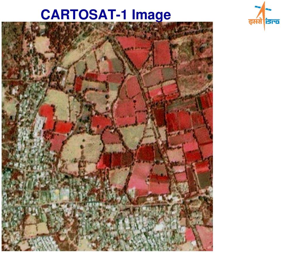
10 LAUNCH VEHICLE SATELLITE ARYABHATA Four Decades of Indian Space Programme Applications driven programme Self reliance in building & launching satellites 2.5 m resolution, 30 Km Swath Stereo mission; +26 / -5 forward/ Aft view Revisit : 5 days Along Track Stereo viewing - first of its kind in the world INSAT-3E KALPANA INSAT-2E INSAT-3C CARTOSAT-1 INSAT-3B PSLV INSAT-3A TODAY, GSLV 2 ONE AMONG THE SIX NATIONS GSAT APPLICATIONS IRS-1C IRS-P IRS-1D IRS-P TES IRS-P IRS-P Missions

11 CARTOSAT-1 Image
12 During Floods Airborne SAR data of 24-Jul-2004 Airborne SAR data over Bihar State Darbhanga Area Kansi * * Sabhan Badhbasti * Simra* Kamrauli * Manlari * * Ganawli * Chatiriya * Jalwara Khirol Nadi DARBHANGA * Baliya * Kadaria Banauli * Rampur * * Bajrdpur Yaunga * FLOOD INUNDATION Bharaul * Baluwahi * Baghmati River Dih Rampur * * Mahnauli Panchobh* Kamalpur * Baghla * Baghia * Taralahi * Chandih * * Ballapur Ekmighat * LAHERIA SARAI Affected Embankment

13 Programmatic Response to Tsunami Multi-Tasking for Disaster Reduction Tsunami affected A& N Islands ISRO Telemedicine Network Used for locating the missing children.. Multitasking Satcom/ VSATs: Deployable terminals, Mobile WLL VSATs Space + Other IT-enabled Services Tele-education: Broadband System E-Governance Tele-Medicine: Broadband System Emergency Disaster Communication Management Support: Emergency Communication, Vulnerability, Risk & Early Warning Telemedicine Spatial Info. support, Weather info., Farmers Advisory services,.. Trinkat Island Access to: Telephone, Fax, Internet Pre-Event Post-Event

14 Katchal Island before & after Tsunami IRS-P6 AWiFS Image of 21-Dec-04 IRS-P6 AWiFS Image of 26-Dec-04

15 Locale-specific Early Warning System Cyclone Warning Dissemination System (CWDS) Inputs INSAT VHRR Imaging/ Cyclone Tracking Cyclone Warning Cyclone Warning Centre Earth Station C-Band Uplink S-Band Downlink Cyclone Formation More than 250 CWDS Installed in the Coastal Areas Focus: Track, Intensity, Landfall predictions

16 INSAT MSS Ground Terminals U/L MHz D/L MHz PILOT CARRIER U/L MHz D/L MHz U/L MHz D/L MHz MOBILE REMOTE TERMINAL 2.1 M 11 M S-BAND C-BAND HUB EQUIPMENTS HUB NETWORK MOBILE REMOTE TERMINAL PSTN / DATA / FAX Type-D terminal Briefcase terminal with solar panel on the cover, and battery back-up. Two-way voice link capability. Uplink and downlink work in S-band. Development & evaluation completed, units under field trial. Serviced by a central Hub with DAMA NMS.

17 Strengthening of Observation Network Automatic Weather Station (AWS) Developed thro Industry Partnership Large No. of AWS - replacing human observers world over Facilitate frequent/ continuous observations Data transmission via satellite to receiving station; and directly as input to numerical models Met. Sensor Data Satellite Transmitter Dedicated Team/ User Dept. Data Processing Center

18 Strengthening of Observation Network Doppler Weather Radar IMD - ISRO Doppler Weather Radar at Sriharikota Continuous monitoring of severe weather events Key parameters for atmospheric studies Urgent need to expand the Radar network to cover entire coastal areas, NE region, major cities,

19 Decision Support Centre at NRSA, Hyderabad ALERT (Advance) Info. on Disaster Disaster Forecasting Organizations (CWC, IMD, ) Other Sources (Press/ TV, Local Bodies, NGO) Satellite Data Programming and Acquisition (NRSA Earth Station / NDC) Database, Knowledge Banks Ground / Ancillary Information Data Satellite, Aerial Coarse - High Resolution Optical Microwave Acquisition of data Data Analysis Outputs ASAR/ALTM/DC etc. Flight Planning Defense clearance Data acquisition, processing and transfer to DSC Hardware & software Customized Analysis Tools Dissemination to Users VSAT, FTP, Web page, etc.

20 DMS - Infrastructure Aerospace Systems Imaging Hot spot Met/Ocean Observation Emergency communication High Resolution Imaging Laser Terrain Mapper Institutional Interfaces All weather mapping Real Time Mapping Knowledge networks Inputs Decision Support Centre (DSC) Concerns User community Scientific Inputs Rapid Mapping Vulnerability, Risk Policy / Management decision Communications Backbone Terrestrial & Satellite based (Mobile Terminals, VSAT, WLL VSATs, CWDS, S&R,..)

21 Virtual Private Network under DMS N Knowledge Institutions State Emergency Centres 5.. N VPN Decision Support Centre Nodal Agency 1
22 Conclusion The Disaster Management Support programme of ISRO is the outcome of the extensive efforts put towards optimally utilizing the capabilities of the space systems to provide critical inputs to the disaster management efforts. Prime Minister of India talking to Tsunami disaster affected people, with satellite communication antenna in the background.
Indian Diplomacy At Work
 Indian Diplomacy At Work 50 YEARS OF INDO-FRENCH SPACE CO-OPERATION BRINGING BENEFITS TO MANKIND 50 YEARS OF INDO-FRENCH SPACE CO-OPERATION Bringing Benefits to Mankind A time-tested partnership India
25 Years of Indian Remote Sensing Satellite (IRS) Series
 Series") 25 Years of Indian Remote Sensing Satellite (IRS) Series Vinay K Dadhwal Director National Remote Sensing Centre (NRSC), ISRO Hyderabad, INDIA 50 th Session of Scientific & Technical Subcommittee of COPUOS,
25 Years of Indian Remote Sensing Satellite (IRS) Series Vinay K Dadhwal Director National Remote Sensing Centre (NRSC), ISRO Hyderabad, INDIA 50 th Session of Scientific & Technical Subcommittee of COPUOS,
Indian Space Programme -Update on activities (Feb 2015)
") Indian Space Programme -Update on activities (Feb 2015) Vinay K Dadhwal India Director, National Remote Sensing Centre (NRSC), INDIAN SPACE RESEARCH ORGANISATION 52 nd Science & Technology Sub-Committee,
Indian Space Programme -Update on activities (Feb 2015) Vinay K Dadhwal India Director, National Remote Sensing Centre (NRSC), INDIAN SPACE RESEARCH ORGANISATION 52 nd Science & Technology Sub-Committee,
Current status and Future Prospects of Indian Satellite
 Current status and Future Prospects of Indian Satellite Devendra singh and Sanjiv Nair Ministry of science and Technology Department of Science and technology Technology Bhawan,New Mehrauli Road, New Delhi-110016
Near Real Time Flood Mapping & Monitoring
 Near Real Time Flood Mapping & Monitoring C.M.BHATT Disaster Management Support Division National Remote Sensing Centre (NRSC / ISRO) Hyderabad, India [email protected] 7-8 December, 2014 ISPRS PRE-SYMPOSIUM
Disaster Risk Reduction through people centered National Multi-hazard Early Warning System in the context of Maldives
 Disaster Risk Reduction through people centered National Multi-hazard Early Warning System in the context of Maldives Abdul Muhusin, Deputy Director Department of Meteorology, Maldives Fourth Technical
Telemedicine. Healing Touch Through Space. Enabling Specialty Healthcare to the Rural and Remote Population of India
 Telemedicine Healing Touch Through Space Enabling Specialty Healthcare to the Rural and Remote Population of India With an area of about 3.2 million square kilometres, India is the seventh largest country
Status Report on current and future Geostationary Indian Satellites
 Status Report on current and future Geostationary Indian Satellites By Dr. Devendra Singh Director Satellite Meteorology India Meteorological Department New Delhi-110003 SATELLITE METEOROLOGY DIVISION
How To Manage A Disaster In India
 Institutional Arrangements for Disaster Management in India Prof. N. Vinod Chandra Menon Member National Disaster Management Authority Government of India Features of an Emergency Situation Sense of urgency
Innovative E-Government Best Practices in Early Warning System for Disaster Risk Management: Bangladesh Experience
 Innovative E-Government Best Practices in Early Warning System for Disaster Risk Management: Bangladesh Experience Dilder Ahmed (Joint Secretary) Project Director ECRRP-D-1 Department of Disaster Management.
INFORMATION TECHNOLOGY FOR DISASTER MANAGEMENT Tulsi Vyas [email protected] Aneri Desai [email protected]
 Computing for Nation Development, February 23 24, 2007 Bharati Vidyapeeth University Institute of Computer Applications and Management, New Delhi. INFORMATION TECHNOLOGY FOR DISASTER MANAGEMENT Tulsi Vyas
The first successful satellite launch by the
 CHAPTER XXX SPACE PROGRAMME The first successful satellite launch by the Soviets in 1957 ushered in the space era. At initial stages, critical military applications, national prestige and enabling space
Application of Space Technology for Disaster monitoring and assessment current state in Vietnam
 Application of Space Technology for Disaster monitoring and assessment current state in Vietnam Lai Anh Khoi SPACE TECHNOLOGY INSTITUTE 8th GEOSS Asian Pacific Symposium Beijing, Sep. 09-11, 2015 Types
The National Strategy, Current Activities for Space Technology Development and Application
 14-18 November 2011, Putrajaya, Malaysia The National Strategy, Current Activities for Space Technology Development and Application Lai Anh Khoi Space Technology Institute, VAST, Vietnam Bief History Space
CHEIA Satellite Communication Center
 Opened in October 1976,, from Prahova region, Romania, is the largest teleport in Central and South-eastern Europe. Located in a unique natural environment in the country due to the mountainous relief
Istanbul Technical University-Center for Satellite Communications and Remote Sensing (ITU-CSCRS)
") Istanbul Technical University-Center for Satellite Communications and Remote Sensing (ITU-CSCRS) Istanbul Technical University, Center for Satellite Communications and Remote Sensing (ITU-CSCRS) was originally
Istanbul Technical University-Center for Satellite Communications and Remote Sensing (ITU-CSCRS) Istanbul Technical University, Center for Satellite Communications and Remote Sensing (ITU-CSCRS) was originally
Domestic Policy Framework on Adaptation to Climate Change in Water Resources: Case Study for India. Working Together to Respond to Climate Change
 Domestic Policy Framework on Adaptation to Climate Change in Water Resources: Case Study for India Working Together to Respond to Climate Change WATER ACCOUNTING OF INDIA S TOTAL WATER RESOURCES Unutilizable
Head 168 HONG KONG OBSERVATORY
 Controlling officer: the Director of the Hong Kong Observatory will account for expenditure under this Head. Estimate... $203.4m Establishment ceiling (notional annual mid-point salary value) representing
Satellite Basics. Benefits of Satellite
 Satellite Basics Benefits of Satellite People need access to enterprise-class, high-speed voice, video and data applications wherever they happen to be. Satellite connectivity has the power to drive communications
OUTLINES. Earth Observation Satellite Program of Vietnam and applications for disaster management
 UNESCAP ICC & HLDM Meetings, Bangkok 26 28/11/2013 Earth Observation Satellite Program of Vietnam and applications for disaster management OUTLINES 1. VNREDSat-1 (VAST*) - Optical 2. VNREDSat-1B (VAST)
China Earth Observation
 China High-resolution Earth Observation China Earth Observation System (CHEOS) and its Lastest Development The Earth Observation System and Data Center, CNSA 2014-2 Outlines 1 Introduction 2 The composition
ROLE OF REMOTE SENSING AND ITS APPLICATIONS IN DISASTER MANAGEMENT LIKE EARTHQUAKE, FLOOD AND TSUNAMIS. Rajeev 1, Tanuja 2,
 ROLE OF REMOTE SENSING AND ITS APPLICATIONS IN DISASTER MANAGEMENT LIKE EARTHQUAKE, FLOOD AND TSUNAMIS. Rajeev 1, Tanuja 2, Abstract: This study highlights the use of remote sensing technologies in disaster
INDIA S NATIONAL INITIATIVES AND EXPERIENCES RELATED TO WIND RESOURCE ASSESSMENT
 INDIA S NATIONAL INITIATIVES AND EXPERIENCES RELATED TO WIND RESOURCE ASSESSMENT Dr.S.Gomathinayagam ED/CWET & K.Boopathi Scientist & Unit Chief i/c Wind Resource Assessment Unit Centre for Wind Energy
Natural Disasters & Assessing Hazards and Risk. Natural Hazards and Natural Disasters
 Page 1 of 9 EENS 3050 Tulane University Natural Disasters Prof. Stephen A. Nelson Natural Disasters & Assessing Hazards and Risk This page last updated on 19-Aug-2014 Natural Hazards and Natural Disasters
Remote Sensing Applications in Support of Sustainable Development and Disaster Management by DLR Current Activities
 Remote Sensing Applications in Support of Sustainable Development and Disaster Management by DLR Current Activities Dr. Günter Strunz German Aerospace Center (DLR) German Remote Sensing Data Center 43rd
8. Communications Subsystem
 PM-1.1-03 Rev C 8. Communications Subsystem The GOES-NOP spacecraft communications subsystem provides requisite conditioning, transmission, reception, and routing of mission data signals and telemetry
Monitoring Soil Moisture from Space. Dr. Heather McNairn Science and Technology Branch Agriculture and Agri-Food Canada [email protected].
 Monitoring Soil Moisture from Space Dr. Heather McNairn Science and Technology Branch Agriculture and Agri-Food Canada [email protected] What is Remote Sensing? Scientists turn the raw data collected
CONTENTS. Satellite Fleet. Türksat 2A. Türksat 3A. Türksat 4A. Türksat 4B. Türksat VSAT
 www.turksat.com TURKSAT A.S. Turksat, one of the leading operators in the satellite communication business, offers flexible solutions by providing its customers with cable and wireless broadcasting, high-speed
SYLLABUS OF DIPLOMA IN DISASTER MANAGEMENT (DDM) Semester-I. Semester-II
 Semester-I. Semester-II") SYLLABUS OF DIPLOMA IN DISASTER MANAGEMENT (DDM) For Academic Session 2016-17 Duration: 1 Year Total Credit: 32 Semester-I DDM 01 Introduction to Disaster Management 6 Credit DDM 02 GIS and ICT in Disaster
SYLLABUS OF DIPLOMA IN DISASTER MANAGEMENT (DDM) For Academic Session 2016-17 Duration: 1 Year Total Credit: 32 Semester-I DDM 01 Introduction to Disaster Management 6 Credit DDM 02 GIS and ICT in Disaster
1. Introduction. FER-Zagreb, Satellite communication systems 2011/12
 1. Introduction Topics History Characteristics of satellite communications Frequencies Application 1 History Arthur C. Clark suggested in 1945. Earth coverage with 3 geostationary satellites. On 4th of
Bhuvan. Indian Earth Observation Visualization. Indian Space Research Organisation. http://bhuvan.nrsc.gov.in. Multi Resolution. Societal Applications
 Multi Resolution Bhuvan Societal Applications Indian Earth Observation Visualization http://bhuvan.nrsc.gov.in 3D Geographic Models Seamless Fly Through Indian Space Research Organisation Thematic Vectors
Communications Systems Used in the USA TARNS. Chris Hill, Meteorologist in Charge (ret) National Weather Service Seattle, Washington, USA
 National Weather Service Seattle, Washington, USA") Communications Systems Used in the USA TARNS Chris Hill, Meteorologist in Charge (ret) National Weather Service Seattle, Washington, USA Washington Faces Many Non-Weather Hazards Earthquakes Tsunamis Terrorism
Communications Systems Used in the USA TARNS Chris Hill, Meteorologist in Charge (ret) National Weather Service Seattle, Washington, USA Washington Faces Many Non-Weather Hazards Earthquakes Tsunamis Terrorism
Natural Disaster Impact on Business and Communities in Taiwan. Dr. Chung-Sheng Lee. NCDR Chinese Taipei
 Natural Disaster Impact on Business and Communities in Taiwan Dr. Chung-Sheng Lee NCDR Chinese Taipei 1 Brief Introduction of NCDR 2 Organizational Chart of NCDR NDPPC: National Disaster Preparation and
Satellite Communication for Disaster Management, Recent Trends
 Satellite Communication for Disaster Management, Recent Trends Ashok Bharti Country Head, India www.inmarsat.com [email protected] Contents Why mobile satellite communications The technology Disaster
 www.turksat.com TURKSAT A.S. Turksat, one of the leading operators in the satellite communication business, offers flexible solutions by providing its customers with cable and wireless broadcasting,
Satellite Based Solutions for Disaster Recovery and Prevention
 Satellite Based Solutions for Disaster Recovery and Prevention ITU/ESCAP Regional Workshop on Disaster Communications 12 to 15 December 2006 Bangkok, Thailand Koh Eui-Kon, Ph. D President The Asia-Pacific
El Nino in the OC. Orange County Sheriff s Department Emergency Management Division
 El Nino in the OC Orange County Sheriff s Department Emergency Management Division The mission of the Orange County Sheriff s Department s Emergency Management Division is to promote, facilitate, and support
Development of an Integrated Data Product for Hawaii Climate
 Development of an Integrated Data Product for Hawaii Climate Jan Hafner, Shang-Ping Xie (PI)(IPRC/SOEST U. of Hawaii) Yi-Leng Chen (Co-I) (Meteorology Dept. Univ. of Hawaii) contribution Georgette Holmes
How can we defend ourselves from the hazard of Nature in the modern society?
 How can we defend ourselves from the hazard of Nature in the modern society?, University of Bologna President of the EGU Division of Natural Hazards Email: [email protected] [email protected] GIFT 2013 Natural
Analysis of the US Government and Military Commercial Satellite Market Turbulent Government Contracts Impact Growth
 Analysis of the US Government and Military Commercial Satellite Market Turbulent Government Contracts Impact Growth November 2014 Contents Section Slide Number Executive Summary 4 Market Overview 8 Total
Integrated Systems since 1990. Company Profile. BKC WeatherSys Pvt. Ltd. New Delhi, India
 Company Profile BKC WeatherSys Pvt. Ltd. New Delhi, India Corporate Office: 32/33, Kusal Bazar, Nehru Place, New Delhi, India Project Office: H-135, Sector 63, Noida, Uttar Pradesh, India www.weathersysbkc.com
This booklet has been prepared with the support under the GoI-UNDP Disaster Risk Reduction Programme (2009-2012)
") b Strengthening Disaster Management in India Strengthening Disaster Management in India c This booklet has been prepared with the support under the GoI-UNDP Disaster Risk Reduction Programme (2009-2012)
b Strengthening Disaster Management in India Strengthening Disaster Management in India c This booklet has been prepared with the support under the GoI-UNDP Disaster Risk Reduction Programme (2009-2012)
Joint Polar Satellite System (JPSS)
") Joint Polar Satellite System (JPSS) John Furgerson, User Liaison Joint Polar Satellite System National Environmental Satellite, Data, and Information Service National Oceanic and Atmospheric Administration
Joint Polar Satellite System (JPSS) John Furgerson, User Liaison Joint Polar Satellite System National Environmental Satellite, Data, and Information Service National Oceanic and Atmospheric Administration
Satellite Communication Systems. mgr inż. Krzysztof Włostowski Instytut Telekomunikacji PW [email protected]
 Satellite Communication Systems mgr inż. Krzysztof Włostowski Instytut Telekomunikacji PW [email protected] Satellite Communication Satellite Communication combines the missile and microwave technologies
Position Paper on Interference in C-band by Terrestrial Wireless Applications to Satellite Applications
 Position Paper on Interference in C-band by Terrestrial Wireless Applications to Satellite Applications Adopted by International Associations of the Satellite Communications Industry Position Statement:
SATELLITE COMMUNICATION
 SATELLITE COMMUNICATION By Gaurish Kumar Tripathi. 1.0 INTRODUCTION: The use of satellite in communication system is very much a fact of everyday in life. This is evidence by the many homes, which are
Preliminary advances in Climate Risk Management in China Meteorological Administration
 Preliminary advances in Climate Risk Management in China Meteorological Administration Gao Ge Guayaquil,Ecuador, Oct.2011 Contents China Framework of Climate Service Experience in Climate/disaster risk
HYLAS 1 Programme Overview
 HYLAS 1 Programme Overview David Bestwick October 2011 AGENDA 1. The HYLAS 1 System 2. Products 3. Application Areas of Interest THE HYLAS 1 SYSTEM The HYLAS 1 System Architecture HYLAS 1 Coverage A single
WELCOMES ALL THE ATTENDEES WATER UTILISATION, MEASUREMENT AND METHODOLOGIES
 SUTRON india WELCOMES ALL THE ATTENDEES WATER UTILISATION, MEASUREMENT AND ABOUT SUTRON USA Strong Corporation was founded in 1975 Sutron Operates in : Hydrological Meteorological Oceanic Aviation Real-Time
Active and Passive Microwave Remote Sensing
 Active and Passive Microwave Remote Sensing Passive remote sensing system record EMR that was reflected (e.g., blue, green, red, and near IR) or emitted (e.g., thermal IR) from the surface of the Earth.
Certified First medical responders. Indian Red Cross Society (NHQ)
") Certified First medical responders Indian Red Cross Society (NHQ) Introduction In past years, there have been many initiatives across India for the development and training of volunteers. Indian Red Cross
Certified First medical responders Indian Red Cross Society (NHQ) Introduction In past years, there have been many initiatives across India for the development and training of volunteers. Indian Red Cross
Chapter Contents Page No
 Chapter Contents Page No Preface Acknowledgement 1 Basics of Remote Sensing 1 1.1. Introduction 1 1.2. Definition of Remote Sensing 1 1.3. Principles of Remote Sensing 1 1.4. Various Stages in Remote Sensing
Introduction to Inmarsat and the Global Xpress Ka Band System
 Introduction to Inmarsat and the Global Xpress Ka Band System Presentation for Caribbean ICT Roadshow Trinidad and Tobago September February, 2010 17, 2010 www.inmarsat.com www.inmarsat.com Agenda Brief
Hazard Detection, Monitoring, Modeling, Assessment and Warning in the Asia Pacific Region
 Chengdu Forum on UN-GGIM Global Map for Sustainable Development: Development and Applications in Urban Hazard Mapping Chengdu, Sichuan Province, China 15-17 Oct 2013 Hazard Detection, Monitoring, Modeling,
Utilizing satellite-based information for disaster risk assessment- why and how?
 Utilizing satellite-based information for disaster risk assessment- why and how? Peeranan Towashiraporn ADPC Session 1, UN International Conference on Space-based Technologies for Disaster Management September
TopoBathy Database Mozambique
 TopoBathy Database Mozambique Andrew Hoggarth, (Canada), Gordon Johnston (UK) Charles de Jongh and peter Schwarzberg (Netherlands) Montevideo Uruguay, 28 th November 2012 Fredericton Canada Heeswijk The
Ensuring the Preparedness of Users: NOAA Satellites GOES R, JPSS Laura K. Furgione
 Ensuring the Preparedness of Users: NOAA Satellites GOES R, JPSS Laura K. Furgione U.S. Permanent Representative with the WMO Deputy Director, NOAA s s National Weather Service WMO Executive Council 65
Endless Seas. We re there with you.
 MARINECOMMS Endless Seas. We re there with you. Thuraya MarineComms provides merchant shipping, fishing, government, Navy, Coast Guard and leisure users with competitively priced, robust and reliable
Web Edition: PROVISIONAL POPULATION TOTALS. Chapter 5. Census of India 2001 Series 1, India, Paper 1 of 2001. Chapter 5
 Web Edition: PROVISIONAL POPULATION TOTALS Chapter 5 Census of India 2001 Series 1, India, Paper 1 of 2001 Chapter 5 Density of Population 1 D e n s i t y o f P o p u l a t i o n One of the important indices
Natural Hazards 1.1. Natural Hazards. Objective: Natural Hazards in Western Australia Are we at risk? Page 1. Natural Hazards Years 5-7
 Natural Hazards 1.1 Engage Natural Hazards To introduce students to the natural hazards which occur in Western Australia and their risk. Western Australia experiences a range of natural hazards each year,
The Critical Role of Broadcasting in Emergencies
 The Critical Role of Broadcasting in Emergencies ITU-R WP 6A Workshop on Emergency Broadcasting Geneva, Switzerland 21 November, 2013 Craig K. Tanner Consultant, CBS Broadcasting, Inc. 1 There are some
Coastal Areas emergency alert system FAQs
 Coastal Areas emergency alert system FAQs What is the Stinger? The Stinger Mobile Alert System was developed by a local business in partnership with Hastings Civil Defence and GNS science for use in the
Government of India Earth System Science Organization Ministry of Earth Sciences India Meteorological Department
 Government of India Earth System Science Organization Ministry of Earth Sciences India Meteorological Department Press Release Dated: 1 October, 2015 Subject: Current status of southwest monsoon 2015 and
16 th IOCCG Committee annual meeting. Plymouth, UK 15 17 February 2011. mission: Present status and near future
 16 th IOCCG Committee annual meeting Plymouth, UK 15 17 February 2011 The Meteor 3M Mt satellite mission: Present status and near future plans MISSION AIMS Satellites of the series METEOR M M are purposed
Satellite: Making Technology Work
 Satellite: Making Technology Work Satellite Industry Association: Who We Are We are the world s leading satellite companies: Satellite operators and service providers Satellite spacecraft manufacturers
ALL INDIA WEATHER SUMMARY AND FORECAST BULLETIN
 Saturday 04 July 2015 ALL INDIA WEATHER SUMMARY AND FORECAST BULLETIN NIGHT Monsoon Watch The southwest monsoon has been normal over Arunachal Pradesh, Assam & Meghalaya, West Bengal & Sikkim, Odisha,
Climate Change Impacts in the Asia/Pacific Region
 Climate Change Impacts in the Asia/Pacific Region Global CC threat CC in the A/P region The Stern Review and IPCC 4 th Assessment Report both state that climate change will have adverse impact on people
The benefits of satellite telecom systems for civil protection
 The benefits of satellite telecom systems for civil protection Pascale SOURISSE President 15-17 avenue de Ségur 75007 Paris, France www.eurospace.org T+33-1-44420070 F+33-1-44420079 1 The benefits of satellite
Monitoring a Changing Environment with Synthetic Aperture Radar. Alaska Satellite Facility National Park Service Don Atwood
 Monitoring a Changing Environment with Synthetic Aperture Radar Don Atwood Alaska Satellite Facility 1 Entering the SAR Age 2 SAR Satellites RADARSAT-1 Launched 1995 by CSA 5.6 cm (C-Band) HH Polarization
Eastern Caribbean Open-Source Geospatial Data Sharing and Management Workshop
 Eastern Caribbean Open-Source Geospatial Data Sharing and Management Workshop Data Collection and Management in the Caribbean Spice Island Resort, St. George s, Grenada October 6 7, 2011 Presented by:
SARAL ACCESS TO OFF-LINE DATA
 SARAL AltiKa introduction Plot of the SARAL/AltiKa ground track over Africa (Credits: Google). S ARAL/AltiKa is a new mission in cooperation between CNES and ISRO (Indian Space Research Organization),
German Earth Observation Systems and Programs Capacities for nation building
 German Earth Observation Systems and Programs Capacities for nation building German Aerospace Center, DLR, Earth Observation Center, EOC German Remote Sensing Data Center, DFD Gunter Schreier Deputy Director
Active Fire Monitoring: Product Guide
 Active Fire Monitoring: Product Guide Doc.No. Issue : : EUM/TSS/MAN/15/801989 v1c EUMETSAT Eumetsat-Allee 1, D-64295 Darmstadt, Germany Tel: +49 6151 807-7 Fax: +49 6151 807 555 Date : 14 April 2015 http://www.eumetsat.int
Geospatial Software Solutions for the Environment and Natural Resources
 Geospatial Software Solutions for the Environment and Natural Resources Manage and Preserve the Environment and its Natural Resources Our environment and the natural resources it provides play a growing
Towards a UNITAR office in Bergen, Norway
 Towards a UNITAR office in Bergen, Norway Einar Bjorgo, UNITAR/UNOSAT Bergen, 22 October 2009 2 What is UNITAR? United Nations Institute for Training and Research Mission: To deliver innovative training
Resolution XII.13. Wetlands and disaster risk reduction
 12 th Meeting of the Conference of the Parties to the Convention on Wetlands (Ramsar, Iran, 1971) Punta del Este, Uruguay, 1-9 June 2015 Resolution XII.13 Wetlands and disaster risk reduction 1. RECALLING
Institute for Risk and Disaster Reduction University College London
 Institute for Risk and Disaster Reduction University College London Wilkins Building South Wing, UCL, Gower Street London, England, WC1E 6BT www.ucl.ac.uk/rdr Outline Reducing the impact of disasters globally
Basic Climatological Station Metadata Current status. Metadata compiled: 30 JAN 2008. Synoptic Network, Reference Climate Stations
 Station: CAPE OTWAY LIGHTHOUSE Bureau of Meteorology station number: Bureau of Meteorology district name: West Coast State: VIC World Meteorological Organization number: Identification: YCTY Basic Climatological
VSAT TECHNOLOGY & NIC VSAT NETWORK. Gyan Ranjan Nanda Scientist - D E-mail- [email protected]. SATCOM Group National Informatics Centre New Delhi
 VSAT TECHNOLOGY & NIC VSAT NETWORK Gyan Ranjan Nanda Scientist - D E-mail- [email protected] SATCOM Group National Informatics Centre New Delhi VSAT & VSAT NETWORK VSAT (Very Small Aperture Terminal): A small
WEATHER INSURANCE DERIVATIVES TO PROTECT RURAL LIVELIHOODS
 WEATHER INSURANCE DERIVATIVES TO PROTECT RURAL LIVELIHOODS International Workshop on Agrometeorological Risk Management New Delhi, India 26 October 2006 Ulrich Hess Chief of Business Risk Planning, WFP
Japan Meteorological Business Support Center (JMBSC)
") Japan Meteorological Business Support Center (JMBSC) The Japan Meteorological Business Support Center (JMBSC) is a general incorporated foundation* inaugurated in 1994, in accordance with the Meteorological
Japan Meteorological Business Support Center (JMBSC) The Japan Meteorological Business Support Center (JMBSC) is a general incorporated foundation* inaugurated in 1994, in accordance with the Meteorological
Implementing Marine SDI Through Capacity Building
 Implementing Marine SDI Through Capacity Building A TopoBathy Database for Mozambique NIOHC Colombo, 20 th 23 rd March 2012 Fredericton Canada Heeswijk The Netherlands Washington DC United States Adelaide
ABSTRACT INTRODUCTION PURPOSE
 EVALUATION OF TSUNAMI DISASTER BY THE 2011 OFF THE PACIFIC COAST OF TOHOKU EARTHQUAKE IN JAPAN BY USING TIME SERIES SATELLITE IMAGES WITH MULTI RESOLUTION Hideki Hashiba Associate Professor Department
SATELLITE OCEANOGRAPHY IN THE AZORES: PAST, PRESENT AND FUTURE
 SATELLITE OCEANOGRAPHY IN THE AZORES: PAST, PRESENT AND FUTURE Oceanography Section / DOP University of the Azores Ana Martins Email: [email protected] Azores (NE Atlantic) - very exposed to harsh environments
Environmental Data Services for Delaware:
 Environmental Data Services for Delaware: Serving Emergency Responders, Planners, and Researchers Network Delaware Day November 6, 2013 Overview Operational Data Services More than just research DEOS and
Monitoring and Early Management of Emergences: New Instruments
 Monitoring and Early Management of Emergences: New Instruments Daniele Caviglia, DITEN - University of Genoa Domenico Sguerso, DICCA - University of Genoa Bianca Federici, DICCA - University of Genoa Andrea
P. G. DIPLOMA IN DISASTER RELIEF & REHABILITATION
 P. G. DIPLOMA IN DISASTER RELIEF & REHABILITATION ORDINANCES TITLE: The title of the course shall be P. G. Diploma in Disaster Relief & Rehabilitation OBJECTIVE: The aim of this course is to impart knowledge
Earth remote sensing systems of middle and low resolution
 Earth remote sensing systems of middle and low resolution Serial on-line remote sensing satellites delivering data available on the world market V.I. Gershenzon (ScanEx R&D Center) In 1980, graduated from
PAN-AFRICAN E-NETWORK
 PAN-AFRICAN E-NETWORK A India and PAN African countries Initiative A brief summary 26 SEP 2005 V. PONRAJ Director (Technology Interface) President s Office Rashtrapati Bhavan New Delhi 110005 [email protected]
DRAFT TSUNAMI WARNING INFORMATION DISSEMINATION PROTOCOL FOR TRINIDAD AND TOBAGO (CDEMA PARTICIPATING STATE)
") DRAFT TSUNAMI WARNING INFORMATION DISSEMINATION PROTOCOL FOR TRINIDAD AND TOBAGO (CDEMA PARTICIPATING STATE) ODPM 6/3/2011 CONTENTS 1. Acronyms 2. Standard operating procedures A: (SOP A): 3. Standard
DRAFT TSUNAMI WARNING INFORMATION DISSEMINATION PROTOCOL FOR TRINIDAD AND TOBAGO (CDEMA PARTICIPATING STATE) ODPM 6/3/2011 CONTENTS 1. Acronyms 2. Standard operating procedures A: (SOP A): 3. Standard
Application of Google Earth for flood disaster monitoring in 3D-GIS
 Disaster Management and Human Health Risk II 271 Application of Google Earth for flood disaster monitoring in 3D-GIS M. Mori & Y. L. Chan Department of Information and Computer Science, Kinki University,
CRS 610 Ventura County Flood Warning System Website
 CRS 610 Ventura County Flood Warning System Website Purpose This document gives instructions and a description of the information available via the Ventura County Watershed Protection District s (VCWPD)
The RapidEye optical satellite family for high resolution imagery
 'Photogrammetric Week 01' D. Fritsch & R. Spiller, Eds. Wichmann Verlag, Heidelberg 2001. Scherer, Krischke 139 The RapidEye optical satellite family for high resolution imagery STEFAN SCHERER and MANFRED