PREPARATION OF BASE MAPS FOR MASTER PLANS
|
|
|
- Calvin Carr
- 9 years ago
- Views:
Transcription
1 Bangalore Metropolitan Region Developm ent Authority PREPARATION OF BASE MAPS FOR MASTER PLANS A case study of Bangalore Metropolitan Region Shantappa B. Honnur Additional Director of Town and Country Planning, BMRDA and Director of Town and Country Planning, Bangalore

2 Introduction to BMR Extension of KTCP Act,1961 Preparation of Base map Scope of Work Approach and Methodology Stages of Map preparation Preparation of Master Plan and case studies Latest trends-geospatial technologies for effective urban planning Conclusions

3 District Districts Taluks

4 Contd.. ULB s, UDA s and PA s in BMR NUMBER OF ULB s: 11 One Corporation 3 CMC s :Ramnagar, Channapattana, D.Ballapur 7 TMC s : Magadi, Kanakapur, Vijayapur,Devanhalli, Anekal, Hoskote, Nelamanagal 284 Gram Panchayats covering 2551 villages NUMBER OF UDA s - TWO NUMBER OF PA s - SIX

5 Contd.. PLANNING FOR BANGALORE METROPOLITAN REGION Areas within BMR Area in Sq. Kms. 1. BDA BMICAPA RCUDA Anekal LPA Nelamangala LPA Magadi LPA Hoskote LPA Kanakapura LPA BIAAPA APZ-I (excluding RCUDA & BMICAPA) 11. All IZ s in BMR TOTAL BMR
 11. All IZ s in BMR 2455.")
6 EXTENSION OF KTCP ACT TO AREA PLANNING ZONES

7 WHY INTERIM MASTER PLAN? There were no base maps for the Local Planning Areas. In view of the increased intensity of development in the LPA s, Master Plans are essential to plan, growth. guide and regulate the The BMRDA initiated the preparation of Interim Master Plans for five Local Planning Areas viz; Nelamangala, Magadi, Kanakapura, Anekal, and Hoskote in June 2006 to guide and regulate the developments. IMP-2021 was prepared through BMRDA using LISS IV with 5.8 resolution and the base map was prepared without incorporating the approved lay outs and some existing developments.

8 Anekal Local Planning Area - Rolta Magadi Local Planning Area - IN-RIMT Kanakapur Local Planning Area - Pixel Biappa Local Planning Area - Rolta Nelamangala Local Planning Area- Rolta Hoskote Local Planning Area - Pixel

9 Preparation of digital Base Maps for 5 (Anekal, Magadi, Kanakapur, Biappa & Nelamangala) Local Planning Areas (LPA) using high resolution Satellite Data (0.6 mts of Quick Bird ) at scale 1: Generation of Cadastral GIS database for each LPA by geo-referencing the revenue and Superimposing on base map. Preparation of Existing Land use maps for each LPA in the satellite images by interpretation technique and validate by field survey. Generation of Base maps and Land Use map by incorporating approved layouts plans and change of land use for the 5 LPAs.

10 Specification for base maps Feature extraction: all natural and man-made features visible in the satellite image shall be captured (digitised) as per the list of layer Each feature shall be laid on its respective layers Annotation of features: Local areas, extensions, all roads, All public offices, All educational institutions, All large hospitals, All parks and play grounds, Major places of worship, Community facilities, Major industries, prominent commercial establishments should be annotated. Ground validation by field surveys: Validation to confirm the exiting land use and also the buildings names of the roads and

11 Methodology BASE MAP BASE MAP Ortho rectified Quick bird Satellite Imagery Digitisation of details of man made and natural features, visible in the satellite imagery Quick Bird Satellite Imagery from NRSA, Hyderabad. Overlay of Cadastral Maps, Village & survey boundary Quality Check and Quality Assurance Finalisation of roads with classification and ROW PRESENT LANDUSE Present Land use - using Satellite imagery Extraction of Features Creation of Layers Ground Verification/Surveys and land use updates Preparation of final land uses with attributes Quality Check and Quality Assurance

12 High Resolution (0.6m) Quick Bird Satellite Imagery. Total station survey for Anekal, BIAPPA and Neelamangla(19.47 Sq.km) Cadastral Maps Layout Plans Interim Master Plans SOI Toposheets(Option) Historical Monument Details
 Cadastral Maps Layout Plans Interim Master Plans")
13 Identification OF GCP points on satellite for field survey

14 Identification of location of GCPs and DGPS observation in field

15 Registration and Ortho Rectification of Satellite Image using DGPS surved points.. Accuracy to be maintained within 3pixel.

16 Feature extraction for generation of digital base maps on Satellite Image

17 Cadastral Map Registration on Orthorectified Satellite Image.

18 Capture Cadastral Features on Geo-referenced Satellite Image.

19 Geo-reference Layout Plan using Ortho-rectified satellite image Capture Circulation Pattern, Parks and CA from registered Layout Plan

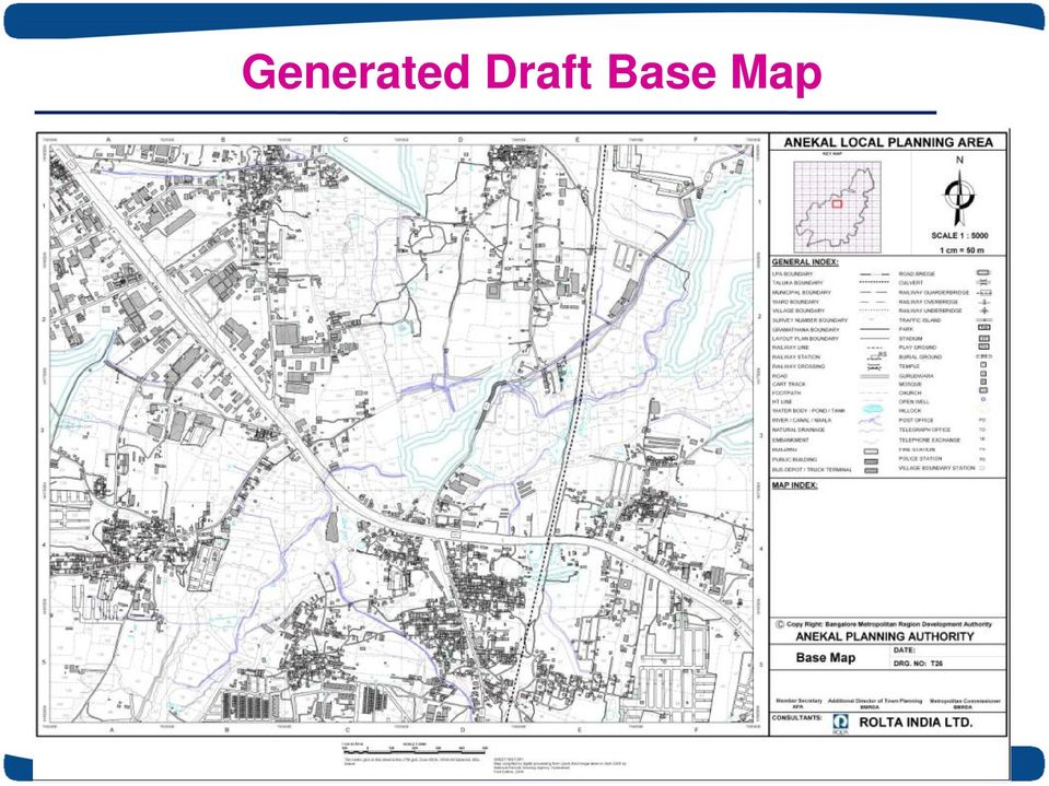
20 Generated Draft Base Map
21 Capture Land use Features on Satellite Image
22 Generate Land use Survey Plots with Satellite Generate Land use Survey Plots with Satellite Image at Background
23 Survey mark the Building name and Land use
24 Incorporate survey marked Building name and Landuse.
25 Generating Final Land use Plots
26 The Process: Preparation of Master Plan 2031 Preparation of scientific base maps was taken up by BMRDA during Used Q.B. satellite image (.60 m. Resolution) as the source data for extracting existing developments revenue data was incorporated All the approved layouts, change of land uses, major roads were incorporated as per notification etc., finalized the maps with the technical support of Karnataka Remote sensing agency (KSRSAC) during April 2012 existing land use finalized during July 2012.
27 NELAMANGALA PLANNING AREA APPROVED LAYOUTS - NELAMANGALA IMP MP
28 IMP-MP CHANGES: KANAKAPURA Kanakapura Master Plan 2031 IMP MP Incorporation of existing developments Incorporation of existing developments Kanakapura Planning Authority SKY GROUP
29 GEOGRAPHICAL PROFILE Located at a distance of 35 km from Bangalore Situated at 77 42' 8.181" E and 12 45' " N Total geographical area Sq km District - Bangalore Urban Taluk - Anekal No of Hoblis - 4 Total no of settlements in the LPA Anekal Planning Authority
30 GROWTH POTENTIAL IN THE LPA 1 Continuity of conurbation with BDA SARJAPURA 2 Huge housing projects by KHB ELECTRONI C CITY BOMMASANDRA 3 4 Existing Bommasandra KIADB industrial area IT SEZ in Sarjapura (Infosys 400 Acres, Wipro 250 Acres) ATTIBELE World class granite industries in Jigani and KIADB 5 industrial areas JIGANI HOSUR 6 Healthcare hub in Chandapura 7 Educational facilities in the region ANEKAL 8 Industrial influence of the neighboring industries in Hosur (Tamil Nadu) 9 Bangalore Chennai Industrial Corridor
31 Anekal Planning Authority BASEMAP OF ANEKAL
32 PREPARATION OF EXISTING LAND USE MAP
33 Approved Layout INTERIM MASTER PLAN JIGANI PLANNING DISTRICT MASTER PLAN PROPOSAL Approved Layout is not incorporated Anekal Planning Authority Layouts, CA, Parks & Roads are incorporated
34 JIGANI PLANNING DISTRICT INTERIM MASTER PLAN MASTER PLAN PROPOSAL Anekal Planning Authority K.H.B. Approved Layout has been considered
35 GIS for various uses GPS Control Survey Digitization Thematic Mapping from Satellite Imagery Digital Terrain Models Web GIS GIS Application tools
36 CONCEPT OF GIS READY BASE MAP Electric Network Transportation Social Data Lakes and Tanks Water and Sewerage Industries Infrastructure Irrigation Buildings GIS MAPS FACILITATES FOR ANALYSIS Heritage OF DIFFERENT THEMES & USED FOR PLANNING OF VARIOUS ACTIVITIES.

37
Enterprise Geographic Information System for Bangalore City
 Enterprise Geographic Information System for Bangalore City RaghunathM 1 and Shankar B 2 Abstract-Geographical Information System (GIS) is an effective tool for planning and management of a metropolitan
DRAFT MASTER PLAN - 2015
 DRAFT MASTER PLAN - 2015 An Integrated Planning Approach... Amenities Housing Transport Solid Waste Land Use Industry Slums Logistics Agriculture Natural Areas Hi-Tech Population Heritage Water Small Industry...
Updation of Cadastral Maps Using High Resolution Remotely Sensed Data
 International Journal of Engineering and Advanced Technology (IJEAT) Updation of Cadastral Maps Using High Resolution Remotely Sensed Data V. V.Govind Kumar, K. Venkata Reddy, Deva Pratap Abstract:A cadastral
A GIS helps you answer questions and solve problems by looking at your data in a way that is quickly understood and easily shared.
 A Geographic Information System (GIS) integrates hardware, software, and data for capturing, managing, analyzing, and displaying all forms of geographically referenced information. GIS allows us to view,
Assessing the implementation of Rawalpindi s Guided Development Plan through GIS and Remote Sensing Muhammad Adeel
 Assessing the implementation of Rawalpindi s Guided Development Plan through GIS and Remote Sensing Muhammad Adeel (Lecturer Muhammad Adeel, Institute of Geographical Information Systems, NUST, H-12 Islamabad,
Remote Sensing and GIS Application In Change Detection Study In Urban Zone Using Multi Temporal Satellite
 Remote Sensing and GIS Application In Change Detection Study In Urban Zone Using Multi Temporal Satellite R.Manonmani, G.Mary Divya Suganya Institute of Remote Sensing, Anna University, Chennai 600 025
Development and Deployment of GIS Based Spatial Decision Support System. for. Greater NOIDA Industrial Development Authority
 Development and Deployment of GIS Based Spatial Decision Support System for Greater NOIDA Industrial Development Authority About Development Authority in India Development Authorities in India play a very
Gram Panchayat & Ward Boundary Delineation and Assets mapping
 Gram Panchayat & Ward Boundary Delineation and Assets mapping For Rural Development Department & State Election Commission, Govt. of Maharashtra MAHARASHTRA REMOTE SENSING APPLICATIONS CENTRE Autonomous
Development of Rural Drinking Water Security Plan A Case Study from Raipur Block, Bhilwara District, Rajasthan
 Development of Rural Drinking Water Security Plan A Case Study from Raipur Block, Bhilwara District, Rajasthan Dr. B. K. Bhadra Scientist/Engr. SF Regional Remote Sensing Centre (RRSC-W) NRSC/ISRO, Dept.
Image Registration. Using Quantum GIS
 Using Quantum GIS Tutorial ID: IGET_GIS_004 This tutorial has been developed by BVIEER as part of the IGET web portal intended to provide easy access to geospatial education. This tutorial is released
A Sub-Scheme under AMRUT
 1 A Sub-Scheme under AMRUT TITLE Sub-Mission under AMRUT - Formulation of GIS-Based Master Plans for AMRUT Cities 1. OBJECTIVES The objective is to develop common digital geo-referenced base maps and land
NATIONAL REMOTE SENSNG CENTRE (ISRO, Department of Space, Govt. of India) nrsc
 nrsc") nrsc NATIONAL REMOTE SENSNG CENTRE (ISRO, Department of Space, Govt. of India) Balanagar, Hyderabad 500 037 Expression of Interest (EOI) for Engaging reputed geospatial industry on preparation of Large
nrsc NATIONAL REMOTE SENSNG CENTRE (ISRO, Department of Space, Govt. of India) Balanagar, Hyderabad 500 037 Expression of Interest (EOI) for Engaging reputed geospatial industry on preparation of Large
Introduction to GIS (Basics, Data, Analysis) & Case Studies. 13 th May 2004. Content. What is GIS?
 & Case Studies. 13 th May 2004. Content. What is GIS?") Introduction to GIS (Basics, Data, Analysis) & Case Studies 13 th May 2004 Content Introduction to GIS Data concepts Data input Analysis Applications selected examples What is GIS? Geographic Information
Introduction to GIS (Basics, Data, Analysis) & Case Studies 13 th May 2004 Content Introduction to GIS Data concepts Data input Analysis Applications selected examples What is GIS? Geographic Information
Presentation On Cadastral Survey Projects
 Presentation On Cadastral Survey Projects at Ghana Geospatial Forum, Hotel Movenpick Accra 04 Mar 2015 Agenda Introduction About the Company About the NLRMP Project Scope Cadastral Survey (Ground Method)
र य स द र स व दन क / NATIONAL REMOTE SENSING CENTRE
 भ रत सरक र / GOVERNMENT OF INDIA अ तर वभ ग / DEPARTMENT OF SPACE र य स द र स व दन क / NATIONAL REMOTE SENSING CENTRE ब ल नगर, ह दर ब द / BALANAGAR, HYDERABAD-500037 एनआरएसस /य/ईओआई/2/NRSC/PUR/EOI/2/PT-148
Format for scrutinising the Hill Station Building Applications ( Current File No. 24911/2001-HSBA) The application shall be accompanied by
 The application shall be accompanied by") Format for scrutinising the Hill Station Building Applications ( Current File No. 24911/2001-HSBA) 1 2 3 4 5 I. Tamil Nadu Districts Municipalities (Hill Stations) Building Rules 1993. Rules Required Available
Format for scrutinising the Hill Station Building Applications ( Current File No. 24911/2001-HSBA) 1 2 3 4 5 I. Tamil Nadu Districts Municipalities (Hill Stations) Building Rules 1993. Rules Required Available
GOVERNMENT OF ASSAM OFFICE OF THE DIRECTOR, TOWN AND COUNTRY PLANNING, ASSAM DISPUR : GUWAHATI 781036.
 RFP for preparation of GIS based maps :: January 2016 :: Directorate of Town and Country Planning, Assam GOVERNMENT OF ASSAM OFFICE OF THE DIRECTOR, TOWN AND COUNTRY PLANNING, ASSAM DISPUR : GUWAHATI 781036.
INDIVIDUAL COURSE DETAILS
 INDIVIDUAL COURSE DETAILS A. Name of Institution NATIONAL INSTITUTE OF TECHNICAL TEACHERS TRAINING AND RESEARCH TARAMANI CHENNAI 600 113 [An Autonomous Institute under Ministry of Human Resource Development,
DISASTER DISASTER MANAGEMENT CRISIS INFORMATICS GIS IN DIFFEERENT STAGES OF DISASTER MANAGEMENT
 APPLICATION OF GIS AND REMOTE SENSING IN DISASTER PRONE AREAS: A CASE STUDY IN COASTAL KERALA DISASTER Disaster is an unpleasant event than occurs with little or no warning which results in economic disruption,
Drakenstein has a rich historic
 Drakenstein GIS heritage management system by Janine Penfold, Drakenstein Municipality The National Heritage Resources Act 25 of 1999, Section 30 paragraph 5 states: On request, need or revision of a zoning
APPLICATION OF GOOGLE EARTH FOR THE DEVELOPMENT OF BASE MAP IN THE CASE OF GISH ABBAY SEKELA, AMHARA STATE, ETHIOPIA
 APPLICATION OF GOOGLE EARTH FOR THE DEVELOPMENT OF BASE MAP IN THE CASE OF GISH ABBAY SEKELA, AMHARA STATE, ETHIOPIA Abineh Tilahun Department of Geography and environmental studies, Adigrat University,
DETECTING LANDUSE/LANDCOVER CHANGES ALONG THE RING ROAD IN PESHAWAR CITY USING SATELLITE REMOTE SENSING AND GIS TECHNIQUES
 ------------------------------------------------------------------------------------------------------------------------------- Full length Research Paper -------------------------------------------------------------------------------------------------------------------------------
Qatar National Geospatial Infrastructure
 Qatar National Geospatial Infrastructure Since 1990 up to 2030 and beyond Mohammad Abd El-Wahab Hamouda GIS Consultant & Chairman of GIS Coordinators Group The Center for GIS Ministry of Municipality and
Understanding Raster Data
 Introduction The following document is intended to provide a basic understanding of raster data. Raster data layers (commonly referred to as grids) are the essential data layers used in all tools developed
Department of Revenue & Disaster Management. Govt. of Haryana. Expression of Interest Invited for
 Department of Revenue & Disaster Management Govt. of Haryana Expression of Interest Invited for Digitization & Updating of Cadastral Maps(Mussavis) and Complete Document Management of Old Records. Phone:
Survey and Mapping Activities in Vietnam *
 UNITED NATIONS E/CONF.100/CRP.1 ECONOMIC AND SOCIAL COUNCIL Eighteenth United Nations Regional Cartographic Conference for Asia and the Pacific Bangkok, 26-29 October 2009 Item 7(a) of the provisional
MAPPING MINNEAPOLIS URBAN TREE CANOPY. Why is Tree Canopy Important? Project Background. Mapping Minneapolis Urban Tree Canopy.
 MAPPING MINNEAPOLIS URBAN TREE CANOPY Why is Tree Canopy Important? Trees are an important component of urban environments. In addition to their aesthetic value, trees have significant economic and environmental
PRESENTATION. Improving the performance of Public Water Utilities A case study of Bangalore N.C. MUNIYAPPA, Chairman, BWSSB LOCATION MAP OF BANGALORE
 Arabian Sea Mumbai KARNATAKA Delhi Chennai Nepal Calcutta Bay of Bengal PRESENTATION Improving the performance of Public Water Utilities A case study of Bangalore By N.C. MUNIYAPPA, Chairman, BWSSB LOCATION
Information system for rural road network planning - a case study
 Information system for rural road network planning - a case study I. Prasada Rao*, B. Kangadurai*, P. K. Jain* and Dr. Neelam Jain* * Scientist, Central Road Research Institute, New Delhi [email protected]
BANGALORE ELECTRICITY SUPPLY COMPANY LIMITED
 BANGALORE ELECTRICITY SUPPLY COMPANY LIMITED List of Public Information Officers (PIO) and Asst. Public Information Officers (APIO) of BESCOM Sl. Name of the Office PIO 1 Corporate Office General Manager(Tech)
Using Google Earth for Environmental Science Research
 Using Google Earth for Environmental Science Research This document is up-to-date as of August 2013. If you have any questions or additions to this material please email [email protected]. Note: this
Analysis of Land Use/Land Cover Change in Jammu District Using Geospatial Techniques
 Analysis of Land Use/Land Cover Change in Jammu District Using Geospatial Techniques Dr. Anuradha Sharma 1, Davinder Singh 2 1 Head, Department of Geography, University of Jammu, Jammu-180006, India 2
The Courses. Covering complete breadth of GIS technology from ESRI including ArcGIS, ArcGIS Server and ArcGIS Engine.
 ESRI India: Corporate profile ESRI India A profile India s Premier GIS Company Strategic alliance between ESRI Inc. and NIIT Technologies Adjudged as India s Best GIS Solutions Company - Map India 2001
Liberia Forest Mapping. World Bank January 2012
 Liberia Forest Mapping World Bank January 2012 Scope of presentation 1. Overview (5 min) 2. Service presentation (20 min) 3. Operational scenario (10min) 4. Service Utility Review (45 min) 5. Wrap-up and
Positioning for the future: Trends in technology, big data, 2020 round of censuses and post 2015 development agenda
 Positioning for the future: Trends in technology, big data, 2020 round of censuses and post 2015 development agenda Tarak Chandra Patra, ISS Data Processing Division, National Sample Survey Office Ministry
Sharthi Laldaparsad. Statistics South Africa Executive Manager: Policy Research & Analysis. 1 August 2014, Washington DC, USA. Contents...
 Geographic Databases from population censuses to fundamental framework data for statistics to National Development Planning, Monitoring and Evaluating, South Africa Sharthi Laldaparsad Statistics South
Supervised Classification workflow in ENVI 4.8 using WorldView-2 imagery
 Supervised Classification workflow in ENVI 4.8 using WorldView-2 imagery WorldView-2 is the first commercial high-resolution satellite to provide eight spectral sensors in the visible to near-infrared
Digital data collection and registration on geographical names during field work*
 UNITED NATIONS WORKING PAPER GROUP OF EXPERTS NO. 13 ON GEOGRAPHICAL NAMES Twenty-sixth session Vienna, 2-6 May 2011 Item 20 of the Provisional Agenda Other toponymic issues Digital data collection and
1. Introduction. V.S.S. Kiran 1, Y.K. Srivastava 2 and M. Jagannadha Rao 3
 Cloud Publications International Journal of Advanced Remote Sensing and GIS 2014, Volume 3, Issue 1, pp. 592-597, Article ID Tech-273 ISSN 2320-0243 Case Study Open Access Utilization of Resourcesat LISS
APPLICATION OF ALOS DATA FOR LAND USE CHANGE IN GREEN AREA OF BANG KA CHAO, SAMUT PRAKAN PROVINCE
 APPLICATION OF ALOS DATA FOR LAND USE CHANGE IN GREEN AREA OF BANG KA CHAO, SAMUT PRAKAN PROVINCE Chanika Sukawattanavijit, Ekkarat Pricharchon Geo-Informatics Scientist Geo-Informatics and Space Technology
GIS BASED LAND INFORMATION SYSTEM FOR MANDAL SOUM, SELENGE AIMAG OF MONGOLIA
 GIS BASED LAND INFORMATION SYSTEM FOR MANDAL SOUM, SELENGE AIMAG OF MONGOLIA B. Tuul GTZ, Land Management and Fiscal Cadastre project, Government building 12, ALAGCaC, Ulaanbaatar, Mongolia [email protected],
Site-specific management at Bowles Farming Company. UC Davis Precision Ag Workshop 7/14/2010 Cannon Michael Bowles Farming Company, Inc.
 Site-specific management at Bowles Farming Company UC Davis Precision Ag Workshop 7/14/2010 Cannon Michael Bowles Farming Company, Inc. Bowles Farming Company, Inc. Family owned and operated 150+ years
Cartosat-1 10 years and beyond
 nrsc Cartosat-1 10 years and beyond Cartosat-1 : 10 years completion in Orbit (2005-2015) 5th May 2015 National Remote Sensing Centre Indian Space Research Organisation Dept. of Space, Govt. of India Balanagar,
Urban Land Use Data for the Telecommunications Industry
 Urban Land Use Data for the Telecommunications Industry Regine Richter, Ulla Weingart & Tobias Wever GAF AG Arnulfstr. 197 D-80634 Munich & Ulrike Kähny E-Plus Mobilfunk GmbH & Co. KG E-Plus Platz D-40468
A DIACHRONIC STUDY ON THE URBAN GROWTH OF DAKAR YEAR 1988, 1998 AND 2007
 A DIACHRONIC STUDY ON THE URBAN GROWTH OF DAKAR YEAR 1988, 1998 AND 2007 Presented by DIALLO Ngagne PGD in GIS and Cartography Gis analyst in the Cadastre of Senegal Republic of Senegal Ministry of Economy
ADVANCED GEO-TECH SOLUTIONS
 Office Reg. No.: 9992 194019 Service T.No. : AGSPL 3094 PSD 001 PAN NO.: AGSPL 3094 P TAN NO. : LKNC 06091 B ADVANCED GEO-TECH SOLUTIONS ISO 9001 ; 2008 STANDARDS 1 / 643, Sector H, Jankipuram LUCKNOW
From : Başpınar & Partners Law Firm. Date : 27.06.2014. Subject : Communiqué on Spatial Planning Preparation I. INTRODUCTION
 From : Başpınar & Partners Law Firm Date : 27.06.2014 Subject : Communiqué on Spatial Planning Preparation I. INTRODUCTION Communiqué on Spatial Planning Preparation ( Communiqué ) which is prepared by
Mapping and Modelling the Impact of Land Use Planning and Management Practices on Urban and Peri-Urban Landscapes in the Greater Dublin Area
 Mapping and Modelling the Impact of Land Use Planning and Management Practices on Urban and Peri-Urban Landscapes in the Greater Dublin Area Dr. Martin Critchley Era-Maptec Ltd 36 Dame Street Dublin 2
Bhuvan. Indian Earth Observation Visualization. Indian Space Research Organisation. http://bhuvan.nrsc.gov.in. Multi Resolution. Societal Applications
 Multi Resolution Bhuvan Societal Applications Indian Earth Observation Visualization http://bhuvan.nrsc.gov.in 3D Geographic Models Seamless Fly Through Indian Space Research Organisation Thematic Vectors
Remote Sensing and Land Use Classification: Supervised vs. Unsupervised Classification Glen Busch
 Remote Sensing and Land Use Classification: Supervised vs. Unsupervised Classification Glen Busch Introduction In this time of large-scale planning and land management on public lands, managers are increasingly
DYING TREES OF DELHI DEPARTMENT OF FORESTS & WILDLIFE GOVT. OF NCT OF DELHI
 DYING TREES OF DELHI DEPARTMENT OF FORESTS & WILDLIFE GOVT. OF NCT OF DELHI DELHI At A Glance GEOGRAPHICAL AREA CAPITAL RECORDED FOREST AREA FOREST COVER : 1483 sq.km. : New Delhi : 85 Sq.Km 5.73 % of
APLS 2011. GIS Data: Classification, Potential Misuse, and Practical Limitations
 APLS 2011 GIS Data: Classification, Potential Misuse, and Practical Limitations GIS Data: Classification, Potential Misuse, and Practical Limitations Goals & Objectives Develop an easy to use geospatial
Utilizing satellite-based information for disaster risk assessment- why and how?
 Utilizing satellite-based information for disaster risk assessment- why and how? Peeranan Towashiraporn ADPC Session 1, UN International Conference on Space-based Technologies for Disaster Management September
MULTIPURPOSE USE OF ORTHOPHOTO MAPS FORMING BASIS TO DIGITAL CADASTRE DATA AND THE VISION OF THE GENERAL DIRECTORATE OF LAND REGISTRY AND CADASTRE
 MULTIPURPOSE USE OF ORTHOPHOTO MAPS FORMING BASIS TO DIGITAL CADASTRE DATA AND THE VISION OF THE GENERAL DIRECTORATE OF LAND REGISTRY AND CADASTRE E.ÖZER, H.TUNA, F.Ç.ACAR, B.ERKEK, S.BAKICI General Directorate
VCS REDD Methodology Module. Methods for monitoring forest cover changes in REDD project activities
 1 VCS REDD Methodology Module Methods for monitoring forest cover changes in REDD project activities Version 1.0 May 2009 I. SCOPE, APPLICABILITY, DATA REQUIREMENT AND OUTPUT PARAMETERS Scope This module
Accuracy Assessment of Land Use Land Cover Classification using Google Earth
 American Journal of Environmental Protection 25; 4(4): 9-98 Published online July 2, 25 (http://www.sciencepublishinggroup.com/j/ajep) doi:.648/j.ajep.2544.4 ISSN: 228-568 (Print); ISSN: 228-5699 (Online)
The Chillon Project: Aerial / Terrestrial and Indoor Integration
 The Chillon Project: Aerial / Terrestrial and Indoor Integration How can one map a whole castle efficiently in full 3D? Is it possible to have a 3D model containing both the inside and outside? The Chillon
Kingdom Of Bahrain Ministry of Works. Enterprise Asset Management System A Geocentric Approach. Presented By Hisham Y.
 Kingdom Of Bahrain Ministry of Works Enterprise Asset Management System A Geocentric Approach Presented By Hisham Y. Sater April 2012 Ministry Of Works Bahrain MOW The construction arm of the Kingdom of
Field Techniques Manual: GIS, GPS and Remote Sensing
 Field Techniques Manual: GIS, GPS and Remote Sensing Section A: Introduction Chapter 1: GIS, GPS, Remote Sensing and Fieldwork 1 GIS, GPS, Remote Sensing and Fieldwork The widespread use of computers
CHAPTER 3 GIS DATABASE
 The Study on Integrated Water Management Draft Final Report CHAPTER 3 GIS DATABASE 3.1 Introduction The project objective, concerning GIS as stated in the Inception and Interim Report, is the development
Transparent Chennai. Best Practice Documentation June 2010. Researched and Documented By. OneWorld Foundation India
 1 Transparent Chennai Best Practice Documentation June 2010 Researched and Documented By OneWorld Foundation India 2 Contents Executive Summary... 3 Background... 4 Objective... 4 Working Design... 4 Data
Database Development for Earthquake Risk Assessment. Muhammad Murad Billah Senior GIS Coordinator
 Database Development for Earthquake Risk Assessment Muhammad Murad Billah Senior GIS Coordinator CONTENTS Base Map Development Hazard Mapping - Active Fault Study - Engineering Geological Mapping - Seismic
3D Model of the City Using LiDAR and Visualization of Flood in Three-Dimension
 3D Model of the City Using LiDAR and Visualization of Flood in Three-Dimension R.Queen Suraajini, Department of Civil Engineering, College of Engineering Guindy, Anna University, India, [email protected]
Conducting a Land Use Inventory
 Chapter 3 Conducting a Land Use Inventory Included in this chapter: Determining Current Land Use Conditions Preparing a Base Map Deciding on Land Use Categories Collecting Current Land Use Data Preparing
Pima Regional Remote Sensing Program
 Pima Regional Remote Sensing Program Activity Orthophoto GIS Mapping and Analysis Implementing Agency Pima Association of Governments (Tucson, Arizona area Metropolitan Planning Organization) Summary Through
TOPOGRAPHICAL SURVEY REPORT - PART OF L.R No. 7413/11 Done on February 2015 at International Union for Conservation of Nature (IUCN) Eastern African
 Eastern African") TOPOGRAPHICAL SURVEY REPORT - PART OF L.R No. 7413/11 Done on February 2015 at International Union for Conservation of Nature (IUCN) Eastern African Regional Office 01 CHAPTER ONE Checklist Page 2 of 8
TOPOGRAPHICAL SURVEY REPORT - PART OF L.R No. 7413/11 Done on February 2015 at International Union for Conservation of Nature (IUCN) Eastern African Regional Office 01 CHAPTER ONE Checklist Page 2 of 8
Near Real Time Flood Mapping & Monitoring
 Near Real Time Flood Mapping & Monitoring C.M.BHATT Disaster Management Support Division National Remote Sensing Centre (NRSC / ISRO) Hyderabad, India [email protected] 7-8 December, 2014 ISPRS PRE-SYMPOSIUM
How to use PGS: Basic Services Provision Map App
 How to use PGS: Basic Services Provision Map App The PGS: Basic Services Provision Map App The main features of the PGP Basic Services web application includes: Navigation Tools Map Tools Main Map Links
Standard on Digital Cadastral Maps and Parcel Identifiers
 Standard on Digital Cadastral Maps and Parcel Identifiers APPROVED JULY 2003 INTERNATIONAL ASSOCIATION OF ASSESSING OFFICERS 1. Scope This standard provides recommendations on the development and maintenance
reviewed paper GIS for Urban Environmental Management Plan: Making it through the Crisis Piyali Bandyopadhyay
 reviewed paper GIS for Urban Environmental Management Plan: Making it through the Crisis Piyali Bandyopadhyay (Piyali Bandyopadhyay, Project Scientist, Central Pollution Control Board, Delhi, Flat no 437
Advanced Image Management using the Mosaic Dataset
 Esri International User Conference San Diego, California Technical Workshops July 25, 2012 Advanced Image Management using the Mosaic Dataset Vinay Viswambharan, Mike Muller Agenda ArcGIS Image Management
Name & Address of unit Activity Working/YTC
 LIST OF E-WASTE RECYCLERS AND DISMANTLERS Sl. No. Name & Address of unit Activity / 1 M/s. Ash Recyclers, No. 94, Thimmaiah Road, Bangalore - 01 2 M/s. E-Parisara Pvt Ltd, No 30-P3 Dabaspet Bangalore.
reviewed paper (Bikram Kumar Dutta, Regional Planner, Associate Manager, IL&FS, L-30,Delta II, Greater Noida, bikramdutta@hotmail.
 reviewed paper Geographic Information System for Land Acquisition Process: A Social Need for Road Infrastructure Development in India Bikram Kumar Dutta (Bikram Kumar Dutta, Regional Planner, Associate
Building & Developing the Environmental
 Building & Developing the Environmental Web Explorer for Riyadh City Authors: Engineer Yousef Bin Othman Al-Fariheedi Manager of Environmental Data Unit Environmental Management and Protection Department
GEOGRAPHIC INFORMATION SYSTEMS
 GIS GEOGRAPHIC INFORMATION SYSTEMS FOR CADASTRAL MAPPING Chapter 6 2015 Cadastral Mapping Manual 6-0 GIS - GEOGRAPHIC INFORMATION SYSTEMS What is GIS For a long time people have sketched, drawn and studied
WATER BODY EXTRACTION FROM MULTI SPECTRAL IMAGE BY SPECTRAL PATTERN ANALYSIS
 WATER BODY EXTRACTION FROM MULTI SPECTRAL IMAGE BY SPECTRAL PATTERN ANALYSIS Nguyen Dinh Duong Department of Environmental Information Study and Analysis, Institute of Geography, 18 Hoang Quoc Viet Rd.,
Extraction of Satellite Image using Particle Swarm Optimization
 Extraction of Satellite Image using Particle Swarm Optimization Er.Harish Kundra Assistant Professor & Head Rayat Institute of Engineering & IT, Railmajra, Punjab,India. Dr. V.K.Panchal Director, DTRL,DRDO,
Forest Service Southern Region Jess Clark & Kevin Megown USFS Remote Sensing Applications Center (RSAC)
") Hurricane Katrina Damage Assessment on Lands Managed by the Desoto National Forest using Multi-Temporal Landsat TM Imagery and High Resolution Aerial Photography Renee Jacokes-Mancini Forest Service Southern
Hurricane Katrina Damage Assessment on Lands Managed by the Desoto National Forest using Multi-Temporal Landsat TM Imagery and High Resolution Aerial Photography Renee Jacokes-Mancini Forest Service Southern
Coming To An Airport Near You
 Airport GIS Data & ealp Coming To An Airport Near You Kevin Shirer, AAE Project Manager Association of California Airports; September 2009 Today s Presentation & Expectations Take away Basic knowledge
GIS Solutions for FTTx Design. David Nelson, GISP
 GIS Solutions for FTTx Design David Nelson, GISP Telecom GIS Manager, Black & Veatch Agenda Intro to GIS Telecom GIS Vision GIS Strategy Project Execution Mobile Online Services Dashboards Client Deliverables
ArcGIS Data Models Practical Templates for Implementing GIS Projects
 ArcGIS Data Models Practical Templates for Implementing GIS Projects GIS Database Design According to C.J. Date (1995), database design deals with the logical representation of data in a database. The
Expert System for Solar Thermal Power Stations. Deutsches Zentrum für Luft- und Raumfahrt e.v. Institute of Technical Thermodynamics
 Expert System for Solar Thermal Power Stations Institute of Technical Thermodynamics Stuttgart, July 2001 - Expert System for Solar Thermal Power Stations 2 Solar radiation and land resources for solar
GEOGRAPHIC INFORMATION SOLUTIONS LTD. GPS Data Management & GIS Course
 GEOGRAPHIC INFORMATION SOLUTIONS LTD GPS Data Management & GIS Course 4th Floor-Outbox, Soliz House, Plot 23, Lumumba Avenue, Nakasero, Kampala Uganda. Mobile: +256 778 082 563/+256 712 593 775 Email:
Geospatial exploitation Products. GXP WebView. Powered by the GXP Platform
 Geospatial exploitation Products GXP WebView Powered by the GXP Platform Exploitation Capabilities GXP WebView Powered by the GXP Platform Detailed annotation (text, points, lines, and polygons) Distance,
THE OBJECTIVES AND FRAMEWORK FOR THE DEVELOPMENT OF FORUS
 What Forus will be CONTENTS WHY A JOINT PLAN FOR FORUS?... 3 WHAT IS A PLAN PROGRAMME?... 3 THE OBJECTIVES AND FRAMEWORK FOR THE DEVELOPMENT OF FORUS... 3 THE PLAN AREA... 4 THE LONG-TERM GOALS FOR FORUS...
Imagery. 1:50,000 Basemap Generation From Satellite. 1 Introduction. 2 Input Data
 1:50,000 Basemap Generation From Satellite Imagery Lisbeth Heuse, Product Engineer, Image Applications Dave Hawkins, Product Manager, Image Applications MacDonald Dettwiler, 3751 Shell Road, Richmond B.C.
Tools and Methods for Global Urban Analysis
 European Commission Joint Research Centre 1st Urbanization Workshop Day 2, Session 1: Tools and Methods for Global Urban Analysis Ellen Hamilton Lead Urban Specialist World Bank 1 Outline Global Agendas:
The Future of Geospatial Big Data Giovanni Marchisio, Ph.D., Director Product Development
 The Future of Geospatial Big Data Giovanni Marchisio, Ph.D., Director Product Development Nuclear Power Plant, Doel, Belgium December 10, 2011 WorldView-2 Why Geospatial Big Data? We Are the Innovators
A METHODOLOGY FOR GIS INTERFACING OF MARINE DATA
 A METHODOLOGY FOR GIS INTERFACING OF MARINE DATA Proceedings of GIS PLANET 98: International Conference and Exhibition on Geographic Information, Lisbon, Portugal, 7-11 September 1998 Vasilis Valavanis,
CIESIN Columbia University
 Conference on Climate Change and Official Statistics Oslo, Norway, 14-16 April 2008 The Role of Spatial Data Infrastructure in Integrating Climate Change Information with a Focus on Monitoring Observed
Utah State General Records Retention Schedule SCHEDULE 1 GEOSPATIAL DATA SETS
 Utah State General Records Retention Schedule SCHEDULE 1 BIOTA RECORDS (Item 1-26) These are geospatial records that depict wildlife use areas in the state of Utah as determined by wildlife biologists
Planning Guidelines for Rural Road Master Plan
 Planning Guidelines for Rural Road Master Plan (Guideline on GIS Application for Rural Road Development) Strengthening of Activities in Rural Development Engineering Center Project (RDEC-2) Local Government