Cole Easdon Consultants Limited
|
|
|
- Lillian Kelley
- 8 years ago
- Views:
Transcription
1 FLOOD RISK ASSESSMENT FOR PROPOSED EXPANSION OF WHITEHALL GARDEN CENTRE CORSHAM ROAD, LACOCK ON BEHALF OF WHITEHALL GARDEN CENTRES LTD. OCTOBER 2015 [ISSUE 2] Head Office: Unit 2 York House Edison Park Dorcan Way Swindon Wiltshire SN3 3RB Tel cec@coleeasdon.com Cole Easdon Consultants Limited Civil Engineering ~ Highways ~ Transportation ~ Flood Risk Bristol & Swindon Incorporated in UK as Cole Easdon Consultants Ltd No
![OCTOBER 2015 [ISSUE 2] Head Office: Unit 2 York House Edison Park Dorcan Way Swindon Wiltshire SN3 3RB Tel.](/docs-images/49/17971025/images/page_1.jpg "01793 619965 Email: cec@coleeasdon.")
2 FLOOD RISK ASSESSMENT PROPOSED EXPANSION OF WHITEHALL GARDEN CENTRE, CORSHAM ROAD, LACOCK Cole Easdon Consultants (CEC) DOCUMENT ISSUE RECORD Client: Project: Whitehall Garden Centre Proposed Expansion of Whitehall Garden Centre, Corsham Road, Lacock Job Number: 4694 Document Title: Issuing Office: Flood Risk Assessment Swindon Issue / Revision: Issue 1 Issue 2 Description / Status: Draft for Client Comment Formal Issue Date: September 2015 October 2015 Prepared: S. Starr BSc (Hons) S. Starr BSc (Hons) Signature: Document Check: S. Coates BA (Hons) S. Coates BA (Hons) Signature: Technical Check: R. Bowley BSc CEng MCIWEM R. Bowley BSc CEng MCIWEM Signature: Authorised: R. Bowley BSc CEng MCIWEM R. Bowley BSc CEng MCIWEM Signature: File Reference: 4694 Whitehall Garden Centre, Lacock - FRA Issue Whitehall Garden Centre, Lacock - FRA Issue 2 QMF ISSUE 5 Cole Easdon Consultants (CEC) OCTOBER 2015
 Signature: Technical Check: R. Bowley BSc CEng MCIWEM R.")
3 FLOOD RISK ASSESSMENT PROPOSED EXPANSION OF WHITEHALL GARDEN CENTRE, CORSHAM ROAD, LACOCK CONTENTS SECTION HEADING PAGE NO. 1.0 INTRODUCTION THE EXISTING SITE FLOOD RISK ISSUES PROPOSED DRAINAGE STRATEGY SUMMARY AND CONCLUSIONS 13 APPENDICES Appendix 1 CEC Figures CEC Figure 4694/500/Figure 1 CEC Figure 4694/500/Figure 2 Site Location Plan Flood Zone Map Appendix 2 Geological Records Appendix 3 Calculations Appendix 4 Report Excerpts Appendix 5 Public Sewer Records Appendix 6 CEC Plans & Drawings by Others CEC Plan 4694/500(A) Existing Site Plan Sheets 1 & 2 CEC Plan 4694/501(A) Proposed Drainage Strategy Sheets 1 & 2 Drawing No. P01(A) Proposed Site Layout Plan (by Andrew Aldridge Architects) QMF ISSUE 5 Cole Easdon Consultants (CEC) OCTOBER 2015
 Existing Site Plan Sheets 1 & 2 CEC Plan 4694/501(A) Proposed")
4 FLOOD RISK ASSESSMENT PROPOSED EXPANSION OF WHITEHALL GARDEN CENTRE, CORSHAM ROAD, LACOCK 1.0 INTRODUCTION 1.1 This Flood Risk Assessment has been prepared by Cole Easdon Consultants (CEC) on behalf of Whitehall Garden Centre in respect of a proposed expansion of Whitehall Garden Centre, Corsham Road, Lacock, Wiltshire. Refer to CEC Figure 4694/500/Figure 1 [Site Location Plan] in Appendix 1. Development Proposals 1.2 The development proposal comprises expansion of the existing garden centre to provide numerous retail units, additional external areas including an ice rink, sales yards, service areas and access roads. The existing gravel car park in the west of the site is to be formalised and resurfaced with tarmac. The existing access route from Corsham Road will be maintained. Refer to Drawing No. P01(A) [Proposed Site Layout Plan] (by Andrew Aldridge Architects) in Appendix 6. This layout forms the basis of CEC Plan 4694/501(A) [Proposed Drainage Strategy], also located in Appendix 6. Need for Study 1.3 The purpose of this assessment is to demonstrate that the proposals outlined above can be satisfactorily accommodated without worsening flood risk to the area, in accordance with the National Planning Policy Framework Document (NPPF). 1.4 Accordingly, this study has been prepared to: i) Assess flood risk to the development from fluvial sources; ii) Assess flood risk to the development from other potential sources, including ditches, sewers, groundwater and overland surface water flow; iii) Ensure that the development proposed will fully comply with the requirements of the EA's policy on the safeguarding of floodplains; iii) Provide a SUDS surface water drainage strategy for the site; and iv) identify a foul drainage strategy for the proposed development 1.5 A site topographical survey (referenced to Ordnance datum) has been provided to CEC and has been reviewed as part of this study. Refer to CEC Plan 4694/500(A) [Existing Site Plan Sheets 1 & 2] in Appendix 6. QMF ISSUE 5 Cole Easdon Consultants (CEC) 1 OCTOBER 2015
![Lacock, Wiltshire. Refer to CEC Figure 4694/500/Figure 1 [Site Location Plan] in Appendix 1. Development Proposals 1.](/docs-images/49/17971025/images/page_4.jpg "2 The development proposal comprises expansion of the existing garden centre to provide numerous retail units, additional external areas including an ice rink, sales yards, service areas and access")
5 FLOOD RISK ASSESSMENT PROPOSED EXPANSION OF WHITEHALL GARDEN CENTRE, CORSHAM ROAD, LACOCK Scope of Study 1.6 In Section 2.0, we describe the characteristics of the development site and surrounding area. In Section 3.0, we assess flood risk issues. Section 4.0 covers the proposed drainage strategy and conclusions are presented in Section The following resources have been used for this study: Flood Zone Map Environment Agency (EA); Groundwater Source Protection Zones Map - Environment Agency (EA); Geological Map - British Geological Survey (BGS); and Topographical Survey Drawing 8015 Hywel John Surveys. 1.8 The following publicly available documents have also been reviewed as part of this assessment: Wiltshire Strategic Flood Risk Assessment (Scott Wilson 2008); North Wiltshire Strategic Flood Risk Assessment Level One (Scott Wilson October 2007); Wiltshire Council Surface Water Management Plan Focused on Chippenham Trowbridge and Salisbury (URS Scott Wilson (November 2011); National Planning Policy Framework (NPPF) (March 2012); Technical Guidance to the NPPF (March 2012); Sewers for Adoption, 7 th Edition A Design and Construction Guide for Developers (SFA 7) ( March 2006); CIRIA C697 The SUDS Manual; Building Regulations 2010 Approved Document H (Drainage and Waste Disposal); and Rainfall Runoff Management for Developments (Defra). 1.9 The following abbreviations are used in this report: AOD Above Ordnance Datum; EA Environment Agency; SUDS Sustainable Urban Drainage Systems; HA Highway Authority; SAB SUDS Adopting Body; FZM Flood Zone Map prepared by the Environment Agency; NPPF National Planning Policy Framework; LPA Local Planning Authority; 1% event 1 in 100 Year return period storm; and QMF ISSUE 5 Cole Easdon Consultants (CEC) 2 OCTOBER 2015
; Groundwater Source Protection Zones Map - Environment Agency (EA); Geological Map - British Geological")
6 FLOOD RISK ASSESSMENT PROPOSED EXPANSION OF WHITEHALL GARDEN CENTRE, CORSHAM ROAD, LACOCK 1% + CC event 1 in 100 Year return period storm including a 30% allowance for climate change. QMF ISSUE 5 Cole Easdon Consultants (CEC) 3 OCTOBER 2015

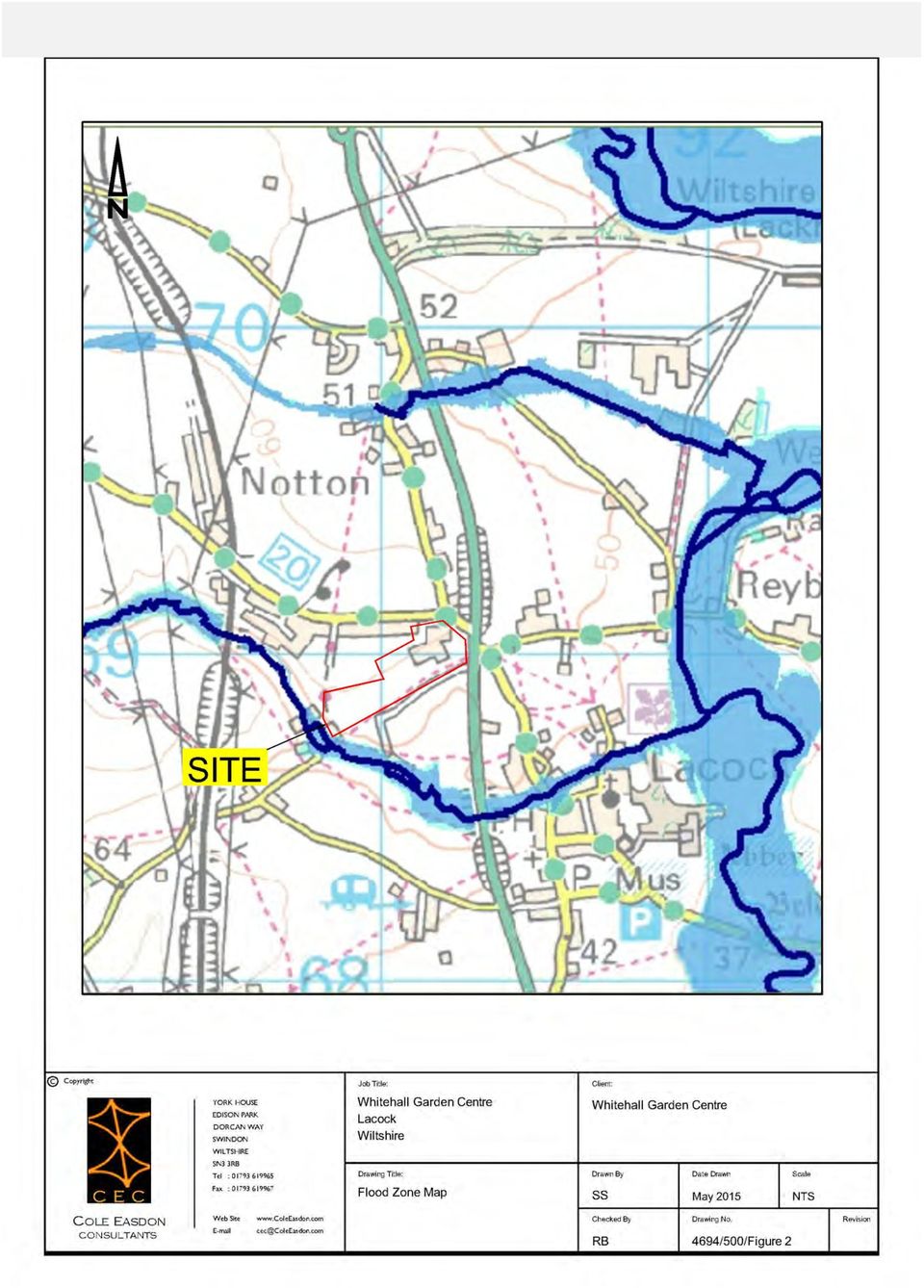
7 FLOOD RISK ASSESSMENT PROPOSED EXPANSION OF WHITEHALL GARDEN CENTRE, CORSHAM ROAD, LACOCK 2.0 THE EXISTING SITE Refer to CEC Figure 4694/500/Figure 1 [Site Location Plan] in Appendix 1 and CEC Plan 4694/500(A) [Existing Site Plan Sheets 1 & 2] in Appendix The site comprises a large garden centre complex covering 8.2ha. It is located approximately 300m north west of the village of Lacock. The site address is Whitehall Garden Centre, Corsham Road, Lacock, Chippenham Wiltshire, SN15 2LZ. National grid reference ST The site contains various buildings used as shops, restaurants and other customer facilities, in addition to external yards for storage, deliveries and plant display. A tarmac car park is located adjacent to the existing site access, in the north of the site. The western part of the site comprises a landscaped park and a large gravel car park. 2.3 The site forms an irregularly shaped parcel of land with a wooded boundary of mature trees and hedgerows. The northern site boundary is formed by Corsham Road and the gardens of properties fronting the road. A track named Rosemary Lane is routed along the site s western boundary, with farmland beyond. A public footpath forms the southern boundary of the site, with further farmland located further to the south. The A350 highway, and Corsham Road delineate the eastern margin of the site. 2.4 The site is accessed from Corsham Road. 2.5 Land use in the vicinity of the site is primarily agricultural. The nearest sizeable residential areas are Chippenham, approximately 3km to the north, and Lacock, 300m to the south east. 2.6 Ground levels within the site fall to the south. Existing ground levels vary between 64.00mAOD in the north western corner of the site, to 50.00mAOD at its south west corner. Nearby Watercourses/Drainage Features 2.7 The River Avon, a Main River, drains the local catchment. An unnamed tributary of the Avon flows in a south-easterly direction some 100m west of the site s western boundary. It flows through the farmland to the south of the site, and turns to flow east beneath the A350 and through the centre of Lacock. It meets its confluence with the River Avon to the east of Lacock, some 800m south east of the site. QMF ISSUE 5 Cole Easdon Consultants (CEC) 4 OCTOBER 2015

8 FLOOD RISK ASSESSMENT PROPOSED EXPANSION OF WHITEHALL GARDEN CENTRE, CORSHAM ROAD, LACOCK 2.8 A ditch is routed along the southern boundary of the site. It outfalls to a deep, steep sided gully near the south western corner of the site, which then discharges to the unnamed tributary at Pinnell s Mill. Existing Drainage/Sewers 2.9 The site is served by a private surface water drainage system comprising gullies, linear drains and gravity pipework with a connection to the existing ditch at the southern boundary of the site. The existing impermeable area at the site measures 23,000m Wessex Water sewer records confirm that a public foul sewer (225mm diameter) flows east along Corsham Road then turns to follow a south easterly course along the site frontage, then flows south east under Cantax Hill. Foul flows from the existing kitchens and lavatories in the eastern part of the site are pumped to this system from a holding tank located in a landscaped area to the south of the westerly garden centre building. A second pump is located in the east of the site and lifts effluent to a gravity foul drain which flows along the southern side of the eastern most garden centre building. Both systems outfall to a manhole adjacent to the site s eastern boundary which connects with the existing public foul sewer in the verge of the A350. The existing drainage system is highlighted on CEC Plan 4694/500(A) [Existing Site Plan Sheets 1 & 2] in Appendix 6. Refer to Appendix 5 for Wessex Water records. Existing Ground Conditions Refer to Geological Records in Appendix An intrusive site investigation has yet to be undertaken, however the British Geological Survey (BGS) Map indicates that the locality is underlain by bedrock known as Kellaways Formation which is composed of sandstone, siltstone and mudstone. These strata are overlain by variable Alluvial deposits of clay, silt, sand and gravel. The site is brownfield land therefore made ground is likely to be present beneath the existing buildings, hard surfaced areas and car parking areas Groundwater levels are currently unknown. The lowest lying land in the vicinity of the site is near its south eastern corner, within the existing gully feature. The bed of the gully is some 3m below the lowest part of the site however it remains dry and contains water only following rainfall, this being surface water runoff rather than groundwater. It is therefore reasonable to assume that the water table lies at least 3m below the lowest part of the site, and that it is significantly deeper over much of the more elevated parts of the site. QMF ISSUE 5 Cole Easdon Consultants (CEC) 5 OCTOBER 2015

9 FLOOD RISK ASSESSMENT PROPOSED EXPANSION OF WHITEHALL GARDEN CENTRE, CORSHAM ROAD, LACOCK 2.13 The contamination status of the site is unknown, and should be considered in due course as part of an Environmental Desk Study report EA mapping classifies the bedrock beneath the area as non aquifer. The superficial gravel deposits are termed a Secondary A Aquifer (formerly a Minor Aquifer) and as such may support water supply and river base flow on a local rather than strategic scale The EA s Groundwater Source Protection Zone Map confirms that the site lies within the innermost Groundwater Source Protection Zone, therefore water abstraction for sensitive usage is likely to occur in close proximity to the site. QMF ISSUE 5 Cole Easdon Consultants (CEC) 6 OCTOBER 2015
 and as such may support water supply and river base flow on a local rather than strategic scale. 2.")
10 FLOOD RISK ASSESSMENT PROPOSED EXPANSION OF WHITEHALL GARDEN CENTRE, CORSHAM ROAD, LACOCK 3.0 FLOOD RISK ISSUES Flood History 3.1 There is no history of flooding at the site recorded within the Strategic Flood Risk Assessment, nor the Surface Water Management Plan. 3.2 According to the documents listed above, the site is not within a Critical drainage Drainage Area. Refer to Appendix 5 for report excerpts. Fluvial/Tidal Flood Risk 3.3 The Environment Agency s Flood Zone Map (FZM) indicates that the site lies entirely within Flood Zone 1 (low risk) with less than a 1 in 1000 (0.1%) annual probability of fluvial or tidal flooding in any year. Refer to CEC Figure 4694/500/Figure 2 [Flood Zone Map] in Appendix Technical Guidance to the NPPF (Table 2: Flood Risk Vulnerability Classification) classifies the proposed site usage commercial as Less Vulnerable development. In accordance with the Technical Guidance to the NPPF (Table 3: Flood Risk Vulnerability and Flood Zone Compatibility), More Vulnerable developments are appropriate in Flood Zone Fluvial/tidal flood risk to the site is therefore low. Overland Runoff 3.6 The land in the immediate vicinity of the site is a largely undeveloped catchment including farmland and residential gardens. Surface water flows from this area will be limited to relatively minor greenfield runoff. The existing impermeable catchment within the site, along with the new buildings and hard paved areas will be directed to a new Sustainable Urban Drainage System (SUDS). This facility will accommodate any surface water runoff generated by the site, and will be designed with the capacity to contain the 1% + CC storm, in accordance with NPPF requirements. Refer to Section 4 below. 3.7 Mapping within the Strategic Flood Risk Assessment indicates that there is no record of surface water flooding at the site. Instances of highway flooding have been recorded on Corsham road and the A350, to the east of the site. It is assumed that this flooding was a result of heavy rainfall and inadequate highway drainage infrastructure or blockage of the highway drainage system. Comparison of existing road levels with those within the site QMF ISSUE 5 Cole Easdon Consultants (CEC) 7 OCTOBER 2015
 indicates that the site lies entirely within Flood Zone 1 (low risk) with less than a 1 in 1000 (0.")
11 FLOOD RISK ASSESSMENT PROPOSED EXPANSION OF WHITEHALL GARDEN CENTRE, CORSHAM ROAD, LACOCK confirms that any floodwaters in the highway would follow the road gradient to the south without accumulating to depth or encroaching upon the site, which is elevated relative to the road. Refer to Appendix 5 for report excerpts. Refer to CEC Plan 4694/500(A) [Existing Site Plan Sheets 1 & 2] in Appendix Note that there will be no discharge of surface water into the existing highway drainage system as a result of the proposals. The proposed redevelopment will not therefore exacerbate any existing highway drainage issues. Refer to Section 4 below. 3.9 Flood risk from overland flows is therefore low. Sewer Flooding 3.10 Wessex Water records confirm that there is a public foul sewer located in the in Corsham Road which follows the northern and eastern boundaries of the site. This sewer is under the management of the sewerage undertaker and should therefore be properly designed and maintained. If the sewer system were to surcharge and flood, it is likely that floodwaters would be contained within the highway corridor and would flow away from the site, to the south The existing private surface water drainage system should also be capable of accommodating runoff from the existing impermeable catchment within the site, without flooding. Notwithstanding this, the SUDS drainage provided as part of the redevelopment scheme will be designed with capacity for the 1%+CC storm in accordance with NPPF guidance There is no record of sewer flooding at the site, or in its vicinity, within the Strategic Flood Risk Assessment. Refer to Appendix 5 for report excerpts The risk of flooding from existing sewers is low. Groundwater Flooding 3.14 There is no record of groundwater flooding at the site, or in its vicinity, within the Strategic Flood Risk Assessment. Refer to Appendix 4 for report excerpts. QMF ISSUE 5 Cole Easdon Consultants (CEC) 8 OCTOBER 2015

12 FLOOD RISK ASSESSMENT PROPOSED EXPANSION OF WHITEHALL GARDEN CENTRE, CORSHAM ROAD, LACOCK 3.15 Groundwater levels are unknown at present, however the water table is probably in hydraulic continuity with the base of the valley of the unnamed watercourse and gully to the south west of the site, which is considerably lower than the lowest part of the site. In view of this it is unlikely that groundwater levels could rise sufficiently to cause flooding. In the event that groundwater emergence would ever occur within the site, it would drain off site, to the south, without accumulating to depth within the development The risk of groundwater flooding is low. QMF ISSUE 5 Cole Easdon Consultants (CEC) 9 OCTOBER 2015

13 FLOOD RISK ASSESSMENT PROPOSED EXPANSION OF WHITEHALL GARDEN CENTRE, CORSHAM ROAD, LACOCK 4.0 PROPOSED DRAINAGE STRATEGY Surface Water Refer to CEC Plan 4694/501(A) [Proposed Drainage Strategy Sheets 1 & 2] in Appendix Post development runoff will be discharged to the existing ditch at the site s southern boundary, as per the current arrangement. 4.2 The impermeable area at the site will be increased from 23,000m 2 to 46,500m 2 under the proposals, which will result in an increased surface water runoff rate. Without appropriate mitigation measures, this runoff could increase flood risk to the locality. 4.3 It is therefore proposed that post development discharge is reduced to the site s undeveloped, greenfield runoff rate. A 1 in 100 year greenfield runoff rate of 12 l/s has been calculated for the site. Refer to ICP for SuDS - IH124 Methodology Microdrainage software calculations in Appendix 3. The proposed flow restriction will ensure that there is no increase risk of flooding to downstream areas, and will in fact provide betterment over the existing situation, whereby surface water runoff from the site is discharged at an uncontrolled rate, and no storage system is present. 4.4 In accordance with NPPF guidance, on site Sustainable Urban Drainage Systems (SUDS) will be provided and will contain capacity for flows from the 1 in 100 year storm event, including an extra allowance of 30% to accommodate the predicted future impact of climate change upon rainfall patterns. 4.5 Preliminary calculations indicate that approximately 5,000m 3 on site storage will be required to accommodate the design storm. It is proposed that this volume is provided within a cellular storage SUDS system, such as Aquacell or similar approved, to be installed in the south western corner of the site, beneath the proposed car parking area. The proposed SUDS system layout is shown on CEC Plan 4694/501(A) [Proposed Drainage Strategy Sheets 1 & 2], enclosed within Appendix 6, together with a proposed surface water drainage network design. Calculations relating the drainage system can be found in Appendix 3. All calculations have been undertaken using Windes Microdrainage software. 4.6 Post development flows will be restricted by means of a hydrobrake, orifice or similar flow control device. QMF ISSUE 5 Cole Easdon Consultants (CEC) 10 OCTOBER 2015

14 FLOOD RISK ASSESSMENT PROPOSED EXPANSION OF WHITEHALL GARDEN CENTRE, CORSHAM ROAD, LACOCK Adoption 4.7 The SUDS system will be managed privately as part of the overall maintenance regime of the site. 4.8 Maintenance should be carried out in accordance with CIRIA SUDS MANUAL (2007) guidance, as shown in Table 4.1 below: Table 4.1: Maintenance Schedule Cellular Storage Operation and Maintenance Requirements Required Action Recommended Frequency Inspect and identify any areas that are not operating correctly. If required, take remedial action. Monthly for 3 months, then six monthly. Regular Maintenance Debris removal from catchment surface (where may cause risks to performance). Where rainfall infiltrates into blocks from above, check surface of filter for blockage by silt, algae or other matter. Remove and replace surface infiltration medium as necessary. Remove sediment from pre-treatment structures. Monthly. Monthly (and after large storms). Annually, or as required. Remedial Actions Monitoring Repair/rehabilitation of inlets, outlets, overflows and vents. Inspect/check all inlets, outlets, vents and overflows to ensure that they are in good condition and operating as designed. As required. Annually and after large storms. Water Quality 4.9 A bypass separator will be installed up stream of the proposed SUDS system. This will provide water quality treatment for runoff from the highway and parking areas, which could contain hydrocarbon pollutants from fuel and oil leaks or spillage. Further management of water quality will be provided by trap gullies which will retain particulates and any adhering contaminants. Rainwater Harvesting Refer to CEC Plan 4694/501(A) [Proposed Drainage Strategy Sheets 1 & 2] in Appendix The garden centre uses substantial volumes of water for irrigation. Any reduction in reliance on potable water supply will be beneficial economically and in terms of the sustainability of the site. It is therefore proposed that a rainwater harvesting tank is situated in one of the southern service yards. The tank will operate as part of the proposed surface water pipe network as an on line facility. The effective storage volume of the tank QMF ISSUE 5 Cole Easdon Consultants (CEC) 11 OCTOBER 2015
.")
15 FLOOD RISK ASSESSMENT PROPOSED EXPANSION OF WHITEHALL GARDEN CENTRE, CORSHAM ROAD, LACOCK will be located beneath the invert level of the incoming and outgoing surface water drain such that when full the system will be by passed. Water will be removed for use by pumping The proposed tank volume is 555m 3 which is based on an average 2 weeks summer supply for year Refer to Appendix 3 for annual consumption figures. Foul Water Refer to CEC Plan 4694/501(A) [Proposed Drainage Strategy Sheets 1 & 2] in Appendix Foul flows from the site are presently disposed of by discharge to the existing public foul sewer in Corsham Road/A350. This arrangement will be maintained under the proposals As discussed in Section 2, at present 2No pump systems are employed to drain the site. It is proposed that a new piped gravity system be constructed to outfall to a new pumping station located in the south east corner of the site, on the southern side of the service road. Foul water will be pumped to the existing private chamber adjacent to the site s eastern boundary, from where it will gravitate to the existing public foul sewer The redevelopment scheme entails the addition of customer and staff lavatories, and kitchen waste water. The increase in loadings from these areas will be minimal and are not expected to impact upon the operation of the existing public foul sewer system. Any connection will be subject to Wessex Water approval at the appropriate time. QMF ISSUE 5 Cole Easdon Consultants (CEC) 12 OCTOBER 2015
 [Proposed Drainage Strategy Sheets 1 & 2] in Appendix 6. 4.12 Foul flows from the site are presently disposed of by discharge to the existing public foul sewer in Corsham Road/A350.")
16 FLOOD RISK ASSESSMENT PROPOSED EXPANSION OF WHITEHALL GARDEN CENTRE, CORSHAM ROAD, LACOCK 5.0 SUMMARY AND CONCLUSIONS 5.1 Flood risk to the proposed development from fluvial sources, overland flow, sewers and groundwater has been considered in this study. No significant risks have been identified. 5.2 The site lies within Flood Zone 1 (Low Risk) according to the FZM produced by the EA. As such, in accordance with NPPF guidance, redevelopment of the site for commercial purposes is appropriate. 5.3 Surface water discharge from the site is therefore the primary flood risk associated with the proposals. In order to mitigate flood risk from this source, post development flows will be restricted to the site s existing greenfield runoff rate; this represents significant betterment over the existing arrangement whereby flows from the extensive impermeable catchment within the garden centre are discharged without restriction. In addition, a large on site Sustainable Urban Drainage System is proposed in the form of a cellular tank facility. This will allow on site storage of flows arising from the 1 in 100 year event, including an allowance for future climate change, without increasing discharge to the receiving watercourse. 5.4 Rainwater harvesting will be employed to reduce the consumption of potable water for the purposes of irrigation and to improve the overall sustainability of the site. A tank will be provided in the southern service yard and will enable storage of 555m 3 of water, or 2 weeks average summer supply. 5.5 Post development foul flows will be discharge to the existing public foul sewer in Corsham Road/A350, as per the existing situation. The existing foul drainage system and pumps will be replaced with a new pipe network and a new pumping station. 5.6 This study has been undertaken in accordance with the principles of the NPPF document. We conclude that providing the development adheres to the conditions advised within this report, the proposals can be accommodated without increasing flood risk within the locality in accordance with objectives set by Central Government and the EA. Cole Easdon Consultants Limited October 2015 QMF ISSUE 5 Cole Easdon Consultants (CEC) 13 OCTOBER 2015

17 Appendix 1

18

19
20 Appendix 2

21
22
23 Appendix 3
24 Cole Easdon Consultants Page 1 York House, Edison Park Dorcan Way Swindon, SN3 3RB Date 21/09/ :41 Designed by sstarr File 4694 SW NETWORK.MDX Checked by Elstree Computing Ltd Network STORM SEWER DESIGN by the Modified Rational Method Design Criteria for Storm Pipe Sizes STANDARD Manhole Sizes STANDARD FSR Rainfall Model - England and Wales Return Period (years) 100 Add Flow / Climate Change (%) 0 M5-60 (mm) Minimum Backdrop Height (m) Ratio R Maximum Backdrop Height (m) Maximum Rainfall (mm/hr) 50 Min Design Depth for Optimisation (m) Maximum Time of Concentration (mins) 30 Min Vel for Auto Design only (m/s) 1.00 Foul Sewage (l/s/ha) Min Slope for Optimisation (1:X) 500 Volumetric Runoff Coeff Designed with Level Soffits Time Area Diagram for Storm Time (mins) Area (ha) Time (mins) Area (ha) Time (mins) Area (ha) Total Area Contributing (ha) = Total Pipe Volume (m³) = Network Design Table for Storm PN Length (m) Fall (m) Slope (1:X) I.Area (ha) T.E. (mins) Base Flow (l/s) k (mm) HYD SECT DIA (mm) Auto Design o o o o o o o 825 Network Results Table PN Rain (mm/hr) T.C. (mins) US/IL (m) Σ I.Area (ha) Σ Base Flow (l/s) Foul (l/s) Add Flow (l/s) Vel (m/s) Cap (l/s) Flow (l/s) XP Solutions
25 Cole Easdon Consultants Page 2 York House, Edison Park Dorcan Way Swindon, SN3 3RB Date 21/09/ :41 Designed by sstarr File 4694 SW NETWORK.MDX Checked by Elstree Computing Ltd Network Network Design Table for Storm PN Length (m) Fall (m) Slope (1:X) I.Area (ha) T.E. (mins) Base Flow (l/s) k (mm) HYD SECT DIA (mm) Auto Design o o o o o o o o o o o o o o o o o 900 Network Results Table PN Rain (mm/hr) T.C. (mins) US/IL (m) Σ I.Area (ha) Σ Base Flow (l/s) Foul (l/s) Add Flow (l/s) Vel (m/s) Cap (l/s) Flow (l/s) XP Solutions
26 Cole Easdon Consultants Page 3 York House, Edison Park Dorcan Way Swindon, SN3 3RB Date 21/09/ :41 Designed by sstarr File 4694 SW NETWORK.MDX Checked by Elstree Computing Ltd Network Free Flowing Outfall Details for Storm Outfall Pipe Number Outfall Name C. Level (m) I. Level (m) Min I. Level (m) D,L (mm) W (mm) Simulation Criteria for Storm Volumetric Runoff Coeff Additional Flow - % of Total Flow Areal Reduction Factor MADD Factor * 10m³/ha Storage Hot Start (mins) 0 Inlet Coeffiecient Hot Start Level (mm) 0 Flow per Person per Day (l/per/day) Manhole Headloss Coeff (Global) Run Time (mins) 60 Foul Sewage per hectare (l/s) Output Interval (mins) 1 Number of Input Hydrographs 0 Number of Storage Structures 1 Number of Online Controls 1 Number of Time/Area Diagrams 0 Number of Offline Controls 0 Number of Real Time Controls 0 Synthetic Rainfall Details Rainfall Model FSR Profile Type Summer Return Period (years) 100 Cv (Summer) Region England and Wales Cv (Winter) M5-60 (mm) Storm Duration (mins) 30 Ratio R XP Solutions
27 Cole Easdon Consultants Page 4 York House, Edison Park Dorcan Way Swindon, SN3 3RB Date 21/09/ :41 Designed by sstarr File 4694 SW NETWORK.MDX Checked by Elstree Computing Ltd Network Online Controls for Storm Hydro-Brake Optimum Manhole: 24, DS/PN: 1.012, Volume (m³): 83.2 Unit Reference MD-SHE Design Head (m) Design Flow (l/s) 12.0 Flush-Flo Calculated Objective Minimise upstream storage Diameter (mm) 143 Invert Level (m) Minimum Outlet Pipe Diameter (mm) 225 Suggested Manhole Diameter (mm) 1500 Control Points Head (m) Flow (l/s) Design Point (Calculated) Flush-Flo Kick-Flo Mean Flow over Head Range The hydrological calculations have been based on the Head/Discharge relationship for the Hydro-Brake Optimum as specified. Should another type of control device other than a Hydro-Brake Optimum be utilised then these storage routing calculations will be invalidated Depth (m) Flow (l/s) Depth (m) Flow (l/s) Depth (m) Flow (l/s) Depth (m) Flow (l/s) XP Solutions
28 Cole Easdon Consultants Page 5 York House, Edison Park Dorcan Way Swindon, SN3 3RB Date 21/09/ :41 Designed by sstarr File 4694 SW NETWORK.MDX Checked by Elstree Computing Ltd Network Storage Structures for Storm Tank or Pond Manhole: 24, DS/PN: Invert Level (m) Depth (m) Area (m²) Depth (m) Area (m²) Depth (m) Area (m²) XP Solutions
29 Cole Easdon Consultants Page 6 York House, Edison Park Dorcan Way Swindon, SN3 3RB Date 21/09/ :41 Designed by sstarr File 4694 SW NETWORK.MDX Checked by Elstree Computing Ltd Network Summary Wizard of 15 minute 1 year Summer I+0% for Storm Simulation Criteria Areal Reduction Factor Additional Flow - % of Total Flow Hot Start (mins) 0 MADD Factor * 10m³/ha Storage Hot Start Level (mm) 0 Inlet Coeffiecient Manhole Headloss Coeff (Global) Flow per Person per Day (l/per/day) Foul Sewage per hectare (l/s) Number of Input Hydrographs 0 Number of Storage Structures 1 Number of Online Controls 1 Number of Time/Area Diagrams 0 Number of Offline Controls 0 Number of Real Time Controls 0 Synthetic Rainfall Details Rainfall Model FSR Ratio R Region England and Wales Cv (Summer) M5-60 (mm) Cv (Winter) Margin for Flood Risk Warning (mm) DVD Status OFF Analysis Timestep Fine Inertia Status OFF DTS Status ON Profile(s) Summer and Winter Duration(s) (mins) 15, 30, 60, 120, 180, 240, 360, 480, 600, 720, 960, 1440, 2160, 2880, 4320, 5760, 7200, 8640, Return Period(s) (years) 1, 30, 100 Climate Change (%) 0, 0, 30 PN US/MH Name Rank Water Level (m) Surch'ed Depth (m) Flooded Volume (m³) Flow / Cap. O'flow (l/s) Pipe Flow (l/s) Status OK OK OK OK OK OK OK OK OK OK OK OK OK OK OK OK OK OK OK OK OK XP Solutions
30 Cole Easdon Consultants Page 7 York House, Edison Park Dorcan Way Swindon, SN3 3RB Date 21/09/ :41 Designed by sstarr File 4694 SW NETWORK.MDX Checked by Elstree Computing Ltd Network Summary Wizard of 15 minute 1 year Summer I+0% for Storm PN US/MH Name Rank Water Level (m) Surch'ed Depth (m) Flooded Volume (m³) Flow / Cap. O'flow (l/s) Pipe Flow (l/s) Status OK OK OK XP Solutions
31 Cole Easdon Consultants Page 8 York House, Edison Park Dorcan Way Swindon, SN3 3RB Date 21/09/ :41 Designed by sstarr File 4694 SW NETWORK.MDX Checked by Elstree Computing Ltd Network Rainfall Hyetograph for 15 minute 1 year Summer I+0% (Storm) Time (mins) Rain (mm/hr) Time (mins) Rain (mm/hr) Time (mins) Rain (mm/hr) Time (mins) Rain (mm/hr) Time (mins) Rain (mm/hr) XP Solutions
32 Cole Easdon Consultants Page 1 York House, Edison Park Dorcan Way Swindon, SN3 3RB Date 15/09/ :38 Designed by sstarr File Checked by Elstree Computing Ltd Source Control ICP SUDS Mean Annual Flood Input Return Period (years) 100 Soil Area (ha) Urban SAAR (mm) 766 Region Number Region 7 Results l/s QBAR Rural 3.7 QBAR Urban 3.7 Q100 years 11.8 Q1 year 3.1 Q30 years 8.4 Q100 years XP Solutions
33 WATER CONSUMPTION 2014/15 IRRIGATION UNIT MAINS UNIT PERIOD CONSUMPTION CUBIC METERS LACOCK 2/9/14-2/10/ /10/14-5/11/ /11/14-2/12/ /12/14-6/1/ /1/15-2/2/ /2/15-3/3/ /3/15-1/4/ /4/15-5/5/ /5/15-2/6/ /6/15-2/7/ /7/15-3/8/ /8/15-1/9/ ANNUAL WATER CONSUMPTION
34 Appendix 4
35
Proposed Residential Development Land off Cody Road Waterbeach Cambridgeshire. Flood Risk Assessment
 Land off Cody Road Waterbeach Cambridgeshire Cedar Barn, White Lodge, Walgrave, Northampton, NN6 9PY T: F: E: W: 01604 781811 01604 781999 mail@jppuk.net jppuk.net Proposed Residential Development Land
WEST LONDON PIPELINE AND STORAGE LIMITED AND UNITED KINGDOM OIL PIPELINES LIMITED
 WEST LONDON PIPELINE AND STORAGE LIMITED AND UNITED KINGDOM OIL PIPELINES LIMITED WLPS BUNCEFIELD REBUILD Flood Risk Assessment Green Lane Hemel Hempstead Hertfordshire HP2 7HZ September 2009 Prepared
NOVEMBER 2009 [ISSUE 5]
![NOVEMBER 2009 [ISSUE 5]](/thumbs/28/12834647.jpg "NOVEMBER 2009 [ISSUE 5]") 375 401 BRIGHTON ROAD CROYDON FLOOD RISK ASSESSMENT CLIENT: TRITHING LTD [ISSUE 5] Head Office: Unit 2 York House Edison Park Dorcan Way Swindon Wiltshire SN3 3RB Tel. 01793 619965 Fax. 01793 619967 Email:
375 401 BRIGHTON ROAD CROYDON FLOOD RISK ASSESSMENT CLIENT: TRITHING LTD [ISSUE 5] Head Office: Unit 2 York House Edison Park Dorcan Way Swindon Wiltshire SN3 3RB Tel. 01793 619965 Fax. 01793 619967 Email:
Flood Risk Assessment and Drainage Statement
 Trinity College, Cambridge Proposed Relocation of Felixstowe Rifle Range, Land north of Nicholas Road, Trimley St Mary, Felixstowe Quality Assurance Site name: Client name: Proposed Relocation of Felixstowe
Vital Earth Composting Facility Flood Risk and Drainage Statement
 Vital Earth Flood Risk and Drainage Statement Final December 2011 Prepared for Vital Earth Ltd Revision Schedule Flood Risk and Drainage Statement December 2011 Rev Date Details Prepared by Reviewed by
DECEMBER 2008 [ISSUE 2]
![DECEMBER 2008 [ISSUE 2]](/thumbs/40/21568937.jpg "DECEMBER 2008 [ISSUE 2]") PROPOSED DEVELOPMENT WEST SUSSEX FLOOD RISK ASSESSMENT CLIENT: ARORA MANAGEMENT SERVICES LIMITED [ISSUE 2] Warrington Office Cinnamon House Cinnamon Park Crab Lane Fearnhead Warrington Cheshire WA2 0XP
PROPOSED DEVELOPMENT WEST SUSSEX FLOOD RISK ASSESSMENT CLIENT: ARORA MANAGEMENT SERVICES LIMITED [ISSUE 2] Warrington Office Cinnamon House Cinnamon Park Crab Lane Fearnhead Warrington Cheshire WA2 0XP
DRAINAGE MANAGEMENT PLAN. HERTFORDSHIRE RESIDUAL WASTE TREATMENT PLANT Hertfordshire County Council
 DRAINAGE MANAGEMENT PLAN HERTFORDSHIRE RESIDUAL WASTE TREATMENT PLANT Hertfordshire County Council EMPLOYER: Veolia Environmental Services (UK) Plc Veolia House 154A Pentonville Road London N1 9PE Copy
FLOOD RISK AND SURFACE WATER DRAINAGE ASSESSMENT HILLHOUSE RESTORATION SITE, OFF JAMESON ROAD, THORNTON CLEVELEYS ON BEHALF OF NPL ESTATES
 FLOOD RISK AND SURFACE WATER DRAINAGE ASSESSMENT HILLHOUSE RESTORATION SITE, OFF JAMESON ROAD, THORNTON CLEVELEYS ON BEHALF OF NPL ESTATES Integra Consulting Engineers Limited NS / 2543 Fountain House
Development at 2 St Albans Road, Kingston, London, KT25HQ
 Development at SuDS Report. Prepared for: Report prepared by: Dave Alonso Divine Ideas (UK) ltd Date: August 2015 Project/Issue number: Appendices Attached: 1510/01/SuDS A, B & C Divine Ideas (UK) Ltd
Taylor Wimpey UK Ltd. December 2007
 Taylor Wimpey UK Ltd December 2007 QM Issue/revision Issue 1 Revision 1 Revision 2 Revision 3 Remarks Draft For Planning Date 3 August 2007 20 December 2007 Prepared by D Gooding P Barton Signature Checked
FLOOD RISK ASSESSMENT AND DRAINAGE STRATEGY
 FLOOD RISK ASSESSMENT AND DRAINAGE STRATEGY London Rd. WATERLOOVILE FOR McCarthy & Stone Ltd. July 2010 Such Salinger Peters Ltd 30558-1- Flood Risk Assessment & Drainage Strategy Contents Paragraph Page
Newbiggin House Farm,
 Newbiggin House Farm, Near Waberthwaite Flood Investigation Report 32 Flood Event 30/8/2012 Cumbria County Council Version Undertaken by Reviewed by Approved by Date Preliminary Colin Parkes Anthony Lane
Recommendations for future developments
 C Recommendations for future developments C.1 Reducing flood risk through site layout and design C.1.1 C.1.2 Flood risk should be considered at an early stage in deciding the layout and design of a site
Proposed Construction of Basement Flood Risk Assessment. 35 Edwardes Square London W8 6HH
 Proposed Construction of Basement Flood Risk Assessment 35 Edwardes Square London W8 6HH 1 Introduction This FRA has been carried out in accordance with the National Planning Policy Statement (NPPF), the
East Riding of Yorkshire Council
 East Riding of Yorkshire Council Lead Local Flood Authority Interim Standing Advice Revision A - April 2015 1. Introduction From April 2015 the Lead Local Flood Authority (LLFA) became a statutory consultee
Essex County Council Flood Investigation Report
 Essex County Council Stock City of Chelmsford Rev Date Details Author Checked and Approved By 01 February 2015 Draft report for stakeholder consultation Ed Clarke Flood Investigation Engineer Lucy Shepherd
SUSTAINABLE URBAN DRAINAGE SYSTEMS
 overflow can lead into a permeable conveyance system to increase further the benefit and reduce the need for pipe systems. Pollutant removal rates have been shown to be high, with some pollutants being
London Road, Rayleigh Essex Flood Risk Assessment Addendum
 FINAL Countryside Properties (UK) Limited Submitted by AECOM 6-8 Greencoat Place London SW1P 1PL London Road, Rayleigh Essex Flood Risk Assessment May 2015 i Limitations AECOM Infrastructure & Environment
Littleport Co-located Schools
 Littleport Co-located Schools February 2015 Morgan Sindall Littleport Co-located Schools 330763 BNI BSE 003 C P:\Cambridge\Murdoch\EST\PROJECTS\330763 Littleport Co-located Schools\12.0 Documents\12.2
Pollution Control NEW! NEW! Stormwater Attenuation Systems Sustainable Urban Drainage Solutions for Domestic & Commercial Applications. klargester.
 Pollution Control NEW! NEW! Stormwater Attenuation Systems Sustainable Urban Drainage Solutions for Domestic & Commercial Applications klargester.com Stormwater Attenuation Systems Sustainable Urban Drainage
Flood Risk Assessment and Drainage Impact Assessment: Planning Guidance for Developers
 Flood Risk Assessment and Drainage Impact Assessment: Planning Guidance for Developers Development and Regeneration Services Glasgow City Council 229 George Street Glasgow G1 1QU May 2011 1. Introduction...-
London Borough of Croydon Local Flood Risk Management Strategy
 London Borough of Croydon Local Flood Risk Management Strategy Summary 2014-2020 Introduction In response to the severe flooding across large parts of England and Wales in summer 2007, the Government has
London Borough of Merton Local Flood Risk Management Strategy
 Local Flood Risk Management Strategy Summary 2014-2020 Introduction In response to the severe flooding across large parts of England and Wales in summer 2007, the Government has recently enacted the Flood
Chippenham Surface Water Management Plan Intermediate Assessment of Groundwater Flooding Susceptibility
 Chippenham Surface Water Management Plan Intermediate Assessment of Groundwater Flooding Susceptibility Phase 1 & 2 November 2011 Prepared for Revision Schedule Surface Water Management Plan Intermediate
Action plans for hotspot locations - Ash Study
 Appendix 9 Action plans for hotspot locations - Ash Study Ash Vale North 1. Local evidence indicates the culvert could not discharge during December 2013 because the outlet was blocked on the western side
Chapter 9: Water, Hydrology and Drainage Land West of Uttoxeter
 Chapter 9: Water, Hydrology and Drainage Land West of Uttoxeter ENVIRONMENTAL STATEMENT: VOLUME 1 9.1 INTRODUCTION 9.1.1 This Chapter considers the effects of the Project on surface water and groundwater
UPDATED FUNCTIONAL SERVICING and STORMWATER MANAGEMENT REPORT
 TRAFALGAR ENGINEERING LTD. #1-481 Morden Road Oakville Ontario L6K 3W6 UPDATED FUNCTIONAL SERVICING and STORMWATER MANAGEMENT REPORT Fernbrook Homes (Bronte 15) Limited 3059/3047 Lakeshore Road West TOWN
Bolton s Flood Risk Management Strategy
 Bolton s Flood Risk Management Strategy www.bolton.gov.uk Public Summary Bolton s Flood Risk Management Strategy Public Summary Introduction Over 5.5 million properties in England and Wales are at risk
London Borough of Waltham Forest LOCAL FLOOD RISK MANAGEMENT STRATEGY. Summary Document
 LOCAL FLOOD RISK MANAGEMENT STRATEGY Summary Document October 2013 Local Flood Risk Management Strategy Summary 1 Introduction 2 Partner responsibilities 3 What do we know about flooding in the borough?
Guidance Notes: GARDEN FLOODING
 Page 1 of 7 Guidance Notes: GARDEN FLOODING If you are unsure about anything within these notes then please contact the Flood Risk Management (FRM) team using the details at the end of this document. Water
INFRASTRUCTURE, FLOOD PROTECTION AND REMEDIATION. Infrastructure Flood Protection Remediation Policies
 INFRASTRUCTURE, FLOOD PROTECTION AND REMEDIATION Infrastructure Flood Protection Remediation Policies DRAFT POOLBEG PLANNING SCHEME 196 FIGURE 9.1: UTILITIES WAYLEAVES Electricity Cables 8m Wayleave for
Granville Road Estate, London Borough of Barnet. Flood Risk Assessment and Drainage Strategy August 2014. New Granville LLP
 Granville Road Estate, London Borough of Barnet Flood Risk Assessment and Drainage Strategy August 2014 New Granville LLP Document History JOB NUMBER: 237 DOCUMENT REF: Granville Road FRA REVISIONS: Final
1.2 This technical note provides a preliminary investigation into the Flood Risk and provides outline drainage strategies.
 ODYSSEY MARKIDES TECHNICAL NOTE PROJECT : CHAILEY HOUSE, BLEWBURY JOB NO. : 14-216 NOTE TITLE : PRELIMINARY FLOODING AND DRAIANGE AUTHOR : STEVEN ROOTH APPROVED : ANDREAS MARKIDES DATE : 02/09/2014 1.0
ORCHARD WAY / BROOM GROVE Knebworth
 ORCHARD WAY / BROOM GROVE Knebworth Technical Assessment Report to support Section 19 Flood Investigation Project No: Date: Reviewed By: Approved By: 0469 October 2014 Tom Butler Neil Harding NHTB Consultancy
Planning, Health and Environment Division
 18 Planning, Health and Environment Division A Planning Guide to Sustainable Drainage Systems Introduction Working in co-operation with the Environment Agency, Severn Trent Water Ltd., the Highway Authority
Type of Sewer Systems. Solomon Seyoum
 Type of Sewer Systems Solomon Seyoum 0 Learning objectives Upon completion of this lecture, the participants will be able to differentiate between types of sewer systems and discuss different aspects of
Anglian Water Services Limited. Sustainable drainage systems (SUDS) adoption manual
 adoption manual") Anglian Water Services Limited i towards sustainable water stewardship Sustainable drainage systems (SUDS) adoption manual Anglian Water Services Limited 1 Tomorrow s forecast is more frequent, more violent
Anglian Water Services Limited i towards sustainable water stewardship Sustainable drainage systems (SUDS) adoption manual Anglian Water Services Limited 1 Tomorrow s forecast is more frequent, more violent
Flood Risk Assessment Breakspear House, Hemel Hempstead. Kier Property. October 08
 Flood Risk Assessment Breakspear House, Hemel Hempstead. Kier Property October 08 Prepared by:... Approved by:... Simon Marcos Keith Searle Principal Engineer Associate Director Flood Risk Assessment Rev
11.2 The proposals to deal with the leachate within the closed Lodmoor North Landfill site are assessed in Chapter 10 Geology and Soils.
 Chapter Eleven Water Quality, Drainage and Hydrogeology Introduction 11.1 This Chapter considers the impact of the Relief Road on the hydrology of the area and considers both surface and groundwater. Runoff
WILLOCHRA BASIN GROUNDWATER STATUS REPORT 2009-10
 WILLOCHRA BASIN GROUNDWATER STATUS REPORT 2009-10 SUMMARY 2009-10 The Willochra Basin is situated in the southern Flinders Ranges in the Mid-North of South Australia, approximately 50 km east of Port Augusta
DESCRIPTION OF STORMWATER STRUCTURAL CONTROLS IN MS4 PERMITS
 DESCRIPTION OF STORMWATER STRUCTURAL CONTROLS IN MS4 PERMITS Phase I MS4 permits require continuous updating of the stormwater system inventory owned and operated by the MS4. They also include inspection
Sustainable Drainage Systems (SUDS) A guide for developers
 A guide for developers") Sustainable Drainage Systems (SUDS) A guide for developers We are the Environment Agency. It s our job to look after your environment and make it a better place for you, and for future generations. Your
Sustainable Drainage Systems (SUDS) A guide for developers We are the Environment Agency. It s our job to look after your environment and make it a better place for you, and for future generations. Your
Report Relating to Incidents of Flooding within the Dollar Catchment
 Joint Position Statement Report Relating to Incidents of Flooding within the Dollar Catchment October 2012 Eric McQuarrie, Scottish Water Stuart Cullen, Clackmannanshire Council TABLE OF CONTENTS 1. INTRODUCTION...
Groundwater Flooding: a UK Perspective
 Groundwater Flooding: a UK Perspective David Macdonald British Geological Survey Maclean Building Crowmarsh Gifford Wallingford OX10 8BB Tel 01491 838800 NERC All rights reserved Talk outline Definition
SOAK UP YOUR STORMWATER
 SOAK UP YOUR STORMWATER This booklet explains how you can apply soakage on your property to achieve efficient disposal of stormwater. The following information on soakage is intended as a guide only. All
Creating the environment for business
 1. Introduction 1.1 Introduction to Water Cycle Strategies (WCS) 1.1.1 Background The water cycle describes the pathways and processes through which water moves through the natural and built environment,
Designed and produced by geo-graphicsdesign.com DP 300 3/02
 Designed and produced by geo-graphicsdesign.com DP 300 3/02 Guidance for Developers and Regulators Purpose This booklet is produced on behalf of the North East Scotland Flooding Advisory Group and is intended
MAP KEYS GLOSSARY FOR THE DRAINAGE AND WATER REPORT
 Record MAP KEYS GLOSSARY FOR THE DRAINAGE AND WATER REPORT Abandoned Gravity Private Combined Gravity Private Foul Gravity Private Surface Water Gravity Public Combined Gravity Public Foul Gravity Public
Sutton Harbour Holdings PLC. March 2007
 Sutton Harbour Holdings PLC March 2007 Contents!! " # # $ % % &'(&'' ) ) ( * + ', *!$ -,!'! #. / $$ #% 00& ' 00&1 $ Executive Summary!! " WSP Development and Transportation has been engaged by Sutton
To prevent increased stormwater runoff entering Council s drainage system and causing overloading of the system that in turn might cause flooding.
 Background & Issues To provide guidelines and requirements for Developers, the Community and the Shire s Planning and Sustainability officers for connection to the Shire s Stormwater Drainage Disposal
1 in 30 year 1 in 75 year 1 in 100 year 1 in 100 year plus climate change (+30%) 1 in 200 year
 1 in 200 year") Appendix C1 Surface Water Modelling 1 Overview 1.1 The Drain London modelling was designed to analyse the impact of heavy rainfall events across each London borough by assessing flow paths, velocities
Appendix C1 Surface Water Modelling 1 Overview 1.1 The Drain London modelling was designed to analyse the impact of heavy rainfall events across each London borough by assessing flow paths, velocities
Issue: 2 Adopted by Council: 20/02/07. Directorate of Environment and Regeneration Planning Services
 Issue: 2 Adopted by Council: 20/02/07 Directorate of Environment and Regeneration Planning Services LOCAL PLANNIING GUIIDANCE NOTE NO..19:: SUSTAIINABLE DRAIINAGE SYSTEMS Background The provision of adequate
Carterton Drainage Strategy. Stage 1 - Initialise/Prepare
 Carterton Drainage Strategy Stage 1 - Initialise/Prepare Introduction Why sewer flooding Britain s first sewerage systems were constructed 150 years ago in the Victorian era, and have served us well for
Guidance on the use of sustainable drainage systems (SUDS) and an overview of the adoption policy introduced by
 and an overview of the adoption policy introduced by") Guidance on the use of sustainable drainage systems (SUDS) and an overview of the adoption policy introduced by Easy guide to Sustainable drainage systems 02 Contents Page Introduction 05 Purpose of this
Guidance on the use of sustainable drainage systems (SUDS) and an overview of the adoption policy introduced by Easy guide to Sustainable drainage systems 02 Contents Page Introduction 05 Purpose of this
Household customer. Wastewater flooding guidelines. www.thameswateruk.co.uk
 Household customer Wastewater flooding guidelines www.thameswateruk.co.uk We are very sorry that you have recently suffered wastewater flooding to your property. This leaflet has been designed to answer
Thames Water key Messages for London Borough of Ealing 25 th October 2005
 Thames Water key Messages for London Borough of Ealing 25 th October 2005 Item 1: Drainage & ownership The area of drainage is complex. Thames Water, the Local Authority, the Environment Agency and property
Micromanagement of Stormwater in a Combined Sewer Community for Wet Weather Control The Skokie Experience
 Micromanagement of Stormwater in a Combined Sewer Community for Wet Weather Control The Skokie Experience Robert W. Carr 1 * and Stuart G. Walesh 2 1 Water Resources Modeling, LLC, 4144 S. Lipton Ave,
Guidance on applying for approval of installation of a commercial onsite wastewater system
 Guidance on applying for approval of installation of a commercial onsite wastewater system This factsheet is designed to assist you to complete an Application to construct or install an apparatus for the
Catchment Scale Processes and River Restoration. Dr Jenny Mant Jenny@therrc.co.uk. The River Restoration Centre therrc.co.uk
 Catchment Scale Processes and River Restoration Dr Jenny Mant Jenny@therrc.co.uk The River Restoration Centre therrc.co.uk 3 Main Catchment Elements Hydrology Energy associated with the flow of water affects
Strategic Flood Risk Assessment
 local development framework Strategic Flood Risk Assessment LOCAL DEVELOPMENT FRAMEWORK ROYAL BOROUGH OF KINGSTON UPON THAMES Level 1 and 2 April 2011 Contents Executive Summary 5 Part 1 - Aiding Planning
APPENDIX 9 INFRASTRUCTURE SERVICING REPORT
 APPENDIX 9 INFRASTRUCTURE SERVICING REPORT Lot 50 Cockram Street, Mundijong Infrastructure Servicing Report Peet Ltd August 2012 LOT 50 COCKRAM STREET, MUNDIJONG-INFRASTRUCTURE SERVICING REPORT Project
SUSTAINABLE DRAINAGE IN LEEDS Supplementary Guidance No. 22 JULY 2004
 SUSTAINABLE DRAINAGE IN LEEDS Supplementary Guidance No. 22 JULY 2004 BACKGROUND This guidance provides information for developers on the use of sustainable drainage techniques in new developments. It
City of Shelbyville Site Inspection Checklist
 City of Shelbyville Site Inspection Checklist General Information Project Name: KYR10 Permit Number: Date: Project Location: Contractor: Conractor Representative: Inspector's Name: Title: Signature : Weather
2 ND SEPTEMBER 2014. Report of the Bi-Borough Executive Director for Transport and Technical Services
 London Borough of Hammersmith & Fulham COMMUNITY SAFETY, ENVIRONMENT & RESIDENTS SERVICES POLICY & ACCOUNTABILITY COMMITTEE 2 ND SEPTEMBER 2014 SURFACE WATER MANAGEMENT PLAN (SWMP) Report of the Bi-Borough
Flash Flood Science. Chapter 2. What Is in This Chapter? Flash Flood Processes
 Chapter 2 Flash Flood Science A flash flood is generally defined as a rapid onset flood of short duration with a relatively high peak discharge (World Meteorological Organization). The American Meteorological
9.00 THE USE OF HUNTER LAND DRAINAGE PERFORATED PIPES. Hunter Underground Systems
 9.00 THE USE OF HUNTER LAND DRAINAGE PERFORATED PIPES Hunter Underground Systems 9.01 General 9.02 Surface water Drainage 9.03 Groundwater Drainage 9.04 Dispersal of Septic Tank Effluent 9.01 The use of
Land Disturbance, Erosion Control and Stormwater Management Checklist. Walworth County Land Conservation Department
 Land Disturbance, Erosion Control and Stormwater Management Checklist Walworth County Land Conservation Department The following checklist is designed to assist the applicant in complying with the Walworth
HIGHWAYS. Drainage design on M25 motorway widening project (J16 - J23) Brijesh Vats
 Brijesh Vats") Drainage design on M25 motorway widening project (J16 - J23) 76 Brijesh Vats Drainage Engineer Highways & Transportation Abstract Drainage design on the M25 motorway comprises complex drainage networks
Drainage design on M25 motorway widening project (J16 - J23) 76 Brijesh Vats Drainage Engineer Highways & Transportation Abstract Drainage design on the M25 motorway comprises complex drainage networks
16. Storm water drainage
 16. Storm water drainage There are three principal ways to dispose of rainwater from roofs, courtyards and paved areas: storm water sewers, soakaways and collection in storage tanks. Storm water sewers,
Wiltshire SWMP Project Governance Framework
 Wiltshire SWMP Project Governance Framework Final Framework Prepared on behalf of This document has been prepared in accordance with the scope of Scott Wilson's appointment with its client and is subject
Drainage Analysis for the McKownville Area
 Drainage Analysis for the McKownville Area Town of Guilderland Albany County, New York Prepared by: DELAWARE ENGINEERING, P.C. 28 Madison Avenue Extension Albany, New York 12203 June 2010 Town of Guilderland
STAFF REPORT TO COMMITTEE OF THE WHOLE
 STAFF REPORT TO COMMITTEE OF THE WHOLE DATE: November 7 2012 TO: FROM: SUBJECT: ATTACHMENT(S): COMMITTEE OF THE WHOLE GINA LAYTE-LISTON, SUPERVISOR, WASTEWATER Stormwater Management Funding Strategy None
CERTIFYING DRAINLAYER
 No. 9198 REGISTRATION EXAMINATION, NOVEMBER 2013 CERTIFYING DRAINLAYER ANSWER SCHEDULE Plumbers, Gasfitters and Drainlayers Board, 2013. All rights reserved. No part of this publication may be reproduced
89 Avenue Road GP Ltd. Functional Servicing and Stormwater Management Report for 89 Avenue Road Re-Development City of Toronto
 89 Avenue Road GP Ltd. Functional Servicing and Stormwater Management Report for 89 Avenue Road Re-Development City of Toronto Prepared By: R.J. Burnside & Associates Limited 6990 Creditview Road, Unit
CHAPTER 17: STORM SEWER STANDARDS. 17.00 Introduction. 17.01 Administration. 17.02 Standards 17.1
 CHAPTER 17: STORM SEWER STANDARDS 17.00 Introduction 17.01 Administration 17.02 Standards 17.1 17.00 INTRODUCTION The purpose of this chapter is to provide guidance for the design and construction of storm
Chapter 2 Spatial Portrait
 15 November 2013 Dear Julie Fylde Local Plan to 2030 Part 1 Preferred Options Thank you for the opportunity to meet with you on 9 October in respect of the above mentioned document. As discussed at the
Stormwater Management Functional Servicing Report
 Stormwater Management Functional Servicing Report Part of Lot 12, Concession 10 Township of Cavan Monaghan Ian Cameron Rural Subdivision Engage Project No. 14016 Engage Engineering Ltd. January 7, 2015
Product 4 (Detailed Flood Risk) for: Sam Murray (Amey) Site: Land at Kingsnorth Reference: KSL151125 KR79 Date: 30 th November 2015.
 for: Sam Murray (Amey) Site: Land at Kingsnorth Reference: KSL151125 KR79 Date: 30 th November 2015.") Product 4 (Detailed Flood Risk) for: Sam Murray (Amey) Site: Land at Kingsnorth Reference: KSL151125 KR79 Date: 30 th November 2015 Contents Flood Map Confirmation Flood Map Extract Model Output Data Data
Product 4 (Detailed Flood Risk) for: Sam Murray (Amey) Site: Land at Kingsnorth Reference: KSL151125 KR79 Date: 30 th November 2015 Contents Flood Map Confirmation Flood Map Extract Model Output Data Data
FLOOD RISK ASSESSMENT
 SEVERN ROAD RESOURCE RECOVERY CENTRE FLOOD RISK ASSESSMENT REF 402.0036.00374 September 2009 Severn Road Resource Recovery Centre Ref: 402-0036-00374 Viridor Waste Management i PPS25 Flood Risk Assessment
MEMORANDUM. Further discussion regarding the Community s solid waste facility is described further in this memorandum.
 MEMORANDUM File: Sanikiluaq Improvement of the Existing Wastewater Treatment Facility To: Government of Nunavut Department of Community and Government Services Attention: Mr. Grigor Hope,, Project Officer
Proposed Re-development, At 321 London Road, Wyberton. Flood Risk Assessment - Revised
 Proposed Re-development, At 321 London Road, Wyberton Flood Risk Assessment - Revised Prepared By: C Mason C.Eng M.I.C.E May 2015 Contents Page No. 1. Introduction 2 2. Site Description 2 3. Flood Hazard
Stormwater Management Design Brief. Proposed Commercial Redevelopment 5830 Hazeldean Road Ottawa (Stittsville), Ontario.
, Ontario.") Stormwater Management Design Brief Proposed Commercial Redevelopment 5830 Hazeldean Road Ottawa (Stittsville), Ontario Prepared For: 1319 Kanata Tires & Rims June 30, 2015 Report No: FS-15-013-REP.02 Stormwater
Stormwater Management Design Brief Proposed Commercial Redevelopment 5830 Hazeldean Road Ottawa (Stittsville), Ontario Prepared For: 1319 Kanata Tires & Rims June 30, 2015 Report No: FS-15-013-REP.02 Stormwater
Community Services and Safety Scrutiny Sub-Committee 1 November 2011
 REPORT TO: Community Services and Safety Scrutiny Sub-Committee 1 November 2011 AGENDA ITEM: 6 SUBJECT: LEAD OFFICER: CABINET MEMBER: Flood Prevention Stephen McDonald Executive Director of Planning and
Development proposals will require to demonstrate, according to scale, type and location, that they:-
 Appendix 2 : Relevant Development Plan Policies Angus Local Plan Review 2009 Policy S1 : Development Boundaries (a) Within development boundaries proposals for new development on sites not allocated on
First in Service First in Safety
 7840 Nagle Avenue Morton Grove, Illinois 60053 847-470-5235 Fax - 847-965-9511 Wind Damage; Frequently Asked Questions: What can I do with branches that fall in my yard? Bring them out to the parkway;
ENVIRONMENTAL STATEMENT: VOLUME 2 APPENDICES 11.1 TO 11.3
 NORTH LONDON WASTE AUTHORITY NORTH LONDON HEAT AND POWER PROJECT ENVIRONMENTAL STATEMENT: VOLUME 2 APPENDICES 11.1 TO 11.3 AD06.02 NORTH LONDON WASTE AUTHORITY NORTH LONDON HEAT AND POWER PROJECT ENVIRONMENTAL
Development enquiry request
 Development enquiry request Water supply and/or drainage capacity assessment for a proposed development NOTE: Please ensure all relevant sections of the application are completed and refer to the attached
Introduction. The vision of the West Yorkshire Combined Authority (WYCA) Flood Risk Partnership
 Flood Risk Partnership") WYCA SuDS Guidance Introduction As part of the government s continuing commitment to protect people and property from flood risk, the Department for Communities and Local Government and the Department
WYCA SuDS Guidance Introduction As part of the government s continuing commitment to protect people and property from flood risk, the Department for Communities and Local Government and the Department
PPG21. Pollution Prevention Guidelines. pollution incident response planning: PPG 21. 1. Introduction
 PPG21 February 2004 Environmental Alliance working together Pollution Prevention Guidelines pollution incident response planning: PPG 21 These guidance notes have been drawn up to assist those developing
Appendix C - Risk Assessment: Technical Details. Appendix C - Risk Assessment: Technical Details
 Appendix C - Risk Assessment: Technical Details Page C1 C1 Surface Water Modelling 1. Introduction 1.1 BACKGROUND URS Scott Wilson has constructed 13 TUFLOW hydraulic models across the London Boroughs
St Bees. Flood Investigation Report 37
 St Bees Flood Investigation Report 37 Flood Event 30/8/2012 Cumbria County Council Version Undertaken by Reviewed by Approved by Date Preliminary Colin Parkes Anthony Lane 6 Feb 2013 Draft Colin Parkes
4. Environmental Impacts Assessment and Remediation Targets
 4. Environmental Impacts Assessment and Remediation Targets 4.1 Environmental Impacts Significant additional development in the Alder Creek watershed is not anticipated at this time; however, there are
The Flow Regulator. Flow regulation
 Flow regulation Overloading in sewerage works and drainage systems can be avoided by using an attenuation reservoir, or by directing flow to a less sensitive area. Automatic flow control in gravity fed
5.0 OVERVIEW OF FLOOD DAMAGE REDUCTION MEASURES
 5.0 OVERVIEW OF FLOOD DAMAGE REDUCTION MEASURES Flood damage reduction consists of two basic techniques structural and non-structural. Structural methods modify the flood and take the flood away from people
(http://www.molevalley.gov.uk/media/pdf/c/r/srfa_-_updated_jnauary_2012.pdf
 Possible Submission about Water and Flooding (See maps 3a and 3b) From Mole Valley Local Development Framework: Strategic Flood Risk Assessment Update 2012 (http://www.molevalley.gov.uk/media/pdf/c/r/srfa_-_updated_jnauary_2012.pdf
Town of Elkton & Cecil Soil Conservation District Checklist for Joint Agency Review Stormwater Management / Erosion and Sediment Control
 Town of Elkton & Cecil Soil Conservation District Checklist for Joint Agency Review Stormwater Management / Erosion and Sediment Control Project Name: Tax Map Parcel: Acreage: Plat: ADC Map & Grid Engineering
Prattsville Berm Removal Project. 1.0 Project Location
 Prattsville Berm Removal Project 1.0 Project Location The project site is located between the New York State Route 23 Bridge over the Schoharie Creek and the Schoharie Reservoir. The restoration plan encompassed
Project Manager. Geoff Masotti, P.Eng. T. 905.940.6161 Ext. 254 T. 905.940.6161 416.987.6161
 Rainbow Creek Master Plan Update Study The City of Vaughan june 2014 COLE ENGINEERING GROUP LTD. 70 Valleywood Drive Project Manager. Geoff Masotti, P.Eng. Markham, ON CANADA L3R 4T5 T. 905.940.6161 Ext.
List of Figures List of Abbreviations Executive Report
 Table of Contents List of Figures List of Abbreviations Executive Report (ii) (iii) (iv) 1. INTRODUCTION... 1 1.1 BACKGROUND TO THE GDSDS... 1 1.2 BACKGROUND INVESTIGATIONS... 1 1.3 REPORT OBJECTIVES...
06 - NATIONAL PLUVIAL FLOOD MAPPING FOR ALL IRELAND THE MODELLING APPROACH
 06 - NATIONAL PLUVIAL FLOOD MAPPING FOR ALL IRELAND THE MODELLING APPROACH Richard Kellagher 1, Mike Panzeri 1, Julien L Homme 1, Yannick Cesses 1, Ben Gouldby 1 John Martin 2, Oliver Nicholson 2, Mark