Sutton Harbour Holdings PLC. March 2007
|
|
|
- Eustacia Blair
- 8 years ago
- Views:
Transcription
1 Sutton Harbour Holdings PLC March 2007

2

3 Contents!! " # # $ % % &'(&'' ) ) ( * + ', *!$ -,!'! #. / $$ #% 00& ' 00&1 $

4 Executive Summary!! " WSP Development and Transportation has been engaged by Sutton Harbour Holdings PLC to assess the flood risks for the proposed commercial development of the existing Salt Quay House site at Sutton Harbour. The site is located on the North East Quay to Sutton Harbour, between the existing residential development on North Quay and the Boatyard site to the south that was recently granted planning permission for a mixed use development. WSP prepared a detailed Flood Risk Assessment (FRA) to support the Boatyard application and this document draws on the analyses and conclusions of that assessment. Sutton Harbour and its quays are protected from tidal flooding by the flood defence gates at the entrance to the inner harbour. This defence is owned, maintained and serviced by the Environment Agency (EA). The gates are operated by the Sutton Harbour lock keepers. In the Boatyard Flood Risk Assessment it was demonstrated that the site was not at risk of flooding in the 1 in 200 year tidal flood with a 100 year design life using the then draft PPS25 climate change predictions, assuming the existing flood defence gates close as intended. This FRA considers the residual risk of the gates failing in the open position and proposes mitigation measures to protect the ground floor of the proposed commercial development for the 60 years design life of the building. The site is in Flood Zone 3a as defined by Table D1 of PPS25, i.e. with a high probability of flooding when the presence of flood defences is ignored. The proposed development is purely commercial in its nature. Table D2 of PPS25 classifies such developments as being less vulnerable. The EA have confirmed that they will be looking for a 60 year design life for all new commercial developments. Taking the output from Tables D1 and D2, Table D3 concludes that such less vulnerable developments are appropriate for Zone 3a. During January 2007, an FRA was prepared for a commercial development on this site with a raised ground slab level some 500mm above the Q 200 flood level. Although this proposal was warmly received by the EA, it was considered unacceptable by Plymouth City Council (PCC) in respect of preventing the delivery of some key aspirations of the Local Plan and Area Action Plan. In planning and urban design terms, PCC are looking for an at grade solution with spill out from the active frontages onto the listed quayside in keeping with both the historic character of the harbour and the more recent developments that surround the inner harbour. The architect has accordingly redesigned the proposed development with a ground floor set at 3.65mAOD to provide level access to the quayside to meet with PPC s planning requirements. With a design life of 60 years for this proposed commercial development, the Q 200 tidal flood level with 60 years of climate change is 4.14mAOD. The architect has mitigated against this residual flood risk and designed the building with an external envelope constructed of flood resistant materials. Demountable flood defences are also proposed to be provided to the ground floor accesses in line with the proposals for the adjacent Boatyard site. These flood boards will be 1100mm high to provide flood defence up to a water level of 4.75mAOD offering just over 600mm freeboard above the design flood level. This FRA concludes that the proposed development can be undertaken without increasing the flood risk to itself or any other properties Salt Quay House - Flood Risk Assessment 1

5 1 Introduction #2# WSP Development and Transportation has been engaged by Sutton Harbour Holdings PLC to assess the likely flooding issues for the proposed redevelopment of the site known as Salt Quay House, Sutton Harbour, Plymouth The site is currently occupied by a warehouse which has been converted for office use. It is proposed to demolish the existing building and redevelop the site with a commercial development consisting of retail and office space. The site fronts onto the quayside and therefore external ground levels will have to remain broadly as at present The purpose of this report is to consider the existing flooding issues, impacts and any existing flood alleviation measures that are in place. The report will then consider the future commercial development and the impact of the flooding on it The report will cover all relevant aspects of the Department for Communities and Local Government publication Planning Policy Statement 25: Development and Flood Risk (PPS25) and is intended to address issues raised by the Environment Agency (EA) Salt Quay House - Flood Risk Assessment 2

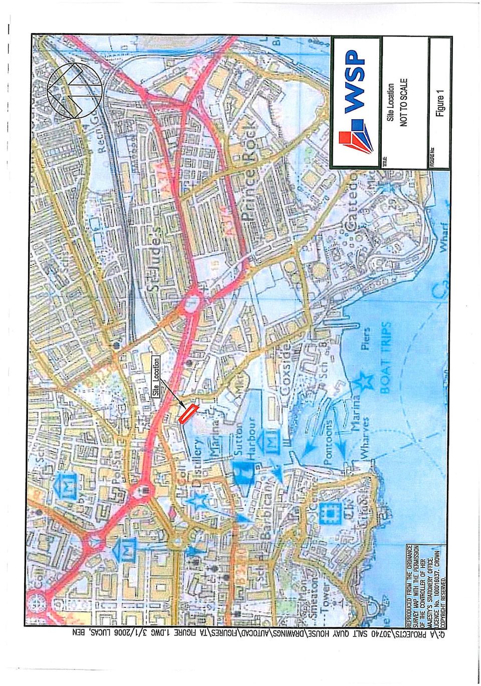
6 2 Existing Land Uses and Existing Flooding Issues %2# 36( The proposed development site is currently known as Salt Quay House, Sutton Harbour in Plymouth and is at NGR SX A location plan can be seen as Figure 1 in Appendix A The site is bounded to the northeast by a builder s merchants whilst to the southwest by the quay and marina. Immediately to the south is The Boatyard site, for which planning permission was secured for a mixed use development late in To the northwest is the existing residential development of North Quay The existing Salt Quay House is a former warehouse building with a long frontage along North East Quay and a rear (northeast) elevation which follows a shallow S curve. It consists of two adjoining structures, the northwest section being of two storeys and the southeast a single storey with inserted mezzanines. It is proposed to demolish this building. %2% The existing site can be regarded as totally impermeable. The front elevation pitched roof currently discharges to outfall pipes through the listed quay structure into the harbour. The rear elevation pitched roof of the building drains to a combined sewer which runs through the builders merchant s yard. %2) 36( The site has been identified as at been at risk from flooding on the Environment Agency s indicative flood maps. A copy of the indicative flood map can be seen on Figure 2 in Appendix A An inspection of the Tidal Still Water Levels (2002) for South West England: Coast and Estuaries indicates that the 1 in 200 year or 0.5% annual probability tidal flood level is 3.68mAOD. A copy of the prediction spreadsheet is attached in Appendix B. %2+ 36( Sutton Harbour and the surrounding area are protected by the Sutton Harbour Flood Defence Scheme. The flood defence gates are owned, maintained and serviced by the EA. The gates are operated by the Sutton Harbour lock keepers The current arrangement for the operation of the flood defence gates will continue. The two pairs of gates have separate hydraulic systems. It would require both sets to fail in the open position for the harbour to be at risk of inundation. There is also a back up generator to cover for the eventuality of a power outage The gates are controlled by a computer controlled alarm system. As soon as the seaward tide level reaches 5.6m above chart datum (2.28mAOD) an alarm is activated and the gates automatically shut. If the gates fail to shut there is a manual override whereby the lock keepers can manually close the flood defence gates In advance of a predicted high tide, the EA also fax a warning to the Sutton Harbour lock keepers. However, in practice, the lock keepers with their tide tables, tide books and barometers know in advance if the automated system is likely to be activated Salt Quay House - Flood Risk Assessment 3

7 2.4.5 The EA currently have a proposed capital works scheme to replace the existing gates which are nearing the end of their operational life with new flood defence gates to keep the 1 in 100 year still water level out of the inner harbour. This will increase the level of protection to the properties behind the defence (NB: the Salt Quay site will have in excess of 1m freeboard in the 1 in 200 year tide event). The risk of the new gates failing in the open position should be less than the risk of the current gates failing, but with all mechanical devices a small but not ignorable risk exists It will be expected that as part of the ongoing operation of the existing and new gates that they are regularly tested and maintained as necessary by the EA. This will be particularly important for the gates to be in good working order in advance of predicted high tides The following analyses have been undertaken to assess the residual flood risk to the proposed development in the event of the defences failing completely and allowing the 1 in 200 year flood into Sutton Harbour Salt Quay House - Flood Risk Assessment 4

8 3 Future Land Uses )2# ( It is proposed to demolish the existing converted warehouse building and redevelop the site by the construction of a new commercial development consisting of office and retail space The proposed development will comprise approximately 30,000 square feet of office accommodation and ground floor retail units over 6 floors with a roof plant room. The footprint of the proposed building follows the line of the existing Salt Quay House generally with cantilevered office floors at upper levels projecting 3m towards the quayside. Construction will comprise of a steel frame and composite floor slabs. The primary entrances to the ground floor retail and office areas will be from the quayside elevation During January 2007, an FRA was prepared for a commercial development on this site with a raised ground slab level some 500mm above the Q 200 flood level. Although this proposal was warmly received by the EA, it was considered unacceptable by Plymouth City Council (PCC) in respect of preventing the delivery of some key aspirations of the Local Plan and Area Action Plan. In planning and urban design terms, PCC are looking for an at grade solution with spill out from the active frontages onto the listed quayside in keeping with both the historic character of the harbour and the more recent developments that surround the inner harbour Copies of the project architect s proposed ground floor plan, section and 3D sketch perspective of the proposed development are included in Appendix A The granite coping edge of the listed harbour wall in front of Salt Quay House has a level of typically 3.50mAOD. The ground floor entrance will be raised nominally to form a ground floor at 3.65mAOD into a reception area serving a ground floor office and access to upper floors. A separate at grade access will also be provided to a retail area facing out to the quayside. Again the proposed ground floor slab level is 3.65mAOD. )2% In the future the site will be covered by the building. Therefore the impermeable areas will remain as at present and accordingly there will be no increase in surface water runoff rates. However the whole roof will drain to the front elevation of the building and discharge into an existing piped outfall through the listed quay wall and into the harbour. This will reduce the runoff from the rear of the existing building which currently discharges to a combined sewer which will accordingly reduce the flood risk in this area Salt Quay House - Flood Risk Assessment 5

9 4 Future Tidal Flooding Issues +2# 55#3%.."5(( ( An inspection of the Tidal Still Water Levels (2002) for South West England: Coast and Estuaries indicates that the 0.5% annual probability or 1 in 200 year return period tidal flood level is 3.68mAOD. A copy of the prediction spreadsheet is attached in Appendix B. +2% 55(! Annex B of PPS25 details the latest research on the issue of climate change. With regard to sea levels paragraph B5 states: Global sea levels will continue to rise, depending on greenhouse gas emissions and the sensitivity of the climate system. The relative sea level rise in England also depends upon vertical movement of the land, which is generally falling in the south-east and rising in the north and west. Allowances for the regional rates of relative sea level rise shown in Table B.1 should be used Table B.1 specifies recommended contingency allowances for net sea level rise in four periods from 1990 to The current EA guidance recommends a design life of 60 years for commercial developments, such as this. Therefore the following calculation has been undertaken to calculate what the 1 in 200 year return period tidal flood level will be in 60 years time, 2067, working from the base level of 3.68mAOD in = mm pa = 80mm = mm pa = 240mm = mm pa = 138mm Total predicted sea level rise from = 458mm +2) 555(( ( By adding together the two above predictions, the future design tidal level can be estimated Using the PPS25 guidance, the 1 in 200 year still water level in 2067 can be calculated as = 4.14mAOD. +2+ ( (4459 (31(" The site has been confirmed by the EA as being Zone 3a as defined by Table D1 of PPS25, i.e. with a high probability of flooding when the presence of flood defences is ignored The proposed development is purely commercial in its nature. Table D2 of PPS25 classifies such developments as being less vulnerable. The EA have confirmed that they will be looking for a 60 year design life for all new commercial developments Taking the output from Tables D1 and D2, Table D3 concludes that such less vulnerable developments are appropriate for Zone 3a. +2* 5(( Should a tidal flood occur, the surge would enter Plymouth Sound around the breakwater, and then into the Tamar and Plym estuaries where it would enter the Outer Salt Quay House - Flood Risk Assessment 6

10 Sutton Harbour before coming up against the lock gates that separates the outer and inner harbours These lock gates would be closed once a flood warning has been given. The outer gate is 12m wide and has a top level of 3.86mAOD whilst the inner gate is 14m wide and has a top level of 2.78mAOD. The tidal defence wall which is adjacent to the lock gates and separates the inner and outer harbours is at a level of 4.03mAOD. +2, 33 14(4457 ( ( To predict the rise in water level of the inner harbour adjacent to the proposed development site, a tidal overtopping analysis flood model was created as part of the Flood Risk Assessment undertaken for the adjacent Boatyard site The model used a three cycle tidal surge with the top of the cycle being equivalent to the predicted tide levels. As the tide rises above the outer lock gates sea water flows into the lock. Once the lock s water level has risen to the inner lock gates level, water spills over into the inner harbour. The analysis was based on the inner harbour impounded still water level being 2.28mAOD, as originally advised by the EA. In more recent correspondence with the EA it has been suggested that the operating regime has been revised and a higher impounded still water level of 2.48mAOD has been adopted, although no written evidence has been supplied to date to support this Using the PPS25 predictions, the defence is overtopped and the water level in the inner harbour is predicted to rise to 2.40mAOD. A summary of the methodology and results are attached in Appendix B The impact of the higher initial impounded water level (2.48mAOD) would be to reduce the amount of storage available for flood water overtopping of the gate. Therefore it is fair to assume that the maximum water level in the harbour if the overtopping analysis were to be rerun would be 200mm higher than shown in Appendix B; i.e mAOD, some 900mm below the existing quay wall level and over 1m below the ground floor slab level of the proposed Salt Quay House development. +2/ As part of the Boatyard FRA we also considered the effect of wave overtopping of the outer gate and wall. Because of the topography of the area, the wave fetches are comparatively short, but some localised wave action can lead to additional overtopping of the gate as witnessed in October However, because of the significant available storage volume in the inner harbour (600mm depth over 93,000m 2 inner harbour plan area = 55,000m 3 ), this is not considered to be a significant risk of additional flooding. (Note the 600mm is the minimum available depth above the impounded water level of 2.40mAOD and the lowest part of the quay wall at the Barbican at 3.0mAOD.) As initially agreed with the EA Development Control Officer for the Boatyard site, it was not considered necessary to calculate the likely volume of water that could overtop the defence given the comparatively huge available storage volume of the inner harbour. However in response to later communication with the EA we made a number of conservative estimates to calculate the likely scale of wave overtopping In Appendix B we have included a single sheet of calculations summarising the effect of potential wave overtopping of the gate and wall defences. We have calculated that a series of 300mm high waves hitting the defences for the duration of the tide being within 300mm the top of the wall results in the harbour filling by approximately 40mm Salt Quay House - Flood Risk Assessment 7

11 Therefore, even with the combined effect of the 1 in 200 year tide, the worst case climate change allowance and wave action, the proposed development still has a freeboard of approximately 1m above the water level in the harbour, providing the gates close It is possible that larger waves will hit the defences, but in these cases only the crest is likely to overtop into the inner harbour. Therefore we have taken a conservative approach in assessing the impact of smaller waves occurring when the 1 in 200 year tide is coincident with the top of the defences and with all of the wave overtopping into the inner harbour If the existing Sutton Harbour Flood Defence Scheme is improved as proposed, then the risk of overtopping will be reduced accordingly. +2: 7 ( South West Water and Plymouth City Council Highways Department have been approached with regard to any flooding caused by their surface water systems. Following discussions both have confirmed that they have no record of surface water or highway flooding in this area, other than minor localised ponding due to leaves blocking road gullies By discharging the whole of the roof drainage into the harbour (at present the rear of the building discharges to a combined sewer), the flows in the sewer and resultant surface water flood risk will be lower Salt Quay House - Flood Risk Assessment 8

12 5 Miscellaneous Issues *2#! 63" As the flood levels are not predicted to raise above the harbour wall, access can be afforded at all states of the tidal cycle along Sutton Road. If the gates fail in the open position when a flood above 3.5mAOD is predicted, the early warning will activate the Flood Management Plan prepared by Sutton Harbour. In this circumstance the emergency access will be from the development to higher land on Sutton Road or Exeter Road. The Flood Management Plan prepared to discharge a planning condition on the Boatyard planning approval can be extended to include this immediately adjacent site. *2% To protect the environment from flooding during the construction period a localised runoff management system will be employed by the main contractor To prevent oils from polluting the environment, all oil stores will be bunded and maintained regularly during the construction period The contractor is to produce a method statement and agree it with the Environment Agency prior to the start of the construction. *2)! The private drainage will be designed to the requirements of the Building Regulations and handed over to the owners for maintenance The main drainage surface water system will be designed to Sewers for Adoption 6 th Ed and will be offered to South West Water for Adoption and future maintenance. *2+ 4( We have contacted South West Water to check whether there is sufficient capacity in the local sewer network. SWW have replied saying that they have no local capacity problems and providing that there are no unusually high discharges, then they would not envisage a problem in accepting the foul flows from the new development. The proposed reduction in discharge of roof drainage to the combined sewer will also increase the local capacity in the combined sewer. *2* 7 (" The rainwater will be collected and directed straight into the underground pipe system. Therefore, it is not envisaged that there will be any residual water quality issues. *2, ( 35";5! Until such time as the hazards relating to the site or location are known, we are unable to confirm that our recommendations or design will be acceptable in terms of safe buildability/maintainability Given the preliminary nature of our proposals and the limitations of our brief, we have not fully sought to obtain nor become aware of any significant information relating to hazards that might affect the construction or maintenance of this project Under the CDM Regulations, adequate information about the site must be provided by the client in order to allow the potential hazards to be reviewed by the designer and avoidance/mitigation measures taken where reasonably practicable Salt Quay House - Flood Risk Assessment 9

13 6 Mitigation Measures and Residual Risks,2#! 643! If the flood defence gates operate as designed, the inner harbour will have in excess of 1m freeboard. The model produced for the adjacent Boatyard site of the tidal inundation for the inner harbour predicted that the future water level will rise by 0.121m to 2.401mAOD The granite coping edge of the harbour wall in front of Salt Quay House has a level of typically 3.50mAOD; therefore, the proposed development will not be flooded during the design event. The finished ground level at the development area is to be 3.65mAOD which is over 1m above the predicted defended 1 in 200 year flood level However, this Flood Risk Assessment considers the residual risk of flooding in the event of both gates failing in the open position. The two pairs of gates have separate hydraulic systems. It would require both sets to fail in the open position for the harbour to be at risk of inundation. There is also a back up generator to cover for the eventuality of a power outage. However if all of these situations arose and the gates couldn t be closed manually (which is the failsafe position), then there is a residual risk of the whole area around Sutton Harbour flooding, and the following are put forward as mitigation measures to address this risk With a design life of 60 years for this proposed commercial development, the Q 200 tidal flood level with 60 years of climate change is = 4.14mAOD The architect has mitigated against the residual flood risk and designed the building with an external envelope constructed of flood resistant materials. Demountable flood defences are also proposed to be provided to the ground floor accesses in line with the proposals for the adjacent Boatyard site. These flood boards will be 1100mm high to provide flood defence up to a water level of 4.75mAOD offering just over 600mm freeboard above the design flood level The Flood Management Plan for the installation of the demountable flood defences for the Boatyard site could be extended to include the ground floor entrances to Salt Quay House. Figure 3 in Appendix A shows the indicative flood boards required to protect the ground floor against the residual flood risk. The exact size and form of these flood boards will be finalised at the detailed design stage In this situation, after receiving the appropriate early warning of a predicted high tide above the ground floor slab level of 3.65mAOD, the flood boards can be installed to protect Salt Quay House It is also proposed that the building is placed on the EA early warning flood risk register in the same way that all properties around Sutton Harbour and the Barbican area should be. However, due to the predictable nature of tidal events, the EA will be able to offer much earlier flood warnings than can be expected for fluvial flooding It is also recommended to raise all electrics for ground floor properties by a minimum of 600mm above floor level The impermeable areas will not increase due to the development and therefore, the surface water runoff will not increase. South West Water has confirmed that they do not have any suitable connections to their surface water network. Therefore, the surface water from the whole roof will discharge into Sutton Harbour using the same points of discharge through the listed quay wall as at present Salt Quay House - Flood Risk Assessment 10

14 ,2% 5(( It is understood that funding has been received by the Environment Agency to carry out works on the flood defence gate and the wall between the inner and outer harbours. This will enhance the protection afforded to the proposed development and the existing properties around the harbour and the historic Barbican area. The latest correspondence from the Environment Agency has confirmed that the current proposal is to raise the level of the existing defence by 170mm. According to the EA, this is intended to offer protection from extreme tidal flooding until The Defra / EA Flood Risk Assessment Guidance for New Development (FD2320/TR2) includes a section on safe access and exit from new developments in flood risk areas. Table 13.1 summarises the danger to people for different combinations of depth and velocity. For the proposed Salt Quay House, the existing listed quayside level is typically 3.5mAOD. The Q 200 flood level with 60 years of predicted sea level rise due to climate change is 4.14mAOD. Therefore we are considering a worst case depth of water of 640mm over the quayside if the flood gates fail in the open position as previously described Although no modelling or analysis of flood flow velocities has been undertaken as part of this FRA, it is reasonable to accept that the velocities will be very low. As a result Table 13.1 concludes that there is a danger for most. However because of the predictable nature of tidal flooding and the placing of the proposed development on the EA s early flood warning system, a safe means of egress can be provided from the development to higher land on Sutton Road and Exeter Road. It must always be borne in mind that this residual risk of flooding can only occur if both of the EA flood defence harbour gates fail in their open position Salt Quay House - Flood Risk Assessment 11

15 7 Conclusions And Recommendations /2# 43( The site is in Zone 3a as defined by Table D1 of PPS25, i.e. with a high probability of flooding when the presence of flood defences is ignored The proposed development is purely commercial in its nature. Table D2 of PPS25 classifies such developments as being less vulnerable. The EA have confirmed that they will be looking for a 60 year design life for all new commercial developments Taking the output from Tables D1 and D2, Table D3 concludes that such less vulnerable developments are appropriate for Zone 3a With a design life of 60 years for this proposed commercial development, the Q 200 tidal flood level with 60 years of climate change is 4.14mAOD. The architect has designed the building to provide level access to the quayside to comply with Plymouth City Council s planning vision for this location In the event of the EA flood defence gates failing, a Flood Management Plan will be activated and the demountable flood defences installed. These 1100mm high flood boards will provide a 600mm freeboard above the design flood level In conclusion it can be seen that the proposed development can be undertaken without increasing the flood risk to itself or adjacent properties. /2% 4!! It is recommended that approval for the scheme is given and that the Environment Agency release a Letter of Conformity to the Local Planning Authority Once planning permission has been obtained, the above outline proposals are reviewed and a detailed design is undertaken. This design must then be reviewed for technical, environmental, health and safety and for CDM compliance Salt Quay House - Flood Risk Assessment 12

16 Appendices - Figures & Calculations

17

18
19

20

21
22
23
24
25
26
27
28
29
30
31
FLOOD RISK ASSESSMENT AND DRAINAGE STRATEGY
 FLOOD RISK ASSESSMENT AND DRAINAGE STRATEGY London Rd. WATERLOOVILE FOR McCarthy & Stone Ltd. July 2010 Such Salinger Peters Ltd 30558-1- Flood Risk Assessment & Drainage Strategy Contents Paragraph Page
Proposed Re-development, At 321 London Road, Wyberton. Flood Risk Assessment - Revised
 Proposed Re-development, At 321 London Road, Wyberton Flood Risk Assessment - Revised Prepared By: C Mason C.Eng M.I.C.E May 2015 Contents Page No. 1. Introduction 2 2. Site Description 2 3. Flood Hazard
Recommendations for future developments
 C Recommendations for future developments C.1 Reducing flood risk through site layout and design C.1.1 C.1.2 Flood risk should be considered at an early stage in deciding the layout and design of a site
FLOOD RISK RECENT TRENDS AND POLICY RESPONSES
 FLOOD RISK RECENT TRENDS AND POLICY RESPONSES DEVELOPING WESTMINSTER S LOCAL PLAN Booklet No. 2 LDF Consultation - CMP Revision November 2013 INTRODUCTION CLLR ROBERT DAVIS Westminster is at risk of flooding
London Borough of Waltham Forest LOCAL FLOOD RISK MANAGEMENT STRATEGY. Summary Document
 LOCAL FLOOD RISK MANAGEMENT STRATEGY Summary Document October 2013 Local Flood Risk Management Strategy Summary 1 Introduction 2 Partner responsibilities 3 What do we know about flooding in the borough?
Newbiggin House Farm,
 Newbiggin House Farm, Near Waberthwaite Flood Investigation Report 32 Flood Event 30/8/2012 Cumbria County Council Version Undertaken by Reviewed by Approved by Date Preliminary Colin Parkes Anthony Lane
Cambridge House, Henry Street, Bath BA1 1UR
 Flood Risk Assessment Cambridge House, Henry Street, Bath BA1 1UR For Full Planning application to BANES Council June 2011 Introduction This report is prepared as requested by B&NES to accompany the planning
WEST LONDON PIPELINE AND STORAGE LIMITED AND UNITED KINGDOM OIL PIPELINES LIMITED
 WEST LONDON PIPELINE AND STORAGE LIMITED AND UNITED KINGDOM OIL PIPELINES LIMITED WLPS BUNCEFIELD REBUILD Flood Risk Assessment Green Lane Hemel Hempstead Hertfordshire HP2 7HZ September 2009 Prepared
Vital Earth Composting Facility Flood Risk and Drainage Statement
 Vital Earth Flood Risk and Drainage Statement Final December 2011 Prepared for Vital Earth Ltd Revision Schedule Flood Risk and Drainage Statement December 2011 Rev Date Details Prepared by Reviewed by
Littleport Co-located Schools
 Littleport Co-located Schools February 2015 Morgan Sindall Littleport Co-located Schools 330763 BNI BSE 003 C P:\Cambridge\Murdoch\EST\PROJECTS\330763 Littleport Co-located Schools\12.0 Documents\12.2
Proposed Construction of Basement Flood Risk Assessment. 35 Edwardes Square London W8 6HH
 Proposed Construction of Basement Flood Risk Assessment 35 Edwardes Square London W8 6HH 1 Introduction This FRA has been carried out in accordance with the National Planning Policy Statement (NPPF), the
Bolton s Flood Risk Management Strategy
 Bolton s Flood Risk Management Strategy www.bolton.gov.uk Public Summary Bolton s Flood Risk Management Strategy Public Summary Introduction Over 5.5 million properties in England and Wales are at risk
INFRASTRUCTURE, FLOOD PROTECTION AND REMEDIATION. Infrastructure Flood Protection Remediation Policies
 INFRASTRUCTURE, FLOOD PROTECTION AND REMEDIATION Infrastructure Flood Protection Remediation Policies DRAFT POOLBEG PLANNING SCHEME 196 FIGURE 9.1: UTILITIES WAYLEAVES Electricity Cables 8m Wayleave for
CITY OF VAUGHAN SCHEDULE O LOT GRADING DESIGN FOR RESIDENTIAL DEVELOPMENT
 Page 1 CITY OF VAUGHAN SCHEDULE O LOT GRADING DESIGN FOR RESIDENTIAL DEVELOPMENT CIVIC CENTRE 2141 MAJOR MACKENZIE DRIVE MAPLE ONTARIO L6A 1T1 905-832-2281 Page 2 SECTION 1 - GENERAL OBJECTIVES To provide
Essex County Council Flood Investigation Report
 Essex County Council Stock City of Chelmsford Rev Date Details Author Checked and Approved By 01 February 2015 Draft report for stakeholder consultation Ed Clarke Flood Investigation Engineer Lucy Shepherd
Mr & Mrs Clarke Proposed Development at The River House, Balderstone Flood Risk Assessment
 Proposed Development at The River House, Balderstone D2192-FRA-01 5 Nov 2015 PSA Design Ltd Consulting Engineers The Old Bank House 6 Berry Lane Longridge Preston PR3 3JA Tel. 01772 786066 Fax. 01772 786265
ITEM 8(a) MANAGEMENT COMMITTTE 2 JUNE 2015
 MANAGEMENT COMMITTTE 2 JUNE 2015") ITEM 8(a) MANAGEMENT COMMITTTE 2 JUNE 2015 APPENDIX Report from Harbour Management Board -1April 2015 Weymouth Harbour Walls Remediation Work Harbour Management Board 1 April 2015 Weymouth Harbour Walls
ITEM 8(a) MANAGEMENT COMMITTTE 2 JUNE 2015 APPENDIX Report from Harbour Management Board -1April 2015 Weymouth Harbour Walls Remediation Work Harbour Management Board 1 April 2015 Weymouth Harbour Walls
Land to the rear of the Black Bull Public House Flood Risk Assessment March 10, 2014 Version 1.0 Ref: RAB 148
 Land to the rear of the Black Bull Public House Flood Risk Assessment March 10, 2014 Ref: RAB 148 Lindsey Phillips Turnbull Tweedale Ltd 61 Oaken Lanes Codsall South Staffordshire WV8 2AW R A B C O N S
Erection of replacement warehouse building and erection of two buildings in connection with builder s merchants
 Plan: O 02/00708/FUL Thames Ward (A) Address: Development: Applicant: London Works, Ripple Road, Barking Erection of replacement warehouse building and erection of two buildings in connection with builder
PREVENTION. City of Orem FLOOD DAMAGE PREVENTION 10-1-1
 City of Orem FLOOD DAMAGE PREVENTION 10-1-1 CHAPTER 10. Article 10-1. Article 10-2. Article 10-3. Article 10-4. Article 10-5. FLOOD DAMAGE PREVENTION Purposes Definitions General Provisions Administration
FLOOD RISK ASSESSMENT
 SEVERN ROAD RESOURCE RECOVERY CENTRE FLOOD RISK ASSESSMENT REF 402.0036.00374 September 2009 Severn Road Resource Recovery Centre Ref: 402-0036-00374 Viridor Waste Management i PPS25 Flood Risk Assessment
East Riding of Yorkshire Council
 East Riding of Yorkshire Council Lead Local Flood Authority Interim Standing Advice Revision A - April 2015 1. Introduction From April 2015 the Lead Local Flood Authority (LLFA) became a statutory consultee
FLOOD INFORMATION SERVICE EXPLANATORY NOTES
 FLOOD INFORMATION SERVICE EXPLANATORY NOTES Part 1 About the flood maps Limitations of the mapping What the maps don t show Where to find more information Definitions of words used to describe flooding.
Control filling, grading, dredging, and other development which may increase erosion or flood damage; and
 ARTICLE 16. FLOOD DAMAGE PREVENTION Section 16-1: Findings of Fact The flood hazard areas of the Town of Lillington are subject to periodic inundation which results in loss of life and property, health
FLOOD RISK AND SURFACE WATER DRAINAGE ASSESSMENT HILLHOUSE RESTORATION SITE, OFF JAMESON ROAD, THORNTON CLEVELEYS ON BEHALF OF NPL ESTATES
 FLOOD RISK AND SURFACE WATER DRAINAGE ASSESSMENT HILLHOUSE RESTORATION SITE, OFF JAMESON ROAD, THORNTON CLEVELEYS ON BEHALF OF NPL ESTATES Integra Consulting Engineers Limited NS / 2543 Fountain House
FINAL SECTION OF COASTAL PROTECTION RIVER DODDER PART 8 PROPOSALS London Bridge and New Bridge
 FINAL SECTION OF COASTAL PROTECTION RIVER DODDER PART 8 PROPOSALS London Bridge and New Bridge Planning and Development Acts 2000-2006 Planning and Development Regulations 2001-2006, Part 8 March 2012
Emergency Spillways (Sediment basins)
") Emergency Spillways (Sediment basins) DRAINAGE CONTROL TECHNIQUE Low Gradient Velocity Control Short-Term Steep Gradient Channel Lining Medium-Long Term Outlet Control Soil Treatment Permanent [1] [1]
Emergency Spillways (Sediment basins) DRAINAGE CONTROL TECHNIQUE Low Gradient Velocity Control Short-Term Steep Gradient Channel Lining Medium-Long Term Outlet Control Soil Treatment Permanent [1] [1]
Product 4 (Detailed Flood Risk) for: Sam Murray (Amey) Site: Land at Kingsnorth Reference: KSL151125 KR79 Date: 30 th November 2015.
 for: Sam Murray (Amey) Site: Land at Kingsnorth Reference: KSL151125 KR79 Date: 30 th November 2015.") Product 4 (Detailed Flood Risk) for: Sam Murray (Amey) Site: Land at Kingsnorth Reference: KSL151125 KR79 Date: 30 th November 2015 Contents Flood Map Confirmation Flood Map Extract Model Output Data Data
Product 4 (Detailed Flood Risk) for: Sam Murray (Amey) Site: Land at Kingsnorth Reference: KSL151125 KR79 Date: 30 th November 2015 Contents Flood Map Confirmation Flood Map Extract Model Output Data Data
Taylor Wimpey UK Ltd. December 2007
 Taylor Wimpey UK Ltd December 2007 QM Issue/revision Issue 1 Revision 1 Revision 2 Revision 3 Remarks Draft For Planning Date 3 August 2007 20 December 2007 Prepared by D Gooding P Barton Signature Checked
28.0 Development Permit Area #2 (Neighbourhood District)
") 28.0 Development Permit Area #2 (Neighbourhood District) Goals and Objectives To provide a guide for infill and new development in the Neighbourhood District. To outline the nature, form and character
28.0 Development Permit Area #2 (Neighbourhood District) Goals and Objectives To provide a guide for infill and new development in the Neighbourhood District. To outline the nature, form and character
2 ND SEPTEMBER 2014. Report of the Bi-Borough Executive Director for Transport and Technical Services
 London Borough of Hammersmith & Fulham COMMUNITY SAFETY, ENVIRONMENT & RESIDENTS SERVICES POLICY & ACCOUNTABILITY COMMITTEE 2 ND SEPTEMBER 2014 SURFACE WATER MANAGEMENT PLAN (SWMP) Report of the Bi-Borough
UPDATED FUNCTIONAL SERVICING and STORMWATER MANAGEMENT REPORT
 TRAFALGAR ENGINEERING LTD. #1-481 Morden Road Oakville Ontario L6K 3W6 UPDATED FUNCTIONAL SERVICING and STORMWATER MANAGEMENT REPORT Fernbrook Homes (Bronte 15) Limited 3059/3047 Lakeshore Road West TOWN
DEVELOPMENT BRIEF FOR LAND AT ALLOA ROAD, TULLIBODY
 DEVELOPMENT BRIEF FOR LAND AT ALLOA ROAD, TULLIBODY 1.0 Introduction and Purpose 1.1 Clackmannanshire Council is seeking to dispose of a site at Alloa Road, Tullibody for redevelopment. The site extends
Norfolk House Hotel Development Gatwick Airport. Flood Risk Statement. May 2012. Bloc Hotels. Vantage Planning Ltd. www.vantageplanning.co.
 Development Gatwick Airport May 2012 Bloc Hotels Vantage Planning Ltd www.vantageplanning.co.uk Vantage Planning Ltd Contents 1. Introduction... 2 2. The Proposed Development... 2 3. The Development Site...
Ward: Purley DELEGATED BUSINESS MEETING Lead Officer: Head of Planning Control week of 23/03/2009
 Ward: Purley DELEGATED BUSINESS MEETING Lead Officer: Head of Planning Control week of 23/03/2009 Application No. 09/00389/LP - 51-61 Whytecliffe Road South, Purley, CR8 1. SUMMARY 1.1 This report concerns
Strategic Flood Risk Assessment
 local development framework Strategic Flood Risk Assessment LOCAL DEVELOPMENT FRAMEWORK ROYAL BOROUGH OF KINGSTON UPON THAMES Level 1 and 2 April 2011 Contents Executive Summary 5 Part 1 - Aiding Planning
Development Management Report
 Committee and Date Central Planning Committee 5 th April 2012 Item 13 Public Development Management Report Responsible Officer: Stuart Thomas email: stuart.thomas@shropshire.gov.uk Tel: 01743 252665 Fax:
Federal Triangle Stormwater Working Group Federal Triangle Floodproofing Seminar BUILDING STRONG SM
 Federal Triangle Stormwater Working Group Federal Triangle Floodproofing Seminar Initial Risk Flood Risk = Probability of Flooding x Consequences Zoning Building Codes Outreach Evacuation Planning Risk
Flood Risk Assessment. For Application at: Brick House Farm Brick House Lane Hambleton Lancashire FY6 9BG
 Flood Risk Assessment For Application at: Brick House Farm Brick House Lane Hambleton Lancashire FY6 9BG Contents 1. Introduction 2. The Site 3. Flood Risk 4. Existing drainage 5. Proposed Development
Preliminary Environmental Information Report: Appendix 16.C. Flood Warning and Evacuation Plan
 Preliminary Environmental Information Report: Appendix 16.C Flood Warning and Evacuation Plan THIS PAGE IS LEFT INTENTIONALLY BLANK Page 2 of 30 Contents SUMMARY 1. INTRODUCTION... 9 1.1 Background...
Vestibule Case Study. Vestibule Requirement Intent [2003 IECC, 2006 IECC, 2003 IBC, 2006 IBC, 90.1-2001, 90.1-2004]
![Vestibule Case Study. Vestibule Requirement Intent [2003 IECC, 2006 IECC, 2003 IBC, 2006 IBC, 90.1-2001, 90.1-2004]](/thumbs/24/2939769.jpg "Vestibule Case Study. Vestibule Requirement Intent [2003 IECC, 2006 IECC, 2003 IBC, 2006 IBC, 90.1-2001, 90.1-2004]") Vestibule Case Study [2003 IECC, 2006 IECC, 2003 IBC, 2006 IBC, 90.1-2001, 90.1-2004] Vestibule Requirement Intent Page 1 of 14 The primary intent behind the requirement for a vestibule is to reduce infiltration
Vestibule Case Study [2003 IECC, 2006 IECC, 2003 IBC, 2006 IBC, 90.1-2001, 90.1-2004] Vestibule Requirement Intent Page 1 of 14 The primary intent behind the requirement for a vestibule is to reduce infiltration
ORDINANCE NO. 2013 -
 ORDINANCE NO. 2013 - AN ORDINANCE OF BREVARD COUNTY, FLORIDA AMENDING CHAPTER 62, LAND DEVELOPMENT REGULATIONS SECTION 62-2891, LOT DRAINAGE, AND CHAPTER 22 BUILDINGS AND BUILDING REGULATIONS, SECTION
London Borough of Merton Local Flood Risk Management Strategy
 Local Flood Risk Management Strategy Summary 2014-2020 Introduction In response to the severe flooding across large parts of England and Wales in summer 2007, the Government has recently enacted the Flood
FLOOD RISKS IN LONDON
 Environment Committee FLOOD RISKS IN LONDON Summary of findings April 2014 About this summary 2 This is a summary of the findings of the Environment Committee s investigation into flood risk. In January
R enfrewshire Local Plan. Safe Environment. Page. Flooding & Sustainable Urban Drainage 163 Contaminated Land 175 Noise 177 Major-Accident Hazards 179
 R enfrewshire Local Plan Safe Environment Page Flooding & Sustainable Urban Drainage 163 Contaminated Land 175 Noise 177 Major-Accident Hazards 179 16 Flooding and Sustainable Urban Drainage OVERVIEW Flooding
FLOOD DAMAGE PREVENTION ORDINANCE
 FLOOD DAMAGE PREVENTION ORDINANCE SECTION 1.0 STATUTORY AUTHORIZATION, FINDINGS FO FACT, PURPOSE, AND OBJECTIVES 1.1 STATUTORY AUTHORIZATION The Legislature of the State of Washington has in RCW delegated
Strategic Flood Risk Assessment Update 2015
 Strategic Flood Risk Assessment Update 2015 On behalf of Contents Glossary... iv Executive Summary... 1 1 Introduction... 4 1.1 Overview... 4 1.2 Future Development in Lewisham Borough... 5 2 SFRA Approach...
Flood Risk Assessment and Drainage Statement
 Trinity College, Cambridge Proposed Relocation of Felixstowe Rifle Range, Land north of Nicholas Road, Trimley St Mary, Felixstowe Quality Assurance Site name: Client name: Proposed Relocation of Felixstowe
Welcome Welcome to the public exhibition for development at Bowman Field. This exhibition provides an overview of the proposals for the site.
 Welcome Welcome to the public exhibition for development at Bowman Field. This exhibition provides an overview of the proposals for the site. Background & Planning Context The Site The site is an area
Action plans for hotspot locations - Ash Study
 Appendix 9 Action plans for hotspot locations - Ash Study Ash Vale North 1. Local evidence indicates the culvert could not discharge during December 2013 because the outlet was blocked on the western side
ART Vulnerability and Risk Assessment Report September 2012 Appendix C. ART GIS Exposure Analysis
 Adapting to Rising Tides GIS Exposure Analysis The aim of this appendix is to familiarize the reader with the data and methodology that was used to conduct an analysis of shoreline and community asset
Building Foundation and Structure
 Building Foundation and Structure Overview The construction of the Hall of Waters building began in 1936, and was constructed over the original site of the Siloam and Sulpho-Saline Springs. The original
1.2 This technical note provides a preliminary investigation into the Flood Risk and provides outline drainage strategies.
 ODYSSEY MARKIDES TECHNICAL NOTE PROJECT : CHAILEY HOUSE, BLEWBURY JOB NO. : 14-216 NOTE TITLE : PRELIMINARY FLOODING AND DRAIANGE AUTHOR : STEVEN ROOTH APPROVED : ANDREAS MARKIDES DATE : 02/09/2014 1.0
NEW DEVELOPMENT AND EMERGENCY FLOOD PLANS
 23 NEW DEVELOPMENT AND EMERGENCY FLOOD PLANS Turn page Northamptonshire Flood Toolkit This guidance has been developed to support applicants and developers who are required or encouraged to produce and
FLOOD RISK STATEMENT IN SUPPORT OF THE CONNECTING HERNE BAY AREA ACTION PLAN PREFERRED OPTIONS DOCUMENT
 FLOOD RISK STATEMENT IN SUPPORT OF THE CONNECTING HERNE BAY AREA ACTION PLAN PREFERRED OPTIONS DOCUMENT Canterbury City Council January 2008 1 APPLICATION OF THE PPS25 SEQUENTIAL AND EXCEPTION TESTS 1.0
Water and Flooding Position Statement
 Derby City Local Plan, Part 1: Core Strategy Water and Flooding Position Statement August 2015 1. Introduction 1.1 This position statement provides an update to the Derby HMA Joint Water Issues Paper which
VALIDATION REQUIREMENTS FOR PLANNING APPLICATIONS
 Planning Services, Civic Offices, New Road, Grays, Essex RM17 6SL VALIDATION REQUIREMENTS FOR PLANNING APPLICATIONS Checklists to ensure prompt validation: Checklist 1 for ALL applications for planning
Objective 4: Enhanced community education, flood awareness and preparedness
 Objective 4: Enhanced community education, flood awareness and preparedness Understanding the extent and full impacts of flooding is essential for planning for potential future pressures on the drainage
Climate Change and Infrastructure Planning Ahead
 Climate Change and Infrastructure Planning Ahead Climate Change and Infrastructure Planning Ahead Infrastructure the physical facilities that support our society, such as buildings, roads, railways, ports
UltraTech International, Inc. Canadian Secondary Containment Requirements
 UltraTech International, Inc. 11542 Davis Creek Court Jacksonville, Florida 32256 Canadian Secondary Containment Requirements The Canadian Council of Ministers of the Environment (CCME) is the major intergovernmental
rescue and relief efforts in the aftermath of flooding, (iii) repair of flood damaged public facilities and utilities, and
 repair of flood damaged public facilities and utilities, and") 1. Purpose (1) It is the purpose of this Ordinance to protect human life, health, and property from flood conditions, to preserve the ability of floodplains to carry and discharge a base flood, and to
1. Purpose (1) It is the purpose of this Ordinance to protect human life, health, and property from flood conditions, to preserve the ability of floodplains to carry and discharge a base flood, and to
Updated Federal Emergency Management Agency Flood Insurance Rate Maps and Zoning Ordinance Update. July 16, 2015 Policy Committee
 Updated Federal Emergency Management Agency Flood Insurance Rate Maps and Zoning Ordinance Update July 16, 2015 Policy Committee FEMA Map Update Costal Analysis and mapping study by FEMA in 2009 Changes
London Borough of Croydon Local Flood Risk Management Strategy
 London Borough of Croydon Local Flood Risk Management Strategy Summary 2014-2020 Introduction In response to the severe flooding across large parts of England and Wales in summer 2007, the Government has
SECTION 15 FLOODPLAIN MANAGEMENT
 SECTION 15 15.1 Purpose Certain areas of the City of Gardiner, Maine, are subject to periodic flooding, causing serious damages to properties within these areas. Relief is available in the form of flood
The site is Lot 1 DP 837271. Survey of this lot and Willarong Road and Koonya Circuit is given in Figure 2.
 Our Ref : NA49913151-019-L02:BCP/bcp Contact: Dr Brett C. Phillips 8 th May 2015 Cardno (NSW/ACT) Pty Ltd ABN 95 001 145 035 The Manager Bunnings Group Limited, c/- C&M Consulting Engineers 1/142 James
The application site is on the edge of flood zones 1 and 2 with flood zone boundary cutting across part of the southern boundary of the site.
 Flood Risk Assessment Erection of Masjid/ Place of Worship, extended car parking following demolition of 11a Grafton Street & boundary treatment Land adjacent 11/ 11a Grafton Street, Preston, PR1 8JB 0723/
CLACKAMAS COUNTY ZONING AND DEVELOPMENT ORDINANCE
 1008 STORM DRAINAGE (3/24/05) 1008.01 PURPOSE To minimize the amount of stormwater runoff resulting from development utilizing nonstructural controls where possible, maintain and improve water quality,
PE21 7JE LEVEL 2 FLOOD RISK ASSESSMENT
 IE14/014/ymc Proposed Marstons Public House Swineshead Road Wyberton Fen Boston Lincolnshire PE21 7JE LEVEL 2 FLOOD RISK ASSESSMENT SUFFOLK: Registered Office: 7 Museum Street Ipswich Suffolk IP1 1HQ T
5.0 OVERVIEW OF FLOOD DAMAGE REDUCTION MEASURES
 5.0 OVERVIEW OF FLOOD DAMAGE REDUCTION MEASURES Flood damage reduction consists of two basic techniques structural and non-structural. Structural methods modify the flood and take the flood away from people
PLANNING APPLICATION: 12/00056/APP
 PLANNING APPLICATION: 12/00056/APP In the event that a recommendation on this planning application is overturned the Committee is reminded of the advice contained on the front page of the agenda for Reports
VEHICLE CROSSOVER INFORMATION PACK
 VEHICLE CROSSOVER INFORMATION PACK CONTENTS Introduction Section A Section B Section C Section D Section E Criteria for approving a vehicle crossover application (Diagrams to demonstrate measurement criteria)
Presentation on Flood Risk Management To Engineers Ireland 12 th February 2014. David Keane Cork County Council
 Presentation on Flood Risk Management To Engineers Ireland 12 th February 2014 David Keane Cork County Council 1 Contents 1. The Power of Water 2. Defenses 3. Flooding & Flood Types 4. Flood Mitigation
Flood Risk Assessment and Drainage Impact Assessment: Planning Guidance for Developers
 Flood Risk Assessment and Drainage Impact Assessment: Planning Guidance for Developers Development and Regeneration Services Glasgow City Council 229 George Street Glasgow G1 1QU May 2011 1. Introduction...-
NOVEMBER 2009 [ISSUE 5]
![NOVEMBER 2009 [ISSUE 5]](/thumbs/28/12834647.jpg "NOVEMBER 2009 [ISSUE 5]") 375 401 BRIGHTON ROAD CROYDON FLOOD RISK ASSESSMENT CLIENT: TRITHING LTD [ISSUE 5] Head Office: Unit 2 York House Edison Park Dorcan Way Swindon Wiltshire SN3 3RB Tel. 01793 619965 Fax. 01793 619967 Email:
375 401 BRIGHTON ROAD CROYDON FLOOD RISK ASSESSMENT CLIENT: TRITHING LTD [ISSUE 5] Head Office: Unit 2 York House Edison Park Dorcan Way Swindon Wiltshire SN3 3RB Tel. 01793 619965 Fax. 01793 619967 Email:
DRAINAGE MANAGEMENT PLAN. HERTFORDSHIRE RESIDUAL WASTE TREATMENT PLANT Hertfordshire County Council
 DRAINAGE MANAGEMENT PLAN HERTFORDSHIRE RESIDUAL WASTE TREATMENT PLANT Hertfordshire County Council EMPLOYER: Veolia Environmental Services (UK) Plc Veolia House 154A Pentonville Road London N1 9PE Copy
Practice Note 2014-62
 Practice Note 2014-62 Documentation Required for Applications for Building Permits Reference to the Building Code of Australia (BCA) in this Practice Note means Volume One and Volume Two of the National
Floodplain Development Land Use Review
 COMMUNITY DEVELOPMENT DEPARTMENT Planning Division P.O. Box 490 333 Broadalbin Street SW Albany, OR 97321 Phone 541-917-7550 Fax 541-791-0150 www.cityofalbany.net Floodplain Development Land Use Review
Groundwater Flooding: a UK Perspective
 Groundwater Flooding: a UK Perspective David Macdonald British Geological Survey Maclean Building Crowmarsh Gifford Wallingford OX10 8BB Tel 01491 838800 NERC All rights reserved Talk outline Definition
SECTION 1.0 STATUTORY AUTHORIZATION AND PURPOSE
 A local law for Flood Damage Prevention as authorized by the New York State Constitution, Article IX, Section 2, and Environmental Conservation Law, Article 36 1.1 FINDINGS SECTION 1.0 STATUTORY AUTHORIZATION
1 in 30 year 1 in 75 year 1 in 100 year 1 in 100 year plus climate change (+30%) 1 in 200 year
 1 in 200 year") Appendix C1 Surface Water Modelling 1 Overview 1.1 The Drain London modelling was designed to analyse the impact of heavy rainfall events across each London borough by assessing flow paths, velocities
Appendix C1 Surface Water Modelling 1 Overview 1.1 The Drain London modelling was designed to analyse the impact of heavy rainfall events across each London borough by assessing flow paths, velocities
LONDON ROAD SEVENOAKS
 WELCOME TO THE BERKELEY HOMES EXHIBITION Train Station Gr anv i ll e Dar tford Road Lo ad Ro nd on ad Ro Eard SITE Th ed riv e ley R oad on R oad A 224 Gord Pem b rok e Roa d Site Location Since the submission
Advice can also be sought from specific specialist officers in the Council.
 Canterbury City Council Validation of Planning Applications Guidance note 2010: Introduction Up to date advice on the validation of planning applications is contained in the CLG Guidance on information
approval of matters specified in conditions; and The Town and Country Planning (Development Management Procedure) (Scotland) Regulations 2013
 (Scotland) Regulations 2013") Application for: planning permission; planning permission in principle; further applications; approval of matters specified in conditions; and mineral workings (if the planning authority do not have a
Application for: planning permission; planning permission in principle; further applications; approval of matters specified in conditions; and mineral workings (if the planning authority do not have a
THE TOWN AND COUNTRY PLANNING ACT 1990 Grant of Planning Permission
 Civic Offices Havant Hampshire PO9 2AX Tel (023)9247 4174 Fax(023)9244 6588 DX50005 Havant www.havant.gov.uk To: ADP Architects Ltd Richmond Court 94 Botley Road Park Gate Southampton, Hants SO311BA For:
Flood Risk & Surface Water Management. Page 1 of 20
 Page 1 of 20 Flood Risk & Surface Water Management Flood Risk & Surface Water Management and the Planning Process Introduction The purpose of this document is to increase awareness of the potential of
KINGSTON TOWN PLANNING SUB-COMMITTEE 23 MARCH 2005. YELLOW BOX STORAGE 163-165, LONDON ROAD AND 50, GORDON ROAD, Application Number: 05/12156
 APPENDIX C KINGSTON TOWN PLANNING SUB-COMMITTEE 23 MARCH 2005 YELLOW BOX STORAGE 163-165, LONDON ROAD AND 50, GORDON ROAD, Application Number: 05/12156 REPORT BY HEAD OF PLANNING AND DEVELOPMENT SUMMARY
8.1.3 General Design Guidelines. The following guidelines shall be used when designing inlets along a street section:
 . Introduction Presented in this chapter are the criteria and methodology for design and evaluation of storm sewer inlets located in Town of Castle Rock. The review of all planning submittals will be based
CITY OF YORBA LINDA P.O. BOX 87014 CALIFORNIA 92885-8714
 CITY OF YORBA LINDA P.O. BOX 87014 CALIFORNIA 92885-8714 BUILDING DIVISION (714) 961-7120 Single Family Residential New Construction, Additions & Alterations Submittal Requirements Required agency approvals
Presentation by Michael Wade. Crown Representative for Insurance at the Cabinet Office of the UK Government. National Flood Conference Washington DC
 Presentation by Michael Wade Crown Representative for Insurance at the Cabinet Office of the UK Government National Flood Conference Washington DC May 2015 Role of the Crown Representative.. Role of the
K M D Hire Services, LONDON ROAD, NANTWICH, CW5 6LU
 Application No: 11/2196N Location: Proposal: Applicant: Expiry Date: K M D Hire Services, LONDON ROAD, NANTWICH, CW5 6LU Extension and New Store Mr Dan Mellor 17-Aug-2011 SUMMARY RECOMMENDATION Approve
Scheme 3: Rehabilitation of Heritage Building and Redevelopment
 Scheme 3: Rehabilitation of Heritage Building and Redevelopment 135 Keefer Street Constructed in 1910 for the Vancouver Gas Company, the building and surrounding site was used primarily by blacksmiths
Report Relating to Incidents of Flooding within the Dollar Catchment
 Joint Position Statement Report Relating to Incidents of Flooding within the Dollar Catchment October 2012 Eric McQuarrie, Scottish Water Stuart Cullen, Clackmannanshire Council TABLE OF CONTENTS 1. INTRODUCTION...
Florida Building Code 2004 SECTION 1009 STAIRWAYS AND HANDRAILS
 Florida Building Code 2004 SECTION 1009 STAIRWAYS AND HANDRAILS 1009.1 Stairway width. The width of stairways shall be determined as specified in Section 1005.1, but such width shall not be less than 44
Sample Flood Damage Prevention Ordinance
 Sample Flood Damage Prevention Ordinance COUNTY OF RABUN STATE OF GEORGIA ORDINANCE AN ORDINANCE ADOPTING FLOOD DAMAGE PREVENTION REGULATIONS OF THE CITY OF CLAYTON, GEORGIA WHEREAS; The Mayor and City
Homes and Environment Scrutiny Committee. (Environment & Transport)
") REPORT TO: REPORT NO: Homes and Environment Scrutiny Committee HHPPE/89/15S DATE: 9 September 2015 LEAD MEMBER: Councillor David A Bithell (Environment & Transport) CONTACT OFFICER: Neil Taunt (Tel: 729734)
REPORT TO: REPORT NO: Homes and Environment Scrutiny Committee HHPPE/89/15S DATE: 9 September 2015 LEAD MEMBER: Councillor David A Bithell (Environment & Transport) CONTACT OFFICER: Neil Taunt (Tel: 729734)
201 WATER STREET FORWARDERS MUSEUM AND VISITORS INFORMATION CENTRE
 STRUCTURAL INSPECTION REPORT DRAFT 201 WATER STREET FORWARDERS MUSEUM AND VISITORS INFORMATION CENTRE TOWN OF PRESCOTT Date: November 2013 GENIVAR No.: 131-20617-00 2611 Queensview Drive, Suite 300, Ottawa,
Appendix C - Risk Assessment: Technical Details. Appendix C - Risk Assessment: Technical Details
 Appendix C - Risk Assessment: Technical Details Page C1 C1 Surface Water Modelling 1. Introduction 1.1 BACKGROUND URS Scott Wilson has constructed 13 TUFLOW hydraulic models across the London Boroughs
K M D Hire Services, LONDON ROAD, NANTWICH, CW5 6LU
 Application No: 11/2196N Location: Proposal: Applicant: Expiry Date: K M D Hire Services, LONDON ROAD, NANTWICH, CW5 6LU Extension and New Store Mr Dan Mellor 17-Aug-2011 SUMMARY RECOMMENDATION Approve
Flooding in London A London Assembly Scrutiny Report Follow up review Submission by Association of British Insurers (revised April 2004)
") Flooding in London A London Assembly Scrutiny Report Follow up review Submission by Association of British Insurers (revised April 2004) 1. The Association of British Insurers (ABI) is the trade association
Flooding in London A London Assembly Scrutiny Report Follow up review Submission by Association of British Insurers (revised April 2004) 1. The Association of British Insurers (ABI) is the trade association
ACO Water Management: Civils + Infrastructure
 ACO Water Management: Civils + Infrastructure Technical data Introduction to The unit provides an aesthetically pleasing solution when linking proprietary conveyance drainage systems to vegetated infiltration