Open Source Software and Open Interoperability Standards at EDINA National Datacentre
|
|
|
- Georgiana Logan
- 8 years ago
- Views:
Transcription
1 Open Source Software and Open Interoperability Standards at EDINA National Datacentre Joe Vernon November 25, 2009 Slide 1 of 18

2 Overview of Presentation Introducing EDINA national datacentre Our thoughts on open source software and open interoperability standards Two case studies: Digimap DIaD (Data Integration & Dissemination) Conclusions Slide 2 of 18
 Conclusions")
3 EDINA National Datacentre A not-for-profit national datacentre for tertiary education since 1995 Based at The University of Edinburgh, Scotland Our mission To enhance the productivity of research, learning and teaching in UK higher and further education. Focus is on services, but also R&D Geo-Services and research team Largest team within EDINA (~35 people) OGC associate member since 1999 Substantial experience handling geospatial data on a large scale Slide 3 of 18
 OGC")
4 Open Source Software EDINA tasked with pioneering research role to enhance academic services through innovation OSS used throughout our production systems: PostgreSQL+PostGIS >450M geographic objects MapServer, GeoServer, TileCache 1.5M Maps/month generated OpenLayers, MapFish OSS highly customisable, freedom to evolve Virtualised environments no licensing restriction per processor cost, greater architectural flexibility But not suitable for all purposes Slide 4 of 18

5 Open Interoperability Standards Many of EDINA s systems implement Open Geospatial Consortium OpenGIS interoperability standards While we do not offer public WFS/WMS services, we do make extensive use of: WMS, WFS, SLD, GLS, KML, GML Through various mapping / data download clients Our subscription services protected by Shibboleth authentication (implementing SAML to provide single sign-on and attribute exchange) and are free at the point of use Slide 5 of 18
 and are free at the")
6 Digimap a case study Slide 6 of 18

7 What is Digimap? An online mapping and data delivery facility Originally built to provide access to Ordnance Survey (GB) maps and data a virtual map library Launched in 2000 first time UK academia had access to this type and quantity of high quality data Subscription service with some 60,000 users Extended to now include hydrographic, geological and historic mapping and data Open standards and protocols heavily deployed by Digimap services underpinned by a mix of both open source and proprietary software Slide 7 of 18

8 Digimap Mapping Facilities Classic / Roam Carto Slide 8 of 18

9 Digimap Architecture Roam OpenLayers Carto Web Apache WMS TileCache MapServer SFSQL WMS Cadcorp software Sept 2009 QuantumGIS Raster data PostgreSQL PostGIS GDAL, OGR June 2009, replaced IngresDB Slide 9 of 18

10 Digimap and MS Live Search compared Aviemore, Scotland Slide 10 of 18

11 DIaD a second case study (Data Integration and Dissemination) Slide 11 of 18
")
12 Data Integration and Dissemination Slide 12 of 18

13 Geographic Linking Service Spec. Slide 13 of 18

14 Open Source Software in DIaD DIaD implemented with Open Source Software: OpenLayers / jquery client UKBORDERS (PostGIS GeoServer WFS) GLS implemented using OGR, outputs ESRI Shapefile Cartogram generation with ScapeToad ( Plan to open source our own GLS code Slide 14 of 18


15 Cartogram generation service Cartograms generated via DIaD Geo-linking service Slide 15 of 18

16 Conclusions (1) Open source software vital for our operation Led our ability to provide robust, scalable services without additional licence costs but Proprietary software necessary for: Plotting A0 maps, additional styling / bitmap symbols GeoPDF with layer support etc Open standards have a definite role, vital for chaining open source products but They are not an end in themselves Not always as mature (or static) as might wish and can evolve in short time periods! Slide 16 of 18
 as might wish and can evolve in short time periods!")
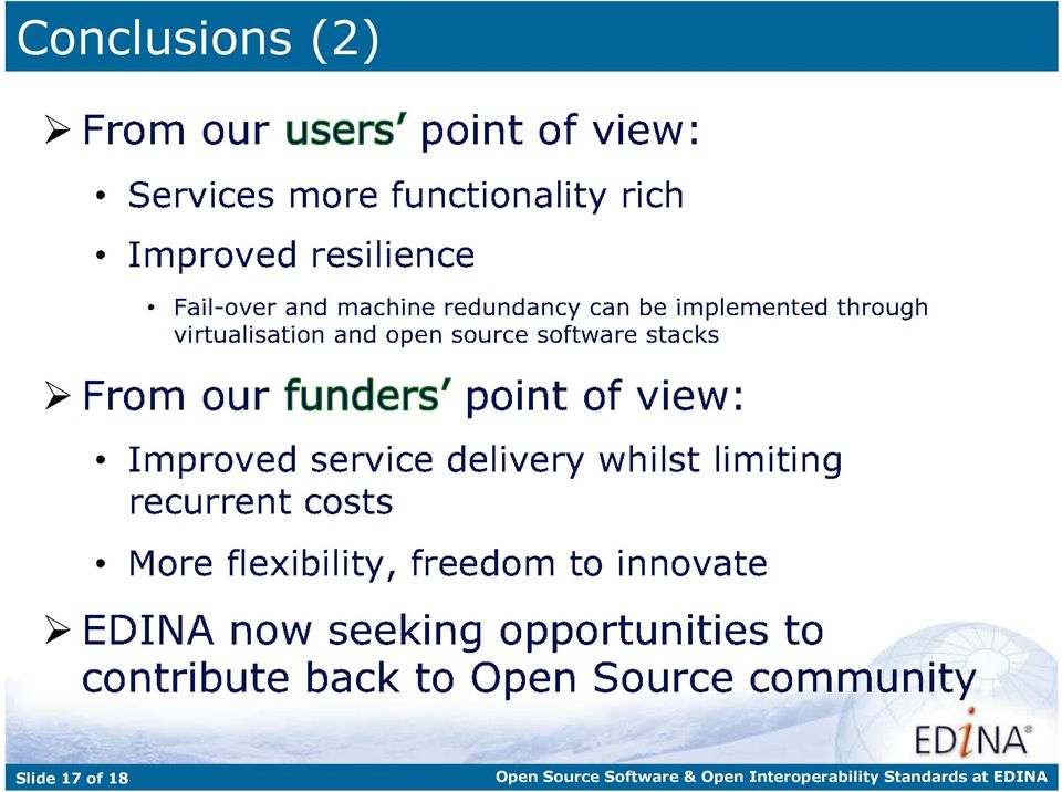
17 Conclusions (2) Slide 17 of 18
18 Thank you Any Questions? Joe Vernon EDINA website: Case Studies Digimap: DIaD: Slide 18 of 18

Institute of Computational Modeling SB RAS
 Institute of Computational Modeling SB RAS ORGANIZATION OF ACCESS TO OBSERVATIONAL DATA USING WEB SERVICES FOR MONITORING SYSTEMS THE STATE OF THE ENVIRONMENT Kadochnikov Aleksey A. Russia, Krasnoyarsk
SDI National to Global: perspectives from the UK academic sector
 SDI National to Global: perspectives from the UK academic sector Conor G. Smyth, PhD, FRGS, CGeog. (GIS) conor.smyth@ed.ac.uk EDINA, The University of Edinburgh, Scotland Keywords: academic SDI; geospatial
MapServer and OGC Standards in real life (and saving real lives) Daniel Morissette, Mapgears dmorissette@mapgears.com
 Daniel Morissette, Mapgears dmorissette@mapgears.com") MapServer and OGC Standards in real life (and saving real lives) Daniel Morissette, Mapgears dmorissette@mapgears.com 1 Mapgears Team of MapServer experts (we're the developers) assisting application developers
MapServer and OGC Standards in real life (and saving real lives) Daniel Morissette, Mapgears dmorissette@mapgears.com 1 Mapgears Team of MapServer experts (we're the developers) assisting application developers
Oklahoma s Open Source Spatial Data Clearinghouse: OKMaps
 Oklahoma s Open Source Spatial Data Clearinghouse: OKMaps Presented by: Mike Sharp State Geographic Information Coordinator Oklahoma Office of Geographic Information MAGIC 2014 Symposium April 28-May1,
UK Location Programme
 Location Information Interoperability Board Data Publisher How To Guide Understand the background to establishing an INSPIRE View Service using GeoServer DOCUMENT CONTROL Change Summary Version Date Author/Editor
Open Source GIS The Future?
 Open Source GIS The Future? Daniel Morissette DM Solutions Group Inc. Open Source Licensing No licensing costs Unlimited rights to: Use the software View and analyse the source Copy, reuse in other systems
Choosing the right GIS framework for an informed Enterprise Web GIS Solution
 13 ANNUAL INTERNATIONAL CONFERENCE AND EXHIBITION ON GEOSPATIAL INFORMATION TECHNOLOGY AND APPLICATIONS Epicentre; Gurgaon, India; 19-21 January, 2010 Choosing the right GIS framework for an informed Enterprise
OSGeo Web Mapping Typification: GeoMajas, Mapbender, MapFish and OpenLayers. Christoph Baudson Arnulf Christl FOSS4G 2010 Barcelona
 OSGeo Web Mapping Typification: GeoMajas, Mapbender, MapFish and OpenLayers Christoph Baudson Arnulf Christl FOSS4G 2010 Barcelona Disclaimer All information contained in this presentation has been compiled
Green Move Web Viewer: critical issues and implementation
 GIT Geology and Information Technology 8a Riunione del Gruppo di Geologia informatica Sezione della Società Geologica Italiana Chiavenna, 17-19 giugno 2013 Polo Territoriale di Como Laboratorio di Geomatica
Combining Drupal Content Management System with OGC Web Services
 Combining Drupal Content Management System with OGC Web Services By Terefe Hanchiso Sodango (Haramaya University, Ethiopia) Dr. U.D. (Ulanbek) Turdukulov & Drs. B.J. (Barend) Köbben(University of Twente,
Cloud application for water resources modeling. Faculty of Computer Science, University Goce Delcev Shtip, Republic of Macedonia
 Cloud application for water resources modeling Assist. Prof. Dr. Blagoj Delipetrev 1, Assist. Prof. Dr. Marjan Delipetrev 2 1 Faculty of Computer Science, University Goce Delcev Shtip, Republic of Macedonia
County of Los Angeles. Chief Information Office Preferred Technologies for Geographic Information Systems (GIS) September 2014
 September 2014") County of Los Angeles Chief Information Office Preferred Technologies for Geographic Information Systems (GIS) September 2014 CIO Preferred Technologies for GIS This document lists the preferred Geographic
County of Los Angeles Chief Information Office Preferred Technologies for Geographic Information Systems (GIS) September 2014 CIO Preferred Technologies for GIS This document lists the preferred Geographic
Data Visualization Using Web GIS Software
 Data Visualization Using Web GIS Software Tuomas Peltonen Radiation and Nuclear Safety Authority (STUK), Finland NKS NordDSS Workshop, Copenhagen, 1.-2.10.2009 RADIATION AND NUCLEAR SAFETY AUTHORITY Preface
Web Mapping in Archaeology
 Non-invasive methods in the contemporary archaeological practice 25th February 2014 http://www.pborycki.pl/pdf/webmapping.pdf Plan of the presentation 1 Web Mapping General Idea History of Web Mapping
Implementation of information system to respond to a nuclear emergency affecting agriculture and food products - Case of Morocco
 Centre National de l énergie des sciences et techniques nucléaires (CNESTEN-Morocco) Implementation of information system to respond to a nuclear emergency affecting agriculture and food products - Case
ARCHITECTURE OF INTEGRATED GIS AND GPS FOR VEHICLE MONITORING
 1 st Logistics International Conference Belgrade, Serbia 28-30 November 2013 ARCHITECTURE OF INTEGRATED GIS AND GPS FOR VEHICLE MONITORING Adela B. Crnišanin * State University of Novi Pazar, Department
GeoPackage, The Shapefile Of The Future
 FOSS4G 2013 GeoPackage, The Shapefile Of The Future @PirminKalberer Sourcepole AG, Switzerland www.sourcepole.com About Sourcepole > QGIS > Core dev. & Project Steering Commitee > QGIS Server, Printing,
From Geoportal to Spatial Data Service Platform. Jani Kylmäaho National Land Survey of Finland Development Centre
 From Geoportal to Spatial Data Service Platform Jani Kylmäaho National Land Survey of Finland Development Centre 29.6.2012 Introduction National Land Survey of Finland - 1900 employees Development Centre
The ORIENTGATE data platform
 Seminar on Proposed and Revised set of indicators June 4-5, 2014 - Belgrade (Serbia) The ORIENTGATE data platform WP2, Action 2.4 Alessandra Nuzzo, Sandro Fiore, Giovanni Aloisio Scientific Computing and
Web and Mobile GIS Applications Development
 Web and Mobile GIS Applications Development Presented by : Aamir Ali Manager Section Head (GIS Software Customization) Pakistan Space and Upper Atmosphere Research Commission (SUPARCO) Geographical Information
Analysis of the Free GIS Software Applications in respect to INSPIRE services and OGC standards
 Analysis of the Free GIS Software Applications in respect to INSPIRE services and OGC standards Authors: Francesco D'Alesio Peter Hopfgartner Paolo Viskanic June 2011 Executive Summary This document analyses
Introduction to the Mapbender OWS Security Proxy
 Introduction to the Mapbender OWS Security Proxy Arnulf Christl, WhereGroup GmbH & Co. KG, Bonn, Germany 1/16 Agenda 1 Introduction to the Architecture OWS from Bottom Up with the OSGeo SDI Software Stack
G-Cloud Service Definition Cadcorp Web Map Layers
 G-Cloud Service Definition Cadcorp Web Map Layers Ref: RM1557/iii Government Procurement Services G-Cloud III Contents 1. Introduction... 3 2. Service Overview... 4 2.1 Web Map Layers... 4 2.2 Initial
GEOENGINE MSc in Geomatics Engineering, Master Thesis Gina Campuzano
 Master Thesis Gina CAMPUZANO Gina Campuzano Development of a GIS web application as a tool for learning of environmental protection -Comparison between MapServer and GeoServer constructing a tool for not
National Geothermal Data System and Global Geosciences Data Integration
 National Geothermal Data System and Global Geosciences Data Integration Lee Allison, AZGS Stephen Richard, AZGS Arlene Anderson, US DOE David Cuyler, US DOE & Sandia Natl Lab NERC 2008 Outline Rational
Standardized data sharing through an open-source Spatial Data Infrastructure: the Afromaison project
 Standardized data sharing through an open-source Spatial Data Infrastructure: the Afromaison project Yaniss Guigoz - University of Geneva/GRID-Geneva 1 EcoARM2ERA and AFROMAISON Why Afromaison in this
Neues vom QGIS Server und QGIS-Webclient
 FOSSGIS 2012 Neues vom QGIS Server und QGIS-Webclient Pirmin Kalberer Sourcepole AG, Pfäffikon SZ www.sourcepole.ch Über Sourcepole > QGIS > Core dev. & Project Steering Commitee > Printing, QGIS Server,
INSPIRE in practice: Experiences with INSPIRE data and services
 INSPIRE in practice: Experiences with INSPIRE data and services Peter Parslow Principal Geographic Information Architect June 2014: ISO TC211 Standards in Practice workshop What s INSPIRE? European Commission
Interoperable Solutions in Web-based Mapping
 ISPRS SIPT IGU UCI CIG ACSG Table of contents Table des matières Authors index Index des auteurs Search Recherches Exit Sortir Interoperable Solutions in Web-based Mapping Marta Wojnarowska and Bridget
Correspondence can be sent to: GeoConnections Natural Resources Canada 615 Booth Street Ottawa, Ontario K1A 0E9
 Quick Guide for CGDI Service Compliance Testing and Performance Optimization May 12, 2009 Correspondence can be sent to: GeoConnections Natural Resources Canada 615 Booth Street Ottawa, Ontario K1A 0E9
Environment Canada Data Management Program. Paul Paciorek Corporate Services Branch May 7, 2014
 Environment Canada Data Management Program Paul Paciorek Corporate Services Branch May 7, 2014 EC Data Management Program (ECDMP) consists of 5 foundational, incremental projects which will implement
Web 3D Service (W3DS) in Geoserver
 in Geoserver") Jorge Gustavo Rocha jgr@di.uminho.pt Nuno Carvalho Oliveira nmco51845@gmail.com VI Jornadas SIG Libre, Girona, March 23, 2012 1 Motivation and Introduction 2 3 4 5 Motivation Motivation and Introduction
Jorge Gustavo Rocha jgr@di.uminho.pt Nuno Carvalho Oliveira nmco51845@gmail.com VI Jornadas SIG Libre, Girona, March 23, 2012 1 Motivation and Introduction 2 3 4 5 Motivation Motivation and Introduction
Delivery of Geo-services at the EDINA National Data Centre: past, present and future
 Delivery of Geo-services at the EDINA National Data Centre: past, present and future Dr David Medyckyj-Scott Research and Geo-data Services Manager EDINA National Data Centre Scotland NMCA s and the Internet
WCS as Candidate INSPIRE Download Service for Coverage Data
 WCS as Candidate INSPIRE Download Service for Coverage Data Alexander Kotsev www.jrc.ec.europa.eu Serving society Stimulating innovation Supporting legislation Context NS Regulation defines two types of
WEB MAPPING WITH DRUPAL Ranel O. Padon
 WEB MAPPING WITH DRUPAL Ranel O. Padon WHY WEB? connectivity & interaction WHY CMS? WHY CMS? WHY CMS? WHY CMS? WHY CMS? WHY PHP? used by almost 30 Million websites around the world. http://trends.builtwith.com/framework/php
Introduction to OSGeo and QGIS
 Introduction to OSGeo and QGIS Arnulf Christl OSGeo President Emeritus ESTGIS Pühajärve, Estonia Arnulf Christl Geospatial Systems Architect OSGeo President Emeritus Director of the metaspatial Institute
OSM GB. Introduction. Users Requirements. Abstract OSM GB
 OSM GB Using Open Source Geospatial Tools to Create OSM Web Services for Great Britain by Amir Pourabdollah University of Nottingham, United Kingdom. amir.pourabdollah@nottingham.ac.uk Abstract A use case
An Introduction to Open Source Geospatial Tools
 An Introduction to Open Source Geospatial Tools by Tyler Mitchell, author of Web Mapping Illustrated GRSS would like to thank Mr. Mitchell for this tutorial. Geospatial technologies come in many forms,
Developing of A GIS Based Enviromental Monitoring System with Open Source Softwares
 L. Kottyán, G. Nagy, A. Szepes Developing of A GIS Based Enviromental Monitoring System with Open Source Softwares Developing of A GIS Based Enviromental Monitoring System with Open Source Softwares László
GIS AS A DECISION SUPPORT FOR SUPPLY CHAIN MANAGEMENT
 Paper Reference No.: PN-253 GIS AS A DECISION SUPPORT FOR SUPPLY CHAIN MANAGEMENT Sanjay Kumar 1 and Suneeta Agrawal 2 1. M. Tech. (GIS & Remote Sensing); GIS Cell; MNNIT, Allahabad, India (E-mail: saj.mnnit@gmail.com)
OPEN STANDARD WEB SERVICES FOR VISUALISATION OF TIME SERIES DATA OF FLOOD MODELS
 OPEN STANDARD WEB SERVICES FOR VISUALISATION OF TIME SERIES DATA OF FLOOD MODELS Barend Köbben FRMRC RPA 7 Workshop visualisations and flow simulations as flood risk communication tools
A Web services solution for Work Management Operations. Venu Kanaparthy Dr. Charles O Hara, Ph. D. Abstract
 A Web services solution for Work Management Operations Venu Kanaparthy Dr. Charles O Hara, Ph. D Abstract The GeoResources Institute at Mississippi State University is leveraging Spatial Technologies and
Open Source GIS. Open Source GIS. Agenda. Open Source. Typische GIS Funktionen. LOTS Bern 18.2.05
 Agenda LOTS Bern 18.2.05 Pirmin Kalberer Sourcepole AG, Bad Ragaz www.sourcepole.ch Typische GIS Anwendungen Datenformate und GIS-Datenbanken Standards & Protokolle Bibliotheken & Applikationen Fragen
Open Source tools for geospatial tasks
 Open Source tools for geospatial tasks Some alternatives to commercial software packages (ricardd@mathstat.dal.ca) Graduate Student Department of Biology Dalhousie University Workshop on Inshore Ecosystems
Chapter 6: Data Acquisition Methods, Procedures, and Issues
 Chapter 6: Data Acquisition Methods, Procedures, and Issues In this Exercise: Data Acquisition Downloading Geographic Data Accessing Data Via Web Map Service Using Data from a Text File or Spreadsheet
VISUAL INSPECTION OF EO DATA AND PRODUCTS - OVERVIEW
 WMS services from the EUMETSAT real-time Image Gallery Uwe Voges (1), Michael Schick (2), Udo Einspanier (1) (1) con terra GmbH Martin-Luther-King-Weg 24, 48155, Münster, Germany EMail: (U.Voges U.Einspanier)@conterra.de
CLOUD BASED N-DIMENSIONAL WEATHER FORECAST VISUALIZATION TOOL WITH IMAGE ANALYSIS CAPABILITIES
 CLOUD BASED N-DIMENSIONAL WEATHER FORECAST VISUALIZATION TOOL WITH IMAGE ANALYSIS CAPABILITIES M. Laka-Iñurrategi a, I. Alberdi a, K. Alonso b, M. Quartulli a a Vicomteh-IK4, Mikeletegi pasealekua 57,
Adoption of open source GIS in South Africa: some case studies
 Adoption of open source GIS in South Africa: some case studies by Gavin Fleming, Kartoza and OSGeo Abstract A number of companies and government departments in South Africa have adopted or migrated to
Managing a Geographic Database From Mobile Devices Through OGC Web Services
 Managing a Geographic Database From Mobile Devices Through OGC Web Services Nieves R. Brisaboa 1, Miguel R. Luaces 1, Jose R. Parama 1, and Jose R. Viqueira 2 1 Database Laboratory, University of A Coruña,
The OSGeo Foundation. FOSS4G Korea 2011 Seoul. Professionally leveraging Open Source Geospatial. Arnulf Christl President
 The OSGeo Foundation Professionally leveraging Open Source Geospatial Arnulf Christl President FOSS4G Korea 2011 Seoul Arnulf Christl Works as Geospatial Systems Architect in his company metaspatial. President
Enabling embedded maps
 Enabling embedded maps Case: National geoportal of Finland Antti Rainio National Land Survey of Finland Trends: Web Services, Mapping Mashup, Open Source, Open Data Decentralised data s Service interfaces
Cloud-based Infrastructures. Serving INSPIRE needs
 Cloud-based Infrastructures Serving INSPIRE needs INSPIRE Conference 2014 Workshop Sessions Benoit BAURENS, AKKA Technologies (F) Claudio LUCCHESE, CNR (I) June 16th, 2014 This content by the InGeoCloudS
ArcGIS Online School Locator
 ArcGIS Online School Locator G-Cloud Services RM 1557vi Service Definition Esri UK G-Cloud 6 Lot 3 SaaS Services Crown Commercial Service Acknowledgement Esri and ArcGIS are trademarks, registered trademarks,
Web Mapping and Geospatial Web: An Introductory Course for Geographers and Geoscientists
 Web Mapping and Geospatial Web: An Introductory Course for Geographers and Geoscientists Emmanuel Stefanakis Department of Geodesy and Geomatics Engineering University of New Brunswick Fredericton, NB,
Investigating Hadoop for Large Spatiotemporal Processing Tasks
 Investigating Hadoop for Large Spatiotemporal Processing Tasks David Strohschein dstrohschein@cga.harvard.edu Stephen Mcdonald stephenmcdonald@cga.harvard.edu Benjamin Lewis blewis@cga.harvard.edu Weihe
EUMETSAT EO Portal. End User Image Access using OGC WMS/WCS services. EUM/OPS/VWG/10/0095 Issue <1> <14/01/2010> Slide: 1
 EUMETSAT EO Portal End User Image Access using OGC WMS/WCS services Slide: 1 Overview Introduction: status of data access and visualization EUMETSAT datasets Architecture Web Map Service implementation
 Development tools to create Web-GIS applications DbMAP ASJ the best solution to easily publish GIS data from existing spatial databases and distributed GIS data sources Easily designs, produces, and publishes
WP 3. Elaboration database Architecture Features (Software Architecture Document)
") Architecture Features (Software Architecture Document) o Best in class solution, using EC recommendations for IT in this field o Implementation based on free open source o Based on OGC standards, high
Architecture Features (Software Architecture Document) o Best in class solution, using EC recommendations for IT in this field o Implementation based on free open source o Based on OGC standards, high
Open Source Geospatial Software. Bob Bruce, P.Eng Mapping and Lands Branch, Manitoba Conservation WWW.HWPS.CA Bob.Bruce@gov.mb.ca
 A Survey of Open Source Geospatial Software Bob Bruce, P.Eng Mapping and Lands Branch, Manitoba Conservation WWW.HWPS.CA Bob.Bruce@gov.mb.ca APEGM PD Breakfast Tuesday, 12 June 2007 access this presentation
Treading Into Open Source GIS
 Treading Into Open Source GIS 49th Annual Alaska Surveying & Mapping Conference February 18 th, 2015 David Howes, Ph.D. - David Howes, LLC dhowes.com Jason Pardy - NewfoundGEO Consulting newfoundgeo.com
WP6. e-soter Web Services: Status and Way Ahead to a Global Soil Information Service Yusuf YIGINI EU Joint Research Centre
 e-soter Regional pilot platform as EU contribution to a Global Soil Observing System WP6. e-soter Web Services: Status and Way Ahead to a Global Soil Information Service Yusuf YIGINI EU Joint Research
FreeGIS.net, INSPIRE, Open Source Software and OGC standards
 FreeGIS.net, INSPIRE, Open Source Software and OGC standards Workshop: How Open Source / Free Software and Open Standards complement each other in an SDI environment SFScon 13 Free Software Conference
Arches: An Open Source GIS for the Inventory and Management of Immovable Cultural Heritage
 Arches: An Open Source GIS for the Inventory and Management of Immovable Cultural Heritage David Myers 1, Alison Dalgity 1, Ioannis Avramides 2, and Dennis Wuthrich 3 1 The Getty Conservation Institute,
OGC + Open Source: The keys for the Colombian National Geographic Institute Agustin Coddazzi development of Shared Geographic Services
 OGC + Open Source: The keys for the Colombian National Geographic Institute Agustin Coddazzi development of Shared Geographic Services Alexander Mogollón-Díaz 1, Lilia Patricia Arias 2, F. Javier Zarazaga-Soria
Web Map Service Architecture for Topographic Data in Finland
 Web Map Service Architecture for Topographic Data in Finland Teemu Sipilä National Land Survey of Finland Abstract. Since 2012 National Land Survey of Finland has been renewing its web map services and
PostGIS Data Integration
 PostGIS Data Integration & Display on SIS Alex Hill GIS Manager Contents Plus Dane Group who we are PostGIS Data Integration and Display on SIS What is a Spatial Database? What is PostgreSQL/PostGIS? Why
CentropeSTATISTICS a Tool for Cross-Border Data Presentation Manfred Schrenk, Clemens Beyer, Norbert Ströbinger
 Manfred Schrenk, Clemens Beyer, Norbert Ströbinger (Dipl.-Ing. Manfred Schrenk, Multimediaplan.at, 2320 Schwechat, Austria, schrenk@multimediaplan.at) (Dipl.-Ing. Clemens Beyer, CORP Competence Center
SDI Workshop ESDIN Best Practices. 2011-06-28 INSPIRE conference, Edinburgh. Arnulf Christl, Metaspatial
 SDI Workshop ESDIN Best Practices 2011-06-28 INSPIRE conference, Edinburgh Arnulf Christl, Metaspatial Download this slide set as ODP (1.2MB) or PDF (1.1MB) at http://arnulf.us/publications Arnulf Christl
DESIGN SECURITY AND GEO-RIGHTS MANAGEMENT SERVICES IN SPATIAL DATA INFRASTRUCTURE
 DESIGN SECURITY AND GEO-RIGHTS MANAGEMENT SERVICES IN SPATIAL DATA INFRASTRUCTURE Tomasz Kubik 1, Witold Paluszyński 1, Bartosz Kopańczyk 2, Adam Iwaniak 3, Paweł Netzel 4 1 Institute of Computer Engineering,
GeoKettle: A powerful open source spatial ETL tool
 GeoKettle: A powerful open source spatial ETL tool FOSS4G 2010 Dr. Thierry Badard, CTO Spatialytics inc. Quebec, Canada tbadard@spatialytics.com Barcelona, Spain Sept 9th, 2010 What is GeoKettle? It is
DEVELOPMENT AND COMPARISON OF OPEN SOURCE BASED WEB GIS FRAMEWORKS ON WAMP AND APACHE TOMCAT WEB SERVERS
 DEVELOPMENT AND COMPARISON OF OPEN SOURCE BASED WEB GIS FRAMEWORKS ON WAMP AND APACHE TOMCAT WEB SERVERS Sonam Agrawal a, Rajan Dev Gupta b a GIS Cell, Motilal Nehru National Institute of Technology, Allahabad-211004,
Leveraging Big Data Technologies to Support Research in Unstructured Data Analytics
 Leveraging Big Data Technologies to Support Research in Unstructured Data Analytics BY FRANÇOYS LABONTÉ GENERAL MANAGER JUNE 16, 2015 Principal partenaire financier WWW.CRIM.CA ABOUT CRIM Applied research
Open Source GIS Blitz!
 Open Source GIS Blitz! Startwiththisvideo http://vimeo.com/2598878 Openstreetmap.org Crown copyright no expiration all government map data in England. Rest of Europe not much better Volunteer mapping effort.
Building a Spatial Database in PostgreSQL
 Building a Spatial Database in PostgreSQL David Blasby Refractions Research dblasby@refractions.net http://postgis.refractions.net Introduction PostGIS is a spatial extension for PostgreSQL PostGIS aims
Quality Assessment for Geographic Web Services. Pedro Medeiros (1)
") Quality Assessment for Geographic Web Services Pedro Medeiros (1) (1) IST / INESC-ID, Av. Prof. Dr. Aníbal Cavaco Silva, 2744-016 Porto Salvo, pmelo.medeiros@gmail.com Abstract Being able to assess the
Quality Assessment for Geographic Web Services Pedro Medeiros (1) (1) IST / INESC-ID, Av. Prof. Dr. Aníbal Cavaco Silva, 2744-016 Porto Salvo, pmelo.medeiros@gmail.com Abstract Being able to assess the
GeoMedia Product Update. Title of Presentation. Lorilie Barteski October 15, 2008 Edmonton, AB
 Product Update Title of Presentation Lorilie Barteski Edmonton, AB Know the audience poll Existing /Pro users Version 6.1 Version 6.0 Version 5.2 or earlier Existing WebMap users Version 6.1 Version 6.0
Enterprise GIS Solutions to GIS Data Dissemination
 Enterprise GIS Solutions to GIS Data Dissemination ESRI International User Conference July 13 17, 2009 Wendy M. Turner Senior GIS Engineer & Program Manager Freedom Consulting Group, LLC Building the Enterprise
smespire - Exercises for the Hands-on Training on INSPIRE Network Services April 2014 Jacxsens Paul SADL KU Leuven
 smespire - Exercises for the Hands-on Training on INSPIRE Network Services April 2014 Jacxsens Paul SADL KU Leuven These exercises aim at people who already have some basic knowledge of INSPIRE Network
Institute of Natural Resources Departament of General Geology and Land use planning Work with a MAPS
 Institute of Natural Resources Departament of General Geology and Land use planning Work with a MAPS Lecturers: Berchuk V.Y. Gutareva N.Y. Contents: 1. Qgis; 2. General information; 3. Qgis desktop; 4.
Geographic Web Application
 University of L Aquila Department of Electrical and Information Engineering Geographic Web Application Enrico Ippoliti Building complete web applications This section discuss how to build complete web
DISMAR implementing an OpenGIS compliant Marine Information Management System
 DISMAR implementing an OpenGIS compliant Marine Information Management System Éamonn Ó T uama, Coastal & Marine Resources Centre, ERI, University College Cork. DISMAR DISMAR (Data Integration System for
Open Source Alternatives to Commercial GIS Tools
 UW-Milwaukee GIS Day November 17 th Open Source Alternatives to Commercial GIS Tools James Beaudoin Applied Population Laboratory, University of Wisconsin-Madison Applied Population Laboratory Department
Study of GML-Based Geographical Data Visualization Strategy
 Study of GML-Based Geographical Data Visualization Strategy ZHANG LIN 1, CHEN SHI-BIN 2 1 College of Information Technology, ZheJiang University of Finance & Economics, HangZhou 310012, China 2 College
HANDS-ON WORKSHOP TOOLS FOR SPATIAL DATA VISUALIZATION: Using selected Open Source tools and Open Data to visualize your own spatial data
 HANDS-ON WORKSHOP TOOLS FOR SPATIAL DATA VISUALIZATION: Using selected Open Source tools and Open Data to visualize your own spatial data Barend Köbben Version 1.0 December 12, 2012 Contents 1 Open Data:
ArcGIS. Server. A Complete and Integrated Server GIS
 ArcGIS Server A Complete and Integrated Server GIS ArcGIS Server A Complete and Integrated Server GIS ArcGIS Server enables you to distribute maps, models, and tools to others within your organization
How To Use The Alabama Data Portal
 113 The Alabama Metadata Portal: http://portal.gsa.state.al.us By Philip T. Patterson Geological Survey of Alabama 420 Hackberry Lane P.O. Box 869999 Tuscaloosa, AL 35468-6999 Telephone: (205) 247-3611
GeoServer, The Open Source Solution for the interoperable management of geospatial data
 GeoServer, The Open Source Solution for the interoperable management of geospatial data Ing. Andrea Aime, GeoSolutions Ing. Simone Giannecchini, GeoSolutions Founded in Italy in late 2006 Expertise GeoSolutions
Chaining Façades: Higher Efficiency in evolution-enabled Spatial Data Infrastructures (SDI)
") Chaining Façades: Higher Efficiency in evolution-enabled Spatial Data Infrastructures (SDI) Roland M. Wagner Fraunhofer ISST, Berlin/Dortmund, Germany ABSTRACT After the first publication of the known
Chaining Façades: Higher Efficiency in evolution-enabled Spatial Data Infrastructures (SDI) Roland M. Wagner Fraunhofer ISST, Berlin/Dortmund, Germany ABSTRACT After the first publication of the known
Technical TesT MeThodology JANUAry 2015
 Technical Test Methodology JANUary 2015 DELIVERABLE Project Acronym: SDI4Apps Grant Agreement number: 621129 Project Full Title: Uptake of Open Geographic Information Through Innovative Services Based
Portal for ArcGIS. Satish Sankaran Robert Kircher
 Portal for ArcGIS Satish Sankaran Robert Kircher ArcGIS A Complete GIS Data Management Planning & Analysis Field Mobility Operational Awareness Constituent Engagement End to End Integration Collect, Organize,
Command & Control Rapid Prototype Capability [C2RPC] Overview to Young AFCEA concerning Rapid Application Development
![Command & Control Rapid Prototype Capability [C2RPC] Overview to Young AFCEA concerning Rapid Application Development](/thumbs/26/9034898.jpg "Command & Control Rapid Prototype Capability [C2RPC] Overview to Young AFCEA concerning Rapid Application Development") Command & Control Rapid Prototype Capability [C2RPC] Overview to Young AFCEA concerning Rapid Application Development John Osborne Computer Scientist C2RPC ERB Voting Member/Infrastructure Lead SSC-LANT
Command & Control Rapid Prototype Capability [C2RPC] Overview to Young AFCEA concerning Rapid Application Development John Osborne Computer Scientist C2RPC ERB Voting Member/Infrastructure Lead SSC-LANT
Comparison of Open Source Virtual Globes
 FOSS4G 2010 Comparison of Open Source Virtual Globes Mathias Walker Pirmin Kalberer Sourcepole AG, Bad Ragaz www.sourcepole.ch About Sourcepole GIS-Knoppix: first GIS live-cd QGIS Core developer QGIS Mapserver
Cloud Computing and Government Services August 2013 Serdar Yümlü SAMPAŞ Information & Communication Systems
 eenviper White Paper #4 Cloud Computing and Government Services August 2013 Serdar Yümlü SAMPAŞ Information & Communication Systems 1 Executive Summary Cloud computing could revolutionise public services
Web Map Context Service for Adaptive Geospatial Data Visualization
 Web Map Context Service for Adaptive Geospatial Data Visualization Miloš Bogdanović, Danilo Vulović, Leonid Stoimenov INTRODUCTION Faculty of Electronic Engineering, University of Niš, Serbia {milos.bogdanovic,
Archival Challenges Associated with the Esri Personal Geodatabase and File Geodatabase Formats
 Geospatial Multistate Archive and Preservation Partnership (GeoMAPP) Archival Challenges Associated with the Esri Personal Geodatabase and File Geodatabase Formats December 6, 2011 Introduction Spatial
Introduction to Web-based GIS
 1. Overview Introduction to Web-based GIS by Tara Athan tara_athan@alt2is.com 1-707-485-1198 Web-based GIS differs from traditional GIS or paper maps in several important ways that may at times be advantageous
GeoNetwork, The Open Source Solution for the interoperable management of geospatial metadata
 GeoNetwork, The Open Source Solution for the interoperable management of geospatial metadata Ing. Emanuele Tajariol, GeoSolutions Ing. Simone Giannecchini, GeoSolutions GeoSolutions GeoSolutions GeoNetwork
Pennsylvania Geospatial Data Sharing Standards (PGDSS) V 2.5
 V 2.5") Submitted to: Pennsylvania Geospatial Data Sharing Standards (PGDSS) V 2.5 Spatial Data Migration Tools Report May 2, 2007 Table of Contents 1.0 Document Purpose...B-1 2.0 Overview of Spatial Data Migration
Submitted to: Pennsylvania Geospatial Data Sharing Standards (PGDSS) V 2.5 Spatial Data Migration Tools Report May 2, 2007 Table of Contents 1.0 Document Purpose...B-1 2.0 Overview of Spatial Data Migration
HANDS-ON WORKSHOP: SPATIAL DATA VISUALIZATION Using selected Open Source tools and Open Data to visualize your own spatial data
 HANDS-ON WORKSHOP: SPATIAL DATA VISUALIZATION Using selected Open Source tools and Open Data to visualize your own spatial data Barend Köbben Version 2.0 September 4, 2014 Contents 1 Open Data: using OpenStreetMap
Zorba Asset Tracking Solution
 Asset Tracking Solution State-of-the art fleet management and vehicle tracking solution to increase your productivity. Affordable installation and operating costs Easy to install and operate User friendly