Building a Spatial Database in PostgreSQL
|
|
|
- Loraine Robbins
- 10 years ago
- Views:
Transcription
1 Building a Spatial Database in PostgreSQL David Blasby Refractions Research [email protected]

2 Introduction PostGIS is a spatial extension for PostgreSQL PostGIS aims to be an OpenGIS Simple Features for SQL compliant spatial database I am the principal developer

3 Topics of Discussion Spatial data and spatial databases Adding spatial extensions to PostgreSQL OpenGIS and standards

4 Why PostGIS? There aren t any good open source spatial databases available commercial ones are very expensive Aren t any open source spatial functions extremely difficult to properly code building block for any spatial project Enable information to be organized, visualized, and analyzed like never before

5 Database that: What is a Spatial Database? Stores spatial objects Manipulates spatial objects just like other objects in the database

6 What is Spatial data? Data which describes either location or shape e.g.house or Fire Hydrant location Roads, Rivers, Pipelines, Power lines Forests, Parks, Municipalities, Lakes

7 What is Spatial data? In the abstract, reductionist view of the computer, these entities are represented as Points, Lines, and Polygons.

8 Roads are represented as Lines Mail Boxes are represented as Points

9 Land Use Classifications are represented as Polygons Topic Three

10 Topic Three Combination of all the previous data

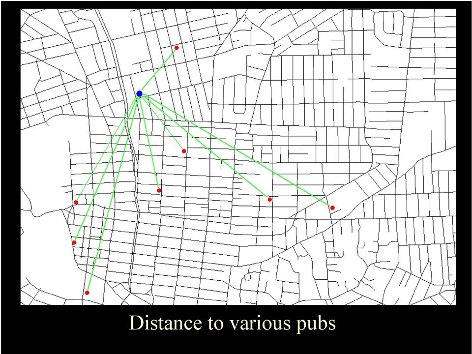
11 Spatial Relationships Not just interested in location, also interested in Relationships between objects that are very hard to model outside the spatial domain. The most common relationships are Proximity : distance Adjacency : touching and connectivity Containment : inside/overlapping

12 Spatial Relationships Distance between a toxic waste dump and a piece of property you were considering buying.

13 Spatial Relationships Distance to various pubs
14 Spatial Relationships Adjacency: All the lots which share an edge

15 Connectivity: Tributary relationships in river networks

16 Spatial Relationships Containment: Rivers inside watersheds and land (islands) inside lakes
 inside")
17 Spatial Relationships Stream side logging - adjacency and containment.

18 Most Organizations have Spatial Data Geocodable addresses Customer location Store locations Transportation tracking Statistical/Demographic Cartography Epidemiology Crime patterns Weather Information Land holdings Natural resources City Planning Environmental planning Information Visualization Hazard detection

19 Why put spatial data in a RDBMS? Spatial data is usually related to other types of data. Allows one to encode more complex spatial relationships. Fire Hydrant: number of uses, service area, last maintenance date. River: flow, temperature, fish presence, chemical concentrations Forested Area: monetary value, types of trees, ownership

20 Historically? In early GIS implementations, spatial data and related attribute information were stored separately. The attribute information was in a database (or flat file), while the spatial information was in a separate, proprietary, GIS file structure. For example, municipalities often would store property line information in a GIS file and ownership information in a database. Spatial databases were born when people started to treat spatial information as first class database objects.

21 Advantages of Spatial Databases Able to treat your spatial data like anything else in the DB transactions backups integrity checks less data redundancy fundamental organization and operations handled by the DB multi-user support security/access control locking
22
23 Advantages of Spatial Databases Offset complicated tasks to the DB server organization and indexing done for you do not have to re-implement operators do not have to re-implement functions Significantly lowers the development time of client applications
24 Advantages of Spatial Databases Spatial querying using SQL use simple SQL expressions to determine spatial relationships distance adjacency containment use simple SQL expressions to perform spatial operations area length intersection union buffer
25 Original Polygons Union Intersection
26 Original river network Buffered rivers
27 Advantages of Spatial Databases WHERE distance(<me>,pub_loc) < 1000 SELECT distance(<me>,pub_loc)*$ beer_cost... WHERE touches(pub_loc, street) WHERE inside(pub_loc,city_area) and city_name =...
28 Advantages of Spatial Databases Simple value of the proposed lot Area(<my lot>) * <price per acre> + area(intersect(<my log>,<forested area>) ) * <wood value per acre> - distance(<my lot>, <power lines>) * <cost of power line laying>
29 New Electoral Districts Changes in areas between 1996 and 2001 election. Want to predict voting in 2001 by looking at voting in Intersect the 2001 district polygon with the voting areas polygons. Outside will have zero area Inside will have 100% area On the border will have partial area Multiply the % area by 1996 actual voting and sum Result is a simple prediction of 2001 voting More advanced: also use demographic data.
30 Disadvantages of Spatial Databases Cost to implement can be high Some inflexibility Incompatibilities with some GIS software Slower than local, specialized data structures User/managerial inexperience and caution
31 Spatial Database Offerings ESRI ArcSDE (on top of several different DBs) Oracle Spatial IBM DB2 Spatial Extender Informix Spatial DataBlade MS SQL Server (with ESRI SDE) Geomedia on MS Access PostGIS / PostgreSQL
32 The OpenGIS Consortium From the OpenGIS Consortium guide Much geospatial data is available on the web and in off-line archives, but it is complex, heterogeneous, and incompatible. Users must possess considerable expertise and special geographic information system (GIS) software to overlay or otherwise combine different map layers of the same geographic region. Data conversion is cumbersome and time-consuming, and the results are often unsatisfactory. Common interfaces are the only way to enable overlays and combinations of complex and essentially different kinds of geographic information to happen automatically over the Internet, despite differences in the underlying GIS software systems. OGC brings together the key players and provides a formal structure for achieving consensus on the common interfaces.
33 The OpenGIS Consortium From the OpenGIS Consortium FAQ OpenGIS is defined as transparent access to heterogeneous geodata and geoprocessing resources in a networked environment. The goal of the OpenGIS Project is to provide a comprehensive suite of open interface specifications that enable developers to write inter-operating components that provide these capabilities.
34 Who is involved in the OpenGIS Consortium? ESRI Oracle IBM and Informix Intergraph Bentley (Microstation) MapInfo MicroSoft AutoDesk
35 Important OpenGIS Publications Simple Features Specification for OLE/COM for COBRA for SQL Web Map Server Specification (WMS) Web Feature Server Specification (WFS)
36 Why make PostgreSQL into an OpenGIS SFSQL Spatial DB? Why choose PostgreSQL? Proven reliability and respect No cost (open source) Supports most of the SQL standard Ability to add new data-types TOAST - no limit on column size GiST index / Index extensions Easy to add custom functions
37 Why make PostgreSQL into an OpenGIS SFSQL Spatial DB? Why choose OpenGIS SFSQL? Third Party reviewed roadmap One of the only open, respected standards Participation by the major GIS/DB organizations Other spatial DB are at least partially compliant Future interoperability/exchangeability with other DBs SFSQL provides complex functionality required by Web Feature Server / Web Map Server User familiarity
38 Implementing the OpenGIS specification. Understand the Specification Much harder than it sounds Add a GEOMETRY data type Point / Multipoint Linestring / Multilinestring Polygon / Multipolygon GeometryCollection Add support functions (and types)
39 Spatial Indexing Used the GiST (Generalized Search Tree) index Actively being developed Teodor Sigaev and Oleg Bartunov Fast index creation Handles compression use bounding box of the feature NULL safe Can implement an R-Tree using GiST
40 R-Tree Indexing Generalize all the geometries to their bounding box. small to store operations are simple Typical search is to find all the objects that overlap a box Result is an approximation too many features are returned Used to solve overlap and distance problems
41 Overlap R-Tree Indexing
42 Distance R-Tree Indexing
43 Guttman A.: 'R-trees: A Dynamic Index Structure for Spatial Searching', Proc ACM SIGMOD Int. Conf. on Management of Data, 1984
44 SQL example Create pubs table create table pubs (name varchar, beer_price float4); addgeometrycolumn( beer_db,'pubs','location,2167,'point',3);
45 Insert data insert into pubs values ( 'Garricks Head', 4.50, GeometryFromText( 'POINT ( ),2167) );
46 Perform Query select name, beer_price, distance(location, GeometryFromText('POINT( )',2167)) from pubs order by beer_price; name beer_price distance Fireside The Forge Rumours Garricks Head Slap Happy Old Bailys Black Sheep Big Bad Daves
47 Perform Query select name, beer_price * distance(location, GeometryFromText('POINT( )',2167)) as net_price from pubs order by price; name net_price Garricks Head Black Sheep Big Bad Daves Old Bailys Fireside The Forge Slap Happy Rumours
48 What talks to PostGIS? Client Software Uses standard SQL so can connect to it from any client FME (Safe Software): GIS translation/processing Mapserver ( an OpenGIS Web Map Server OGR ( - open source GIS reader/writer ESRI shapefile reader/writer In progress: ESRI ArcGIS connection, AutoCAD, Java Viewer, Web Feature Server
49 Open Standards in a Proprietary World Biggest obstacle is that most GIS companies have a closed/proprietary method for accessing and organizing spatial data ERSI s SDE (US$10,000) is required to effectively connect its software to a spatial database. As explained above, ArcSDE is the gateway to the DBMS for ESRI's client applications. Without ArcSDE, customer sites are limited in what they can do with their spatial databases. - ESRI s ARC-SDE FAQ (
50 Status PostGIS 0.6 was released last week Implements all of the OGC specification except the hard spatial operations. Over 500 downloads and many people actually using it The PostGIS development team is working with Vivid Solutions to include the Java Topology Suite (JTS). The JTS is an open source, rigorous, and robust implementation of OGC compliant spatial operations. Martin Davis
51 Conclusions PostGIS spatially enables PostgreSQL by adding spatial objects, functions, and indexing. PostGIS is free software (GPL) PostGIS follows the OpenGIS Simple Features for SQL hope it will be certified next year PostGIS is an important component in open and free GIS. PostGIS is an important building block for all future open source spatial projects.
52 Questions David Blasby Refractions Research
Pennsylvania Geospatial Data Sharing Standards (PGDSS) V 2.5
 V 2.5") Submitted to: Pennsylvania Geospatial Data Sharing Standards (PGDSS) V 2.5 Spatial Data Migration Tools Report May 2, 2007 Table of Contents 1.0 Document Purpose...B-1 2.0 Overview of Spatial Data Migration
Submitted to: Pennsylvania Geospatial Data Sharing Standards (PGDSS) V 2.5 Spatial Data Migration Tools Report May 2, 2007 Table of Contents 1.0 Document Purpose...B-1 2.0 Overview of Spatial Data Migration
ARCHITECTURE OF INTEGRATED GIS AND GPS FOR VEHICLE MONITORING
 1 st Logistics International Conference Belgrade, Serbia 28-30 November 2013 ARCHITECTURE OF INTEGRATED GIS AND GPS FOR VEHICLE MONITORING Adela B. Crnišanin * State University of Novi Pazar, Department
Open Source GIS The Future?
 Open Source GIS The Future? Daniel Morissette DM Solutions Group Inc. Open Source Licensing No licensing costs Unlimited rights to: Use the software View and analyse the source Copy, reuse in other systems
IBM Informix. Reference Documentation on Why Informix Spatial for GIS Projects
 IBM Informix Reference Documentation on Why Informix Spatial for GIS Projects Page 1 of 10 Contents Compliant with OGC... 3 Addressing the SQL standards... 3 Native Spatial, Intuitive Data Types... 3 Powerful
Frank Warmerdam President, OSGeo
 PostGIS: A Standards Based Geographic Extension for PostgreSQL Frank Warmerdam President, OSGeo 1 Overview Brief background PostGIS Details PostGIS Ex am ples Survey of Sim ple Features 1.1 Geom etries
10. Creating and Maintaining Geographic Databases. Learning objectives. Keywords and concepts. Overview. Definitions
 10. Creating and Maintaining Geographic Databases Geographic Information Systems and Science SECOND EDITION Paul A. Longley, Michael F. Goodchild, David J. Maguire, David W. Rhind 005 John Wiley and Sons,
GIS Databases With focused on ArcSDE
 Linköpings universitet / IDA / Div. for human-centered systems GIS Databases With focused on ArcSDE Imad Abugessaisa [email protected] 20071004 1 GIS and SDBMS Geographical data is spatial data whose
ArcGIS. Server. A Complete and Integrated Server GIS
 ArcGIS Server A Complete and Integrated Server GIS ArcGIS Server A Complete and Integrated Server GIS ArcGIS Server enables you to distribute maps, models, and tools to others within your organization
Cookbook 23 September 2013 GIS Analysis Part 1 - A GIS is NOT a Map!
 Cookbook 23 September 2013 GIS Analysis Part 1 - A GIS is NOT a Map! Overview 1. A GIS is NOT a Map! 2. How does a GIS handle its data? Data Formats! GARP 0344 (Fall 2013) Page 1 Dr. Carsten Braun 1) A
A Web services solution for Work Management Operations. Venu Kanaparthy Dr. Charles O Hara, Ph. D. Abstract
 A Web services solution for Work Management Operations Venu Kanaparthy Dr. Charles O Hara, Ph. D Abstract The GeoResources Institute at Mississippi State University is leveraging Spatial Technologies and
Data Integration for ArcGIS Users Data Interoperability. Charmel Menzel, ESRI Don Murray, Safe Software
 Data Integration for ArcGIS Users Data Interoperability Charmel Menzel, ESRI Don Murray, Safe Software Product overview Extension to ArcGIS (optional) Jointly developed with Safe Software Based on Feature
Basics on Geodatabases
 Basics on Geodatabases 1 GIS Data Management 2 File and Folder System A storage system which uses the default file and folder structure found in operating systems. Uses the non-db formats we mentioned
ArcGIS 10.1 Geodatabase Administration. Gordon Sumerling & Christopher Brown
 ArcGIS 10.1 Geodatabase Administration Gordon Sumerling & Christopher Brown Key Improvements at ArcGIS 10.1 1. Easier Administration through Graphic Interfaces 2. Greater Seamless integration with Open
ELECTRONIC JOURNAL OF POLISH AGRICULTURAL UNIVERSITIES
 Electronic Journal of Polish Agricultural Universities (EJPAU) founded by all Polish Agriculture Universities presents original papers and review articles relevant to all aspects of agricultural sciences.
SQL SUPPORTED SPATIAL ANALYSIS FOR WEB-GIS INTRODUCTION
 SQL SUPPORTED SPATIAL ANALYSIS FOR WEB-GIS Jun Wang Jie Shan Geomatics Engineering School of Civil Engineering Purdue University 550 Stadium Mall Drive, West Lafayette, IN 47907 ABSTRACT Spatial analysis
Spatial data models (types) Not taught yet
 Not taught yet") Spatial data models (types) Not taught yet A new data model in ArcGIS Geodatabase data model Use a relational database that stores geographic data A type of database in which the data is organized across
Spatial data models (types) Not taught yet A new data model in ArcGIS Geodatabase data model Use a relational database that stores geographic data A type of database in which the data is organized across
Geodatabase Programming with SQL
 DevSummit DC February 11, 2015 Washington, DC Geodatabase Programming with SQL Craig Gillgrass Assumptions Basic knowledge of SQL and relational databases Basic knowledge of the Geodatabase We ll hold
Supported DBMS platforms DB2. Informix. Enterprise ArcSDE Technology. Oracle. GIS data. GIS clients DB2. SQL Server. Enterprise Geodatabase 9.
 ArcSDE Administration for PostgreSQL Ale Raza, Brijesh Shrivastav, Derek Law ESRI - Redlands UC2008 Technical Workshop 1 Outline Introduce ArcSDE technology for PostgreSQL Implementation PostgreSQL performance
UK Location Programme
 Location Information Interoperability Board Data Publisher How To Guide Understand the background to establishing an INSPIRE View Service using GeoServer DOCUMENT CONTROL Change Summary Version Date Author/Editor
The GeoMedia Architecture Advantage. White Paper. April 2002. The GeoMedia Architecture Advantage Page 1
 The GeoMedia Architecture Advantage White Paper April 2002 The GeoMedia Architecture Advantage Page 1 Introduction What is wrong with GIS? GIS is primarily about data not software. Data should be independent
Attribute Data and Relational Database. Lecture 5 9/21/2006
 Attribute Data and Relational Database Lecture 5 9/21/2006 definition Attribute data is about what of a spatial data and is a list or table of data arranged as rows and columns Rows are records (map features)
DATABASE MANAGEMENT FILES GIS06
 DATABASE MANAGEMENT Last day we looked at spatial data structures for both vector and raster data models. When working with large amounts of data, it is important to have good procedures for managing the
Chapter 1: Introduction to ArcGIS Server
 Chapter 1: Introduction to ArcGIS Server At a high level you can think of ArcGIS Server as software that helps you take your geographic information and make it available to others. This data can be distributed
Working with the Geodatabase Using SQL
 An ESRI Technical Paper February 2004 This technical paper is aimed primarily at GIS managers and data administrators who are responsible for the installation, design, and day-to-day management of a geodatabase.
GeoPackage, The Shapefile Of The Future
 FOSS4G 2013 GeoPackage, The Shapefile Of The Future @PirminKalberer Sourcepole AG, Switzerland www.sourcepole.com About Sourcepole > QGIS > Core dev. & Project Steering Commitee > QGIS Server, Printing,
Introduction to PostGIS
 Tutorial ID: IGET_WEBGIS_002 This tutorial has been developed by BVIEER as part of the IGET web portal intended to provide easy access to geospatial education. This tutorial is released under the Creative
County of Los Angeles. Chief Information Office Preferred Technologies for Geographic Information Systems (GIS) September 2014
 September 2014") County of Los Angeles Chief Information Office Preferred Technologies for Geographic Information Systems (GIS) September 2014 CIO Preferred Technologies for GIS This document lists the preferred Geographic
County of Los Angeles Chief Information Office Preferred Technologies for Geographic Information Systems (GIS) September 2014 CIO Preferred Technologies for GIS This document lists the preferred Geographic
Choosing the right GIS framework for an informed Enterprise Web GIS Solution
 13 ANNUAL INTERNATIONAL CONFERENCE AND EXHIBITION ON GEOSPATIAL INFORMATION TECHNOLOGY AND APPLICATIONS Epicentre; Gurgaon, India; 19-21 January, 2010 Choosing the right GIS framework for an informed Enterprise
gvsig: A GIS desktop solution for an open SDI.
 gvsig: A GIS desktop solution for an open SDI. ALVARO ANGUIX1, LAURA DÍAZ1, MARIO CARRERA2 1 IVER Tecnologías de la Información. Valencia, Spain. Tel. +34 96 316 34 00; Fax. +34 96 316 34 00 Email: [email protected]
Abstract. Introduction
 Data Replication and Data Sharing Integrating Heterogeneous Spatial Databases Mark Stoakes and Katherine Irwin Professional Services, Safe Software Inc. Abstract Spatial data warehouses are becoming more
Documentation of open source GIS/RS software projects
 Contract no. Workpackage Delivery Delivery Date 030776 WP1 D1.6 2007-07-02 CASCADOSS Development of a trans-national cascade training programme on Open Source GIS&RS Software for environmental applications
PostGIS Data Integration
 PostGIS Data Integration & Display on SIS Alex Hill GIS Manager Contents Plus Dane Group who we are PostGIS Data Integration and Display on SIS What is a Spatial Database? What is PostgreSQL/PostGIS? Why
Institute of Computational Modeling SB RAS
 Institute of Computational Modeling SB RAS ORGANIZATION OF ACCESS TO OBSERVATIONAL DATA USING WEB SERVICES FOR MONITORING SYSTEMS THE STATE OF THE ENVIRONMENT Kadochnikov Aleksey A. Russia, Krasnoyarsk
Texas Develops Online Geospatial Data Repository to Support Emergency Management
 Bing Maps for Enterprise Microsoft Customer Solution Case Study Texas Develops Online Geospatial Data Repository to Support Emergency Management Overview Country or Region: United States Industry: Government
About scope of OpenGIS technology in oceanographic data management and visualization Andrey V. Golik, Vitaly K. Fischenko, Stepan G.
 About scope of OpenGIS technology in oceanographic data management and visualization Andrey V. Golik, Vitaly K. Fischenko, Stepan G. Antushev V.I.Il ichev Pacific Oceanological Institute Far-Eastern Branch
Introduction to Geospatial Web Services
 Geospatial Web Services Introduction to Geospatial Web Services An introduction and inventory of geospatial web services and their importance to interoperability in the geospatial domain. vers. 20100604
Archival Challenges Associated with the Esri Personal Geodatabase and File Geodatabase Formats
 Geospatial Multistate Archive and Preservation Partnership (GeoMAPP) Archival Challenges Associated with the Esri Personal Geodatabase and File Geodatabase Formats December 6, 2011 Introduction Spatial
(Geo)database and Data Management
database and Data Management") (Geo)database and Data Management An introduction to the possibilities of a centralized (spatial) data storing and access as well as its data management constraints (GLOWA Volta Project) GLOWA Volta Project
(Geo)database and Data Management An introduction to the possibilities of a centralized (spatial) data storing and access as well as its data management constraints (GLOWA Volta Project) GLOWA Volta Project
Introduction to GIS (Basics, Data, Analysis) & Case Studies. 13 th May 2004. Content. What is GIS?
 & Case Studies. 13 th May 2004. Content. What is GIS?") Introduction to GIS (Basics, Data, Analysis) & Case Studies 13 th May 2004 Content Introduction to GIS Data concepts Data input Analysis Applications selected examples What is GIS? Geographic Information
Introduction to GIS (Basics, Data, Analysis) & Case Studies 13 th May 2004 Content Introduction to GIS Data concepts Data input Analysis Applications selected examples What is GIS? Geographic Information
Oklahoma s Open Source Spatial Data Clearinghouse: OKMaps
 Oklahoma s Open Source Spatial Data Clearinghouse: OKMaps Presented by: Mike Sharp State Geographic Information Coordinator Oklahoma Office of Geographic Information MAGIC 2014 Symposium April 28-May1,
Editing Strategies for Enterprise Geodatabase
 Federal GIS Conference February 9 10, 2015 Washington, DC Editing Strategies for Enterprise Geodatabase Ty Fabling Esri Solution Engineer A Complete Platform Enabling GIS Everywhere Desktop Web Device
Database-driven web mapping using jquery, PHP, PostgreSQL & SDE
 Database-driven web mapping using jquery, PHP, PostgreSQL & SDE By, Jon Nordling, Michael Humber Inbal Becker-Reshef, Brian Barker, Katie McGaughey, Chris Justice University of Maryland College Park http://geoglam-crop-monitor.org/
Open Source GIS. Open Source GIS. Agenda. Open Source. Typische GIS Funktionen. LOTS Bern 18.2.05
 Agenda LOTS Bern 18.2.05 Pirmin Kalberer Sourcepole AG, Bad Ragaz www.sourcepole.ch Typische GIS Anwendungen Datenformate und GIS-Datenbanken Standards & Protokolle Bibliotheken & Applikationen Fragen
OSGeo Web Mapping Typification: GeoMajas, Mapbender, MapFish and OpenLayers. Christoph Baudson Arnulf Christl FOSS4G 2010 Barcelona
 OSGeo Web Mapping Typification: GeoMajas, Mapbender, MapFish and OpenLayers Christoph Baudson Arnulf Christl FOSS4G 2010 Barcelona Disclaimer All information contained in this presentation has been compiled
Vector analysis - introduction Spatial data management operations - Assembling datasets for analysis. Data management operations
 Vector analysis - introduction Spatial data management operations - Assembling datasets for analysis Transform (reproject) Merge Append Clip Dissolve The role of topology in GIS analysis Data management
An Introduction to Open Source Geospatial Tools
 An Introduction to Open Source Geospatial Tools by Tyler Mitchell, author of Web Mapping Illustrated GRSS would like to thank Mr. Mitchell for this tutorial. Geospatial technologies come in many forms,
ArcSDE Spatial Data Management Roles and Responsibilities
 ArcSDE Spatial Data Management Roles and The following discussion outlines the major roles and responsibilities involved in deploying your spatial data and geographic information system (GIS) applications
ADVANCED DATA STRUCTURES FOR SURFACE STORAGE
 1Department of Mathematics, Univerzitni Karel, Faculty 22, JANECKA1, 323 of 00, Applied Pilsen, Michal, Sciences, Czech KARA2 Republic University of West Bohemia, ADVANCED DATA STRUCTURES FOR SURFACE STORAGE
Standards based spatial data management, GIS and web mapping. Spatial data management, analysis & sharing the free & easy way!
 or Spatial data management, analysis & sharing the free & easy way! Premise: Traditional GIS is inherently flawed, especially when it comes to many fisheries/maritime datasets Premise: Traditional GIS
EXPLORING AND SHARING GEOSPATIAL INFORMATION THROUGH MYGDI EXPLORER
 EXPLORING AND SHARING GEOSPATIAL INFORMATION THROUGH MYGDI EXPLORER Subashini Panchanathan Malaysian Centre For Geospatial Data Infrastructure ( MaCGDI ) Ministry of National Resources and Environment
Oracle Platform GIS & Location-Based Services. Fred Louis Solution Architect Ohio Valley
 Oracle Platform GIS & Location-Based Services Fred Louis Solution Architect Ohio Valley Overview Geospatial Technology Trends Oracle s Spatial Technologies Oracle10g Locator Spatial Oracle Application
What is GIS? Geographic Information Systems. Introduction to ArcGIS. GIS Maps Contain Layers. What Can You Do With GIS? Layers Can Contain Features
 What is GIS? Geographic Information Systems Introduction to ArcGIS A database system in which the organizing principle is explicitly SPATIAL For CPSC 178 Visualization: Data, Pixels, and Ideas. What Can
Iraklis Karampourniotis, Zoi Arvanitidou, Ioannis Paraschakis. Using open source software in gis training and education
 Iraklis Karampourniotis, Zoi Arvanitidou, Ioannis Paraschakis Using open source software in gis training and education Can open source be used? The question troubling us was Can Open Source Software be
Oracle8i Spatial: Experiences with Extensible Databases
 Oracle8i Spatial: Experiences with Extensible Databases Siva Ravada and Jayant Sharma Spatial Products Division Oracle Corporation One Oracle Drive Nashua NH-03062 {sravada,jsharma}@us.oracle.com 1 Introduction
Managing a Geographic Database From Mobile Devices Through OGC Web Services
 Managing a Geographic Database From Mobile Devices Through OGC Web Services Nieves R. Brisaboa 1, Miguel R. Luaces 1, Jose R. Parama 1, and Jose R. Viqueira 2 1 Database Laboratory, University of A Coruña,
 Development tools to create Web-GIS applications DbMAP ASJ the best solution to easily publish GIS data from existing spatial databases and distributed GIS data sources Easily designs, produces, and publishes
Leveraging Geospatial Information Across the Enterprise: Bentley s Flexible Geospatial Approach
 Leveraging Geospatial Information Across the Enterprise: Bentley s Flexible Geospatial Approach A Bentley White Paper Gijsbert Noordam Product Manager Nicolas Loubier Senior Product Manager July 2012 www.bentley.com
ArcGIS Framework Plug-In: Extending the ArcGIS Desktop for ANSI Standard Framework Data to Support Government Decision Making
 ArcGIS Framework Plug-In: Extending the ArcGIS Desktop for ANSI Standard Framework Data to Support Government Decision Making Final Project Report October 28, 2008 Agreement Number Organization Project
GIS Data in ArcGIS. Pay Attention to Data!!!
 GIS Data in ArcGIS Pay Attention to Data!!! 1 GIS Data Models Vector Points, lines, polygons, multi-part, multi-patch Composite & secondary features Regions, dynamic segmentation (routes) Raster Grids,
Cloud application for water resources modeling. Faculty of Computer Science, University Goce Delcev Shtip, Republic of Macedonia
 Cloud application for water resources modeling Assist. Prof. Dr. Blagoj Delipetrev 1, Assist. Prof. Dr. Marjan Delipetrev 2 1 Faculty of Computer Science, University Goce Delcev Shtip, Republic of Macedonia
GeoKettle: A powerful open source spatial ETL tool
 GeoKettle: A powerful open source spatial ETL tool FOSS4G 2010 Dr. Thierry Badard, CTO Spatialytics inc. Quebec, Canada [email protected] Barcelona, Spain Sept 9th, 2010 What is GeoKettle? It is
A Hybrid Architecture for Mobile Geographical Data Acquisition and Validation Systems
 A Hybrid Architecture for Mobile Geographical Data Acquisition and Validation Systems Claudio Henrique Bogossian 1, Karine Reis Ferreira 1, Antônio Miguel Vieira Monteiro 1, Lúbia Vinhas 1 1 DPI Instituto
DATA SHARING AND SPATIAL QUERY
 Technical Memorandum No. 2 DATA SHARING AND SPATIAL QUERY Raghavan Srinivasan Spatial Sciences Laboratory Texas Agricultural Experiment Station, Texas A&M University Submitted to El Paso Water Utilities
Spatial Database Support
 Page 1 of 11 Spatial Database Support Global Mapper can import vector data from and export vector data to the following spatial databases: Esri ArcSDE Geodatabase Esri File Geodatabase Esri Personal Geodatabases
Introduction to Spatial Data Management with Postgis. Spatial Data Management
 Introduction to Spatial Data Management with Postgis Content Introduction Managing Spatial Data with PostGIS PostGIS Data Model Creating a PostGIS enabled Database Insert Coordinates using SQL Uploading
URISA Salary Survey for IT/GIS Professionals
 URISA Salary Survey for IT/GIS Professionals November 2011 Published by: The Urban and Regional Information Systems Association 701 Lee Street, Suite 680 Des Plaines, IL 60016 Phone: 847/824-6300, Fax:
Introduction to Using PostGIS Training Workbook Last Updated 18 June 2014
 Introduction to Using PostGIS Training Workbook Last Updated 18 June 2014 Prepared by: Simon Nitz, Senior Technical Consultant Digital Mapping Solutions NZ Limited 2nd Floor, 20 Bridge Street, Ahuriri,
[ DISTRIBUTING AVL USING ARCIMS
 [ DISTRIBUTING AVL USING ARCIMS The Chicago MAGIC Project ] GIS-T 2003 Colorado Springs presented by Louis Schoolkate Transportation Division Manager GeoAnalytics, Inc. 2002 [ Presentation Overview ] Project
Standardized data sharing through an open-source Spatial Data Infrastructure: the Afromaison project
 Standardized data sharing through an open-source Spatial Data Infrastructure: the Afromaison project Yaniss Guigoz - University of Geneva/GRID-Geneva 1 EcoARM2ERA and AFROMAISON Why Afromaison in this
ArcGIS : Engineered for Interoperability
 ArcGIS : Engineered for Interoperability An ESRI White Paper January 2006 ESRI 380 New York St., Redlands, CA 92373 8100, USA TEL 909 793 2853 FAX 909 793 5953 E MAIL [email protected] WEB www.esri.com Copyright
Institute of Natural Resources Departament of General Geology and Land use planning Work with a MAPS
 Institute of Natural Resources Departament of General Geology and Land use planning Work with a MAPS Lecturers: Berchuk V.Y. Gutareva N.Y. Contents: 1. Qgis; 2. General information; 3. Qgis desktop; 4.
A WEB GIS FOR WETLANDS OF KERALA USING OPEN SOURCE GEOSPATIAL SOFTWARE. Santosh Gaikwad* and S Narendra Prasad**
 A WEB GIS FOR WETLANDS OF KERALA USING OPEN SOURCE GEOSPATIAL SOFTWARE Santosh Gaikwad* and S Narendra Prasad** Salim Ali Centre for Ornithology and Natural History Deccan Regional Station, Hyderabad *[email protected]
GML support in software
 GML support in software Presented by Clemens Portele Slides by Marcel Reuvers & Linda van den Brink Courtesy of Wim van Berkel, TNO 27-5-2014 Ingrediënten voor slimme toepassingen Main question as starting
Web-based public participation GIS application - a case study on flood emergency management
 Student thesis series INES nr 263 Web-based public participation GIS application - a case study on flood emergency management Peng Wang 2012 Department of Physical Geography and Ecosystem Science Lund
Analysis of the Free GIS Software Applications in respect to INSPIRE services and OGC standards
 Analysis of the Free GIS Software Applications in respect to INSPIRE services and OGC standards Authors: Francesco D'Alesio Peter Hopfgartner Paolo Viskanic June 2011 Executive Summary This document analyses
The use of Semantic Web Technologies in Spatial Decision Support Systems
 The use of Semantic Web Technologies in Spatial Decision Support Systems Adam Iwaniak Jaromar Łukowicz Iwona Kaczmarek Marek Strzelecki The INSPIRE Conference 2013, 23-27 June Wroclaw University of Environmental
Step by Step Guide for GIS Cloud Applications
 Step by Step Guide for GIS Cloud Applications All in one manual for: Map Editor Map Viewer Asset Data Collection and Management Fleet Management Roadwork Management and Coordination Mobile Data Collection
Administering your PostgreSQL Geodatabase
 Jim Gough and Jim McAbee [email protected] [email protected] Agenda Workshop will be structured in 2 parts Part 1: Scenario Using Postgres for your Enterprise Geodatabase and how to get started. Part 2: Advanced
National critical geo infrastructure runs on open source database PostGIS
 National critical geo infrastructure runs on open source database PostGIS TU Delft Geomatics Open Guest Lecture March 21st 2011 Thijs Brentjens Who am I? TU Delft MSc Geodetic Engineering (2004) Thesis:
GeoKettle: A powerful spatial ETL tool for feeding your Spatial Data Infrastructure (SDI)
") GeoKettle: A powerful spatial ETL tool for feeding your Spatial Data Infrastructure (SDI) Dr. Thierry Badard, CTO [email protected] Spatialytics http://www.spatialytics.com FOSS4G 2011 Workshop,
GeoKettle: A powerful spatial ETL tool for feeding your Spatial Data Infrastructure (SDI) Dr. Thierry Badard, CTO [email protected] Spatialytics http://www.spatialytics.com FOSS4G 2011 Workshop,
Leveraging Geospatial Information Across the Enterprise: Bentley s Flexible Geospatial Approach
 Leveraging Geospatial Information Across the Enterprise: Bentley s Flexible Geospatial Approach A Bentley White Paper Gijsbert Noordam Senior Consultant, Geospatial Center of Excellence www.bentley.com
Future Trends in Geospatial Data Management Process Squadron Leader Mudit Mathur
 VOL 2 ISSUE 5 24 TOWARDS A NATIONAL SPATIAL DATA INFRASTRUC- TURE (NSDI) Dr. Talal Al-Awadhi 28 GEODATABASE FOR URBAN DESIGN AND PLANNING Simon Yanuar PUTRA 34 FREE, CHEAP, AND POW- ERFUL POSTGIS, THE
Terry Sherman Oklahoma South Central Arc-Users Group 2014 17 th Annual Conference 9/23/2014
 Terry Sherman Oklahoma South Central Arc-Users Group 2014 17 th Annual Conference 9/23/2014 About Terry Work: Research Cyberinfrastructure Analyst for OSU High Performance Computing Center developing research
Data Validation Online References
 Data Validation Online References Submitted To: Program Manager GeoConnections Victoria, BC, Canada Submitted By: Jody Garnett Brent Owens Refractions Research Inc. Suite 400, 1207 Douglas Street Victoria,
Interoperable Solutions in Web-based Mapping
 ISPRS SIPT IGU UCI CIG ACSG Table of contents Table des matières Authors index Index des auteurs Search Recherches Exit Sortir Interoperable Solutions in Web-based Mapping Marta Wojnarowska and Bridget
What s new in Carmenta Server 4.2
 What s new in Carmenta Server 4.2 A complete solution for cost-effective visualisation and distribution of GIS data through web services Carmenta Server provides cost-effective technology for building
Introduction to Geographic Information Systems. A brief overview of what you need to know before learning How to use any GIS software packages
 Introduction to Geographic Information Systems A brief overview of what you need to know before learning How to use any GIS software packages 1 What is GIS? More than map-making software GIS is a system
The Virtual Database A Tool for Integrated Data Processing in a Distributed Environment
 EnviroInfo 2004 (Geneva) Sh@ring EnviroInfo 2004 The Virtual Database A Tool for Integrated Data Processing in a Distributed Environment Marcel Frehner 1, Martin Brändli 2, Jürg Schenker 3 Abstract Traditional
MAY 18, 2015 ARCGIS 10.3.1 FOR SERVER FUNCTIONALITY MATRIX
 MAY 18, 2015 ARCGIS 10.3.1 FOR SERVER FUNCTIONALITY MATRIX Copyright 2015 Esri All rights reserved. Printed in the United States of America. The information contained in this document is the exclusive
DEVELOPMENT AND COMPARISON OF OPEN SOURCE BASED WEB GIS FRAMEWORKS ON WAMP AND APACHE TOMCAT WEB SERVERS
 DEVELOPMENT AND COMPARISON OF OPEN SOURCE BASED WEB GIS FRAMEWORKS ON WAMP AND APACHE TOMCAT WEB SERVERS Sonam Agrawal a, Rajan Dev Gupta b a GIS Cell, Motilal Nehru National Institute of Technology, Allahabad-211004,
Chapter 5 Spatial is not Special: Managing Tracking Data in a Spatial Database
 Chapter 5 Spatial is not Special: Managing Tracking Data in a Spatial Database Ferdinando Urbano and Mathieu Basille Abstract A wildlife tracking data management system must include the capability to explicitly
Integration of location based services for Field support in CRM systems
 Invited Contribution to GeoInformatics. Deadline September 15, 2001. Integration of location based services for Field support in CRM systems By P. Álvarez, J.A. Bañares, P.R. Muro-Medrano and F.J. Zarazaga
 Advanced ArcSDE Administration for SQL Server Shannon Shields Tony Wakim Workshop Format Three topics What's New In-depth Database Administration Trouble-shooting / Performance Selection varies year to
The Courses. Covering complete breadth of GIS technology from ESRI including ArcGIS, ArcGIS Server and ArcGIS Engine.
 ESRI India: Corporate profile ESRI India A profile India s Premier GIS Company Strategic alliance between ESRI Inc. and NIIT Technologies Adjudged as India s Best GIS Solutions Company - Map India 2001
Geospatially Enabling the World: The Convergence of Geospatial and Architectural and Engineering Design
 Geospatially Enabling the World: The Convergence of Geospatial and Architectural and Engineering Design Geoff Zeiss Director of Technology Autodesk Map Middle East Dubai 2007 1 Overview Geospatial inflection
Using SAS ACCESS to retrieve and store data in relational database management systems
 Using SAS ACCESS to retrieve and store data in relational database management systems Department of Biology Dalhousie University SHRUG meeting, February 23rd 2007 Disclaimer Background SAS is the only