Daniel Millls Senior GIS Consultant Liberation of spatial data within NI Water
|
|
|
- Paul Rose
- 8 years ago
- Views:
Transcription
1 Daniel Millls Senior GIS Consultant Liberation of spatial data within NI Water

2 Agenda Examine the business requirements to move towards a spatial data warehouse Implemented solution Solution restrictions Why Oracle? Locator or Spatial Current solution Closer examination of two areas Data integration GIS visualisation to the masses Conclusions Questions

3 Business requirements


4 NI Water GIS Metrics Infrastructure 26,435km water mains, 14,420km sewers, 476,204 manholes, 146,368 valves, 56,331 hydrants, 35,439 air valves Non-Infrastructure 5,180 Sites Facilities; 1,119 WWTW, 1,318 SPS, 735 CSO, 45 WTW, 429 SR, 231 WPS, 160 WBS Boundaries 1,271 DMAs, 2,059 DACs, 13,500 square km 4.8 million asset records Users 800 from across the business and beyond >10,000 hits per month

5 Business requirement Corporate Asset Register (CAR) Geospatially enabled Below ground; network assets. Mastered by GIS Above ground; sites, facilities Data centric solution Centralised storage of spatial data Data integration Update of legacy network maintenance tool (NIMS) Liberate!!

6 Migration restrictions Severe cost and time restrictions Limited data model changes permitted Most NIW resources taken up by above ground asset register implementation Make use of existing software licenses (PBBI MapInfo Professional) NIW must maintain IPR on new application NIW to control data model and not be restricted on access to underlying data

7 Implemented solution

8 Why Oracle? NIW already used Oracle for a number of systems Oracle SDO_GEOMETRY interoperable with all leading desktop GIS, including PBBI MapInfo Professional Other solutions where explored but rejected due to: Product infancy Lack of support Cost Speed of development and implementation

9 Locator or Spatial Locator Comes with Oracle Express or Standard at no extra cost Uses SDO_GEOMETRY Limited number of functions available Spatial Additional cost Upgrade to Oracle Enterprise In hindsight Locator would have done. There is no additional spatial functionality used in the implementation. However Spatial has enabled NI Water to embark on a number of integration and data quality improvement initiatives


10 Current components Cost to Serve

11 Liberation NI Water can modify data model as business requirements change Spatial data warehouse allows unrestricted access by NI Water to data AID staff have full ownership of database Create or amend table definitions Create triggers and stored procedures Create scheduled jobs Create user and defined privileges DBA provides technical advice and moral support!

12 Closer look: Ellipse Integration

")
13 Update schedules Real-Time Telemetry Real- Time/Snapshot Monthly snapshot Scheduled (nightly) Real-Time

14 Server side processing CARID is maintained by Oracle sequence prefixed with asset type Scheduled jobs allow intensive spatial processing to be conducted during periods of low use Triggers provide hidden population of fields On before insert of facilities spatial processing updates financial fields based on boundaries On before insert triggers populates calculated fields On before update of geometries causes geometry validation check and update of attributes Triggers validate geometries Triggers update audit tables used during integration processes

15 Geocoding Methodology Confidence Description Example Previous % of dataset Current % of dataset A Street Number, Street Name, City & 1st part of Postcode 12 Glebe Cottages, Ahoghill, BT B Street Number & Full Postcode 12, BT42 2PZ C Street Number, Street Name & 1st part of Postcode 12 Glebe Cottages, BT D Street Name and City Glebe Cottages, Ahoghill E Full Postcode BT42 2PZ F 1swt part of Postcode BT X Not geocoded Ahoghill Coumminty C, Culleybecky Road

16 GIS visualisation: CARtomap

17 CARtomap Web GIS Interface


18 Data Updates: DG3 Property Interruptions

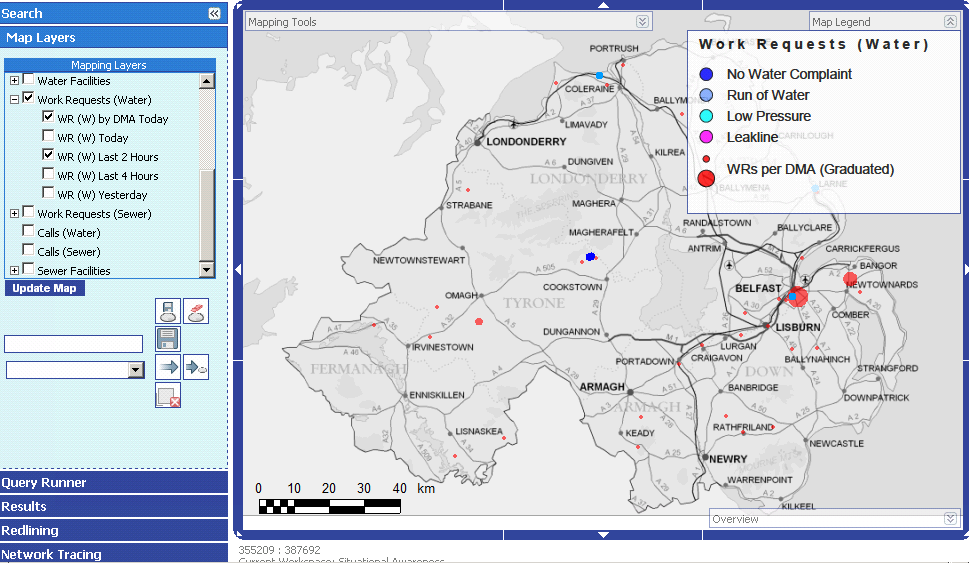
19 GIS visualisation: Situational Awareness

20 Situational Awareness Ability to provide information that quickly highlights key Operational Customer issues Tool to be used for Major Incident Planning management Tool to provide a level of on-going improvement analysis Aid to co-ordinate resources Near real time update of mapping with work request information XML retrieved by database Currently 20 minute interval using Oracle scheduled jobs. Can be adjusted by NI Water

21

22
23 GIS visualisation: New Customer Connections
24 New connections Requirement to reduce time taken to turn around application for a new connection. Real time update of Rapid dashboard required. Auto population of connection attributes Height data for meter, property and connection point taken from DEM stored as SDO_GEORASTER. Network attributes passed Users required to verify updates Updated connection details passed back to Rapid
25

26

27

28
29 Conclusions
30 The future Migration of all background data to Oracle Spatial OSNI vector background GeoRaster DEM data already in database Bypass upgrade to 11g Plans to move directly to 12c? Further integration with key systems Continue to promote spatial data warehouse within business Clustering solution required if current growth continues Develop internal systems using APEX installation imminent
31 If you build it, they will come (to misquote Field of Dreams).. and they have!
Dealing with Map Shift and Getting Out the Other Side Relatively Intact
 Dealing with Map Shift and Getting Out the Other Side Relatively Intact 11 th May 2016 Northern Ireland Water Sean O Boyle, Andrew Murphy & Michelle Cassidy Version 1.0 Introductions Sean O Boyle Asset
<Insert Picture Here> Data Management Innovations for Massive Point Cloud, DEM, and 3D Vector Databases
 Data Management Innovations for Massive Point Cloud, DEM, and 3D Vector Databases Xavier Lopez, Director, Product Management 3D Data Management Technology Drivers: Challenges & Benefits
Oracle Platform GIS & Location-Based Services. Fred Louis Solution Architect Ohio Valley
 Oracle Platform GIS & Location-Based Services Fred Louis Solution Architect Ohio Valley Overview Geospatial Technology Trends Oracle s Spatial Technologies Oracle10g Locator Spatial Oracle Application
Oracle BI and Geo-Spatial Big Data
 Oracle Business Intelligence 11g Antony Heljula Technical Director Peak Indicators Limited 2 Introduction Aim of Presentation 5 Steps for Demonstration Summary Further Information Questions Peak Indicators
May 2012 Oracle Spatial User Conference
 1 May 2012 Oracle Spatial User Conference May 23, 2012 Ronald Reagan Building and International Trade Center Washington, DC USA Amit Ghosh Lead Architect, Nokia How Nokia Uses Oracle Spatial to Create
Enterprise GIS Solutions to GIS Data Dissemination
 Enterprise GIS Solutions to GIS Data Dissemination ESRI International User Conference July 13 17, 2009 Wendy M. Turner Senior GIS Engineer & Program Manager Freedom Consulting Group, LLC Building the Enterprise
Databases for 3D Data Management: From Point Cloud to City Model
 Databases for 3D Data Management: From Point Cloud to City Model Xavier Lopez, Ph.D. Senior Director, Spatial and Graph Technologies Oracle Program Agenda Approach: Spatially-enable the Enterprise Oracle
White Paper. www.geodecisions.com
 White Paper www.geodecisions.com A Geo Spatial Total Asset Management System (TAMS) To Improve Asset Management Decision Making Fall 2013 Abstract This paper describes a Geospatial Total Asset Management
Transactional Updates to Enterprise GIS data sets. Presented by: Kelly Ratchinsky PBC Countywide GIS Coordinator
 Transactional Updates to Enterprise GIS data sets Presented by: Kelly Ratchinsky PBC Countywide GIS Coordinator The Enterprise Environment Countywide GIS Centralized GIS Data Repository Departmental GIS
March 2008. Oracle Spatial User Conference
 March 13, 2008 Sheraton Seattle Hotel Seattle, Washington USA Robert Murray RL Polk Steven Pierce Johnston McLamb Unobtrusive Spatial Enablement of the Oracle BI Suite R.L. Polk Location Intelligence RL
Oracle10g & Beyond. Justin Lokitz. Senior Member - Technical Staff GIS/Web Development Specialist
 Oracle10g & Beyond Justin Lokitz Senior Member - Technical Staff GIS/Web Development Specialist What is spatial data? Spatial data is ubiquitous Business data that contains or describes location Street
2010 Oracle Corporation 1
 1 Introduction to Geospatial Visualization in Oracle Business Intelligence Enterprise Edition, 11g Product Mgmt., Oracle Business Intelligence and Spatial Agenda Introduction When
Inframoura. Migrating from ArcGIS to Boundless OpenGeo Suite. Diogo Vitorino
 Inframoura Migrating from ArcGIS to Boundless OpenGeo Suite Diogo Vitorino Geospatial World Forum, Lisbon May, 2015 Vilamoura, Portugal Inframoura Vilamoura, Portugal Vilamoura is one of the largest tourist
Kingdom Of Bahrain Ministry of Works. Enterprise Asset Management System A Geocentric Approach. Presented By Hisham Y.
 Kingdom Of Bahrain Ministry of Works Enterprise Asset Management System A Geocentric Approach Presented By Hisham Y. Sater April 2012 Ministry Of Works Bahrain MOW The construction arm of the Kingdom of
Technical Management Strategic Capabilities Statement. Business Solutions for the Future
 Technical Management Strategic Capabilities Statement Business Solutions for the Future When your business survival is at stake, you can t afford chances. So Don t. Think partnership think MTT Associates.
From Business Intelligence to Location Intelligence with the Lily Library
 From Business Intelligence to Location Intelligence with the Lily Library Matteo Golfarelli Stefano Rizzi Marco Mantovani Federico Ravaldi Agenda Location Intelligence State of the art Lily Features Architecture
Track 1: Managing network assets
 the agi conference at GIS 2002 A05.2 Track 1: Managing network assets Delivering and realising the benefits of Multi-utility GIS systems for United Utilities Clive Deadman, General Manager, Asset Records,
A Solution to MOP/MAOP Data Management in PODS
 2013 Esri International User Conference July 8 12, 2013 San Diego, California A Solution to MOP/MAOP Data Management in PODS Chevron Pipe Line Company Nathan Marx, GIS Project Manager Marsh Wong, IT Systems
Enabling ITIL Best Practices Through Oracle Enterprise Manager, Session #081163 Ana Mccollum Enterprise Management, Product Management
 Enabling ITIL Best Practices Through Oracle Enterprise Manager, Session #081163 Ana Mccollum Enterprise Management, Product Management Andy Oppenheim Enterprise Management, Product Management Mervyn Lally
Corporate Spatial Data Infrastructure. Governance
 Version History Version Date Author Description 1.0 June 2, 2006 C. Almstrom Initial draft 2.0 August 14, 2006 L. Crooks, N. 1 st draft Parry, C. Almstrom, D. Davidson 2.0 October 13, 2006 N.Parry 2 nd
End the Microsoft Access Chaos - Your simplified path to Oracle Application Express
 End the Microsoft Access Chaos - Your simplified path to Oracle Application Express Donal Daly Senior Director, Database Tools Agenda Why Migrate from Microsoft Access? What is Oracle
NatureServe s Environmental Review Tool
 NatureServe s Environmental Review Tool A Repeatable Online Software Solution for Agencies For More Information, Contact: Lori Scott Rob Solomon lori_scott@natureserve.org rob_solomon@natureserve.org 703-908-1877
Web and Mobile GIS in Local Authorities in Ireland Ciarán Kirk, IMGS
 Web and Mobile GIS in Local Authorities in Ireland Ciarán Kirk, IMGS We deliver innovative spatial solutions for the desktop, web & mobile Built on our partner s technology Designed to meet the challenges
A Web services solution for Work Management Operations. Venu Kanaparthy Dr. Charles O Hara, Ph. D. Abstract
 A Web services solution for Work Management Operations Venu Kanaparthy Dr. Charles O Hara, Ph. D Abstract The GeoResources Institute at Mississippi State University is leveraging Spatial Technologies and
Geodatabase Programming with SQL
 DevSummit DC February 11, 2015 Washington, DC Geodatabase Programming with SQL Craig Gillgrass Assumptions Basic knowledge of SQL and relational databases Basic knowledge of the Geodatabase We ll hold
Fairfax County simplifies GIS search and opens more data to the public
 Fairfax County simplifies GIS search and opens more data to the public Fairfax County, Virginia has used MarkLogic to help simplify the process of searching data from dozens of geospatial information system
The GeoMedia Architecture Advantage. White Paper. April 2002. The GeoMedia Architecture Advantage Page 1
 The GeoMedia Architecture Advantage White Paper April 2002 The GeoMedia Architecture Advantage Page 1 Introduction What is wrong with GIS? GIS is primarily about data not software. Data should be independent
FME 2007 Release Giving Raster the Vector Treatment. By Mary Jo Wagner
 FME 2007 Release Giving Raster the Vector Treatment By Mary Jo Wagner Giving Raster the Vector Treatment By Mary Jo Wagner Spatial extract, transform and load (ETL) tools such as Safe Software s FME have
Data Integration for ArcGIS Users Data Interoperability. Charmel Menzel, ESRI Don Murray, Safe Software
 Data Integration for ArcGIS Users Data Interoperability Charmel Menzel, ESRI Don Murray, Safe Software Product overview Extension to ArcGIS (optional) Jointly developed with Safe Software Based on Feature
Big Data and Analytics: Getting Started with ArcGIS. Mike Park Erik Hoel
 Big Data and Analytics: Getting Started with ArcGIS Mike Park Erik Hoel Agenda Overview of big data Distributed computation User experience Data management Big data What is it? Big Data is a loosely defined
Reducing backup windows and increasing performance when data. reaches the terabyte range
 Reducing backup windows and increasing performance when data PRESENTATION TITLE GOES HERE reaches the terabyte range Mark McKinnon Grand River Conservation Authority Our Organization Grand River Conservation
TRACES: REVEAL THE PERFORMANCE OF YOUR MISSION CRITICAL NETWORK
 TRACES: REVEAL THE PERFORMANCE OF YOUR MISSION CRITICAL NETWORK THE NEED FOR COST- EFFICIENT NETWORK MEASUREMENT Your people face demanding situations every day. To complete their missions and safeguard
IBM Informix. Reference Documentation on Why Informix Spatial for GIS Projects
 IBM Informix Reference Documentation on Why Informix Spatial for GIS Projects Page 1 of 10 Contents Compliant with OGC... 3 Addressing the SQL standards... 3 Native Spatial, Intuitive Data Types... 3 Powerful
An Esri White Paper January 2011 HL7 and Spatial Interoperability Standards for Public Health and Health Care Delivery
 An Esri White Paper January 2011 HL7 and Spatial Interoperability Standards for Public Health and Health Care Delivery Esri, 380 New York St., Redlands, CA 92373-8100 USA TEL 909-793-2853 FAX 909-793-5953
PROFESSIONAL SERVICES
 v.2016.02 PROFESSIONAL SERVICES Training Services Computrition offers a wide array of training services to streamline the implementation process. Of all the factors critical to the success of an automation
ishare in the Cloud Service Definition v5.0
 Service Definition v5.0 An overview of ishare in the Cloud ishare is an end to end Enterprise GIS for public sector comprising a spatial data warehouse, rich functionality browser based GIS including editing
GeoKettle: A powerful open source spatial ETL tool
 GeoKettle: A powerful open source spatial ETL tool FOSS4G 2010 Dr. Thierry Badard, CTO Spatialytics inc. Quebec, Canada tbadard@spatialytics.com Barcelona, Spain Sept 9th, 2010 What is GeoKettle? It is
GeoMedia Product Update. Title of Presentation. Lorilie Barteski October 15, 2008 Edmonton, AB
 Product Update Title of Presentation Lorilie Barteski Edmonton, AB Know the audience poll Existing /Pro users Version 6.1 Version 6.0 Version 5.2 or earlier Existing WebMap users Version 6.1 Version 6.0
Introduction of spatial enabled data warehouse technology across the enterprise
 Introduction of spatial enabled data warehouse technology across the enterprise Geospatial World Forum 23. 27. April, Amsterdam Joachim Figura, CISS TDI GmbH Agenda Company Profile The 3 Use Cases Herten,Siegen,
HP Quality Center. Upgrade Preparation Guide
 HP Quality Center Upgrade Preparation Guide Document Release Date: November 2008 Software Release Date: November 2008 Legal Notices Warranty The only warranties for HP products and services are set forth
INCOG Transportation Planning Division Spatial Data Management Workflow GIS-T 2008
 INCOG Transportation Planning Division Spatial Data Management Workflow GIS-T 2008 Kevin Tartar, GISP Transportation Geodatabase Coordinator 201 West 5th Street, Suite 600 Tulsa, Oklahoma 74103 Phone:
Implementing an Imagery Management System at Mexican Navy
 Implementing an Imagery Management System at Mexican Navy The Mexican Navy safeguards 11,000 kilometers of Mexican coastlines, inland water bodies suitable for navigation, and the territorial sea and maritime
Leveraging Cloud-Based Mapping Solutions
 Leveraging Cloud-Based Mapping Solutions GeoAlberta October 28, 2014 Laura Kerssens Safe Software Agenda To the Cloud Using Basic Services Cloud Applications Web Services Cloud-Hosted Databases Real-time
{ { { Meeting Date 08/03/10. City of Largo Agenda Item 24. Leland Dicus, P.E., City Engineer
 City of Largo Agenda Item 24 Form Revision Date: 10/19/09: Meeting Date 08/03/10 Presenter: Leland Dicus, P.E., City Engineer Department: CD Community Development TITLE: GIS PROGRAM UPDATE The implementation
Automate Your BI Administration to Save Millions with Command Manager and System Manager
 Automate Your BI Administration to Save Millions with Command Manager and System Manager Presented by: Dennis Liao Sr. Sales Engineer Date: 27 th January, 2015 Session 2 This Session is Part of MicroStrategy
NETWORK MONITORING. Network Monitoring. Product brief. NETWORK MONITORING Logger Only
 Network Monitoring 1 Network Monitoring Product brief Logger Only CONTENTS 1 Page 1. Introduction 2-3 2. Network Structure 4 3. Data Collection 5 4. Data Visualisation 6 5. Dashboard 7 6. Alarm Management
Online Data Delivery System
 Version: February 2014 Version 3.0 Disclaimer PSMA Australia believes this publication to be correct at the time of printing and does not accept responsibility for any consequences arising from the use
How To Use Hadoop For Gis
 2013 Esri International User Conference July 8 12, 2013 San Diego, California Technical Workshop Big Data: Using ArcGIS with Apache Hadoop David Kaiser Erik Hoel Offering 1330 Esri UC2013. Technical Workshop.
Leveraging Cartegraph Data for the Management of Public Works Assets for the City of Grapevine
 Leveraging Cartegraph Data for the Management of Public Works Assets for the City of Grapevine Presented By: Suja Joseph & Julie Paine Public Works City of Grapevine Overview of Cartegraph System for the
Robotron Datenbank-Software GmbH Geographical visualization in APEX
 Robotron Datenbank-Software GmbH Geographical visualization in APEX Bianca Böckelmann DOAG, Nürnberg 17.11.2015 Facts and Figures Robotron Datenbank-Software GmbH Year of formation 1990 Legal form GmbH
Abstract. Introduction
 Data Replication and Data Sharing Integrating Heterogeneous Spatial Databases Mark Stoakes and Katherine Irwin Professional Services, Safe Software Inc. Abstract Spatial data warehouses are becoming more
Mount Laurel Township MUA Hydrant Maintenance Program. Using ArcPad to Track Hydrant Flow Testing and Flushing procedures
 Mount Laurel Township MUA Hydrant Maintenance Program Using ArcPad to Track Hydrant Flow Testing and Flushing procedures What is the Mount Laurel MUA? The Mount Laurel Township, Municipal Utilities Authority
Web and Mobile GIS Applications Development
 Web and Mobile GIS Applications Development Presented by : Aamir Ali Manager Section Head (GIS Software Customization) Pakistan Space and Upper Atmosphere Research Commission (SUPARCO) Geographical Information
<Insert Picture Here> Oracle Database Directions Fred Louis Principal Sales Consultant Ohio Valley Region
 Oracle Database Directions Fred Louis Principal Sales Consultant Ohio Valley Region 1977 Oracle Database 30 Years of Sustained Innovation Database Vault Transparent Data Encryption
Leveraging Geospatial Information Across the Enterprise: Bentley s Flexible Geospatial Approach
 Leveraging Geospatial Information Across the Enterprise: Bentley s Flexible Geospatial Approach A Bentley White Paper Gijsbert Noordam Senior Consultant, Geospatial Center of Excellence www.bentley.com
Best Technology - Enabled Process Improvement Project Puccini - PEX Excellence Award 2015 Finalist
 Best Technology - Enabled Process Improvement Project Puccini - PEX Excellence Award 2015 Finalist Team: Ivana Pickova, Jan Marek, Generali PPF Holding Martin Stepanek, BPM Consultant Company Description
Agenda. Fusion Middleware Release 12 Fusion Applications
 A Technical Roadmap for Oracle Fusion Middleware, E-Business Suite Release 12, and Oracle Fusion Middleware John Stouffer Independent Consultant john.stouffer@gmail.com www.justadba.com John Stouffer Connection
The Celebrus v8 Big Data Engine. Powering real-time personalisation, one-to-one data-driven marketing & advanced customer analytics.
 The Celebrus v8 Big Data Engine Powering real-time personalisation, one-to-one data-driven marketing & advanced customer analytics. Celebrus v8 Big Data Engine The Celebrus v8 Big Data Engine The Celebrus
Introduction to Database as a Service
 Introduction to Database as a Service Exadata Platform Revised 8/1/13 Database as a Service (DBaaS) Starts With The Business Needs Establish an IT delivery model that reduces costs, meets demand, and fulfills
SOLUTION COMMUNICATIONS
 SOLUTION COMMUNICATIONS Infrastructure Management Your Complete communications Solution Perhaps more than any other high-technology sector, the communications industry is experiencing unprecedented technological
Advancement in Statistical Processes from Census 2005 to Census 2011
 Advancement in Statistical Processes from Census 2005 to Census 2011 Presented by: Mr. Ghanem Khalfan Ghanem Al Mehairbi Acting Dissemination Department Manager Statistics Centre Abu Dhabi (SCAD), Abu
<Insert Picture Here> Oracle Web Cache 11g Overview
 Oracle Web Cache 11g Overview Oracle Web Cache Oracle Web Cache is a secure reverse proxy cache and a compression engine deployed between Browser and HTTP server Browser and Content
Basic Oracle Database Licensing
 By Craig Moir of MyDBA March 2011 Version 2 CONTENTS Introduction Oracle Database Editions Enterprise Edition Features Enterprise Edition Options Management Packs Licensing Types Licensing Metrics Licensing
Leveraging Geospatial Information Across the Enterprise: Bentley s Flexible Geospatial Approach
 Leveraging Geospatial Information Across the Enterprise: Bentley s Flexible Geospatial Approach A Bentley White Paper Gijsbert Noordam Product Manager Nicolas Loubier Senior Product Manager July 2012 www.bentley.com
Geospatial-Enabled Field Inspection Management. Sean Graebner Alliances Manager Geospatial sean.graebner@schneider-electric.com
 Geospatial-Enabled Field Inspection Management Sean Graebner Alliances Manager Geospatial sean.graebner@schneider-electric.com Agenda Mobile Utility - Business Drivers and Challenges Lincoln Electric System
Institute of Natural Resources Departament of General Geology and Land use planning Work with a MAPS
 Institute of Natural Resources Departament of General Geology and Land use planning Work with a MAPS Lecturers: Berchuk V.Y. Gutareva N.Y. Contents: 1. Qgis; 2. General information; 3. Qgis desktop; 4.
Report and Dashboard Template 9.5.1 User Guide
 Report and Dashboard Template 9.5.1 User Guide Introduction The Informatica Data Quality Reporting and Dashboard Template for Informatica Data Quality 9.5.1, is designed to provide you a framework to capture
ibolt V3.2 Release Notes
 ibolt V3.2 Release Notes Welcome to ibolt V3.2, which has been designed to deliver an easy-touse, flexible, and cost-effective business integration solution. This document highlights the new and enhanced
GeoManitoba Spatial Data Infrastructure Update. Presented by: Jim Aberdeen Shawn Cruise
 GeoManitoba Spatial Data Infrastructure Update Presented by: Jim Aberdeen Shawn Cruise Organization Overview Manitoba Innovation Energy and Mines Business Transformation and Technology (BTT) Application
Development and Deployment of GIS Based Spatial Decision Support System. for. Greater NOIDA Industrial Development Authority
 Development and Deployment of GIS Based Spatial Decision Support System for Greater NOIDA Industrial Development Authority About Development Authority in India Development Authorities in India play a very
Intelligent Government From Data to Decision. Robert Lindsley robert.lindsley@oracle.com Oracle, Public Sector Technology Group
 Intelligent Government From Data to Decision Robert Lindsley robert.lindsley@oracle.com Oracle, Public Sector Technology Group Safe Harbor Statement The following is intended to outline our general product
Affordable Asset Management Workshop Making Use of the Data You Have An Owners Perspective
 Affordable Asset Management Workshop Making Use of the Data You Have An Owners Perspective Building the Foundation for an Effective Asset Management Program Scott D. Kelly, P.E. Assistant City Administrator
Upgrading to Microsoft SQL Server 2008 R2 from Microsoft SQL Server 2008, SQL Server 2005, and SQL Server 2000
 Upgrading to Microsoft SQL Server 2008 R2 from Microsoft SQL Server 2008, SQL Server 2005, and SQL Server 2000 Your Data, Any Place, Any Time Executive Summary: More than ever, organizations rely on data
Dr. Rinaldo Wurglitsch Solution Development Manger
 Data Management Integrative End-To-End Geo Collection: From Sensor to GIS Dr. Rinaldo Wurglitsch Solution Development Manger Austrian Federal Railways The Austrian Federal Railways (de: Österreichische
Decision support for urban drainage using radar data of HydroNET-SCOUT
 Weather Radar and Hydrology (Proceedings of a symposium held in Exeter, UK, April 2011) (IAHS Publ. 351, 2011). 1 Decision support for urban drainage using radar data of HydroNET-SCOUT ARNOLD LOBBRECHT
Choosing the right GIS framework for an informed Enterprise Web GIS Solution
 13 ANNUAL INTERNATIONAL CONFERENCE AND EXHIBITION ON GEOSPATIAL INFORMATION TECHNOLOGY AND APPLICATIONS Epicentre; Gurgaon, India; 19-21 January, 2010 Choosing the right GIS framework for an informed Enterprise
Insight for location-powered decision making.
 Location Intelligence Geographic Information Systems MapInfo Pro Insight for location-powered decision making. Data drives our decisions every day. Blend this data with geography and you can visualise
AN OPENGIS WEB MAP SERVER FOR THE ESA MULTI-MISSION CATALOGUE
 AN OPENGIS WEB MAP SERVER FOR THE ESA MULTI-MISSION CATALOGUE T. Westin a, *, C. Caspar b, L. Edgardh a, L. Schylberg c a Spacemetric AB, Tingsv 19, 19161 Sollentuna, Sweden - tw@spacemetric.se b ESA Esrin,
Transitioning from a Physical to Virtual Production Environment. Ryan Miller Middle Tennessee Electric Membership Corp
 Transitioning from a Physical to Virtual Production Environment Ryan Miller Middle Tennessee Electric Membership Corp Introduction MTEMC Distribute electricity to ~200,000 residential & business members
Group Mail Lists. Group Mailing Lists. Populating a Global Mail Lists 4. The Problem 6. The Solution 8. Scheduling Regular Updates 17
 Group Mail Lists Group Mail Lists 1 Group Mailing Lists 1.1 1.2 1.3 1.4 Populating a Global Mail Lists 4 The Problem 6 The Solution 8 Scheduling Regular Updates 17 Group Mailing Lists Group Mail Lists
Addendum #4 to Spotsylvania County RFP #15-10-36 for Enterprise Asset Management System Software June 10, 2015
 Addendum #4 to Spotsylvania County RFP #15-10-36 for Enterprise Asset Management System Software June 10, 2015 Addendum #4 for Request for Proposal #15-10-36 is issued in accordance with the RFP Terms
Oracle Utilities Meter Data Management Business Intelligence
 Oracle Utilities Meter Data Management Business Intelligence Metric Reference Guide Release 2.3.2 E22567-01 May 2011 Oracle Utilities Meter Data Management Business Intelligence Metric Reference Guide
Extending Enterprise GIS Into The Field with Mobile GIS Technology
 Extending Enterprise GIS Into The Field with Mobile GIS Technology A White Paper January 10, 2014 1525 Oregon Pike Suite 202 Lancaster, PA 17601-7300 Phone (717) 399-7007 Fax (717) 399-7015 www.geographit.com
Integration of location based services for Field support in CRM systems
 Invited Contribution to GeoInformatics. Deadline September 15, 2001. Integration of location based services for Field support in CRM systems By P. Álvarez, J.A. Bañares, P.R. Muro-Medrano and F.J. Zarazaga
<Insert Picture Here> Extending Hyperion BI with the Oracle BI Server
 Extending Hyperion BI with the Oracle BI Server Mark Ostroff Sr. BI Solutions Consultant Agenda Hyperion BI versus Hyperion BI with OBI Server Benefits of using Hyperion BI with the
Big Data, Cloud Computing, Spatial Databases Steven Hagan Vice President Server Technologies
 Big Data, Cloud Computing, Spatial Databases Steven Hagan Vice President Server Technologies Big Data: Global Digital Data Growth Growing leaps and bounds by 40+% Year over Year! 2009 =.8 Zetabytes =.08
Dynamic and Real Time Modelling. Consultants Perspective
 Crowder Consulting - Netbase Dynamic and Real Time Modelling Consultants Perspective George Crowder Introduction Crowder Consulting - Netbase Crowder Consulting - Netbase Introduction Dynamic Modelling
Towards a global statistical geospatial framework 1
 UNITED NATIONS SECRETARIAT ESA/STAT/AC.279/P3 Department of Economic and Social Affairs October 2013 Statistics Division English only United Nations Expert Group on the Integration of Statistical and Geospatial
ienergyiq Enterprise Energy Management System
 ienergyiq Enterprise Energy Management System Energy Intelligence Software as a Service Summary of functions and services www.ienergyiq.com http://ienergyiq.com/pg.aspx?id=nt&c=overview http://ienergyiq.com/documents/ienergyiq_executive_summary.pdf
Business Solutions for the Telecommunications Industry. Every connection is a new opportunity
 Business Solutions for the Telecommunications Industry Every connection is a new opportunity Pitney Bowes Business Insight: Solutions for Telecommunication Providers Drive profitability through improved
Integrated Asset Management System for the Australian Capital Territory. Enabling Decision Making For Asset Owners Through Evidence Based Information
 Integrated Asset Management System for the Australian Capital Territory Enabling Decision Making For Asset Owners Through Evidence Based Information Territory and Municipal Services - TAMS Roads ACT Land
CityGML goes to Broadway
 CityGML goes to Broadway Thomas H. Kolbe, Barbara Burger, Berit Cantzler Chair of Geoinformatics thomas.kolbe@tum.de September 11, 2015 Photogrammetric Week 2015, Stuttgart The New York City Open Data
SharePlex for SQL Server
 SharePlex for SQL Server Improving analytics and reporting with near real-time data replication Written by Susan Wong, principal solutions architect, Dell Software Abstract Many organizations today rely
SQL Server for Database Administrators Course Syllabus
 SQL Server for Database Administrators Course Syllabus 1. Description This course teaches the administration and maintenance aspects of Microsoft SQL Server. It covers all the roles performed by administrative
SOLUTION COMMUNICATIONS
 SOLUTION COMMUNICATIONS Infrastructure Management Your Complete communications Solution Perhaps more than any other high-technology sector, the communications industry is experiencing unprecedented technological
COMMON CORPORATE COSTS CAPITAL - INFORMATION TECHNOLOGY
 Updated: 0-0-0 EB-0-0 Tab Page of COMMON CORPORATE COSTS CAPITAL - INFORMATION TECHNOLOGY.0 OVERVIEW 0 Information Technology ( IT ) refers to computer systems (hardware, software and applications) that
May 2012 Oracle Spatial User Conference
 1 May 2012 Oracle Spatial User Conference May 23, 2012 Ronald Reagan Building and International Trade Center Washington, DC USA Siva Ravada Director of Development New Performance Enhancements in Oracle
CHAPTER 7: DATABASE APPLICATIONS AND PRIVACY IMPLICATIONS
 CHAPTER 7: DATABASE APPLICATIONS AND PRIVACY IMPLICATIONS Multiple Choice: 1. Database programs can do all of the following EXCEPT: A. store and organize data. B. create graphics. C. communicate data.
ArcGIS 10.1 Geodatabase Administration. Gordon Sumerling & Christopher Brown
 ArcGIS 10.1 Geodatabase Administration Gordon Sumerling & Christopher Brown Key Improvements at ArcGIS 10.1 1. Easier Administration through Graphic Interfaces 2. Greater Seamless integration with Open
Oracle Data Integrator 11g New Features & OBIEE Integration. Presented by: Arun K. Chaturvedi Business Intelligence Consultant/Architect
 Oracle Data Integrator 11g New Features & OBIEE Integration Presented by: Arun K. Chaturvedi Business Intelligence Consultant/Architect Agenda 01. Overview & The Architecture 02. New Features Productivity,