Collingwood Trails Network Management Guidelines. Parks, Recreation & Culture Department
|
|
|
- Neal Dalton
- 10 years ago
- Views:
Transcription
1 Collingwood Trails Network Management Guidelines 2012 Parks, Recreation & Culture Department 1
2 SECTION 1: INTRODUCTION IN December 1998 the Town of Collingwood Parks, Recreation and Culture Department identified the need to plan for the implementation and management of a trails network. Recognizing the valuable role of trails within our community and surrounding areas the following mission statement for the Collingwood Trails Network was adopted in 2006: Create a high quality, all season series of non-motorized recreation trails contributing to this area s development as a world class destination, while connecting all areas of our community by a safe, off-road, multi-use trail system. THE GOALS OF THE COLLINGWOOD TRAILS NETWORK ARE TO: Accommodate a variety of users safely; Provide local trail infrastructure for both recreational and transportation uses while supporting the integration with regional trail systems; Link multiple activity centres, population hubs, and a variety of destinations; Connect to other trails of all types wherever possible; Be accessible (barrier-free) to the physically challenged wherever possible. Past and present members of Collingwood Town Council have directed staff to place more emphasis on alternate modes of transportation during the planning and development stages. In July 2009 the Town of Collingwood adopted a Corporate Strategic Plan which highlights one of its goals as Improving How We Get Around. Corporate objectives listed within this goal include: (1) increasing opportunities for active transportation walking, cycling; and (2) increasing transportation choices and promoting multi-modal options. This trails management document is intended to support the Active Transportation Plan which will be the guiding document with respect to identifying trails, connections and on-road bike lanes that maintain the Town s active transportation objectives. The main objective of this document is to provide direction on trail design and construction while taking into consideration the management of potential trail user conflicts and recommended corporate standards to resolve these conflicts. With over 50 kilometers of trails in the Town of Collingwood to accommodate 19,000 residents and a fluctuation in population during the summer months, multi user (recreation and active transportation) challenges are becoming a reality and a risk management strategy is necessary to minimize hazards for the trail users. In instances where a conflict is not described in this document, they will be reviewed on a case-bycase basis by the Department of Parks, Recreation and Culture. 2

3 This document is divided into 5 sections: Trail Design Principles; Construction Standards; Risk Management; Trail Signage Standards; and Maintenance Standards. 3
4 SECTION 2: TRAIL DESIGN PRINCIPLES The Collingwood Trails Network is a multi-use accessible trail system designed for the enjoyment of pedestrians, dog-walkers, cyclists and personal mobility devices - and in the winter month s snowshoers, cross-country skiers, and snowmobiles (snowmobiles on designated trails only). Motorized vehicles and equestrian use is prohibited on the Collingwood Trails Network. Trail Design Principles are intended to provide a consistent overview and approach in the planning and construction process. Applying these principles will assist the Town of Collingwood in developing management strategies associated with trail use. Building and operating a quality trail system requires appropriate site-specific applications of functional, cost-effective, low impact, and easily maintained design concepts. Every trail segment presents different physical conditions and management challenges. The implementation of design and management standards must be flexible enough to adapt to those changing needs while still achieving the overall objectives of the trail. The Town s trail network practices will always seek to preserve and enhance the ecological, scenic, agricultural, and cultural resources acquired through the Trails Program or through land use approvals. TRAIL PURPOSE The key considerations for trail development are location and intended use. The Collingwood Trails Network is designed for 2 purposes: Recreation trails. Trails can be designed for pure recreational enjoyment, such as a loop trail through an open space parcel. Trail construction should aim to preserve nature and allow the user to experience a connection with nature. Recreational trails can also provide connections with and access to other trails of any type, including trails managed by other agencies. Active Transportation trails. Through alignment, design, and construction, some trails can also be useful for transportation by connecting destination points and/or by providing alternatives to the road system. As such, portions of the Collingwood trails network will provide vital connections within the active transportation network. The Active Transportation Plan will be the guiding document with respect to identifying trails, connections and on-road bike lanes that support the Town s active transportation objectives. 4
5 TRAIL DEVELOPMENT For trail development or expansion consider the 4 following factors when planning the type of trail to construct: 1. USERS, USAGE LEVELS AND USER CONFLICTS Identify who the users are. Potential users include walkers, hikers, joggers, runners, road bikers, mountain bikers, inline skaters, cross-country skiers, baby carriages, personal assistive mobility device, snowmobiles (where permitted) etc. With the exception of personal mobility devices and snowmobiles (on designated trails only), the Town of Collingwood Bylaw does not allow any motorized vehicles on the trails. Estimate the level of use. Most trails are established based on known planning objectives and expected types and levels of use. However, the desired and expected use of a trail may not be known until it is in existence for some time. Sometimes the trail design can determine and support a particular type of user. Is the trail clearly suited for some users at the exclusion of others? Consider the terrain and the speed of users, maintenance, and the type of user. If specific uses are to be prohibited, can the trail be designed to limit entry onto the trail? Can access for the physically challenged be provided? Educate the various types of users. A trail etiquette message is one tool to assist in minimizing user conflicts. The message illustrated on page 3 is the standard for the Town of Collingwood Trails Network and should be posted and promoted wherever possible. 2. TRAIL TYPE AND SURFACE All types of trails may become an integral part of or a connection to the Active Transportation system for the Town and should be designed and constructed appropriately for either recreation or transportation purposes. When determining the type of trail to construct, consult the Town s Official Plan or the Active Transportation Plan for an established standard. If the type is not determined in this capacity, consider the proposed users and anticipated usage levels for each phase of construction. The Collingwood Trails Network recognizes 4 types of trail surfaces with corresponding uses explained below. A) Hard Surface Multiple Use Pathways This type of trail is designed for high-usage which can accommodate the widest variety and volume of non-motorized vehicles and users. Hard surface paths should consider AODA 5
6 guidelines (Accessibility for Ontarians with Disabilities Act) to meet the needs of individuals with physical challenges. Hard surface Multi Use Pathways can be either asphalt or concrete depending on the context and shall be constructed in accordance with Town Standards as outlined in the Construction Details in Appendix A B) Granular Screening Trails A trail with a surface of granular screenings is the most cost effective option for the Collingwood Trails Network for all users. This style of trail provides for pedestrians and runners who want a more natural experience or a softer surface. This trail has more freedom to wind and roll with the terrain and should be designed as a way to access and explore quiet areas. This type of surface is not maintained during the winter months, but this does not preclude winter usage. Granular Screenings Trails shall be constructed in accordance with Town Standards as outlined in the Constructions Details in Appendix A. A granular screenings trail can also be developed as a beginning stage as funds allow for the trail to be developed into either concrete or asphalt at a later date. C) Natural Surface Trail A natural surface trail is suitable for low to moderate use, country and backcountry hiking trails where a natural and undeveloped feel is desired. Examples of a natural surface trail include wood chips, grass or a wooden boardwalk. Construction, maintenance, and sustainability are easiest when trail grades are below 10% and cross slopes no more than 3.5%. Trail width can vary to handle the expected volume and types of use. Natural Surface Trails shall be constructed in accordance with Town Standards as outlined in the Construction Details in Appendix A. D) Paved Shoulder / Bike Lane A paved shoulder / bike lane with its intended use will be identified as such in the Active Transportation Plan and designed according to best engineering practices. It may also be the only off road alternative if a separate trail does not exist. 3. GUIDELINES WHEN DEVELOPING TRAIL CORRIDORS The Collingwood Trails Network aims to balance open space and trail use along a trail corridor. Not all corridors are conducive to creating a good trails experience, and not all corridors can contain a trail that meets the Town s standards for a safe and accessible trail. When developing a trail corridor, the key considerations should be as follows: Preserve, enhance, and use natural corridors wherever possible: The best corridors are those that have a central theme, a natural and apparent reason for existing. Waterways and 6
7 drainages are excellent natural corridors. Natural corridors, however, should be used as trail corridors only when their use will not adversely affect the natural state of the corridor (including wildlife habitat and wildlife access). Provide spur trails for access: Wherever possible, increase the convenience of the trail system by creating access spurs into neighborhoods, developed areas, business centers, schools, community facilities, nearby roads, and other trails. Where possible and desirable, work to form an alternate transportation network: This network should not seek to completely isolate non-motorized from motorized traffic, but rather to create separate systems that meet frequently to allow people to move freely between the two. Grade crossings that connect to the road and roadside trailheads are all connection points. The concept of the alternate network should also be used for Town wide and regional planning where the open spaces between developed areas form strands in the network. Try to have features about every hundred metres: When we use trails, we tend to look ahead to the next landscape or trail feature and make that a goal. The greater the number and variety of interesting features there are, the richer the trail experience becomes. Features can be just about anything along a trail - a group of trees, a rock formation, a building, a trail structure such as a bridge or retaining wall, a hill, a curve, an intersection etc. Plan the trail and the corridor together: If an open space corridor is to contain a trail, the corridor and the trail alignment should be selected together before the land is obtained. The trail and its corridor depend on each other - the trail corridor is chosen partly on how it can contain a trail, and the trail is located with respect to how it can optimally use the corridor. Check for associated improvements: Each trail and corridor will likely need some special constructed features such as trailheads, information signs, fencing, bridges, underpasses, intersections, retaining walls, railings, re-vegetation, site restoration, special features for particular user groups, drainage issues, and many others. These can be integrated as budget allows. 4. SAFETY AND HUMAN ASPECTS Design safety into trails. Users expect the trails to be safe within feasible limits. Avoid routing trails through dangerous sites, provide long sightlines to allow for ample time to react to a hazard, avoid blind curves on trails, provide railings on a vertical drop off and provide information at trailheads on trail etiquette. When the design of the trail cannot avoid certain potential hazards appropriate signage must be installed to advise the user. Take the type and amount of usage into account. Trails should have sufficient width to handle the expected use both now and in the future. The structure of the trail should also accommodate the expected users. For example, a country natural surface trail used by both hikers and mountain bikes must both be safe for all users and withstand the physical use from all users. 7
8 Make trailheads safe and visible gateways to the trail system. Each trailhead is an entrance to the system and helps set the tone for the system. Trailheads should be safe and well signed for as well as visible so that users don t have to look hard to find them. If parking can be accommodated it should be designed into the space. Plan to avoid or minimize vehicular conflicts. When developing trail networks avoid crossing driveways, streets, roads or highways whenever possible. When road crossings are unavoidable provide adequate sightlines and appropriate signage. Crossings of less-traveled roads and streets must be well marked and have good sightlines so that trail users and road users are visible to each other. Take seasons into account. If the trail is to have specific seasonal uses, consider access and maintenance in the different seasons. For example, trails used for cross-country skiing should be aligned to avoid south facing trail surfaces, and users should expect to deal with late melting snow in the spring. 8
9 SECTION 3: CONSTRUCTION STANDARDS As there are many inherent risks associated with trails operation, it is important that trails are properly designed and managed with clearly outlined construction standards. Proper construction will ensure the trail surface will not require large scale replacements. Construction Design Standards for the various types of trails within the Collingwood Trails Network are outlined in Appendix A. Avoid trail interruptions. Closing trails for other types of construction (e.g., residential/industrial development, creek/road realignment) should be avoided whenever possible. If a closure is mandatory, a detour or alternate route should be designed into the construction plan and the costs of an alternate route will be the responsibility of the party responsible for the construction. CONSIDERATIONS FOR TRAIL CONSTRUCTION The following 5 factors need to be constantly reviewed during the design, construction and maintenance phases. If hazards are unavoidable or appear over time, risk management strategies need to be implemented to make all users aware. 1. TRAIL WIDTH The width of a trail is determined by the expected usage level. The Construction Design Standards, found in Appendix A, propose a 3 metre wide trail for hard surface multi-use and granular surface trails but also allows for a decrease in width if the anticipated level of use is low. Examples include trailhead links from a neighbourhood which may be reduced to 2.4 metres or nature trails which could be reduced to 1.5 metres depending on specific site conditions. Consideration can be given to adjusting the standards and guidelines to suit particular trail and usage characteristics. The width should be designed toward the high end of the range when: users move at different speeds and need to pass (such as bicycles and walkers) some users require additional space (such as cyclists or personal mobility assistive devices) frequent or primary use of a trail is by groups of users TRAILS THAT CANNOT ACCOMMODATE MINIMUM WIDTH STANDARDS BASED ON CONSTRUCTION DESIGN STANDARDS Circumstances may arise where the width of a trail cannot be constructed to the recommended standard. Signage must be installed to notify the user of any hazards. 9
10 2. GRADES In general, grades should be kept as minimal as possible. Grades of 3% or less are preferable with grades up to 5% acceptable. Grades above 5% should be used only where absolutely necessary since grades above 5% will not be considered accessible to wheelchair users. Avoid grades exceeding 4% on curves with a radius less than or equal to 15 metres. A hill combined with a curve is fun to ride downhill, but the speed combined with the curve may lead to accidents between fast and slow users. Where a path must curve on a grade, provide long sightlines and a transition zone at the top and bottom of the grade. TRAILS ON A STEEP GRADE WITH OR WITHOUT CURVES When the trail grade presents a hazard to the cyclist and other trail users, signs must advise the users. 3. SIGHTLINES Construct the trail to provide ample visibility for all user types, especially at intersections. Always plan for the fastest user type, usually a cyclist, and plan for metres of clear visibility from the intersection. SIGHTLINE HAZARDS Where clear sightlines cannot be made available, signs must warn users of the hazard ahead. 4. CURVE RADII Sharp curves, especially ones at the ends of long straight sections, should be avoided. Where feasible, trails should be designed without lengthy straight sections by using gentle curves, topography, hills, trees, varying sightlines and site features to create opportunities for interesting characteristics that enhance the trail experience. 10
11 CURVE RADII RESTRICTIONS A Slow sign may also be needed for particularly sharp curves. 5. VERTICAL AND SIDE CLEARANCE Clearance details for the various types of trails are outlined in the Construction Details in Appendix A. Paths used for cross-country skiing or snowmobile vehicles may require additional clearance (up to 4.5 metres depending on expected snow depth). The edge of either the hard or granular trails can, if necessary, extend to the edge of significant objects such as occasional tree trunks, slow-growing trees and shrubs, boulders, and retaining walls. These occasional exceptions to side clearance tend to make the trail more interesting as long as the variance is clearly necessary and appropriate. Clearance exceptions should not pose a safety hazard. 11
12 SECTION 4: RISK MANAGEMENT ROAD CROSSINGS Outdoor activities bring enjoyment but also risk. Providing trails for public use places liability with the municipality to ensure the trails are constructed and maintained safely. Crossing roads while travelling on a trail is a possibility and safety should be common sense to the trail user. During the design phase of a trail route, crossings of busy highways or roads should be avoided whenever possible but, when necessary, constructed with caution. For each road crossing, collaboration between Parks, Recreation and Culture and Engineering/Public Works Departments should occur from the design phase. All road crossings must adhere to traffic rules, regulations and guidelines and any planned improvements should be communicated between both departments prior to construction beginning. Types of road crossings found in Collingwood include: a) a mid-block crossing b) a non-signaled/ non-signed intersection crossing with no traffic stop c) a signaled/signed intersection crossing d) a private residential or commercial driveway Mid-Block and Non-Signaled Intersection Crossing with no Traffic Stop When a mid-block road crossing must occur, it should incorporate appropriate signage on the road or trail and road paint markings. The type of signage or road markings is dependent on the traffic conditions (i.e., volume and speed) and trail volume. At intersections where the sightlines are inadequate for car or cyclist, sufficient lighting or landscape barriers should be installed to provide appropriate warnings of the approaching road crossing. The illustrations in Attachment 1 and 2 provide an example of elements that can be applied to midblock crossings and non-signalized intersection crossings. Not all factors will be required at each crossing as each location will be examined from a site specific manner using design elements from the illustrations. The introduction of physical barriers / gates is not recommended unless there is proper lighting to make them visible at night. A MID BLOCK CROSSING OR NON-SIGNALIZED/ NON-SIGNED INTERSECTION For the trail approach to a road crossing, proper signage should be installed when the sightlines are unable to provide clear visibility. Road painting should occur to notify the vehicle of the trail crossing location. 12

13 13

14 14
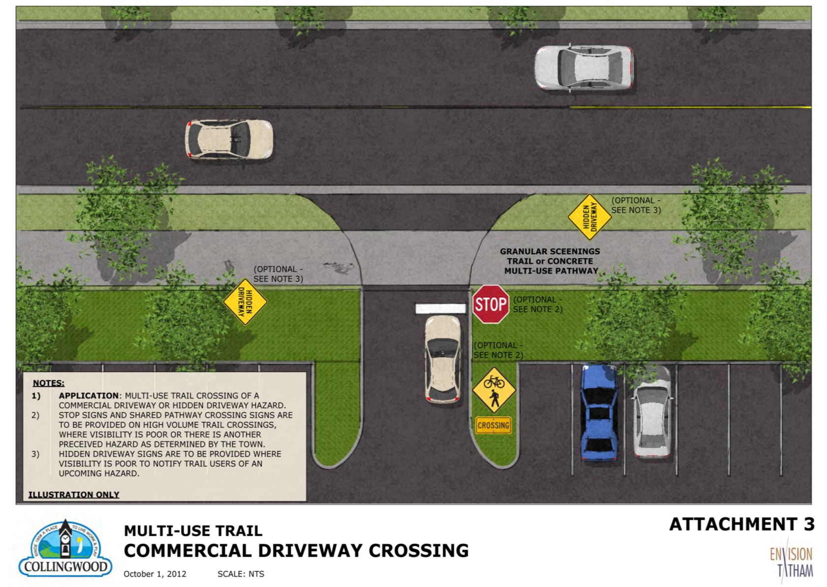
15 Signaled or Signed Intersection Crossing A trail crossing at an identified intersection is optimal and the design phase for each trail should take into consideration crossing at the safest point. When on the road, cyclists are to obey all traffic laws with regards to pedestrian - vehicular right of ways. CROSSING AT A SIGNALED OR SIGNED INTERSECTION CROSSING When a trail crossing occurs at an intersection, road painting is the best way to advise the vehicle about a trail crossing. Private Residential or Commercial Driveway Caution needs to be exercised by the trail user when approaching any unmarked driveway. Busy commercial driveways or those with inadequate sightlines may require appropriate posted warning signs to alert the trail user of an approaching hazard. The illustration in Attachment 3 provides an example of elements that can be applied to a commercial driveway crossing. Not all factors will be required at each crossing as each location will be examined from a site specific manner using design elements from the illustrations. Proper commercial driveway construction allowing for pedestrian traffic first is addressed in the Town Development Standards and Urban Design Manual. For business locations already in existence signage requirements will be addressed on an as-needed basis with the applicable Town Department. SIGNAGE AND ROAD MARKINGS FOR HIGH USE PRIVATE RESIDENTIAL OR COMMERCIAL DRIVEWAY CROSSINGS Vehicles are required by law to come to a complete stop before the painted stop bar at the Stop sign locations. In locations where the recommended sightlines are not achieved for either driver or trail user, signage should be placed to advise the driver / trail user of a trail / driveway crossing ahead. 15

16 16

17 OTHER HAZARD ZONES Hazard zones are places where users can be expected to slow down or stop. Hazard zones include: 1. Unusually busy trail sections 2. Busy intersections with or without directional signs 3. Intersections at the bottom of or along a sustained grade 4. Curves of less than 15 metre radius 5. Blind or near-blind curves 6. Long or interesting bridges where users are likely to stop 7. Boardwalks or other crossings over unusual or special terrain or ecosystems 8. Places with scenic views 9. Places with low side clearance for 5 or more running metres IDENTIFYING OTHER HAZARDS The other hazard zones mentioned above should be mitigated with appropriate warning signage. There may be circumstances where other traffic calming or risk identification features should be considered. MULTI-USE PATHWAYS Multi-use pathways are designed to serve larger volumes and many different types of users simultaneously. They are usually located parallel to the main arterial roads in the more urban parts of town and may also be located in other high traffic areas i.e. Sunset Point Park and High Street. These pathways are meant to act as the arteries of the regional trail network. Since these pathways resemble normal pedestrian sidewalks except for their width (normally 3.0 metres), special signage is needed in high volume areas, to distinguish them from regular pedestrian sidewalks to help regulate the traffic flow of the different users and provide a safe environment for all users. SIGNAGE FOR HARD SURFACE MULTI USE PATHWAYS To accommodate the various types of users travelling at different speeds, appropriate signage will be placed along the trail to remind users of proper etiquette to prevent any conflicts. 17
18 UNAUTHORIZED TRAIL ACTIVITIES Trail standards are developed to support the quality and safety of all approved trail activities. However, in some instances, the standards may not be sufficient to prevent unauthorized use and activities on the trail. There may be circumstances requiring mitigation beyond the standards outlined in this document based on the opinion of Parks, Recreation and Culture staff. The Collingwood Trails Network is designed to be barrier free for the enjoyment of many modes of recreation and active transportation. Motorized vehicles, with the exception of personal mobility assistive devices and maintenance vehicles are not allowed on the trail (Bylaw ). Snowmobiles are allowed on designated trails only (Bylaw ). To reduce any conflicts, there must be a commitment to actively promote the Trails Etiquette and enforcement of applicable Town Bylaws and legislation by all. 18


19 SECTION 5: TRAIL SIGNAGE STANDARDS The recommended standard for advance warning signage is the Bikeway Traffic Control Guidelines for Canada issued by the Transportation Association of Canada or guidelines of the Ministry of Transportation, Ontario Traffic Manual. Regulatory Signs Regulatory signs indicate a traffic regulation that applies at a specific time or place on a road or paved shoulder / bike lane. Disregarding any regulation may result in a violation. These signs are essential to indicate the applicability of legal requirements that may not be otherwise apparent to a motorist or cyclist. Due care must be taken to ensure that these signs are installed whenever needed to fulfill this purpose, but unnecessary signs should be avoided. The Bikeway Traffic Control Guidelines for Canada recommend minimum sign dimensions for regulatory signs where only cyclists and non-motorized users interpret the sign are 300mm (12 ) x 300mm (12 ) square and 300mm (12 ) x 450mm (18 ) rectangle. RA-1 RA-2 RB-94 dismount and walk bike RB-79 Municipal By-law Signage Regulatory signage that is enforceable by the municipality will be posted in locations where a history of unauthorized use is occurring. Locations are chosen based on the quantity of public complaints received or at the discretion of the Town. 19

 x 450mm (18 ).")
20 Warning Signs Warning signs indicate, in advance, conditions on or adjacent to a road or paved shoulder / bike lane that will normally require caution and may require a reduction in speed. Advance warning signs offer a higher level of safety and more efficient traffic flow for motorists and cyclists. The Bikeway Traffic Control Guidelines for Canada recommend minimum sign dimensions for warning signs where only cyclists and non-motorized users interpret the sign are 450mm (18 ) x 450mm (18 ). Warning signs installed on trails are important to advise the trail user of an oncoming hazard and also to remind the user of trail etiquette sharing the trail. 20
21 User Control Signs The signs in this section are used to indicate regulations which prohibit or restrict modes of transportation in a specific area. The signs can also provide guidance for cyclists to indicate the routes which form part of a bicycle route system. User control signs are important to install when multi types of users travel on the same trail. They help to inform the pedestrian that faster travelling cyclists may be sharing the trail with them. Temporary Conditions Signs Temporary condition signs regulate, warn and guide motorists and cyclists in work zones where construction, maintenance or utility activities or other temporary and unusual conditions are on or adjacent to the road and/or paved shoulder / bike lane. The Bikeway Traffic Control Guidelines for Canada recommend minimum sign dimensions for temporary warning signs where only cyclists and non-motorized users interpret the sign are 450mm (18 ) x 450mm (18 ). Pavement Markings Markings on the pavement are a major element for the traffic control of paved shoulder / bike lanes. Well-chosen and well-designed pavement markings provide guidance to motorists and cyclists. Standardization and consistency are essential to provide safe operating conditions. As in the case of all other traffic control devices, markings must be uniform so that they may be easily recognized and understood. Pavement markings are usually designed in accordance with the design standards outlined by Transportation Association of Canada. 21
22 Attachments 1, 2 and 3 provide guidelines for the type of pavement marking required for the type of trail crossing. Paint in the middle of the car travel lane An example of Elephant s Feet Bicycle Crossing Marking Trailhead Trailheads are important entry points that should inform the public about safe trail use. At every major trailhead, a locator board with a map of the network and trail etiquette message should be posted. Other suitable regulatory and way finding signage should also be appropriately located. In locations where parking spaces can be accommodated they will be incorporated to retain the natural feel of the surroundings. 22
23 Trail Access Points, Intersections, Directional / Way finding Points and Remote Area Emergency Signage All trail access points or intersections will be identified with Collingwood Trails Network signage that includes the trail name, directional arrows, distance to other trail intersections and any applicable Municipal By-laws or regulatory signs installed on a 6 x6 post. For trail locations that are not visible from a road, KNOW WHERE YOU ARE signage should be installed with the Town of Collingwood logo, the trail name and a distance marker. This information allows the trail user to relay their location to emergency services for response should an emergency arise. 23
24 SECTION 6: MAINTENANCE STANDARDS TRAIL INSPECTION AND MAINTENANCE Regularly scheduled trail inspections are essential to maintain a safe and viable trail network. Maintenance to be performed on a continuous, regularly basis: a) Trail Inspection Inspections are mandatory to all trail maintenance operations. Inspections should occur on a regularly scheduled basis, checking such items as the condition of railings, bridges, and trail surfaces; proper and adequate signage; removal of debris. The frequency will depend on the amount of trail use, location, age and the type of construction. Inspections should also occur after stormy weather conditions that may possibly cause damage to the trails. b) Trail Grading Trail grading or leveling is an important aspect of trail maintenance to ensure user safety. The type of grading will depend on the trail design and location and may be completed by either machine or in smaller instances by hand. c) Trash Removal The appearance of trash along trail corridors is both unsightly and unsafe for the user. Trash removal should take place on a regularly scheduled basis, the frequency of which will depend on trail use and location. Garbage disposal containers should be provided at all major junctions to allow the user disposal locations. d) Tree and Shrub Pruning A typical trail will require a minimum five (5) metres of horizontal clearance as well as three (3) metres in height clearance (though there will be exceptions for the sake of protecting a tree or skirting around a large boulder). The goal is to maintain the trail in as natural appearance as possible. e) Mowing of Vegetation Vegetation along trail corridors will be mowed on a monthly scheduled basis only where other personnel do not perform mowing. Depending on the characteristic of each individual trail, a minimum of one (1) metre of clearance is required on each side, for user safety. f) Scheduling Maintenance Tasks Inspection and repair priorities should be dictated by trail use, location and design. Scheduling maintenance tasks is a key item toward the goal of consistently clean and safe trails. The role of the Collingwood Trails Network Committee will be to regularly review the quality of trail maintenance and make recommendations for improvements. 24
25 Maintenance to be performed on an as needed basis: a) Trail Repair Repair of asphalt, concrete or limestone base will be closely tied to the inspection schedule. The time between observation and repair of a trail will depend on whether the needed repair is deemed a hazard, whether the needed repair can be performed by the trail maintenance crew or if it is so extensive that it needs to be repaired by outside entities. b) Trail Upgrading The decision to upgrade a trail and the extent of upgrade depends on many factors such as the age of the trail and the money available for replacement. Trail upgrades may involve overlaying a limestone trail with asphalt or concrete. c) Weed Control Weed control along trails will be limited to areas in which certain weeds create a hazard to users, i.e., poison ivy. Chemical weed removal methods shall follow the Ontario s Cosmetic Pesticide Ban. d) Trail Edging Trail edging maintains trail width and improves drainage. Problem areas include trail edges where berms tend to build up and where uphill slopes erode onto the trails. Removal of this material will allow proper draining of the trail surface, allow the flowing action of the water to clean the trail and limit standing water on trail surfaces. e) Trail Drainage Control In places where low spots on the trail catch water, trail surfaces should be raised or drains built to carry away water. Some trail drainage control can be achieved through proper edging of trails taking into consideration the possibility of erosion. f) Re vegetation Areas adjacent to trails that have been disturbed for any reason should be revegetated to minimize erosion. During the building process of new trails, disturbance of the natural environment is inevitable, and should be kept to a minimum. All replacement vegetation should be native to the area and provide habitat, food and shelter for wildlife. g) Habitat Enhancement and Control This is achieved by planting vegetation along trails, mainly low maintenance, native trees and shrubs. This can improve the aesthetics of the trail, help prevent erosion, and provide for wildlife habitat. TRAIL RESURFACING Resurfacing requirements will be documented during the monthly trail inspections and performed on an as needed basis. All granular trails should retain a 100 mm depth of limestone screenings. A crown in the middle of the trail with a 2% slope away from the centre should be maintained to allow for runoff. Vegetation encroaching the sides of the trail should be removed when resurfacing to regain the original width of trail. 25
26 PREVENTATIVE MAINTENANCE CHECKLIST Trail Inspection Worksheet This worksheet is an example of a document to be filled out on a regularly scheduled basis by trail maintenance staff and given to the Department Manager for filing. All hazards should be repaired when found. Any hazards that cannot be completed right away shall be recorded on the accompanying Work Order Request. Trail Name Inspectors Name Date Weather Conditions Time Start Finish Physical Condition of Trail Surface Location of Surface Hazard Horizontal Clearance Location of Hazard Vertical Clearance Location of Hazard Signage Location of Hazard General Comments 26
27 Work Order Request The intent of this document is for repairs required on a trail but maintenance staff do not have the proper equipment to complete the task at that time. This work order request is to be given to the supervisor by the end of the day for scheduling. Date Trail Name Location on Trail Hazard Action taken Name(s) Time Start Time Finish 27
28 APPENDIX A 28
29 29
30 30
31 31
Goals & Objectives. Chapter 9. Transportation
 Goals & Objectives Chapter 9 Transportation Transportation MISSION STATEMENT: TO PROVIDE A TRANSPORTATION NETWORK CAPABLE OF MOVING PEOPLE AND GOODS EFFICIENTLY AND SAFELY. T he transportation system
ENGINEERING SOLUTIONS FOR DESIGNING YOUR SAFE ROUTES
 How to Get Started ENGINEERING SOLUTIONS FOR DESIGNING YOUR SAFE ROUTES Design Elements Selecting appropriate design treatments for school neighborhoods creates environments that address the needs of all
APPENDIX B: TRAIL DEVELOPMENT AND MANAGEMENT STANDARDS
 APPENDIX B: TRAIL DEVELOPMENT AND MANAGEMENT STANDARDS This section provides guidance on a variety of trail issues for planners and developers of the Ice Age NST across the state. It also provides introductory
APPENDIX G. California Coastal Commission & Conservancy Accessibility Standards
 APPENDIX G California Coastal Commission & Conservancy Accessibility Standards STANDARDS AND RECOMMENDATIONS FOR ACCESSWAY LOCATION AND DEVELOPMENT These standards provide guidelines for the location,
APPENDIX F RIGHTS-OF-WAY PRESERVATION GUIDELINES
 Los Angeles County Metropolitan Transportation Authority (Metro) 2009 Transportation Improvement Program Call for Projects APPENDIX F RIGHTS-OF-WAY PRESERVATION GUIDELINES Los Angeles County Metropolitan
How To Improve Safety
 Collision Diagrams Collision diagrams are used to display and identify similar accident patterns. They provide information on the type and number of accidents; including conditions such as time of day,
City of Auburn Americans with Disabilities Act (ADA) Transition Plan for Curb Ramps, Sidewalks, and Pedestrian Signals ADA TRANSITION PLAN
 Transition Plan for Curb Ramps, Sidewalks, and Pedestrian Signals ADA TRANSITION PLAN") Americans with Disabilities Act (ADA) Transition Plan for Curb Ramps, Sidewalks, and Pedestrian Signals ADA TRANSITION PLAN December 21, 2009 Public Works Department 171 N. Ross Street, Suite 200 Auburn,
Americans with Disabilities Act (ADA) Transition Plan for Curb Ramps, Sidewalks, and Pedestrian Signals ADA TRANSITION PLAN December 21, 2009 Public Works Department 171 N. Ross Street, Suite 200 Auburn,
 Walkable Communities Florida Department of Transportation State Safety Office Pedestrian and Bicycle Program April 1995 www.dot.state.fl.us/safety Twelve Steps for an Effective Program Page 1 Twelve Steps
ADA POST INSPECTION CHECKLIST. Job No. Route County Location
 ADA POST INSPECTION CHECKLIST Job No. Route County Location SIDEWALKS All sidewalks constructed within the project limits are ADA compliant. Sidewalks are 5 or greater in width. Exception, existing sidewalks
BEST PRACTICES. Smart Transportation is a key concept for the Paoli Roadway Improvement Project.
 Smart Transportation Smart Transportation is a key concept for the Paoli Roadway Improvement Project. PennDOT s Smart Transportation Guidebook (2008) outlines a comprehensive approach to transportation
28.0 Development Permit Area #2 (Neighbourhood District)
") 28.0 Development Permit Area #2 (Neighbourhood District) Goals and Objectives To provide a guide for infill and new development in the Neighbourhood District. To outline the nature, form and character
28.0 Development Permit Area #2 (Neighbourhood District) Goals and Objectives To provide a guide for infill and new development in the Neighbourhood District. To outline the nature, form and character
Safety Evidence for Bicycling
 Photo: Boegh (Flickr) Cycling in Cities Research Program School of Population & Public Health The University of British Columbia Faculty of Health Sciences Simon Fraser University Driving near bicyclists
Stop The stop sign, a red octagon with white lettering, means come to a full stop and be sure the way is clear before proceeding.
 Tr a f f i c S i g n s 7 7. TRAFFIC SIGNS Many collisions and near crashes occur as a result of drivers who ignore or fail to respond appropriately to traffic signs. It is essential that the meaning of
How To Design A Bicycle Path In California
 HIGHWAY DESIGN MANUAL 1000-1 CHAPTER 1000 BICYCLE TRANSPORTATION DESIGN Topic 1001 - Introduction Index 1001.1 Bicycle Transportation The needs of nonmotorized transportation are an essential part of all
REGIONAL NON-MOTORIZED TRANSPORTATION NETWORK
 Chapter 10 Bicycle and Pedestrian SAFETEA-LU legislation requires that non-motorized users be considered in the LRTP. The legislation allows for bicycle and pedestrian safety to be incorporated into the
DESCRIPTION OF WORK:
 DEPARTMENT OF PUBLIC WORKS COUNTY OF HENRICO P.O. BOX 27032 RICHMOND, VIRGINIA 23273 PERMIT NO. One (1) copy of application and four (4) copies of plans are hereby made to the Director of Public Works
Delineation. Section 4 Longitudinal markings
 Delineation Section 4 Longitudinal markings The delineation guidelines have been developed to assist in designing and maintaining a quality delineation system. The guidelines are to comprise 19 sections
How To Design A Crash Investigation Site
 CHAPTER 7 CRASH INVESTIGATION SITES December, 2000 7. Crash Investigation Sites (CIS) 7.1. Introduction and Usage The idea of "crash investigation sites" or areas outside of the freeway mainline where
ASSET MANAGEMENT GUIDE FOR PROJECT DESIGN FORMAT
 ASSET MANAGEMENT GUIDE FOR PROJECT DESIGN FORMAT 1. BACKGROUND There has been an increasing awareness of design features, which produce poor whole-of-life costs. These poor whole-of-life costs manifest
TEST ON Driving Safely Among Bicyclists and Pedestrians
 TEST ON Driving Safely Among Bicyclists and Pedestrians Next you will take a 16 question test about driving safely among bicyclists and pedestrians. Please take out a sheet of paper to mark down and score
Bicycle riding is a great way to get into shape
 Bicycle riding is a great way to get into shape and have fun. To remain safe on Illinois roads, it is important to follow the same traffic safety laws that govern vehicle drivers. No amount of bicycle
Department of State Development, Infrastructure and Planning. State Planning Policy state interest guideline. State transport infrastructure
 Department of State Development, Infrastructure and Planning State Planning Policy state interest guideline State transport infrastructure July 2014 Great state. Great opportunity. Preface Using this state
How To Know The Laws Of A Bike Ride In California
 The Rules Of The Road For Colorado Cyclists Your Rights and Responsibilities as a Colorado Cyclist Crawford Weiss, LLC Phone (303) 741-0249 www.denversaccidentlawyer.com 2015 The Rules Of The Road For
Chapter Forty-seven. RURAL TWO-LANE/MULTILANE STATE HIGHWAYS (New Construction/Reconstruction) BUREAU OF DESIGN AND ENVIRONMENT MANUAL
 BUREAU OF DESIGN AND ENVIRONMENT MANUAL") Chapter Forty-seven RURAL TWO-LANE/MULTILANE STATE HIGHWAYS (New Construction/Reconstruction) BUREAU OF DESIGN AND ENVIRONMENT MANUAL Illinois RURAL TWO-LANE/MULTILANE STATE HIGHWAYS December 2009 2 Illinois
Chapter Forty-seven RURAL TWO-LANE/MULTILANE STATE HIGHWAYS (New Construction/Reconstruction) BUREAU OF DESIGN AND ENVIRONMENT MANUAL Illinois RURAL TWO-LANE/MULTILANE STATE HIGHWAYS December 2009 2 Illinois
SANTA BARBARA COUNTY COMPREHENSIVE PLAN LOMPOC AREA
 SANTA BARBARA COUNTY COMPREHENSIVE PLAN LOMPOC AREA A. LAND USE ELEMENT INTERPRETIVE GUIDELINES B. COMMUNITY BENEFITS C. COUNTY ACTION ITEMS Adopted by the Board of Supervisors November 9, 1999 A. Santa
Design Guidelines for School Site and Adjacent Lands Planning
 Design Guidelines for School Site and Adjacent Lands ning Halton Technical Stakeholders Sub-Committee May 2011 ------------------------------------------------------- Acknowledgments Halton District School
Bicycle Safety Webinar December 1 st 2010
 Bicycle Safety Webinar December 1 st 2010 Kay Teschke Kay Teschke is Professor in the Schools of Population and Public Health and of Environmental Health at the University of British Columbia. She is principal
Bicycle Safety Quiz Answers Parental Responsibilities
 Bicycle riding is a great way to get into shape and enjoy the outdoors. To remain safe on Illinois roads, it is important to follow the same traffic safety laws that govern vehicle drivers. No amount of
8.1.3 General Design Guidelines. The following guidelines shall be used when designing inlets along a street section:
 . Introduction Presented in this chapter are the criteria and methodology for design and evaluation of storm sewer inlets located in Town of Castle Rock. The review of all planning submittals will be based
Welcome to the future of Terwillegar Park a Unique Natural Park
 Welcome to the future of Terwillegar Park a Unique Natural Park 1 Introduction The Terwillegar Park Concept Plan study will develop an overall concept plan, management objectives and development guidelines
Mayors Welcome Strong Surrey Votes Yes Coalition Support. Yes Vote Would Vastly Improve Transit and Transportation in Fast Growing City
 Mayors Welcome Strong Surrey Votes Yes Coalition Support Yes Vote Would Vastly Improve Transit and Transportation in Fast Growing City February 11, 2015 Vancouver, BC The Mayors Council on Regional Transportation
DESIGN ASSISTANCE APPLICATION
 DESIGN ASSISTANCE APPLICATION for FY 2016 NEW RIVER MULTI USE PATH: PINNACLE PEAK ROAD TO HAPPY VALLEY ROAD CITY OF PEORIA APPLICATIONS ARE DUE VIA ONLINE SUBMITTAL BY 10:00 AM ON MONDAY, JUNE 29, 2015
CITY OF VAUGHAN SCHEDULE O LOT GRADING DESIGN FOR RESIDENTIAL DEVELOPMENT
 Page 1 CITY OF VAUGHAN SCHEDULE O LOT GRADING DESIGN FOR RESIDENTIAL DEVELOPMENT CIVIC CENTRE 2141 MAJOR MACKENZIE DRIVE MAPLE ONTARIO L6A 1T1 905-832-2281 Page 2 SECTION 1 - GENERAL OBJECTIVES To provide
APPENDIX C INLETS. The application and types of storm drainage inlets are presented in detail in this Appendix.
 Storm Drainage 13-C-1 APPENDIX C INLETS 1.0 Introduction The application and types of storm drainage inlets are presented in detail in this Appendix. 2.0 Inlet Locations Inlets are required at locations
Corridor Goals and Objectives
 Corridor Goals and Objectives This chapter presents the goals and objectives, developed by the Corridor Study Committee, that serve as the purpose and intent of the Corridor Plan. This plan covers a twenty
Engineering Standard
 Public Transport Services Engineering Standard Stations - Bicycle Facilities PART 129013 AR-PW-PM-SPE-00129013 (D073) Document Control Document Status Document Amendment Record Revision Change Description
SECTION III-06 Surfacing Page 1 Revised 3/2/10. See the DESIGN GUIDELINES in Section I-06 for requirements for cross slope of the roadway.
 Page 1 Revised 3/2/10 See the DESIGN GUIDELINES in Section I-06 for requirements for cross slope of the roadway. For New/Reconstruction projects: The cross slope of the driving lanes range from 1.5% to
Assessing Paved Trails for Compliance with Standards and Best Practices
 Assessing Paved Trails for Compliance with Standards and Best Practices Session Presenters: Kristin Maravilla, Planner/Designer Masters in Landscape Architecture (UC Berkeley) Masters in City and Regional
1.7.0 Floodplain Modification Criteria
 1.7.0 Floodplain Modification Criteria 1.7.1 Introduction These guidelines set out standards for evaluating and processing proposed modifications of the 100- year floodplain with the following objectives:
Architectural Processing and Inspections for Home Mortgage Insurance
 Page 1 of 5 [Text Only] Architectural Processing and Inspections for Home Mortgage Insurance Directive Number: 4145.1 SITE GRADING AND DRAINAGE GUIDELINES Construction complaints and structural defect
3.1 Historical Considerations
 3. Recommended Scope of Bridge improvements 3.1 Historical Considerations In the fall of 2000, an outside consultant, Fraser Design, suggested that the existing 4 th St. Bridge is potentially eligible
ROAD SAFETY GUIDELINES FOR TAH ROAD INFRASTRUCTURE SAFETY MANAGEMENT
 I. GENERAL ROAD SAFETY GUIDELINES FOR TAH ROAD INFRASTRUCTURE SAFETY MANAGEMENT ANNEX III B i. The setting up and implementing of appropriate management procedures is an essential tool for improving the
Bicycle Safety Enforcement Action Guidelines
 Introduction Bicycle Safety Enforcement Action Guidelines People ride bicycles for many different reasons: fitness, recreation, or for transportation. Regardless of the reason for riding, bicyclists young
CAPACITY AND LEVEL-OF-SERVICE CONCEPTS
 CHAPTER 2 CAPACITY AND LEVEL-OF-SERVICE CONCEPTS CONTENTS I. INTRODUCTION...2-1 II. CAPACITY...2-2 III. DEMAND...2-2 IV. QUALITY AND LEVELS OF SERVICE...2-2 Service Flow Rates...2-3 Performance Measures...2-3
YOUR GUIDE TO INTRA-TOWN CYCLING
 YOUR GUIDE TO INTRA-TOWN CYCLING Content 04 Introduction 05 Attire Before you set off 06 Safety Checklist for Bicycle 07 Maintenance 08 Preventing Bicycle Theft What to look out for on the way 10 Signs
Town of Bellingham DEPARTMENT OF PUBLIC WORKS. Snow and Ice Control FAQs. Q. Can I push snow from my property onto the sidewalk or street?
 Frequently Asked Questions Town of Bellingham DEPARTMENT OF PUBLIC WORKS Snow and Ice Control FAQs Q. Can I push snow from my property onto the sidewalk or street? Bylaw 15.02 restricts this act and you
Clean, Green, Fun! Cady Way. Trail
 Clean, Green, Fun! Cady Way Trail Seminole County Burkett Osceola 426 Mizell Sylvan 426 Ward Memorial Cady Way 436 426 551 Nan Waunatta Martha Mira Pearl George Virginia Berry Irma Winter Pines Golf Course
Development Layout Design
 Development Layout Design General Design Considerations for Adoptable Highways Version 1 June 2012 Transportation, Waste and Environment Service Issue and Revisions Record Revision Date Originator Purpose
Now Therefore, The Corporation of the City of Peterborough by the Council thereof hereby enacts as follows:
 The Corporation of the City of Peterborough By-Law Number 14-096 Being a By-law to Regulate Bicycles, Skateboards, Inline Skates, Roller Skates, E- bikes, Segways and other conveyances drawn, propelled
DOÑA ANA COUNTY DESIGN STORM CRITERIA GUIDELINES FOR COMMERCIAL AND RESIDENTIAL SITES. Run-off Analysis Methods
 DOÑA ANA COUNTY DESIGN STORM CRITERIA GUIDELINES FOR COMMERCIAL AND RESIDENTIAL SITES Run-off Analysis Methods This document sets forth the minimum design, technical criteria and specifications for the
Topic 2 11/28/2012 Blocks & Street Network
 TOPIC 2 Blocks & Street Network Implementation Note: 1. Some recommendations are summarized in the tables herein. For complete recommendation language, please see the. 2. Recommendations referenced in
CHAPTER 2 TRAFFIC SIGNS AND HIGHWAY MARKINGS
 CHAPTER 2 TRAFFIC SIGNS AND HIGHWAY MARKINGS This chapter summarizes traffic signs, signals and road markings that control the flow of traffic, making streets and highways safer for motorists, bicyclists
Alternatives to the Circ Project Prioritization Methodology Prepared for Circ Task Force July 28, 2011
 Alternatives to the Circ Project Prioritization Methodology Prepared for Circ Task Force July 28, 2011 CCRPC staff has developed a draft methodology described below and detailed in the attached pages for
B. Improve the appearance and character of areas surrounding new development.
 Chapter 4.3: Landscape Regulations Sections: 4.301 Purposes 4.302 Applicability 4.303 General Provisions 4.304 Landscape Maintenance 4.301 Purposes The purposes of these regulations are to: A. Promote
SECTION 02100 SITE PREPARATION
 SECTION 02100 SITE PREPARATION PART 1 - GENERAL 1.01 RELATED DOCUMENTS A. Drawings and General Provisions of Contract, including General Conditions and Supplementary Conditions and Division 1 through Division
- FREE! - The Official San Francisco BIKE GUIDE. 1st Edition
 - FREE! - The Official San Francisco BIKE GUIDE 1st Edition SF BIKE LAWS SAN FRANCISCO BICYCLISTS MUST: Yield to People Walking Whether they re in a crosswalk or not, ALWAYS yield to people walking. Stop
AGENCY COORDINATION AND PUBLIC INVOLVEMENT
 5 AGENCY COORDINATION AND PUBLIC INVOLVEMENT 5.1 AGENCY COORDINATION As part of the planning process for the Oregon Avenue Final EA, DDOT conducted an agency coordination program. This coordination included
BICYCLE AND IN-LINE SKATE LAWS ROAD SHARING RESPONSIBILITIES OF BICYCLISTS AND MOTORISTS, REQUIRED EQUIPMENT AND PARENTAL RESPONSIBILITY
 BICYCLE AND IN-LINE SKATE LAWS ROAD SHARING RESPONSIBILITIES OF BICYCLISTS AND MOTORISTS, REQUIRED EQUIPMENT AND PARENTAL RESPONSIBILITY The statutes in this material have been generated from the database
OVERVIEW PROJECT SUMMARY
 OVERVIEW Cesar Chavez showcases how to successfully redesign a primary arterial route into a neighborhood destination, improving modal share, water sensitive design, biodiversity and safety whilst maintaining
Rockhampton Office Brisbane Office Tarong Site. Barron Gorge Hydro PS Kareeya Hydro PS Mica Creek PS
 Business Procedure Traffic Management Document Number OHS-PROC-130 This document applies to the following sites: All Sites Rockhampton Office Brisbane Office Tarong Site Barron Gorge Hydro PS Kareeya Hydro
Guelph Driving School. 246 WOOLWICH ST. Unit C Guelph, Ontario N1H 3V9. Office: 519-829-8801 Cell: 519-362-5664. Email: info@guelphdrivingschool.
 246 WOOLWICH ST. Unit C Guelph, Ontario N1H 3V9 Office: 519-829-8801 Cell: 519-362-5664 Email: [email protected] Dear Student, We would like to take this opportunity to thank you for choosing
PUBLIC INFORMATIONAL MEETING THURSDAY APRIL 30, 2015
 PUBLIC INFORMATIONAL MEETING THURSDAY APRIL 30, 2015 AT ACTON TOWN HALL FAULKNER ROOM 472 MAIN STREET ACTON, MASSACHUSETTS 7:00 PM FOR THE PROPOSED ASSABET RIVER RAIL TRAIL (ARRT) IN THE TOWNS OF ACTON
Lincoln Downtown Master Plan Update
 Lincoln Downtown Master Plan Update Table of Contents Executive Summary........................................... 1 Complete Streets Framework.................................... 3 Promenade Creating
SAFE CYCLING GUIDE. 7th Edition
 SAFE CYCLING GUIDE 7th Edition BEFORE SETTING OUT A Check tire pressure B Check that the chain does not slip C Check the brakes D Check lights and reflectors: 1 A WELL-MAINTAINED BICYCLE is key 3 4 5 Adjust
A Guide to Safe Bicycling in Hawai i
 A Guide to Safe Bicycling in Hawai i Sharing the Road: A Guide to Safe Bicycling in Hawai i What Motorists & Bicyclists Should Know Everyone has the right to be safe on Hawai i s roads. Law of the Splintered
These "rules of the road" are based on Texas Transportation Code statutes. Find the complete bicycle code at the bottom of the page
 Texas Bicycle Laws These "rules of the road" are based on Texas Transportation Code statutes. Find the complete bicycle code at the bottom of the page Bicyclists have the rights and duties of other vehicle
MICHIGAN S LANDSCAPE ARCHITECTS
 MICHIGAN S LANDSCAPE ARCHITECTS protecting the health, safety, and welfare of our citizens site design land use planning master planning streetscape design brownfield redevelopment guidelines and regulations
SAFE CYCLING GUIDE. 6th Edition
 SAFE CYCLING GUIDE 6th Edition BEFORE SETTING OUT A WELL-MAINTAINED BICYCLE is key A Check tire pressure B Check that the chain does not slip C Check the brakes D Check lights and reflectors: 3 4 1 5 2
THE REGIONAL MUNICIPALITY OF NIAGARA BY-LAW NO. 122-2013 SIGN BY-LAW
 THE REGIONAL MUNICIPALITY OF NIAGARA BY-LAW NO. 122-2013 SIGN BY-LAW WHEREAS Section 11 of the Municipal Act, 2001, S.O. 2001, c. 25, authorizes the Regional Municipality of Niagara to pass by-laws respecting
Walking Route the assigned or authorized route a pupil walks to arrive at school or at the designated bus stop.
 BUSINESS NON-INSTRUCTION OPERATION 3541 TRANSPORTATION I. GENERAL It is the goal of the Board of Education to establish for the public schools an appropriate transportation system one which will enable
NASHVILLE BICYCLE LAW 3/18/09
 NASHVILLE BICYCLE LAW 3/18/09 12.60.010 Compliance with Title 12 provisions. It is unlawful for any person to do any act prohibited or fail to perform any act required by Title 12 of this code. (Prior
Best Practice For Selecting Bus Stop Locations
 Best Practice For Selecting Bus Stop Locations There is no perfect school bus stop, because it is impossible to eliminate all potential hazards, but guidelines and training are still necessary to ensure
Atlanta, Georgia Road Test
 1. When driving your car Into traffic from a parked position, you should: A. Sound your horn and pull Into the other lane. B. Signal and proceed when safe. C. Signal other traffic and pull directly into
SAN DIEGO - A BICYCLE FRIENDLY CITY
 SAN DIEGO - A BICYCLE FRIENDLY CITY MANY OPPORTUNITIES FOR IMPROVEMENT SUMMARY The designated bicycle paths and lanes in the City of San Diego (City) are often substandard because of their location and
City of Kelowna Traffic Management Guide. December 2010
 City of Kelowna Traffic Management Guide December 2010 City of Kelowna Traffic Management Guide December 2010 Prepared by: Urban Systems Ltd. 304-1353 Ellis Street Kelowna, BC V1Y 1Z9 T: (250) 762-2517
(As amended by By-law 68-2014) By-law 78-91 of The Corporation of the City of Oshawa
 By-law 78-91 of The Corporation of the City of Oshawa") (As amended by By-law 68-2014) By-law 78-91 of The Corporation of the City of Oshawa being a by-law to regulate and control the use of skateboards, bicycles and similar devices within the City of Oshawa.
(As amended by By-law 68-2014) By-law 78-91 of The Corporation of the City of Oshawa being a by-law to regulate and control the use of skateboards, bicycles and similar devices within the City of Oshawa.
CHAPTER 3A Environmental Guidelines for STREAM CROSSING BY ALL-TERRAIN VEHICLES
 GOVERNMENT OF NEWFOUNDLAND AND LABRADOR DEPARTMENT OF ENVIRONMENT AND LABOUR CHAPTER 3A Environmental Guidelines for STREAM CROSSING BY ALL-TERRAIN VEHICLES WATER RESOURCES MANAGEMENT DIVISION Water Investigations
PEDESTRIAN LAWS OF NORTH CAROLINA
 PEDESTRIAN LAWS OF NORTH CAROLINA Under North Carolina law, pedestrians have the right of way at all intersections and driveways. However, pedestrians must act responsibly, using pedestrian signals where
Woodlands Management Plan. (Draft June 2011) A. Definition of Woodlands Areas vs. Landscaped Areas of Parkfairfax
 A. Definition of Woodlands Areas vs. Landscaped Areas of Parkfairfax") Woodlands Management Plan (Draft June 2011) I. Background A. Definition of Woodlands Areas vs. Landscaped Areas of Parkfairfax The woodlands are defined as those wooded areas of Parkfairfax which are left
Woodlands Management Plan (Draft June 2011) I. Background A. Definition of Woodlands Areas vs. Landscaped Areas of Parkfairfax The woodlands are defined as those wooded areas of Parkfairfax which are left
Town of Creston. Bylaw No. 1813
 Town of Creston Bylaw No. 1813 A Bylaw relating to the care and maintenance of private property and adjoining public places within the Town of Creston. WHEREAS Sections 62 and 64 of the Community Charter
KENTUCKY TRANSPORTATION CABINET. Department of Rural and Municipal Aid. Office of Local Programs
 KENTUCKY TRANSPORTATION CABINET Department of Rural and Municipal Aid Office of Local Programs Office of Local Programs Transportation Enhancements Safe Routes to School Congestion Mitigation and Air Quality
Pedestrian & Bicycle Roadway Design Safe, Smart and Defendable
 Pedestrian & Bicycle Roadway Design Safe, Smart and Defendable Josh DeBruyn Bicycle and Pedestrian Coord. Michigan Dept. of Transportation Ronald W. Emery Transportation Division Dept. of Attorney General
Revised January 2015. Bicycle Policy & Design Guidelines Maryland State Highway Administration
 Revised January 2015 Bicycle Policy & Design Guidelines Maryland State Highway Administration RECORD OF CHANGES TO THE MAY 2013 BICYCLE POLICY & DESIGN GUIDELINES Introduction The 2013 Bicycle Policy &
WESTFIELD-WASHINGTON ADVISORY PLAN COMMISSION December 7, 2015 1512-SPP-24 & 1512-ODP-24
 Petition Number: Subject Site Address: Petitioner: Request: East side of Oak Road, north of 151 st Street Langston Development Co. Primary Plat and Overall Development Plan amendment review for Mapleridge
New York Bicycling Pocket Guide
 New York Bicycling Pocket Guide Prepared by the New York Bicycling Coalition About This Guide Getting around by bike is good for one s health and wallet, and the environment. But many people aren t sure
Road Signs Recognition Quiz
 Road Signs Recognition Quiz Place your answer for each of the signs/pavement markings on the answer sheet. Ready to Roll? Here Comes Sign # 1... #1 A No right turn B Right turn only C Warning, no turn
PLANNED UNIT DEVELOPMENT & SIDEWALK WAIVER REQUEST STAFF REPORT Date: November 7, 2013
 PLANNED UNIT DEVELOPMENT & SIDEWALK WAIVER REQUEST STAFF REPORT Date: November 7, 2013 NAME LOCATION Audubon Properties, LLC. 4700 & 4960 Dauphin Island Parkway West side of Dauphin Island Parkway, 580
ENGINEERING DESIGN GUIDELINES. for SUBDIVISIONS OR COMMERCIAL DEVELOPMENTS
 ENGINEERING DESIGN GUIDELINES for SUBDIVISIONS OR COMMERCIAL DEVELOPMENTS City of Birmingham Department of Planning, Engineering and Permits Engineering Division Office of the City Engineer 2008 TABLE
Bike Laws: Massachusetts
 Bike Laws: Massachusetts Do you know your rights of the road? Do you know what your responsibilities are when biking in Massachusetts? Here is a summary of Massachusetts bike law that covers equipment,
Interlocking Concrete Pavement Institute (ICPI) Model Stormwater Ordinance for Permeable Interlocking Concrete Pavements August 2010
 Model Stormwater Ordinance for Permeable Interlocking Concrete Pavements August 2010") Interlocking Concrete Pavement Institute (ICPI) Model Stormwater Ordinance for Permeable Interlocking Concrete Pavements August 2010 Background What are permeable interlocking concrete pavements (PICP)?
Interlocking Concrete Pavement Institute (ICPI) Model Stormwater Ordinance for Permeable Interlocking Concrete Pavements August 2010 Background What are permeable interlocking concrete pavements (PICP)?
NEZ PERCE-CLEARWATER FORESTS
 United States Department of Agriculture Forest Service NEZ PERCE-CLEARWATER FORESTS Fish Creek Meadows A Year-Round Playground For Idaho and the Northwest Fish Creek Meadows Year-round Recreation For Everyone
Document Name: Driving Skills. Purpose: To outline necessary driving skills required to maximize driving safety.
 Document Name: Driving Skills Date Created: 8 October 2013 Date Reviewed: 4 February 2014 Date Approved: 29 July 2015 Purpose: To outline necessary driving skills required to maximize driving safety. Overview:
MOBILE HOME LAW. Revised November 2001
 MOBILE HOME LAW Revised November 2001 TABLE OF CONTENTS: SECTION 1: SECTION 2: SECTION 3: SECTION 4: SECTION 5: SECTION 6: SECTION 7: SECTION 8: SECTION 9: SECTION 10: SECTION 11: SECTION 12: INTENT DEFINITIONS