Ruimtelijke planning in tijden van klimaatsverandering
|
|
|
- Cora Randall
- 10 years ago
- Views:
Transcription
1 Ruimtelijke planning in tijden van klimaatsverandering Eric Koomen Vrije Universiteit Amsterdam/ Geodan Next Nascholingscursus Water, rivieren en GIS' 3 april 2008

2 Outline Climate change climate and land use interact perspective and projections Adapting spatial planning mitigation and adaptation dealing with uncertainties (LANDS project) flood risk management (AVV project) Conclusion GIS and spatial analysis
 flood risk management (AVV project) Conclusion GIS")
3 Climate and land-use interact (US CCSP, 2004)

4 Climate and land-use interact Land use (human activity) influences: atmospheric composition (emission/fixation) terrestrial radiation Climate change influences land use: coastal zones (sea level rise) river basins (flood/drought) agricultural production (volume/type) natural vegetation (ecosystems)
 agricultural production (volume/type) natural vegetation")
5 Perspective Geological perspective:

6 Perspective Regional variation:

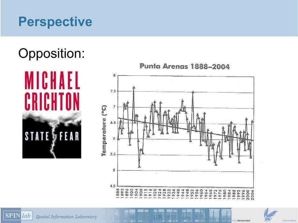
7 Perspective Opposition:
8 Perspective Consensus of thousands of scientists: human influence 'very likely' temperature increases degrees / 100 jr sea level rises cm, or more possibly more wind and precipitation

9 Projections Future scenarios:

10 Projections: sea level rise may increase cm in 2100

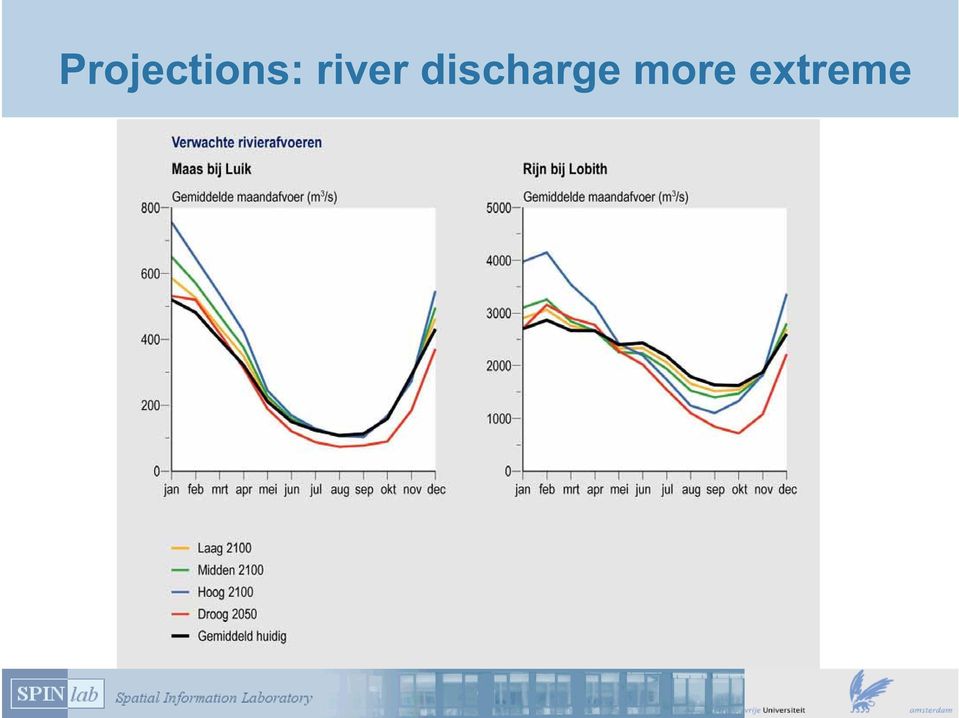
11 Projections: river discharge more extreme
12 Projections: precipitation more diverse +1 deg. C (2050) +2 deg. C (2050) G G+ W W+ Precipat. summer Precipat. winter Evapor. Summer

13 Projections: precipitation more extreme More often, more extreme, e.g.:

14 Projections Soil subsidence:

15 Planning: mitigation Limiting climate change calls for drastic communal action 50-60% emissie reductie!

16 Planning: adaptation Cope with projected changes: water management retention areas safe construction adapt sewage system coastal defence adapt spatial policies (i.e. Ecological Main Structure, urbanisation) changes in agricultural sector?

17 Hot research topic Various studies (see also: Aandacht voor Veiligheid (RWS, Attention for Safety) focus on water safety in 2050/2100 Adaptation program Ruimte en Klimaat (Space and Climate, 4 departments) integral measures Climate for Space ( Klimaat voor Ruimte, knowledge institutes involved) Nederland Later (MNP, Netherlands later) exploring possible spatial consequences
 www.klimaatvoorruimte.")
18 Downscaling global change: LANDS Designing national land-use adaptation and mitigation strategies under changing climate conditions Many partners, interdisciplinary, large and long-lasting: Government-funded project in 'Climate changes spatial planning' program that consists of over 30 projects

19 LANDS - objectives developing a consistent scenario-framework delivering baseline outlooks for 2040: integrated land use, adaptations for nature, water en urban functions to be added later integrating sector-specific adaptation measures from other projects improving the model: 100m version, calibration/validation, visualisation, indicators, conflict analysis, data-infrastructure

20 LANDS - overview 4 Conflict/ opportunity indicators KNMI scenarios LANDS scenarios Land Use Scanner Land Use simulations WLO scenarios Sector (e.g. water) 7 start of new run Sector models and analysis 5 Claims and/or suitability maps 6 LANDS Supplying projects Sector (e.g. nature) Sector models and analysis 5 Claims and/or suitability maps 6 Sector (e.g. agriculture ) Sector models and analysis Claims and/or suitability maps 5 6 Subsidiary projects
 Sector models and analysis 5 Claims and/or suitability maps 6 Sector (e.g. agriculture ) Sector models and analysis Claims and/or suitability maps 5 6 Subsidiary projects")
21 LANDS - scenarios Quantitative assumptions regarding climate, population, economy and society are combined from KNMI and WLO
22 LANDS - scenarios Socio-economic changes are even more difficult to asses than climatic changes
23 LANDS - Land Use Scanner Model that simulates future land use for preparation and ex-ante evaluation of policy reports Typical applications: scenario analysis trend analysis impact assessment
24 LANDS - model characteristics an operational information system for land-use planning since 1997 GIS based (100m or 500m grid) integrated (all types of land use) exhaustive (full country) satellite structure (external claims) cross-sectional (static approach) policy oriented (applied science) two approaches (logit and optimisation) economic analogy (balances supply and demand)
25 LANDS - model layout
26 Initial land-use simulations
27 Sector-specific adaptation measures Several projects are now working on the development of adaptation strategies, e.g. workshops on water management: creative sessions, but a challenge to incorporate results in subsequent simulations
28 Sector-specific adaptation measures
29 Sector-specific adaptation measures agriculture project- LEI Land use 2050 without pumping regional case study energy crops Friesland uses A1, W+ scenarios Land Use Scanner needs upscaling to national level
30 AVV (safety first) - building a DSS
31 AVV - project layout Users Socioeconomic scenarios Climate change scenarios Strategy Investment moment Effect indicators Costs & Benefits Evaluation Global economy Regional Communities Sea-level rise (cm/ year) River discharge m 3 /sec Coastal summer Precipitation (mm) Do nothing Business As Usual Dwelling mound Flood probability Potential damage Potential number of victims Risk (probability * damage) Cost & Benefits far future Multi Criteria Analysis Surge (m) Spatial planning Graphics symbology: Choice window Variable Pre-set Output Feedback
32 AVV - safety strategies Terpen, islands or extended coastline:
33 AVV - integrated strategies
34 AVV - evaluating flood risk Risk = probability * damage = ( flood frequency * water depth * damage function ) aggregate Damage (Meuro) 0.60 * wonen_stedelijk wonen_groen_stedelijk wonen_landelijk recreatie werken zeehavens natuur akkerbouw = > Depth (m)
35 AVV - comparing strategies
36 Conclusion GIS in our case: storage and manipulation of spatial data spatial analysis spatial modelling presentation of results
37 Further reading Many publications available from: (click LANDS) or
It s hard to avoid the word green these days.
 Going green : Environmental jobs for scientists and engineers Alice Ramey Alice Ramey is an economist in the Office of Occupational Statistics and Employment Projections, BLS. She is available at (202)
CLIMATE CHANGE AND NATURE,
 CLIMATE CHANGE AND NATURE, INTEGRATION OF SPATIAL POLICIES WITH A LAND USE MODEL Michiel van Eupen 1, Eveliene Steingröver 1, Sabine van Rooij 1 Eric Koomen 2 & Chris jacobs 2 Rotterdam 29 September 2010
Origins and causes of river basin sediment degradation and available remediation and mitigation options. Feedback from the Riskbase workshop
 Origins and causes of river basin sediment degradation and available remediation and mitigation options Feedback from the Riskbase workshop Corinne Merly 1, Olivier Cerdan 1, Laurence Gourcy 1 Emmanuelle
Damage Assessment in a large River Basin The Mekong Experience. Phan Nguyen& Anthony Green Mekong River Commission
 Damage Assessment in a large River Basin The Mekong Experience Phan Nguyen& Anthony Green Mekong River Commission Contents 1. Features and vulnerabilities 2. Influence of Changing Climate 3. Damage Assessment
THE STRATEGIC PLAN OF THE HYDROMETEOROLOGICAL PREDICTION CENTER
 THE STRATEGIC PLAN OF THE HYDROMETEOROLOGICAL PREDICTION CENTER FISCAL YEARS 2012 2016 INTRODUCTION Over the next ten years, the National Weather Service (NWS) of the National Oceanic and Atmospheric Administration
II. Related Activities
 (1) Global Cloud Resolving Model Simulations toward Numerical Weather Forecasting in the Tropics (FY2005-2010) (2) Scale Interaction and Large-Scale Variation of the Ocean Circulation (FY2006-2011) (3)
Preliminary advances in Climate Risk Management in China Meteorological Administration
 Preliminary advances in Climate Risk Management in China Meteorological Administration Gao Ge Guayaquil,Ecuador, Oct.2011 Contents China Framework of Climate Service Experience in Climate/disaster risk
Climate-proofing freshwater supply in the Netherlands
 Climate-proofing freshwater supply in the Netherlands ECCA 2013 20 februari 2013 Ron Franken, Jelle van Minnen, Willem Ligtvoet 1 Climate-proofing freshwater supply in the Netherlands Leading questions
Climate Ready Tools & Resources
 August 2, 2013 Mission Statement To provide the water sector (drinking water, wastewater, and stormwater utilities) with the practical tools, training, and technical assistance needed to adapt to climate
SOUTH EAST EUROPE TRANSNATIONAL CO-OPERATION PROGRAMME
 SOUTH EAST EUROPE TRANSNATIONAL CO-OPERATION PROGRAMME 3 rd Call for Proposals Terms of reference Climate Change Adaptation: assessing vulnerabilities and risks and translating them to implementation actions
Belmont Forum Collaborative Research Action on Mountains as Sentinels of Change
 Belmont Forum Collaborative Research Action on Mountains as Sentinels of Change 1. Background and rationale Mountains exist in many regions of the world and are home to a significant fraction of the world
Advanced tools in water management in The Netherlands
 Advanced tools in water management in The Netherlands Modelling for system knowledge, effective operational management, and policy making Gé van den Eertwegh Rivierenland Water Board The Netherlands PR
CCI-HYDR Perturbation Tool. A climate change tool for generating perturbed time series for the Belgian climate MANUAL, JANUARY 2009
 CCI-HYDR project (contract SD/CP/03A) for: Programme SSD «Science for a Sustainable Development» MANUAL, JANUARY 2009 CCI-HYDR Perturbation Tool A climate change tool for generating perturbed time series
Climate change impacts on city of Gdansk and its vicinity (Vistula Delta, Poland)
") Final International ASTRA Conference Espoo, 10-11 December, 2007 Climate change impacts on city of Gdansk and its vicinity (Vistula Delta, Poland) Dorota Kaulbarsz, Zbigniew Kordalski, Wojciech Jeglinski
Final International ASTRA Conference Espoo, 10-11 December, 2007 Climate change impacts on city of Gdansk and its vicinity (Vistula Delta, Poland) Dorota Kaulbarsz, Zbigniew Kordalski, Wojciech Jeglinski
Climate Change Impacts in the Asia/Pacific Region
 Climate Change Impacts in the Asia/Pacific Region Global CC threat CC in the A/P region The Stern Review and IPCC 4 th Assessment Report both state that climate change will have adverse impact on people
The Dutch Delta Approach
 Sweden Mission from Skane The Dutch Delta Approach Future proof flood risk management in the Netherlands Martien Beek Special advisor to Delta Program Commissioner 18 September 2013 1 The Netherlands exposure
sample The IPCC Special Report on Managing the Risks of Extreme Events and Disasters to Advance Climate Change Adaptation
 sample The IPCC Special Report on Managing the Risks of Extreme Events and Disasters to Advance Climate Change Adaptation A changing climate leads to changes in extreme weather and climate events 2 Impacts
Why Demographic Data are not Up to the Challenge of Measuring Climate Risks, and What to do about it. CIESIN Columbia University
 UN Conference on Climate Change and Official Statistics Oslo, Norway, 14-16 April 2008 Why Demographic Data are not Up to the Challenge of Measuring Climate Risks, and What to do about it CIESIN Columbia
CIESIN Columbia University
 Conference on Climate Change and Official Statistics Oslo, Norway, 14-16 April 2008 The Role of Spatial Data Infrastructure in Integrating Climate Change Information with a Focus on Monitoring Observed
Climate Change Long Term Trends and their Implications for Emergency Management August 2011
 Climate Change Long Term Trends and their Implications for Emergency Management August 2011 Overview A significant amount of existing research indicates that the world s climate is changing. Emergency
Climate Extremes Research: Recent Findings and New Direc8ons
 Climate Extremes Research: Recent Findings and New Direc8ons Kenneth Kunkel NOAA Cooperative Institute for Climate and Satellites North Carolina State University and National Climatic Data Center h#p://assessment.globalchange.gov
Precipitation Monitoring Network:
 The Caribbean Drought and Precipitation Monitoring Network: Adrian R. Trotman Caribbean Institute for Meteorology and Hydrology CARIWIN Regional Seminar 14-15 January, 2010 Georgetown, Guyana Why Plan
How To Use The Climate Ready Utilities Program
 Introduction to the Climate Resilience Evaluation & Awareness Tool Climate Ready Water Utilities Webinar Series Curt Baranowski, US EPA Jim Hawhee, Albemarle-Pamlico NEP February 27, 2013 Use your mouse
The IPCC Special Report on Managing the Risks of Extreme Events and Disasters to Advance Climate Change Adaptation
 The IPCC Special Report on Managing the Risks of Extreme Events and Disasters to Advance Climate Change Adaptation A changing climate leads to changes in extreme weather and climate events 2 How do changes
APPENDIX A : 1998 Survey of Proprietary Risk Assessment Systems
 APPENDIX A : 1998 Survey of Proprietary Risk Assessment Systems In its 1997 paper, the working party reported upon a survey of proprietary risk assessment systems designed for use by UK household insurers
California Future Water Demand Projections (WEAP Model): Implications on Energy Demand
: Implications on Energy Demand") California Future Water Demand Projections (WEAP Model): Implications on Energy Demand Dr. Mohammad Rayej California Department of Water Resources Sacramento, California, U.S.A. Water Energy Conference
California Future Water Demand Projections (WEAP Model): Implications on Energy Demand Dr. Mohammad Rayej California Department of Water Resources Sacramento, California, U.S.A. Water Energy Conference
G3-Giornate Giovani GNRAC Quartiere Fieristico di Ferrara, 21 Settembre 2012
 3 SALONE SULLA TUTELA DELLA COSTA COAST PROTECTION EXHIBITION 2 ND EDITION G3-Giornate Giovani GNRAC Quartiere Fieristico di Coastal vulnerability assessment to climate change. CVI Index application to
Estimating Potential Reduction Flood Benefits of Restored Wetlands
 Estimating Potential Reduction Flood Benefits of Restored Wetlands Kenneth W. Potter University of Wisconsin Introduction Throughout the summer of 1993 a recurring question was the impact of wetland drainage
Climate Change on the Prairie:
 Climate Change on the Prairie: A Basic Guide to Climate Change in the High Plains Region - UPDATE Global Climate Change Why does the climate change? The Earth s climate has changed throughout history and
New challenges of water resources management: Title the future role of CHy
 New challenges of water resources management: Title the future role of CHy by Bruce Stewart* Karl Hofius in his article in this issue of the Bulletin entitled Evolving role of WMO in hydrology and water
EC-Earth: new global earth system model
 EC-Earth: new global earth system model Wilco Hazeleger Vincent v Gogh Global Climate Division/EC-Earth program KNMI, The Netherlands Amsterdam, December 2008 1 Amsterdam, December 2008 2 Observed climate
Creating a More Resilient Future. Friday 30 May, 11:00 to 12:30, Rooms S29-31
 Creating a More Resilient Future Friday 30 May, 11:00 to 12:30, Rooms S29-31 Empowering Resilience With GIS ICLEI Smart Resilient Cities Strategic Use of Spatial Systems Jim Geringer, Esri Former Governor,
Asia-Pacific Environmental Innovation Strategy (APEIS)
") Asia-Pacific Environmental Innovation Strategy (APEIS) Integrated Environmental Monitoring IEM) Dust Storm Over-cultivation Desertification Urbanization Floods Deforestation Masataka WATANABE, National
Asia-Pacific Environmental Innovation Strategy (APEIS) Integrated Environmental Monitoring IEM) Dust Storm Over-cultivation Desertification Urbanization Floods Deforestation Masataka WATANABE, National
Climate vulnerability assessment Risks from urban flooding Interactive science and policy assessment
 Climate vulnerability assessment Risks from urban flooding Interactive science and policy assessment Flood risk from extreme precipitation in Copenhagen - Modelling results Per Skougaard Kaspersen, DTU
Martine Jak 1 and Matthijs Kok 2
 A DATABASE OF HISTORICAL FLOOD EVENTS IN THE NETHERLANDS Martine Jak 1 and Matthijs Kok 2 1 Department of Transport, Public works and Water Management Road and Hydraulic Engineering Division P.O. Box 5044
A Decision Support System (DSS) for Integrated Water Resources Management WEAP- MODFLOW DSS. K. Schelkes et al., BGR Hannover
 for Integrated Water Resources Management WEAP- MODFLOW DSS. K. Schelkes et al., BGR Hannover") A Decision Support System (DSS) for Integrated Water Resources Management WEAP- MODFLOW DSS K. Schelkes et al., BGR Hannover Outline Introduction WEAP Software developments Pilot study Zabadani Examples
A Decision Support System (DSS) for Integrated Water Resources Management WEAP- MODFLOW DSS K. Schelkes et al., BGR Hannover Outline Introduction WEAP Software developments Pilot study Zabadani Examples
Operational methodology to assess flood damages in Europe
 IIASA-DPRI 2008 Operational methodology to assess flood damages in Europe Contributors: Nicola Lugeri, Carlo Lavalle, Elisabetta Genovese 1 Focus of ADAM work on extremes Types Floods, Heat-wave, Drought
Tools from the US EPA s Climate Ready Water Utilities Initiative (CRWU) EPA Region 3 Conference Extreme Weather Events: Adapt, Mitigate, and Survive
 EPA Region 3 Conference Extreme Weather Events: Adapt, Mitigate, and Survive") Tools from the US EPA s Climate Ready Water Utilities Initiative (CRWU) EPA Region 3 Conference Extreme Weather Events: Adapt, Mitigate, and Survive May 9, 2013 1 Presentation Overview Background on EPA
Tools from the US EPA s Climate Ready Water Utilities Initiative (CRWU) EPA Region 3 Conference Extreme Weather Events: Adapt, Mitigate, and Survive May 9, 2013 1 Presentation Overview Background on EPA
Climate Change Adaptation Good Practice - Case Study. Climate Futures for Tasmania
 Climate Change Adaptation Good Practice - Case Study Climate Futures for Tasmania About Adaptation Good Practice Adapting to climate change is a relatively new concept to many. It is important to learn
Flood damage assessment and estimation of flood resilience indexes
 Flood damage assessment and estimation of flood resilience indexes Barcelona case study Marc Velasco CETaqua Workshop CORFU Barcelona Flood resilience in urban areas the CORFU project Cornellà de Llobregat,
Master of Science (MSc) in Water Resources Engineering
 in Water Resources Engineering") Master of Science (MSc) in Water Resources Engineering Water Resources Engineering Water Resources Engineering deals with the methods and techniques applied in the study of: water needs for agriculture,
Master of Science (MSc) in Water Resources Engineering Water Resources Engineering Water Resources Engineering deals with the methods and techniques applied in the study of: water needs for agriculture,
Climate Change and Infrastructure Planning Ahead
 Climate Change and Infrastructure Planning Ahead Climate Change and Infrastructure Planning Ahead Infrastructure the physical facilities that support our society, such as buildings, roads, railways, ports
Argonne National Laboratory
 Argonne National Laboratory Using Climate Data to Inform Critical Infrastructure Resilience and Urban Sustainability Decisionmaking National Academy of Sciences Roundtable on Science and Technology for
Water Management in the Netherlands
 Water Management in the Netherlands Eric Boessenkool Senior Advisor to the Management Board of RIjkswaterstaat Ministry of Infrastructure and the Environment New ministry since end of 2010 Merger of Ministry
EUROPEAN COMMISSION. Better Regulation "Toolbox" This Toolbox complements the Better Regulation Guideline presented in in SWD(2015) 111
 111") EUROPEAN COMMISSION Better Regulation "Toolbox" This Toolbox complements the Better Regulation Guideline presented in in SWD(2015) 111 It is presented here in the form of a single document and structured
EUROPEAN COMMISSION Better Regulation "Toolbox" This Toolbox complements the Better Regulation Guideline presented in in SWD(2015) 111 It is presented here in the form of a single document and structured
How To Calculate Flood Damage Potential In European Landscape
 Background/Introduction RISK ANALYSIS MODULE 3, CASE STUDY 2 Flood Damage Potential at European Scale By Dr. Peter Burek There is good reason to be concerned about the growth of flood losses in Europe.
Guideline for Stress Testing the Climate Resilience of Urban Areas
 Netherlands Ministry of Infrastructure and Environment Delta Programme Urban Development and Reconstruction Guideline for Stress Testing the Climate Resilience of Urban Areas Extended summary Version 1.0
climate science A SHORT GUIDE TO This is a short summary of a detailed discussion of climate change science.
 A SHORT GUIDE TO climate science This is a short summary of a detailed discussion of climate change science. For more information and to view the full report, visit royalsociety.org/policy/climate-change
WHAT DOES CLIMATE CHANGE MEAN FOR YOUR LOCAL AREA?
 WHAT DOES CLIMATE CHANGE MEAN FOR YOUR LOCAL AREA? THE FEDERAL ELECTORATE OF MARIBYRNONG The Climate Council is an independent, crowd-funded organisation providing quality information on climate change
Rural Flooding: The Potential Role of Forestry
 Rural Flooding: The Potential Role of Forestry Nadeem Shah, Tom Nisbet, & Huw Thomas Centre for Forestry and Climate Change Structure Background Woodland and Flood Alleviation The Theory. Studies on Woodland
3D VISUALISATIONS IN SIMULATIONS OF FUTURE LAND USE: EXPLORING THE POSSIBILITIES OF NEW, STANDARD VISUALISATION TOOLS
 3D VISUALISATIONS IN SIMULATIONS OF FUTURE LAND USE: EXPLORING THE POSSIBILITIES OF NEW, STANDARD VISUALISATION TOOLS J. Rodríguez a, N. Omtzigt b, E. Koomen b, F. S. de Blois c a SIGTE, Servei de Sistemes
Development in land consolidation in The Netherlands. Experiences. Kees van der Vaart DLG Service for Land and Water Management
 Development in land consolidation in The Netherlands Experiences Kees van der Vaart DLG Service for Land and Water Management The Netherlands Land consolidation not/never finished A lecture with pictures
An Outlook on the Euro-Mediterranean Centre for Climate Change CMCC
 An Outlook on the Euro-Mediterranean Centre for Climate Change CMCC Introduction to CMCC CMCC is the Italian Research Centre on Climate Science and Policy. Supported by the Italian Ministry for the Environment
HAZARD RISK ASSESSMENT, MONITORING, MAINTENANCE AND MANAGEMENT SYSTEM (HAMMS) FOR LANDSLIDE AND FLOOD. Mohd. Nor Desa, Rohayu and Lariyah, UNITEN
 FOR LANDSLIDE AND FLOOD. Mohd. Nor Desa, Rohayu and Lariyah, UNITEN") HAZARD RISK ASSESSMENT, MONITORING, MAINTENANCE AND MANAGEMENT SYSTEM (HAMMS) FOR LANDSLIDE AND FLOOD Mohd. Nor Desa, Rohayu and Lariyah, UNITEN WHAT WE HAVE IN MIND AND FROM OUR PREVIOUS PROJECT CONTRIBUTION
HAZARD RISK ASSESSMENT, MONITORING, MAINTENANCE AND MANAGEMENT SYSTEM (HAMMS) FOR LANDSLIDE AND FLOOD Mohd. Nor Desa, Rohayu and Lariyah, UNITEN WHAT WE HAVE IN MIND AND FROM OUR PREVIOUS PROJECT CONTRIBUTION
CUBA CONFRONTING CLIMATE CHANGE
 CUBA CONFRONTING CLIMATE CHANGE CUBA: Main Characteristics Total population: 11.2 millions Length of the Island of Cuba: 1,200 Km. Maximum Width: 191 Km. Minimum Width: 31 Km. More than 4,000 islands and
Title: Guiding Models and Norm Study for Water Storage: A new way of thinking?
 Tools Title: Guiding Models and Norm Study for Water Storage: A new way of thinking? Keywords: Regional; communication; inundation; stakeholder engagement; water management; spatial planning Audience:
Country overview and assessment
 2. BULGARIA This country fiche provides a comprehensive overview and assessment of climate change adaptation in Bulgaria. After detailing the vulnerability of Bulgaria s coastal zones, the responsibility
Overview of NASA Applied Remote Sensing Training Program on Water Resources and Disaster Management
 Overview of NASA Applied Remote Sensing Training Program on Water Resources and Disaster Management ARSET Applied Remote SEnsing Training A project of NASA Applied Sciences Outline About ARSET ARSET Trainings
Basic Climatological Station Metadata Current status. Metadata compiled: 30 JAN 2008. Synoptic Network, Reference Climate Stations
 Station: CAPE OTWAY LIGHTHOUSE Bureau of Meteorology station number: Bureau of Meteorology district name: West Coast State: VIC World Meteorological Organization number: Identification: YCTY Basic Climatological
Integrated Global Carbon Observations. Beverly Law Prof. Global Change Forest Science Science Chair, AmeriFlux Network Oregon State University
 Integrated Global Carbon Observations Beverly Law Prof. Global Change Forest Science Science Chair, AmeriFlux Network Oregon State University Total Anthropogenic Emissions 2008 Total Anthropogenic CO 2
chapter 9 conduct a climate change
 CONDUCT A CLIMATE RESILIENCY STUDY The following chapters recommend how to reach CRC Milestone Two, Conduct a Climate Resiliency Study. 2 MILESTONE Chapter 8: Conduct a Climate Change Vulnerability Assessment
Applying MIKE SHE to define the influence of rewetting on floods in Flanders
 Applying MIKE SHE to define the influence of rewetting on floods in Flanders MARK HENRY RUBARENZYA 1, PATRICK WILLEMS 2, JEAN BERLAMONT 3, & JAN FEYEN 4 1,2,3 Hydraulics Laboratory, Department of Civil
GCE. Geography. Mark Scheme for June 2011. Advanced Subsidiary GCE Unit F761: Managing Physical Environments. Oxford Cambridge and RSA Examinations
 GCE Geography Advanced Subsidiary GCE Unit F761: Managing Physical Environments Mark Scheme for June 2011 Oxford Cambridge and RSA Examinations OCR (Oxford Cambridge and RSA) is a leading UK awarding body,
Lecture Series in Water, Soil and Atmosphere (315.340) Unit 1: Interaction Soil / Vegetation / Atmosphere
 Unit 1: Interaction Soil / Vegetation / Atmosphere") Dept. Water, Soil & Atmosphere Institute of Hydraulics and Rural Water Management University of Natural Resources and Life Sciences Vienna Lecture Series in Water, Soil and Atmosphere (315.340) Unit 1:
Dept. Water, Soil & Atmosphere Institute of Hydraulics and Rural Water Management University of Natural Resources and Life Sciences Vienna Lecture Series in Water, Soil and Atmosphere (315.340) Unit 1:
REDUCING UNCERTAINTY IN SOLAR ENERGY ESTIMATES
 REDUCING UNCERTAINTY IN SOLAR ENERGY ESTIMATES Mitigating Energy Risk through On-Site Monitoring Marie Schnitzer, Vice President of Consulting Services Christopher Thuman, Senior Meteorologist Peter Johnson,
Climate change and increased risk for the insurance sector: a global perspective and an assessment for the Netherlands
 Nat Hazards (2010) 52:577 598 DOI 10.1007/s11069-009-9404-1 ORIGINAL PAPER Climate change and increased risk for the insurance sector: a global perspective and an assessment for the Netherlands W. J. W.
Water Management in Cuba: Problems, Perspectives, Challenges and the Role of the Cuban Academy of Sciences
 Water Management in Cuba: Problems, Perspectives, Challenges and the Role of the Cuban Academy of Sciences Daniela M. Arellano Acosta Environment Agency/ Water Commission, Academy of Science, CUBA Water
Water Demand Forecast Approach
 CHAPTER 6 2009 REGIONAL WATER SUPPLY OUTLOOK Water Demand Forecast Approach 6.1 Introduction Long-range water demand forecasting is a fundamental tool that water utilities use to assure that they can meet
ERP: Willamette-Ecosystem Services Project
 ERP: Willamette-Ecosystem Services Project Presented by Iris Goodman to NAS Sustainability R&D Forum October 17-18, 2007 Conserving ecosystem services through proactive decision-making making Linking Human
Geothermal. . To reduce the CO 2 emissions a lot of effort is put in the development of large scale application of sustainable energy.
 Geothermal Energy With increasing fossil fuel prices, geothermal energy is an attractive alternative energy source for district heating and industrial heating. In recent years the use of geothermal energy
MONITORING OF DROUGHT ON THE CHMI WEBSITE
 MONITORING OF DROUGHT ON THE CHMI WEBSITE Richterová D. 1, 2, Kohut M. 3 1 Department of Applied and Land scape Ecology, Faculty of Agronomy, Mendel University in Brno, Zemedelska 1, 613 00 Brno, Czech
Geographical Information Systems with Remote Sensing
 SCHOOL OF SCIENCE Geographical Information Systems with Remote Sensing PGDip/MSc Medway Campus www.gre.ac.uk/science Why study this programme? Geographical Information Systems (GIS) and Remote Sensing
specification AS/A Level GCE GCE Geography version 4 September 2013 OCR Advanced Subsidiary GCE in Geography H083 OCR Advanced GCE in Geography H483
 AS/A Level GCE GCE Geography OCR Advanced Subsidiary GCE in Geography H083 OCR Advanced GCE in Geography H483 version 4 September 2013 specification OCR 2013 QAN 500/2613/6 QAN 500/2585/5 Contents 1 About
REGIONAL CLIMATE AND DOWNSCALING
 REGIONAL CLIMATE AND DOWNSCALING Regional Climate Modelling at the Hungarian Meteorological Service ANDRÁS HORÁNYI (horanyi( [email protected]@met.hu) Special thanks: : Gabriella Csima,, Péter Szabó, Gabriella
THE NAIROBI WORK PROGRAMME ON IMPACTS, VULNERABILITY AND ADAPTATION TO CLIMATE CHANGE UNFCCC THE NINE WORK AREAS OF THE NAIROBI WORK PROGRAMME
 ON IMPACTS, VULNERABILITY AND ADAPTATION TO CLIMATE CHANGE 1 METHODS AND TOOLS WHAT IS? The Nairobi work programme, under the United Nations Framework Convention on Climate Change (), aims to assist countries
Climate Futures Evaluation and Synthesis Tool
 Climate Futures Evaluation and Synthesis Tool September 2015 Alexander Epstein, Ben Rasmussen, and Chris Cutler The National Transportation Systems Center Advancing transportation innovation for the public
How To Assess The Vulnerability Of The Neman River To Climate Change
 Management of the Neman River basin with account of adaptation to climate change Progress of the pilot project since February, 2011 Vladimir Korneev, Central Research Institute for Complex Use of Water
Master of Science in Geography
 Master of Science in Geography Specializations: Earth and Climate City, Society and Space GIS and Spatial Modelling INTERUNIVERSITY PROGRAMME Faculty of Science The Master of Science in Geography is a
Global environmental information Examples of EIS Data sets and applications
 METIER Graduate Training Course n 2 Montpellier - february 2007 Information Management in Environmental Sciences Global environmental information Examples of EIS Data sets and applications Global datasets
Risk and vulnerability assessment of the build environment in a dynamic changing society
 Risk and vulnerability assessment of the build environment in a dynamic changing society Limnei Nie SINTEF Building and infrastructure, P.O.Box 124 Blindern, NO-0314 Oslo, Norway. [email protected]
2015 Global Risk Assessment. Sahar Safaie Program Officer, UNISDR Risk Knowledge Section
 2015 Global Risk Assessment Sahar Safaie Program Officer, UNISDR Risk Knowledge Section Outline Global Assessment Report (GAR) evolution Global Risk Assessment for GAR15 Objective Scope Audience/Users
Standardized Runoff Index (SRI)
") Standardized Runoff Index (SRI) Adolfo Mérida Abril Javier Gras Treviño Contents 1. About the SRI SRI in the world Methodology 2. Comments made in Athens on SRI factsheet 3. Last modifications of the factsheet
Standardized Runoff Index (SRI) Adolfo Mérida Abril Javier Gras Treviño Contents 1. About the SRI SRI in the world Methodology 2. Comments made in Athens on SRI factsheet 3. Last modifications of the factsheet
Hydrological transport modeling
 Hydrological transport modeling Catchment modeling example from the EU EUROCAT project Catchment - river - coast continuum modeling example from MONERIS modeling Sea-air exchange modeling example from