3D Object Digitalization Project: Digital Langweil s model of Prague. Visual Connection, a.s
|
|
|
- Lynne Stafford
- 10 years ago
- Views:
Transcription
1 3D Object Digitalization
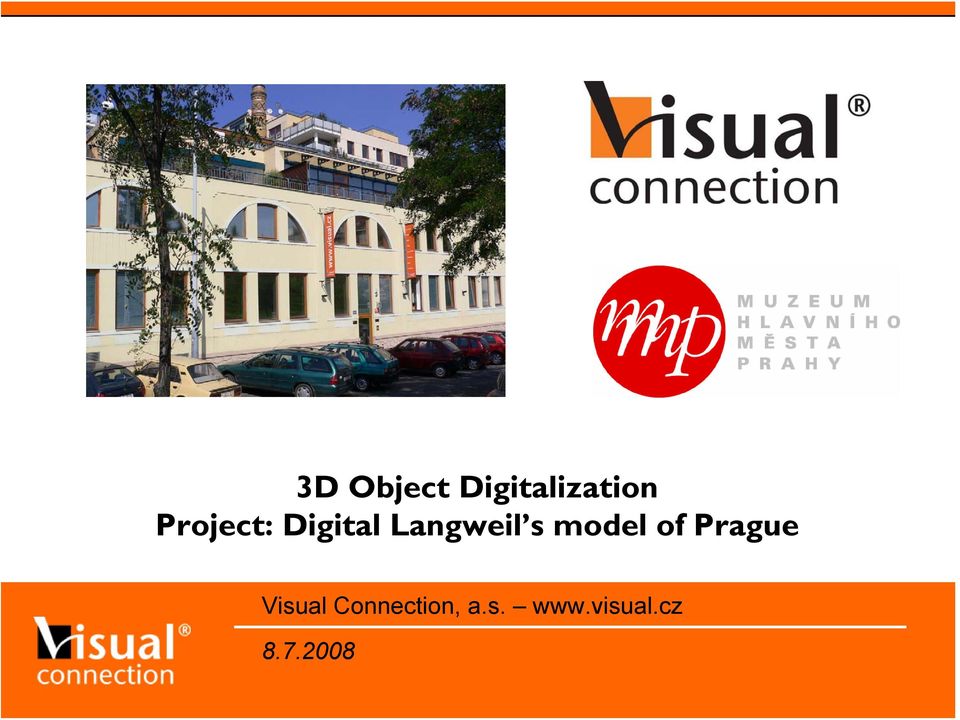
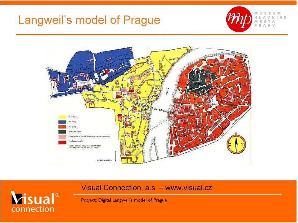
2 Langweil s model of Prague This realistic, paper model of Prague, named after its creator, shows more than two thousand buildings in the city's historic centre in detail, and covers an area of some 20 m 2. In its size, technical mastery and excellent artistic expression it is one of the most spell-binding works ever made by human hand. Realistic paper model of Prague More than 2000 buildings of historical Prague center First time presented to public in 1862 Model scale 1:480 One of the most detail urbanistic paper models in the world The model geometrically corresponds to real status of today s historical center 90% of model is made from the paper and wood Model surface 20 m 2 divided into 52 separate parts

3 Langweil s model of Prague

4 Langweil s model of Prague
5 Langweil s model of Prague 3,5m ~ 1,6km 6m ~ 2,6km

6 Ing. Jan Buriánek,

7 Ing. Jan Buriánek,

8 Ing. Jan Buriánek,

9 Ing. Jan Buriánek,

10 Ing. Jan Buriánek,

11 Ing. Jan Buriánek,

12 Ing. Jan Buriánek,

13 Ing. Jan Buriánek,

14 Ing. Jan Buriánek,

15 Ing. Jan Buriánek,

16

17 Project objectives Main objectives of Digital Langweil s Model: Digital archive of physical model Exhaustive detailed map of the model ( GIS ) Availability to experts and scientists Today s and historical Prague comparison Many public applications of the model: Multimedia CD/DVD about the model Digital presentation of the model at exhibitions Interactive applications (games, )

18 Project DLM Digital Langweil s Model of Prague (DLM): Public tender (2006) Project stages: Preparation / analysis Systematic capturing 3D model reconstruction Experts Application (GIS/GIS3D) Applications for public Public release of the project: Q4 / 2008
 Applications for public Public release of the")
19 Models difficulties Why is digitalization process of the model extremely difficult? Extreme details in both geometry and textures ~ macro Internal resolution of textures is ~ 1200 DPI Langweil was miniaturist, i.e. 3x3 mm signs on the walls (house orientation signs) Small letters on cemetery stones Statues on the Charles bridge Lamps on the walls St. Vitus Cathedral Average height of a house ~ 6,5 cm Very narrow streets (~ 3 mm) Painted arcades Jan Buriánek, Visual Connection, a.s.
 Small letters on cemetery stones Statues on the Charles bridge Lamps")
20 Models resolution 10 lpi ~ 300 DPI 20 lpi ~ 600 DPI 40 lpi ~ 1200 DPI Expected during Minimum needed Optimal 16x more project preparation data and processing then expected Jan Buriánek, Visual Connection, a.s.

21 Data acquisition process systematic capture Special capturing photo robot
22 Data acquisition process systematic capture Special measurement procedures 3D scanning - Just for very complex geometry of the Cathedral Laparoscopic camera - Narrow streets etc. Professional photo camera - Frontal views - Full-frame camera
23 Data acquisition process systematic capture Output data (first stage of the project): More than calibrated pictures - 16Mpix digital photos - 13-bit per RGB channel Calibration measurement - Color reference - Scale reference Full project data database and documentary More than 6TB data
24 3D model reconstruction
25 3D model reconstruction
26 3D model reconstruction
27 3D model reconstruction
28 3D model reconstruction 3D point-cloud Millions reference 3D points Prezentace průběžných výsledků projektu
29 3D model reconstruction 3D point-cloud Prezentace průběžných výsledků projektu
30 3D model reconstruction 3D point-cloud Prezentace průběžných výsledků projektu
31 3D model reconstruction 3D point-cloud Prezentace průběžných výsledků projektu
32 3D model reconstruction 3D point-cloud Prezentace průběžných výsledků projektu
33 3D model reconstruction - polygonal model Projekt: Digitalizace Langweilova modelu Prahy
34 3D model reconstruction textured model Projekt: Digitalizace Langweilova modelu Prahy
35 3D model reconstruction complex model Projekt: Digitalizace Langweilova modelu Prahy
36 3D model reconstruction - complex model Projekt: Digitalizace Langweilova modelu Prahy
37 3D model reconstruction special geometry Special data set St. Vitus Cathedral (LASER scan) The most complex object in the model. 3D LASER scanner measurement. More than 6 millions of points (3D point-cloud). More than 6 millions triangles.
38 3D model reconstruction special geometry Special data set St. Vitus Cathedral (LASER scan & texture extraction) Projekt: Digitalizace Langweilova modelu Prahy
39 3D model reconstruction special geometry Special data set Charles bridge (special technology for statues)
40 Selected statistic data 3D object statistics The model contains: roofs chimneys trees Polygonal model consists: >40 millions of 3D points >50 millions of 3D polygons roughly 1 TB of texture data
41 Project outputs Expert application / output Special computer application for experts High-end visualization workstations for 3D digital model Very special system for 2D and 3D model view Database access via GIS (3D) methodology Knowledge base of the model Virtual 3D measurement tool Comparison: today s and historical Prague
42 Project outputs Expert application user interface Prezentace průběžných výsledků projektu
43 Project outputs Computer applications for public DVD Video about the project ( Making of ) Internet pages about the project (including some videos etc.) 3D model presentation CD (DVD) Virtual tours around 3D Langweil s model of Prague Technology: VRML97 Interactive 3D presentation on CD/DVD Škola hrou / Edutainment interactive game Quiz, adventure game, Public launch of the project: Q4/2008!
44 Project outputs Simplified model for public applications Prezentace průběžných výsledků projektu
45 Project outputs Ukázka z aplikace pro veřejnost Prezentace průběžných výsledků projektu
46 Project outputs Interactive game application sample Prezentace průběžných výsledků projektu
47 General notes for 3D projects General issues of 3D digitalization Extreme limitations during data acquisition process Very difficult budget planning (especially time planning) No standard for making 3D digital model. Various output forms required. The most stable digital medium has 30 years guarantee, no more
48 Thank you for attention! Visual Connection, a.s. Slezská 113/ Praha 3 Contact: [email protected]
Self-Positioning Handheld 3D Scanner
 Self-Positioning Handheld 3D Scanner Method Sheet: How to scan in Color and prep for Post Processing ZScan: Version 3.0 Last modified: 03/13/2009 POWERED BY Background theory The ZScanner 700CX was built
VERSATILE AND EASY-TO-USE 3D LASER SCANNERS > >
 VERSATILE AND EASY-TO-USE 3D LASER SCANNERS > > A WORLD OF APPLICATIONS Z Corporation, producers of the industry s fastest, easiest-to-use and most versatile 3D scanners, makes 3D scanning ideal for a
VERSATILE AND EASY-TO-USE 3D LASER SCANNERS > >
 VERSATILE AND EASY-TO-USE 3D LASER SCANNERS > > A WORLD OF APPLICATIONS 3D Systems, producers of the industry s fastest, easiest-to-use and most versatile 3D scanners, makes 3D scanning ideal for a wide
A technical overview of the Fuel3D system.
 A technical overview of the Fuel3D system. Contents Introduction 3 How does Fuel3D actually work? 4 Photometric imaging for high-resolution surface detail 4 Optical localization to track movement during
3D MODELING OF LARGE AND COMPLEX SITE USING MULTI-SENSOR INTEGRATION AND MULTI-RESOLUTION DATA
 3D MODELING OF LARGE AND COMPLEX SITE USING MULTI-SENSOR INTEGRATION AND MULTI-RESOLUTION DATA G. Guidi 1, F. Remondino 2, 3, M. Russo 1, F. Menna 4, A. Rizzi 3 1 Dept.INDACO, Politecnico of Milano, Italy
Understanding Resolution and the meaning of DPI, PPI, SPI, & LPI
 Understanding Resolution and the meaning of DPI, PPI, SPI, & LPI 2003, 2006, and 2012 David Creamer I.D.E.A.S. Publishing Consultant & Trainer Authorized Adobe Training Provider for Photoshop, Illustrator,
Optical Digitizing by ATOS for Press Parts and Tools
 Optical Digitizing by ATOS for Press Parts and Tools Konstantin Galanulis, Carsten Reich, Jan Thesing, Detlef Winter GOM Gesellschaft für Optische Messtechnik mbh, Mittelweg 7, 38106 Braunschweig, Germany
3D Model of the City Using LiDAR and Visualization of Flood in Three-Dimension
 3D Model of the City Using LiDAR and Visualization of Flood in Three-Dimension R.Queen Suraajini, Department of Civil Engineering, College of Engineering Guindy, Anna University, India, [email protected]
How To Use Bodescan For 3D Imaging Of The Human Body
 «Bodescan» THE ULTIMATE 3D SCANNER FOR DATA ACQUISITION OF HUMAN BODY A COMPREHENSIVE SYSTEM INCLUDING HARDWARE AND SOFTWARE TOOLS Page 2 of 9 Bodescan HUMAN BODY3D SCANNING HARDWARE AND SOFTWARE INCLUDED
MassArt Studio Foundation: Visual Language Digital Media Cookbook, Fall 2013
 INPUT OUTPUT 08 / IMAGE QUALITY & VIEWING In this section we will cover common image file formats you are likely to come across and examine image quality in terms of resolution and bit depth. We will cover
DIABLO VALLEY COLLEGE CATALOG 2015-2016
 ART DIGITAL MEDIA ARTDM Michael Almaguer, Dean Applied and Fine Arts Division Business and Foreign Language Building, Room 204 Possible career opportunities Digital media or graphic design jobs cover all
HIGH AND LOW RESOLUTION TEXTURED MODELS OF COMPLEX ARCHITECTURAL SURFACES
 HIGH AND LOW RESOLUTION TEXTURED MODELS OF COMPLEX ARCHITECTURAL SURFACES E. K. Stathopoulou a, A. Valanis a, J. L. Lerma b, A. Georgopoulos a a Laboratory of Photogrammetry, National Technical University
BUILDING TELEPRESENCE SYSTEMS: Translating Science Fiction Ideas into Reality
 BUILDING TELEPRESENCE SYSTEMS: Translating Science Fiction Ideas into Reality Henry Fuchs University of North Carolina at Chapel Hill (USA) and NSF Science and Technology Center for Computer Graphics and
XXI International CIPA Symposium, 01-06 October, Athens, Greece
 2 DIFFERENT TECHNIQUES OF SCANNING CULTURAL HERITAGE 1. CLOSE-RANGE-SCANNING OF 250 CLAYFIGURINES IN XIAN, CHINA 2. LASER-SCANNING OF 3.200 DINOSAUR-STEPS IN SUCRE, BOLIVIA Stefan Linsinger a Dipl.-Ing.
Pictorial User s Guide
 S-T IMAGING Pictorial User s Guide Copyright 2008 ST Imaging, Inc. a division of Digital Check Corp. All Rights Reserved. Table of Contents Getting Started... 1 Adjust for Viewing...1 Loading Microfilm...2
ZEISS T-SCAN Automated / COMET Automated 3D Digitizing - Laserscanning / Fringe Projection Automated solutions for efficient 3D data capture
 ZEISS T-SCAN Automated / COMET Automated 3D Digitizing - Laserscanning / Fringe Projection Automated solutions for efficient 3D data capture ZEISS 3D Digitizing Automated solutions for efficient 3D data
Introduction to Computer Graphics. Jürgen P. Schulze, Ph.D. University of California, San Diego Fall Quarter 2012
 CSE 167: Introduction to Computer Graphics Jürgen P. Schulze, Ph.D. University of California, San Diego Fall Quarter 2012 Today Course organization Course overview 2 Course Staff Instructor Jürgen Schulze,
Introduction to Computer Graphics
 Introduction to Computer Graphics Torsten Möller TASC 8021 778-782-2215 [email protected] www.cs.sfu.ca/~torsten Today What is computer graphics? Contents of this course Syllabus Overview of course topics
3D Building Roof Extraction From LiDAR Data
 3D Building Roof Extraction From LiDAR Data Amit A. Kokje Susan Jones NSG- NZ Outline LiDAR: Basics LiDAR Feature Extraction (Features and Limitations) LiDAR Roof extraction (Workflow, parameters, results)
Geometry - Calculating Area and Perimeter
 Geometry - Calculating Area and Perimeter In order to complete any of mechanical trades assessments, you will need to memorize certain formulas. These are listed below: (The formulas for circle geometry
The Flat Shape Everything around us is shaped
 The Flat Shape Everything around us is shaped The shape is the external appearance of the bodies of nature: Objects, animals, buildings, humans. Each form has certain qualities that distinguish it from
Consolidated Visualization of Enormous 3D Scan Point Clouds with Scanopy
 Consolidated Visualization of Enormous 3D Scan Point Clouds with Scanopy Claus SCHEIBLAUER 1 / Michael PREGESBAUER 2 1 Institute of Computer Graphics and Algorithms, Vienna University of Technology, Austria
DIABLO VALLEY COLLEGE CATALOG 2014-2015
 ART DIGITAL MEDIA ARTDM Michael Almaguer, Dean Applied and Fine Arts Division Business and Foreign Language Building, Room 204 Possible career opportunities Digital media or graphic design jobs cover all
FREQUENTLY ASKED QUESTIONS
 C FREQUENTLY ASKED QUESTIONS 1 [Q] What is the MakerBot Digitizer [A] The MakerBot Digitizer Desktop 3D Scanner quickly turns the things in your world into 3D models that you can modify, improve, share,
Graphic Design. Location: Patterson Campus - Bldg. K. Program Information. Occupational Choices. Average Full-Time Wage.
 Graphic Design 178 Graphic Design Location: Patterson Campus - Bldg. K Program Information Graphic Design is a vital component of the communications people receive each day. Personal, professional, business,
Differentiation of 3D scanners and their positioning method when applied to pipeline integrity
 11th European Conference on Non-Destructive Testing (ECNDT 2014), October 6-10, 2014, Prague, Czech Republic More Info at Open Access Database www.ndt.net/?id=16317 Differentiation of 3D scanners and their
3D Scanner using Line Laser. 1. Introduction. 2. Theory
 . Introduction 3D Scanner using Line Laser Di Lu Electrical, Computer, and Systems Engineering Rensselaer Polytechnic Institute The goal of 3D reconstruction is to recover the 3D properties of a geometric
STATE OF THE ART OF THE METHODS FOR STATIC 3D SCANNING OF PARTIAL OR FULL HUMAN BODY
 STATE OF THE ART OF THE METHODS FOR STATIC 3D SCANNING OF PARTIAL OR FULL HUMAN BODY Dr. Nicola D Apuzzo N. D Apuzzo, 14.6.06 1 Contents of presentation Introduction on 3D human body digitization Measurement
How To Fuse A Point Cloud With A Laser And Image Data From A Pointcloud
 REAL TIME 3D FUSION OF IMAGERY AND MOBILE LIDAR Paul Mrstik, Vice President Technology Kresimir Kusevic, R&D Engineer Terrapoint Inc. 140-1 Antares Dr. Ottawa, Ontario K2E 8C4 Canada [email protected]
3D City Modelling of Istanbul Historic Peninsula by Combination of Aerial Images and Terrestrial Laser Scanning Data
 4th EARSel Workshop on Remote Sensing for Developing Countries/GISDECO 8, Istanbul, Turkey, June 4-7, 2008 3D City Modelling of Istanbul Historic Peninsula by Combination of Aerial Images and Terrestrial
Files Used in this Tutorial
 Generate Point Clouds Tutorial This tutorial shows how to generate point clouds from IKONOS satellite stereo imagery. You will view the point clouds in the ENVI LiDAR Viewer. The estimated time to complete
IP-S2 HD. High Definition 3D Mobile Mapping System
 IP-S2 HD High Definition 3D Mobile Mapping System Integrated, turnkey solution High Density, Long Range LiDAR sensor for ultimate in visual detail High Accuracy IMU and DMI Odometry for positional accuracy
IP-S3 HD1. Compact, High-Density 3D Mobile Mapping System
 IP-S3 HD1 Compact, High-Density 3D Mobile Mapping System Integrated, turnkey solution Ultra-compact design Multiple lasers minimize scanning shades Unparalleled ease-of-use No user calibration required
IP-S2 Compact+ 3D Mobile Mapping System
 IP-S2 Compact+ 3D Mobile Mapping System 3D scanning of road and roadside features Delivers high density point clouds and 360 spherical imagery High accuracy IMU options without export control Simple Map,
3D Face Modeling. Vuong Le. IFP group, Beckman Institute University of Illinois ECE417 Spring 2013
 3D Face Modeling Vuong Le IFP group, Beckman Institute University of Illinois ECE417 Spring 2013 Contents Motivation 3D facial geometry modeling 3D facial geometry acquisition 3D facial deformation modeling
Information Contents of High Resolution Satellite Images
 Information Contents of High Resolution Satellite Images H. Topan, G. Büyüksalih Zonguldak Karelmas University K. Jacobsen University of Hannover, Germany Keywords: satellite images, mapping, resolution,
Proposal for a Virtual 3D World Map
 Proposal for a Virtual 3D World Map Kostas Terzidis University of California at Los Angeles School of Arts and Architecture Los Angeles CA 90095-1467 ABSTRACT The development of a VRML scheme of a 3D world
EPSON SCANNING TIPS AND TROUBLESHOOTING GUIDE Epson Perfection 3170 Scanner
 EPSON SCANNING TIPS AND TROUBLESHOOTING GUIDE Epson Perfection 3170 Scanner SELECT A SUITABLE RESOLUTION The best scanning resolution depends on the purpose of the scan. When you specify a high resolution,
Digital Image Basics. Introduction. Pixels and Bitmaps. Written by Jonathan Sachs Copyright 1996-1999 Digital Light & Color
 Written by Jonathan Sachs Copyright 1996-1999 Digital Light & Color Introduction When using digital equipment to capture, store, modify and view photographic images, they must first be converted to a set
INTRODUCTION TO DIGITAL PHOTOGRAPHY
 INTRODUCTION TO DIGITAL PHOTOGRAPHY Description Digital Photography will explore electronic imaging through the use of digital cameras, scanners and printers. This course will cover basic technical information
New Features in TerraPhoto. Arttu Soininen Software developer Terrasolid Ltd
 New Features in TerraPhoto Arttu Soininen Software developer Terrasolid Ltd Export City Model Improvements Roof slope setting determines what polygons will be treated as walls and what as roofs Write roofs
Calculating Area, Perimeter and Volume
 Calculating Area, Perimeter and Volume You will be given a formula table to complete your math assessment; however, we strongly recommend that you memorize the following formulae which will be used regularly
Art Educators, For more information contact Brenda Gregory at 813-215-8906 OR email Brenda Gregory at [email protected].
 Art Educators, My name is Brenda Gregory and I am working directly with the Florida State Fair Art Portfolio for High School Seniors contest. We have implemented some major changes this year to make it
Robot Perception Continued
 Robot Perception Continued 1 Visual Perception Visual Odometry Reconstruction Recognition CS 685 11 Range Sensing strategies Active range sensors Ultrasound Laser range sensor Slides adopted from Siegwart
The process components and related data characteristics addressed in this document are:
 TM Tech Notes Certainty 3D November 1, 2012 To: General Release From: Ted Knaak Certainty 3D, LLC Re: Structural Wall Monitoring (#1017) rev: A Introduction TopoDOT offers several tools designed specifically
PHOTOGRAMMETRIC TECHNIQUES FOR MEASUREMENTS IN WOODWORKING INDUSTRY
 PHOTOGRAMMETRIC TECHNIQUES FOR MEASUREMENTS IN WOODWORKING INDUSTRY V. Knyaz a, *, Yu. Visilter, S. Zheltov a State Research Institute for Aviation System (GosNIIAS), 7, Victorenko str., Moscow, Russia
Digital Image Increase
 Exploiting redundancy for reliable aerial computer vision 1 Digital Image Increase 2 Images Worldwide 3 Terrestrial Image Acquisition 4 Aerial Photogrammetry 5 New Sensor Platforms Towards Fully Automatic
3D SCANNING SOLUTION FOR PIPELINE INTEGRIT Y ASSESSMENT!
 NDT SOLUTIONS 3D SCANNING SOLUTION FOR PIPELINE INTEGRIT Y ASSESSMENT! CODE-COMPLIAN T PORTABLE 3D MEASUREMENT SOLUTIONS Pipeline operators and NDT service companies must deal with increasing pressure
An Information System to Analize Cultural Heritage Information
 An Information System to Analize Cultural Heritage Information J.C. Torres 1, L. López 1, C. Romo 1, and F. Soler 1 Virtual Reality Laboratory. University of Granada, Spain [email protected], WWW home page:
This presentation is on standards and best practices related to the digitization of photographs.
 This presentation is on standards and best practices related to the digitization of photographs. 1 This will cover three basic topics: Selection issues specific to photographs File specifications for digital
As we study each type of perspective, we will look both art work and photographs that exhibit each type of perspective.
 Section 7.3 Perspective Have you ever looked at a painting of a pretty scene of the country side and wondered how the artist was able to capture the beauty and essence of the landscape in the picture.
A Simple Guide To Understanding 3D Scanning Technologies
 A Simple Guide To Understanding 3D Scanning Technologies First Edition www.lmi3d.com Table of Contents Introduction At LMI Technologies, solving complex problems in a simple way is the philosophy that
VENETOREGION ROAD NETWORK ROAD MAPPING LASER SCANNING FACILITY MANAGEMENT
 VENETOREGION ROAD NETWORK ROAD MAPPING LASER SCANNING FACILITY MANAGEMENT ing. Augusto Burchi [email protected] Siteco profile Italian software house specialized in GIS and RDBMS dedicated to Road networks
Correcting the Lateral Response Artifact in Radiochromic Film Images from Flatbed Scanners
 Correcting the Lateral Response Artifact in Radiochromic Film Images from Flatbed Scanners Background The lateral response artifact (LRA) in radiochromic film images from flatbed scanners was first pointed
Computer Graphics AACHEN AACHEN AACHEN AACHEN. Public Perception of CG. Computer Graphics Research. Methodological Approaches - - - - - - - - - -
 Public Perception of CG Games Computer Graphics Movies Computer Graphics Research algorithms & data structures fundamental continuous & discrete mathematics optimization schemes 3D reconstruction global
COMP175: Computer Graphics. Lecture 1 Introduction and Display Technologies
 COMP175: Computer Graphics Lecture 1 Introduction and Display Technologies Course mechanics Number: COMP 175-01, Fall 2009 Meetings: TR 1:30-2:45pm Instructor: Sara Su ([email protected]) TA: Matt Menke
AirborneHydroMapping. New possibilities in bathymetric and topographic survey
 AirborneHydroMapping New possibilities in bathymetric and topographic survey AIRBORNE HYDROMAPPING (2008 2011) Layout needs from water engineering side: - Shallow water applications - High point density
Scan to PC. Create a scan profile... 2. Custom Scan to PC settings... 7. Make copies. Send faxes
 1 Create a scan profile.................... 2 Use ScanBack utility...................... 2 Use the MarkNet web pages................ 4 Custom settings............. 7 Create a scan profile 2 A scan profile
Rev9 TOPCON Global Marketing Group
 Quick Start Guide Rev9 TOPCON Global Marketing Group 1/18 The flow of Data Processing 1-1 Create a new project Obtain data by remote-controlling the GLS-1000 Obtain data by standalone 2-A-1 Connect PC
Digital Imaging and Image Editing
 Digital Imaging and Image Editing A digital image is a representation of a twodimensional image as a finite set of digital values, called picture elements or pixels. The digital image contains a fixed
Tips on Photography What Kind of Images? Photos and more Uses - A good picture speaks 1,000 words
 Tips on Photography Photography and visuals greatly increases the chances of news coverage. With digital cameras, we can now quickly capture and send images. However, there are a few things to consider
DAMAGED ROAD TUNNEL LASER SCANNER SURVEY
 University of Brescia - ITALY DAMAGED ROAD TUNNEL LASER SCANNER SURVEY Prof. Giorgio Vassena [email protected] WORKFLOW - Demand analysis - Instruments choice - On field operations planning - Laser
Trimble Realworks Software
 TECHNICAL NOTES Trimble Realworks Software A Powerful 3D Laser Scanning Office Software Suite DESIGNED FOR TODAY S MULTIFACETED SCANNING PROFESSIONAL, TRIMBLE REALWORKS IS A POWERFUL OFFICE SOFTWARE THAT
Computer Hardware and Software:
 Computer Hardware and Software: The ConnDOT Project Engineer will provide the Contractor with a copy of the current PC specifications, approved printer list and data wiring schematic as soon as possible
PCL - SURFACE RECONSTRUCTION
 PCL - SURFACE RECONSTRUCTION TOYOTA CODE SPRINT Alexandru-Eugen Ichim Computer Graphics and Geometry Laboratory PROBLEM DESCRIPTION 1/2 3D revolution due to cheap RGB-D cameras (Asus Xtion & Microsoft
What resolution should I use? Resizing an Image for Print
 Image Resolution versus Image Size Resolution is determined by the number of pixels, or dots, in a linear inch. An image with a resolution of 72 has 72 dots in a linear inch. The higher the resolution
How to Prepare Images for Electronic Presentation * by Thomas Field (rev. 2013-08)
") How to Prepare Images for Electronic Presentation * by Thomas Field (rev. 2013-08) Purpose: optimize your images for display on computer monitors or digital projectors. Introduction Electronic presentation
How to Prepare Images for Electronic Presentation * by Thomas Field (rev. 2013-08) Purpose: optimize your images for display on computer monitors or digital projectors. Introduction Electronic presentation
RIEGL SYSTEM CONFIGURATION 3D TERRESTRIAL SCANNER LMS-Z390
 Holder for GPS antenna, detachable, for Nikon D70s / Nikon D100 / Nikon D200 camera mount Part-No. 02RA09-00-009-00 or for Canon EOS 1Ds Mark II camera mount Part-No. 02RA09-00-011-00 or for Canon EOS
Institute for Regional Studies & University Archives Digital Scan Order Form
 Institute for Regional Studies & University Archives Digital Scan Order Form Institute for Regional Studies & University Archives Libraries NDSU Dept. #2080 PO Box 6050 Fargo, ND 58108-6050 Tel: 701-231-8914;
GIS DATA CAPTURE APPLICATIONS MANDLI COMMUNICATIONS http://www.mandli.com
 GIS DATA CAPTURE APPLICATIONS MANDLI COMMUNICATIONS http://www.mandli.com Mandli Communications is a leader in specialized digital imaging equipment. Since 1983, the company has produced a range of imaging,
Innovative capture and modeling of existing building conditions using 3D laser scanning. Entry B Submission
 Innovative capture and modeling of existing building conditions using 3D laser scanning Entry B Submission Executive Summary As a large owner organization, understanding and developing new technologies
VAPA (Visual Arts) VISUAL ARTS
 VISUAL ARTS") VISUAL ARTS VAPA (Visual Arts) ART 1-2 This course will introduce the student to the various ways of producing artistic pieces in the areas of drawing, design, color, painting, three-dimensional, and printmaking.
VISUAL ARTS VAPA (Visual Arts) ART 1-2 This course will introduce the student to the various ways of producing artistic pieces in the areas of drawing, design, color, painting, three-dimensional, and printmaking.
A Proposal for OpenEXR Color Management
 A Proposal for OpenEXR Color Management Florian Kainz, Industrial Light & Magic Revision 5, 08/05/2004 Abstract We propose a practical color management scheme for the OpenEXR image file format as used
Pipeline External Corrosion Analysis Using a 3D Laser Scanner
 Pipeline Technology Conference 2013 Pipeline External Corrosion Analysis Using a 3D Laser Scanner Pierre-Hugues ALLARD, Charles MONY Creaform, www.creaform3d.com 5825 rue St-Georges, Lévis (QC), Canada,
MODERN VOXEL BASED DATA AND GEOMETRY ANALYSIS SOFTWARE TOOLS FOR INDUSTRIAL CT
 MODERN VOXEL BASED DATA AND GEOMETRY ANALYSIS SOFTWARE TOOLS FOR INDUSTRIAL CT C. Reinhart, C. Poliwoda, T. Guenther, W. Roemer, S. Maass, C. Gosch all Volume Graphics GmbH, Heidelberg, Germany Abstract:
Multi-Resolution Digital 3D Imaging & Modelling applied to the Documentation of rock art sites: Grotta dei Cervi in Italy
 Multi-Resolution Digital 3D Imaging & Modelling applied to the Documentation of rock art sites: Grotta dei Cervi in Italy J.-A. Beraldin 1, V. Valzano 2, A. Bandiera 2 1 IIT, National Research Council
DR Retrofit Kit 1417 WL Configuration Integrated PACS
 DR Retrofit Kit 1417 WL Configuration Integrated PACS Description: The DR Retrofit Kit 1417WL - Configuration Integrated PACS makes the use of CR Cassettes/Imaging Plates or the use of analogue x-ray films,
MeshLab and Arc3D: Photo-Reconstruction and Processing of 3D meshes
 MeshLab and Arc3D: Photo-Reconstruction and Processing of 3D meshes P. Cignoni, M Corsini, M. Dellepiane, G. Ranzuglia, (Visual Computing Lab, ISTI - CNR, Italy) M. Vergauven, L. Van Gool (K.U.Leuven ESAT-PSI
SkillsUSA 2014 Contest Projects 3-D Visualization and Animation
 SkillsUSA Contest Projects 3-D Visualization and Animation Click the Print this Section button above to automatically print the specifications for this contest. Make sure your printer is turned on before
T-REDSPEED White paper
 T-REDSPEED White paper Index Index...2 Introduction...3 Specifications...4 Innovation...6 Technology added values...7 Introduction T-REDSPEED is an international patent pending technology for traffic violation
MULTIMEDIA INSTALLING THE MULTIMEDIA UPGRADE
 26 MULTIMEDIA With the PastPerfect MultiMedia Upgrade, you will be able to attach digital images and link multimedia files to your catalog records. This is an optional feature and may be purchased for
Get the Best Digital Images Possible. What s it all about anyway?
 Get the Best Digital Images Possible What s it all about anyway? Issues to Consider Resolution Image Size File Size Intended Use of the Image File Formats Issues to Consider Image size (width and height
MULTIPURPOSE USE OF ORTHOPHOTO MAPS FORMING BASIS TO DIGITAL CADASTRE DATA AND THE VISION OF THE GENERAL DIRECTORATE OF LAND REGISTRY AND CADASTRE
 MULTIPURPOSE USE OF ORTHOPHOTO MAPS FORMING BASIS TO DIGITAL CADASTRE DATA AND THE VISION OF THE GENERAL DIRECTORATE OF LAND REGISTRY AND CADASTRE E.ÖZER, H.TUNA, F.Ç.ACAR, B.ERKEK, S.BAKICI General Directorate
Architectural Photogrammetry Lab., College of Architecture, University of Valladolid - [email protected] b
 AN APPROACH TO 3D DIGITAL MODELING OF SURFACES WITH POOR TEXTURE BY RANGE IMAGING TECHNIQUES. SHAPE FROM STEREO VS. SHAPE FROM SILHOUETTE IN DIGITIZING JORGE OTEIZA S SCULPTURES J. García Fernández a,
Surface Curvature from Laser Triangulation Data. John Rugis ELECTRICAL & COMPUTER ENGINEERING
 Surface Curvature from Laser Triangulation Data John Rugis ELECTRICAL & COMPUTER ENGINEERING 1) Laser scan data? Application: Digital archive, preserve, restore. Cultural and scientific heritage. Michelangelo
Status of 3D Ice Shape Measurement Effort
 Status of 3D Ice Shape Measurement Effort Sam Lee ASRC Aerospace, Inc. 2011 Annual Technical Meeting May 10 12, 2011 St. Louis, MO www.nasa.gov 1 Outline Introduction Research Plan Project Status Future
Alphacam Art combines Vectric s Aspire artistic design software with the market leading Alphacam manufacturing software.
 Alphacam Art Alphacam Art - CNC Routing For Artists & Ideal Jewellery Cad Cam Software Alphacam Art combines Vectric s Aspire artistic design software with the market leading Alphacam manufacturing software.
Immersed 3D Visualization of the University of Chicago Campus. Scott Stocking, GISP Facilities Services Department
 Immersed 3D Visualization of the University of Chicago Campus Scott Stocking, GISP Facilities Services Department Discussion Outline - Objectives of the Project - Data Utilized - Methods Used to build
What Resolution Should Your Images Be?
 What Resolution Should Your Images Be? The best way to determine the optimum resolution is to think about the final use of your images. For publication you ll need the highest resolution, for desktop printing
Autonomous Advertising Mobile Robot for Exhibitions, Developed at BMF
 Autonomous Advertising Mobile Robot for Exhibitions, Developed at BMF Kucsera Péter ([email protected]) Abstract In this article an autonomous advertising mobile robot that has been realized in
Service Plan Fiscal Year 2016
 Service Plan Fiscal Year 2016 Division of Archives and Records Service 346 S Rio Grande Salt Lake City, UT 84114 801-531-3848 http://www.archives.utah.gov/ The Department of Administrative Services delivers
 Digital Library Hardware and Software By Bhupendra Ratha, Lecturer School of Library and Information Science Devi Ahilya University, Indore Email: [email protected] 7/19/2011 1 Materials for Digitization