The development of a flood damage assessment tool for urban areas
|
|
|
- Eustacia Evans
- 10 years ago
- Views:
Transcription
1 The development of a flood damage assessment tool for urban areas Michael Hammond, A. S. Chen, S. Djordjević, D. Butler, D. M. Khan, S. M. M. Rahman, A. K. E. Haque, O. Mark Urban Drainage Modelling Conference, Belgrade, 04/09/2012

2 Presentation outline CORFU project and its objectives Development of the flood damage assessment tool Application of the tool Dhaka City Conclusions and future work

3 Presentation outline CORFU project and its objectives Development of the flood damage assessment tool Application of the tool Dhaka City Conclusions and future work

4 CORFU project Collaborative Research on Flood Resilience in Urban Areas Funded by European Commission s Seventh Framework Programme Overall aims of the project European and Asian cities to learn from each other through joint investigation to help create flood resilient cities To assess flood impacts for different futures or scenarios Develop and evaluate state-of-the-art flood resilience measures and strategies

5 Case study cities Barcelona Beijing Dhaka Hamburg Mumbai Nice Seoul Songdo Taipei

6 Drivers and pressures Project overview Flood Modelling Vulnerability / impact assessment Responses and resilience strategies

7 Presentation outline CORFU project and its objectives Development of the flood damage assessment tool Application of the tool Dhaka City Conclusions and future work

8 Flood impact typology Direct Indirect Tangible Physical damage to assets Buildings Contents Infrastructure Loss of industrial production Traffic disruption Intangible Loss of life Injuries Diseases Loss of ecological goods Inconvenience of post-flood recovery Increased vulnerability of population

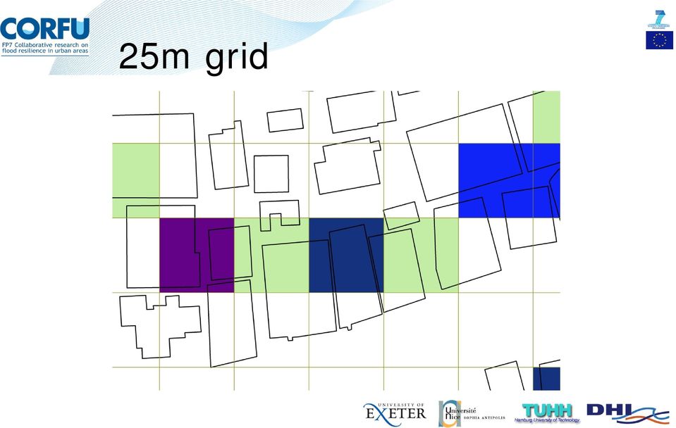
9 Direct tangible flood damage assessment (ex-ante) Flood damage related to key parameters Impact parameters characteristics of the floodwaters e.g. flooded depth, flow velocity, flooded duration Resistance parameters characteristics of the affected asset e.g. building use, building materials Expressed through flood damage functions Most typically a function of depth Different asset types will have different damage functions

10

11 Direct tangible flood damage assessment (ex-ante) Building, infrastructure or land-use information Flood characteristics Damage functions Damage ($)

12 Tool requirements Work on a common platform Work with spatial data Flexible with different data types (e.g. raster or polygon) with different resolutions User friendly
 with different")
13 and solutions Work on a common platform Work with spatial data Flexible with different data types (e.g. raster or polygon) with different resolutions User friendly Developed to work in ArcGIS Interacts with data via Python Scripts, using in-built geoprocessing functions and executables This ensures algorithms are transferable Single step functionality

14

15 Algorithm for raster flood data Convert vector building data to raster grid Associate each building cell with a damage function Relate the flood depth for each cell to damage Sum over each uniquely identified building Sum over entire model domain

16 Technical challenges Asset data in polygon form Flood data (often) in raster form Polygon data must be converted to a raster format, while retaining the important information Spatial resolution issues Computational resources

17 25m grid
18 5m grid

19 1m grid

20 Presentation outline CORFU project and its objectives Development of the flood damage assessment tool Application of the tool Dhaka City Conclusions and future work

21 Dhaka City, Bangladesh Capital city of Bangladesh Rapidly growing mega-city Witnessed major flooding in 1998 and 2004 Eastern side of city most prone to flooding
22 Dhaka City, Bangladesh Capital city of Bangladesh Rapidly growing mega-city Witnessed major flooding in 1998 and 2004 Eastern side of city most prone to flooding
23 Flood map
24 Building / asset data
25 Depth-damage functions
26 Results Building types Damage per unit area
27 Results Building types Damage per building
28 Presentation outline CORFU project and its objectives Development of the flood damage assessment tool Application of the tool Dhaka City Conclusions and future work
29 Conclusions and future work User-friendly, flexible tool The algorithms are transferrable to other GIS software packages The tool has been extended to incorporate calculations for multiple events to allow estimation of Expected Annual Damage It is being applied in the project case study cities to aid the evaluation of flood risk and the effectiveness of resilience measures The tool will be extended to include other types of flood impacts e.g. health impact assessment
30 Thank you Research on the CORFU (Collaborative research on flood resilience in urban areas) project was funded by the European Commission through Framework Programme 7, Grant Number Michael Hammond Centre for Water Systems, University of Exeter, UK
Flood damage assessment for urban growth scenarios. A. S. Chen, M. J. Hammond, S. Djordjević, D. Butler
 Flood damage assessment for urban growth scenarios A. S. Chen, M. J. Hammond, S. Djordjević, D. Butler Outline Introduction Methodology Assessment tool Conclusions Introduction Drivers and pressures Flood
The development of a flood damage assessment tool for urban areas
 The development of a flood damage assessment tool for urban areas Michael J. Hammond 1, Albert S. Chen 2, Slobodan Djordjević 3, David Butler 4, David M. Khan 5, S. M. M. Rahman 6, A.K. E. Haque 7, O.
Flood damage assessment and estimation of flood resilience indexes
 Flood damage assessment and estimation of flood resilience indexes Barcelona case study Marc Velasco CETaqua Workshop CORFU Barcelona Flood resilience in urban areas the CORFU project Cornellà de Llobregat,
Flood Damage Assessment in Taipei City, Taiwan
 Flood Damage Assessment in Taipei City, Taiwan Ming-Hsi Hsu 1, Meng-Yuan Tsai, Yi-Chieh Lin 3, Albert S. Chen 4, Michael J. Hammond 5, Slobodan Djordjević 6 & David Butler 7 1 National Taiwan University,
Flood risk assessment through a detailed 1D/2D coupled model
 CORFU Project Barcelona Case Study Final Workshop 19 th of May 2014 Flood risk assessment through a detailed 1D/2D coupled model Beniamino Russo Aqualogy Urban Drainage Direction Introduction and general
Analysing Big Data in ArcGIS
 OIL & GAS Analysing Big Data in ArcGIS AIS based risk modelling Esri European Petroleum GIS Conference 2014 Karl John Pedersen 7th November 2014 1 DNV GL 2014 7th November 2014 SAFER, SMARTER, GREENER
DATA RECOVERY SOLUTIONS EXPERT DATA RECOVERY SOLUTIONS FOR ALL DATA LOSS SCENARIOS.

INTRODUCTION TO ARCGIS SOFTWARE
 INTRODUCTION TO ARCGIS SOFTWARE I. History of Software Development a. Developer ESRI - Environmental Systems Research Institute, Inc., in 1969 as a privately held consulting firm that specialized in landuse
Flood Modelling for Cities using Cloud Computing FINAL REPORT. Vassilis Glenis, Vedrana Kutija, Stephen McGough, Simon Woodman, Chris Kilsby
 Summary Flood Modelling for Cities using Cloud Computing FINAL REPORT Vassilis Glenis, Vedrana Kutija, Stephen McGough, Simon Woodman, Chris Kilsby Assessment of pluvial flood risk is particularly difficult
Flood Damage Model Case Study Results
 Work Package: Document Name: WP3 Impact Assessment Flood Damage Model Case Study Results Date: 11 August 2014 Report Number: D3.4 Revision Number: 2 Deliverable Number: D3.4 Due date for deliverable: 31
Flood Impact Assessment Literature Review
 Work Package: Document Name: WP3 Impact Assessment Flood Impact Assessment Literature Review Date: 15 August 2014 Report Number: D3.1 Revision Number: 2 Deliverable Number: D3.1 Due date for deliverable:
Managing sewer flood risk
 Managing sewer flood risk J. Ryu 1 *, D. Butler 2 1 Environmental and Water Resource Engineering, Department of Civil and Environmental Engineering, Imperial College, London, SW7 2AZ, UK 2 Centre for Water
RailML use in the project
 French institute of science and technology for transport, spatial planning, development and networks RailML use in the project Grégory Marlière Optimal Networks for Train Integration Management across
How To Calculate Flood Damage Potential In European Landscape
 Background/Introduction RISK ANALYSIS MODULE 3, CASE STUDY 2 Flood Damage Potential at European Scale By Dr. Peter Burek There is good reason to be concerned about the growth of flood losses in Europe.
Flood Damage Estimation based on Flood Simulation Scenarios and a GIS Platform
 European Water 30: 3-11, 2010. 2010 E.W. Publications Flood Damage Estimation based on Flood Simulation Scenarios and a GIS Platform A. Pistrika National Technical University of Athens Centre for the Assessment
Vulnerability analysis
 Chapter 5 Vulnerability analysis Vulnerability is the degree of loss to a given element or set of elements at risk resulting from the occurrence of a natural phenomenon of a given magnitude. It is expressed
Flood Impacts on Road Transportation Using Microscopic Traffic Modelling Technique Contributions
 Flood Impacts on Road Transportation Using Microscopic Traffic Modelling Technique Contributions Katya Pyatkova 1, Albert S. Chen 1, Slobodan Djordjević 1, David Butler 1, Zoran Vojinović 2, Yared A. Abebe
ANALYSIS 3 - RASTER What kinds of analysis can we do with GIS?
 ANALYSIS 3 - RASTER What kinds of analysis can we do with GIS? 1. Measurements 2. Layer statistics 3. Queries 4. Buffering (vector); Proximity (raster) 5. Filtering (raster) 6. Map overlay (layer on layer
Impact of water harvesting dam on the Wadi s morphology using digital elevation model Study case: Wadi Al-kanger, Sudan
 Impact of water harvesting dam on the Wadi s morphology using digital elevation model Study case: Wadi Al-kanger, Sudan H. S. M. Hilmi 1, M.Y. Mohamed 2, E. S. Ganawa 3 1 Faculty of agriculture, Alzaiem
NATIONAL CLIMATE CHANGE & WILDLIFE SCIENCE CENTER & CLIMATE SCIENCE CENTERS DATA MANAGEMENT PLAN GUIDANCE
 NATIONAL CLIMATE CHANGE & WILDLIFE SCIENCE CENTER & CLIMATE SCIENCE CENTERS DATA MANAGEMENT PLAN GUIDANCE Prepared by: NCCWSC/CSC Data Management Working Group US Geological Survey February 26, 2013 Version
Understanding Raster Data
 Introduction The following document is intended to provide a basic understanding of raster data. Raster data layers (commonly referred to as grids) are the essential data layers used in all tools developed
SESSION 8: GEOGRAPHIC INFORMATION SYSTEMS AND MAP PROJECTIONS
 SESSION 8: GEOGRAPHIC INFORMATION SYSTEMS AND MAP PROJECTIONS KEY CONCEPTS: In this session we will look at: Geographic information systems and Map projections. Content that needs to be covered for examination
DISASTER DISASTER MANAGEMENT CRISIS INFORMATICS GIS IN DIFFEERENT STAGES OF DISASTER MANAGEMENT
 APPLICATION OF GIS AND REMOTE SENSING IN DISASTER PRONE AREAS: A CASE STUDY IN COASTAL KERALA DISASTER Disaster is an unpleasant event than occurs with little or no warning which results in economic disruption,
A Method Using ArcMap to Create a Hydrologically conditioned Digital Elevation Model
 A Method Using ArcMap to Create a Hydrologically conditioned Digital Elevation Model High resolution topography derived from LiDAR data is becoming more readily available. This new data source of topography
Lesson 15 - Fill Cells Plugin
 15.1 Lesson 15 - Fill Cells Plugin This lesson presents the functionalities of the Fill Cells plugin. Fill Cells plugin allows the calculation of attribute values of tables associated with cell type layers.
ArcGIS ArcMap: Printing, Exporting, and ArcPress
 Esri International User Conference San Diego, California Technical Workshops July 25th, 2012 ArcGIS ArcMap: Printing, Exporting, and ArcPress Michael Grossman Jeremy Wright Workshop Overview Output in
Toma Danila Dragos. National Institute for Earth Physics Romania
 Toma Danila Dragos National Institute for Earth Physics Romania Before: evaluate the hazard and risk, be prepared for worst case scenario Natural or antropic disaster After: quickly evaluate the situation
06 - NATIONAL PLUVIAL FLOOD MAPPING FOR ALL IRELAND THE MODELLING APPROACH
 06 - NATIONAL PLUVIAL FLOOD MAPPING FOR ALL IRELAND THE MODELLING APPROACH Richard Kellagher 1, Mike Panzeri 1, Julien L Homme 1, Yannick Cesses 1, Ben Gouldby 1 John Martin 2, Oliver Nicholson 2, Mark
How To Write An Nccwsc/Csc Data Management Plan
 Guidance and Requirements for NCCWSC/CSC Plans (Required for NCCWSC and CSC Proposals and Funded Projects) Prepared by the CSC/NCCWSC Working Group Emily Fort, Data and IT Manager for the National Climate
Where is Risk MAP Now? Update on the Flood Risk Assessment Dataset. Shane Parson RAMPP
 Where is Risk MAP Now? Update on the Flood Risk Assessment Dataset Shane Parson RAMPP Agenda Overview Average Annualized Loss (AAL Study) Risk MAP Flood Risk Assessment Dataset Process AAL Data Refined
NetCDF and HDF Data in ArcGIS
 2013 Esri International User Conference July 8 12, 2013 San Diego, California Technical Workshop NetCDF and HDF Data in ArcGIS Nawajish Noman Kevin Butler Esri UC2013. Technical Workshop. Outline NetCDF
INDIVIDUAL COURSE DETAILS
 INDIVIDUAL COURSE DETAILS A. Name of Institution NATIONAL INSTITUTE OF TECHNICAL TEACHERS TRAINING AND RESEARCH TARAMANI CHENNAI 600 113 [An Autonomous Institute under Ministry of Human Resource Development,
Building & Developing the Environmental
 Building & Developing the Environmental Web Explorer for Riyadh City Authors: Engineer Yousef Bin Othman Al-Fariheedi Manager of Environmental Data Unit Environmental Management and Protection Department
Contents. Specific and total risk. Definition of risk. How to express risk? Multi-hazard Risk Assessment. Risk types
 Contents Multi-hazard Risk Assessment Cees van Westen United Nations University ITC School for Disaster Geo- Information Management International Institute for Geo-Information Science and Earth Observation
A GRID-BASED APPROACH FOR SPATIAL VULNERABILITY ASSESSMENT TO FLOODS: A CASE STUDY ON THE COASTAL AREA OF BANGLADESH
 A GRID-BASED APPROACH FOR SPATIAL VULNERABILITY ASSESSMENT TO FLOODS: A CASE STUDY ON THE COASTAL AREA OF BANGLADESH D. C. Roy a, *, T. Blaschke a a Centre for Geoinformatics (Z_GIS), University of Salzburg,
San Francisco Bay Margin Conservation Decision Support System (DSS)
") San Francisco Bay Margin Conservation Decision Support System (DSS) Presented by Brian Fulfrost1, MS David Thomson2, MS 1 Brian Fulfrost and Associates 2 San Francisco Bay Bird Observatory Transitional
San Francisco Bay Margin Conservation Decision Support System (DSS) Presented by Brian Fulfrost1, MS David Thomson2, MS 1 Brian Fulfrost and Associates 2 San Francisco Bay Bird Observatory Transitional
Assessment of Groundwater Vulnerability to Landfill Leachate Induced Arsenic Contamination in Maine, US - Intro GIS Term Project Final Report
 Assessment of Groundwater Vulnerability to Landfill Leachate Induced Arsenic Contamination in Maine, US - Intro GIS Term Project Final Report Introduction Li Wang Dept. of Civil & Environmental Engineering
GIS Based Risk Analysis Simplifying the Risk Assessment Process
 GIS Based Risk Analysis Simplifying the Risk Assessment Process David Adler Principal Engineer System Integrity NiSource Gas Transmission and Storage John Beets Principal GIS Technologist Willbros Engineering
Disaster Risk Assessment:
 Disaster Risk Assessment: Disaster Risk Mapping Dr. Jianping Yan Disaster Risk Assessment Specialist Session Outline Essentials on Risk Mapping Map scale, grid size, aggregation unit Requirements for Risk
Automating the evaluation of flood damages
 (GSP) Management of Public Utilities / (IMFS) Mechanical Institute of Fluids and Solids Ecole Nationale de l Eau et de l Environnement de Strasbourg / Cemagref / CNRS / UdS Automating the evaluation of
A GIS helps you answer questions and solve problems by looking at your data in a way that is quickly understood and easily shared.
 A Geographic Information System (GIS) integrates hardware, software, and data for capturing, managing, analyzing, and displaying all forms of geographically referenced information. GIS allows us to view,
BEST PRACTICE GUIDELINES FOR FLOOD RISK ASSESSMENT IN THE LOWER MEKONG RIVER BASIN
 Paper 3-4-3 BEST PRACTICE GUIDELINES FOR FLOOD RISK ASSESSMENT IN THE LOWER MEKONG RIVER BASIN GERT SLUIMER 1, HENK OGINK 2, FERDINAND DIERMANSE 2, FRANK KEUKELAAR 1, BAS JONKMAN 1, TRAN KIM THANH 3 AND
Modelling of Urban Flooding in Dhaka City
 Modelling of Urban Flooding in Dhaka City Chusit Apirumanekul*, Ole Mark* *Water Engineering & Management, Asian Inst. of Technology, PO Box 4, Klong Luang, Pathumthani 12120, Thailand Abstract Flooding
Section 6 Benefit-Cost Analysis
 6.1 Introduction For the preferred storage alternatives, a benefit-cost analysis (BCA) was conducted to evaluate the economic feasibility of implementation. The economic evaluation was conducted using
Flooding Fast Facts. flooding), seismic events (tsunami) or large landslides (sometime also called tsunami).
, seismic events (tsunami) or large landslides (sometime also called tsunami).") Flooding Fast Facts What is a flood? Flooding is the unusual presence of water on land to a depth which affects normal activities. Flooding can arise from: Overflowing rivers (river flooding), Heavy rainfall
Flooding Fast Facts What is a flood? Flooding is the unusual presence of water on land to a depth which affects normal activities. Flooding can arise from: Overflowing rivers (river flooding), Heavy rainfall
Darja Tretjakova MANAGING FLOOD RISK IN INTERNATIONAL HARBOURS
 Darja Tretjakova MANAGING FLOOD RISK IN INTERNATIONAL HARBOURS Outline Origins and reasons Methodology Results Conclusions 2 Why this research? Increasing flood risk: CC, socio-economic development Port
How To Understand And Understand The Flood Risk Of Hoang Long River In Phuon Vietnam
 FLOOD HAZARD AND RISK ASSESSMENT OF HOANG LONG RIVER BASIN, VIETNAM VU Thanh Tu 1, Tawatchai TINGSANCHALI 2 1 Water Resources University, Assistant Professor, 175 Tay Son Street, Dong Da District, Hanoi,
Spatial data models (types) Not taught yet
 Not taught yet") Spatial data models (types) Not taught yet A new data model in ArcGIS Geodatabase data model Use a relational database that stores geographic data A type of database in which the data is organized across
Spatial data models (types) Not taught yet A new data model in ArcGIS Geodatabase data model Use a relational database that stores geographic data A type of database in which the data is organized across
Natural Hazard Risk Assessment in the Australasian Region: Informing Disaster Risk Reduction and Building Community Resilience.
 Natural Hazard Risk Assessment in the Australasian Region: Informing Disaster Risk Reduction and Building Community Resilience Jane Sexton Australia and Disaster Risk Reduction Australian Context Understanding
VULNERABILITY FLOOD STANDARDS. VF-1 Derivation of Residential Structure and Contents Flood Vulnerability Functions
 VULNERABILITY FLOOD STANDARDS VF-1 Derivation of Residential Structure and Contents Flood Vulnerability Functions A. Specification of the residential structure and contents flood vulnerability functions
CORRELATIONS BETWEEN RAINFALL DATA AND INSURANCE DAMAGE DATA ON PLUVIAL FLOODING IN THE NETHERLANDS
 10 th International Conference on Hydroinformatics HIC 2012, Hamburg, GERMANY CORRELATIONS BETWEEN RAINFALL DATA AND INSURANCE DAMAGE DATA ON PLUVIAL FLOODING IN THE NETHERLANDS SPEKKERS, M.H. (1), TEN
Integrated Restoration Prioritization
 Integrated Restoration Prioritization Habitat Restoration and Environmental Monitoring Projects Section Restoration Services Division Definition Restoration Prioritization is a process of combining various
ArcGIS Data Models Practical Templates for Implementing GIS Projects
 ArcGIS Data Models Practical Templates for Implementing GIS Projects GIS Database Design According to C.J. Date (1995), database design deals with the logical representation of data in a database. The
Development of an Integrated Data Product for Hawaii Climate
 Development of an Integrated Data Product for Hawaii Climate Jan Hafner, Shang-Ping Xie (PI)(IPRC/SOEST U. of Hawaii) Yi-Leng Chen (Co-I) (Meteorology Dept. Univ. of Hawaii) contribution Georgette Holmes
What do I do first in ArcView 8.x? When the program starts Select from the Dialog box: A new empty map
 www.library.carleton.ca/find/gis Introduction Introduction to Georeferenced Images using ArcGIS Georeferenced images such as aerial photographs or satellite images can be used in many ways in both GIS
Big Data and Analytics: Getting Started with ArcGIS. Mike Park Erik Hoel
 Big Data and Analytics: Getting Started with ArcGIS Mike Park Erik Hoel Agenda Overview of big data Distributed computation User experience Data management Big data What is it? Big Data is a loosely defined
Creating Geospatial Metadata. Kim Durante Geo4Lib Camp
 Creating Geospatial Metadata Kim Durante Geo4Lib Camp Overview Metadata requirements for geospatial data Workflows for creating layer-level ISO metadata Auto-generating metadata using templates, XSL, Python,
Adapting to climate change, Reducing poverty a German Financial Cooperation project in Khulna
 Adapting to climate change, Reducing poverty a German Financial Cooperation project in Khulna The KfW-ADB City Region Development Project Peter Rooney Christian Schönhofen Monika Wiebusch Bonn, June 3,
An approach to the model-based spatial assessment of damages caused by urban floods Z. Vojinovic 1 *, J.C.W. Ediriweera 2 and A.K.
 An approach to the model-based spatial assessment of damages caused by urban floods Z. Vojinovic 1 *, J.C.W. Ediriweera 2 and A.K. Fikri 3 1/2/3 Department of Hydroinformatics and Knowledge Management,
GIS in Wastewater Collection System Master Planning
 Page 1 of 6 GIS in Wastewater Collection System Master Planning Brad Roeth, EIT Stanley Consultants, Inc. This paper presents the use of GIS in a wastewater collection system master plan. The master plan
Depth-Damage Curve for Flood Damage Assessments Industrial and Commercial Sectors
 Depth-Damage Curve for Flood Damage Assessments Industrial and Commercial Sectors Ling-Fang Chang 1 Jui-Lin Kang 2 Ming-Daw Su 2 Research Center for Humanities Department of Bioenvironmental Department
Reading Questions. Lo and Yeung, 2007: 2 19. Schuurman, 2004: Chapter 1. 1. What distinguishes data from information? How are data represented?
 Reading Questions Week two Lo and Yeung, 2007: 2 19. Schuurman, 2004: Chapter 1. 1. What distinguishes data from information? How are data represented? 2. What sort of problems are GIS designed to solve?
Introduction to GIS (Basics, Data, Analysis) & Case Studies. 13 th May 2004. Content. What is GIS?
 & Case Studies. 13 th May 2004. Content. What is GIS?") Introduction to GIS (Basics, Data, Analysis) & Case Studies 13 th May 2004 Content Introduction to GIS Data concepts Data input Analysis Applications selected examples What is GIS? Geographic Information
Introduction to GIS (Basics, Data, Analysis) & Case Studies 13 th May 2004 Content Introduction to GIS Data concepts Data input Analysis Applications selected examples What is GIS? Geographic Information
Student Seminar Building climate resilient cities: Exploring theories, practices and prospects 16-17 Feb 2015
 Student Seminar Building climate resilient cities: Exploring theories, practices and prospects 16-17 Feb 2015 Database Management System for coastal cities Rozita Singh, Research Associate, Sustainable
URBAN ROAD ACCIDENTS IN DHAKA, BANGLADESH
 URBAN ROAD ACCIDENTS IN DHAKA, BANGLADESH Dr. Ishtiaque Ahmed Associate Professor, Faculty of Civil Engineering University Technology Malaysia (UTM), Johor Bahru 81310, Malaysia E-mail: [email protected]
A quick overview of geographic information systems (GIS) Uwe Deichmann, DECRG <[email protected]>
 Uwe Deichmann, DECRG <udeichmann@worldbank.org>") A quick overview of geographic information systems (GIS) Uwe Deichmann, DECRG Why is GIS important? A very large share of all types of information has a spatial component ( 80
A quick overview of geographic information systems (GIS) Uwe Deichmann, DECRG Why is GIS important? A very large share of all types of information has a spatial component ( 80
Plan Plus Volume 1 No 1 2002 (117-123)
") Plan Plus Volume 1 No 1 2002 (117-123) APPLICATION OF GIS (GEOGRAPHIC INFORMATION SYSTEM) FOR LANDSLIDE HAZARD ZONATION AND MAPPING DISASTER PRONE AREA: A STUDY OF KULEKHANI WATERSHED, NEPAL Purna Chandra
Plan Plus Volume 1 No 1 2002 (117-123) APPLICATION OF GIS (GEOGRAPHIC INFORMATION SYSTEM) FOR LANDSLIDE HAZARD ZONATION AND MAPPING DISASTER PRONE AREA: A STUDY OF KULEKHANI WATERSHED, NEPAL Purna Chandra
Geoprocessing Tools for Surface and Basement Flooding Analysis in SWMM
 3 Geoprocessing Tools for Surface and Basement Flooding Analysis in SWMM Eric White, James Knighton, Gary Martens, Matthew Plourde and Rajesh Rajan A geoprocessing routine was used for the development
Training Program on Urban Climate Change Resilience 20-22 April, 2015 Database Management System for coastal cities
 Training Program on Urban Climate Change Resilience 20-22 April, 2015 Database Management System for coastal cities Rozita Singh, Research Associate, Sustainable Habitat Division, TERI Why Data? Infrastructure
Drought Risk Assessment:
 Drought Risk Assessment: Mapping the Vulnerability of Agricultural Systems Dr. Jianping Yan Disaster Risk Assessment Specialist Session Outline Understanding the Concept of Vulnerability Mapping the Agricultural
Decision support for urban drainage using radar data of HydroNET-SCOUT
 Weather Radar and Hydrology (Proceedings of a symposium held in Exeter, UK, April 2011) (IAHS Publ. 351, 2011). 1 Decision support for urban drainage using radar data of HydroNET-SCOUT ARNOLD LOBBRECHT
Real-time hazard impact modelling for surface water flooding: some UK developments
 Real-time hazard impact modelling for surface water flooding: some UK developments Steven Cole 1, Bob Moore 1, Timothy Aldridge 2, Andy Lane 3,4 and Stefan Laeger 4 International Conference on Flood Resilience,
Tutorial 8 Raster Data Analysis
 Objectives Tutorial 8 Raster Data Analysis This tutorial is designed to introduce you to a basic set of raster-based analyses including: 1. Displaying Digital Elevation Model (DEM) 2. Slope calculations
URBAN FLOOD RISK MANAGEMENT X X X X X X X X X X X X X. A Tool for Integrated Flood Management X X X X X X
 World Meteorological Organization URBAN FLOOD RISK MANAGEMENT X X X X X X X X X X X X X A Tool for Integrated Flood Management X X X X X X ASSOCIATED PROGRAMME ON FLOOD MANAGEMENT March 2008 The Associated
ArcGIS Server and Geodatabase Administration for 10.2
 TRAINING GUIDE ArcGIS Server and Geodatabase Administration for 10.2 Part 2 ArcGIS for Server v10.2 and Geodatabase Administration - Part 2 This session touches on key elements of maintaining enterprise
Performance Testing in Virtualized Environments. Emily Apsey Product Engineer
 Performance Testing in Virtualized Environments Emily Apsey Product Engineer Introduction Product Engineer on the Performance Engineering Team Overview of team - Specialty in Virtualization - Citrix, VMWare,
UFZ Discussion Papers
 UFZ Discussion Papers Department of Economics 13/2005 Flood damage, vulnerability and risk perception challenges for flood damage research Frank Messner, Volker Meyer April 2005 Dr. Frank Messner ([email protected])
FOR375 EXAM #2 STUDY SESSION SPRING 2016. Lecture 14 Exam #2 Study Session
 FOR375 EXAM #2 STUDY SESSION SPRING 2016 Lecture 14 Exam #2 Study Session INTRODUCTION TO REMOTE SENSING TYPES OF REMOTE SENSING Ground based platforms Airborne based platforms Space based platforms TYPES
An Introduction to Open Source Geospatial Tools
 An Introduction to Open Source Geospatial Tools by Tyler Mitchell, author of Web Mapping Illustrated GRSS would like to thank Mr. Mitchell for this tutorial. Geospatial technologies come in many forms,
Modelling Flood Inundation of Urban Areas in the UK Using 2D / 1D Hydraulic Models
 Modelling Flood Inundation of Urban Areas in the UK Using 2D / 1D Hydraulic Models W.J. Syme B.E., M.Eng.Sc. Associate, WBM Pty. Ltd., Australia M.G. Pinnell Bsc Msc MCIWEM Principal Hydrologist, Symonds
We make Smart Cities a reality. Schneider Electric Smart Cities
 We make Smart Cities a reality 1 5 steps to smart Set the vision: an efficient + liveable + sustainable city. Combine hardware + software solutions to improve the efficiency of urban operating systems
12-3-2014. After MGI. MGI celebration series. Hilbert Davelaar Project Manager GIS&ICT. Wageningen, 12 March 2013
 After MGI MGI celebration series Hilbert Davelaar Project Manager GIS&ICT Wageningen, 12 March 2013 1 Introduction 2 Hilbert Davelaar MSc 2000 2003 WUR BLP 2003 2005 WUR MGI Thesis: Participatory planning
Dr. Shih-Lung Shaw s Research on Space-Time GIS, Human Dynamics and Big Data
 Dr. Shih-Lung Shaw s Research on Space-Time GIS, Human Dynamics and Big Data for Geography Department s Faculty Research Highlight October 12, 2014 Shih-Lung Shaw, Ph.D. Alvin and Sally Beaman Professor