Creating Geospatial Metadata. Kim Durante Geo4Lib Camp
|
|
|
- Edgar Barker
- 7 years ago
- Views:
Transcription
1 Creating Geospatial Metadata Kim Durante Geo4Lib Camp

2 Overview Metadata requirements for geospatial data Workflows for creating layer-level ISO metadata Auto-generating metadata using templates, XSL, Python, and data extraction Transforming and exporting metadata

3 Collection-level Metadata Workflow Identify data collection Layers Create metadata Assign rights policy register Repository

4 Check Data Properties Filenames Spatial Reference Objects Attributes

5 Layer-level Metadata Workflow Check data properties layer Items with no existing metadata Template XSLT Items with existing metadata localized Assign collection and rights policy register auto-generate deposit Submit for accessioning

6
7

8 Required and Recommended Elements Title Originator Distributor Publisher Date Point of Contact Distribution Format Scale Resolution Abstract Identifier Distribution Protocol Lineage Language Theme keyword Distribution Name Status Metadata Contact Metadata DateStamp ISO Topic Category Place keyword Geographic Extent Temporal Extent Aggregate Dataset Title Aggregate Dataset Identifier Update Frequency Access Constraints Use Constraints Metadata Identifier Parent Metadata Identifier Credit Hierarchy Level

9 XML Template Thesauri Citations Metadata Contact Distributor Contact lcsh, lcnaf, geonames Stanford Stanford Citation Thesaurus Name: lcsh Identifier: Date: T00:00:00 Contact Organisation Name: Stanford City: Stanford State: California Zip Code:

10 XML Template Title Abstract Purpose Theme keyword Place keyword Originator Publisher Point of Contact TITLE ABSTRACT PURPOSE THEME PLACE ORIGINATOR PUBLISHER POINT OF CONTACT

11 XML Template Identifier (Online linkage) Online Distribution URL Online distribution filename Parent Metadata Identifier Aggregate Dataset Title Aggregate Dataset Identifier Credit Feature Catalog Title Feature Catalog Identifier Metadata file identifier* URL URL FILENAME PARENTID COLLECTIONTITLE COLLECTIONID CREDIT FCTITLE UUID METADATAID*

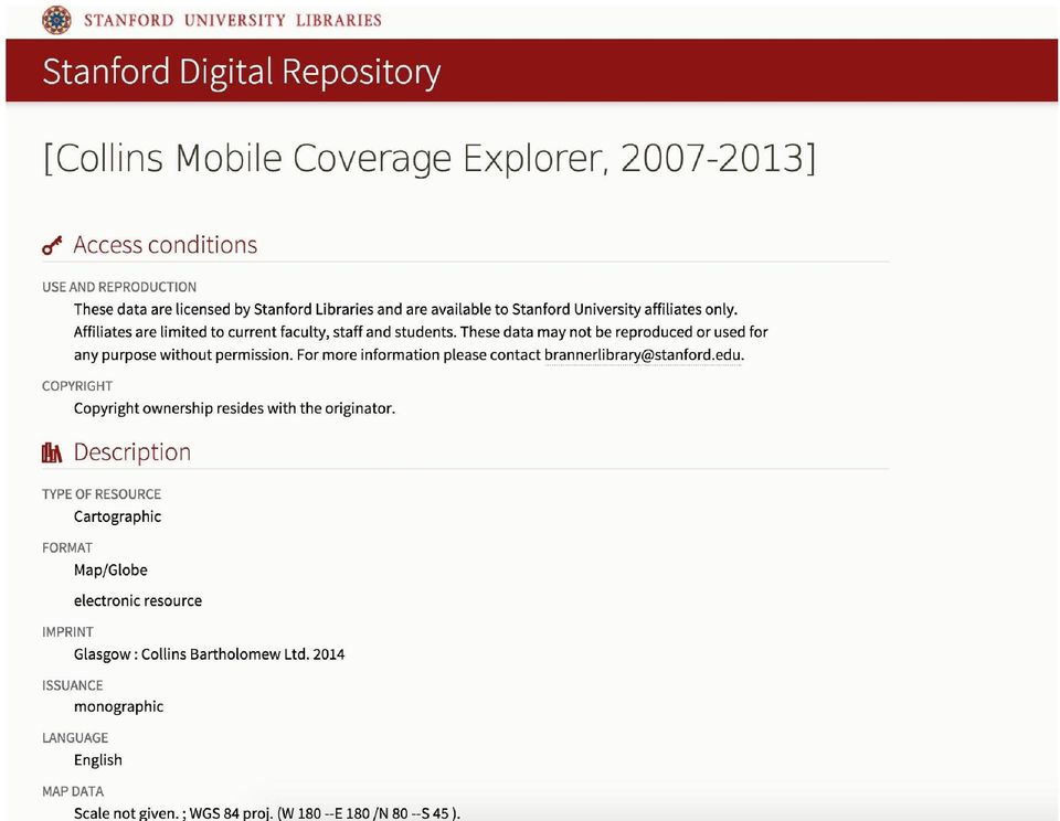
12 Collection Template Originator Publisher Point of Contact Collins Bartholomew Ltd. Collins Bartholomew Ltd. Collins Bartholomew Ltd. Publication Date ISO Topic Category Place keyword Theme keyword Parent Metadata Identifier Utilities and Communication Earth Global system for mobile communications

13 Collection Template Title Abstract Update Frequency Status Global XG Mobile Communications Network Coverage, YYYY This polygon shapefile is a representation of the coverage area for XG mobile communications networks around the world in YYYY. The data is created from submissions made directly to Collins Bartholomew or the GSMA from mobile operators, which provide roaming detail for inclusion in the online mapping application known as Collins Mobile Coverage Web. Polygons representing the network coverage have been split into country areas using the country polygons from the Collins World Explorer vector product. Polygons are supplied as multipart, and include any country ISO or FIPS codes where known. The data is supplied with a nominal resolution of approximately 1km on the ground. Annually Completed

14 Collection Template Aggregate Dataset Title Collins Mobile Coverage Explorer, Aggregate Dataset Identifier Supplemental information Access Constraints (Legal) Use Constraints (Legal) Temporal Extent Description Purpose Operators are asked to submit strong (>= -92dBm) and variable (>= -100dBm and <92dBm) signal strengths as part of their submissions. The data here includes both types but does not make a distinction between the two. Restricted Restricted ground condition This map can be used to locate and analyze mobile communications coverage on a global scale.

15 Import Collection Template Geoprocessing Python import arcpy from arcpy import env import os env.workspace: C:/Desktop/Geo4Lib/Mobile for dirname, subdirs, filenames in os.walk(env.workspace): for f in filenames: if f.endswith('shp') or f.endswith(.tif ): f = os.path.join(dirname, f) arcpy.importmetadata_conversion('mobile.xml',f)
: for f in filenames: if f.endswith('shp') or f.endswith(.tif ): f = os.")
16 Localized Editing Title Global 2G Mobile Communications Network Coverage, 2007 Abstract This polygon shapefile is a representation of the coverage area for 2G mobile communications networks around the world in The data is created from submissions made directly to Collins Bartholomew or the GSMA from mobile operators, which provide roaming detail for inclusion in the online mapping application known as Collins Mobile Coverage Web. Polygons representing the network coverage have been split into country areas using the country polygons from the Collins World Explorer vector product. Polygons are supplied as multipart, and include any country ISO or FIPS codes where known. The data is supplied with a nominal resolution of approximately 1km on the ground. Temporal extent begin: end:

17 Localized Editing

18 Attribute Definitions ATTRIBUTE LABEL CNTRY_CODE COUNTRY ATTRIBUTE DEFINITION a unique numerical identifier for each country country name, in English CNTRY_ISO a unique numerical code based on the ISO standard CNTRY_ISO2 a unique alpha-2 code based on the ISO standard CNTRY_ISO3 a unique alpha-3 code based on the ISO standard CNTRY_FIPS a unique alpha-2 code based on the FIPS 10-4 standard

19 Registering Layers Source_ID Title Global_GSM_2007Q1.shp Global 2G Mobile Communications Network Coverage, 2007 Global_GSM_2008Q1.shp Global 2G Mobile Communications Network Coverage, 2008 Global_GSM_2009Q1.shp Global 2G Mobile Communications Network Coverage, 2009 Global_GSM_ shp Global 2G Mobile Communications Network Coverage, 2011 Global_GSM_ shp Global 2G Mobile Communications Network Coverage, 2012 Global_GSM_ shp Global 2G Mobile Communications Network Coverage, 2013 Global_GSM_2007Q1.shp Global 2G Mobile Communications Network Coverage, 2007 Global_GSM_2008Q1.shp Global 2G Mobile Communications Network Coverage, 2008

20 Registering Layers Source_ID Title DRUID Global_GSM_2007Q1.shp Global 2G Mobile Communications Network Coverage, 2007 nm879wg1606 Global_GSM_2008Q1.shp Global 2G Mobile Communications Network Coverage, 2008 tv718rb3367 Global_GSM_2009Q1.shp Global 2G Mobile Communications Network Coverage, 2009 rc929pg4438 Global_GSM_ shp Global 2G Mobile Communications Network Coverage, 2011 cm290sm0643 Global_GSM_ shp Global 2G Mobile Communications Network Coverage, 2012 fq595rd0954

21 Identifiers Source_ID Title DRUID UUID Global_GSM_2007Q1.shp Global 2G Mobile Communications Network Coverage, 2007 nm879wg1606 f3a3374e fd-98c7-c2fbfb Global_GSM_2008Q1.shp Global 2G Mobile Communications Network Coverage, 2008 tv718rb3367 ab18d0cc-0ff8-472c-831c bd808e Global_GSM_2009Q1.shp Global 2G Mobile Communications Network Coverage, 2009 rc929pg c04bc9-f289-47b0-a3d2-3f2c67aabb67 Global_GSM_ shp Global 2G Mobile Communications Network Coverage, 2011 cm290sm0643 c3e68635-b7cb-4aae-8b de92bf5 Global_GSM_ shp Global 2G Mobile Communications Network Coverage, 2012 fq595rd a298ca-6bd3-497e-8790-b3f6995f9c65
22 Auto-generating Metadata Dataset Identifier Dataset URI Distribution URL Distribution Filename Global_GSM_2007Q1.shp Metadata FIle Identifier edu.stanford.purl:nm879wg1606 Feature Catalog Title (ISO 19110) Feature Catalog Identifier (ISO 19110) Feature catalog for Global 2G Mobile Communications Network Coverage, 2007 f3a3374e fd-98c7-c2fbfb524284
23 Attribute Definitions ATTRIBUTE LABEL CNTRY_CODE COUNTRY ATTRIBUTE DEFINITION a unique numerical identifier for each country country name, in English CNTRY_ISO a unique numerical code based on the ISO standard CNTRY_ISO2 a unique alpha-2 code based on the ISO standard CNTRY_ISO3 a unique alpha-3 code based on the ISO standard CNTRY_FIPS a unique alpha-2 code based on the FIPS 10-4 standard
24 Attribute Definitions LABEL DEFINITION
25 Creating ISO Metadata ArcGIS to ISO using XSLT (arc xsl): Feature Catalog Title Feature Catalog Identifier (uuid) Originator Attribute Labels Attribute Definitions
26 Updating Existing Metadata Varies according to collection Preserves existing metadata XSLT adds required and recommended elements Normalizes existing values (themes, places, names, etc.) May require localized editing
27 Update Metadata Geoprocessing Python import arcpy from arcpy import env import os env.workspace: C:/Desktop/Geo4Lib/NationalAtlas for dirname, subdirs, filenames in os.walk(env.workspace): for f in filenames: if f.endswith('shp.xml') or f.endswith(.tif.xml ) of f.endswith( metadata.xml ): f = os.path.join(dirname, f) arcpy.xsltransform_conversion(f,' modify.xsl', f)
28 Updating Existing Metadata - Titles WIND_FARMS.shp Wind Farms, United States, 2015 Average Annual Rainfall, Monterey County, California Average Annual Rainfall, Monterey County, California, 2010 Current Distributions of Selected Amphibians in the United States Current Distributions of Selected Amphibians in the United States, USGS Small-scale Dataset - 1:1,000,000-Scale Urban Areas Shapefile 1:1,000,000-Scale Urban Areas, United States, 2013 North American Bat Ranges - Direct Download North American Bat Ranges,
29 Temporal Extents Ground Condition vs. Publication date Other Considerations Related items Lineage metadata for source materials Custom Projections Use free text to describe projections when no codes exist Rights - Access and Use Conditions Restricted, Public domain, Creative Commons, GNU
30 Geometry Types Point, Line, Polygon Other Considerations Distribution Formats Shapefile, Raster Dataset (GeoTIFF, ArcGRID,.) Collection Development $$$$$
31 Thanks
EEOS 381 - Spatial Databases and GIS Applications
 EEOS 381 - Spatial Databases and GIS Applications Lecture 9 Metadata What is Metadata? Data about data Description of a (GIS) dataset What it represents Who created it? When? How? Format Field definitions
NATIONAL CLIMATE CHANGE & WILDLIFE SCIENCE CENTER & CLIMATE SCIENCE CENTERS DATA MANAGEMENT PLAN GUIDANCE
 NATIONAL CLIMATE CHANGE & WILDLIFE SCIENCE CENTER & CLIMATE SCIENCE CENTERS DATA MANAGEMENT PLAN GUIDANCE Prepared by: NCCWSC/CSC Data Management Working Group US Geological Survey February 26, 2013 Version
The ORIENTGATE data platform
 Seminar on Proposed and Revised set of indicators June 4-5, 2014 - Belgrade (Serbia) The ORIENTGATE data platform WP2, Action 2.4 Alessandra Nuzzo, Sandro Fiore, Giovanni Aloisio Scientific Computing and
Guidelines on Information Deliverables for Research Projects in Grand Canyon National Park
 INTRODUCTION Science is playing an increasing role in guiding National Park Service (NPS) management activities. The NPS is charged with protecting and maintaining data and associated information that
Mississippi Private Schools 2015
 Mississippi Private Schools 2015 Shapefile Tags education, schools, private, K-12 Summary To add to state data clearinghouse the Mississippi private schools point features. Description Point locations
How To Write An Nccwsc/Csc Data Management Plan
 Guidance and Requirements for NCCWSC/CSC Plans (Required for NCCWSC and CSC Proposals and Funded Projects) Prepared by the CSC/NCCWSC Working Group Emily Fort, Data and IT Manager for the National Climate
GIS Databases With focused on ArcSDE
 Linköpings universitet / IDA / Div. for human-centered systems GIS Databases With focused on ArcSDE Imad Abugessaisa g-imaab@ida.liu.se 20071004 1 GIS and SDBMS Geographical data is spatial data whose
ArcGIS Data Models Practical Templates for Implementing GIS Projects
 ArcGIS Data Models Practical Templates for Implementing GIS Projects GIS Database Design According to C.J. Date (1995), database design deals with the logical representation of data in a database. The
Data Mining and Analysis in ArcGIS Online Joseph Kerski Education Manager Esri jkerski@esri.com Twitter @josephkerski 303-449-7779 x 18237
 Data Mining and Analysis in ArcGIS Online Joseph Kerski Education Manager Esri jkerski@esri.com Twitter @josephkerski 303-449-7779 x 18237 Joseph Kerski Webinar 1 Goals for this workshop 1. Understanding
Metadata for Big River Watershed Geologic and Geomorphic Data
 Metadata for Big River Watershed Geologic and Geomorphic Data Metadata are descriptions and information regarding compiled data. This appendix contains the metadata that describes the compiled data used
Guide to Creating and Editing Metadata in ArcGIS for Publishing to the MSDIS GeoPortal
 Guide to Creating and Editing Metadata in ArcGIS for Publishing to the MSDIS GeoPortal 1). Geoportal publishing requirement For the MSDIS GeoPortal to publish your data there is one requirement that each
GIS Data Quality and Evaluation. Tomislav Sapic GIS Technologist Faculty of Natural Resources Management Lakehead University
 GIS Data Quality and Evaluation Tomislav Sapic GIS Technologist Faculty of Natural Resources Management Lakehead University The quality of GIS data gains in importance when considering some of the main
Geodatabase Programming with SQL
 DevSummit DC February 11, 2015 Washington, DC Geodatabase Programming with SQL Craig Gillgrass Assumptions Basic knowledge of SQL and relational databases Basic knowledge of the Geodatabase We ll hold
New York City Neighborhood Tabulation Areas
 Page 1 of 10 New York City Neighborhood Tabulation Areas ESRI Shapefile Tags New York, boundary, neighborhoods, Manhattan, projection areas, Queens, Brooklyn, Richmond, boundaries, neighborhood names,
Virginia Commonwealth University Rice Rivers Center Data Management Plan
 Virginia Commonwealth University Rice Rivers Center Data Management Plan Table of Contents Objectives... 2 VCU Rice Rivers Center Research Protocol... 2 VCU Rice Rivers Center Data Management Plan... 3
SIP Expert GUI Generic Use Cases and Requirements
 Data / Storage SIP Back-End Requirements Service / API Tools GUI / Client Project 603587 SIP Expert GUI Generic Use Cases and Requirements This document described the generalised uses cases and related
Research Data Archival Guidelines
 Research Data Archival Guidelines LEROY MWANZIA RESEARCH METHODS GROUP APRIL 2012 Table of Contents Table of Contents... i 1 World Agroforestry Centre s Mission and Research Data... 1 2 Definitions:...
A Java Tool for Creating ISO/FGDC Geographic Metadata
 F.J. Zarazaga-Soria, J. Lacasta, J. Nogueras-Iso, M. Pilar Torres, P.R. Muro-Medrano17 A Java Tool for Creating ISO/FGDC Geographic Metadata F. Javier Zarazaga-Soria, Javier Lacasta, Javier Nogueras-Iso,
SAHRA Metadata Guidelines
 SAHRA etadata Guidelines What are etadata? etadata are data or information about data which are usually stored in a structured document. etadata describe the origin, nature, and spatial and temporal location
Choosing the right GIS framework for an informed Enterprise Web GIS Solution
 13 ANNUAL INTERNATIONAL CONFERENCE AND EXHIBITION ON GEOSPATIAL INFORMATION TECHNOLOGY AND APPLICATIONS Epicentre; Gurgaon, India; 19-21 January, 2010 Choosing the right GIS framework for an informed Enterprise
HydroDesktop Overview
 HydroDesktop Overview 1. Initial Objectives HydroDesktop (formerly referred to as HIS Desktop) is a new component of the HIS project intended to address the problem of how to obtain, organize and manage
NetCDF and HDF Data in ArcGIS
 2013 Esri International User Conference July 8 12, 2013 San Diego, California Technical Workshop NetCDF and HDF Data in ArcGIS Nawajish Noman Kevin Butler Esri UC2013. Technical Workshop. Outline NetCDF
Cookbook 23 September 2013 GIS Analysis Part 1 - A GIS is NOT a Map!
 Cookbook 23 September 2013 GIS Analysis Part 1 - A GIS is NOT a Map! Overview 1. A GIS is NOT a Map! 2. How does a GIS handle its data? Data Formats! GARP 0344 (Fall 2013) Page 1 Dr. Carsten Braun 1) A
GeoNetwork User Manual
 GeoNetwork User Manual Release 2.10.4-0 GeoNetwork July 06, 2015 Contents 1 Preface 3 1.1 About this Project..................................... 3 1.2 License Information....................................
Stellwagen Bank/Jeffreys Ledge Restricted Area
 Stellwagen Bank/Jeffreys Ledge Restricted Area Identification CITATION CITATION INFORMATION ORIGINATOR NOAA Fisheries Greater Atlantic Regional Fisheries Office PUBLICATION DATE 2015-06-05 TITLE Stellwagen
Sextant. Spatial Data Infrastructure for Marine Environment. C. Satra Le Bris, E. Quimbert, M. Treguer
 Sextant On-Line information system for marine geographical information E. Quimbert, M. Bellouis, F. Lecuy, M. Treguer Centre de Bretagne BP 70, Plouzané 29280 France E-mail: sextant@ifremer.fr Sextant
D 2.2.3 EUOSME: European Open Source Metadata Editor (revised 2010-12-20)
") Project start date: 01 May 2009 Acronym: EuroGEOSS Project title: EuroGEOSS, a European Theme: FP7-ENV-2008-1: Environment (including climate change) Theme title: ENV.2008.4.1.1.1: European Environment
Project start date: 01 May 2009 Acronym: EuroGEOSS Project title: EuroGEOSS, a European Theme: FP7-ENV-2008-1: Environment (including climate change) Theme title: ENV.2008.4.1.1.1: European Environment
Redlands Institute Manual for Creating Metadata in ArcCatalog
 Redlands Institute Manual for Creating Metadata in ArcCatalog 1.0 Introduction... 3 2.0 ArcCatalog Structure... 4 3.0 General Identification... 5 3.1 Contact... 7 3.2 Citation... 9 3.3 Time Period of Content...
LNG Terminals. File Geodatabase Feature Class. Tags natural gas, lng, liquid natural gas, terminals
 LNG Terminals File Geodatabase Feature Class Tags natural gas, lng, liquid natural gas, terminals Summary This layer can be used to identify the location of existing and proposed LNG Terminals. Description
A GIS helps you answer questions and solve problems by looking at your data in a way that is quickly understood and easily shared.
 A Geographic Information System (GIS) integrates hardware, software, and data for capturing, managing, analyzing, and displaying all forms of geographically referenced information. GIS allows us to view,
Archive I. Metadata. 26. May 2015
 Archive I Metadata 26. May 2015 2 Norstore Data Management Plan To successfully execute your research project you want to ensure the following three criteria are met over its entire lifecycle: You are
Downloading SSURGO Soil Data from Internet
 Downloading SSURGO Soil Data from Internet Prepared by Venkatesh Merwade School of Civil Engineering, Purdue University vmerwade@purdue.edu September 2012 Purpose The purpose of this exercise to demonstrate
MAIN_SNP_TOPO.dgm_2m
 Seite 1 von 7 MAIN_SNP_TOPO.dgm_2m SDE Raster Dataset Tags dgm_2m, dgm_gr_snp, dgm1177bis1258, dtm4, lomb_dtm_20, dem2_5_apb, dhm10, dem20_apb, dsm2_voralberg, dsm10_tirol Summary There is no summary for
How To Use The Alabama Data Portal
 113 The Alabama Metadata Portal: http://portal.gsa.state.al.us By Philip T. Patterson Geological Survey of Alabama 420 Hackberry Lane P.O. Box 869999 Tuscaloosa, AL 35468-6999 Telephone: (205) 247-3611
Buurten van gemeente Groningen
 Page 1 of 7 Buurten van gemeente Groningen Shapefile Tags Buurtindeling Groningen Summary buurtindeling van de gemeente Groningen, buurten zijn samengesteld uit subbuurten Description Het bestand buurtindeling.shp
REACCH PNA Data Management Plan
 REACCH PNA Data Management Plan Regional Approaches to Climate Change (REACCH) For Pacific Northwest Agriculture 875 Perimeter Drive MS 2339 Moscow, ID 83844-2339 http://www.reacchpna.org reacch@uidaho.edu
VGIS HANDBOOK PART 2 - STANDARDS SECTION D METADATA STANDARD
 VGIS HANDBOOK PART 2 - STANDARDS SECTION D Vermont Geographic Information System Standard History November 15, 1989 version 1a - Section A: Digitizing Data adopted by Policy Advisory Board January, 1991
GEOGRAPHIC INFORMATION SYSTEMS CERTIFICATION
 GEOGRAPHIC INFORMATION SYSTEMS CERTIFICATION GIS Syllabus - Version 1.2 January 2007 Copyright AICA-CEPIS 2009 1 Version 1 January 2007 GIS Certification Programme 1. Target The GIS certification is aimed
Project Title: Project PI(s) (who is doing the work; contact Project Coordinator (contact information): information):
 (who is doing the work; contact Project Coordinator (contact information): information):") Project Title: Great Northern Landscape Conservation Cooperative Geospatial Data Portal Extension: Implementing a GNLCC Spatial Toolkit and Phenology Server Project PI(s) (who is doing the work; contact
Project Title: Great Northern Landscape Conservation Cooperative Geospatial Data Portal Extension: Implementing a GNLCC Spatial Toolkit and Phenology Server Project PI(s) (who is doing the work; contact
Lesson 15 - Fill Cells Plugin
 15.1 Lesson 15 - Fill Cells Plugin This lesson presents the functionalities of the Fill Cells plugin. Fill Cells plugin allows the calculation of attribute values of tables associated with cell type layers.
GIS Data in ArcGIS. Pay Attention to Data!!!
 GIS Data in ArcGIS Pay Attention to Data!!! 1 GIS Data Models Vector Points, lines, polygons, multi-part, multi-patch Composite & secondary features Regions, dynamic segmentation (routes) Raster Grids,
Information Management. Corinna Gries
 Information Management Corinna Gries Data Management Best Practices Information Management Considerations for Collaborative Projects Data Publication Resources Questions Data Management Best Practices
Managing Lidar (and other point cloud) Data. Lindsay Weitz Cody Benkelman
 Data. Lindsay Weitz Cody Benkelman") (and other point cloud) Data Lindsay Weitz Cody Benkelman Presentation Context What is lidar, and how does it work? Not this presentation! What can you do with lidar in ArcGIS? What does Esri recommend
(and other point cloud) Data Lindsay Weitz Cody Benkelman Presentation Context What is lidar, and how does it work? Not this presentation! What can you do with lidar in ArcGIS? What does Esri recommend
Database of the Mines and Prospects of Idaho
 Database of the Mines and Prospects of Idaho Metadata: Identification_Information Data_Quality_Information Spatial_Data_Organization_Information Spatial_Reference_Information Entity_and_Attribute_Information
OREGON GIS METADATA STANDARD
 OREGON GIS METADATA STANDARD Version 2.02 April 2015 Revision History: v.1 original metadata standard, December 2002 v.2.0 revised text to match other standard documents v 2.01 revised minimum metadata
Harvard Data Visualization Project
 Esri User Conference, July 12-15, San Diego California Harvard Data Visualization Project Spatio-Temporal Visualization of Global Phenomena: 1850 to the Present Harvard Business School Geoffrey Jones Walter
What is GIS. What is GIS? University of Tsukuba. What do you image of GIS? Copyright(C) ESRI Japan Corporation. All rights reserved.
 ESRI Japan Corporation. All rights reserved.") What is GIS University of Tsukuba Graduate School of Life and Environmental Science April 21 st, 2011 What is GIS? What do you image of GIS? Gas Insulated Switch Groupe Interventional Speciale Geographic
What is GIS University of Tsukuba Graduate School of Life and Environmental Science April 21 st, 2011 What is GIS? What do you image of GIS? Gas Insulated Switch Groupe Interventional Speciale Geographic
ADWR GIS Metadata Policy
 ADWR GIS Metadata Policy 1 PURPOSE OF POLICY.. 3 INTRODUCTION.... 4 What is metadata?... 4 Why is it important? 4 When to fill metadata...4 STANDARDS. 5 FGDC content standards for geospatial metadata...5
A Brief Explanation of Basic Web Services
 A Brief Explanation of Basic Web Services What is REST? REpresentational State Transfer (REST) is a way for software to work when distributed across a network. For example, if I want to view the Iowa Dept
Maryland Biological Stream Survey
 Page 1 of 7 Maryland Biological Stream Survey Thumbnail Not Available Tags WADEABLE STREAMS, BENTHOS, WATER QUALITY, biota, environment, Biology, Ecology, Ecosystem, Environment, Indicator, Marine, Monitoring,
Big Data Volume & velocity data management with ERDAS APOLLO. Alain Kabamba Hexagon Geospatial
 Big Data Volume & velocity data management with ERDAS APOLLO Alain Kabamba Hexagon Geospatial Intergraph is Part of the Hexagon Family Hexagon is dedicated to delivering actionable information through
PART 1. Representations of atmospheric phenomena
 PART 1 Representations of atmospheric phenomena Atmospheric data meet all of the criteria for big data : they are large (high volume), generated or captured frequently (high velocity), and represent a
Using GIS to Develop a Control Map and Database
 PENN STATE UNIVERSITY Using GIS to Develop a Control Map and Database SUR-351 Geodetic Models Brian E. Halchak & Rich Cebrick 12/2/2013 Table of Contents Abstract... 2 What is a GIS?... 2 Development of
INSTRUCTIONS FOR MAKING 3D,.DWG CONTOUR LINES
 INSTRUCTIONS FOR MAKING 3D,.DWG CONTOUR LINES A TUTORIAL FROM SPATIAL AND NUMERIC DATA SERVICES NICOLE SCHOLTZ AND GEOFF IVERSON Overview... 2 A. Get a Digital Elevation Model (DEM)... 3 B. Open ArcMap,
Introduction to the ArcGIS Data Model and Application Structure
 Introduction to the ArcGIS Data Model and Application Structure RNR/GEOG 417/517 Lab 6 Presentation Overview The georelational data model Structure of ArcGIS software Structure of an ArcGIS workspace Demonstrations/previews
A Web services solution for Work Management Operations. Venu Kanaparthy Dr. Charles O Hara, Ph. D. Abstract
 A Web services solution for Work Management Operations Venu Kanaparthy Dr. Charles O Hara, Ph. D Abstract The GeoResources Institute at Mississippi State University is leveraging Spatial Technologies and
GIS User Guide. for the. County of Calaveras
 GIS User Guide for the County of Calaveras Written by Dave Pastizzo GIS Coordinator Calaveras County San Andreas, California August 2000 Table of Contents Introduction..1 The Vision.1 Roles and Responsibilities...1
GetLOD - Linked Open Data and Spatial Data Infrastructures
 GetLOD - Linked Open Data and Spatial Data Infrastructures W3C Linked Open Data LOD2014 Roma, 20-21 February 2014 Stefano Pezzi, Massimo Zotti, Giovanni Ciardi, Massimo Fustini Agenda Context Geoportal
Reading Questions. Lo and Yeung, 2007: 2 19. Schuurman, 2004: Chapter 1. 1. What distinguishes data from information? How are data represented?
 Reading Questions Week two Lo and Yeung, 2007: 2 19. Schuurman, 2004: Chapter 1. 1. What distinguishes data from information? How are data represented? 2. What sort of problems are GIS designed to solve?
There are various ways to find data using the Hennepin County GIS Open Data site:
 Finding Data There are various ways to find data using the Hennepin County GIS Open Data site: Type in a subject or keyword in the search bar at the top of the page and press the Enter key or click the
The Courses. Covering complete breadth of GIS technology from ESRI including ArcGIS, ArcGIS Server and ArcGIS Engine.
 ESRI India: Corporate profile ESRI India A profile India s Premier GIS Company Strategic alliance between ESRI Inc. and NIIT Technologies Adjudged as India s Best GIS Solutions Company - Map India 2001
GEOGRAPHIC INFORMATION GATEWAY New York Department of State (NYDOS) data acceptance & metadata standards
 data acceptance & metadata standards") GEOGRAPHIC INFORMATION GATEWAY New York Department of State (NYDOS) data acceptance & metadata standards 1. DATA ACCEPTANCE STANDARDS The following describes the data acceptance standards for data included
GEOGRAPHIC INFORMATION GATEWAY New York Department of State (NYDOS) data acceptance & metadata standards 1. DATA ACCEPTANCE STANDARDS The following describes the data acceptance standards for data included
Vermont GIS Parcel Data Standard
 VT Center for Geographic Information Vermont GIS Parcel Data Standard Version 1.1 Release Date: November 2013 Acknowledgements This data standard was drafted by staff at the VT Center for Geographic Information
Product Navigator User Guide
 Product Navigator User Guide Table of Contents Contents About the Product Navigator... 1 Browser support and settings... 2 Searching in detail... 3 Simple Search... 3 Extended Search... 4 Browse By Theme...
What is GIS? Geographic Information Systems. Introduction to ArcGIS. GIS Maps Contain Layers. What Can You Do With GIS? Layers Can Contain Features
 What is GIS? Geographic Information Systems Introduction to ArcGIS A database system in which the organizing principle is explicitly SPATIAL For CPSC 178 Visualization: Data, Pixels, and Ideas. What Can
INTEROPERABLE IMAGE DATA ACCESS THROUGH ARCGIS SERVER
 INTEROPERABLE IMAGE DATA ACCESS THROUGH ARCGIS SERVER Qian Liu Environmental Systems Research Institute 380 New York Street Redlands, CA92373, U.S.A - qliu@esri.com KEY WORDS: OGC, Standard, Interoperability,
Version 3.0, April 16, 2012, updated for ArcGIS 10.0 Produced by the Geographic Information Network of Alaska http://www.gina.alaska.
 Using the AlaskaMapped Web Services in ESRI ArcGIS Version 3.0, April 16, 2012, updated for ArcGIS 10.0 Produced by the Geographic Information Network of Alaska http://www.gina.alaska.edu AlaskaMapped
Enterprise GIS Solutions to GIS Data Dissemination
 Enterprise GIS Solutions to GIS Data Dissemination ESRI International User Conference July 13 17, 2009 Wendy M. Turner Senior GIS Engineer & Program Manager Freedom Consulting Group, LLC Building the Enterprise
How To Write An Inspire Directive
 INSPIRE Infrastructure for Spatial Information in Europe Detailed definitions on the INSPIRE Network Services Title Detailed definitions on the INSPIRE Network Services Creator Date 2005-07-22 Subject
GEOGRAPHIC INFORMATION SYSTEMS Lecture 20: Adding and Creating Data
 Adding Existing Data Into ArcGIS - there are many different ways to get data into ArcGIS GEOGRAPHIC INFORMATION SYSTEMS Lecture 20: Adding and Creating Data Add Data - normally we use the Add Data button
Finding GIS Data and Preparing it for Use
 Finding_Data_Tutorial.Doc Page 1 of 19 Getting Ready for the Tutorial Sign Up for the GIS-L Listserv Finding GIS Data and Preparing it for Use The Yale University GIS-L Listserv is an internal University
INSTITUTIONALIZE METADATA BEFORE IT INSTITUTIONALIZES YOU
 Lynda Wayne FGDC Metadata Education Coordinator GeoMaxim 60 Cherokee Road Asheville, NC 28801 P 828.250.3801 F 828.251.6242 Lwayne@GeoMaxim.com INSTITUTIONALIZE METADATA BEFORE IT INSTITUTIONALIZES YOU
Meeting Increasing Demands for Metadata
 LANDMARK TECHNICAL PAPER 1 LANDMARK TECHNICAL PAPER Meeting Increasing Demands for Metadata Presenter: Janet Hicks, Senior Manager, Strategy and Business Management, Information Management Presented at
The Proposal of the CBS Expert Team on Integrated Data Management for a WMO Metadata Standard
 The Proposal of the CBS Expert Team on Integrated Data Management for a WMO Metadata Standard Jürgen Seib Deutscher Wetterdienst Referat TI 13 e-mail: juergen.seib@dwd.de Members of the Expert Team Dr.
INTRODUCTION TO ARCGIS SOFTWARE
 INTRODUCTION TO ARCGIS SOFTWARE I. History of Software Development a. Developer ESRI - Environmental Systems Research Institute, Inc., in 1969 as a privately held consulting firm that specialized in landuse
Bentley ArcGIS. Connector
 Bentley ArcGIS Connector Introduction ESRI, as a GIS software products company, and Bentley Systems, Incorporated, as a developer of solutions for architecture/engineering/construction (AEC) professionals,
GIS Spatial Data Standards
 GIS Spatial Data Standards Manatee County, FL GIS Section, Information Services Department TABLE OF CONTENTS I. Introduction 2 A. Purpose 2 B. Reference 2 II. Spatial Reference Information 2 A. Projection:
Leveraging Metadata Standards in ArcGIS for Interoperability
 Esri International User Conference San Diego, California Technical Workshops July 26, 2012 Leveraging Metadata Standards in ArcGIS for Interoperability David Danko Aleta Vienneau Leveraging Metadata Standards
Norwegian Satellite Earth Observation Database for Marine and Polar Research http://normap.nersc.no USE CASES
 Norwegian Satellite Earth Observation Database for Marine and Polar Research http://normap.nersc.no USE CASES The NORMAP Project team has prepared this document to present functionality of the NORMAP portal.
2. Look for a link to ODESI data portal. In the Key Links section in the left side and double click ODESI Data Retrieval.
 Guide to convert census data from ODESI into GIS data ODESI, acronym for Ontario Data Documentation, Extraction Service and Infrastructure, is a web-based data exploration, extraction and analysis tool
Lecture 8. Online GIS
 Lecture 8 Online GIS Lecture 8: Outline I. Online GIS 1. Google Earth 2. MSN Live Maps II. Open Source GIS III. ArcGIS Server and the ESRI suite of online software utility options IV. Advanced Data Mining
EXPLORING AND SHARING GEOSPATIAL INFORMATION THROUGH MYGDI EXPLORER
 EXPLORING AND SHARING GEOSPATIAL INFORMATION THROUGH MYGDI EXPLORER Subashini Panchanathan Malaysian Centre For Geospatial Data Infrastructure ( MaCGDI ) Ministry of National Resources and Environment
Description and Testing of the Geo Data Portal: A Data Integration Framework and Web Processing Services for Environmental Science Collaboration
 Description and Testing of the Geo Data Portal: A Data Integration Framework and Web Processing Services for Environmental Science Collaboration Open-File Report 2011 1157 U.S. Department of the Interior
Metadata Hierarchy in Integrated Geoscientific Database for Regional Mineral Prospecting
 Metadata Hierarchy in Integrated Geoscientific Database for Regional Mineral Prospecting MA Xiaogang WANG Xinqing WU Chonglong JU Feng ABSTRACT: One of the core developments in geomathematics in now days
Data Integration for ArcGIS Users Data Interoperability. Charmel Menzel, ESRI Don Murray, Safe Software
 Data Integration for ArcGIS Users Data Interoperability Charmel Menzel, ESRI Don Murray, Safe Software Product overview Extension to ArcGIS (optional) Jointly developed with Safe Software Based on Feature
ES341 Overview of key file formats and file extensions in ArcGIS
 ES341 Overview of key file formats and file extensions in ArcGIS Commonly Encountered File Types/Extensions in ArcGIS.mxd A file containing a map, its layers, display information, and other elements used
How collaboration can save [more of] the web: recent progress in collaborative web archiving initiatives
![How collaboration can save [more of] the web: recent progress in collaborative web archiving initiatives](/thumbs/26/8758520.jpg "How collaboration can save [more of] the web: recent progress in collaborative web archiving initiatives") How collaboration can save [more of] the web: recent progress in collaborative web archiving initiatives Anna Perricci Columbia University Libraries METRO Conference 2014 January 15, 2014 Overview Web
How collaboration can save [more of] the web: recent progress in collaborative web archiving initiatives Anna Perricci Columbia University Libraries METRO Conference 2014 January 15, 2014 Overview Web
Exercise 3: Building a GIS data library
 The Scenario You are preparing for an interview for a GIS position for a particular county. They asked that you present a GIS demonstration as part of your interviewing process. You decide to develop a
Oklahoma s Open Source Spatial Data Clearinghouse: OKMaps
 Oklahoma s Open Source Spatial Data Clearinghouse: OKMaps Presented by: Mike Sharp State Geographic Information Coordinator Oklahoma Office of Geographic Information MAGIC 2014 Symposium April 28-May1,
Development of an Impervious-Surface Database for the Little Blackwater River Watershed, Dorchester County, Maryland
 Development of an Impervious-Surface Database for the Little Blackwater River Watershed, Dorchester County, Maryland By Lesley E. Milheim, John W. Jones, and Roger A. Barlow Open-File Report 2007 1308
How To Improve Gis Data Quality
 An Esri White Paper July 2011 GIS Data Quality Best Practices for Water, Wastewater, and Stormwater Utilities Esri, 380 New York St., Redlands, CA 92373-8100 USA TEL 909-793-2853 FAX 909-793-5953 E-MAIL
NatureServe s Environmental Review Tool
 NatureServe s Environmental Review Tool A Repeatable Online Software Solution for Agencies For More Information, Contact: Lori Scott Rob Solomon lori_scott@natureserve.org rob_solomon@natureserve.org 703-908-1877
An Esri White Paper August 2010 Product Library in Esri Aeronautical Solution: Enabling Seamless Product, Data, and Document Management
 An Esri White Paper August 2010 Product Library in Esri Aeronautical Solution: Enabling Seamless Product, Data, and Document Management Esri, 380 New York St., Redlands, CA 92373-8100 USA TEL 909-793-2853
INCOG Transportation Planning Division Spatial Data Management Workflow GIS-T 2008
 INCOG Transportation Planning Division Spatial Data Management Workflow GIS-T 2008 Kevin Tartar, GISP Transportation Geodatabase Coordinator 201 West 5th Street, Suite 600 Tulsa, Oklahoma 74103 Phone:
Advanced Image Management using the Mosaic Dataset
 Esri International User Conference San Diego, California Technical Workshops July 25, 2012 Advanced Image Management using the Mosaic Dataset Vinay Viswambharan, Mike Muller Agenda ArcGIS Image Management
ArcGIS ArcMap: Printing, Exporting, and ArcPress
 Esri International User Conference San Diego, California Technical Workshops July 25th, 2012 ArcGIS ArcMap: Printing, Exporting, and ArcPress Michael Grossman Jeremy Wright Workshop Overview Output in
Tutorial 8 Raster Data Analysis
 Objectives Tutorial 8 Raster Data Analysis This tutorial is designed to introduce you to a basic set of raster-based analyses including: 1. Displaying Digital Elevation Model (DEM) 2. Slope calculations
University of Arkansas Libraries ArcGIS Desktop Tutorial. Section 4: Preparing Data for Analysis
 : Preparing Data for Analysis When a user acquires a particular data set of interest, it is rarely in the exact form that is needed during analysis. This tutorial describes how to change the data to make
- a Humanities Asset Management System. Georg Vogeler & Martina Semlak
 - a Humanities Asset Management System Georg Vogeler & Martina Semlak Infrastructure to store and publish digital data from the humanities (e.g. digital scholarly editions): Technically: FEDORA repository
Working with Temporal Data
 Esri International User Conference San Diego, California Technical Workshops July 26 2012 Working with Temporal Data Aileen Buckley Mark Smithgall This technical workshop Visualizing temporal data recurring