Precision viticulture: The future of cameras and drones. Dr. Paul Dare Spatial Scientific Pty. Ltd.
|
|
|
- Tobias Wheeler
- 9 years ago
- Views:
Transcription
1 Precision viticulture: The future of cameras and drones Dr. Paul Dare Spatial Scientific Pty. Ltd.

2 My background Spatial Scientific provides airborne remotely sensed imagery to the viticulture industry in SE Australia, and has done for over 5 years. We use the SpecTerra imaging sensor on a fixed wing manned aircraft. We re currently developing new software and hardware systems to improve the efficiency of data acquisition, processing and delivery. We don t fly drones.

3 The new paradigm 1. Camera technology has improved rapidly: it s now possible to build your own multispectral camera. But homebuilt MS cameras have not been validated scientifically. 2. You no longer have to be a commercial pilot with a plane; you can just buy a drone and fly it. But it s not as easy as it sounds. 3. GIS software is free, and you don t have to be an expert to us it. Or do you? The future will be interesting!

4 Overview Sensors: Narrow band / wide band Platforms: Ground-based / airborne (manned / unmanned) / satellite Processing and delivery: GIS software Online / offline delivery

5 Overview Sensors: Narrow band / wide band Platforms: Ground-based / airborne (manned / unmanned) / satellite Processing and delivery: GIS software Online / offline delivery

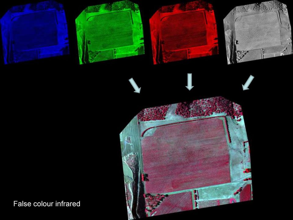
6 Sensors Sensors generally record data in four bands: blue; green; red; near infrared Three bands are used to create natural colour and false colour infrared images Two bands are used to create vegetation vigour maps Spectral bands can be either broad or narrow: Narrow band sensors are traditionally used in PV Wide band sensors are used in environmental mapping

7 Natural colour image

8 False colour infrared
9 Plant cell density (PCD)
")
10 Sensors Sensors generally record data in four bands: blue; green; red; near infrared Three bands are used to create natural colour and false colour infrared images Two bands are used to create vegetation vigour maps Spectral bands can be either broad or narrow: Narrow band sensors are traditionally used in PV Wide band sensors are used in environmental mapping

11 Narrow band sensors Blue Green Red NIR

12 Wide band sensors Blue Green Red NIR

13 Narrow band sensors Typical machine vision sensor Record in one band only (multiple cameras required for multispectral sensor) Require an appropriate filter Require custom software Small sensor (<10 megapixels) Physically small body Expensive ($2000 to $5000)
 Physically small body Expensive ($2000")
14 Narrow band sensors Array of narrow band sensors Spectral bands of a narrow band sensor array can be chosen to suit the application (viticulture, broad-acre ag etc.) Choice of bands is driven by scientific research

15 Wide band sensors Typical wide band camera Records in three broad, overlapping spectral bands (two cameras required for four band data) Small or large sensors (2Mp to 80Mp) Small or medium sized body Broad price range ($500 to $50,000)
 Small or medium sized body Broad price range")
16 Wide band sensors Typical wide band camera Modified off-the-shelf camera, so therefore it is difficult to choose spectral bands The spectral bands are driven by available technology, not scientific research

17 Narrow band vs. wide band Traditionally, narrow band sensors have been used for remote sensing (SpecTerra, Tetracam, Redlake / DuncanTech). Scientifically validated data Expensive to acquire and process data Today, there is movement away from narrow band sensors. Wide band sensors are commonly being used due to their accessibility. Little scientific validation of the data Cheap to acquire and process data Can easily be used on UAVs

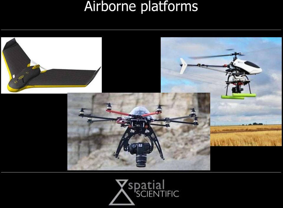
18 Airborne platforms Airborne platforms can be either manned or unmanned (drones) Problems with drones include: Payload Flight duration Weather (wind!) Legal issues Advantage of drones: Anyone can buy and fly one, and they re great fun!
 Legal issues Advantage of drones: Anyone can buy and fly")
19 Airborne platforms
20 Data processing GIS software is used to process aerial imagery ESRI ARCGIS has dominated the industry for decades, but it is expensive and difficult to use Nowadays, lots of cheap and even free GIS software is available (MapWindow, Global Mapper, Quantum GIS etc.) The cheaper software is much easier to use

21 Past vs. Future The past: The future: Data was acquired from scientific cameras on manned aircraft Data can be acquired from cheap cameras on drones The user had no control over the acquisition The user can control the process of acquisition and processing Processing was a skilled task GIS software is widely available The supplier set the rules The user will be able to set the rules
22 Remote sensing today Cheap drone + Modified off-the-shelf camera + Cheap and simple GIS software = Anyone can acquire and process multispectral data
23 What does this mean? The Positive view The Negative view Cheap cameras and cheap platforms means lower costs Cheap cameras and platforms will deliver poor quality data Growers have the freedom to choose when they fly data PV will cease to be driven by science Growers will develop products that really suit their needs Growers will loose confidence in remote sensing The whole industry will benefit The whole industry will suffer
24
Spectral Response for DigitalGlobe Earth Imaging Instruments
 Spectral Response for DigitalGlobe Earth Imaging Instruments IKONOS The IKONOS satellite carries a high resolution panchromatic band covering most of the silicon response and four lower resolution spectral
Digital Agriculture: Leveraging Technology and Information into Profitable Decisions
 Digital Agriculture: Leveraging Technology and Information into Profitable Decisions Dr. Matt Darr, Ag & Biosystems Engineering Advancing Agricultural Performance and Environmental Stewardship Some material
2.3 Spatial Resolution, Pixel Size, and Scale
 Section 2.3 Spatial Resolution, Pixel Size, and Scale Page 39 2.3 Spatial Resolution, Pixel Size, and Scale For some remote sensing instruments, the distance between the target being imaged and the platform,
From Pixel to Info-Cloud News at Leica Geosystems JACIE Denver, 31 March 2011 Ruedi Wagner Hexagon Geosystems, Geospatial Solutions Division.
 From Pixel to Info-Cloud News at Leica Geosystems JACIE Denver, 31 March 2011 Ruedi Wagner Hexagon Geosystems, Geospatial Solutions Division What else can I do with my sensor/data? Earth to Image Image
Resolutions of Remote Sensing
 Resolutions of Remote Sensing 1. Spatial (what area and how detailed) 2. Spectral (what colors bands) 3. Temporal (time of day/season/year) 4. Radiometric (color depth) Spatial Resolution describes how
SAMPLE MIDTERM QUESTIONS
 Geography 309 Sample MidTerm Questions Page 1 SAMPLE MIDTERM QUESTIONS Textbook Questions Chapter 1 Questions 4, 5, 6, Chapter 2 Questions 4, 7, 10 Chapter 4 Questions 8, 9 Chapter 10 Questions 1, 4, 7
Contributions of the geospatial fields to monitoring sustainability of urban environments John Trinder. School of Civil and Environmental Engineering
 Contributions of the geospatial fields to monitoring sustainability of urban environments John Trinder School of Civil and Environmental Engineering 2 IMPACT OF HUMAN DEVELOPMENT Humans are modifying the
The YellowScan system: A test on the oppida of Nages/Roque de Viou (Languedoc, France) Tristan Allouis, PhD Research and Development, L'Avion Jaune
 Tristan Allouis, PhD Research and Development, L'Avion Jaune") The YellowScan system: A test on the oppida of Nages/Roque de Viou (Languedoc, France) Tristan Allouis, PhD Research and Development, L'Avion Jaune L'Avion Jaune : Earth observation data provider UAVs
The YellowScan system: A test on the oppida of Nages/Roque de Viou (Languedoc, France) Tristan Allouis, PhD Research and Development, L'Avion Jaune L'Avion Jaune : Earth observation data provider UAVs
Adding Data from APFO s Public ArcGIS Server into ArcMap 10.x. The short instructions for accessing this service consist of stating that
 Adding Data from APFO s Public ArcGIS Server into ArcMap 10.x APFO provides the most current year of NAIP imagery, as well as satellite imagery for Hawaii, in a web service for public users. There are
TAMU-CC UAS Program 1
 TAMU-CC UAS Program 1 TAMU-CC Major Research Initiatives Coastal & Marine Economic & environmental sustainability Ecosystem evaluation Shoreline mapping Water supply studies Policy Engineering Science
Opportunities for the generation of high resolution digital elevation models based on small format aerial photography
 Opportunities for the generation of high resolution digital elevation models based on small format aerial photography Boudewijn van Leeuwen 1, József Szatmári 1, Zalán Tobak 1, Csaba Németh 1, Gábor Hauberger
Big Data & Big Opportunities
 Big Data & Big Opportunities Dr. Matt Darr, Iowa State University For a copy of this slide deck please send an email request to [email protected] Presentation Guiding Principles No intent to be critical
ENVI THE PREMIER SOFTWARE FOR EXTRACTING INFORMATION FROM GEOSPATIAL IMAGERY.
 ENVI THE PREMIER SOFTWARE FOR EXTRACTING INFORMATION FROM GEOSPATIAL IMAGERY. ENVI Imagery Becomes Knowledge ENVI software uses proven scientific methods and automated processes to help you turn geospatial
Photogrammetric Point Clouds
 Photogrammetric Point Clouds Origins of digital point clouds: Basics have been around since the 1980s. Images had to be referenced to one another. The user had to specify either where the camera was in
SPOT Satellite Earth Observation System Presentation to the JACIE Civil Commercial Imagery Evaluation Workshop March 2007
 SPOT Satellite Earth Observation System Presentation to the JACIE Civil Commercial Imagery Evaluation Workshop March 2007 Topics Presented Quick summary of system characteristics Formosat-2 Satellite Archive
Supervised Classification workflow in ENVI 4.8 using WorldView-2 imagery
 Supervised Classification workflow in ENVI 4.8 using WorldView-2 imagery WorldView-2 is the first commercial high-resolution satellite to provide eight spectral sensors in the visible to near-infrared
Computer Vision: Machine Vision Filters. Computer Vision. Optical Filters. 25 August 2014
 Computer Vision Optical Filters 25 August 2014 Copyright 2001 2014 by NHL Hogeschool, Van de Loosdrecht Machine Vision BV and Klaas Dijkstra All rights reserved [email protected], [email protected],
Understanding Raster Data
 Introduction The following document is intended to provide a basic understanding of raster data. Raster data layers (commonly referred to as grids) are the essential data layers used in all tools developed
MULTIPURPOSE USE OF ORTHOPHOTO MAPS FORMING BASIS TO DIGITAL CADASTRE DATA AND THE VISION OF THE GENERAL DIRECTORATE OF LAND REGISTRY AND CADASTRE
 MULTIPURPOSE USE OF ORTHOPHOTO MAPS FORMING BASIS TO DIGITAL CADASTRE DATA AND THE VISION OF THE GENERAL DIRECTORATE OF LAND REGISTRY AND CADASTRE E.ÖZER, H.TUNA, F.Ç.ACAR, B.ERKEK, S.BAKICI General Directorate
USE OF VERY HIGH-RESOLUTION AIRBORNE IMAGES TO ANALYSE 3D CANOPY ARCHITECTURE OF A VINEYARD
 USE OF VERY HIGH-RESOLUTION AIRBORNE IMAGES TO ANALYSE 3D CANOPY ARCHITECTURE OF A VINEYARD S. Burgos a, *, M. Mota a, D. Noll a, B. Cannelle b a University for Viticulture and Oenology Changins, 1260
Introduction to Imagery and Raster Data in ArcGIS
 Esri International User Conference San Diego, California Technical Workshops July 25, 2012 Introduction to Imagery and Raster Data in ArcGIS Simon Woo slides Cody Benkelman - demos Overview of Presentation
Precision Farming and the Future of Crop Production
 Precision Farming and the Future of Crop Production Ron Milby Executive Director, Agronomy Marketing Technology Advancements Tillage Harvest 30 Acres per Hour Plant 80 Acres per Hour Enabling Technologies
TerraColor White Paper
 TerraColor White Paper TerraColor is a simulated true color digital earth imagery product developed by Earthstar Geographics LLC. This product was built from imagery captured by the US Landsat 7 (ETM+)
Review for Introduction to Remote Sensing: Science Concepts and Technology
 Review for Introduction to Remote Sensing: Science Concepts and Technology Ann Johnson Associate Director [email protected] Funded by National Science Foundation Advanced Technological Education program [DUE
The University of Florida Unmanned Aircraft Systems Research Program: Lessons Learned and an Update on Selected Natural Resources Applications
 The University of Florida Unmanned Aircraft Systems Research Program: Lessons Learned and an Update on Selected Natural Resources Applications Matthew A. Burgess R.R. Carthy, B.E. Wilkinson, T.J. Whitley,
Remote sensing is the collection of data without directly measuring the object it relies on the
 Chapter 8 Remote Sensing Chapter Overview Remote sensing is the collection of data without directly measuring the object it relies on the reflectance of natural or emitted electromagnetic radiation (EMR).
The Concept of Apps as a Tool to Improve Innovation in e-navigation
 http://www.transnav.eu the International Journal on Marine Navigation and Safety of Sea Transportation Volume 9 Number 3 September 2015 DOI: 10.12716/1001.09.03.17 The Concept of Apps as a Tool to Improve
Connecting the World from the Sky
 Connecting the World from the Sky Last August, Facebook partnered with leading technology companies to launch Internet.org a global effort to make affordable basic internet services available to everyone
How To Discuss Unmanned Aircraft System (Uas)
") Unmanned Aerial Systems (UAS) for American Association of Port Authorities Administration and Legal Issues Seminar New Orleans, LA April 9, 2015 Briefly about Flight Guardian Our Services: Educating public
Unmanned Aerial Systems (UAS) for American Association of Port Authorities Administration and Legal Issues Seminar New Orleans, LA April 9, 2015 Briefly about Flight Guardian Our Services: Educating public
White paper. CCD and CMOS sensor technology Technical white paper
 White paper CCD and CMOS sensor technology Technical white paper Table of contents 1. Introduction to image sensors 3 2. CCD technology 4 3. CMOS technology 5 4. HDTV and megapixel sensors 6 5. Main differences
Hyperspectral Satellite Imaging Planning a Mission
 Hyperspectral Satellite Imaging Planning a Mission Victor Gardner University of Maryland 2007 AIAA Region 1 Mid-Atlantic Student Conference National Institute of Aerospace, Langley, VA Outline Objective
Nighthawk IV UAS. Versatility. User Friendly Design. Capability. Aerial Surveillance Simplified. [email protected] 800.639.6315 www.ara.
 Aerial Surveillance Simplified The Nighthawk IV small unmanned aerial vehicle brings military hardened technology to civil agencies and commercial user groups. Supremely easy to operate and recently certified
Color image processing: pseudocolor processing
 Color image processing: pseudocolor processing by Gleb V. Tcheslavski: [email protected] http://ee.lamar.edu/gleb/dip/index.htm Spring 2008 ELEN 4304/5365 DIP 1 Preliminaries Pseudocolor (false color)
Design Specifications of an UAV for Environmental Monitoring, Safety, Video Surveillance, and Urban Security
 Design Specifications of an UAV for Environmental Monitoring, Safety, Video Surveillance, and Urban Security A. Alessandri, P. Bagnerini, M. Gaggero, M. Ghio, R. Martinelli University of Genoa - Faculty
Land Use/Land Cover Map of the Central Facility of ARM in the Southern Great Plains Site Using DOE s Multi-Spectral Thermal Imager Satellite Images
 Land Use/Land Cover Map of the Central Facility of ARM in the Southern Great Plains Site Using DOE s Multi-Spectral Thermal Imager Satellite Images S. E. Báez Cazull Pre-Service Teacher Program University
Using Technology and Big Data to Improve Profits. Matt Darr, Agricultural & Biosystems Engineering
 Using Technology and Big Data to Improve Profits Matt Darr, Agricultural & Biosystems Engineering 2015 THE YEAR OF BIG DATA Why the New Emphasis on Data Today? Autosteering and swath control technology
INTA AIRBORNE REMOTE SENSING FACILITY from the Hasselblad s cameras to the SensyTech-AHS sensor
 INTA AIRBORNE REMOTE SENSING FACILITY from the Hasselblad s cameras to the SensyTech-AHS sensor José-Antonio Gómez-Sánchez [email protected] Remote Sensing Laboratory INSTITUTO NACIONAL DE TÉCNICA AEROESPACIAL
UAV Road Surface Monitoring and Traffic Information
 UAV Road Surface Monitoring and Traffic Information Czech Road and Motorway Network New capabilities for Unmanned Aerial Systems Current usage (military operation service) Possible civil usage (possible
The premier software for extracting information from geospatial imagery.
 Imagery Becomes Knowledge ENVI The premier software for extracting information from geospatial imagery. ENVI Imagery Becomes Knowledge Geospatial imagery is used more and more across industries because
Big Data and Analytics: A Conceptual Overview. Mike Park Erik Hoel
 Big Data and Analytics: A Conceptual Overview Mike Park Erik Hoel In this technical workshop This presentation is for anyone that uses ArcGIS and is interested in analyzing large amounts of data We will
Image Draping & navigation within Virtual GIS
 Image Draping & navigation within Virtual GIS Draping of Geo Corrected data such as aerial imagery or map data enables virtual 3D field tours to be conducted in an area of interest. This document covers
DRONE DETECTION RADAR
 DRONE DETECTION RADAR MEETING TODAY S CHALLENGES Drones are increasingly becoming wide spread. They ve become affordable, easy to obtain and simple to fly. This creates new opportunities, but also poses
UAS as a platform for integrated sensing and big data
 Unmanned Aerial Systems in Precision Agriculture Thursday 30 th January 2014 UAS as a platform for integrated sensing and big data Prof Anthony Furness Visiting Professor Dr Tomas Norton, Senior Lecturer
Landsat Monitoring our Earth s Condition for over 40 years
 Landsat Monitoring our Earth s Condition for over 40 years Thomas Cecere Land Remote Sensing Program USGS ISPRS:Earth Observing Data and Tools for Health Studies Arlington, VA August 28, 2013 U.S. Department
Mr. Jay Arnold, Magnolia River Mr. Richard Vincent, McKim & Creed
 Mr. Jay Arnold, Magnolia River Mr. Richard Vincent, McKim & Creed Why Change? Electric Utility Safety and Reliability NERC FAC- 008 and FAC-003 As Built Infrastructure monitor vegetation annual requirement
Digital Remote Sensing Data Processing Digital Remote Sensing Data Processing and Analysis: An Introduction and Analysis: An Introduction
 Digital Remote Sensing Data Processing Digital Remote Sensing Data Processing and Analysis: An Introduction and Analysis: An Introduction Content Remote sensing data Spatial, spectral, radiometric and
AeroVironment, Inc. Unmanned Aircraft Systems Overview Background
 AeroVironment, Inc. Unmanned Aircraft Systems Overview Background AeroVironment is a technology solutions provider with a more than 40-year history of practical innovation in the fields of unmanned aircraft
Mapping coastal landscapes in Sri Lanka - Report -
 Mapping coastal landscapes in Sri Lanka - Report - contact : Jil Bournazel [email protected] November 2013 (reviewed April 2014) Table of Content List of Figures...ii List of Tables...ii Acronyms...ii
Remote sensing and GIS applications in coastal zone monitoring
 Remote sensing and GIS applications in coastal zone monitoring T. Alexandridis, C. Topaloglou, S. Monachou, G.Tsakoumis, A. Dimitrakos, D. Stavridou Lab of Remote Sensing and GIS School of Agriculture
Use of RPAS/Drones in Norway
 Use of RPAS/Drones in Norway Publisert: 23 mai 2016 13:05 CEST Oppdatert: 08 jun 2016 09:56 CEST Send på epost About Drones Drones Use of drones, or RPAS (Remotely piloted aircraft system) is regulated
High speed 3D capture for Configuration Management DOE SBIR Phase II Paul Banks [email protected]
 High speed 3D capture for Configuration Management DOE SBIR Phase II Paul Banks [email protected] Advanced Methods for Manufacturing Workshop September 29, 2015 1 TetraVue does high resolution 3D
The USGS Landsat Big Data Challenge
 The USGS Landsat Big Data Challenge Brian Sauer Engineering and Development USGS EROS [email protected] U.S. Department of the Interior U.S. Geological Survey USGS EROS and Landsat 2 Data Utility and Exploitation
Field Techniques Manual: GIS, GPS and Remote Sensing
 Field Techniques Manual: GIS, GPS and Remote Sensing Section A: Introduction Chapter 1: GIS, GPS, Remote Sensing and Fieldwork 1 GIS, GPS, Remote Sensing and Fieldwork The widespread use of computers
METIER Course No. 6: Remote Sensing & Hydrosphere Helsinki 6 November 2008 Kati Tahvonen Finnish Environment Institute
 The Use of Remote Sensing, Drifting Forecasts and GIS Data in Oil Response and Pollution Monitoring METIER Course No. 6: Remote Sensing & Hydrosphere Helsinki 6 November 2008 Kati Tahvonen Finnish Environment
High Resolution Digital Surface Models and Orthoimages for Telecom Network Planning
 Renouard, Lehmann 241 High Resolution Digital Surface Models and Orthoimages for Telecom Network Planning LAURENT RENOUARD, S ophia Antipolis FRANK LEHMANN, Berlin ABSTRACT DLR of Germany and ISTAR of
Development of Automatic shooting and telemetry system for UAV photogrammetry INTRODUCTION
 Development of Automatic shooting and telemetry system for UAV photogrammetry Jinwoo PARK 1, Minseok KIM 1, Khin Mar Yee 1, Chuluong CHOI 1 1 Department of Spatial Information Engineering, Pukyong National
'Developments and benefits of hydrographic surveying using multispectral imagery in the coastal zone
 Abstract With the recent launch of enhanced high-resolution commercial satellites, available imagery has improved from four-bands to eight-band multispectral. Simultaneously developments in remote sensing
ITEM FOR FINANCE COMMITTEE
 For discussion on 12 June 2009 FCR(2009-10)24 ITEM FOR FINANCE COMMITTEE HEAD 166 - GOVERNMENT FLYING SERVICE Subhead 603 Plant, vehicles and equipment New Item Replacement of two fixed-wing aircraft and
How Landsat Images are Made
 How Landsat Images are Made Presentation by: NASA s Landsat Education and Public Outreach team June 2006 1 More than just a pretty picture Landsat makes pretty weird looking maps, and it isn t always easy
Remote Sensing Applications for Precision Agriculture
 Remote Sensing Applications for Precision Agriculture Farm Progress Show Chris J. Johannsen, Paul G. Carter and Larry L. Biehl Department of Agronomy and Laboratory for Applications of Remote Sensing (LARS)
Bachelor of Geospatial Science Inaugural intake 2015
 Bachelor of Geospatial Science Inaugural intake 2015 Aleen Prasad and Dr Nick Rollings Geospatial Science Unit School of Geography, Earth Science and Environment The University of the South Pacific Geospatial
Author: By Siegfried Krainer and Michael Thomas, Infineon Technologies and Ronald Staerz, MCI Innsbruck
 From toys to tools Author: By Siegfried Krainer and Michael Thomas, Infineon Technologies and Ronald Staerz, MCI Innsbruck Date: 05/04/2016 Categories: Evaluation & Development Kits, Internet of things
China Earth Observation
 China High-resolution Earth Observation China Earth Observation System (CHEOS) and its Lastest Development The Earth Observation System and Data Center, CNSA 2014-2 Outlines 1 Introduction 2 The composition
Joint Polar Satellite System (JPSS)
") Joint Polar Satellite System (JPSS) John Furgerson, User Liaison Joint Polar Satellite System National Environmental Satellite, Data, and Information Service National Oceanic and Atmospheric Administration
Joint Polar Satellite System (JPSS) John Furgerson, User Liaison Joint Polar Satellite System National Environmental Satellite, Data, and Information Service National Oceanic and Atmospheric Administration
INVESTIGA I+D+i 2013/2014
 INVESTIGA I+D+i 2013/2014 SPECIFIC GUIDELINES ON AEROSPACE OBSERVATION OF EARTH Text by D. Eduardo de Miguel October, 2013 Introducction Earth observation is the use of remote sensing techniques to better
Selecting the appropriate band combination for an RGB image using Landsat imagery
 Selecting the appropriate band combination for an RGB image using Landsat imagery Ned Horning Version: 1.0 Creation Date: 2004-01-01 Revision Date: 2004-01-01 License: This document is licensed under a
EVALUATION OF AIRBORNE LIDAR DIGITAL TERRAIN MAPPING FOR HIGHWAY CORRIDOR PLANNING AND DESIGN
 Waheed Uddin Director, Center for Advanced Infrastructure Technology, Carrier Hall 203 The University of Mississippi, University, MS 38677-1848, USA [email protected] KEY WORDS: Terrain, mapping, airborne,
ANALYSIS OF FOREST CHANGE IN FIRE DAMAGE AREA USING SATELLITE IMAGES
 ANALYSIS OF FOREST CHANGE IN FIRE DAMAGE AREA USING SATELLITE IMAGES Joon Mook Kang, Professor Joon Kyu Park, Ph.D Min Gyu Kim, Ph.D._Candidate Dept of Civil Engineering, Chungnam National University 220
How To Make An Orthophoto
 ISSUE 2 SEPTEMBER 2014 TSA Endorsed by: CLIENT GUIDE TO DIGITAL ORTHO- PHOTOGRAPHY The Survey Association s Client Guides are primarily aimed at other professionals such as engineers, architects, planners
GEOGRAPHIC INFORMATION SYSTEMS Lecture 20: Adding and Creating Data
 Adding Existing Data Into ArcGIS - there are many different ways to get data into ArcGIS GEOGRAPHIC INFORMATION SYSTEMS Lecture 20: Adding and Creating Data Add Data - normally we use the Add Data button
Demystifying CLOUD COMPUTING
 Demystifying CLOUD COMPUTING for Remote Sensing Applications Cloud computing is a powerful, unique value proposition that can transform massive Earth imagery datasets into useful information for users
Application for Special Flight Operations Certificate Standing Restricted Operator - Complex Application Process File # AA-01012015-01
 Application for Special Flight Operations Certificate Standing Restricted Operator - Complex Application Process File # AA-01012015-01 Operator Name Address City, Province Postal Code P 902 555-1212 E
CONTENTS. Overview. Profile. Drones/UAVs. Batteries. Equipment. Customers
 User Manual 2016 CONTENTS Overview 0.1 Drone Logbook Overview... 5 0.2 Upgrading your Account... 6 0.3 Retrieving your Password... 7 0.4 Changing Your Password... 7 0.6 Main Dashboard... 7 Profile 1.1
Advanced Image Management using the Mosaic Dataset
 Esri International User Conference San Diego, California Technical Workshops July 25, 2012 Advanced Image Management using the Mosaic Dataset Vinay Viswambharan, Mike Muller Agenda ArcGIS Image Management
Hydrographic Surveying using High Resolution Satellite Images
 Hydrographic Surveying using High Resolution Satellite Images Petra PHILIPSON and Frida ANDERSSON, Sweden Key words: remote sensing, high resolution, hydrographic survey, depth estimation. SUMMARY The
WHITE PAPER. Are More Pixels Better? www.basler-ipcam.com. Resolution Does it Really Matter?
 WHITE PAPER www.basler-ipcam.com Are More Pixels Better? The most frequently asked question when buying a new digital security camera is, What resolution does the camera provide? The resolution is indeed
ArcGIS Agricultural Land Use Maps from the Mississippi Cropland Data Layer
 ArcGIS Agricultural Land Use Maps from the Mississippi Cropland Data Layer Fred L. Shore, Ph.D. Mississippi Department of Agriculture and Commerce Jackson, MS, USA [email protected] Rick Mueller
SatelliteRemoteSensing for Precision Agriculture
 SatelliteRemoteSensing for Precision Agriculture Managing Director WasatSp. z o.o. Copernicus the road to economic development Warsaw, 26-27 February 2015 Activitiesof WasatSp. z o.o. The company provides
Tracking devices. Important features. 6 Degrees of freedom. Mechanical devices. Types. Virtual Reality Technology and Programming
 Tracking devices Virtual Reality Technology and Programming TNM053: Lecture 4: Tracking and I/O devices Referred to head-tracking many times Needed to get good stereo effect with parallax Essential for
RESOLUTION MERGE OF 1:35.000 SCALE AERIAL PHOTOGRAPHS WITH LANDSAT 7 ETM IMAGERY
 RESOLUTION MERGE OF 1:35.000 SCALE AERIAL PHOTOGRAPHS WITH LANDSAT 7 ETM IMAGERY M. Erdogan, H.H. Maras, A. Yilmaz, Ö.T. Özerbil General Command of Mapping 06100 Dikimevi, Ankara, TURKEY - (mustafa.erdogan;
GIS and Remote Sensing in Diachronic Study of Agriculture in Greece
 GIS and Remote Sensing in Diachronic Study of Agriculture in Greece Maria Androulidaki a, Michail Salampasis b, Vagis Samathrakis c, Christos Batzios d a Alexander Technology Educational Institute of Thessaloniki,
Using Remote Sensing Imagery to Evaluate Post-Wildfire Damage in Southern California
 Graham Emde GEOG 3230 Advanced Remote Sensing February 22, 2013 Lab #1 Using Remote Sensing Imagery to Evaluate Post-Wildfire Damage in Southern California Introduction Wildfires are a common disturbance
Mapping Solar Energy Potential Through LiDAR Feature Extraction
 Mapping Solar Energy Potential Through LiDAR Feature Extraction WOOLPERT WHITE PAPER By Brad Adams [email protected] DESIGN GEOSPATIAL INFRASTRUCTURE November 2012 Solar Energy Potential Is Largely
Digital Image Increase
 Exploiting redundancy for reliable aerial computer vision 1 Digital Image Increase 2 Images Worldwide 3 Terrestrial Image Acquisition 4 Aerial Photogrammetry 5 New Sensor Platforms Towards Fully Automatic
Mapping Mashup/Data Integration Development Resources
 Mapping Mashup/Data Integration Development Resources David Hart GIS Specialist University of Wisconsin Sea Grant Institute October 6, 2008 Virtual Globes A virtual globe is a 3D software model or representation
WATER BODY EXTRACTION FROM MULTI SPECTRAL IMAGE BY SPECTRAL PATTERN ANALYSIS
 WATER BODY EXTRACTION FROM MULTI SPECTRAL IMAGE BY SPECTRAL PATTERN ANALYSIS Nguyen Dinh Duong Department of Environmental Information Study and Analysis, Institute of Geography, 18 Hoang Quoc Viet Rd.,
Cultivating Agricultural Information Management System Using GIS Technology
 Hitachi Review Vol. 58 (2009), No. 6 265 Cultivating Agricultural Information Management System Using GIS Technology Improving Agricultural Efficiency through Information Technology Osamu Nishiguchi Noriko
River Flood Damage Assessment using IKONOS images, Segmentation Algorithms & Flood Simulation Models
 River Flood Damage Assessment using IKONOS images, Segmentation Algorithms & Flood Simulation Models Steven M. de Jong & Raymond Sluiter Utrecht University Corné van der Sande Netherlands Earth Observation
Mapping Earth from Space Remote sensing and satellite images. Remote sensing developments from war
 Mapping Earth from Space Remote sensing and satellite images Geomatics includes all the following spatial technologies: a. Cartography "The art, science and technology of making maps" b. Geographic Information
Satellite-Based Earth Observation (EO), 7th Edition
, 7th Edition") Satellite-Based Earth Observation (EO), 7th Edition Report Brief www.nsr.com 2013 NSR Report Description NSR s Satellite-Based Earth Observation (EO), 7th Edition is the industry-leading analysis of the
Satellite-Based Earth Observation (EO), 7th Edition Report Brief www.nsr.com 2013 NSR Report Description NSR s Satellite-Based Earth Observation (EO), 7th Edition is the industry-leading analysis of the
Integration of Drones in Civil Airspace
 Integration of Drones in Civil Airspace «Game of Drones» Catherine Ronflé-Nadaud February 2016 www.developpement-durable.gouv.fr DGAC /DSNA /DTI French Air Navigation Service Provider is responsible for