Weed Survey and Mapping
|
|
|
- Abraham James
- 9 years ago
- Views:
Transcription
1 Weed Survey and Mapping The primary objective of weed surveying and mapping is to accurately identify and delineate land with populations of invasive plants or noxious weeds. These surveys allow land managers to predict areas that are potentially subject to weed invasion; to understand the biology of the invasion process and determine means by which weeds spread; to develop, implement, and evaluate weed management plans; to assess the economic impact of weed invasions; and to increase public awareness, education, and weed management efforts. Weed survey information is collected and compiled into maps showing the distribution and severity of the infestations. Weed monitoring involves repetitive surveys to track weed populations over time. A standardized system of weed surveying and mapping is necessary to provide consistently reliable information that can be compared from year to year. Additional information on data recording methods, computer mapping systems, the Global Positioning System (GPS), combining data collected by different methods, software compatibility considerations, and digital base layers available for computer mapping can be found in the publication Mapping Noxious Weeds in Montana, Extension Bulletin 148, 1998, available from the Montana State University Cooperative Extension Service Mailing Room ( ). Objectives of a Weed Survey and Mapping System To collect information on weed biology and ecology, including location and acreage infested, growth requirements, and spread patterns and rates. Use of data for developing weed management goals and objectives. Establishing a historical database. Evaluation of the progress of a weed management program. Increase public awareness and support for the program. I. Survey Field Methods A. Factors Influencing Survey Detail. 1. Management objectives of the WMA: Surveys can be used to develop baseline information for regional databases, county-wide inventories, local cooperative weed management areas, and eradication programs. 21 Weed Survey & Mapping

2 Visual scan of the area (Level III) Perimeter mapping method (Level II) Grid mapping for detailed inventories (Level I) 2. Time constraints of personnel involved in the WMA. 3. Funding and resources of WMA cooperators. 4. Terrain of the WMA. B. Level of Survey: The level of weed survey utilized is based on the objectives of the weed inventory. 1. Regional and planning weed inventories (Level III): These are reconnaissance surveys used to develop general planning guidelines over large acreages. a. This is the most effective survey for initial planning in a WMA. b. Utilize existing information, including interviews with cooperating landowners, aerial surveys, or windshield surveys. c. Hand-drawn infestations boundaries on 7 1 /2 to 15 minute topographic maps are acceptable maps for this level. d. Digitize data into a computer mapping system such as Arc View or County CAD. e. This survey is the most economical but the overall level of accuracy is reduced. 2. Local cooperative projects and county-wide inventories (Level II): These surveys are of moderate detail and accuracy. a. This survey level is best for development of containment and control projects. It is suggested for developing specific management plans within the WMA. b. Hand-drawn infestations boundaries on 7 1 / 2 minute (1:24,000 map scale) are acceptable maps for this level. c. Digitize data into a GIS database such as Arc View or CAD mapping system. d. GPS is not necessary for Level II mapping. e. The costs associated with this survey are of a moderate level. 3. Eradication program inventories (Level I): These surveys are useful when a high level of accuracy and detail is required. a. This survey is most effectively used for the detection of newly invading species or to develop weed eradication programs. b. Survey methods are based on grid systems. c. GPS and GIS systems are highly recommended. 22 Weed Survey & Mapping

3 II. Mapping Procedures d. This survey is most expensive in terms of both time and dollars. C. Mapping Hints. 1. Study aerial photographs, topographic maps, and historical weed data to determine limiting terrain and areas where weeds have been located in the past. 2. Identify high probability areas where weed infestations are most likely to start, such as trailhead areas, high traffic areas, disturbed sites, etc. 3. Identify reported weed infestations on the map. 4. Delineate boundaries of the inventory area. 5. Be realistic about what you can accomplish. 6. Conduct the inventory when weeds are most visible, during full flower or in the fall. 7. Don t inventory more than two species at a time unless infestations are very small and isolated. 8. Develop a search pattern based on the objectives of the inventory. D. Equipment Needs. 1. Method of transportation, based on area: 4x4 vehicle, ATV, horses. 2. Maps. 3. Clipboard and color pencils. 4. Two-way radio. 5. Fishing or photography vest. 6. Binoculars. 7. GPS unit (optional). E. Summary. 1. Follow a standardized mapping procedure that outlines acreage symbols, weed color codes, and cover class (such as the Montana Mapping Standards) that is agreeable to all cooperators in the WMA. 2. Determine the level of inventory necessary to meet weed management goals and objectives. 3. Develop realistic objectives for the inventory based on funding, time, and terrain. 4. Schedule the inventory when weeds are most visible. 5. Keep inventory areas well defined. 6. Keep inventory methods simple. 7. Remember that weed inventories are a continual update process. A. Establish Weed Management Area(s). These areas will be delineated through coordination between county weed dis- 23 Weed Survey & Mapping

4 III. Infestation Delineation tricts and the WMA cooperators. WMAs are land units that have similar characteristics such as geography, weed problems, climate, or common interest and funding support. Boundaries may be a watershed divide or other geographic feature. This eliminates jurisdictional boundaries that are barriers to effective weed control in favor of natural boundaries that are barriers to the spread of weeds. B. Complete noxious weed management maps and an inventory of the weeds in the WMA. 1. Weed survey maps may be created by hand-drawing infestation boundaries on base maps, using a computerized mapping system, such as Arc View or County CAD, or by collecting location coordinates of weed infestations using Global Positioning System (GPS) technology. 2. When weed infestations are hand-drawn on base maps, USGS 1:24,000 scale (7 1 /2 minute series) maps should be used. 3. In areas where detailed soil surveys have been completed, aerial photographs may be available (contact the Natural Resources Conservation Service for information). Aerial photographs show good detail and can be used to locate your position and draw in surveyed weed infestations. 4. Aerial photos and maps must be geodetically corrected for weed data to be digitized into a GIS database. C. Certain features should be common to all noxious weed management maps. Use clear overlays to show additional features. The base maps should show: 1. Weed infestations by species. 2. Topographic features. 3. Man-made features, such as roads, trails, power lines, railroads, irrigation canals, and ditch systems. 4. Jurisdictional boundaries, such as state lands, federal lands, cemeteries, etc. 5. Vegetative types and soil types. 6. Sensitive areas, such as wetlands, distance to groundwater, and threatened, endangered and sensitive species. Weeds should be delineated by a standardized method of marking infestation locations, acreage estimates, and level of infestation by individual species. A. Procedure. 24 Weed Survey & Mapping

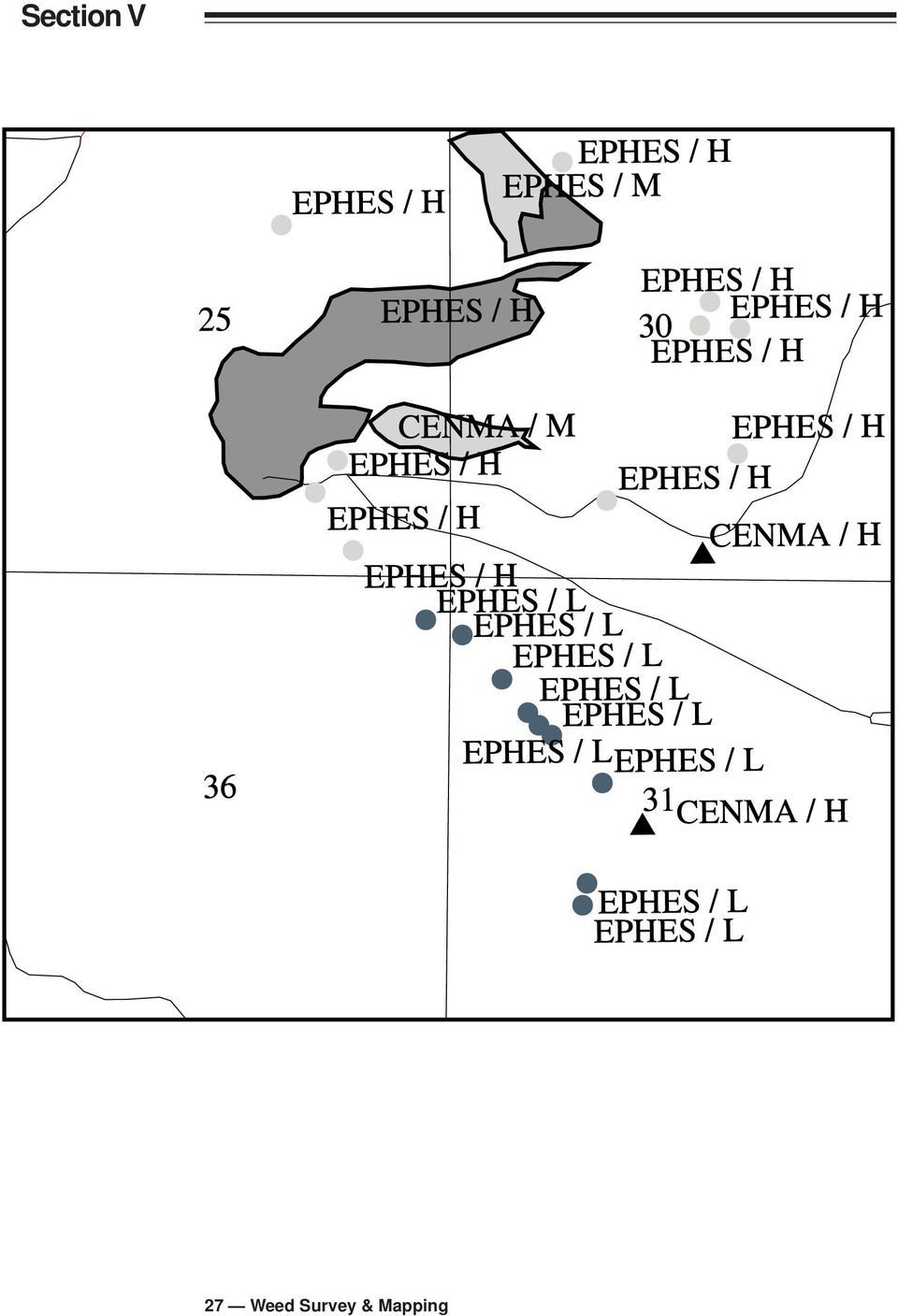
5 1. Map weed infestations using the following symbols on the mapped area to indicate approximate size and location of the infestation. 0 = area was mapped, no weed infestations found x = less than 0.1 of an acre = 0.1 to 1 acre = 1 to 5 acres _ = areas larger than 5 acres should be outlined directly on the map ~ = infestations that follow linear features such as roads and streams should be designated by drawing lines on the map 2. Five letter WSSA codes or other approved designations should be used to indicate the weed species. (See Appendix 13.) 3. Color codes may be used on local maps to make infestations more visible. Make sure the color key is included on the map. 4. Use the following symbols to indicate the infestation level (cover class): T = Trace (rare): less than 1% cover L = Low (occasional plants): between 1 and 5% cover M = Moderate (scattered plants): between 5 and 25% cover H = High (fairly dense): greater than 25% cover B. Baseline Information: Weed Database Programs 1. A good inventory of baseline data provides WMA cooperators information to help evaluate weed management options. A list of important elements can be found in Appendix Weed database programs can be used to help chart progress in the WMA and assist in planning and budgeting an effective multi-year plan. Databases give uniformity to data entry, better organized information storage, and easy retrieval of data. They can be used to monitor infestation trends and treatment and can be used as a planning tool. a. Many land management agencies have developed effective databases to track weed management programs. References can be found in Appendix All maps to be digitized should be accompanied by a metadata form. See Appendix 9 for an example. 25 Weed Survey & Mapping
 3.")
6 Point Infestations <0.1 acre 0.1 to 1 acre 1 to 5 acres Line Infestations Area Infestations Cover Class T - Trace L - Low M - Moderate H - High Point Line Area Feature Type Summary Acres Weed Survey & Mapping

7 27 Weed Survey & Mapping
Wildlife Habitat Conservation and Management Plan
 Wildlife Habitat Conservation and Management Plan For [Applicant Name] [Insert photo of property] Developed in Cooperation with Jane Doe Habitat Conservation Biologist Oregon Department of Fish and Wildlife
WEED MANAGEMENT PLAN FOR. (NAME of PROPERTY or MANAGED AREA) (TOWN or COUNTY, STATE) (TIME PERIOD; e.g. 1996-2000)
 (TOWN or COUNTY, STATE) (TIME PERIOD; e.g. 1996-2000)") (WEED MANAGEMENT PLAN OUTLINE FOR PUBLIC LAND MANAGERS) (Note: This outline is a modification of a weed management plan template produced by The Nature Conservancy) WEED MANAGEMENT PLAN FOR (NAME of PROPERTY
(WEED MANAGEMENT PLAN OUTLINE FOR PUBLIC LAND MANAGERS) (Note: This outline is a modification of a weed management plan template produced by The Nature Conservancy) WEED MANAGEMENT PLAN FOR (NAME of PROPERTY
Natural Resource-Based Planning*
 Natural Resource-Based Planning* Planning, when done well, is among the most powerful tools available to communities. A solid plan, based on good natural resource information, guides rational land-use
MINIMUM STANDARDS FOR ACCEPTANCE OF AQUATIC RESOURCES DELINEATION REPORTS
 MINIMUM STANDARDS FOR ACCEPTANCE OF AQUATIC RESOURCES DELINEATION REPORTS U.S. ARMY CORPS OF ENGINEERS BUILDING STRONG January 2016 The U.S Army Corps of Engineers, through its Regulatory Program, regulates
Colorado Natural Heritage Program
 CNHP s mission is to preserve the natural diversity of life by contributing the essential scientific foundation that leads to lasting conservation of Colorado's biological wealth. Colorado Natural Heritage
AERIAL PHOTOGRAPHS. For a map of this information, in paper or digital format, contact the Tompkins County Planning Department.
 AERIAL PHOTOGRAPHS What are Aerial Photographs? Aerial photographs are images of the land taken from an airplane and printed on 9 x9 photographic paper. Why are Aerial Photographs Important? Aerial photographs
Using Aerial Photography to Measure Habitat Changes. Method
 Then and Now Using Aerial Photography to Measure Habitat Changes Method Subject Areas: environmental education, science, social studies Conceptual Framework Topic References: HIIIB, HIIIB1, HIIIB2, HIIIB3,
SANTA BARBARA COUNTY COMPREHENSIVE PLAN LOMPOC AREA
 SANTA BARBARA COUNTY COMPREHENSIVE PLAN LOMPOC AREA A. LAND USE ELEMENT INTERPRETIVE GUIDELINES B. COMMUNITY BENEFITS C. COUNTY ACTION ITEMS Adopted by the Board of Supervisors November 9, 1999 A. Santa
Rural Residential Buildable Lands Inventory
 The Dalles Periodic Review, May 2013 Rural Residential Lands Inventory Contents Introduction and Summary... 1 Concerns related to the 2007 Analysis... 2 Rural Residential Capacity Summary... 2 Methodology...
WHAT IS GIS - AN INRODUCTION
 WHAT IS GIS - AN INRODUCTION GIS DEFINITION GIS is an acronym for: Geographic Information Systems Geographic This term is used because GIS tend to deal primarily with geographic or spatial features. Information
CIESIN Columbia University
 Conference on Climate Change and Official Statistics Oslo, Norway, 14-16 April 2008 The Role of Spatial Data Infrastructure in Integrating Climate Change Information with a Focus on Monitoring Observed
TAMARISK MAPPING & MONITORING USING HIGH RESOLUTION SATELLITE IMAGERY. Jason W. San Souci 1. John T. Doyle 2
 TAMARISK MAPPING & MONITORING USING HIGH RESOLUTION SATELLITE IMAGERY Jason W. San Souci 1 John T. Doyle 2 ABSTRACT QuickBird high resolution multispectral satellite imagery (60 cm GSD, 4 spectral bands)
REFERENCE. All National Grid personnel who plan and perform work involving protected water resources are responsible for:
 EG-30NY ENVIRONMENTAL GUIDANCE PAGE 1 of 9 DATE 10/1/10 EP 3 Natural Resource Protection 1.0 SCOPE AND RESPONSIBILITIES National Grid s New York service territory encompasses thousands of wetlands, lakes,
Techniques and Tools for Monitoring Wildlife on Small Woodlands
 Techniques and Tools for Monitoring Wildlife on Small Woodlands Fran Cafferata Coe, Cafferata Consulting, Hillsboro, OR Monitoring wildlife can provide many unique insights into the health and productivity
GEOGRAPHIC INFORMATION SYSTEMS
 GEOGRAPHIC INFORMATION SYSTEMS WHAT IS A GEOGRAPHIC INFORMATION SYSTEM? A geographic information system (GIS) is a computer-based tool for mapping and analyzing spatial data. GIS technology integrates
Vegetation Resources Inventory
 Vegetation Resources Inventory Guidelines for Preparing a Project Implementation Plan for Photo Interpretation Prepared by Ministry of Sustainable Resource Management Terrestrial Information Branch for
Wildlife Habitat Conservation and Management Program
 Wildlife Habitat Conservation and Management Program Manual for Counties and Cities Oregon Department of Fish and Wildlife 2015 Table of Contents 1. Introduction Purpose of the habitat program Objective
Management Plan Template For Conservation Easements Held by CPW
 Management Plan Template For Conservation Easements Held by CPW The following template provides guidelines for developing a management plan for a property that will have a Conservation Easement held by
Conducting a Land Use Inventory
 Chapter 3 Conducting a Land Use Inventory Included in this chapter: Determining Current Land Use Conditions Preparing a Base Map Deciding on Land Use Categories Collecting Current Land Use Data Preparing
MULTI-AGENCY COMPENSATORY MITIGATION PLAN CHECKLIST 1
 MULTI-AGENCY COMPENSATORY MITIGATION PLAN CHECKLIST 1 Mitigation Goals and Objectives o Describe functions lost at impact site o Describe functions to be gained at mitigation site o Describe overall watershed
Experienced Planning and Design
 www.pizzo.info Consistently Better Natural Restoration Everyone should have a passion in life, and for me it s been to protect and restore our lands to their original native beauty. That s why in 1988
SP-472 AUGUST 2012. Feral Hog Population Growth, Density and Harvest in Texas
 SP-472 AUGUST 2012 Feral Hog Population Growth, Density and Harvest in Texas Photo courtesy Jared Timmons, Texas AgriLife Extension Service Feral hogs (Sus scrofa) are non-native, highly adaptable, and
Request for Proposal. Request for Proposal for GreenLink Bellingham Technical Analysis and Community Engagement, Bellingham, WA
 Request for Proposal Request for Proposal for GreenLink Bellingham Technical Analysis and Community Engagement, Bellingham, WA 1 Table of Contents: Section A: Project Scope... 3 Section B: Background...
Polk Commerce Centre CRA Spine Road Alignment Study
 Polk Commerce Centre CRA Spine Road Alignment Study Florida Polytech Pace Road (LIMIT) Berkley Road Williams DRI Proposed Alignment Polk Commerce Centre CRA Boundary Braddock Road (LIMIT) Lake Myrtle Sports
STATE OF NEVADA Department of Administration Division of Human Resource Management CLASS SPECIFICATION
 STATE OF NEVADA Department of Administration Division of Human Resource Management CLASS SPECIFICATION TITLE PHOTOGRAMMETRIST/CARTOGRAPHER V 39 6.102 PHOTOGRAMMETRIST/CARTOGRAPHER II 33 6.110 PHOTOGRAMMETRIST/CARTOGRAPHER
Understanding Raster Data
 Introduction The following document is intended to provide a basic understanding of raster data. Raster data layers (commonly referred to as grids) are the essential data layers used in all tools developed
3. The submittal shall include a proposed scope of work to confirm the provided project description;
 QIN Shoreline Master Program Project Summary The Shoreline Master Program (SMP) development process for the Quinault Indian Nation (QIN) includes the completion of inventory and analysis report with corresponding
National Register of Historic Places: GIS Webinar Cultural Resource GIS Facility National Park Service June 2012
 National Register of Historic Places: GIS Webinar Cultural Resource GIS Facility National Park Service June 2012 In February and March 2012 the National Register of Historic Places held webinars in conjunction
Hempfield Township LOGGING/HARVESTING PERMIT APPLICATION. Per Section 87-73 of the Code of the Township of Hempfield
 1132 Woodward Drive, Suite A, Greensburg, PA 15601-9310 Phone: 724-834-7232 724-864-7378 Fax: 724-834-5510 Website: www.hempfieldtwp.us LOGGING/HARVESTING PERMIT APPLICATION Per Section 87-73 of the Code
Watershed Ecosystem & Restoration Services (WERS Mapping Application) User s Guide
 User s Guide") Watershed Ecosystem & Restoration Services (WERS Mapping Application) User s Guide CONTACT Site Administrators: David Gillum, GISP, AACO, OIT Rick Fisher, AACO, WERS [email protected] [email protected]
Watershed Ecosystem & Restoration Services (WERS Mapping Application) User s Guide CONTACT Site Administrators: David Gillum, GISP, AACO, OIT Rick Fisher, AACO, WERS [email protected] [email protected]
Sample Pages. Free E-mail Newsletter Sign up Today! Learn Through Experience
 Learn Through Experience Sample Pages Sample pages from this product are provided for evaluation purposes. The entire product is available for purchase at www.socialstudies.com or www.teachinteract.com
Conservation Banking Incentives for Stewardship
 Conservation Banking Incentives for Stewardship Ecological Services Office Jacksonville, Florida Erin Gawera 904-731-3121 [email protected] What is a Conservation Bank? Conservation Banks are permanently
Guidelines for Preparing Cultural Resources Management Archaeological Reports
 Guidelines for Preparing Cultural Resources Management Archaeological Reports Submitted to the Historic Preservation Office July 2000 Reports must be submitted as individual documents for accessioning
NEW DIGITAL TERRAIN MODELING (DTM) TOOLS FOR CABLE ROUTE PLANNING by Dr. Jose M. Andres Makai Ocean Engineering Inc.
 TOOLS FOR CABLE ROUTE PLANNING by Dr. Jose M. Andres Makai Ocean Engineering Inc.") NEW DIGITAL TERRAIN MODELING (DTM) TOOLS FOR CABLE ROUTE PLANNING by Dr. Jose M. Andres Makai Ocean Engineering Inc. EXISTING CABLE ROUTE PLANNING TOOLS In recent years, methods used for submarine cable
NEW DIGITAL TERRAIN MODELING (DTM) TOOLS FOR CABLE ROUTE PLANNING by Dr. Jose M. Andres Makai Ocean Engineering Inc. EXISTING CABLE ROUTE PLANNING TOOLS In recent years, methods used for submarine cable
Liquid Capital. Cochran s Creek: A Case Study in Stream Mitigation Banking in Georgia
 Liquid Capital Cochran s Creek: A Case Study in Stream Mitigation Banking in Georgia Basic Bank Permitting Process Submit Prospectus to IRT. If approved then: Conduct site visit with IRT. If approved then:
CHAPTER I: INTRODUCTION. Background
 CHAPTER I: INTRODUCTION Background California State Law requires each county to adopt a General Plan for the physical development of the county and any land outside its boundaries which bears relation
Basic Hydrology. Time of Concentration Methodology
 Basic Hydrology Time of Concentration Methodology By: Paul Schiariti, P.E., CPESC Mercer County Soil Conservation District What is the Time of Concentration? The time it takes for runoff to travel from
Clean, Drain, Dry! Activity
 Clean, Drain, Dry! Activity Students participate in hands on activity that demonstrates the ways in which aquatic plants and other nuisance species may be accidentally introduced or spread to new locations.
San Francisco Bay Area Wetlands Restoration Program Design Review Group. Project Summary Outline
 San Francisco Bay Area Wetlands Restoration Program Design Review Group Project Summary Outline The project proponent desiring to have a project considered by the Design Review Group (DRG) shall provide
Preliminary Plan Application and Checklist
 ALL APPLICATIONS ARE DUE AT 12:00 NOON ON THE FILING DATE Office Use Only PRELIMINARY / REVISED PRELIMINARY PLAN $300.00 Fee Paid: $ Date Paid: ALL FIELDS HIGHLIGHTED IN RED ARE REQUIRED FIELDS Case No.:
PUBLIC DRAFT CONTENTS
 CONTENTS 9. Facilitating Fire Safety in the Santa Monica Mountains over the Long Term... 1 9.1. Monitoring... 1 9.1.1. Project Monitoring... 2 Photo Point Monitoring... 3 9.1.2. Ecological Monitoring...
Appendix C. Municipal Planning and Site Restoration Considerations
 Appendix C Municipal Planning and Site Restoration Considerations 67 68 Appendix C - Municipal Planning and Site Restoration Considerations This appendix contains best practice standards for site planning
Michigan Tech Research Institute Wetland Mitigation Site Suitability Tool
 Michigan Tech Research Institute Wetland Mitigation Site Suitability Tool Michigan Tech Research Institute s (MTRI) Wetland Mitigation Site Suitability Tool (WMSST) integrates data layers for eight biophysical
GEOGRAPHIC INFORMATION SYSTEMS
 GIS GEOGRAPHIC INFORMATION SYSTEMS FOR CADASTRAL MAPPING Chapter 6 2015 Cadastral Mapping Manual 6-0 GIS - GEOGRAPHIC INFORMATION SYSTEMS What is GIS For a long time people have sketched, drawn and studied
GEOGRAPHIC INFORMATION SYSTEMS
 GIS GEOGRAPHIC INFORMATION SYSTEMS FOR CADASTRAL MAPPING Chapter 7 2015 Cadastral Mapping Manual 7-0 GIS - GEOGRAPHIC INFORMATION SYSTEMS What is GIS For a long time people have sketched, drawn and studied
CRP Mid-Contract Management Option: Integrated Wildlife Management (645)
") CRP Mid-Contract Management Option: Integrated Wildlife Management (645) Conservation Practice Job Sheet ID - CRP, JS-20 Revised August 2013 The purpose of mid-contract management activities is to enhance
CRP Mid-Contract Management Option: Integrated Wildlife Management (645) Conservation Practice Job Sheet ID - CRP, JS-20 Revised August 2013 The purpose of mid-contract management activities is to enhance
Revising the Nantahala and Pisgah Land Management Plan Preliminary Need to Change the Existing Land Management Plan
 Revising the Nantahala and Pisgah Land Management Plan Preliminary Need to Change the Existing Land Management Plan Throughout the Plan 1. There is a fundamental need for the revised plan to address how
Resource Management Accomplishments FY 2014
 Resource Management Accomplishments FY 2014 Sea turtle nest protection - Over 3,700 sea turtle nests were covered with wire mesh screens to protect them from being predated. Data on each sea turtle activity
1. Launch ArcCatalog, then navigate to the following location using the directory tree on the left side of the screen:
 Vector Data Analysis I: Buffering Today we will use ArcMap and ArcToolbox to manipulate vector-based geographic data. The results of these simple analyses will allow us to visualize complex spatial relationships.
From GPS Data Collection to GIS Data Display A Walk-Through Example
 From GPS Data Collection to GIS Data Display A Walk-Through Example The Global Positioning System (GPS) is a satellite based navigation system consisting of 24 satellites, a worldwide network of tracking
3. INNS growing wild in my neighbourhood along river, railway, road etc. what to do?
 Japanese knotweed and property Case studies 1. My neighbour has INNS growing on their land what can I do? If there is Japanese knotweed growing on private land next to your garden the legislation does
ESSENTIAL COMPONENTS OF WATER-LEVEL MONITORING PROGRAMS. Selection of Observation Wells
 ESSENTIAL COMPONENTS OF WATER-LEVEL MONITORING PROGRAMS Before discussing the uses and importance of long-term water-level data, it is useful to review essential components of a water-level monitoring
GIS: Geographic Information Systems A short introduction
 GIS: Geographic Information Systems A short introduction Outline The Center for Digital Scholarship What is GIS? Data types GIS software and analysis Campus GIS resources Center for Digital Scholarship
Compiled from ESRI s Web site: http://www.esri.com. 1. What Is a GIS?
 Compiled from ESRI s Web site: http://www.esri.com 1. What Is a GIS? A geographic information system (GIS) is a computer-based tool for mapping and analysing things that exist and events that happen on
Attachment D. I. Introduction
 I. Introduction Attachment D Principles and Standards for Development of a Habitat Mitigation Plan For North Steens 230kV Transmission Line Project Case File Number: OR-65891 This document describes the
Michigan Wetlands. Department of Environmental Quality
 Department of Environmental Quality Wetlands are a significant component of Michigan s landscape, covering roughly 5.5 million acres, or 15 percent of the land area of the state. This represents about
A quick overview of geographic information systems (GIS) Uwe Deichmann, DECRG <[email protected]>
 Uwe Deichmann, DECRG <udeichmann@worldbank.org>") A quick overview of geographic information systems (GIS) Uwe Deichmann, DECRG Why is GIS important? A very large share of all types of information has a spatial component ( 80
A quick overview of geographic information systems (GIS) Uwe Deichmann, DECRG Why is GIS important? A very large share of all types of information has a spatial component ( 80
Response Levels and Wildland Fire Decision Support System Content Outline
 Response Levels and Wildland Fire Decision Support System Content Outline In wildland fire management, practitioners are accustomed to levels of incident management, initial attack response, dispatch levels,
Introduction to GIS (Basics, Data, Analysis) & Case Studies. 13 th May 2004. Content. What is GIS?
 & Case Studies. 13 th May 2004. Content. What is GIS?") Introduction to GIS (Basics, Data, Analysis) & Case Studies 13 th May 2004 Content Introduction to GIS Data concepts Data input Analysis Applications selected examples What is GIS? Geographic Information
Introduction to GIS (Basics, Data, Analysis) & Case Studies 13 th May 2004 Content Introduction to GIS Data concepts Data input Analysis Applications selected examples What is GIS? Geographic Information
Mapping Your Land: An Overview for Landowners
 Mapping Your Land: An Overview for Landowners Online Mapping and Spatial Resources for the Private Forest Landowner Tutorials by John C. Gilbert 1 and John S. Kush 1 Design and Layout by Elizabeth P. Bowersock
Land Protection Planning for the National Wildlife Refuge System
 March 2012 Planning Information Brochure 1 Land Protection Planning for the National Wildlife Refuge System The following questions are often asked when the U.S. Fish and Wildlife Service (Service) begins
Objectives. Raster Data Discrete Classes. Spatial Information in Natural Resources FANR 3800. Review the raster data model
 Spatial Information in Natural Resources FANR 3800 Raster Analysis Objectives Review the raster data model Understand how raster analysis fundamentally differs from vector analysis Become familiar with
Remaining Wetland Acreage 1,500,000 915,960 584,040-39%
 NEW JERSEY Original Wetland Acreage Remaining Wetland Acreage Acreage Lost % Lost 1,500,000 915,960 584,040-39% New Jersey Wetlands: Nearly 99 percent of New Jersey s wetlands are palustrine or estuarine.
A Developer s Guide: Watershed-Wise Development
 A Developer s Guide: Watershed-Wise Development Environmental Protection What is a watershed? It does not matter how far away you build from a creek, lake, or the ocean, you are in a watershed. Another
III. Vision and Goals
 III. Vision and Goals In 1998, OPRHP acquired over 3,200 acres of land that more than tripled the size of Moreau Lake State Park. Now, Moreau Lake State Park is the largest park in the Saratoga- Capital
Using an All lands Framework for Conservation of Ecosystem Services
 Using an All lands Framework for Conservation of Ecosystem Services Robert Deal USDA Forest Service - PNW Research Station, Portland, OR Nikola Smith USDA Forest Service - Pacific Northwest Region, Portland,
SESSION 8: GEOGRAPHIC INFORMATION SYSTEMS AND MAP PROJECTIONS
 SESSION 8: GEOGRAPHIC INFORMATION SYSTEMS AND MAP PROJECTIONS KEY CONCEPTS: In this session we will look at: Geographic information systems and Map projections. Content that needs to be covered for examination
Position Description for Conservation Specialist
 Position Description for Conservation Specialist Position Summary This Conservation Specialist position is focused primarily on helping to conserve natural resources associated with small farms. Wildlife
Section 5: Conserve to Enhance Program Goals What is Conserve to Enhance All About?
 Section 5: Conserve to Enhance Program Goals What is Conserve to Enhance All About? Conserve to Enhance (C2E) was originally conceptualized as an approach to giving the environment a seat at the table
Miquon Creek STREAM RESTORATION PROJECT WHO WE ARE
 Miquon Creek STREAM RESTORATION PROJECT WHO WE ARE Introductions Brett Long, PE Project Permitting & Construction Oversight Chris Streb, PE Project Designer & Construction Oversight Assistance WHO WE ARE
Raster Data Structures
 Raster Data Structures Tessellation of Geographical Space Geographical space can be tessellated into sets of connected discrete units, which completely cover a flat surface. The units can be in any reasonable
Image Analysis CHAPTER 16 16.1 ANALYSIS PROCEDURES
 CHAPTER 16 Image Analysis 16.1 ANALYSIS PROCEDURES Studies for various disciplines require different technical approaches, but there is a generalized pattern for geology, soils, range, wetlands, archeology,
Gunnison County Web Map
 Gunnison County Web Map Find Data - Find data - Navigate tools - Mouse over tooltip Make Maps - Layers - Legend - Drawing tools - Printing Analysis - Measurement - Selecting - Queries Spatial SQL - Basic
Learning about GPS and GIS
 Learning about GPS and GIS Standards 4.4 Understand geographic information systems (G.I.S.). B12.1 Understand common surveying techniques used in agriculture (e.g., leveling, land measurement, building
UPPER COLUMBIA BASIN NETWORK VEGETATION CLASSIFICATION AND MAPPING PROGRAM
 UPPER COLUMBIA BASIN NETWORK VEGETATION CLASSIFICATION AND MAPPING PROGRAM The Upper Columbia Basin Network (UCBN) includes nine parks with significant natural resources in the states of Idaho, Montana,
What is GIS? Why Geography?
 Geographic Information System (GIS), What is GIS? contributed by the Spatial Data Management Division, secretariat of the Land Information Council of Jamaica (LICJ), Ministry of Agriculture. Contact Ms.
REGIONAL SEDIMENT MANAGEMENT: A GIS APPROACH TO SPATIAL DATA ANALYSIS. Lynn Copeland Hardegree, Jennifer M. Wozencraft 1, Rose Dopsovic 2 INTRODUCTION
 REGIONAL SEDIMENT MANAGEMENT: A GIS APPROACH TO SPATIAL DATA ANALYSIS Lynn Copeland Hardegree, Jennifer M. Wozencraft 1, Rose Dopsovic 2 ABSTRACT: Regional sediment management (RSM) requires the capability
Subject: Using Google Earth, Google Earth Pro, and Google Maps for FWS activities
 Subject: Using Google Earth, Google Earth Pro, and Google Maps for FWS activities Page 1 of 5 As an FWS employee, can I use Google mapping software or applications to help me with my job? The short answer
SEC. 4001. PURPOSE. SEC. 4002. DEFINITIONS. SEC. 4003. COLLABORATIVE FOREST LANDSCAPE RESTORATION PROGRAM.
 TITLE IV--FOREST LANDSCAPE RESTORATION SEC. 4001. PURPOSE. The purpose of this title is to encourage the collaborative, sciencebased ecosystem restoration of priority forest landscapes through a process
Phoenix Biological Consulting Providing proactive biological solutions throughout southern California
 Phoenix Biological Consulting Providing proactive biological solutions throughout southern California PO Box 720949, Pinon Hills, CA 92372-0949; (949) 887 0859 cell (760) 249-5463 fax July 30, 2012 Mr.
State Noxious Weed Laws, Lists, Regulations and Policies
 State Noxious Weed Laws, Lists, Regulations and Policies Below is a list of state contacts. Please contact individual States Departments of Agriculture for the most current laws, regulations and state
STATEMENT OF RON HUNTSINGER NATIONAL SCIENCE COORDINATOR BUREAU OF LAND MANAGEMENT U.S
 STATEMENT OF RON HUNTSINGER NATIONAL SCIENCE COORDINATOR BUREAU OF LAND MANAGEMENT U.S. DEPARTMENT OF THE INTERIOR BEFORE THE HOUSE APPROPRIATIONS SUBCOMMITTEE ON INTERIOR, ENVIRONMENT AND RELATED AGENCIES
Request for Proposals for Topographic Mapping. Issued by: Teton County GIS and Teton County Engineering Teton County, Wyoming
 Request for Proposals for Topographic Mapping Issued by: Teton County GIS and Teton County Engineering Teton County, Wyoming Proposals due: 2:00PM MDT July 1, 2015 Proposals may be delivered to: Teton
Chapter 1b - Priority Map Development
 North Carolina s Forest Resources Assessment A statewide analysis of the past, current and projected future conditions of North Carolina s forest resources 2010 Chapter 1b - Priority Map Development This
Environmental guidelines for preparation of an Environment Management Plan
 Environmental guidelines for preparation of an Environment Management Plan Environment Protection Authority MAY 2013 Australian Capital Territory, Canberra 2013 This work is copyright. Apart from any use