Rural Settlement Patterns
|
|
|
- Spencer Ward
- 10 years ago
- Views:
Transcription
1 Rural Settlement Patterns A summary with pictures. Courtesy of Crescent School

2

3 There are three types of rural settlement patterns that occurred where large numbers of people settled: the long lots of Southern Quebec the concession system of Southern Ontario the section system of the Prairies Three key things to remember: most of the settlers where farmers or supported the farming community Most of Canada s Rural residents live in one of two ecozones: The Mixedwood Plain OR the Prairie Canada was settled from east to west

4 Influences of Settlement FACTORS THAT INFLUENCE RURAL SETTLEMENT What kind of resources are found? The kind of resources that attract people in the first place. Ie. agriculture in southern Ontario develops a different settlement pattern then the forestry resource in the Canadian Shield What were the transportation methods at the time? Before 1800 settlement was based on transportation by water. Settled areas tend to be next to rivers and lakes. Areas settled after 1800 were increasingly based on road and eventually rail. What role did government policy play in the settlement? Some areas had a lot of government input into the process of settlement. They would control which land would be settled, size, shape of farms, pattern of roads, location of towns, schools, churches. A set of rules that control these things is called the SURVEY SYSTEM

5 Long lot system of Southern Quebec.

6 Long lots stretched back from a river because it was the only means of transportation in the early days, both winter and summer. Therefore waterfront became very important and valuable. Taxes were based upon the width of the lots and lots became, therefore, very long and thin. When all the suitable riverfront areas had been used, road were built parallel to the river and back a certain distance. A new "rang", or range, of lots was then started with the same pattern fronting onto the road from both sides.

7 INFLUENCES: Resource: agriculture Transportation: St. Lawrence River Government Policy: Each settler receives a piece of land along the waterfront. Taxes increase with increased waterfront. Long thin farms built along the river, hence, the term long lot system or Seigniorial System


8 Lots along the road Road Lots along the road Property line Lots along the river River

9
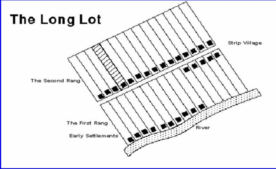
10 Villages grew up along the roads and because there were so few intersections, the villages tended to be linear in shape, that is, stretched along the road. Because the lots were so thin, farmhouses were close together and this was very important in the early years as people were very dependent upon each other for labour and companionship during the long dark winters. As French-Canadians moved to other parts of Canada, they took this settlement system with them. It can be seen in parts of southwestern Ontario near Windsor, southern Manitoba and the Peace River district of British Columbia.

11 Long Lots of Southern Quebec Developed along waterways Settled before survey system implemented Long, thin farms Heritage Law owners had to divide land amongst offspring

12

13 Advantages and Disadvantages Pros Excellent soil conditions Access to river ways Narrow lower taxes Close to neighbours Cons Narrow lots hard to work Land became small and unworkable when divided amongst offspring

14

15 Where is this? Montreal (note the long lot pattern)

16 Concession System in Ontario Occurred after survey system was in place Based on road and railways no longer dependent on water Concession Roads are parallel to waterway, and side roads are perpendicular

17 Concession system of Southern Ontario

18 Concessions are areas of land enclosed by the grid pattern of the survey system used in Southern Ontario. Most of these survey lines are now roads. Within concessions the land was divided into equal farm lots.

19
20 Parallel and close to the shoreline the baseline was survey. Then, spaced 1.25 miles (approximately 2km) apart, a series of parallel lines was surveyed. These later became concession roads. At the same time a series of lines was surveyed at right angles to the concessions. These became roads known as county lines. The resulting squares, about 2km by 2km are known as concessions, and portions of these were given to settlers to clear and farm. Lake

21 Resources: agriculture Transportation: started at the lake, but there were roads, later railway (access to water less important, each settlement needed access to a road. Government policy: survey system already in place Concession System: started survey at a Great Lake, called BASELINE, Concession parrallel to lake, sideroad perpendicular roads 2km apart, farms 40 to 80 ha in size. Concession blocks Townships Counties Farmhouses tended to be built near intersections so as to be close to one another and some of these collections of houses grew into villages, towns, etc. if they were on good transportation routes. (Towns also grew at mill sites on rivers or streams.) For administrative purposes, concessions were put together to form townships, and townships were put together to form counties.
22 Advantages and Disadvantages Pros Excellent soil for agriculture Access to roadways Easier access to land Cons Further from neighbours
23
24 Counties of Southern Ontario
25 Counties and townships of Southern Ontario
26 Why was there a different system in Ontario than Quebec? Because Ontario was settled later than Quebec and the technology to build roads was much improved. Note that the distance between the roads varied a little and that roads sometimes did not line up exactly. This system of survey and road building was supervised by Col. John Graves Simcoe.
27 Section system of the Prairies
28 Section System in Southern Land was surveyed before settlement occurred Land divided into 36 sections and each section divided into 4 quadrants A family would get one quadrant approx. 64ha in size Prairies
29
30 Advantages and Disadvantages Pros Land was well suited for modern farm machinery Cons Soil was less fertile - needed larger farms Resulted in farm consolidation Some distance between neighbours
 Township (9.6 x 9.")
31 INFLUENCES: Resources: agriculture Transportation: roads, later railway (access to water less important) Government policy: surveyed before major settlement occurred, used the section system. They did not want the U.S to have the land! BUT the lots were too small. Families needed large lots for a larger harvest. Started survey at the Canada/US border (49th latitude) Township (9.6 x 9.6 km OR 6 x 6 miles) 36 sections (1 mile x 1 mile) Quarter Sections (64 ha)
32 Western Canada was surveyed before there was any large scale settlement for three reasons: 1. The government was afraid that the U.S. might take over the Canadian west if there was no sign of occupation. 2. The population was growing in Ontario and there was a demand for more land. 3. The government wished to avoid the kind of land disputes that occurred in the U.S. when their west was settled (lawlessness, etc.).
33 The government needed a fast, efficient system to settle the west. The baseline was the 49th Parallel and survey lines were drawn on maps every 6 miles (10kms) parallel to the baseline. These were called township lines. North-south lines were surveyed and mapped every 6 miles to form long wide bands called ranges. The enclosed squares, called townships, are 36 miles square. These were subdivided into 36 one-square-mile blocks called sections. Each section was subdivided into quarter-sections.
34 These squares were subdivided into 36 sections, each 1 mile by 1 mile. survey lines were 6 miles apart Baseline - 49 th parallel
35 each section was 1 mile by 1 mile each section was sub-divided into 4 quarter-sections, which were given to settlers, or reserved for churches, schools, the railways, the Hudson Bay Company, etc
36 Some quarter sections were granted to settlers, some reserved for schools and churches, some for the railway, and some for the Hudson Bay Company, the previous owner. Each settler family was given a quarter section which they could keep if they built a house and cleared a certain amount of it within a given period of time. Many settlers came from Eastern Europe (even some from Iceland). The farms were larger than down east because the combination of soil and climate conditions means lower profits per hectare. Grain elevators were constructed at regular intervals along the rail lines (for farmers to bring their grain to) and villages and towns grew at these locations.
37
38 On average, grain elevators tended to be 13 miles apart along the railway lines.
39

40 Other rural scattered settlements INFLUENCES: 1 Resource - based settlement: ie. Atlantic and Pacific Maritime ecozones = fishing OR Montane Cordillera = mining/energy 2 Service - based Settlement: ie. along transportation routes, people work in hotels, gas stations or restaurants.
41 Isolated Settlements Isolated settlements tended to grow at the locations of natural resources and usually in areas where a survey had not taken place. This was a lot of Canada as extensive surveys in the early days were only done on the arable land of the country, which amounts to very little of the Canadian land mass. Examples of isolated settlements include fishing ports on coasts, mining and lumbering towns, hydroelectric sites, recreational spots, scientific and military communities, and transportation locations.
42 Issues with Rural Areas Today Movement towards urbanization Movement to commercial farming Technology is advancing farming practices Fewer services provided within rural regions Increased costs for goods and services Less rural areas as a result of urbanization
43 Readings Read text pg Define key terms Questions 1, 4, 5, 7ab, 8
DOMINION LAND SURVEY. COMPOSED AND PRODUCED BY : Chris Rule. Permission is granted for use by acknowledging the author s name.
 COMPOSED AND PRODUCED BY : Chris Rule Permission is granted for use by acknowledging the author s name. The Dominion Land Survey System was initiated by the Canadian Government in 1869 for settlement purposes.
GEOGRAPHIC INFORMATION SYSTEMS Lecture 11: Land Division Systems
 GEOGRAPHIC INFORMATION SYSTEMS Lecture 11: Land Division Systems Land Division Systems - in many applications of GIS, land ownership is an important data layer and it is important for GIS users to be familiar
Public Land Survey System - Definition
 Public Land Survey System - Definition The Public Land Survey System (PLSS) is a method used in the United States to locate and identify land, particularly for titles and deeds of farm or rural land. The
CHAPTER 4 LEGAL DESCRIPTION OF LAND DESCRIBING LAND METHODS OF DESCRIBING REAL ESTATE
 r CHAPTER 4 LEGAL DESCRIPTION OF LAND DESCRIBING LAND A legal description is a detailed way of describing a parcel of land for documents such as deeds and mortgages that will be accepted in a court of
Answer Keys to Unit Tests
 Reading Geography Series Answer Keys to Unit Tests Unit 1 The Five Themes of Geography Unit 2 Patterns in Physical Geography Unit 3 Natural Resources 7 Portage & Main Press Unit Test for The Five Themes
Answer Keys to Unit Tests
 Reading Geography Series Answer Keys to Unit Tests Unit 1 Patterns in Human Geography Unit 2 Economic Systems Unit 3 Migration 8 Portage & Main Press Unit Test for Patterns in Human Geography A. Understanding
FUR TRADE PHASE 1 The Early Fur Trade 1500-1603 A Glimpse of the Early Fur Trade
 FUR TRADE PHASE 1 The Early Fur Trade 1500-1603 The cod fishery began the early fur trade. First Nations such as the Mi kmaq began to trade with Europeans coming to fish cod off the east coast. The British
2015 Annual Alberta Labour Market Review. Employment. Unemployment. Economic Regions. Migration. Indigenous People. Industries
 2015 Annual Alberta Labour Market Review Employment. Unemployment. Economic Regions Migration. Indigenous People. Industries Occupations. Education. Demographics Employment Despite the economic downturn,
Otázka: Canada. Jazyk: Angličtina. Přidal(a): Tomdog3 BASIC FACTS. Capital. o Ottawa. Official languages. o English. o French. Area = 9.970.
: Tomdog3 BASIC FACTS. Capital. o Ottawa. Official languages. o English. o French. Area = 9.970.") Otázka: Canada Jazyk: Angličtina Přidal(a): Tomdog3 BASIC FACTS Capital o Ottawa Official languages o English o French Area = 9.970.610 km 2 Largem cities o Montreal, Calgary o Toronto, Vancouver Metropolitan
Otázka: Canada Jazyk: Angličtina Přidal(a): Tomdog3 BASIC FACTS Capital o Ottawa Official languages o English o French Area = 9.970.610 km 2 Largem cities o Montreal, Calgary o Toronto, Vancouver Metropolitan
About Fact Sheets Contact Us Partners Products Site Map FAQ Help
 About Fact Sheets Contact Us Partners Products Site Map FAQ Help Home Articles PLSS Article The Public Land Survey System (PLSS) What is the PLSS? History Commonly Used Terms Related Links What is the
The Number of Businesses in Alberta is Gaining Momentum
 ECONOMIC COMMENTARY The Number of Businesses in Alberta is Gaining Momentum Highlights: The number of businesses in Alberta reached record-levels in 2012, with over 154,000 now having at least one employee.
Rectangular survey System (Township and Rang System). Pg. 381. Designed to facilitate the movement of non-indians across the farmlands of the U.S.
. Pg. 381. Designed to facilitate the movement of non-indians across the farmlands of the U.S.") Rectangular survey System (Township and Rang System). Pg. 381. Designed to facilitate the movement of non-indians across the farmlands of the U.S. Does not take terrain into account. Metes and Bounds
Rectangular survey System (Township and Rang System). Pg. 381. Designed to facilitate the movement of non-indians across the farmlands of the U.S. Does not take terrain into account. Metes and Bounds
CULTURAL HISTORY The United States Public Land Survey System The Rectangular Grid By Neal McLain
 CULTURAL HISTORY The United States Public Land Survey System The Rectangular Grid By Neal McLain In last month's column, I discussed the origin of the United States Public Land Survey System (USPLSS, or
Survey of the Louisiana Purchase in 1815
 Lesson Strategy for the Louisiana Purchase Bicentennial Instructor Copy Survey of the Louisiana Purchase in 1815 Grades: 4-12 Suggested Time Frame: Two, 50-minute class periods Objectives: To understand
PERMANENT RESIDENTS 2014
 PERMANENT RESIDENTS 290,000 280,000 270,000 260,000 250,000 240,000 230,000 220,000 210,000 Permanent Residents in Canada 280,688 260,067 235,823 2004 2005 2006 2007 2008 2009 2010 2011 2012 2013 Economic
WHAT MAPS SHOW US Maps do 4 things:
 WHAT MAPS SHOW US Maps show us a range of features, for example: Landforms: Settlement: Communication: Land Use: Geology: Other Info: - hills - valleys - mountains - isolated dwellings - farms - villages
Grades 3-5. Benchmark A: Use map elements or coordinates to locate physical and human features of North America.
 Grades 3-5 Students use knowledge of geographic locations, patterns and processes to show the interrelationship between the physical environment and human activity, and to explain the interactions that
CANADIAN CITIZENSHIP STUDY QUESTIONS & ANSWERS for the City of Richmond, 2010
 CANADIAN CITIZENSHIP STUDY QUESTIONS & ANSWERS for the City of Richmond, 2010 Section 1: Questions about Canada Aboriginal Peoples 1. Who are the Aboriginal peoples in Canada? The Aboriginal peoples were
Burnt River Black River and Gull River Flood Contingency Plan
 Burnt River Black River and Gull River Flood Contingency Plan Objective: The objective of this plan is to preplan and prepare for flooding events in the Burnt River, Black River and Gull River area of
Canada: A Changing Society
 Reading History Series Sample Pages Canada: A Changing Society Archives of Ontario, F229-308, T. Eaton Co. fonds Unit 3 Jennette MacKenzie, Susan Green, and Mary Quennell Student Name: Table of Contents
A Green Sector Overview
 A Green Sector Overview Micro Hydro Electric Power Ontario's Waterpower Resources: Past and Present The first hydroelectric generator in Canada was installed near Ottawa, which was the first city in North
Stage 4. Geography. Blackline Masters. By Karen Devine
 1 Devine Educational Consultancy Services Stage 4 Geography Blackline Masters By Karen Devine Updated January 2010 2 This book is intended for the exclusive use in NSW Secondary Schools. It is meant to
INVEST IN PRINCE GEORGE REAL ESTATE OPPORTUNITIES COMMERCIAL PROPERTIES
 INVEST IN PRINCE GEORGE REAL ESTATE OPPORTUNITIES COMMERCIAL PROPERTIES REAL ESTATE INVESTMENT OPPORTUNITIES* 5 6 Downtown Prince George Properties 1. 6 th Avenue & Quebec Street 2. 2 nd Avenue & Victoria
Agricultural Production and Research in Heilongjiang Province, China. Jiang Enchen. Professor, Department of Agricultural Engineering, Northeast
 1 Agricultural Production and Research in Heilongjiang Province, China Jiang Enchen Professor, Department of Agricultural Engineering, Northeast Agricultural University, Harbin, China. Post code: 150030
CPCS Supply Chain Review. Eastern Canada Logistics Study By CPSC November 2012
 CPCS Supply Chain Review Eastern Canada Logistics Study By CPSC November 2012 Disclaimers 1. Study was initially presented in July 2013 in Montreal and may be repetitive for some of you. 2. Some of the
Understanding Land Measurement and Legal Descriptions
 Lesson A2 1 Understanding Land Measurement and Legal Descriptions Unit A. Mechanical Systems and Technology Problem Area 2. Soil and Environmental Technology Systems Lesson 1. Understanding Land Measurement
French-speaking Canada. First Nations
 Canada The capital is Ottawa It is a constitutional monarchy: the British monarch is the head of state. Very high living standards A multicultural society The second largest country in the world (after
Location for the Data Centre Industry Reliable traditional & renewable power Available cooling water Environmental & political stability
 Location for the Data Centre Industry Reliable traditional & renewable power Available cooling water Environmental & political stability July 2014 Location The City of Sarnia is located in the County of
CONTENTS ABSTRACT. KEYWORDS:. Forest ownership, forest conversion.
 CONTENTS INTRODUCTION... Page PHYSICAL CHANGES IN COMMERCIAL FOREST AREA... 4 Nearly 1 million acres have been lost since 1945... 4 Road construction was leading cause of forest loss in the two states...
Statistical Profile of Lunenburg County
 Statistical Profile of Lunenburg County Prepared by the Nova Scotia Federation of Agriculture 1 Contents 1.0 Introduction... 2 Agriculture in the Local Economy... 2 2.0 Population and Population Change...
Weekend Cabin Retreat Project Site Plans
 Weekend Cabin Retreat Project Site Plans Sacramento City College EDT 300/ENGR 306 EDT 300/ENGR 306 - Site Plans 1 Cabin Project Site Plan/Bubble Diagram - Assignment 1 =10-0 Floor Plan - Assignment 1/4
10.1 WILL HEY FARM WATFORD LANE NEW MILLS RETENSION OF NEW STABLE BLOCK, SAND PADDOCK AND ASSOCIATED EARTHWORKS AND LANDSCAPING (FULL - MINOR)
") HPK/2012/0207 03/04/2012 WILL HEY FARM WATFORD LANE NEW MILLS MR & MRS M WILSON KIRSTY WILSON EQUINE AND WILL HEY FARM BED & BREAKFAST RETENSION OF NEW STABLE BLOCK, SAND PADDOCK AND ASSOCIATED EARTHWORKS
HPK/2012/0207 03/04/2012 WILL HEY FARM WATFORD LANE NEW MILLS MR & MRS M WILSON KIRSTY WILSON EQUINE AND WILL HEY FARM BED & BREAKFAST RETENSION OF NEW STABLE BLOCK, SAND PADDOCK AND ASSOCIATED EARTHWORKS
BALBHARATI PUBLIC SCHOOL, PITAMPURA,NEW DELHI COMPREHENSIVE NOTES CHAPTER-6 HUMAN RESOURCES CLASS-VIII SUBJECT-GEOGRAPHY FINAL TERM
 BALBHARATI PUBLIC SCHOOL, PITAMPURA,NEW DELHI COMPREHENSIVE NOTES CHAPTER-6 HUMAN RESOURCES CLASS-VIII SUBJECT-GEOGRAPHY FINAL TERM Q1. Why are people considered as a resource? A1. People are a nation
Lesson 2: The Nature of Real Property. Real Property. Real Property. Real Estate Principles of Georgia. vs. Personal Property.
 Real Estate Principles of Georgia Lesson 2: The Nature of Real Property 1 of 53 23 Real Property vs. Personal Property Two types of property: Real property, ( realty ), real estate Personal property (
Tennessee Agricultural Production and Rural Infrastructure
 Tennessee Trends in Agricultural Production and Infrastructure Highlights - In many states the percentage of the state population designated by the U.S. Census Bureau as living in rural areas has declined,
SACRAMENTO COUNTY SUMMARY OF ZONING CLASSIFICATIONS
 SACRAMENTO COUNTY SUMMARY OF ZONING CLASSIFICATIONS This document provides a brief overview of zoning designations only. Inaccuracies may be present. Please consult the Sacramento County Zoning Code for
Halton Region Planning & Public Works Committee Meeting July 8, 2015
 Acton Quarry Extension Halton Region Planning & Public Works Committee Meeting July 8, 2015 1 Proposed Extraction Area 50% Reduction The extraction area was reduced by 50% to address comments from the
ELEMENTS OF SURVEYING FOR CADASTRAL MAPPING
 ELEMENTS OF SURVEYING FOR CADASTRAL MAPPING Chapter 4 2015 Cadastral Mapping Manual 4-0 Elements of Surveying and Mapping Utah's system of land surveying is the rectangular survey system as set forth on
Early retirement trends
 Patrick Kieran IN THE EARLY 197S, one in five Canadians was 5 or older. By 8, one in three will fall into this age group. This reality has led many researchers to focus on the potential consequences of
Tutorial on the Public Land Survey System Descriptions
 Tutorial on the Public Land Survey System Descriptions From the Wisconsin Department of Natural Resources (http://www.dnr.state.wi.us/org/land/forestry/private/plsstut/plsstut1.htm) When the land was first
ICE BARLEY FUTURES & OPTIONS. www.theice.com. April 2013. IntercontinentalExchange ICE Futures Canada ICE Clear Canada
 ICE BARLEY FUTURES & OPTIONS April 2013 IntercontinentalExchange ICE Futures Canada ICE Clear Canada www.theice.com Page 2 of 5 ICE Futures Canada is pleased to introduce new Barley futures and options
Women who are Moving Ohio into a Prosperous New World. Ohio s Maritime Vision
 Women who are Moving Ohio into a Prosperous New World Ohio s Maritime Vision Presented by: Rose Ann DeLeón Director of Government Relations and Federal Affairs Cleveland-Cuyahoga County Port Authority
Outline. The Atlantic Northeast and French Canada. Atlantic Northeast Defining the Region. Atlantic Northeast Defining the Region
 The and Outline 1. The 2. and Overarching Themes Defining the Region What s the unique characteristic? Less explicit than other unique characteristics Character, rurality, not French, relatively limited
CHAPTER 8 - LAND DESCRIPTIONS
 CHAPTER 8 - LAND DESCRIPTIONS Notes: While the location of land is commonly referred to by street number and city, it is necessary to use the legal description in the preparation of those instruments relating
The Role of Land Use and Transportation in Building Successful Sustainable Cities City of Vancouver
 The Role of Land Use and Transportation in Building Successful Sustainable Cities City of Vancouver Dr. Ann McAfee Co-Director of Planning, Vancouver Transportation & Land Use 1. Vancouver s Transportation
SECTION 2 CORRIDOR A
 SECTION 2 CORRIDOR A 2.1 CORRIDOR A (HILLSBOROUGH RIVER TO 40 TH STREET IN TAMPA) The boundaries for Corridor A can be seen in Figure 2-1. They are as follows: North: I-4 South: Crosstown Expressway (now
GHANA. www.dlapiper.com 01
 GHANA www.dlapiper.com 01 Introducing Reindorf Chambers and the Ghanaian legal environment Key information on Ghana Formerly known as the Gold Coast, Ghana is located in West Africa, and became independent
USE SOURCE A (THE WHITE MOUNTAIN MAP) TO ANSWER THE FOLLOWING QUESTIONS (1-4).
 TO ANSWER THE FOLLOWING QUESTIONS (1-4).") HOËRSKOOL MONTANA GRADE 8 SOCIAL SCIENCE EXAMINERS: DATE: JUNE 2012 Mr E.P. KLEYNHANS TIME: 1 HOUR Mr. L. TAUTE TOTAL: 100 ANSWER ALL THE QUESTIONS ON THE FOLIOP PAPER. NO WORK ON THE EXAM PAPER WILL BE
HOËRSKOOL MONTANA GRADE 8 SOCIAL SCIENCE EXAMINERS: DATE: JUNE 2012 Mr E.P. KLEYNHANS TIME: 1 HOUR Mr. L. TAUTE TOTAL: 100 ANSWER ALL THE QUESTIONS ON THE FOLIOP PAPER. NO WORK ON THE EXAM PAPER WILL BE
MEADOWVALE VILLAGE HCD PLAN REVIEW BACKGROUND STUDY
 MEADOWVALE VILLAGE HCD PLAN REVIEW BACKGROUND STUDY OCTOBER 4, 2012 INTRODUCTION Resident concerns spark formation of ratepayers group in late 1960s OHA 1974 provides mechanism for a municipality to protect
THE APPRAISAL OF REAL ESTATE 3 RD CANADIAN EDITION BUSI 330
 THE APPRAISAL OF REAL ESTATE 3 RD CANADIAN EDITION BUSI 330 REVIEW NOTES by CHUCK DUNN CHAPTER 10 Copyright 2010 by the Real Estate Division and Chuck Dunn. All rights reserved ARE 3 rd EDITION REVIEW
Chapter 8, Section 2 The Louisiana Purchase. Pages 272-277
 Chapter 8, Section 2 The Louisiana Purchase Pages 272-277 American Settlers Move West By the early 1800s, thousands of Americans settle in the area between the Appalachians and the Mississippi River. Kentucky,
CANNES 2013 12/15 MARCH 2013 GDYNIA S OFFER PRZEMYSKA BALTIC PORT OF NEW TECHNOLOGIES GDYNIA WASZYNGTONA LOGISTICS CENTRE PORT OF GDYNIA
 CANNES 2013 12/15 MARCH 2013 GDYNIA S OFFER PRZEMYSKA BALTIC PORT OF NEW TECHNOLOGIES GDYNIA WASZYNGTONA LOGISTICS CENTRE PORT OF GDYNIA POMERANIAN LOGISTICS CENTRE TCZEW S OLD TOWN PLOT CASTLE HILL IN
12.5: Generating Current Electricity pg. 518
 12.5: Generating Current Electricity pg. 518 Key Concepts: 1. Electrical energy is produced by energy transformations. 2. Electrical energy is produced from renewable and non-renewable resources. 4. Electrical
VISUAL 6.1 GREAT BRITAIN S AMERICAN COLONIES
 SPECIALIZATION AND TRADE IN THE THIRTEEN COLONIES LESSON 6 VISUAL 6.1 GREAT BRITAIN S AMERICAN COLONIES GREAT BRITAIN S COLONIES All colonies are rich in natural resources but short on labor. PRODUCTIVE
Cambridge International Examinations Cambridge International General Certificate of Secondary Education
 Cambridge International Examinations Cambridge International General Certificate of Secondary Education *0123456789* GEOGRAPHY 0460/02 Paper 2 Geographical skills For Examination from 2016 SPECIMEN PAPER
Renewable Energy from Biomass. Opportunities in London and Area? Eric Rosen
 Renewable Energy from Biomass Opportunities in London and Area? Eric Rosen KMW ENERGY INC. LONDON, ONTARIO Tel: (519) 686-1771 www.kmwenergy.com Company Background Long History in designing bioenergy systems.
British Columbia s Clean Energy Vision
 British Columbia s Clean Energy Vision Innovative Technologies and Green Energy Solutions National Environmental Conference Brunei Darussalam July 1, 2010 Profile of British Columbia Overview British
SPECIFIC CLAIMS TRIBUNAL SKUPPPAH INDIAN BAND
 SCT File No.: SCT- SPECIFIC CLAIMS TRIBUNAL BETWEEN: SKUPPPAH INDIAN BAND Claimant V. HER MAJESTY THE QUEEN IN THE RIGHT OF CANADA as represented by the Minister of Indian Affairs and Northern Development
Phases 2 & 3, & Addendum Urban Structure Plan Options for West Whitby
 7. 5 A d v a n t a g e s a n d D i s a d v a n t a g e s Table 22 summarizes the advantages and disadvantages of each option based on the evaluation of Table 16. Dillon Consulting Limited Page 75 Table
SOCIAL STUDIES UNIT OUTLINES FOURTH GRADE
 SOCIAL STUDIES UNIT OUTLINES FOURTH GRADE In fourth grade, students use their understanding of social studies concepts and skills to explore Washington State in the past and present. Students learn about
APPENDIX E CULTURAL RESOURCE MANAGEMENT REPORT (CRM, 2013) Environmental Assessment Registration Document for Irish Cove Quarry Expansion
 Environmental Assessment Registration Document for Irish Cove Quarry Expansion") APPENDIX E CULTURAL RESOURCE MANAGEMENT REPORT (CRM, 2013) Environmental Assessment Registration Document for Irish Cove Quarry Expansion DEXTER CONSTRUCTION COMPANY LIMITED IRISH COVE QUARRY EXPANSION
APPENDIX E CULTURAL RESOURCE MANAGEMENT REPORT (CRM, 2013) Environmental Assessment Registration Document for Irish Cove Quarry Expansion DEXTER CONSTRUCTION COMPANY LIMITED IRISH COVE QUARRY EXPANSION
Marine Protected Areas POLICY
 Marine Protected Areas POLICY Canada March 1999 Published by: Canada Marine Ecosystems Conservation Branch Oceans Directorate Ottawa, ON K1A 0E6 DFO / 5870 Minister of Public Works and Government Service
Indiana Survey Townships
 Page 46 IN-GENious! The Rectangular Survey System in Indiana and Using the GIS Atlas by Annette Harper You ve found a wonderful deed or land patent and now you d like to pinpoint exactly where your ancestor
Survey Data Analysis with China and US Geo-Explorers. Shuming Bao China Data Center University of Michigan
 Survey Data Analysis with China and US Geo-Explorers Shuming Bao China Data Center University of Michigan Topics 1. Exploring local amenity data (environmental data) with China Geo-Explorer 2. Integrating
International Boundary Study. China Hong Kong Boundary
 International Boundary Study No. 13 April 13, 1962 China Hong Kong Boundary (Country Codes: CH-HK) The Geographer Office of the Geographer Bureau of Intelligence and Research INTERNATIONAL BOUNDARY STUDY
FORMULA FOR FINDING THE SQUARE FEET OF A RECTANGLE L x W = A
 UNIT I REAL ESTATE MATH AREA MEASUREMENTS FORMULA FOR FINDING THE SQUARE FEET OF A RECTANGLE L x W = A Where: A = Area L = Length W = Width If the length = 30 and the width = 20 20 x 30 = 600 Sq. Feet
Alternatives and Design Evolution: Planning Application 1 - RBKC
 3 Alternatives and Design Evolution: Planning Application 1 - RBKC Design Freeze Draft One (January 2011) Figure 3-19 3.82 The design freeze draft one was a point in time in the evolution of the Masterplan
Frequently Asked Transmission Pipeline Questions
 Frequently Asked Transmission Pipeline Questions Who is PennEast, LLC? PennEast was formed by the partnership of AGL Resources, NJR Pipeline Company, South Jersey Industries and UGI Energy Services (UGIES).
Geography affects climate.
 KEY CONCEPT Climate is a long-term weather pattern. BEFORE, you learned The Sun s energy heats Earth s surface unevenly The atmosphere s temperature changes with altitude Oceans affect wind flow NOW, you
Høyanger Upper Secondary School
 Høyanger Upper Secondary School The Upper Secondary School is situated in the western part of Norway, along the Sognefjord, a 3 hours drive from Bergen, the second largest town in Norway. Our school has
Profile of Canadian Environmental Employment
 Profile of Canadian Environmental Employment LABOUR MARKET RESEARCH STUDY 2010 ECO CANADA ECO Canada develops programs that help individuals build meaningful environmental careers, provides employers with
As you begin to search for a U.S. college or university, you should think about:
 Define Your Priorities When searching for an undergraduate program in the United States, it is important to first decide what is most important to you. This will help guide you through each of Your 5 Steps
Municipality of the District of West Hants
 Municipality of the District of West Hants STAFF REPORT TO: FROM: West Hants Planning Advisory Committee Jeanne Bourque, Planner DATE: July 21, 2011 SUBJECT: Richard Pineo - Application to Amend the West
Using Aerial Photography to Measure Habitat Changes. Method
 Then and Now Using Aerial Photography to Measure Habitat Changes Method Subject Areas: environmental education, science, social studies Conceptual Framework Topic References: HIIIB, HIIIB1, HIIIB2, HIIIB3,
Searching Land Records thru the BLM General Land Office Records.
 Searching Land Records thru the BLM General Land Office Records. Land Records can be an exciting addition to your family history search. The United States Government transferred ownership of land to millions
No. 7 Early Settlers
 No. 7 Early Settlers Many different groups of people have settled in Nebraska. The very first were Indians who came here more than 10,000 years ago. They were nomadic hunters who were looking for an area
Centre for Sustainable Organisations and Work & Gippsland Trades and Labour Council Inc. People and the Economy Report No.1
 Centre for Sustainable Organisations and Work & Gippsland Trades and Labour Council Inc Labour Market Profile: Latrobe Valley Region, Gippsland, Victoria People and the Economy Report No.1 2015 www.rmit.edu.au/research/csow
Water Quality and Water Usage Surveys
 Appendix 1 Water Quality and Water Usage Surveys This appendix contains copies of the Water Quality Survey and the Lake Usage Survey that we used to complete the watershedbased community assessments. We
Chapter 5. Transportation. Decatur County Comprehensive Plan. Introduction. Goals and Objectives. Goal. Objectives. Goal.
 Chapter 5 Transportation Chapter 5: Transportation Introduction The transportation system forms the backbone of a community. I-74 connects Decatur County with the large metropolitan areas of Cincinnati
Farmland Values Report
 Farmland Values Report This report covers the period from January 1 to December 31,. For more information: 1-888-332-3301 or [email protected] This report was published on April 14, 2014. Farmland
Competitive Analysis Economic Vision for the City of Burlington
 Competitive Analysis Economic Vision for the City of Burlington Burlington Economic Development Corporation DRAFT 1 Millier Dickinson Blais ACKNOWLEDGEMENT This report has been supported by the Ministry
CLIMATE, WATER & LIVING PATTERNS THINGS
 CLIMATE, WATER & LIVING PATTERNS NAME THE SIX MAJOR CLIMATE REGIONS DESCRIBE EACH CLIMATE REGION TELL THE FIVE FACTORS THAT AFFECT CLIMATE EXPLAIN HOW THOSE FACTORS AFFECT CLIMATE DESCRIBE HOW CLIMATES
PEI Population Demographics and Labour Force Statistics
 PEI Population Demographics and Labour Force Statistics PEI Public Service Commission PEI Population Demographics and Labour Force Statistics Diversity Division PEI Public Service Commission November 2010.
Avison Management Services Ltd. COMPANY PROFILE
 Avison Management Services Ltd. COMPANY PROFILE Providing resource management through environmental leadership. Mission Statement: We are committed to providing high quality, timely, and cost effective
Eurobodalla. Area Profile. Key Industry: Tourism & accommodation, Retail, Health & Community Services, Education
 Eurobodalla Area Profile Population: 37,714 persons (2010 est. resident population) Growth Rate: 3.1% (2006-2010) 0.8% ave. annual growth Key Industry: Tourism & accommodation, Retail, Health & Community
Farming. In the Standard Grade Geography exam there are three types of farming you need to know about arable, livestock and mixed.
 Types of Farming In the Standard Grade Geography exam there are three types of farming you need to know about arable, livestock and mixed. Arable farms are ones where the main way of making money is by
The NSS - Rural Development and Rural Settlement
 The NSS - Rural Development and Rural Settlement Spatial Planning Unit, Department of the Environment and Local Government, February 2003 Introduction. This paper has three main parts that outline: (1)
The Electrical Manufacturing Industry
 The Electrical Manufacturing Industry By Fred Kee Many Canadian manufacturers have played key roles in the development of electric power from the early days and have made significant contributions to the
Philadelphia County. Land Use and Growth Management Profile
 Philadelphia County is located in the southeastern corner of Pennsylvania and is bordered by the Pennsylvania counties of Delaware, Montgomery, and Bucks, and the New Jersey counties of Burlington, Camden,
ENVIRONMENTAL REVIEW SCREENING QUESTIONS
 ENVIRONMENTAL REVIEW SCREENING QUESTIONS All applications to WHEDA are required to meet the Department of Housing and Urban Development s environmental compliance standards listed in 24 CFR Part 58. Your