Atlantic County, New Jersey Flood Hazard Mapping Status Report
|
|
|
- Gabriel Flowers
- 8 years ago
- Views:
Transcription
1 Atlantic County, New Jersey Flood Hazard Mapping Status Report T his fact sheet provides background information on the National Flood Insurance Program (NFIP) administered by the Federal Emergency Management Agency (FEMA) as well as an overview of the flood hazard mapping process being completed for Atlantic County, New Jersey. The Flood Insurance Rate Maps (FIRMs) for Atlantic County, New Jersey are being revised to reflect new data so residents, homeowners, business owners, and community officials can better understand their flood risk and manage development. BACKGROUND What Is The NFIP? In 1968, Congress established the NFIP in response to escalating costs to taxpayers for flood disaster relief. The NFIP is based on the agreement that if a community practices sound floodplain management, the Federal Government will make flood insurance available. FEMA maps flood hazard areas, including the Special Flood Hazard Area (SFHA), which is the area that has a 1% or greater chance of flooding in any given year. Development may take place within the SFHA provided that it complies with local floodplain management ordinances that meet the minimum Federal criteria. What Is A FIRM? When FEMA maps flood hazards in a community and/or county, two products are typically produced: a Flood Insurance Study (FIS) report and a Flood Insurance Rate Map (FIRM). A FIRM illustrates the extent of flood hazards in a community by depicting flood risk zones and the SFHA, and is used with the FIS report to determine who must buy flood insurance and the floodplain development regulations that apply in each flood risk zone. FIRMs also depict other information including Base Flood Elevations (BFEs) and/or depths associated with the risk zones and floodways, and common physical features such as roads. What Is The Significance Of The SFHA? The SFHA has at least a 1% chance of flooding in any given year, and at least a 26% chance of flooding over the life of a typical 30-year mortgage. The Flood Disaster Protection Act of 1973 mandates that flood insurance must be purchased for structures located within the SFHA as a condition of receipt of Federal or federally backed financing. ATLANTIC COUNTY FIS AND FIRM REVISION The May 30, 2014 preliminary FIRM: Incorporates revised flood hazard analysis for the 31 miles of coastal shoreline of Atlantic, New Jersey Redelineates and maps 97 miles of detailed riverine analysis and approximate analysis streams Updates the base map to 2012 orthophotography Incorporates digital topographic data Incorporates validated Letters of Map Change (LOMCs). May 2014

2 Atlantic County, New Jersey Flood Hazard Mapping Status Report FLOOD INSURANCE RATE MAP The May 30, 2014, preliminary FIRM for Atlantic County, New Jersey, incorporates a base map (2012 High Resolution Orthophotography) supplemented with stream centerlines and political and road name data. The key components of a FIRM are shown in the figure below. + + = Base Map Topography Flood Data Digital FIRM RESTUDIES and REDELINEATION Revised flood hazard analysis and mapping were incorporated for 31 coastal miles in Atlantic County, New Jersey. Redelineation was also performed for approximately 97 stream miles. Redelineation uses digital elevation data and effective flood elevations to revise the 1% and 0.2% annual chance flood hazard areas without conducting new hydrologic or hydraulic analyses. For more information on the studied streams, please see the accompanying insert Atlantic County, New Jersey, Floodplain Mapping Fact Sheet. VERTICAL DATUM CHANGE What Is A Vertical Datum? A vertical datum is a set of constants that defines a system for comparison of elevations. In the NFIP, a vertical datum is important because all elevations Sample Datum Conversion need to be referenced to the same system. Otherwise, surveys using different datums would have different elevations for the same point. Historically, the FIRMs have referenced the National Geodetic Vertical Datum of 1929 (NGVD 29). Now, a more accurate vertical datum is used the North American Vertical Datum of 1988 (NAVD 88). Why Is The Vertical Datum Changing? A datum needs to be updated periodically because geologic changes to the surface of the earth occur due to subsidence and uplift or changes in sea level. In addition, NGVD 29 was flawed because of erroneous assumptions that mean sea level at different tidal stations represented the same elevation (zero). We can now more accurately measure these elevation differences with an expanded geodetic network. Who Will Be Impacted By The Vertical Datum Change? Elevations in NAVD 88 should be used for floodplain management and flood insurance purposes. This change should be noted by anyone who uses the FIRM, particularly when comparing elevation data on the new FIRM with data from an old FIRM that was produced in NGVD 29. How Are NGVD 29 Flood Elevations Converted To NAVD 88? The difference between the two datums varies from location to location. Therefore, an average offset (the difference between NAVD 88 and NGVD 29) has been computed for Atlantic County. To convert from NGVD 29 to NAVD 88 in Atlantic County, New Jersey, use the following equation: NAVD 88 = NGVD feet For more information on the vertical datum change, see FEMA s publication Converting the National Flood Insurance Program to the North American Vertical Datum of 1988 Guidelines for Community Officials, Engineers, and Surveyors.

3 Atlantic County, New Jersey Flood Hazard Mapping Status Report FLOOD HAZARD MAPPING PROCESS The flood hazard mapping process is divided into three major phases, each offering opportunities for community involvement: Mapping Needs Assessment/Scoping Production Post-Preliminary Processing Post-Preliminary Processing We are now entering the post-preliminary phase. FEMA will hold a Consultation Coordination Officer s (CCO) meeting to present the May 30, 2014, preliminary FIRM to the community. Following the meeting, Atlantic County, New Jersey will be provided a 30-day comment period. A 90-day appeal period will also be initiated through publication of two notices in a local newspaper. After any concerns with the new maps are resolved, FEMA will issue a final determination. A final FIRM and FIS report will be published approximately six months after the final determination in both hardcopy (paper) and digital format. What are Appeals and Comments? When a FIRM revision results in new, proposed BFEs and/or flood depths, the proposed addition or modification of any SFHA boundary or zone designation, or the proposed addition or modification of any regulatory floodway, community officials, or individual property owners working through community officials, may submit a formal objection to FEMA during the 90-day appeal period. These objections, which are referred to as appeals, must be supported by scientific and technical data. Objections to any proposed base map feature changes are called comments; these generally involve concerns with corporate limits, jurisdictional boundaries, and/or road names. PROPERTY SPECIFIC REVIEWS How Do I Find Out if My Structure or Property Is Located in the Floodplain? You can view the current effective maps online by visiting the FEMA Map Service Center at You can also view paper copies of the FIRMs at your local map repository, locations of which are provided in the enclosed Floodplain Mapping Fact Sheet. For additional assistance with locating NFIP mapping products, you can contact the FEMA Map Information exchange (FMIX) toll-free at 1-877) FEMA MAP ( ) or you may the FMIX staff at FEMAMapSpecialist@riskmapcds.com. View the Preliminary FIRMs and FIS Online To view the preliminary FIRMs and FIS online, please visit You can also view paper copies of the preliminary maps at your local map repository listed below. Additional resources about the preliminary FIRMs and FIS, including the What is My BFE? address lookup tool, which allows users to compare the effective and the preliminary flood zone and BFE for their property are available on the following website: What Are The Options To Improve the Precision Of The New Map? Although FEMA uses the most accurate flood hazard information available, limitation of scale or topographic definition of the source maps used to prepare flood hazard maps may cause small areas that are at or above the BFE to be inadvertently shown within SFHA boundaries. Such situations may exist in Atlantic County. For these situations, FEMA established the Letter of Map Amendment (LOMA) and the Letter of Map Revision-based on Fill (LOMR-F) processes to remove such structures from the SFHA. LETTER OF MAP CHANGE REVALIDATION When a new FIRM becomes effective, it automatically supersedes previously issued LOMCs (LOMAs, LOMR-Fs, and Letters of Map Revision) that have been issued for property(ies) on the revised FIRM panels. Recognizing that some LOMCs may still be valid, FEMA has an automatic process for reviewing and revalidating LOMCs, as appropriate.

4 Atlantic County, New Jersey Flood Hazard Mapping Status Report FLOOD INSURANCE Who Should Purchase Flood Insurance? Standard homeowners insurance policies do not provide coverage against flood losses. Structures located in the SFHA that are financed by a federally-backed loan, are required to purchase flood insurance. However, FEMA recommends that all property owners Flood Insurance versus Disaster Assistance You are in control. Flood insurance claims are paid even if a flood is not a Presidentially declared disaster. Federal disaster assistance declarations are awarded in less than 50% of damaging floods. in at-risk areas carry flood insurance voluntarily. In addition, the National Flood Insurance Reform Act of 1994 requires individuals in SFHAs who receive disaster assistance for flood disaster losses to real or personal property to purchase and maintain flood insurance coverage for as long as they live in the dwelling. If flood insurance is not purchased and maintained, future disaster assistance will be denied. It is prudent to protect your investment with flood insurance even in low-to-moderate risk areas. Floods occur, with all too tragic frequency in these areas as well; in fact, nearly 25% of all NFIP claims are for properties outside of the SFHA. Structures in these areas are eligible for considerably lower cost coverage. Who May Purchase A Flood Insurance Policy? Insurance through the NFIP is available to all owners and renters (including condominium associations and condominium owners) of insurable property in a community participating in the NFIP. Insurable property includes buildings and/or the contents, including personal property. What Factors Determine Federal Flood Insurance Premiums? A number of factors are considered when determining your flood insurance premium. These factors include: the amount and type of coverage being purchased, location and flood zone, and the design and age of your structure. For homes in high-risk areas (e.g., Special Flood Hazard Areas or AE, VE Zones) built after the first Flood Insurance Rate Maps were prepared for that community, the elevation of the building in relation to the base flood elevation is also required. For more information, visit Flooding and Flood Risks or download Flood Insurance Basics to learn more. HOW HIGH WILL THE WATER GET THIS YEAR? How Is Flood Insurance Purchased? The steps to purchase flood insurance are: 1) A lender extending or renewing a loan informs an owner that the building is in a SFHA and flood insurance is required; or a property owner or renter perceives a risk of flooding and elects to purchase flood insurance. 2) The property owner or renter contacts a licensed insurance agent or broker. 3) The insurance agent completes the necessary forms. In the case of a building constructed in a SFHA after the issuance of a FIRM, a certified elevation certificate must be obtained from a surveyor, engineer, or architect. 4) The insurance agent submits the application and premium. WHERE CAN I GET MORE INFORMATION? For any questions concerning the Atlantic County, New Jersey, flood hazard mapping, or LOMAs and LOMR-Fs, please contact the FEMA Map Information exchange (FMIX) toll-free information line at (877) FEMA MAP ( ). For more information regarding the coastal analysis and mapping visit For more information about LOMAs and LOMR-Fs visit For any questions concerning flood insurance, please contact the Flood Insurance Program at (800) or visit

5 SCOPE OF STUDY
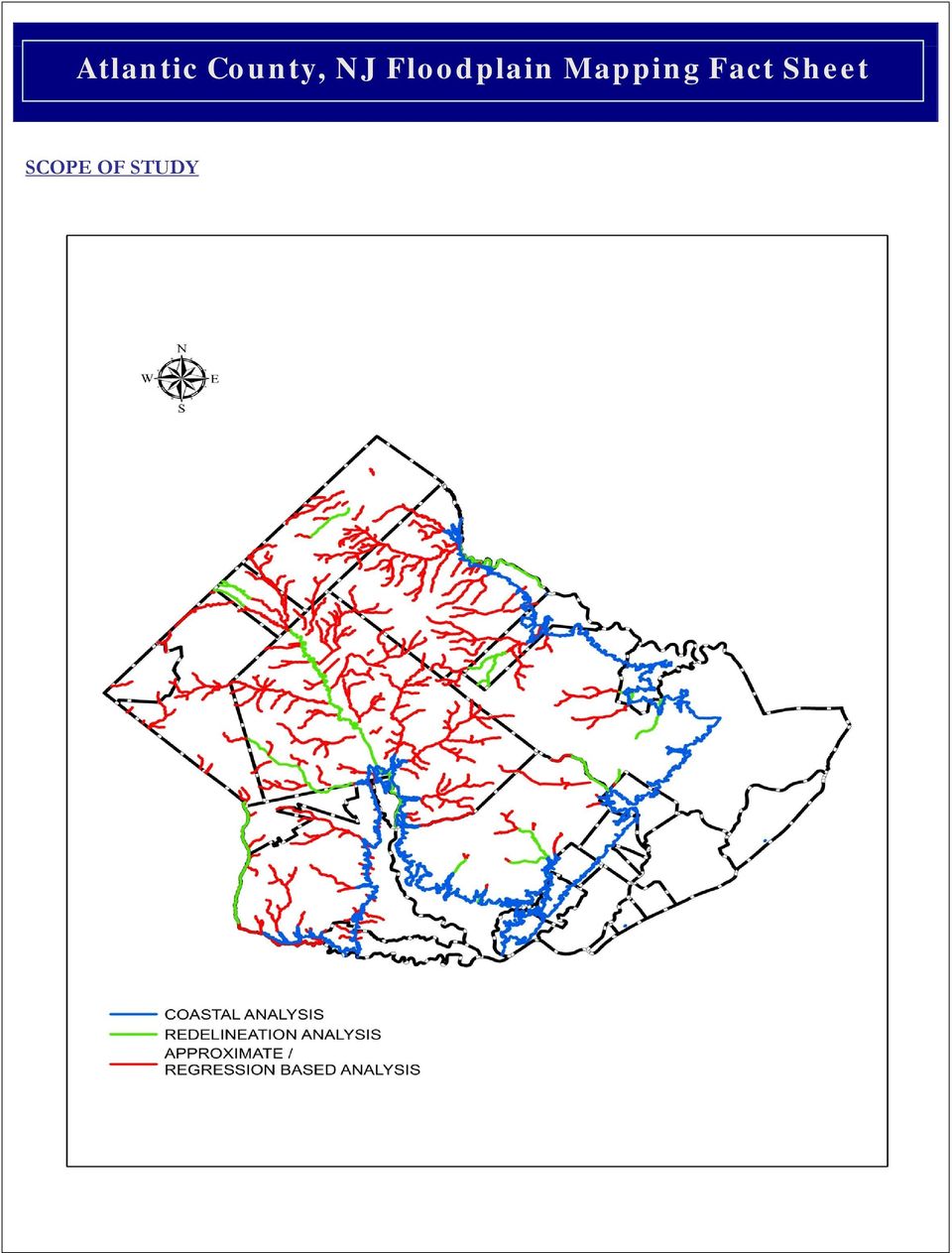
6 What was restudied? Stream Study Type Mileage Scope of Revision Coast Shoreline Coastal Analysis 31 Coast line of Atlantic County Which streams were redelineated? Stream Community Study Type Mileage Scope of Revision Babcock Creek Cedar Brook Clarks Mill Stream Cordery Creek Hamilton Town of Hammonton City of Port Republic From confluence with Great River Reach 1to approximately 1.43 miles upstream of confluence From Wharton Forest Boundary to Liberty Street From Mill Street to approximately 0.23 miles upstream of Indian Cabin Road From confluence of Reeds Bay to approximately 0.39 miles upstream of Brook Lane Doughty Creek English Creek Gravelly Run Hamilton From confluence with Reeds Bay to approximately 0.14 miles upstream of US Route 9 From confluence with Great Bay to approximately 0.78 miles upstream of School Road From confluence with Great River Reach 1 to approximately 0.05 miles upstream of New Jersey Route 559 Great Egg Harbor River Reach 1 Great Egg Harbor River Reach 2 Great Egg Harbor River Reach 2 Tributary Hospitality Branch City of Estell Manor, Hamilton, Weymouth Borough of Folsom Borough of Folsom Borough of Folsom, Buena Vista From approximately 3.75 miles downstream of Cape May Avenue to approximately 8.15 miles upstream of Weymouth Road From centerline of State Route 54 to the county boundary From confluence with Great Reach 2 River to county boundary From centerline of Railroad to approximately 0.18 miles upstream of Cains Mill Road

7 Stream Community Study Type Mileage Scope of Revision Lakes Creek Landing Creek Reach 2 Little Meadow Run Maple Run Mattix Run Mill Branch Morses Mill Stream Mullica River North Branch Patcong Creek South River Reach 2 Tributary to Atlantic City Reservoir City of Egg Harbor City City of Northfield, City of Port Republic Mullica, City of Linwood, City of Northfield, Hamilton, Weymouth From confluence with Great Bay to approximately 0.94 miles upstream of Bevis Mill Road From approximately 0.57 miles downstream of Philadelphia Avenue to approximately 20 feet upstream of Hamburg Avenue From confluence with Mill Branch to approximately 50 upstream of Ridge Road From confluence with Patcong Creek and Mill Branch to approximately 0.34 miles upstream of Mill Road From confluence with Nacote Creek to approximately 0.65 miles upstream of Pitney Road From confluence with Patcong Creek and Mill Branch to approximately 0.61 miles upstream of Ridge Road From the confluence with Clarks Mill Stream to just upstream of Moss Mill Road From the confluence with Great Bay to State Route 542 From confluence with Absecon Bay to railroad From confluence with Great Bay to confluence of Mill Branch and Maple Run From Forty Wire Road to approximately 0.76 miles upstream of Landis Avenue From confluence with North Branch to approximately 0.30 miles upstream of Eight Avenue

8 Stream Community Study Type Mileage Scope of Revision Tuckahoe River Reach 2 Union Creek Union Creek Tributary City of Estell Manor, Buena Vista, Weymouth City of Egg Harbor City City of Egg Harbor City From State Route 49 to approximately 2.13 miles upstream of Thirteenth Avenue From confluence with Landing Creek to Bremen Avenue From confluence with Union Creek to Atlantic Avenue How can I find more information regarding the revised mapping in Atlantic County? You can view the new map for your community by visiting your local map repository. The table below includes the location of the local floodplain administrator who may be able to help you locate your property on the new preliminary maps. Atlantic County, New Jeresey maps are available for reference and use on-site at the map repository, but not for distribution. Copies of the preliminary FIS and FIRMs are also available for review online at Community Name Floodplain Administrator Phone Number Map Repository City of Absecon Mike O Hagan Mill Road Absecon, NJ City of Atlantic City Wally Shields Bacharach Boulevard Atlantic City, NJ City of Brigantine Edward P. Stinson West Brigantine Avenue Brigantine, NJ Borough of Buena The Honorable Joseph Baruffi Buena Borough Construction and Permits Office 616 Central Avenue Minotola, NJ Buena Vista Township Hall Buena Debra Bell Harding Highway Vista Buena, NJ City of Corbin City Wayne Caregnato Route 50 Egg Harbor The Honorable James McCullough Corbin City, NJ Municipal Building 3515 Bargaintown Road Township, NJ 08234

9 Community Name Floodplain Administrator Phone Number Map Repository City of The Honorable Lisa Jiampetti London Avenue City City, NJ City of Estell Manor Wayne Caregnato x. 148 Cumberland Avenue 306 Estell Manor, NJ Borough Hall Borough of Folsom Pat Newton th Street Hamilton Town of Hammonton Richard Roesch Phil Sartorio x x490 Frank Domenico Folsom, NJ Construction Office 300 East Jimmie Leeds Road, NJ Hamilton Township Zoning Office 6101 Thirteenth Street Mays Landing, NJ Engineer s Office 850 South White Horse Pike Hammonton, NJ Construction Office City of Linwood Charles Kisby Poplar Avenue Linwood, NJ Borough Hall Borough of Longport Bruce Funk Atlantic Avenue Longport, NJ Construction Office City of Margate City Jim Galantino Winchester Avenue Margate City, NJ Mullica Thomas Sandman Mullica Township Hall 4528 White Horse Pike Elwood, NJ City of Northfield The Honorable Jerry McGee City of Pleasantville Kevin Cain Shore Road Northfield, NJ North 1st Street Pleasantville, NJ City of Port Republic John Kelly Main Street Port Republic, NJ Construction Office City of Somers Point Wes Swain Shore Road Somers Point, NJ City of Ventnor City Charles Sabatini Ventnor City Clerk s Office 6201 Atlantic Avenue Ventnor, NJ 08406

10 Community Name Floodplain Administrator Phone Number Map Repository Municipal Building Charles Fralinger South Jersey Avenue Weymouth Dorothy, NJ 08317

Passaic County, New Jersey Flood Hazard Mapping Status Report
 Passaic County, New Jersey Flood Hazard Mapping Status Report This fact sheet provides background information on the National Flood Insurance Program (NFIP) administered by the Federal Emergency Management
Ulster County, New York Flood Hazard Mapping Status Report for Property Owners
 Ulster County, New York Flood Hazard Mapping Status Report for Property Owners Ulster County, New York Flood Hazard Mapping Status Report for Property Owners FLOOD INSURANCE Who Should Purchase Flood Insurance?
Salem County, New Jersey Flood Hazard Mapping Status Report for Property Owners
 Salem County, New Jersey Flood Hazard Mapping Status Report for Property Owners Salem County, New Jersey Flood Hazard Mapping Status Report for Property Owners FLOOD INSURANCE Who Should Purchase Flood
Mercer County, New Jersey Flood Hazard Mapping Status Report for Property Owners
 Mercer County, New Jersey Flood Hazard Mapping Status Report for Property Owners Mercer County, New Jersey Flood Hazard Mapping Status Report for Property Owners FLOOD INSURANCE Who Should Purchase Flood
Mercer County, New Jersey Flood Hazard Mapping Status Report for Property Owners
 Mercer County, New Jersey Flood Hazard Mapping Status Report for Property Owners Mercer County, New Jersey Flood Hazard Mapping Status Report for Property Owners FLOOD INSURANCE Who Should Purchase Flood
Albany County, New York Flood Hazard Mapping Status Report for Property Owners
 Albany County, New York Flood Hazard Mapping Status Report for Property Owners Albany County, New York Flood Hazard Mapping Status Report for Property Owners FLOOD INSURANCE Who Should Purchase Flood Insurance?
Criteria for Appeals of Flood Insurance Rate Maps
 Criteria for Appeals of Flood Insurance Rate Maps November 30, 2011 This document outlines the criteria for appealing proposed changes in flood hazard information on Flood Insurance Rate Maps (FIRMs)
FEMA s FLOOD INSURANCE RATE MAPS
 My Lender is requiring me to purchase Flood Insurance Options for San Diego County Residents in Unincorporated Areas This document is intended to help San Diego County residents who have been contacted
James City County and Williamsburg Open House Meeting
 James City County and Williamsburg Open House Meeting What the New Preliminary Flood Insurance Rate Maps (FIRMs) Mean for Your Community and for You as a Property Owner August 13, 2014 1 Today s Open House
Essex County, NJ. Preliminary Flood Insurance Study & Flood Insurance Rate Maps Release. FEMA Region 2 May 29, 2014
 Essex County, NJ Preliminary Flood Insurance Study & Flood Insurance Rate Maps Release FEMA Region 2 May 29, 2014 Agenda Introduction Review: Preliminary Work Maps (July 2013) Preliminary Flood Insurance
1. Why is Lee County getting new flood hazard maps? 3. What are the benefits of the new flood hazard maps?
 1. Why is Lee County getting new flood hazard maps? Flood hazard maps, also known as Flood Insurance Rate Maps (FIRMs), are important tools in the effort to protect lives and property. They indicate the
National Flood Insurance Program (NFIP)
") National Flood Insurance Program (NFIP) Saunders County, Nebraska Preliminary Flood Insurance Rate Maps CCO Meeting February 12, 2015 Agenda Introductions and Roles National Flood Insurance Program (NFIP)
National Flood Insurance Program (NFIP) Saunders County, Nebraska Preliminary Flood Insurance Rate Maps CCO Meeting February 12, 2015 Agenda Introductions and Roles National Flood Insurance Program (NFIP)
NATIONAL FLOOD INSURANCE PROGRAM TRANSITION TO NAVD 88. Elmer C Knoderer, P. E. Dewberry & Davis 8401 Arlington Boulevard Fairfax, VA 22031-4666
 NATIONAL FLOOD INSURANCE PROGRAM TRANSITION TO NAVD 88 Elmer C Knoderer, P. E. Dewberry & Davis 8401 Arlington Boulevard Fairfax, VA 22031-4666 BIOGRAPHICAL SKETCH Elmer C Knoderer received his B. S. in
Town of Chatham Department of Community Development
 Town of Chatham Department of Community Development TOWN ANNEX 261 GEORGE RYDER ROAD 02633 CHATHAM, MA TELEPHONE (508) 945-5168 FAX (508) 945-5163 FEMA FLOOD MAP UPDATE & PROPOSED ZONING BYLAW AMENDMENT
6.01 FEMA. 6.02 National Flood Insurance Program (NFIP)
") CHAPTER 6 FEMA AND FLOODPLAIN MANAGEMENT 6.01 FEMA The Federal Emergency Management Agency (FEMA) is an agency of the United States Department of Homeland Security. FEMA is tasked with responding to, planning
CHAPTER 6 FEMA AND FLOODPLAIN MANAGEMENT 6.01 FEMA The Federal Emergency Management Agency (FEMA) is an agency of the United States Department of Homeland Security. FEMA is tasked with responding to, planning
Madison Preliminary Flood Map Open House Community Meeting
 Madison Preliminary Flood Map Open House Community Meeting December 9, 2010 INTRODUCTION Welcome to the Madison County, AL Preliminary Flood Map Open House Meeting The Office of Water Resources (OWR),
MT-EZ. Amendments to National Flood Insurance Program Maps. Application Form for Single Residential Structure Lot. FEMA Form 81-92 Series August 2004
 MT-EZ Amendments to National Flood Insurance Program Maps Application Form for Single Residential Structure Lot FEMA Form 81-92 Series August 2004 AMENDMENTS TO NATIONAL FLOOD INSURANCE PROGRAM MAPS APPLICATION
Frequently Asked Questions (FAQs)
") 1. Why is Cedar Rapids getting new flood hazard maps? Flood hazard maps, also known as Flood Insurance Rate Maps (FIRMs), are important tools in the effort to protect lives and properties in Cedar Rapids.
1. Why is Cedar Rapids getting new flood hazard maps? Flood hazard maps, also known as Flood Insurance Rate Maps (FIRMs), are important tools in the effort to protect lives and properties in Cedar Rapids.
Monmouth County Preliminary Flood Insurance Study and Flood Insurance Rate Maps Release
 Monmouth County Preliminary Flood Insurance Study and Flood Insurance Rate Maps Release Thomas Song, Program Specialist FEMA Region 2 January 31, 2014 Agenda Introduction Review: Preliminary Work Maps
FLOOD HAZARD MAPPING. Frequently Asked Questions by Homeowners
 FLOOD HAZARD MAPPING Frequently Asked Questions by Homeowners General National Flood Insurance Program Information 1. What is the National Flood Insurance Program (NFIP)? 2. What are some of the common
How to Read a Flood Insurance Rate Map Tutorial. Developed September 2000 Updated June 2003
 How to Read a Flood Insurance Rate Map Tutorial Developed September 2000 Updated June 2003 Learning Objectives: The Objectives of the tutorial are: 1. To show the various types of flood maps, 2. To describe
Frequently Asked Questions (FAQs)
") 1. Why is Wellesley getting new flood plain maps? Flood plain or flood hazard maps, also known as Flood Insurance Rate Maps (FIRMs), are important tools in the effort to protect lives and properties in
1. Why is Wellesley getting new flood plain maps? Flood plain or flood hazard maps, also known as Flood Insurance Rate Maps (FIRMs), are important tools in the effort to protect lives and properties in
Frequently Asked Questions (FAQs)
") 1. Why is Shawnee County getting new flood hazard maps? Flood hazard maps, also known as Flood Insurance Rate Maps (FIRMs), are important tools in the effort to protect lives and properties throughout
1. Why is Shawnee County getting new flood hazard maps? Flood hazard maps, also known as Flood Insurance Rate Maps (FIRMs), are important tools in the effort to protect lives and properties throughout
Frequently Asked Questions (FAQs) 1. Why is the City of Tucson getting new flood hazard maps? 2. Who is responsible for modernizing the maps?
 1. Why is the City of Tucson getting new flood hazard maps? 2. Who is responsible for modernizing the maps?") Frequently Asked Questions (FAQs) 1. Why is the City of Tucson getting new flood hazard maps? 2. Who is responsible for modernizing the maps? 3. What is a Flood Hazard Map? 4. What are the benefits of
Frequently Asked Questions (FAQs) 1. Why is the City of Tucson getting new flood hazard maps? 2. Who is responsible for modernizing the maps? 3. What is a Flood Hazard Map? 4. What are the benefits of
CITY OF BELLEAIR BEACH, FLORIDA
 CITY OF BELLEAIR BEACH, FLORIDA FLOOD INSURANCE INFORMATION Important Information for City of Belleair Beach Residents and Property Owners Regarding Flood, Risk, Insurance, Preparation, Evacuation, Safety
1. Why is the City of Dickinson getting new flood hazard maps?
 FREQUENTLY ASKED QUESTIONS 1. Why is the City of Dickinson getting new flood hazard maps? Flood hazard maps, also known as Flood Insurance Rate Maps (FIRMs), are important tools in the effort to protect
PRELIMINARY DIGITAL FLOOD INSURANCE RATE MAPS (DFIRM)
") INTRODUCTION This Mississippi Guidance document has been prepared to explain to community officials how the Preliminary Digital Flood Insurance Rate Maps (DFIRMs) and Preliminary Flood Insurance Study
INTRODUCTION This Mississippi Guidance document has been prepared to explain to community officials how the Preliminary Digital Flood Insurance Rate Maps (DFIRMs) and Preliminary Flood Insurance Study
Rockford s map update project is a joint effort with FEMA in cooperation with local associations and other state partners.
 FREQUENTLY ASKED QUESTIONS 1. Why is Rockford getting new flood hazard maps? Flood hazard maps, also known as Flood Insurance Rate Maps (FIRMs), are important tools in the effort to protect lives and properties
ATLANTIC COUNTY MUNICIPAL JOINT INSURANCE FUND 2015 RISK MANAGEMENT CONSULTANTS
 Absecon City Michael F Thomas Glenn Insurance, Inc 500 East Absecon Blvd. mthomas@glenninsurance.com Avalon Borough Charles E. Pessagno Acct Mgr: cpessagno@mma-ne.com Brigantine City J Eugene Siracusa
[Docket ID FEMA-2016-0002; Internal Agency Docket No. FEMA-B-1550] AGENCY: Federal Emergency Management Agency, DHS.
![[Docket ID FEMA-2016-0002; Internal Agency Docket No. FEMA-B-1550] AGENCY: Federal Emergency Management Agency, DHS.](/thumbs/31/15316247.jpg "[Docket ID FEMA-2016-0002; Internal Agency Docket No. FEMA-B-1550] AGENCY: Federal Emergency Management Agency, DHS.") This document is scheduled to be published in the Federal Register on 02/11/2016 and available online at http://federalregister.gov/a/2016-02747, and on FDsys.gov 1 Billing Code 9110-12-P DEPARTMENT OF
This document is scheduled to be published in the Federal Register on 02/11/2016 and available online at http://federalregister.gov/a/2016-02747, and on FDsys.gov 1 Billing Code 9110-12-P DEPARTMENT OF
Overview of the National Flood Insurance Program (NFIP) and Recent Flood Mapping Efforts. Richard Zingarelli
 and Recent Flood Mapping Efforts. Richard Zingarelli") Overview of the National Flood Insurance Program (NFIP) and Recent Flood Mapping Efforts Richard Zingarelli State NFIP Program Coordinator Commonwealth of Massachusetts Department of Conservation and Recreation
Overview of the National Flood Insurance Program (NFIP) and Recent Flood Mapping Efforts Richard Zingarelli State NFIP Program Coordinator Commonwealth of Massachusetts Department of Conservation and Recreation
Answers to Questions. For Property Owners Remapped Into Higher-Risk Flood Areas
 Answers to Questions For Property Owners Remapped Into Higher-Risk Flood Areas You have just been informed that the structure on your property may have been mapped into a higher risk flood zone, known
1. GENERAL ADVISORY BASE FLOOD ELEVATION (ABFE) QUESTIONS
 QUESTIONS") INTRODUCTION As communities begin to recover from the devastating effects of Hurricane Sandy, it is important to recognize lessons learned and to employ mitigation actions that ensure structures are rebuilt
INTRODUCTION As communities begin to recover from the devastating effects of Hurricane Sandy, it is important to recognize lessons learned and to employ mitigation actions that ensure structures are rebuilt
Certified Floodplain Management and Land Development Design and Entitlement
 Certified Floodplain Management and Land Development Design and Entitlement J.R. EVANS ENGINEERING 23150 Fashion Drive, Ste. 242 Estero FL 33928 P 239.405.9148 F 239.288.2537 www.jreva ns eng ineering.com
Insurance Questions: Clothes washers and dryers, food freezers and the food in them are covered if there is contents coverage.
 Introduction: Floods occur when runoff from rain or snowmelt exceeds the capacity of rivers, stream channels or lakes and overflows onto adjacent land. Floods can also be caused by storm surges and waves
Indian River County. FEMA Map Modernization Program. View Flood Maps FEMA Map Service Center Example Indian River County Flood MAP Panel
 Indian River County FEMA Map Modernization Program This site was developed in an effort to inform Indian River County citizens on the implementation of the new FEMA flood maps. Flood Insurance Rate Map
CHICKASAW COUNTY, MISSISSIPPI, AND INCORPORATED AREAS
 CHICKASAW COUNTY, MISSISSIPPI, AND INCORPORATED AREAS Chickasaw County Community Name Community Number CHICKASAW COUNTY 280269 (UNINCORPORATED AREAS) HOUSTON, CITY OF 280030 NEW HOULKA, TOWN OF 280067
Brunswick County Preliminary Flood Hazard Data Public Meeting. 18 August 2015
 Brunswick County Preliminary Flood Hazard Data Public Meeting 18 August 2015 Why Are We Here New flood hazard data has been released as Preliminary for Brunswick County Statutory Due Process for review/comments
Town of Hingham. Changes to Flood Insurance Rate Maps and Flood Insurance Costs Frequently Asked Questions
 Town of Hingham 1. What is a floodplain? Changes to Flood Insurance Rate Maps and Flood Insurance Costs Frequently Asked Questions A floodplain is an area of land where water collects, pools and flows
DEPARTMENT OF HOMELAND SECURITY FEDERAL EMERGENCY MANAGEMENT AGENCY STANDARD FLOOD HAZARD DETERMINATION FORM (SFHDF)
") Flood Determination The flood status of a property (and therefore the requirement for flood insurance) is based on whether a FEMA-designated Special Flood Hazard Area (100 year flood zone) touches a structure
Flood Determination The flood status of a property (and therefore the requirement for flood insurance) is based on whether a FEMA-designated Special Flood Hazard Area (100 year flood zone) touches a structure
An Introduction to FEMA Flood Map Updates and How it Affects You
 An Introduction to FEMA Flood Map Updates and How it Affects You Presented by Michael Baker Jr., Inc. on behalf of the City of Reno Agenda Session 1 5:30-6:00 FEMA Flood Map Changes Program Slide Show
TABLE OF CONTENTS. This document was prepared by. URS Group, Inc. 200 Orchard Ridge Drive, Suite 101 Gaithersburg, MD 20878. In Association with:
 Delaware and Susquehanna River Basin Flood Data Assessment Pennsylvania May 2008 Federal Emergency Management Agency Department of Homeland Security 500 C Street, SW Washington, DC 20472 TABLE OF CONTENTS
Changing Flood Maps: A Guide for Homeowners and Consumers
 Changing Flood Maps: A Guide for Homeowners and Consumers The flood maps in your community are being changed. What does this mean to you? Flood maps, also known as Flood Insurance Rate Maps or FIRMs, are
Professional Civil Engineers Certified Floodplain Managers
 Professional Civil Engineers Certified Floodplain Managers Floodplain Management Flood Zone Modifications J.R. EVANS ENGINEERING 23150 Fashion Drive, Ste. 242 Estero, FL 33928 O 239.405.9148 F 239.288.2537
Map Modernization and DFIRMs. Dr. Shane Parson, PE, CFM
 Map and DFIRMs Dr. Shane Parson, PE, CFM URS Corp. Acknowledgements Insurance portions of this presentation were originally given at ASFPM Conference by Bruce A. Bender; FloodSmart/Bender Consulting Services,
FEMA Updates Flood Plain Information For 2006
 Flood Insurance Rate Map Changes Informational Meeting For Property Owners Entering the Floodplain Durant Center February 23, 2011 Introductions City of Alexandria Transportation and Environmental Services
Adoption of Flood Insurance Rate Maps by Participating Communities. FEMA 495 / September 2012
 Adoption of Flood Insurance Rate Maps by Participating Communities FEMA 495 / September 2012 Adoption of Flood Insurance Rate Maps by Participating Communities 1 Adoption of Flood Insurance Rate Maps by
Request for Proposal For Health Insurance Brokerage Services
 Request for Proposal For Health Insurance Brokerage Services To Be Received on or Before June 16, 2015 at 10:00 AM prevailing time. Send to the Attention of: Mr. Jonathan Houdart School Business Administrator/Board
Preferred Risk Policy Eligibility Extension
 AGENT FACT SHEET A New Low-Cost Flood Insurance Option The Federal Emergency Management Agency (FEMA) introduces a new flood insurance rating option for the National Flood Insurance Program (NFIP) to help
NATIONAL FLOOD INSURANCE PROGRAM (NFIP): THE BASICS & UPDATE
: THE BASICS & UPDATE") May 19, 2015 NATIONAL FLOOD INSURANCE PROGRAM (NFIP): THE BASICS & UPDATE ON THE CURRENT STATE Mary-Carson Stiff, JD, CFM Shannon Hulst Jarbeau, CFM Closing the Deal: How to respond to the new realities
May 19, 2015 NATIONAL FLOOD INSURANCE PROGRAM (NFIP): THE BASICS & UPDATE ON THE CURRENT STATE Mary-Carson Stiff, JD, CFM Shannon Hulst Jarbeau, CFM Closing the Deal: How to respond to the new realities
Flood Maps are Changing
 Flood Maps are Changing What Real Estate Agents Should Know Mississippi coastal counties will soon enter a new era. The Mississippi Coastal Flood Study, undertaken by the Federal Emergency Management Agency
Flooding & Elevation Certificates. Hurricane Floyd caused major Copyright flooding 2010 and - ASI damage to areas of Maryland
 Flooding & Elevation Certificates Hurricane Floyd caused major Copyright flooding 2010 and - ASI damage to areas of Maryland Floods Anywhere it rains, it can flood. A flood is a general and temporary condition
Chapter 10. The National Flood Insurance Program
 Chapter 10 The National Flood Insurance Program Chapter Overview The National Flood Insurance Program has been mentioned in numerous instances in preceding chapters. Its time has arrived in this course!
Elevations Certificates: Update 2009 Presented by Wendy Lathrop, PLS, CFM
 Elevations Certificates: Update 2009 Presented by Wendy Lathrop, PLS, CFM The objectives of the National Flood Insurance Program (NFIP): Reduce the exposure to flood damages through the use of minimum
PERSPECTIVES MANAGING THE FLOOD INSURANCE CONUNDRUM PROPERTY FEMA S MAP MODERNIZATION PROGRAM
 PROPERTY PERSPECTIVES July 2008 MANAGING THE FLOOD INSURANCE CONUNDRUM By Dan Freudenthal President Flood Zone Correction, Inc. TELEVISED IMAGES OF FLOODS ARE CONSTANT REMINDERS THAT FLOODING IS THE MOST
APPLICATION FORMS FOR CONDITIONAL AND FINAL LETTERS OF MAP AMENDMENT AND LETTERS OF MAP REVISION BASED ON FILL
 APPLICATION FORMS FOR CONDITIONAL AND FINAL LETTERS OF MAP AMENDMENT AND LETTERS OF MAP REVISION BASED ON FILL General Background Information In 1968, the U.S. Congress passed the National Flood Insurance
Teller County, Colorado Floodplain Development Permit Application
 Teller County, Colorado Floodplain Development Permit Application This is an application packet for a Floodplain Development Permit (FDP). Certain sections are to be completed by the Applicant, and certain
AGENCY: Federal Emergency Management Agency, DHS. SUMMARY: Comments are requested on proposed flood hazard determinations, which
 This document is scheduled to be published in the Federal Register on 09/19/2013 and available online at http://federalregister.gov/a/2013-22832, and on FDsys.gov 1 Billing Code 9110-12-P DEPARTMENT OF
Adoption of Flood Insurance Rate Maps by Participating Communities
 Adoption of Flood Insurance Rate Maps by Participating Communities FEMA 495/September 2005 Adoption of Flood Insurance Rate Maps By Participating Communities The National Flood Insurance Program (NFIP)
Coastal Flood Risk Community Open House Toolkit for Local Officials. Prepared for: FEMA Region II Date: January 2015
 Coastal Flood Risk Community Open House Toolkit for Local Officials Prepared for: FEMA Region II Date: January 2015 Page ii Contents Introduction... 0 Talking Points about the Open House and Risk MAP...
Elevation Certificate Completion Guide
 Elevation Certificate Completion Guide General Comment: The latest FEMA Elevation Certificate form must be used. The form can be downloaded directly from the FEMA website (FEMA.gov). All information requested
This letter revises the above-referenced NFIP map to remove the property from the SFHA. The property is now in
 .. U 0 * Washington, D.C. 20472 U v: The Honorable Jan Laverty Jones Mayor, City of Las Vegas 400 East Stewart Avenue Qfa Las Vegas, Nevada 89101 30 r\ 1 & Q Dear Mayor Jones: N REPLY REFER TO CASE NO.
The answers to some of the following questions are separated into two major categories:
 Following the recent flooding events for Front Range communities in Colorado, property owners, communities, and the National Flood Insurance Program are being presented with some new challenges in the
[Docket ID FEMA-2015-0001; Internal Agency Docket No. FEMA-B-1548] AGENCY: Federal Emergency Management Agency, DHS.
![[Docket ID FEMA-2015-0001; Internal Agency Docket No. FEMA-B-1548] AGENCY: Federal Emergency Management Agency, DHS.](/thumbs/32/15537544.jpg "[Docket ID FEMA-2015-0001; Internal Agency Docket No. FEMA-B-1548] AGENCY: Federal Emergency Management Agency, DHS.") This document is scheduled to be published in the Federal Register on 01/19/2016 and available online at http://federalregister.gov/a/2016-00772, and on FDsys.gov 1 Billing Code 9110-12-P DEPARTMENT OF
This document is scheduled to be published in the Federal Register on 01/19/2016 and available online at http://federalregister.gov/a/2016-00772, and on FDsys.gov 1 Billing Code 9110-12-P DEPARTMENT OF
University of MT Helena College of Technology Helena, MT July 21, 2010. Image Courtesy Watershed Sciences, Inc.
 University of MT Helena College of Technology Helena, MT July 21, 2010 Image Courtesy Watershed Sciences, Inc. WELCOME INTRODUCTIONS Image Courtesy Watershed Sciences, Inc. Target Audience: Engineers,
FEMA Elevation Certificate
 FEMA Elevation Certificate 2013 MARLS Conference Larry Schock, CFM DNRC Missoula Regional Office (406) 542-5885 lschock@mt.gov FEMA Elevation Certificate Presentation Overview National Flood Insurance
FREQUENTLY ASKED QUESTIONS
 FREQUENTLY ASKED QUESTIONS What factors determine flood insurance premiums? A number of factors determine premiums for National Flood Insurance Program (NFIP) insurance coverage. Major factors include
And Flood Resilient Design in Austin, Texas
 And Flood Resilient Design in Austin, Texas The good, the bad and the ugly; What does this video show us? Riverine Flooding versus Flash Flooding Flash Flood Alley Stretches along the I 35 corridor between
Myths and Facts about the NFIP
 Chapter 4: After the Disaster How the NFIP Works Who needs flood insurance? Everyone. And everyone in a participating community of the National Flood Insurance Program (NFIP) can buy flood insurance. More
UNION COUNTY, FLORIDA AND INCORPORATED AREAS
 UNION COUNTY, FLORIDA AND INCORPORATED AREAS COMMUNITY NAME COMMUNITY NUMBER LAKE BUTLER, CITY OF 120595 RAIFORD, TOWN OF 120593 UNION COUNTY 120422 (UNINCORPORATED AREAS) WORTHINGTON SPRINGS, CITY OF
MAP TYPES FLOOD HAZARD BOUNDARY MAP MAP READING & FLOOD INSURANCE STUDIES. FHBM Flood Hazard Boundary Map. FIRM Flood Insurance Rate Map
 FLOODPLAIN MANAGEMENT 101 MAP READING & FLOOD INSURANCE STUDIES MAP TYPES FHBM Flood Hazard Boundary Map FIRM Flood Insurance Rate Map FBFM Flood Boundary and Floodway Map DFIRM Digital Flood Insurance
FEMA Flood Insurance. What s Next?
 FEMA Flood Insurance What s Next? Why the Changes to the NFIP? 1968: Congress created the NFIP to make affordable flood insurance generally available (flood damage is not covered by a typical homeowners
CITY OF PITTSBURGH Department of City Planning 200 Ross Street, Pittsburgh, PA 15219 412-255-2241 412-255-2561(fax)
") CITY OF PITTSBURGH Department of City Planning 200 Ross Street, Pittsburgh, PA 15219 412-255-2241 412-255-2561(fax) APPLICATION Construction and Development In the Flood Plain Overlay District This is
CITY OF PITTSBURGH Department of City Planning 200 Ross Street, Pittsburgh, PA 15219 412-255-2241 412-255-2561(fax) APPLICATION Construction and Development In the Flood Plain Overlay District This is
Floodplain 8-Step Process in accordance with Executive Order 11988: Floodplain Management. New Jersey Department of Environmental Protection
 Floodplain 8-Step Process in accordance with Executive Order 11988: Floodplain Management New Jersey Department of Environmental Protection U.S. Department of Housing and Urban Development Community Development
Understanding Flood Map Modernization
 Understanding Flood USING PRELIMINARY FLOOD HAZARD MAPS RELEASING PRELIMINARY FLOOD HAZARD MAPS The release of preliminary flood hazard maps, or Digital Flood Insurance Rate Maps (DFIRMs), is an important
Who needs flood insurance? Everyone!
 National Flood Insurance Program Myths and Facts about the National Flood Insurance Program Who needs flood insurance? Everyone! And almost everyone in a participating community of the National Flood Insurance
rescue and relief efforts in the aftermath of flooding, (iii) repair of flood damaged public facilities and utilities, and
 repair of flood damaged public facilities and utilities, and") 1. Purpose (1) It is the purpose of this Ordinance to protect human life, health, and property from flood conditions, to preserve the ability of floodplains to carry and discharge a base flood, and to
1. Purpose (1) It is the purpose of this Ordinance to protect human life, health, and property from flood conditions, to preserve the ability of floodplains to carry and discharge a base flood, and to
New Jersey Department of Education Adequate Yearly Progress (AYP) Status Under NCLB Accountability Requirements : 2011
 Status Under NCLB Accountability Requirements : 2011") EMMA C ATTALES 050 ABSECON CITY 38 00 MIDDLE A () denotes fewer than 40 students in a A () denotes fewer than 30 students in a AfricanAmerican DropOut Rate : Met Target EMMA C ATTALES 050 ABSECON CITY
EMMA C ATTALES 050 ABSECON CITY 38 00 MIDDLE A () denotes fewer than 40 students in a A () denotes fewer than 30 students in a AfricanAmerican DropOut Rate : Met Target EMMA C ATTALES 050 ABSECON CITY
SARASOTA COUNTY Dedicated to Quality Service
 SARASOTA COUNTY Dedicated to Quality Service Florida Flood Map Updates and the National Flood Insurance Program Joy Duperault, CFM State of Florida NFIP Coordinator Desiree (Des) Companion, CFM CRS Coordinator
OWNERS NAME PHONE OWNERS ADDRESS APPLICANTS NAME PHONE APPLICANTS ADDRESS
 TOWN OF SWANSBORO 502 Church Street, Swansboro, NC 28584 FLOODPLAIN DEVELOPMENT PERMIT OWNERS NAME PHONE OWNERS ADDRESS APPLICANTS NAME PHONE APPLICANTS ADDRESS Per Article 21, Section 21-7. Establishment
COMMERCIAL RECYCLING A GUIDE FOR ATLANTIC COUNTY BUSINESSES
 COMMERCIAL RECYCLING A GUIDE FOR ATLANTIC COUNTY BUSINESSES WHY SHOULD WE RECYCLE? IT S THE LAW. AND THERE ARE OTHER BENEFITS, TOO! The most obvious reason to recycle is that IT IS THE LAW. WHAT S AVAILABLE
CHAPTER 3 page 69 LOCAL FLOODPLAIN REGULATIONS AND NFIP STANDARDS
 CHAPTER 3 page 69 LOCAL FLOODPLAIN REGULATIONS AND NFIP STANDARDS LOCAL FLOODPLAIN REGULATIONS AND NFIP STANDARDS, page 69 THE PARTICIPATION OF A COMMUNITY IN THE NFIP IS MADE POSSIBLE BY ITS ADOPTION
North Carolina Floodplain Management
 North Carolina Floodplain Management 2008 Quick Guide Floodplain Management Branch www.nccrimecontrol.org/nfip North Carolina Department of Crime Control and Public Safety Table of Contents 1... About
July 20, 2015. Subject: 7 th Avenue Creek Project Update & Elevation Certificates
 July 20, 2015 Subject: 7 th Avenue Creek Project Update & Elevation Certificates Below are a few updates regarding the 7 th Avenue Creek Project. As you may recall there are two concurrent and independent
Flood Insurance Repetitive Loss Property
 Flood Insurance Repetitive Loss Property When our system of canals, ditches and culverts was built over 20 years ago, it could handle all but the largest tropical storms and hurricanes; since then, urban
2014 Delaware Ordinance Workshops and assistance. Higher Standards identified by Delaware Senate Bill 64
 INCREASING FLOOD RESILIENCY THROUGHT IMPROVED FLOOD CODES Michael S. Powell, Hazard Mitigation Program Manager, DNREC New Coastal Study and Floodplain Maps 2014 Delaware Ordinance Workshops and assistance
Introduction: Analysis:
 Introduction: This analysis describes the decision-making process performed for the proposed rehabilitation of 423 East Magnolia Avenue (SBL618138) in the City of Wildwood, Cape May County (see Exhibit
Displayed with permission The American Surveyor Vol. 8 No. 6 Copyright 2011 Cheves Media www.amerisurv.com
 The Elevation Certificate {translated} Part 2 n Part 1 of this article we explained Section A of the Elevation Certificate (EC) after underscoring the significance of filling out the form correctly in
Shooks Run Drainage Study Basic Terminology
 Shooks Run Drainage Study Basic Terminology PREPARED FOR: PREPARED BY: City of Colorado Springs CH2M DATE: April 9, 2015 Introduction This document is intended to provide an introduction to Colorado Springs
Risk MAP Project Coordination Meeting: Burlington County, NJ. FEMA REGION II May 8, 2013 Westampton, New Jersey
 Risk MAP Project Coordination Meeting: Burlington County, NJ FEMA REGION II May 8, 2013 Westampton, New Jersey Agenda Introductions Purpose of this Meeting Risk MAP Program Overview Anticipated Project
APPLICATION FORM FOR SINGLE RESIDENTIAL STRUCTURE OR LOT AMENDMENTS TO NATIONAL FLOOD INSURANCE PROGRAM MAPS
 APPLICATION FORM FOR SINGLE RESIDENTIAL STRUCTURE OR LOT AMENDMENTS TO NATIONAL FLOOD INSURANCE PROGRAM MAPS General Background Information In 1968, the U.S. Congress passed the National Flood Insurance
Please see Section IX. for Additional Information:
 The Florida Senate BILL ANALYSIS AND FISCAL IMPACT STATEMENT (This document is based on the provisions contained in the legislation as of the latest date listed below.) BILL: CS/SB 1094 Prepared By: The
Division of Water Frequently asked floodplain questions
 Division of Water Frequently asked floodplain questions Q: Where can I find copies of the floodplain mapping? A: Local floodplain administrators will have copies of the FEMA mapping. (Generally the local
F L O O D STRAFFORD COUNTY, NEW HAMPSHIRE. Federal Emergency Management Agency. (ALL JURISDICTIONS) Strafford County. PRELIMINARY April 9, 2014
 Strafford County. PRELIMINARY April 9, 2014") F L O O D INSURANCE STUDY STRAFFORD COUNTY, NEW HAMPSHIRE (ALL JURISDICTIONS) Strafford County COMMUNITY NAME COMMUNITY NUMBER BARRINGTON, TOWN OF 330178 DOVER, CITY OF 330145 DURHAM, TOWN OF 330146 FARMINGTON,
F L O O D INSURANCE STUDY STRAFFORD COUNTY, NEW HAMPSHIRE (ALL JURISDICTIONS) Strafford County COMMUNITY NAME COMMUNITY NUMBER BARRINGTON, TOWN OF 330178 DOVER, CITY OF 330145 DURHAM, TOWN OF 330146 FARMINGTON,
SECTION 15 FLOODPLAIN MANAGEMENT
 SECTION 15 15.1 Purpose Certain areas of the City of Gardiner, Maine, are subject to periodic flooding, causing serious damages to properties within these areas. Relief is available in the form of flood
Please see Section IX. for Additional Information:
 The Florida Senate BILL ANALYSIS AND FISCAL IMPACT STATEMENT (This document is based on the provisions contained in the legislation as of the latest date listed below.) BILL: CS/SB 1094 Prepared By: The
TROPICAL STORM ALLISON. Prepared by: John P. Ivey, PE, CFM Halff Associates, Inc. ASCE
 TROPICAL STORM ALLISON June 5-9, 5 2001 Prepared by: John P. Ivey, PE, CFM Halff Associates, Inc. ASCE Spring 2002 Meeting Arlington, Texas March 27-30, 2002 Tropical Storm Allison (TSA) The most extensive
Section 5 Floodplain Management Tools
 5.1 Floodprone Areas One of the major elements of the Master Plan is the updated 100-year floodplain and floodway boundary maps. This information provided the most up-to-date tools to protect homes and
Flood Insurance Essentials
 (Examples adapted from materials developed for FEMA/NFIP training for insurance agents.) Flood Insurance Essentials Agent Training for the National Flood Insurance Program The Least You Need to Know Every
Atlantic County Profile, 2015
 Food For Thought: Expanding School to NJ Students Atlantic County Profile, 2015 School NJ County Rankings County 2015 Percent of Eligible Students Receiving 2015 Rank 2014 Rank Passaic 70 1 13 Cumberland