Section 5 Floodplain Management Tools
|
|
|
- Peregrine O’Brien’
- 8 years ago
- Views:
Transcription
1 5.1 Floodprone Areas One of the major elements of the Master Plan is the updated 100-year floodplain and floodway boundary maps. This information provided the most up-to-date tools to protect homes and businesses from flood hazards and provide guidance for any additional development in the watershed. In addition, this component of the Master Plan reflects the conclusions of the Mayor s Floodplain Task Force, which recommended that the City continue to develop a comprehensive watershed approach to floodplain mapping using the latest technology and data available to keep the City s FEMA floodplain maps as accurate and reliable as possible. The current FEMA Deadmans Run floodplain maps were based on a study completed by USACE and officially adopted for regulatory purposes in Through the City s Cooperating Technical Partnership (CTP) program with FEMA, the floodplain maps were updated as part of the Master Plan study process. The Master Plan study required the most recent modeling tools to update the floodplain boundary and to evaluate flooding issues. The floodplain boundary is delineated along the main stem of Deadmans Run and includes stream reaches that were previously mapped by FEMA. The study floodplains are referred to as floodprone areas. These floodprone areas will be reflected on the FEMA floodplain maps at some time in the future when FEMA finalizes the Flood Insurance Rate Map Physical Map Revision and it is adopted by the City. The study floodplain maps were submitted to FEMA in April 2007 for preliminary review and comment. The FEMA review process could potentially take several months to more than a year following the final submittal to FEMA and will include a public comment period. The comment period typically includes a FEMA-hosted public meeting before the maps become officially adopted. In the interim, the City intends to use study floodplains for the purposes of regulating the floodprone areas until the FEMA approval adoption process is finalized Flood Insurance Certificates The study s updated floodplain map encompasses approximately 982 buildings within the floodplain limits. Flood elevation certificates were offered to individuals whose properties were located near the outer edge of the flood fringe to verify whether the buildings were in fact located within the study s updated floodplain. Notification letters were sent to property owners to notify them of this one-time offer. The completed flood elevation certificate will be submitted as needed to FEMA. A community-wide Letter of Map Amendment (LOMA) will be completed by FEMA after the maps have been adopted Floodplain Delineation Process The 100- and 500-year floodplain were mapped for the Deadmans Run main channel using HEC-GeoRAS, which is a set of procedures, tools, and utilities for processing geospatial data in ArcView GIS. The HEC-GeoRAS post-processing was used to generate spatially accurate floodplain boundaries. The floodplain boundaries were delineated based on the 5-1

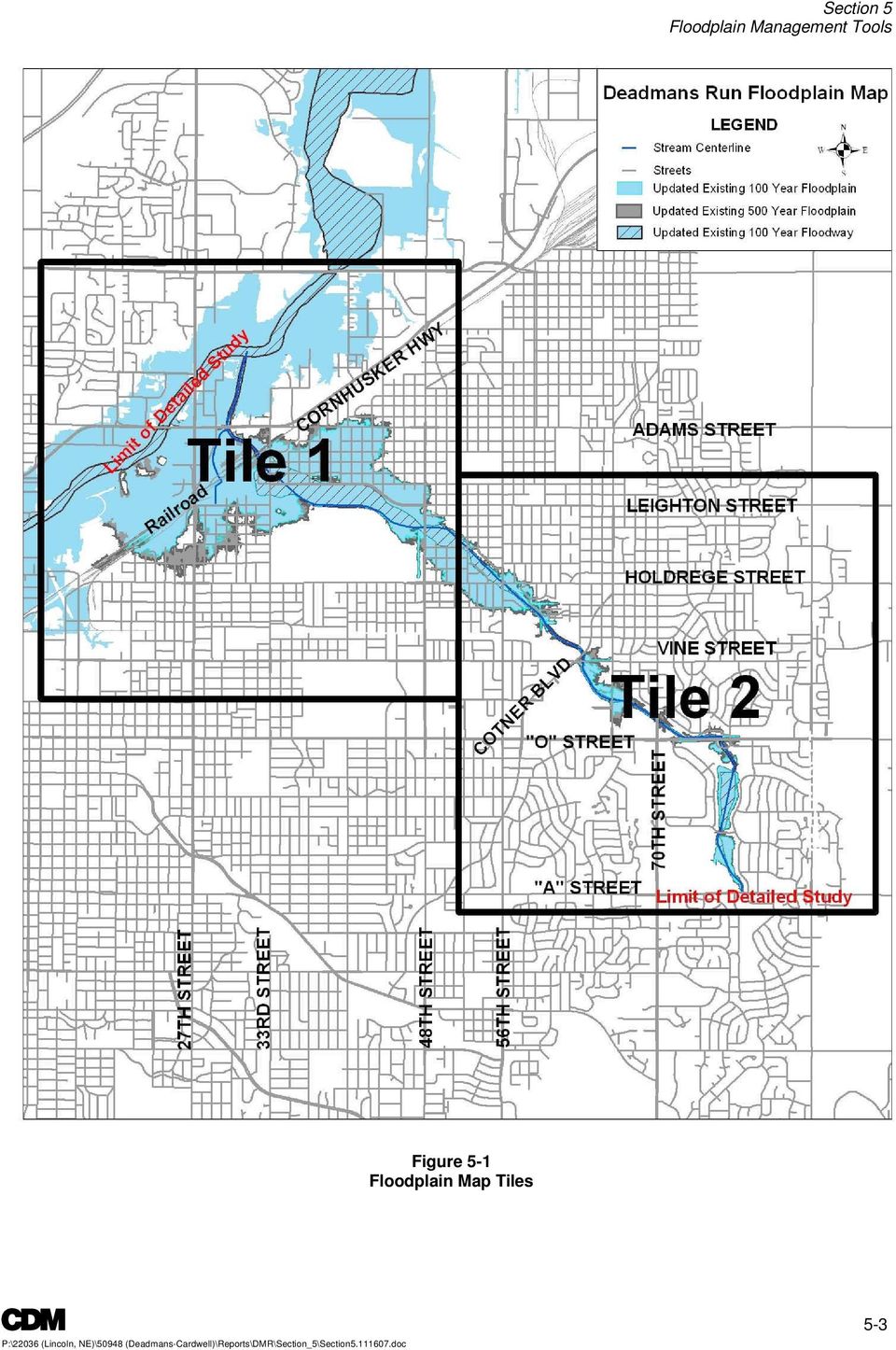
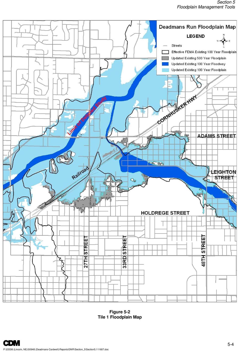
2 GIS data and HEC-RAS results. A manual quality control review was conducted to verify the accuracy of the automated process. The confluence of Deadmans Run with Salt Creek was not simulated with the HEC-RAS computer model. Per FEMA requirements, stream confluences are to be simulated with HEC-RAS only if coincident peaks occur, which is not the case within this watershed. To accurately map the Deadmans Run floodplain at the confluence of Salt Creek, a level pool process was performed. A comparison of the draft updated Salt Creek DFIRM, which is currently under FEMA review, was made with the Deadmans Run model results and the higher controlling flood stage was mapped. In general, the 100-year floodplain north of the railroad near Cornhusker Highway is controlled by Salt Creek Study Floodplain and Floodway Maps Figure 5-1 represents an overview map depicting the entire watershed divided into two floodplain maps. The study floodplain maps are based on existing land use and infrastructure as described in Section 3. Figure 5-2 and Figure 5-3 provide additional detail and a comparison of the extents of the current effective FEMA floodplain with the study s updated 100-year floodplain. In addition to the floodplain extents, Figure 5-4 provides illustration of the depth of flooding in the lower reach of the watershed along Huntington Avenue. The depth of potential flooding is 5 to 7 feet in many areas, which could result in significant property damage and potential loss of life if the 100-year storm occurred. 5-2

3 Figure 5-1 Floodplain Map Tiles 5-3
4 Figure 5-2 Tile 1 Floodplain Map 5-4
5 Figure 5-3 Tile 2 Floodplain Map 5-5

6 Figure 5-4 Depth of 100-Year Storm 5-6

July 20, 2015. Subject: 7 th Avenue Creek Project Update & Elevation Certificates
 July 20, 2015 Subject: 7 th Avenue Creek Project Update & Elevation Certificates Below are a few updates regarding the 7 th Avenue Creek Project. As you may recall there are two concurrent and independent
Criteria for Appeals of Flood Insurance Rate Maps
 Criteria for Appeals of Flood Insurance Rate Maps November 30, 2011 This document outlines the criteria for appealing proposed changes in flood hazard information on Flood Insurance Rate Maps (FIRMs)
What We Do: Wetlands, Wildlife Habitat & Flood Hazards in the Root River Watershed
 What We Do: Wetlands, Wildlife Habitat & Flood Hazards in the Root River Watershed presented by Ceil Strauss, State Floodplain Manager DNR Ecological & Water Resources 1 EWR Roles In Floodplains Regulatory:
CHICKASAW COUNTY, MISSISSIPPI, AND INCORPORATED AREAS
 CHICKASAW COUNTY, MISSISSIPPI, AND INCORPORATED AREAS Chickasaw County Community Name Community Number CHICKASAW COUNTY 280269 (UNINCORPORATED AREAS) HOUSTON, CITY OF 280030 NEW HOULKA, TOWN OF 280067
University of MT Helena College of Technology Helena, MT July 21, 2010. Image Courtesy Watershed Sciences, Inc.
 University of MT Helena College of Technology Helena, MT July 21, 2010 Image Courtesy Watershed Sciences, Inc. WELCOME INTRODUCTIONS Image Courtesy Watershed Sciences, Inc. Target Audience: Engineers,
How to Read a Flood Insurance Rate Map Tutorial. Developed September 2000 Updated June 2003
 How to Read a Flood Insurance Rate Map Tutorial Developed September 2000 Updated June 2003 Learning Objectives: The Objectives of the tutorial are: 1. To show the various types of flood maps, 2. To describe
How To Develop A Flood Risk Map
 Recommended Procedures for Flood Velocity Data Development November 2012 Federal Emergency Management Agency Department of Homeland Security 500 C Street, SW Washington, DC 20472 This document was prepared
ROSE CREEK WATERSHED HYDROLOGIC, HYDRAULIC, SEDIMENT TRANSPORT, AND GEOMORPHIC ANALYSES TASK 1 EXISTING DATA AND INFORMATION SUMMARY REPORT BACKGROUND
 ROSE CREEK WATERSHED HYDROLOGIC, HYDRAULIC, SEDIMENT TRANSPORT, AND GEOMORPHIC ANALYSES TASK 1 EXISTING DATA AND INFORMATION SUMMARY REPORT BACKGROUND The Rose Creek Watershed (RCW) consists of three planning
How To Build A Floodproofed Basement
 General Basement Exception Guidelines National Flood Insurance Program (NFIP) floodplain management criteria at 44 CFR 60.6 (c) provide for the granting of exceptions to permit construction of floodproofed
5.14 Floodplains and Drainage/Hydrology
 I-70 East Final EIS 5.14 Floodplains and Drainage/Hydrology 5.14 Floodplains and Drainage/Hydrology This section discusses floodplain and drainage/hydrology resources and explains why they are important
DANIELS RUN STREAM RESTORATION, FAIRFAX, VIRGINIA: FLOODPLAIN ANALYSIS REPORT
 DANIELS RUN STREAM RESTORATION, FAIRFAX, VIRGINIA: FLOODPLAIN ANALYSIS REPORT By: Conor C. Shea Stream Habitat Assessment and Restoration Program U.S. Fish and Wildlife Service CBFO-S07-01 Prepared in
Environmental Data Management Programs
 Hydrologic Engineering Centre (HEC) Software CD Collection of programs, developed by the U.S. Army Corps of Engineers Environmental Data Management Programs Name: HEC-DSS Package Purpose: Data Storage
NATIONAL FLOOD INSURANCE PROGRAM TRANSITION TO NAVD 88. Elmer C Knoderer, P. E. Dewberry & Davis 8401 Arlington Boulevard Fairfax, VA 22031-4666
 NATIONAL FLOOD INSURANCE PROGRAM TRANSITION TO NAVD 88 Elmer C Knoderer, P. E. Dewberry & Davis 8401 Arlington Boulevard Fairfax, VA 22031-4666 BIOGRAPHICAL SKETCH Elmer C Knoderer received his B. S. in
Guidance for Flood Risk Analysis and Mapping. Changes Since Last FIRM
 Guidance for Flood Risk Analysis and Mapping Changes Since Last FIRM May 2014 This guidance document supports effective and efficient implementation of flood risk analysis and mapping standards codified
WikiLeaks Document Release
 WikiLeaks Document Release February 2, 2009 Congressional Research Service Report R40073 FEMA Funding for Flood Map Modernization Wayne A. Morrissey, Information Research Specialist December 16, 2008 Abstract.
A Flood Warning System for City of Findlay, Ohio
 A Flood Warning System for City of Findlay, Ohio Matt Whitehead US Geological Survey, Ohio Water Science Center 6480 Doubletree Avenue Columbus, Ohio 43229 Abstract The U.S. Geological Survey (USGS) and
Town of Hingham. Changes to Flood Insurance Rate Maps and Flood Insurance Costs Frequently Asked Questions
 Town of Hingham 1. What is a floodplain? Changes to Flood Insurance Rate Maps and Flood Insurance Costs Frequently Asked Questions A floodplain is an area of land where water collects, pools and flows
The State of New Jersey. Fiscal Year 2004 Map Modernization Business Plan
 The State of New Jersey Fiscal Year 2004 Map Modernization Business Plan April 30, 2004 REGION II EXECUTIVE SUMMARY Introduction Historically, the State of New Jersey has taken a strong role in the development
DRAFT Map Modernization Plan for The State of Ohio. Prepared by The Ohio Department of Natural Resources Division of Water Columbus, Ohio
 DRAFT Map Modernization Plan for The State of Ohio Prepared by The Ohio Department of Natural Resources Division of Water Columbus, Ohio DRAFT Map Modernization State for Ohio DRAFT Ohio Map Modernization
Quality Assurance Reviews of Hydraulic Models Developed for the Central Valley Floodplain Evaluation and Delineation Program
 Quality Assurance Reviews of Hydraulic Models Developed for the Central Valley Floodplain Evaluation and Delineation Program Techniques Applied and Lessons Learned Seth Ahrens, P.E., CFM Selena Forman,
Release of EC 1110-2-6067 USACE Process for the National Flood Insurance Program (NFIP) Levee System Evaluation. Frequently Asked Questions
 Levee System Evaluation. Frequently Asked Questions") Release of EC 1110-2-6067 USACE Process for the National Flood Insurance Program (NFIP) Levee System Evaluation Frequently Asked Questions 1. What does Engineer Circular (EC) 1110-2-6067, USACE Process
Release of EC 1110-2-6067 USACE Process for the National Flood Insurance Program (NFIP) Levee System Evaluation Frequently Asked Questions 1. What does Engineer Circular (EC) 1110-2-6067, USACE Process
Adoption of Flood Insurance Rate Maps by Participating Communities
 Adoption of Flood Insurance Rate Maps by Participating Communities FEMA 495/September 2005 Adoption of Flood Insurance Rate Maps By Participating Communities The National Flood Insurance Program (NFIP)
COMPARING DSS-WISE- LITE TO OTHER DAM BREACH SOFTWARE
 National Dam Safety Program Technical Seminar No. 22 Dam Breach Modeling and Consequence Assessment National Emergency Training Center February 18-19, 2015 Emmitsburg, MD Brian Shane Cook, PE, LSIT formerly
Answers to Questions. For Property Owners Remapped Into Higher-Risk Flood Areas
 Answers to Questions For Property Owners Remapped Into Higher-Risk Flood Areas You have just been informed that the structure on your property may have been mapped into a higher risk flood zone, known
Town of Chatham Department of Community Development
 Town of Chatham Department of Community Development TOWN ANNEX 261 GEORGE RYDER ROAD 02633 CHATHAM, MA TELEPHONE (508) 945-5168 FAX (508) 945-5163 FEMA FLOOD MAP UPDATE & PROPOSED ZONING BYLAW AMENDMENT
Appendix F Benefit-Cost Analysis of Flood Protection Measures
 Appendix F Benefit-Cost Analysis of Flood Protection Measures Acronyms used in Appendix F: AA B AA C AA D BC BFE EAD FEMA NED O&M PV RED USACE Average Annual Benefits Average Annual Cost Average Annual
CDM. City of Jacksonville Master Stormwater Management Plan (MSMP) Update. December 2008 Update. Agenda. 1. Data Collection. 2.
 Update. December 2008 Update. Agenda. 1. Data Collection. 2.") City of Jacksonville Master Stormwater Management Plan (MSMP) Update December 2008 Update CDM Agenda 1. Data Collection 1. GIS/LiDAR 2. Survey 2. Water Quantity 1. SWMM Modeling 2. FEMA 3. Water Quality
City of Jacksonville Master Stormwater Management Plan (MSMP) Update December 2008 Update CDM Agenda 1. Data Collection 1. GIS/LiDAR 2. Survey 2. Water Quantity 1. SWMM Modeling 2. FEMA 3. Water Quality
Madison Preliminary Flood Map Open House Community Meeting
 Madison Preliminary Flood Map Open House Community Meeting December 9, 2010 INTRODUCTION Welcome to the Madison County, AL Preliminary Flood Map Open House Meeting The Office of Water Resources (OWR),
The answers to some of the following questions are separated into two major categories:
 Following the recent flooding events for Front Range communities in Colorado, property owners, communities, and the National Flood Insurance Program are being presented with some new challenges in the
FEMA Updates Flood Plain Information For 2006
 Flood Insurance Rate Map Changes Informational Meeting For Property Owners Entering the Floodplain Durant Center February 23, 2011 Introductions City of Alexandria Transportation and Environmental Services
Changing Flood Maps: A Guide for Homeowners and Consumers
 Changing Flood Maps: A Guide for Homeowners and Consumers The flood maps in your community are being changed. What does this mean to you? Flood maps, also known as Flood Insurance Rate Maps or FIRMs, are
MAP TYPES FLOOD HAZARD BOUNDARY MAP MAP READING & FLOOD INSURANCE STUDIES. FHBM Flood Hazard Boundary Map. FIRM Flood Insurance Rate Map
 FLOODPLAIN MANAGEMENT 101 MAP READING & FLOOD INSURANCE STUDIES MAP TYPES FHBM Flood Hazard Boundary Map FIRM Flood Insurance Rate Map FBFM Flood Boundary and Floodway Map DFIRM Digital Flood Insurance
Attachment 1 CARRUTHERS CREEK FLOOD MANAGEMENT and ANALYSIS DRAFT TERMS OF REFERENCE
 1.0 INTRODUCTION In early 2010, the Town of Ajax was provided with updated floodplain mapping for Carruthers Creek, based on a Regional Storm event (i.e., Hurricane Hazel), prepared by the Toronto and
UNION COUNTY, FLORIDA AND INCORPORATED AREAS
 UNION COUNTY, FLORIDA AND INCORPORATED AREAS COMMUNITY NAME COMMUNITY NUMBER LAKE BUTLER, CITY OF 120595 RAIFORD, TOWN OF 120593 UNION COUNTY 120422 (UNINCORPORATED AREAS) WORTHINGTON SPRINGS, CITY OF
USING DETAILED 2D URBAN FLOODPLAIN MODELLING TO INFORM DEVELOPMENT PLANNING IN MISSISSAUGA, ON
 22nd Canadian Hydrotechnical Conference 22e Conférence canadienne d hydrotechnique Water for Sustainable Development : Coping with Climate and Environmental Changes L eau pour le développement durable:
Using GIS Data With HEC-RAS
 C H A P T E R 14 Using GIS Data With HEC-RAS HEC-RAS has the ability to import three-dimensional (3D) river schematic and cross section data created in a GIS or CADD system. While the HEC- RAS software
NWS Flood Inundation Mapping Program
 NWS Flood Inundation Mapping Program Carson River Floodplain Management Forum April 22, 2015 Mark Faucette, Senior Forecaster Hydrology Program Manager NOAA/NWS, WFO Reno, NV NWS Hydrologic Services Program
Focus Areas: Program/Project Management, Repetitive Loss Properties, Flood Map Modernization, Standard Business Processes.
 NATIONAL FLOOD INSURANCE PROGRAM Focus Areas: Program/Project Management, Repetitive Loss Properties, Flood Map Modernization, Standard Business Processes. Sponsoring Executive: Lead Executive: Susan Shuback,
THE CAGIS CONSORTIUM DATA SERVICES PRICING POLICY
 THE CAGIS CONSORTIUM DATA SERVICES PRICING POLICY AMENDED BY THE CAGIS POLICY BOARD ON June 6 th, 2014 Effective date: July 1st 2014 PART A Preamble PART B REGARDING SALE OF DATA SERVICE PRODUCTS TABLE
Lincoln County Floodplain Development Permit Application
 Lincoln County Floodplain Development Permit Application Application # FP Use Permit Variance Appeal Date SECTION I: GENERAL PROVISIONS (APPLICANT to read and sign) 1. No work of any kind may start until
2D Modeling of Urban Flood Vulnerable Areas
 2D Modeling of Urban Flood Vulnerable Areas Sameer Dhalla, P.Eng. Dilnesaw Chekol, Ph.D. A.D. Latornell Conservation Symposium November 22, 2013 Outline 1. Toronto and Region 2. Evolution of Flood Management
Floodplain 8-Step Process in accordance with Executive Order 11988: Floodplain Management. New Jersey Department of Environmental Protection
 Floodplain 8-Step Process in accordance with Executive Order 11988: Floodplain Management New Jersey Department of Environmental Protection U.S. Department of Housing and Urban Development Community Development
Adoption of Flood Insurance Rate Maps by Participating Communities. FEMA 495 / September 2012
 Adoption of Flood Insurance Rate Maps by Participating Communities FEMA 495 / September 2012 Adoption of Flood Insurance Rate Maps by Participating Communities 1 Adoption of Flood Insurance Rate Maps by
Chapter 4 Flood Risk Management
 Chapter 4 Flood Risk Management Contents 1.0 Introduction... 1 2.0 Floodplain Management Fundamentals... 2 2.1 Basic Definitions... 2 2.1.1 Floodplain... 2 2.1.2 100-year Flood/Base Flood... 3 2.1.3 Base
Frequently-Asked Questions about Floodplains and Flood Insurance FLOOD INSURANCE
 Frequently-Asked Questions about Floodplains and Flood Insurance What is a floodplain? The floodplain is any area covered by water during normal water flows, and which could be inundated as a result of
Essex County, NJ. Preliminary Flood Insurance Study & Flood Insurance Rate Maps Release. FEMA Region 2 May 29, 2014
 Essex County, NJ Preliminary Flood Insurance Study & Flood Insurance Rate Maps Release FEMA Region 2 May 29, 2014 Agenda Introduction Review: Preliminary Work Maps (July 2013) Preliminary Flood Insurance
Challenges. Estimated Damages from 100-Year Flood
 Suffield Suffield is a rural community located along the Massachusetts border. It encompasses about 42.2 square miles and has a population of about 15,735. Suffield s terrain rises from an elevation of
Certified Floodplain Management and Land Development Design and Entitlement
 Certified Floodplain Management and Land Development Design and Entitlement J.R. EVANS ENGINEERING 23150 Fashion Drive, Ste. 242 Estero FL 33928 P 239.405.9148 F 239.288.2537 www.jreva ns eng ineering.com
Division of Water Frequently asked floodplain questions
 Division of Water Frequently asked floodplain questions Q: Where can I find copies of the floodplain mapping? A: Local floodplain administrators will have copies of the FEMA mapping. (Generally the local
CHAPTER 3 page 69 LOCAL FLOODPLAIN REGULATIONS AND NFIP STANDARDS
 CHAPTER 3 page 69 LOCAL FLOODPLAIN REGULATIONS AND NFIP STANDARDS LOCAL FLOODPLAIN REGULATIONS AND NFIP STANDARDS, page 69 THE PARTICIPATION OF A COMMUNITY IN THE NFIP IS MADE POSSIBLE BY ITS ADOPTION
OWNERS NAME PHONE OWNERS ADDRESS APPLICANTS NAME PHONE APPLICANTS ADDRESS
 TOWN OF SWANSBORO 502 Church Street, Swansboro, NC 28584 FLOODPLAIN DEVELOPMENT PERMIT OWNERS NAME PHONE OWNERS ADDRESS APPLICANTS NAME PHONE APPLICANTS ADDRESS Per Article 21, Section 21-7. Establishment
Prepared by. Drew Davidge
 Flood Damage Estimation in the Upper Thames River Watershed CFCAS project: Assessment of Water Resources Risk and Vulnerability to Changing Climatic Conditions Project Report VII. August 2005 Prepared
FEMA s FLOOD INSURANCE RATE MAPS
 My Lender is requiring me to purchase Flood Insurance Options for San Diego County Residents in Unincorporated Areas This document is intended to help San Diego County residents who have been contacted
Developed by: Charlotte-Mecklenburg Storm Water Services Charlotte-Mecklenburg Storm Water Services Flood Mitigation Program
 FLOODPLAIN REGULATIONS TECHNICAL GUIDANCE DOCUMENT To Prevent Loss of Life, Reduce Property Damage and Protect and Enhance the Natural and Beneficial Functions of Floodplains Developed for: The City of
Procedures for No-Rise Certification For Proposed Developments in the Regulatory Floodway
 US Department of Homeland Security Region X 130 228 th Street, SW Bothell, WA 98021 Procedures for No-Rise Certification For Proposed Developments in the Regulatory Floodway Section 60.3 (d) (3) of the
NAFSMA Position on Floodplain Management Issues
 National Association of Flood & Stormwater Management Agencies PO Box 56764, Washington, DC 20040 202-289-8625 www.nafsma.org I. Introduction NAFSMA Position on Floodplain Management Issues (Approved on
DEPARTMENT OF HOMELAND SECURITY FEDERAL EMERGENCY MANAGEMENT AGENCY STANDARD FLOOD HAZARD DETERMINATION FORM (SFHDF)
") Flood Determination The flood status of a property (and therefore the requirement for flood insurance) is based on whether a FEMA-designated Special Flood Hazard Area (100 year flood zone) touches a structure
Flood Determination The flood status of a property (and therefore the requirement for flood insurance) is based on whether a FEMA-designated Special Flood Hazard Area (100 year flood zone) touches a structure
The Federal Emergency Management Agency (FEMA) Map Modernization Program
 Map Modernization Program") The Federal Emergency Management Agency (FEMA) Map Modernization Program Compiled by: Moris Cabezas PBS&J Tampa, Florida Email: (Source - http://www.fema.gov/) 1 The Federal Emergency
The Federal Emergency Management Agency (FEMA) Map Modernization Program Compiled by: Moris Cabezas PBS&J Tampa, Florida Email: (Source - http://www.fema.gov/) 1 The Federal Emergency
Floodplain Management Today
 Newsletter Date Floodplain Management Today NEBRASKA DEPARTMENT OF NATURAL RESOURCES FLOODPLAIN SECTION FEBRUARY 2014 September 2013 Flooding After the significant rainfall in mid- September 2013 in the
Salem County, New Jersey Flood Hazard Mapping Status Report for Property Owners
 Salem County, New Jersey Flood Hazard Mapping Status Report for Property Owners Salem County, New Jersey Flood Hazard Mapping Status Report for Property Owners FLOOD INSURANCE Who Should Purchase Flood
James R. Williams, Nebraska Department of Natural Resources Frank Aebly, University of Nebraska at Lincoln
 Getting it Done- Project Management, Documentation, and Delivery James R. Williams, Nebraska Department of Natural Resources Frank Aebly, University of Nebraska at Lincoln Introduction The Nebraska Department
rescue and relief efforts in the aftermath of flooding, (iii) repair of flood damaged public facilities and utilities, and
 repair of flood damaged public facilities and utilities, and") 1. Purpose (1) It is the purpose of this Ordinance to protect human life, health, and property from flood conditions, to preserve the ability of floodplains to carry and discharge a base flood, and to
1. Purpose (1) It is the purpose of this Ordinance to protect human life, health, and property from flood conditions, to preserve the ability of floodplains to carry and discharge a base flood, and to
FLOODPLAIN DELINEATION IN MUGLA-DALAMAN PLAIN USING GIS BASED RIVER ANALYSIS SYSTEM
 FLOODPLAIN DELINEATION IN MUGLA-DALAMAN PLAIN USING GIS BASED RIVER ANALYSIS SYSTEM Dr. Murat Ali HATİPOĞLU Fatih KESKİN Kemal SEYREK State Hydraulics Works (DSI), Investigation and Planning Department
Page Intentionally Left Blank
 Flood Map Modernization Mid-Course Adjustment March 30, 2006 Page Intentionally Left Blank Table of Contents Executive Summary... iii 1. Introduction...1 1.1. Purpose of Report...1 1.2. Background...1
SIMPLIFIED INUNDATION MAPS FOR EMERGENCY ACTION PLANS. National Dam Safety Review Board Emergency Action Plan Workgroup
 SIMPLIFIED INUNDATION MAPS FOR EMERGENCY ACTION PLANS National Dam Safety Review Board Emergency Action Plan Workgroup EXECUTIVE SUMMARY Development of Emergency Action Plans (EAPs) for all high and significant
HYDROLOGIC/HYDRAULIC MODELING OF WESTMINSTER WATERSHED ORANGE COUNTY, CALIFORNIA
 HYDROLOGIC/HYDRAULIC MODELING OF WESTMINSTER WATERSHED ORANGE COUNTY, CALIFORNIA James Chieh, Ph.D., P.E., Senior Hydraulic Engineer, USACE, Los Angeles, California, Shih.H.Chieh@usace.army.mil; Jay Pak,
Fort Dodge Stormwater Master Planning. Prepared By: Ralph C. Stark, Jr., P.E., C.F.M. Joel N. Krause, P.E., C.F.M.
 Fort Dodge Stormwater Master Planning Prepared By: Ralph C. Stark, Jr., P.E., C.F.M. Joel N. Krause, P.E., C.F.M. Project Location Project Background Flooding History Localized flooding and storm sewer
Shooks Run Drainage Study Basic Terminology
 Shooks Run Drainage Study Basic Terminology PREPARED FOR: PREPARED BY: City of Colorado Springs CH2M DATE: April 9, 2015 Introduction This document is intended to provide an introduction to Colorado Springs
Mercer County, New Jersey Flood Hazard Mapping Status Report for Property Owners
 Mercer County, New Jersey Flood Hazard Mapping Status Report for Property Owners Mercer County, New Jersey Flood Hazard Mapping Status Report for Property Owners FLOOD INSURANCE Who Should Purchase Flood
GIS Tools for Proactive Urban Watershed Management
 GIS Tools for Proactive Urban Watershed Management Scott D. Bryant, PE *, Kenneth A. Carper, PE ** and John Nicholson, PhD *** *Manager & Chief Engineer, City of Greensboro Stormwater Management Division,
Community RiskMAP Questionnaire
 Community RiskMAP Questionnaire Please provide the following information County Date: Community Name/Organization: Your Your E-mail: Contact Preference: E-mail Phone Mail The Federal Emergency Management
TROPICAL STORM ALLISON. Prepared by: John P. Ivey, PE, CFM Halff Associates, Inc. ASCE
 TROPICAL STORM ALLISON June 5-9, 5 2001 Prepared by: John P. Ivey, PE, CFM Halff Associates, Inc. ASCE Spring 2002 Meeting Arlington, Texas March 27-30, 2002 Tropical Storm Allison (TSA) The most extensive
ROSEAU COUNTY, MINNESOTA
 Roseau County ROSEAU COUNTY, MINNESOTA AND INCORPORATED AREAS Community Name Community Number BADGER, CITY OF 270412 GREENBUSH, CITY OF 270413 *ROOSEVELT, CITY OF 270781 ROSEAU, CITY OF 270414 ROSEAU COUNTY
ROLE OF THE MODELING, MAPPING, AND CONSEQUENCES PRODUCTION CENTER
 ROLE OF THE MODELING, MAPPING, AND CONSEQUENCES PRODUCTION CENTER Russ Wyckoff, P.E., CFM, MMC Modeling Lead, Tulsa District, USACE, Tulsa, Oklahoma, russell.wyckoff@usace.army.mil ABSTRACT: The goal of
1. GENERAL ADVISORY BASE FLOOD ELEVATION (ABFE) QUESTIONS
 QUESTIONS") INTRODUCTION As communities begin to recover from the devastating effects of Hurricane Sandy, it is important to recognize lessons learned and to employ mitigation actions that ensure structures are rebuilt
INTRODUCTION As communities begin to recover from the devastating effects of Hurricane Sandy, it is important to recognize lessons learned and to employ mitigation actions that ensure structures are rebuilt
Monmouth County Preliminary Flood Insurance Study and Flood Insurance Rate Maps Release
 Monmouth County Preliminary Flood Insurance Study and Flood Insurance Rate Maps Release Thomas Song, Program Specialist FEMA Region 2 January 31, 2014 Agenda Introduction Review: Preliminary Work Maps
Mercer County, New Jersey Flood Hazard Mapping Status Report for Property Owners
 Mercer County, New Jersey Flood Hazard Mapping Status Report for Property Owners Mercer County, New Jersey Flood Hazard Mapping Status Report for Property Owners FLOOD INSURANCE Who Should Purchase Flood
INTEROFFICE MEMORANDUM DATE: October 15, 1997. Special Provisions for Construction in Special Flood Hazard Areas
 INTEROFFICE MEMORANDUM DATE: October 15, 1997 TO: FROM: SUBJECT: Staff Design Engineers, Roadway Design Division Brooks Booher, Staff Hydraulic Engineer Special Provisions for Construction in Special Flood
Flood Mitigation Workgroup Final Findings and Recommendations Part 1 Immediate Needs and Short-Term Plan. June 4, 2015
 Flood Mitigation Workgroup Final Findings and Recommendations Part 1 Immediate Needs and Short-Term Plan June 4, 2015 Background: On April 3, 2015, Louisville Metro experienced a significant rainstorm
AUTOMATION OF FLOOD HAZARD MAPPING BY THE FEDERAL EMERGENCY MANAGEMENT AGENCY ABSTRACT INTRODUCTION
 AUTOMATION OF FLOOD HAZARD MAPPING BY THE FEDERAL EMERGENCY MANAGEMENT AGENCY Daniel M. Cotter Federal Emergency Management Agency Federal Insurance Administration Office of Risk Assessment 500 C Street,
6.01 FEMA. 6.02 National Flood Insurance Program (NFIP)
") CHAPTER 6 FEMA AND FLOODPLAIN MANAGEMENT 6.01 FEMA The Federal Emergency Management Agency (FEMA) is an agency of the United States Department of Homeland Security. FEMA is tasked with responding to, planning
CHAPTER 6 FEMA AND FLOODPLAIN MANAGEMENT 6.01 FEMA The Federal Emergency Management Agency (FEMA) is an agency of the United States Department of Homeland Security. FEMA is tasked with responding to, planning
3. The submittal shall include a proposed scope of work to confirm the provided project description;
 QIN Shoreline Master Program Project Summary The Shoreline Master Program (SMP) development process for the Quinault Indian Nation (QIN) includes the completion of inventory and analysis report with corresponding
Revised Procedure Memorandum 13 - Document Control Procedures Manual
 US. Department of Homeland Security 500 C Street, SW Washington, DC 20472 (Originally Issued on July 20, 2000; Revised June 8, 2001) MEMORANDUM FOR: Mitigation Division Directors Regions I - X FROM: Matthew
LIDAR and Digital Elevation Data
 LIDAR and Digital Elevation Data Light Detection and Ranging (LIDAR) is being used by the North Carolina Floodplain Mapping Program to generate digital elevation data. These highly accurate topographic
Land Conservation in the Floodplain
 Land Conservation in the Floodplain Assessing the Benefits and Costs of Green Infrastructure Investments Margaret Walls Resources for the Future What is green infrastructure? Green infrastructure is strategically
Flood Damage Prevention in Delaware County, NY
 Flood Damage Prevention in Delaware County, NY Susquehanna Basin 2 Villages, 8 Hamlets Schoharie Basin 1 Hamlet Cannonsville Basin 4 Villages, 6 Hamlets Pepacton Basin 2 Villages, 6 Hamlets Upper Delaware
Frequently Asked Questions (FAQs) 1. Why is the City of Tucson getting new flood hazard maps? 2. Who is responsible for modernizing the maps?
 1. Why is the City of Tucson getting new flood hazard maps? 2. Who is responsible for modernizing the maps?") Frequently Asked Questions (FAQs) 1. Why is the City of Tucson getting new flood hazard maps? 2. Who is responsible for modernizing the maps? 3. What is a Flood Hazard Map? 4. What are the benefits of
Frequently Asked Questions (FAQs) 1. Why is the City of Tucson getting new flood hazard maps? 2. Who is responsible for modernizing the maps? 3. What is a Flood Hazard Map? 4. What are the benefits of
Levee Certification/Accreditation Process Cameron and Hidalgo Counties
 Levee Certification/Accreditation Process Cameron and Hidalgo Counties Lower Rio Grande Citizens Forum October 21, 2009 Larry Voice Background As administrator of the National Flood Insurance Program (NFIP),
PUBLIC NOTICE Application for Permit
 PUBLIC NOTICE Application for Permit 30-Day Notice Issue Date: June 20, 2016 Expiration Date: July 20, 2016 US Army Corps of Engineers No: NWP-2010-535 Oregon Department of State Lands No: 58311-RF Interested
RESPONSE TO COMMENTS AND SUGGESTIONS 2013 MODEL REGUATIONS September 3, 2013 version Montana Department of Natural Resources and Conservation
 RESPONSE TO COMMENTS AND SUGGESTIONS 2013 MODEL REGUATIONS September 3, 2013 version Montana Department of Natural Resources and Conservation February 24, 2013 A comment was to use consistently, either
APPENDIX 9-1 Project 1: City of Lompoc, Lompoc Valley Leak Detection and Repair Project
 APPENDIX 9 APPENDIX 9-1 Project 1: City of Lompoc, Lompoc Valley Leak Detection and Repair Project This project does not require an appendix to this attachment. APPENDIX 9-2 Project 2: City of Santa Maria,
Understanding Flood Map Modernization
 Understanding Flood USING PRELIMINARY FLOOD HAZARD MAPS RELEASING PRELIMINARY FLOOD HAZARD MAPS The release of preliminary flood hazard maps, or Digital Flood Insurance Rate Maps (DFIRMs), is an important
ORDINANCE NO. 618 BE IT ORDAINED AS FOLLOWS:
 ORDINANCE NO. 618 ORDINANCE OF THE MAYOR AND COUNCIL OF THE BOROUGH OF MANTOLOKING, OCEAN COUNTY, NEW JERSEY, PROVIDING FOR AMENDMENT OF ORDINANCE 525, FLOOD DAMAGE PREVENTION, AND REVISIONS OF CHAPTER
UNIT 5: THE NFIP FLOODPLAIN MANAGEMENT REQUIREMENTS
 UNIT 5: THE NFIP FLOODPLAIN MANAGEMENT REQUIREMENTS In this unit This unit reviews the NFIP standards for floodplain development, including: What maps, base flood elevations and other flood data must be
Time Allotted 1:50pm-2:23pm Agenda Topic Overview New Business
 Local Mitigation Strategy Working Group (LMS WG) Meeting- Communitywide Review Committee Stewardship: Hillsborough County Public Works Hazard Mitigation Program Meeting Summary Meeting Date Time October
Autodesk Solutions for Environmental Engineering. Engineering a better environment
 Autodesk Solutions for Environmental Engineering Engineering a better environment Better Engineering, Faster Design and deliver environmental engineering projects better, faster, and more economically.
Recent Innovations In Virginia Dam Safety & Floodplain Management Program
 Recent Innovations In Virginia Dam Safety & Floodplain Management Program Robert T. Bennett, P.E., R.A., C.F.M. Director Dam Safety & Floodplain Management Virginia Department of Conservation & Recreation
URBAN DRAINAGE CRITERIA
 URBAN DRAINAGE CRITERIA I. Introduction This division contains guidelines for drainage system design and establishes a policy for recognized and established engineering design of storm drain facilities
Floodplain Information
 Floodplain Information A large percentage of the Ellis community is located in the floodplain of Big Creek. The term floodplain means the low-lying areas on both sides of Big Creek that will be covered
Lower Raritan Watershed Management Area Stormwater & Flooding Subcommittee Strategy Worksheet LRSW-S3C1
 Strategy Name: Reduce Existing Potential for Flood Damages LRSW-S3C1. Develop and implement a program to: Minimize flood damages through the use of structural measures. Minimize flood damages through the