Teller County, Colorado Floodplain Development Permit Application
|
|
|
- Emmeline Cannon
- 8 years ago
- Views:
Transcription
1 Teller County, Colorado Floodplain Development Permit Application This is an application packet for a Floodplain Development Permit (FDP). Certain sections are to be completed by the Applicant, and certain sections are to be completed by the local Floodplain Administrator (FPA). The National Flood Insurance Program (NFIP) provides flood insurance to individuals at much lower premiums than could otherwise be purchased through private insurers, and makes certain federal monies available to local communities. In order for citizens to be eligible for the national flood insurance rates, or for communities to receive certain kinds of federal monies, the community must agree to meet minimum floodplain standards. This application packet is a tool to ensure that the minimum standards are met. In a participating NFIP community, flood insurance policies can be purchased from any local insurance agent at the national rate. Even though the policy may be issued as if it were coming from the insurance company you deal with, it is actually a Federal NFIP policy printed on the insurance agency s letterhead. The rates are determined by the flood risk zone in which you live and by the elevation of the lowest floor of your home, not by the insurance company, and should be the same regardless of which agent or agency sells you the insurance. You may buy flood insurance for your own peace of mind, you may be required to buy it before a lending institution will make or refinance a loan, or you may not be buying flood insurance at all. Whatever the case, if the property which you propose to develop is located within a Special Flood Hazard Area on a flood map issued by the Federal Emergency Management Agency (FEMA), you MUST obtain a FDP prior to beginning the project. This is a requirement of Floodplain Management Regulations of Teller County, Colorado (LUR 6.3). FDP s are ONLY required for developments in areas designated as Special Flood Hazard Areas of FEMA-issued flood maps. Flood maps can be reviewed at the office of your local FPA, or online at the FEMA website ( If you are proposing a development of any kind (constructing a new building, adding on to an existing building, clearing land, placing fill, grading land, mining, dredging, drilling, etc ) in a floodplain, you MUST submit Section I of this application for a Floodplain Development Permit to your local FPA. Depending upon the type of development you are proposing, additional forms may be required. For example, all new buildings in a Special Flood Hazard Area require an Elevation Certificate to document that the lowest floor of the building is elevated to a certain height relative to the anticipated flood crest of the base flood event. The Elevation Certificate and other forms are provided in Section III of this application packet, but should only be completed if they are required by the FPA for the proposed development. Typically, the Applicant completes Section I of this packet and submits the information to the local FPA. The FPA reviews the submission and determines whether or not additional information is needed. If it is, the FPA will request the additional information from the Applicant. Once all required materials have been submitted, the FPA will make a permitting decision and either issue or deny the requested Floodplain Development Permit. (Denied permits may be appealed per the provisions of the Floodplain Management Regulations.) The Applicant should understand that a FDP is only a permit to complete the proposed development. It is a permit to, for example, build a house, construct a baseball field, install a drainage ditch or septic system or grade a parcel of land. Before the house can actually be occupied, or the developed land used, a Compliance Certificate must be issued by the local FPA. The FPA will perform an inspection after the project is completed, or perhaps several inspections throughout the progress of the project, to make sure that the development is compliant with the requirements of the local Floodplain Management Regulations. Once the Compliance Certificate has been issued, the process has been completed.

2 INSTRUCTIONS FOR COMPLETION SECTION I SECTION II SECTION III General Information Self-explanatory. Note the last two items under this heading. Owner Information List the contact information for the owner(s) of the property where development is proposed. All owners of the property must sign the application. Applicant Information If you are applying for this development permit, but are not the owner of the property, list your contact information here. If you are the property owner, leave this section blank. Project Information Check the box(es) beside the type of development that is being proposed. Note that some types of activity require the estimated cost of the proposed project to be disclosed so the Floodplain Administrator (FPA) can determine whether or not the improvement is a substantial improvement. Signature Print your name, sign your name, and date the application. Floodplain Information The FPA will determine for the sole purpose of administering the local Floodplain Management Regulations the position of the proposed development relative to community floodplains and floodways. This determination is not binding at any lending institution or with any insurance agency, but is used to determine whether or not a FDP and/or any other forms are required prior to commencing the proposed project. Section II requires a map and panel number(s), a listing of the flood source for the proposed development, and contains a checklist of additional documents required for the FPA to make an informed permitting decision. If any of the additional documentation is required, the FPA is to notify the applicant, allow a reasonable length of time for submission of the documents, and then review all submissions to determine whether or not the permit will be issued. Forms Templates for forms that may be required are provided in this Section. Visit FEMA.gov for form completion directions. SECTION IV SECTION V Permit Determination The FPA will indicate whether or not the proposed development is conformant with the requirements of the regulations, and whether or not the requested permit is issued. If the decision is to NOT issue the permit, the FPA will provide an explanation of the perceived deficiencies to the Applicant. Certificate of Compliance The FPA will indicate the As-Built lowest floor elevation for structural developments, list any inspections that have been performed, and issue the Certificate of Compliance to the Applicant if appropriate.
 beside the type of development that is being proposed.")
3 TELLER COUNTY FLOODPLAIN DEVELOPMENT PERMIT APPLICATION FORM OFFICE USE ONLY Date Received: File Number: SECTION I: Applicant and Project Information GENERAL INFORMATION 1. No work of any kind may begin in a floodplain area designated as A, A1-30, AE, AO, AH, or B until a floodplain development permit is issued. 2. The permit may be revoked if any false statements are made in this application. 3. If revoked, all work must cease until a permit is re-issued. 4. The development may not be used or occupied until a Certificate of Compliance is issued. 5. The permit will expire if no work is commenced within 6 months of the date of issue. 6. The permit will not be issued until any other necessary local, state or federal permits have been obtained. 7. By signing and submitting this application, the Applicant gives consent to the local Floodplain Administrator or his/her representative to make reasonable inspections prior to the issuance of a Certificate of Compliance. 8. By signing and submitting this application, the Applicant certifies that all statements contained in SECTION I of the application, and in any additional attachments submitted by the Applicant, are true and accurate. OWNER INFORMATION Property owner(s): Telephone number: Fax number: Signature(s) of property owner(s) listed above 1 Mailing address: address: 1 Attached forms if there are additional property owners. This permit application will not be accepted without the signature of all property owners. The signature is an acknowledgement and consent to this floodplain development permit application. APPLICANT INFORMATION Applicant (print): Telephone number: Fax number: Notes: Signature of applicant listed above Section I continued on back

4 PROJECT INFORMATION Project Lot Block Address Subdivision Legal Description A. Structural development (Please check all that apply.) Type of Structure Residential (1 to 4 families) Residential (More than 4 families) Non-Residential Elevated Floodproofed Combined Use (Residential and Non-Residential Manufactured (mobile) Home Located within a Manufactured Home Park Located outside a Manufactured Home Park (Attach to this document) Type of Structural Activity New Structure Addition to Existing Structure 2 Alteration of Existing Structure 2 Relocation of Existing Structure 2 Demolition of Existing Structure Replacement of Existing Structure 2 Estimate Cost of Project B. Other Development Activities Excavation (not related to a Structural Development listed in Part A.) Clearing Placement of fill material 2 If the value of an addition or alteration to a Grading Structure equals or exceeds 50% of the value of Mining the structure before the addition or alteration, Drilling the entire structure must be treated as a sub- Dredging stantially improved structure. A relocated Watercourse alteration structure must be treated as new construction. Drainage improvement (including culvert work) Individual water or sewer system Roadway or bridge construction Other development not listed above (specify) SIGNATURE I certify that to the best of my knowledge the information contained in this application is true and accurate. (PRINTED name) (SIGNED name) (Date) File Number:

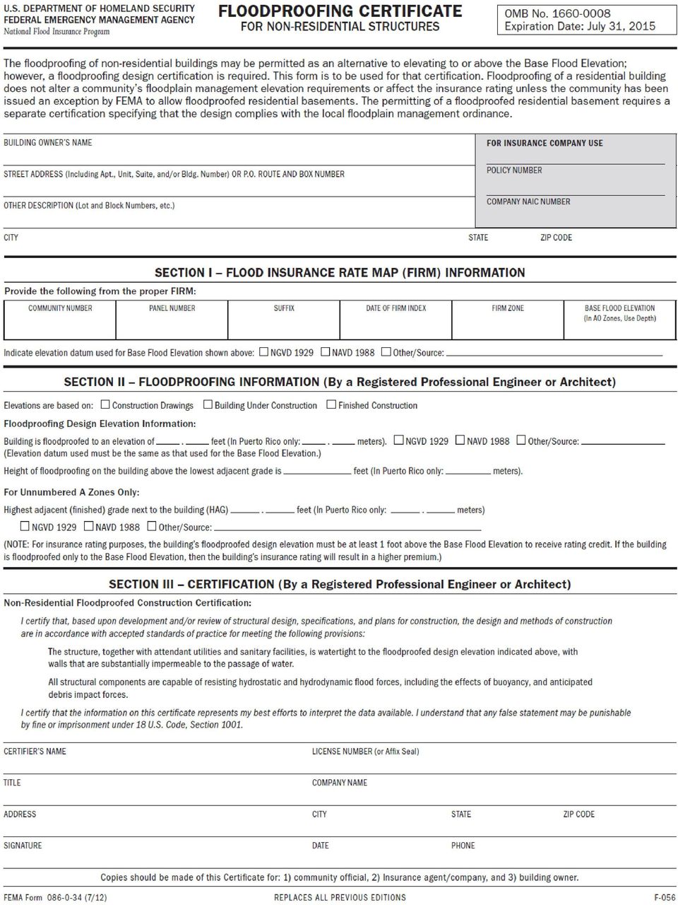
5 SECTION II: (To be completed by Floodplain Administrator) FLOOD INFORMATION 1 The proposed development is located on FIRM map panel: (number and suffix) 2 The date on the FIRM is 3 The proposed development is located in Zone: (A, A1-30, AE, AO, AH, B, C, D, or X) 4 Is the proposed development located in either of the following zones? A, A1-30, AE, AO, AH, B, or shaded X YES NO If NO, no permit FDP is required. 5 The proposed development requires CLOMR/LOMR. Adjacent communities notification YES NO (circle one) YES NO 6 If the proposed development is located within either Zone A1-30 or Zone AE, is it also located within a regulatory floodway? YES NO 7 If YES, a No Rise Certificate is necessary before proceeding. 8 If NO, continue. If the proposed development is located within Zones A, A1-30, AE, AO, AH, apply the criteria of the Floodplain Management Regulations (LUR 6.3) to minimize flood damages to the proposed Development and to adjacent properties as well. For structures, the provisions of the regulations specify that the lowest floor, including utilities, be elevated at least 1 foot above the base flood elevation. Therefore, it is necessary that the following information be provided: Base flood elevation at the site: feet above mean sea level (MSL) Vertical datum used in the Flood Insurance Study, on flood maps and in surveys is NAVD 88 NGVD 29 (circle one) Source of the base flood elevation (BFE) FIRM (flood map) Other sources of the BFE (specify): Flood Insurance Study Profile # 4. Proposed lowest floor elevation (including utilities): feet above MSL (This elevation must be greater than the BFE. For non-residential structures, floodproofing may be used for protection. See ordinance for details.) The following documents may be required. Check applicable. Maps and plans of the development An Elevation Certificate 3 required for all structures A Floodproofing Certificate 3 required if floodproofing a non-residential structure A No-Rise Certificate 3 if the proposed development is in a regulatory floodway An elevation study showing BFEs on developments exceeding 50 lots or 5 acres in Zone A A copy of Wetlands Permit from the U.S. Army Corps of Engineers if required; and other local, state, federal permits. Other permits: 3 Certificates require completion by a Professional Land Surveyor or Registered Professional Engineer, as indicated.
 YES NO 6 If the proposed development is located within either Zone A1-30 or Zone AE, is it also located within a regulatory floodway?")
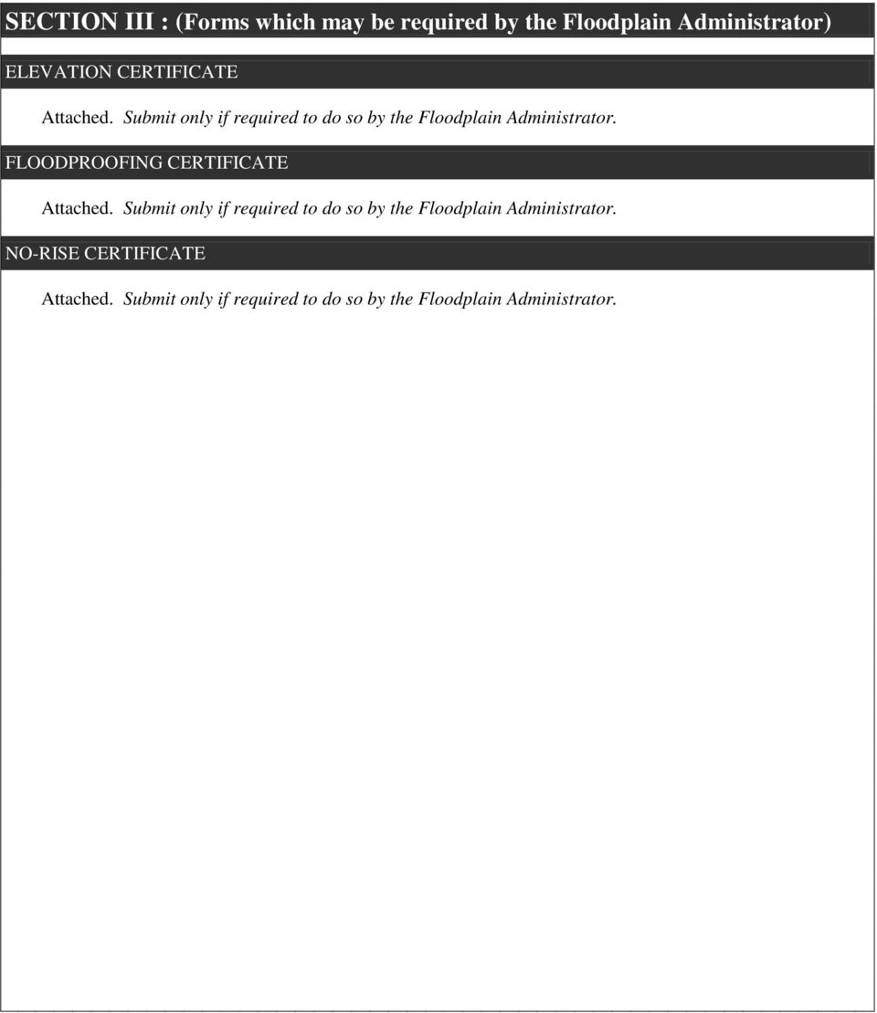
6 SECTION III : (Forms which may be required by the Floodplain Administrator) ELEVATION CERTIFICATE Attached. Submit only if required to do so by the Floodplain Administrator. FLOODPROOFING CERTIFICATE Attached. Submit only if required to do so by the Floodplain Administrator. NO-RISE CERTIFICATE Attached. Submit only if required to do so by the Floodplain Administrator.
7

8

9

10
11
12 ENGINEERING NO-RISE CERTIFICATE TELLER COUNTY, COLORADO File Number: SITE INFORMATION Community Applicant Address Telephone Project Address County Date Engineer Address Telephone Lot Subdivision Legal Description PROJECT INFORMATION Block Description of Development: Principal Use of Premises: FLOOD INSURANCE RATE MAP (FIRM) INFORMATION NFIP map(s) and panel(s) affected: Effective date of map: Base Flood Elevation on FIRM: Name of flooding source: CERTIFICATION This is to certify that I am a duly qualified Professional Engineer licensed to practice in the State of Colorado. I further certify that the attached engineering data supports the fact the proposed development would not result in any increase in flood levels within the community during the occurrence of a base flood event. CERTIFIER S NAME LICENSE NUMBER COMPANY NAME (seal) SIGNATURE DATE TITLE

13 File Number: SECTION IV : (To be completed by the Floodplain Administrator) PERMIT DETERMINATION I have determined that the proposed development IS IS NOT (non-conformances to be described in a separate document) in conformance with Floodplain Management Regulations, dated. The Floodplain Development Permit IS IS NOT (reasons for denial to be described in a separate document) issued, subject to any conditions attached to and made part of this permit. SIGNATURE DATE The applicant is reminded that this document is a development permit only. An inspection must be performed and a Compliance Certificate must be issued before the development can be occupied or used.

14 File Number: SECTION V : CERTIFICATE OF COMPLIANCE AS-BUILT ELEVATION (to be completed by the applicant after construction) The following information must be provided for structures that are part of this application. This section must be completed by a Professional Land Surveyor or a Professional Engineer (or attach a certification to this application). (1) The Actual ( As-Built ) elevation of the top of the lowest floor, including the basement, is Feet above MSL (vertical datum: ). (2) The Actual ( As-Built ) elevation of floodproofing protection is Feet above MSL (vertical datum: ). COMPLIANCE ACTION (to be completed by the Local Floodplain Administrator) The Floodplain Administrator will complete this section as applicable based on inspection of the development to ensure compliance with the community s local flood damage prevention ordinance. Inspections: Date: By: Deficiencies? Yes No Date: By: Deficiencies? Yes No Date: By: Deficiencies? Yes No Date: By: Deficiencies? Yes No Date: By: Deficiencies? Yes No CERTIFICATE OF COMPLIANCE (to be completed by the Local Floodplain Administrator) Certificate of Compliance issued. SIGNATURE DATE This Certificate of Compliance indicates that structures may now be occupied and nonstructural developments may be utilized.
 The Actual ( As-Built ) elevation of floodproofing protection is Feet above MSL (vertical datum: ).")
CITY OF PITTSBURGH Department of City Planning 200 Ross Street, Pittsburgh, PA 15219 412-255-2241 412-255-2561(fax)
") CITY OF PITTSBURGH Department of City Planning 200 Ross Street, Pittsburgh, PA 15219 412-255-2241 412-255-2561(fax) APPLICATION Construction and Development In the Flood Plain Overlay District This is
CITY OF PITTSBURGH Department of City Planning 200 Ross Street, Pittsburgh, PA 15219 412-255-2241 412-255-2561(fax) APPLICATION Construction and Development In the Flood Plain Overlay District This is
Lincoln County Floodplain Development Permit Application
 Lincoln County Floodplain Development Permit Application Application # FP Use Permit Variance Appeal Date SECTION I: GENERAL PROVISIONS (APPLICANT to read and sign) 1. No work of any kind may start until
Floodplain Development Land Use Review
 COMMUNITY DEVELOPMENT DEPARTMENT Planning Division P.O. Box 490 333 Broadalbin Street SW Albany, OR 97321 Phone 541-917-7550 Fax 541-791-0150 www.cityofalbany.net Floodplain Development Land Use Review
Permit Application No. Development Address. Legal Description. A. Flood Plain and Floodway Information and Sources: (To be completed with Staff)
") FLOOD PLAIN DEVELOPMENT PERMIT APPLICATION of Olathe, Department of Public Works 1385 S. Robinson Drive P.O. Box 768 Olathe, Kansas 66051-0768 (913) 971-9045 FAX (913) 971-9099 Olathe, Kansas, Community
FLOOD PLAIN DEVELOPMENT PERMIT APPLICATION of Olathe, Department of Public Works 1385 S. Robinson Drive P.O. Box 768 Olathe, Kansas 66051-0768 (913) 971-9045 FAX (913) 971-9099 Olathe, Kansas, Community
OWNERS NAME PHONE OWNERS ADDRESS APPLICANTS NAME PHONE APPLICANTS ADDRESS
 TOWN OF SWANSBORO 502 Church Street, Swansboro, NC 28584 FLOODPLAIN DEVELOPMENT PERMIT OWNERS NAME PHONE OWNERS ADDRESS APPLICANTS NAME PHONE APPLICANTS ADDRESS Per Article 21, Section 21-7. Establishment
OKANOGAN COUNTY OFFICE OF PLANNING AND DEVELOPMENT FLOODPLAIN DEVELOPMENT PERMIT APPLICATION
 OKANOGAN COUNTY OFFICE OF PLANNING AND DEVELOPMENT FLOODPLAIN DEVELOPMENT PERMIT APPLICATION Okanogan County Code, OCC 15.08, Floodplain Management The State of Washington has authorized county governments
Elevation Certificate Completion Guide
 Elevation Certificate Completion Guide General Comment: The latest FEMA Elevation Certificate form must be used. The form can be downloaded directly from the FEMA website (FEMA.gov). All information requested
SECTION 15 FLOODPLAIN MANAGEMENT
 SECTION 15 15.1 Purpose Certain areas of the City of Gardiner, Maine, are subject to periodic flooding, causing serious damages to properties within these areas. Relief is available in the form of flood
Permits for Development within Floodplains
 For More Information OKLAHOMA Oklahoma Water Resources Board 3800 N. Classen Boulevard Oklahoma City, OK 73118 (405) 530-8800 www.owrb.ok.gov Bulletin No. 2 FLOODPLAIN MANAGEMENT INFORMATION SERIES Lawton
How To Build A Floodproofed Basement
 General Basement Exception Guidelines National Flood Insurance Program (NFIP) floodplain management criteria at 44 CFR 60.6 (c) provide for the granting of exceptions to permit construction of floodproofed
Administrative Procedures Regarding the Application of Flood Damage Prevention
 Administrative Procedures Regarding the Application of Flood Damage Prevention A floodplain development permit, conforming to the provisions of the Flood Damage Prevention Ordinance ( the Ordinance, shall
MT-EZ. Amendments to National Flood Insurance Program Maps. Application Form for Single Residential Structure Lot. FEMA Form 81-92 Series August 2004
 MT-EZ Amendments to National Flood Insurance Program Maps Application Form for Single Residential Structure Lot FEMA Form 81-92 Series August 2004 AMENDMENTS TO NATIONAL FLOOD INSURANCE PROGRAM MAPS APPLICATION
Agenda. Presenter. The Current Form. Adobe Fillable Form. Elevation Certificates FEMA Form 81-31. Elevation Certificates Training 11/14/2013
 NORFMA Floodplain Conference November 14, 2013 Boise, Idaho Agenda Introductions & Housekeeping Overview Basics of FEMA Form 81-31 Building Diagrams Exercise Common Errors Using ECs in Floodplain Development
FLOOD DAMAGE PREVENTION ORDINANCE
 FLOOD DAMAGE PREVENTION ORDINANCE SECTION 1.0 STATUTORY AUTHORIZATION, FINDINGS FO FACT, PURPOSE, AND OBJECTIVES 1.1 STATUTORY AUTHORIZATION The Legislature of the State of Washington has in RCW delegated
Substantial Improvement/Substantial Damage for Floodplain Administrators Mitigation Fact Sheet
 Substantial Improvement/Substantial Damage for Floodplain Administrators Mitigation Fact Sheet Substantial Improvement/Substantial Damage are everyday issues, not just post-disaster; and they apply to
DEPARTMENT OF PLANNING AND DEVELOPMENT
 DEPARTMENT OF PLANNING AND DEVELOPMENT FLOODPLAIN DEVELOPMENT PERMIT APPLICATION FOR NON-RESIDENTIAL DEVELOPMENT Property Owner Telephone Street/P.O. Box City State ZIP Agent (if any) Relationship to Property
EXISTING STRUCTURES 1) FAIR MARKET VALUE OF STRUCTURE(s) BEFORE IMPROVEMENT: 2) COST OF IMPROVEMENTS:
 FAIR MARKET VALUE OF STRUCTURE(s) BEFORE IMPROVEMENT: 2) COST OF IMPROVEMENTS:") Date Received: Received By: Project/Permit Number: Fee: (To be Completed by MOA) FLOOD HAZARD PERMIT APPLICATION (Please fill out application completely; Indicate NA if necessary. Property information
Date Received: Received By: Project/Permit Number: Fee: (To be Completed by MOA) FLOOD HAZARD PERMIT APPLICATION (Please fill out application completely; Indicate NA if necessary. Property information
Control filling, grading, dredging, and other development which may increase erosion or flood damage; and
 ARTICLE 16. FLOOD DAMAGE PREVENTION Section 16-1: Findings of Fact The flood hazard areas of the Town of Lillington are subject to periodic inundation which results in loss of life and property, health
PREVENTION. City of Orem FLOOD DAMAGE PREVENTION 10-1-1
 City of Orem FLOOD DAMAGE PREVENTION 10-1-1 CHAPTER 10. Article 10-1. Article 10-2. Article 10-3. Article 10-4. Article 10-5. FLOOD DAMAGE PREVENTION Purposes Definitions General Provisions Administration
CHAPTER 3 page 69 LOCAL FLOODPLAIN REGULATIONS AND NFIP STANDARDS
 CHAPTER 3 page 69 LOCAL FLOODPLAIN REGULATIONS AND NFIP STANDARDS LOCAL FLOODPLAIN REGULATIONS AND NFIP STANDARDS, page 69 THE PARTICIPATION OF A COMMUNITY IN THE NFIP IS MADE POSSIBLE BY ITS ADOPTION
FEMA s FLOOD INSURANCE RATE MAPS
 My Lender is requiring me to purchase Flood Insurance Options for San Diego County Residents in Unincorporated Areas This document is intended to help San Diego County residents who have been contacted
UNIT 5: THE NFIP FLOODPLAIN MANAGEMENT REQUIREMENTS
 UNIT 5: THE NFIP FLOODPLAIN MANAGEMENT REQUIREMENTS In this unit This unit reviews the NFIP standards for floodplain development, including: What maps, base flood elevations and other flood data must be
Kentucky Model Flood Damage Prevention Ordinance. 2015 KAMM Annual Conference Carey Johnson Kentucky Division of Water
 Kentucky Model Flood Damage Prevention Ordinance 2015 KAMM Annual Conference Carey Johnson Kentucky Division of Water Flood Damage Prevention Ordinance Also referred to as Floodplain Management Ordinance
FEMA Updates Flood Plain Information For 2006
 Flood Insurance Rate Map Changes Informational Meeting For Property Owners Entering the Floodplain Durant Center February 23, 2011 Introductions City of Alexandria Transportation and Environmental Services
Relationship between Floodplain Management and Flood Insurance
 Relationship between Floodplain Management and Flood Insurance The National Flood Insurance Program [is] a voluntary program based on a mutual agreement between the Federal government and the local community:
Floodproof Construction Requirements
 Floodproof Construction Requirements CITY OF FARGO BUILDING INSPECTION DIVISION Updated April 2015 The State of North Dakota requires that you call 1-800-795-0555 at least two business days before you
1. Why is Lee County getting new flood hazard maps? 3. What are the benefits of the new flood hazard maps?
 1. Why is Lee County getting new flood hazard maps? Flood hazard maps, also known as Flood Insurance Rate Maps (FIRMs), are important tools in the effort to protect lives and property. They indicate the
4. Minimize expenditure of public money for costly flood control projects;
 3.7.200 Flood Damage Prevention A. Statutory authorization. The State of Oregon has delegated the responsibility to local governmental units to adopt regulations designed to promote the public health,
APPLICATION FORMS FOR CONDITIONAL AND FINAL LETTERS OF MAP AMENDMENT AND LETTERS OF MAP REVISION BASED ON FILL
 APPLICATION FORMS FOR CONDITIONAL AND FINAL LETTERS OF MAP AMENDMENT AND LETTERS OF MAP REVISION BASED ON FILL General Background Information In 1968, the U.S. Congress passed the National Flood Insurance
rescue and relief efforts in the aftermath of flooding, (iii) repair of flood damaged public facilities and utilities, and
 repair of flood damaged public facilities and utilities, and") 1. Purpose (1) It is the purpose of this Ordinance to protect human life, health, and property from flood conditions, to preserve the ability of floodplains to carry and discharge a base flood, and to
1. Purpose (1) It is the purpose of this Ordinance to protect human life, health, and property from flood conditions, to preserve the ability of floodplains to carry and discharge a base flood, and to
SPECIAL PURPOSE FLOOD DAMAGE REDUCTION RESOLUTION MUSKINGUM COUNTY, OHIO
 SPECIAL PURPOSE FLOOD DAMAGE REDUCTION RESOLUTION MUSKINGUM COUNTY, OHIO SECTION 1.0: GENERAL PROVISIONS 1.1 Statutory Authorization This resolution is adopted pursuant to authorization contained in Sections
FLOOD DAMAGE PREVENTION CODE FOR CITY OF BETHEL HEIGHTS 09-28-07
 FLOOD DAMAGE PREVENTION CODE FOR CITY OF BETHEL HEIGHTS 09-28-07 ARTICLE 1 DEFINITIONS Unless specifically defined below, words or phrases used in this Code have their common usage meaning to give the
Division of Water Frequently asked floodplain questions
 Division of Water Frequently asked floodplain questions Q: Where can I find copies of the floodplain mapping? A: Local floodplain administrators will have copies of the FEMA mapping. (Generally the local
Criteria for Appeals of Flood Insurance Rate Maps
 Criteria for Appeals of Flood Insurance Rate Maps November 30, 2011 This document outlines the criteria for appealing proposed changes in flood hazard information on Flood Insurance Rate Maps (FIRMs)
April 2, 2009. Write Your Own (WYO) Company Principal Coordinators and NFIP Servicing Agent
 Company Principal Coordinators and NFIP Servicing Agent") U.S. Department of Homeland Security 500 C Street SW Washington, DC 20472 W-09020 April 2, 2009 MEMORANDUM TO: Write Your Own (WYO) Company Principal Coordinators and NFIP Servicing Agent FROM: SUBJECT:
U.S. Department of Homeland Security 500 C Street SW Washington, DC 20472 W-09020 April 2, 2009 MEMORANDUM TO: Write Your Own (WYO) Company Principal Coordinators and NFIP Servicing Agent FROM: SUBJECT:
Floodplain Information
 Floodplain Information A large percentage of the Ellis community is located in the floodplain of Big Creek. The term floodplain means the low-lying areas on both sides of Big Creek that will be covered
SPECIAL PURPOSE FLOOD DAMAGE REDUCTION RESOLUTION BELMONT COUNTY, OHIO
 SECTION 1.0: GENERAL PROVISIONS SPECIAL PURPOSE FLOOD DAMAGE REDUCTION RESOLUTION BELMONT COUNTY, OHIO 1.1 Statutory Authorization This resolution is adopted pursuant to authorization contained in Sections
CITY OF MIDDLETOWN, OHIO FLOOD DAMAGE PREVENTION REGULATIONS
 CITY OF MIDDLETOWN, OHIO FLOOD DAMAGE PREVENTION REGULATIONS October 2010 TABLE OF CONTENTS SECTION General Provisions Introduction... 1 Statement of Purpose... 1 Methods of Reducing Flood Loss... 1-2
PRELIMINARY DIGITAL FLOOD INSURANCE RATE MAPS (DFIRM)
") INTRODUCTION This Mississippi Guidance document has been prepared to explain to community officials how the Preliminary Digital Flood Insurance Rate Maps (DFIRMs) and Preliminary Flood Insurance Study
INTRODUCTION This Mississippi Guidance document has been prepared to explain to community officials how the Preliminary Digital Flood Insurance Rate Maps (DFIRMs) and Preliminary Flood Insurance Study
Frequently-Asked Questions about Floodplains and Flood Insurance FLOOD INSURANCE
 Frequently-Asked Questions about Floodplains and Flood Insurance What is a floodplain? The floodplain is any area covered by water during normal water flows, and which could be inundated as a result of
Updated Federal Emergency Management Agency Flood Insurance Rate Maps and Zoning Ordinance Update. July 16, 2015 Policy Committee
 Updated Federal Emergency Management Agency Flood Insurance Rate Maps and Zoning Ordinance Update July 16, 2015 Policy Committee FEMA Map Update Costal Analysis and mapping study by FEMA in 2009 Changes
ALAMANCE COUNTY FLOOD DAMAGE PREVENTION ORDINANCE
 ALAMANCE COUNTY FLOOD DAMAGE PREVENTION ORDINANCE Originally adopted by THE BOARD OF COUNTY COMMISSIONERS August 15, 1994 FLOOD DAMAGE PREVENTION ORDINANCE Table of Contents ARTICLE 1. STATUTORY AUTHORIZATION,
Floodplain 8-Step Process in accordance with Executive Order 11988: Floodplain Management. New Jersey Department of Environmental Protection
 Floodplain 8-Step Process in accordance with Executive Order 11988: Floodplain Management New Jersey Department of Environmental Protection U.S. Department of Housing and Urban Development Community Development
NATIONAL FLOOD INSURANCE PROGRAM TRANSITION TO NAVD 88. Elmer C Knoderer, P. E. Dewberry & Davis 8401 Arlington Boulevard Fairfax, VA 22031-4666
 NATIONAL FLOOD INSURANCE PROGRAM TRANSITION TO NAVD 88 Elmer C Knoderer, P. E. Dewberry & Davis 8401 Arlington Boulevard Fairfax, VA 22031-4666 BIOGRAPHICAL SKETCH Elmer C Knoderer received his B. S. in
Custer County Flood Damage Prevention Ordinance
 Custer County Flood Damage Prevention Ordinance Table of Contents I. STATUTORY AUTHORIZATION, FINDINGS OF FACT, PURPOSE, AND OBJECTIVES... 1 A. Statutory Authority... 1 B. Findings of Fact... 1 C. Statement
ARTICLE VII COUNTY FLOOD DAMAGE PREVENTION OVERLAY DISTRICT
 AMENDED IN ITS ENTIRETY ON OCTOBER 9, 2006 BY RESOLUTION NO. 06/10/94 AMENDED ON MARCH 16, 2009 BY RESOLUTION NO. 09/03/160 AMENDED IN ITS ENTIRETY ON DECEMBER 15, 2014 BY RESOLUTION NO. 14/12/300 ARTICLE
CASS COUNTY COMMISSION POLICY MANUAL 38.07 ADOPTED DATE: FEBRUARY 2, 1998 PAGE 1 OF 9
 CASS COUNTY COMMISSION POLICY MANUAL 38.07 SUBJECT: ORDINANCE #1998-2 (FLOOD DAMAGE PREVENTION) ADOPTED DATE: FEBRUARY 2, 1998 PAGE 1 OF 9 NORTH DAKOTA COUNTY OF CASS ORDINANCE #1998-2 Be it ordained and
CITY OF NORTHWEST FLOOD DAMAGE PREVENTION ORDINANCE. Non-Coastal Regular Phase
 CITY OF NORTHWEST FLOOD DAMAGE PREVENTION ORDINANCE Non-Coastal Regular Phase ARTICLE 1. STATUTORY AUTHORIZATION, FINDINGS OF FACT, PURPOSE AND OBJECTIVES. SECTION A. STTUTORY AUTHORIZATION. Municipal:
Changing Flood Maps: A Guide for Homeowners and Consumers
 Changing Flood Maps: A Guide for Homeowners and Consumers The flood maps in your community are being changed. What does this mean to you? Flood maps, also known as Flood Insurance Rate Maps or FIRMs, are
Elevations Certificates: Update 2009 Presented by Wendy Lathrop, PLS, CFM
 Elevations Certificates: Update 2009 Presented by Wendy Lathrop, PLS, CFM The objectives of the National Flood Insurance Program (NFIP): Reduce the exposure to flood damages through the use of minimum
PIMA COUNTY REGIONAL FLOOD CONTROL DISTRICT TECHNICAL PROCEDURE
 PIMA COUNTY REGIONAL FLOOD CONTROL DISTRICT TECHNICAL PROCEDURE TECHNICAL PROCEDURE TECH-113 EFFECTIVE DATE: 5/23/2007 REVISED DATE(S): 1/16/2008, 11/30/2009, 2/2/2012, 7/17/2014 PROCEDURE TITLE: Elevation
FREQUENTLY ASKED QUESTIONS
 FREQUENTLY ASKED QUESTIONS What factors determine flood insurance premiums? A number of factors determine premiums for National Flood Insurance Program (NFIP) insurance coverage. Major factors include
Flood Insurance Coverage/Rates Summary Excerpted From Unit 9 of Managing Floodplain Development Through the National Flood Insurance Program
 Flood Insurance Coverage/Rates Summary Excerpted From Unit 9 of Managing Floodplain Development Through the National Flood Insurance Program Amount of coverage Insurance rates for all buildings are based
240, FLOOD DAMAGE PREVENTION [HISTORY:
 Chapter 240, FLOOD DAMAGE PREVENTION [HISTORY: Adopted by the City Council of the City of Binghamton 4-20-1987 by L.L. No. 5-1987 (Sub-Part LXVI of the 1970 Code). Amendments noted where applicable.] GENERAL
B. Minimize expenditure of public money for costly flood control projects.
 Chapter 167, FLOOD DAMAGE PREVENTION [HISTORY: Adopted by the Board of Trustees of the Village of Scarsdale 5-26-1987 by L.L. No. 8-1987. Amendments noted where applicable.] ARTICLE I, General Provisions
LOWEST FLOOR GUIDE I. LOWEST FLOOR DETERMINATION
 LOWEST FLOOR GUIDE This section is to be used as a guide for identifying the lowest floor for rating buildings being considered for coverage under the National Flood Insurance Program (NFIP). I. LOWEST
Frequently Asked Questions (FAQs)
") 1. Why is Wellesley getting new flood plain maps? Flood plain or flood hazard maps, also known as Flood Insurance Rate Maps (FIRMs), are important tools in the effort to protect lives and properties in
1. Why is Wellesley getting new flood plain maps? Flood plain or flood hazard maps, also known as Flood Insurance Rate Maps (FIRMs), are important tools in the effort to protect lives and properties in
POLK COUNTY FLOOD DAMAGE PREVENTION ORDINANCE
 POLK COUNTY FLOOD DAMAGE PREVENTION ORDINANCE ARTICLE 1. SECTION A. STATUTORY AUTHORIZATION, FINDINGS OF FACT, PURPOSE AND OBJECTIVES. STATUTORY AUTHORIZATION. The Legislature of the State of North Carolina
Chapter 159: Alexander County Flood Damage Prevention Ordinance Page 1 of 28 PURPOSE AND INTENT
 Chapter 159: Alexander County Flood Damage Prevention Ordinance Page 1 of 28 PURPOSE AND INTENT 159.001 STATUTORY AUTHORIZATION. The Legislature of the State of North Carolina has in Part 6, Article 21
New Hanover County Flood Damage Prevention Ordinance
 New Hanover County Flood Damage Prevention Ordinance Adopted by the New Hanover County Board of County Commissioners June 5, 2006 TABLE OF CONTENTS ARTICLE 1. STATUTORY AUTHORIZATION, FINDINGS OF FACT,
City of Roxboro 105 S. Lamar St. Roxboro, North Carolina 27573. National Flood Insurance. Flood Damage Prevention Ordinance
 City of Roxboro 105 S. Lamar St. Roxboro, North Carolina 27573 National Flood Insurance Flood Damage Prevention Ordinance Adopted May 8, 2007 TABLE OF CONTENTS ARTICLE 1. Statutory Authorization, Findings
TITLE XV: LAND USAGE 150. BUILDING CODE 151. FLOOD DAMAGE PREVENTION 153. SUBDIVISION REGULATIONS 154. ZONING CODE
 TITLE XV: LAND USAGE Chapter 150. BUILDING CODE 151. FLOOD DAMAGE PREVENTION 152. MOBILE HOMES AND TRAILER PARKS 153. SUBDIVISION REGULATIONS 154. ZONING CODE 2001 S-7 1 2 Middletown - Land Usage CHAPTER
TITLE 8 FLOOD DAMAGE PREVENTION
 Henry County Development Code Flood Damage Prevention TITLE 8 FLOOD DAMAGE PREVENTION SECTION 1.0 FLOOD DAMAGE PREVENTION: STATUTORY AUTHORIZATION The Indiana Legislature granted the power to local units
FLOOD DAMAGE PREVENTION TOWN OF GORHAM Chapter 45
 FLOOD DAMAGE PREVENTION TOWN OF GORHAM Chapter 45 {History: Adopted by the Town Board of the Town of Gorham, Local Law #3-87; Repealed in entirety and and new Local Law #3-96 adopted.} Table of Contents
SECTION 1.0 STATUTORY AUTHORIZATION AND PURPOSE
 A local law for Flood Damage Prevention as authorized by the New York State Constitution, Article IX, Section 2, and Environmental Conservation Law, Article 36 1.1 FINDINGS SECTION 1.0 STATUTORY AUTHORIZATION
FLOOD DAMAGE PREVENTION ORDINANCE ARTICLE 1. STATUTORY AUTHORIZATION, FINDINGS OF FACT, PURPOSE AND OBJECTIVES
 FLOOD DAMAGE PREVENTION ORDINANCE ARTICLE 1. STATUTORY AUTHORIZATION, FINDINGS OF FACT, PURPOSE AND OBJECTIVES SECTION A. AUTHORIZATION Article IX, Section II of the Constitution of the State of Georgia
FLOOD DAMAGE PREVENTION ORDINANCE
 FLOOD DAMAGE PREVENTION ORDINANCE SECTION 1. STATUTORY AUTHORIZATION FINDING OF FACT PURPOSE AND OBJECTIVES. 1.1 STATUTORY AUTHORIZATION The Legislature of the State of Connecticut has in Section 7-148
FLOOD DAMAGE PREVENTION ORDINANCE
 FLOOD DAMAGE PREVENTION ORDINANCE Section 1. Purpose and Objectives This ordinance, when adopted shall replace the Flood Damage Prevention Ordinance of June 10, 1998. It is the purpose of this ordinance
TITLE XVI: FLOOD DAMAGE PREVENTION Chapter 16.01. FLOOD DAMAGE PREVENTION
 TITLE XVI: FLOOD DAMAGE PREVENTION Chapter 16.01. FLOOD DAMAGE PREVENTION 2 River Bend Flood Plain Damage Prevention Flood Plain Damage Prevention 3 CHAPTER 16.01 FLOOD PLAIN DAMAGE PREVENTION Added 02/21/08
CHAPTER 152: FLOOD DAMAGE PREVENTION
 CHAPTER 152: FLOOD DAMAGE PREVENTION 00-15-152-01 Statutory Authority 00-15-152-02 Purpose 00-15-152-03 Definitions 00-15-152-04 Building Commissioner; Powers and Duties 00-15-152-05 Regulatory Flood Elevation
CHAPTER 34, ARTICLE II FLOOD DAMAGE PREVENTION ORDINANCE ARTICLE 1. STATUTORY AUTHORIZATION, FINDINGS OF FACT, PURPOSE AND OBJECTIVES.
 CHAPTER 34, ARTICLE II FLOOD DAMAGE PREVENTION ORDINANCE ARTICLE 1. STATUTORY AUTHORIZATION, FINDINGS OF FACT, PURPOSE AND OBJECTIVES. SECTION A. STATUTORY AUTHORIZATION. That pursuant to authority granted
Sample Flood Damage Prevention Ordinance
 Sample Flood Damage Prevention Ordinance COUNTY OF RABUN STATE OF GEORGIA ORDINANCE AN ORDINANCE ADOPTING FLOOD DAMAGE PREVENTION REGULATIONS OF THE CITY OF CLAYTON, GEORGIA WHEREAS; The Mayor and City
FLOOD DAMAGE PREVENTION ORDINANCE
 REVISED APRIL 5TH, 2011 FLOOD DAMAGE PREVENTION ORDINANCE ARTICLE 1. STATUTORY AUTHORIZATION, FINDINGS OF FACT, PURPOSE AND OBJECTIVES SECTION A. AUTHORIZATION Article IX, Section II of the Constitution
Chapter 1350 FLOOD DAMAGE REDUCTION ORDINANCE
 Chapter 1350 FLOOD DAMAGE REDUCTION ORDINANCE Section 1350.1.0 Flood Damage Reduction Ordinance 1 Section 1350.1.1 Statutory Authorization 1 Section 1350.1.2 Purpose.1 Section 1350.1.3 Applicability...1
LI New Building LI Residential LI Non-Residential LI Structure (other than Building) LI Addition/Alteration
 LI Addition/Alteration") FLOODPLAIN DEVELOPMENT PERMIT APPLICATION Elmore County, Idaho Fee: $250.00 Date Received: Amount Received: Receipt #: Received By: Building Permit No.: We are unable to accept facsimile copies. This application
FLOODPLAIN DEVELOPMENT PERMIT APPLICATION Elmore County, Idaho Fee: $250.00 Date Received: Amount Received: Receipt #: Received By: Building Permit No.: We are unable to accept facsimile copies. This application
Elevator Installation for Buildings Located in Special Flood Hazard Areas in accordance with the National Flood Insurance Program
 Elevator Installation for Buildings Located in Special Flood Hazard Areas in accordance with the National Flood Insurance Program FEDERAL EMERGENCY MANAGEMENT AGENCY FEDERAL INSURANCE ADMINISTRATION FIA-TB-4
FLOOD DAMAGE PREVENTION ORDINANCE ARTICLE 1. STATUTORY AUTHORIZATION, FINDINGS OF FACT, PURPOSE AND OBJECTIVES
 Revised July, 2008 FLOOD DAMAGE PREVENTION ORDINANCE ARTICLE 1. STATUTORY AUTHORIZATION, FINDINGS OF FACT, PURPOSE AND OBJECTIVES SECTION A. AUTHORIZATION Article IX, Section II of the Constitution of
SECTION 46- FLOOD AREA MANAGEMENTS REGULATIONS 46.01 STATUTORY AUTHORIZATION AND PURPOSE
 SECTION 46- FLOOD AREA MANAGEMENTS REGULATIONS 46.01 STATUTORY AUTHORIZATION AND PURPOSE 46.01.01 STATUTORY AUTHORIZATION The Legislature of the State of Connecticut has in Title 7, Chapter 98, Section
Chapter 8.5 FLOOD DAMAGE PREVENTION
 Chapter 8.5 FLOOD DAMAGE PREVENTION Art. I. In General, 8.5-1-8.5-19 Art. II. Definitions, 8.5-20-8.5-29 Art. III. Administration, 8.5-30-8.5-39 Art. IV. Provisions for Flood Hazard Reduction, 8.5-40-8.5-42
156. FLOOD DAMAGE PREVENTION
 156. FLOOD DAMAGE PREVENTION 156.01. STATUTORY AUTHORIZATION The Indiana Legislature has granted the power to local units of government (IC 36-1-3-1 et seq.) to control land use within their jurisdictions
http://library1.municode.com/default/docview/10251/1/101/103
 Page 1 of 8 ARTICLE II. FLOOD DAMAGE PREVENTION* *Cross references: Buildings and building regulations, ch. 67; floor elevation standards, 67-32; flood damage prevention for utility systems, 67-34; drainage
Madison Preliminary Flood Map Open House Community Meeting
 Madison Preliminary Flood Map Open House Community Meeting December 9, 2010 INTRODUCTION Welcome to the Madison County, AL Preliminary Flood Map Open House Meeting The Office of Water Resources (OWR),
ARTICLE 22. FLOOD DAMAGE PREVENTION
 ARTICLE 22. FLOOD DAMAGE PREVENTION 22-1. Statutory Authorization. 22-2. Findings of Fact. 22-3. Statement of Purpose. 22-4. Objectives. 22-5. Definitions. 22-6. Lands to which this Article applies. 22-7.
Selecting a Building Lot Or Manufactured Home Park - Special Flood Hazards
 CHAPTER 31: FLOOD DAMAGE PREVENTION ARTICLE I - STATUTORY AUTHORIZATION AND PURPOSE 31.1 Findings The Town Board of the Town of Camillus finds that the potential and/or actual damages from flooding and
TOWN OF OTEGO FLOOD DAMAGE PREVENTION
 TOWN OF OTEGO FLOOD DAMAGE PREVENTION LOCAL LAW No.1 OF 1987 Town of Otego Flood Damage Prevention Local Law Page 1 of 18 FLOOD DAMAGE PREVENTION The following complies with the National flood Insurance
BANNER ELK, NORTH CAROLINA NATIONAL FLOOD INSURANCE FLOOD DAMAGE PREVENTION ORDINANCE. Regular Phase ARTICLE I
 BANNER ELK, NORTH CAROLINA NATIONAL FLOOD INSURANCE FLOOD DAMAGE PREVENTION ORDINANCE Regular Phase ARTICLE I STATUTORY AUTHORIZATION, FINDINGS OF FACT, PURPOSE AND OBJECTIVES Section 16-1. Statutory Authorization.
Frequently Asked Questions (FAQs)
") 1. Why is Cedar Rapids getting new flood hazard maps? Flood hazard maps, also known as Flood Insurance Rate Maps (FIRMs), are important tools in the effort to protect lives and properties in Cedar Rapids.
1. Why is Cedar Rapids getting new flood hazard maps? Flood hazard maps, also known as Flood Insurance Rate Maps (FIRMs), are important tools in the effort to protect lives and properties in Cedar Rapids.
FLOOD DAMAGE PREVENTION ORDINANCE
 PLANNING & DEVELOMENT SERVICES ---------------------------------------- ORDINANCE NO. 4 FLOOD DAMAGE PREVENTION ORDINANCE Section 1. Statutory Authorization County: The Legislature of the State of North
CHAPTER 151 FLOOD DAMAGE PREVENTION ORDINANCE. Coastal Regular Phase
 CHAPTER 151 FLOOD DAMAGE PREVENTION ORDINANCE Coastal Regular Phase ARTICLE 1. SECTION A. STATUTORY AUTHORIZATION, FINDINGS OF FACT, PURPOSE AND OBJECTIVES. STATUTORY AUTHORIZATION. Municipal: The Legislature
ARTICLE I. STATUTORY AUTHORIZATION, FINDINGS OF FACT, PURPOSE AND OBJECTIVES
 Chapter 9 FLOOD DAMAGE PREVENTION* *Editor's note: Articles 1--6 of an ordinance adopted May 4, 2009, is being treated as superseding the provisions adopted May 20, 2002 from which Ch. 9, 9-1--9-15, 9-31--9-35,
Chapter 24.16 FLOOD DAMAGE PREVENTION
 1 1 Chapter. FLOOD DAMAGE PREVENTION Sections..0 Page Statutory Authorization...1..0 Findings of Fact...1..0 Statement of Purpose...1..0 Methods of Reducing Flood Losses...1..0 Applicability.....00 Basis
GREENBRIER COUNTY FLOODPLAIN ORDINANCE
 GREENBRIER COUNTY FLOODPLAIN ORDINANCE AN ORDINANCE REQUIRING ALL PERSONS, PARTNERSHIPS, BUSINESSES, AND CORPORATIONS TO OBTAIN A FLOODPLAIN DETERMINATION FOR DEVELOPMENT, CONSTRUCTION, IMPROVEMENT OR
Things N~eded to Obtain a Building Permit
 Things N~eded to Obtain a Building Permit. A Real Estate Tax Receipt for the property you wish to obtain a permit for, obtained' at the Sheriff's Tax Office Phone Number 304-357-0210 DJ., Kanawha County
Elmore County Flood Damage Prevention Ordinance. (Non-Coastal Communities)
") Elmore County Flood Damage Prevention Ordinance (Non-Coastal Communities) Adopted: April 20, 2006 Amended: July 11, 2011 FLOOD DAMAGE PREVENTION ORDINANCE Non-Coastal Communities ARTICLE 1. SECTION A.
Elmore County Flood Damage Prevention Ordinance (Non-Coastal Communities) Adopted: April 20, 2006 Amended: July 11, 2011 FLOOD DAMAGE PREVENTION ORDINANCE Non-Coastal Communities ARTICLE 1. SECTION A.
COMMUNITY CERTIFICATIONS
 National Flood Insurance Program Community Rating System COMMUNITY CERTIFICATIONS Public reporting burden for this form is estimated to average 4 hours for annual recertification, per response. The burden
How To Manage A Flood
 Chapter 15.36 FLOOD DAMAGE PREVENTION* Sections: ARTICLE I. STATUTORY AUTHORIZATION, FINDINGS OF FACT, PURPOSE AND METHODS 15.36.010 Statutory authorization. 15.36.020 Findings of fact. 15.36.030 Statement
 60.3 (d)
 MONTEZUMA COUNTY RESOLUTION _2-2014 FLOOD DAMAGE PREVENTION FLOOD DAMAGE PREVENTION
 MONTEZUMA COUNTY RESOLUTION _2-2014 FLOOD DAMAGE PREVENTION To amend Montezuma County Resolution 13-2008 FLOOD DAMAGE PREVENTION TABLE OF CONTENTS ARTICLE I - TITLE AND PURPOSE... 1 SECTION A. STATUTORY
Special Flood Hazard Development and Local Governments
 TITLE 4 CHAPTER 4 SECTION: FLOOD DAMAGE PREVENTION 4-4-1: Purpose 4-4-2: Methods of Reducing Flood Losses 4-4-3: Definitions 4-4-3-1: Construction of Words 4-4-3-2: General Definitions 4-4-4: General Provisions
ARTICLE 12 FLOOD DAMAGE PREVENTION
 ARTICLE 12 FLOOD DAMAGE PREVENTION SECTION 12.1 AUTHORIZATION 12.1.1 General The Legislature of the State of North Carolina has in Part 6, Article 21 of Chapter 143; Parts 3 and 4 of Article 18 of Chapter