Forever Florida Submission to Preserve the Rainbow River Open Space Corridor
|
|
|
- Bryan Berry
- 9 years ago
- Views:
Transcription
1

2 Forever Florida Submission to Preserve the Rainbow River Open Space Corridor Rainbow Springs and the Rainbow River, located in Dunnellon Florida, are natural jewels of Central Florida s Springs District. The source of the river s water is a group of springs that pour 490 million gallons of clear pure water a day in the river channel. The clarity and unpolluted nature of the water have allowed numerous species to inhabit and flourish in this State designated Aquatic Preserve. Rainbow Springs is a 1 st magnitude spring, the third largest in the state. The clarity of the water at the headwaters is among the highest in the United States. Figure 1 Headsprings at Rainbow Springs State Park The Rainbow River has been designated as an Aquatic Preserve with a resident Aquatic Preserve Manager, a Florida Outstanding Water and a SWIM Plan River by the State of Florida. It also has been designated a Natural Landmark by the US Department of the Interior. Since the 1980 s Florida has acquired a series of land parcels at the headwaters and along the east side of the river. The northern portion is managed as the Rainbow Springs State Park and the southerly parcels are managed by the Division of Florida Greenways. Much of the west side of the river has residential development. There are several locations where the public has access to the river. Kayaking, canoeing and floating down the river on tubes in quite popular. On the recent Memorial Day weekend it was estimated that 5000 people enjoyed the river. At this time approximately 50 percent of the river is developed and 50 per cent is both publicly owned and privately owned open space. A map showing land use is given at the back of this section. Marion County and the Dunnellon area have seen explosive growth in both commercial and residential development over the last few years. Large tracts of 500 acre, 1000 acres and larger are being converted from agricultural use to residential land use, many with golf courses. This has put tremendous pressure on water resources in the area and especially on the pristine springs. Figure 2 Rainbow River Overlook Developers are eyeing the remaining waterfront parcels on the Rainbow River for medium density development projects. We believe that this will have a very detrimental impact on the springs and the Aquatic Preserve. We are therefore proposing to the Directors of the Florida Forever program that a land acquisition program be started for critical parcels of land along the Rainbow River corridor to preserve the water quality and natural habitat of this extraordinary water body. Unlike many submissions to the Florida Forever program, which target a particular parcel of land,

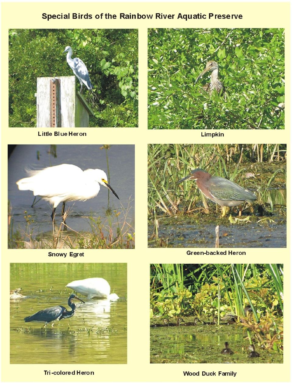
3 our goal is to preserve the open land on the river corridor. This will protect the springs and rivers water quality and also preserve the habitat that supports a vast array of birds, turtles, amphibians and reptiles including endangered or listed species. To accomplish this, it is necessary to consider preserving a group of land parcels. Figure 4 shows a map of the Rainbow River with outlines of the adjacent land parcels. (The base data is from the Marion County Property Appraisers web site.) The parcels highlighted in light green are currently Florida State properties. The properties highlighted in light yellow are those that are being proposed for the Florida Forever program. The red parcels were added to the project in the April 2007 amendment. These candidate parcels have been divided into seven groups. These groups have two things in common. First, acquisition of each group and maintaining the land as open space would have a significant positive affect on preserving the water quality and habitat of the Rainbow River Aquatic Preserve. Second, most of the parcels under consideration, border on existing Florida State land. To add some perspective, a table is included that shows acreage, ownership and footage of riverfront. This data is from the Marion County Property Appraiser database and is subject to review during the Florida Forever evaluation. An aerial map with land use highlights and a topographic map of the river area are also attached for perspective. Each group of property has its own personality. Formal Florida Forever submissions were attached to this Executive Summary for each group with the application. A few highlights will be noted. The Indian Creek group includes four significant springs that have been mapped by the Aquatic Preserve and have been included in the total outflow of Rainbow Springs and the Rainbow River. Limpkin, Little Blue Herons, Tri-colored Herons, Ibis, Wood storks and Snowy Egrets are listed species that feed in the marshes of the Rainbow River. Photos of these birds are included in the attachments. The Rainbow Springs State Park and its campground area along with KP Hole County Park, provide public access to the Rainbow River for low impact use. Citizens of all economic means can enjoy a quiet trip on the river to observe the wonders of nature. Preserving the Rainbow River Corridor should be a high priority of the Florida Forever Program Figure 3 People enjoy floating on inner tubes on a quiet day on the Rainbow River
 The parcels highlighted in light green are currently Florida State properties.")
4 Figure 4 Major land parcels along the Rainbow River Corridor

5 Major Parcels Bordering or Near Rainbow River Dunnellon Florida Parcel Number Acres Riverfront Feet Owner Address Headwater Group SMITH, SANDRA ELLEN, ET AL C/O RENEE STEPHENS, W HWY 40, DUNNELLON FL C/O RENEE STEPHENS, W HWY 40, DUNNELLON FL A SMITH, SANDRA ELLEN, ET AL 2B ALEXANDER ADDIE R FOLKS 1908 NE 7TH PL, OCALA FL C FOLKS, RONALD H 225 SW MADISON CIR N, SAINT PETERSBURG FL ALEXANDER ADDIE R FOLKS 1908 NE 7TH PL, OCALA FL SMITH, SANDRA ELLEN ET AL C/O RENEE STEPHENS, W HWY 40, DUNNELLON FL Indian Creek Group DULEY, JOHN E 8921 SW 190TH AVENUE RD, DUNNELLON FL PRIEST, JOE F 1220 SE 12TH CT, OCALA FL SMITH MARY MANN & MARTHA MANN BUTTNER 2773 SEABREEZE DR S, GULFPORT FL PRIEST, SARA KAY 3920 SE 15TH ST, OCALA FL DULEY JOHN E 8921 SW 190TH AVENUE RD, DUNNELLON FL Meredith Property MEREDITH, JUANITA S & MEREDITH, CARROL S PO BOX 712, DUNNELLON FL Greenberg Group GREENBERG, BERNARD Z PO BOX 248, INDIAN ROCKS BEACH FL A GREENBERG, BERNARD Z PO BOX 248, INDIAN ROCKS BEACH FL GREENBERG BERNARD Z PO BOX 248, INDIAN ROCKS BEACH FL (Split Parcel) GREENBERG BERNARD Z PO BOX 248, INDIAN ROCKS BEACH FL Rainbow River Ranch Group RAINBOW RIVER RANCH LLC 104 W SUPERIOR ST, DULUTH MN RAINBOW RIVER RANCH LLC 105 W SUPERIOR ST, DULUTH MN RAINBOW RIVER RANCH LLC 106 W SUPERIOR ST, DULUTH MN A RAINBOW RIVER RANCH LLC 107 W SUPERIOR ST, DULUTH MN Blue Run of Dunnellon Property

6 BLUE RUN OF DUNNELLON LLC 1040 NE 31ST TER, OCALA FL Rainbow River Club Property NATURE PRESERVES OF AMERICA PO BOX 1778, DUNNELLON FL Totals , (From Property Appraiser Tax Card) Addendum Parcel Number Acres Riverfront Feet Owner Address ROBERTS, KENNETH E 8909 SW 190TH AVENUE RD est. 0 SECRET PROMISE LTD of BEACH DRIVE SE STE 302E, SAINT PETERSBURG FL, A MEREDITH, JUANITA S & MEREDITH, CARROL S PO BOX 712, DUNNELLON FL (Acquisition of complete 63 acres) A MEREDITH, JAMES REID & DAWN E PO BOX 1635, DUNNELLON FL A122 Altkey est Lowry, James R II N Osborne Ave, Dunnellon FL, Citrus County 15, River Frontage from first group Grand Total , Acres Feet

7
8 Rainbow River Corridor Current Land Use

9 Topographical Map of the Rainbow River Area (Source USGS)

10 The preceding pages are a portion of the Executive Summary of the Rainbow River Corridor Project application. This application was submitted in October of 2006 to the Florida Department of Environmental Protection, Division of State Lands, for their Florida Forever Program. The project qualification process is rigorous. Rainbow River Conservation Inc. (RRC) hopes that this project will be placed on a preferential list of lands targeted for acquisition by February of The Acquisition and Restoration Council (ARC), a broad multi-agency council with participation from over 10 state agencies, manages the Florida Forever Program. Criteria for selection include lands that are environmentally sensitive and that impact major water systems and springs. Impact on forest systems and recreation potential are also considered. Funds are limited and numerous candidate projects from all counties in the state compete for these resources. Successful acquisition is consummated between willing buyers and sellers and eminent domain is never a part of this process. Rainbow River Conservation Inc. is a 501.c3 corporation whose mission is to protect and maintain the quality of the water and habitat of the Rainbow River for current and future generations. RRC activities include public advocacy for the river, monitoring water levels and water conditions, managing the annual river cleanup and installing and maintaining 45 Wood Duck boxes along the river. RRC has pursued this mission since the 1960 s and played a key role in advocating for the acquisition of lands to start and expand the Rainbow Springs State Park. The Rainbow River Conservation address is PO Box 729, Dunnellon, FL and the officers are: Burt Eno President Jerry Rogers Vice President Gretchen Martin Treasurer Mary Ann Ermatinger Secretary The Rainbow River is a major natural asset of Marion County, Central Florida and the United States. Public access is available from Rainbow Springs State Park, the State Park Campgrounds, KP Hole County Park and from the Tuber Exit at County Route 484. There are also three community parks that yield access for launching kayaks and canoes. All who visit this river come away with an appreciation of its beauty and its extraordinary range of birds, turtles, fish, and otters. The river must be preserved in its current form to maintain its beauty, water quality and broad range of species.
 hopes that this project will be placed on a preferential list of lands targeted for acquisition by February of 2007.")
Pennsylvania's Clean and Green Program
 Pennsylvania's Clean and Green Program The Penn State Dickinson Agricultural Law Resource and Reference Center * The purpose of this publication is to help you learn about and understand this important
City of Ocala PERMITS ISSUED. For the Period 12/20/2015 thru 12/26/2015
 1 BLD15-0974 2600 SW 42ND ST BLDG 6 135,00 1,182.41 1,182.41 6/30/2015 ADDITION 23942-000-00 4505 TRINITY CATHOLIC HS / BASEBALL LOCKER ROOM OWNER TRINITY CATHOLIC HS APPLICANT FABIAN CONSTRUCTION LLC
The Nature Conservancy Offering Protected Lands for Sale in the Adirondacks Sustainable Forestry to Continue
 News release For immediate release August 21, 2008 Contact: Connie Prickett, (518) 576-2082 x162, [email protected] The Nature Conservancy Offering Protected Lands for Sale in the Adirondacks Sustainable
THE RUSKIN COMMUNITY PLAN
 THE RUSKIN COMMUNITY PLAN Introduction Ruskin is a historic community situated on the shores of Tampa Bay, the Little Manatee River and the Ruskin Inlet, approximately 16 miles southeast of Tampa. The
4. Priority Areas of Conservation
 4. Priority Areas of Conservation A. SIGNIFICANT RESOURCE AREAS This Open Space and Farmland Plan identifies the key issues facing open space and agricultural resources in the Town, highlights the location
Arkansas River Corridor Vision & Master Plan
 A r k a n s a s R I v e r C o r r I d o r P l a n Arkansas River Corridor Vision & Master Plan July 2005 Indian Nations Council of Governments A r k a n s a s R I v e r C o r r I d o r P l a n Partnership
Conservation Tax Credit Regulations Chapter 391-1-6 A-1 RULES OF GEORGIA DEPARTMENT OF NATURAL RESOURCES CHAPTER 391-1-6
 Conservation Tax Credit Regulations Chapter 391-1-6 A-1 RULES OF GEORGIA DEPARTMENT OF NATURAL RESOURCES CHAPTER 391-1-6 GEORGIA CONSERVATION TAX CREDIT PROGRAM TABLE OF CONTENTS 391-1-6-.01 Purpose and
AN INITIATIVE TO IMPROVE
 L OW E R C A R M E L R I V E R A N D L AG O O N F L O O D P L A I N R E S TO R AT I O N A N D E N H A N C E M E N T P R O J E C T AN INITIATIVE TO IMPROVE FLOOD PROTECTION RESTORE AND PROTECT RIPARIAN
Using Aerial Photography to Measure Habitat Changes. Method
 Then and Now Using Aerial Photography to Measure Habitat Changes Method Subject Areas: environmental education, science, social studies Conceptual Framework Topic References: HIIIB, HIIIB1, HIIIB2, HIIIB3,
RP-5217 Real Property Transfer Report Instructions
 RP-5217-INS (Rev. 11/11) RP-5217 Real Property Transfer Report Instructions Data Management Unit (518) 474-1170 Tax and Finance website: www.tax.ny.gov The RP-5217 Real Property Transfer Report is a form
Land Protection Planning for the National Wildlife Refuge System
 March 2012 Planning Information Brochure 1 Land Protection Planning for the National Wildlife Refuge System The following questions are often asked when the U.S. Fish and Wildlife Service (Service) begins
How Your Property Tax Is Determined
 Property Tax Relief for Forest Landowners by Mel Baughman Extension Forester and Program Leader, University of Minnesota, Department of Forest Resources and University of Minnesota Extension, St. Paul,
PUBLIC NOTICE Application for Permit
 PUBLIC NOTICE Application for Permit 30-Day Notice Issue Date: June 20, 2016 Expiration Date: July 20, 2016 US Army Corps of Engineers No: NWP-2010-535 Oregon Department of State Lands No: 58311-RF Interested
Acton Quarry Extension. Halton Region June 11, 2014
 Acton Quarry Extension Halton Region June 11, 2014 1 Background Background Proposed Extraction Area Compliance with Ministry Guidelines Halton Region Official Plan Greenlands System Conveyance of Land
Addendum D. Nomination of Moody Wash ACEC
 Addendum D Nomination of Moody Wash ACEC Moody Wash ACEC is hereby nominated by Citizens for Dixie s Future to: BLM St. George Field Office 345 East Riverside Drive St. George, UT 84790 Moody Wash is a
Trempealeau County Tax & Assessment Search User Manual
 Trempealeau County Tax & Assessment Search User Manual November 17, 2004 Table of Contents Chapter 1 Getting Started Chapter 2 - Search Form Chapter 3 - Search Results Chapter 4 Parcel Property Tax History
Indian River Lagoon National Scenic Byway Coalition Nonprofit Annual Report FY 2013
 Indian River Lagoon National Scenic Byway Coalition Nonprofit Annual Report FY 2013 February 2014 February 2014 Letter from the Chair In the spring of 1999, a group of community advocates including county,
Series 2016A-2 (Green Bonds) Final Proceeds Allocation April 2016
 Final Proceeds Allocation April 2016") Series 2016A-2 (Green Bonds) Final Proceeds Allocation April 2016 James L. McIntire Washington State Treasurer Summary The State of Washington offered green bonds to investors in September 2015, with approximately
Series 2016A-2 (Green Bonds) Final Proceeds Allocation April 2016 James L. McIntire Washington State Treasurer Summary The State of Washington offered green bonds to investors in September 2015, with approximately
SAWTOOTH NATIONAL RECREATION AREA AND JERRY PEAK WILDERNESS ADDITIONS ACT
 PUBLIC LAW 114 46 AUG. 7, 2015 SAWTOOTH NATIONAL RECREATION AREA AND JERRY PEAK WILDERNESS ADDITIONS ACT VerDate Mar 15 2010 13:12 Aug 13, 2015 Jkt 049139 PO 00046 Frm 00001 Fmt 6579 Sfmt 6579 E:\PUBLAW\PUBL046.114
MEMORANDUM OF AGREEMENT Between THE CITY OF BALTIMORE And THE MID-ATLANTIC FEDERAL PARTNERSHIP FOR THE ENVIRONMENT
 MEMORANDUM OF AGREEMENT Between THE CITY OF BALTIMORE And THE MID-ATLANTIC FEDERAL PARTNERSHIP FOR THE ENVIRONMENT The Mid-Atlantic Federal Partnership for the Environment ( MAFPE ) and the City of Baltimore
USA MEDIGAP CPR a product of State of FLORIDA Accountable Alliance/USA Senior Care Network Sorted by County/Specialty
 ALACHUA BREVARD SHANDS HOSPITAL AT THE UNIVERSITY OF FLORIDA WUESTHOFF HOSPITAL 1600 SW ARCHER RD 110 LONGWOOD AVE GAINESVILLE, FL 32610 (352) 265-0111 ROCKLEDGE, FL 32955 (321) 636-2211 WUESTHOFF MEDICAL
U.S. Department of Justice. March 11, 2014
 a Y 3 ;:.~,. AMG/TLP/MEG: 33-12291 Land Acquisition Section P.O. Box 7611 Washington, DC 20044 U.S. Department of Justice Environment and Natural Resources Division Telephone (202) 305-0376 Facsimile (202)
What we build today will create Denver s tomorrow. Signature development projects will strengthen our economy, create jobs and improve neighborhoods.
 Mayor Hancock s Vision for Building a World-Class City What we build today will create Denver s tomorrow. Signature development projects will strengthen our economy, create jobs and improve neighborhoods.
Deepwater Horizon Oil Spill Phase I Early Restoration Plan and Environmental Assessment
 Deepwater Horizon Oil Spill Phase I Early Restoration Plan and Environmental Assessment Prepared by the Deepwater Horizon Natural Resource Trustees from State of Alabama State of Florida State of Louisiana
The Wonderful World of Wetlands BINGO
 The Wonderful World of Wetlands BINGO Time: 10-15 minutes to create Bingo board; 5-10 minutes to play one-round of Bingo Scituate Reservoir Watershed Education Program 17 Smith Ave Greenville, RI 02828
AYAK GUIDE ISLAND STATE PARKS. NEW YORK STATE George E. Pataki, Governor
 AYAK & C KAYAK AYAK & CANOE GUIDE TO LONG ISLAND STATE PARKS NEW YORK STATE George E. Pataki, Governor NEW YORK STATE OFFICE OF PARKS, RECREATION AND HISTORIC PRESERVATION Bernadette Castro, Commissioner
Produced by: Conservation Trust for North Carolina on behalf of. with funding from WalMart
 Produced by: Conservation Trust for North Carolina on behalf of with funding from WalMart 4th Edition 2010 by the Conservation Trust for North Carolina and N.C. Coastal Land Trust 4th Edition Credits:
U.S. Fish and Wildlife Service will invest $15 million for post-sandy cleanup and marsh restoration on Long Island
 For Immediate Release: Wednesday, November 6, 2013 For further information: Michelle Potter, refuge manager, 631/286-0485 ext. 2112, [email protected] Tom Sturm, public affairs specialist, 413/253-8339,
Waterstone Business Park
 Orange County, North Carolina Waterstone Business Park Parcel Size Price Location Zoning Topography Combined total of 47 acres (Parcel #5-22 acres, #7-25 acres) $74,545 per acre (Parcel #5), $32,880 per
I. INTRODUCTION B. A. PURPOSE
 System Plan Introduction A. The Mission of the San Antonio Parks and Recreation Department is to develop and maintain a balanced, safe, and easily accessible system of exceptional parks, recreational facilities
RESTORATION AND ENHANCEMENT OF SOUTHERN CALIFORNIA LAGOONS
 RESTORATION AND ENHANCEMENT OF SOUTHERN CALIFORNIA LAGOONS by Hany Elwany, Ph.D. Scripps Institution of Oceanography Headwaters to Oceans Conference 25 October 2003 CE Ref #03-22 San Diego County Lagoons
San Francisco Bay Area Wetlands Restoration Program Design Review Group. Project Summary Outline
 San Francisco Bay Area Wetlands Restoration Program Design Review Group Project Summary Outline The project proponent desiring to have a project considered by the Design Review Group (DRG) shall provide
USA MEDIGAP CPR a product of State of FLORIDA Accountable Alliance/USA Senior Care Network Sorted by County/Specialty
 ALACHUA BREVARD SHANDS HOSPITAL AT THE UNIVERSITY OF FLORIDA WUESTHOFF HOSPITAL 1600 SW ARCHER RD 110 LONGWOOD AVE GAINESVILLE, FL 32610 (352) 265-0111 ROCKLEDGE, FL 32955 (321) 636-2211 WUESTHOFF MEDICAL
PLAN HOLDERS LIST. Flood Restoration Project Levee Removal and Restoration Bismarck, ND P00501-0012-04. Bid Date: 10:30 a.m., Tuesday, March 26, 2013
 1815 SCHAFER ST STE 301 BISMARCK ND 58501 TEL: 701-221-0530 FAX: 701-221-0531 Email: [email protected] 2321 2 ND AVE W STE 5 WILLISTON ND 58801 TEL: 701-774-3080 FAX: 701-774-3087 Email: [email protected]
King County, Washington Policies and Practice for the Use of Eminent Domain For Flood Risk Reduction
 King County, Washington Policies and Practice for the Use of Eminent Domain For Flood Risk Reduction Introduction Eminent domain refers to the power possessed by the state over all property within the
Fatherhood Programs (county by county list)
") Fatherhood Programs (county by county list) Alachua County 2100 NW 53rd Ave Gainesville, FL 32652 (352) 377 5690 Family Preservation 1731 NW 6th Street. Ste 1 Gainesville, FL 32609 (352) 213 6561 Baker
Fatherhood Programs (county by county list) Alachua County 2100 NW 53rd Ave Gainesville, FL 32652 (352) 377 5690 Family Preservation 1731 NW 6th Street. Ste 1 Gainesville, FL 32609 (352) 213 6561 Baker
BASSETT CREEK VALLEY MASTER PLAN OPEN HOUSE
 BASSETT CREEK VALLEY MASTER PLAN OPEN HOUSE February 23, 2006 PROJECT INTRODUCTION Project Area 230 acres $50 million estimated market value (approximately) 50 acres parkland 100 residences (estimated)
TH 23 Access Management Study Richmond to Paynesville
 TH 23 Access Management Study Richmond to Paynesville Prepared For: Minnesota Department of Transportation District 8 Prepared By: Short Elliott Hendrickson Inc. July 2015 Table of Contents I. Introduction...
U.S. DEPARTMENT OF THE INTERIOR BUREAU OF LAND MANAGEMENT MEDFORD DISTRICT GRANTS PASS FIELD OFFICE 2164 NE Spalding Ave Grants Pass, OR 97526
 A. Background U.S. DEPARTMENT OF THE INTERIOR BUREAU OF LAND MANAGEMENT MEDFORD DISTRICT GRANTS PASS FIELD OFFICE 2164 NE Spalding Ave Grants Pass, OR 97526 Categorical Exclusion Determination and Decision
Sensitive and Priority Areas
 Chapter 3 Sensitive and Priority Areas 3.1 Introduction U.S. EPA and IDEM policy require communities to place a priority on addressing combined sewer overflow (CSO) discharges to sensitive areas. The IDEM
Dear Mr. Lawrence, Thank you for your attention to this matter. Respectfully submitted,
 September 12, 2013 Electronic filing Christopher Lawrence Office of Electricity Delivery and Energy Reliability (OE-20), U.S. Department of Energy, 1000 Independence Avenue, SW. Washington, DC 20585 Fax:
Multiple Species Conservation Program County of San Diego. A Case Study in Environmental Planning & The Economic Value of Open Space
 Multiple Species Conservation Program County of San Diego A Case Study in Environmental Planning & The Economic Value of Open Space Amy M. Fox Land Use Law Case Study Autumn Semester, 1999 Multiple Species
DENSITY AND PUBLIC SPACE AT BISHOP STREET
 DENSITY AND PUBLIC SPACE AT BISHOP STREET Niehoff Urban Studio Senior Planning Capstone Spring 2015 Justin M. Lightfield U N I V E R S I T Y O F C I N C I N N A T I Table of Contents Overview... 3 Design
City of Arnold, Missouri
 City of Arnold, Missouri Business Brochure City of Arnold 2101 Jeffco Blvd. Arnold, MO 63010 Phone: 636-282-2378 Fax: 636-282-6677 E-mail: [email protected] The City of Arnold is a suburban community
Creed James Office: (307)326-3104 Cell: (307)399-7973
326-3104 Cell: (307)399-7973") Presented By: Creed James Office: (307)326-3104 Cell: (307)399-7973 Price: $600,000.00 Features: 900 ft. +/- Frontage on North Platte River, Undeveloped, Power on Property, Water & Sewer Close By Location:
Presented By: Creed James Office: (307)326-3104 Cell: (307)399-7973 Price: $600,000.00 Features: 900 ft. +/- Frontage on North Platte River, Undeveloped, Power on Property, Water & Sewer Close By Location:
Appendix A: Land Protection Plan
 Appendix A: Land Protection Plan In this appendix A.1 Introduction and Purpose A.2 Project Description A.3 Refuge Purposes A.4 Land Acquisition Policy for Urban Refuges A.5 Status of Resources to be Protected
Human Resources Director. City of San Marcos, TX
 Human Resources Director City of San Marcos, TX The Community San Marcos is a thriving, rapidly growing Texas community located on Interstate 35, named recently by Business Week Magazine as one of the
APPENDIX C LIST OF EA RECIPIENTS
 APPENDIX C APPENDIX C LIST OF RECIPIENTS C.1 Federal Agencies Advisory Council on Historic Preservation, Office of Cultural Resources Preservation U.S. Army Corps of Engineers, District Engineer, Regulatory
Minnesota. Company Address Phone/Fax Email/Website Seed Plants Services* www.appliedeco.com [email protected]. 952.447.1919 952.447.
 * Applied Ecological Services, Spring Lake Restoration Nurseries Doug Mensing Office: 21938 Mushtown Road Prior Lake, MN 55372 952.447.1919 952.447.1920 fax www.appliedeco.com [email protected], M,
REZONING 16-000009 & PRELIMINARY PLAT 16-000005
 REZONING 16-000009 & PRELIMINARY PLAT 16-000005 REZONING REQUEST AND REVISED PRELIMINARY PLAT FOR THE BLUFFS AT WINDCASTLE - 4165 FAREDALE LANE Application: Engineer: Developer: Property Owner: Current
The Colorado River Delta
 The Colorado River Delta An Invaluable Resource for People and Wildlife the colorado river delta The Colorado River Delta and its waters support a rich and diverse treasure of plants and animals in an
Rhode Island NRCS received approximately $2.4 million in ARRA funds to implement four floodplain easement projects.
 American Recovery and Reinvestment Act (ARRA) Emergency Watershed Protection Program Floodplain Easements Rhode Island Natural Resources Conservation Service Rhode Island NRCS received approximately $2.4
EXHIBIT A LOCATION MAP AND LAND USE INFORMATION
 EXHIBIT A LOCATION MAP AND LAND USE INFORMATION In accordance with Arizona Corporation Commission Rules of Practice and Procedure R14-3-219, Applicant provides the following location maps and land use
SMART. Babies. Developed by the Drowning Prevention Task Force of Broward County. D r o w n i n g. F o r c e. T a s k. P r e v e n t i o n
 Water SMART Babies Developed by the Drowning Prevention Task Force of Broward County Broward County D r o w n i n g P r e v e n t i o n T a s k F o r c e Message to Parents Welcome The Broward County Drowning
Summary Report for Rookery Bay National Estuarine Research Reserve
 Summary Report for Rookery Bay National Estuarine Research Reserve Contacts: Kevin Cunniff, Rookery Bay National Estuarine Research Reserve Katie Laakkonen, City of Naples Seagrass Integrated Mapping and
Bowmanville Marsh Habitat Restoration and Public Access Project
 Bowmanville Marsh Habitat Restoration and Public Access Project Terms of Reference for Detailed and Conceptual Design Works December 2015 1.0 Background and Purpose The Bowmanville Marsh Habitat Restoration
13. ENVIRONMENTAL PROTECTION/ RESOURCE MANAGEMENT
 13. ENVIRONMENTAL PROTECTION/ RESOURCE MANAGEMENT A. Existing Conditions Ramsey is fortunate to have an ample amount of natural resources and open space areas and a community attitude that is increasingly
3. The submittal shall include a proposed scope of work to confirm the provided project description;
 QIN Shoreline Master Program Project Summary The Shoreline Master Program (SMP) development process for the Quinault Indian Nation (QIN) includes the completion of inventory and analysis report with corresponding
Marketing and Information Department 390 North Orange Ave., Suite 1300 Orlando, FL 32801 407/316-4500 Fax: 407/316-4599 PARTNER INFORMATION
 Marketing and Information Department 390 North Orange Ave., Suite 1300 Orlando, FL 32801 407/316-4500 Fax: 407/316-4599 PARTNER INFORMATION Small Business Administration 7A Loan Guarantee Program How It
Land Specialties is North Georgia s premier development company for mountain lifestyle communities. Whether you imagine life on the lake, the links,
 Land Specialties is North Georgia s premier development company for mountain lifestyle communities. Whether you imagine life on the lake, the links, or the lofty peaks, we bring your vision into clear
RED-TAIL CONSERVANCY ANNUAL REPORT 2005
 RED-TAIL CONSERVANCY ANNUAL REPORT 2005 Goose Nest on Cabin Creek :: Yuhas Woods Prepared by Barry Banks, Executive Director RED-TAIL CONSERVANCY ANNUAL REPORT May, 2005 Overview It is with great satisfaction
3 September 9, 2015 Public Hearing
 3 September 9, 2015 Public Hearing APPLICANT: PI TELECOM INFRASTRUCTURE T, LLC PROPERTY OWNER: JSW HOLDINGS, LLC STAFF PLANNER: Carolyn A.K. Smith REQUEST: Conditional Use Permit (communications tower-monopole)
Conducting a Land Use Inventory
 Chapter 3 Conducting a Land Use Inventory Included in this chapter: Determining Current Land Use Conditions Preparing a Base Map Deciding on Land Use Categories Collecting Current Land Use Data Preparing
Leveraging Ohio s Clean Water SRF Program to Fund Stream and Wetland Restoration and Protection Projects
 Leveraging Ohio s Clean Water SRF Program to Fund Stream and Wetland Restoration and Protection Projects Association of State Wetland Managers 2014 State/Tribal/Federal Coordination Meeting Shepherdstown,
FORMULA FOR FINDING THE SQUARE FEET OF A RECTANGLE L x W = A
 UNIT I REAL ESTATE MATH AREA MEASUREMENTS FORMULA FOR FINDING THE SQUARE FEET OF A RECTANGLE L x W = A Where: A = Area L = Length W = Width If the length = 30 and the width = 20 20 x 30 = 600 Sq. Feet
PROPERTY TAX RELIEF PROGRAMS
 PROPERTY TAX RELIEF PROGRAMS S.L. 2009-574 Studies Bill Revenue Laws Study Committee authorized to study issues relating to the effects on local units of government of enacted property tax relief programs
SECTION 9 SUMMARY OF COORDINATION, PUBLIC VIEWS AND COMMENTS
 SECTION 9 SUMMARY OF COORDINATION, PUBLIC VIEWS AND COMMENTS This page intentionally left blank. 9.0SUMMARY OF COORDINATION, PUBLIC VIEWS AND COMMENTS 9.1 PUBLIC OUTREACH AND PUBLIC INVOLVEMENT Public
Land Use and Zoning. Land Use Within the Port Madison Indian Reservation
 Land Use and Zoning Land Use Within the Port Madison Indian Reservation A portion of the Suquamish Rural Village is Trust land, owned either by the Tribe or individual tribal members. The following list
License Expiration Date
 Florida Licensed Private Adoption Agencies Contact: Tisha M. Pierre, Statewide Licensing Specialist [email protected] (850) 228-9984 Provider ID License Expiration Date Updated December 2015
CITY OF ROANOKE AND TOWN OF VINTON, VIRGINIA. RSTP Funds Joint Application FOR
 CITY OF ROANOKE AND TOWN OF VINTON, VIRGINIA RSTP Funds Joint Application FOR Tinker Creek Pedestrian Bridge: Tinker Creek and Glade Creek Greenways Connection Date: September 15, 2014 RSTP Project Profile
How To Plan A Buffer Zone
 Backyard Buffers Protecting Habitat and Water Quality What is a buffer? A buffer (also called a riparian buffer area or zone) is the strip of natural vegetation along the bank of a stream, lake or other
Laramie River Acreage
 Laramie River Acreage Presented By: Creed James Office: (307)326-3104 Cell: (307)399-7973 Laramie River Acreage Price: $225,000.00 Features: 400 ft. of frontage on Laramie River, Great Building sites,
CITY OF POMPANO BEACH ADVISORY BOARDS AND COMMITTEES
 CITY OF POMPANO BEACH ADVISORY BOARDS AND COMMITTEES BOARDS/COMMITTEES ESTABLISHED BY SECRETARY/CONTACT Affordable Housing Advisory Committee Ord. No. 93-56 & 08-50 JoAnn Martin-Onesky 786-4657 Air Park
Easements to Protect Historic Properties: A Useful Historic Preservation Tool with Potential Tax Benefits
 Easements to Protect Historic Properties: A Useful Historic Preservation Tool with Potential Tax Benefits National Park Service Technical Preservation Services 2010 What is a Historic Preservation Easement?
CHAD R. GOURLEY SPECIALTY EMPLOYMENT
 CHAD R. GOURLEY P.O. Box 919 Verdi, Nevada 89439 phone 775.345.9960 cell 775.250.8140 chad_gourley at att.net SPECIALTY Restoration of riverine, spring, and wetland ecosystems, specializing in a process
Case No.: A-9955-C COUNTY COUNCIL OF PRINCE GEORGE'S COUNTY, MARYLAND, SITTING AS THE DISTRICT COUNCIL ZONING ORDINANCE NO. 5-2005
 Case No.: A-9955-C Applicant: Florida on the Potomac, LLC COUNTY COUNCIL OF PRINCE GEORGE'S COUNTY, MARYLAND, SITTING AS THE DISTRICT COUNCIL ZONING ORDINANCE NO. 5-2005 AN ORDINANCE to amend the Zoning
March 2008. Prepared by: Irvine Ranch Water District. 15600 Sand Canyon Avenue. Irvine, CA 92618. Contact: Natalie Likens (949) 453-5633
 453-5633") ADDENDUM TO THE MICHELSON WATER RECLAMATION PLANT PHASE 2 & 3 CAPACITY EXPANSION PROJECT FEBRUARY 2006 FINAL ENVIRONMENTAL IMPACT REPORT AND THE SAN JOAQUIN FRESHWATER MARSH ENHANCEMENT PLAN REVISED SEPTEMBER
ADDENDUM TO THE MICHELSON WATER RECLAMATION PLANT PHASE 2 & 3 CAPACITY EXPANSION PROJECT FEBRUARY 2006 FINAL ENVIRONMENTAL IMPACT REPORT AND THE SAN JOAQUIN FRESHWATER MARSH ENHANCEMENT PLAN REVISED SEPTEMBER
CONSERVATION IN AMERICA: State Government Incentives for Habitat Conservation. A Status Report.
 CONSERVATION IN AMERICA: State Government Incentives for Habitat Conservation. A Status Report. By Susan George, Defenders of Wildlife. March 2002. STATE PROFILES Numerous examples abound of landowner
Briefing Paper on Lower Galveston Bay and Bayou Watersheds Lower Bay I: Armand Bayou to Moses Lake and Adjacent Bay Waters
 Briefing Paper on Lower Galveston Bay and Bayou Watersheds Lower Bay I: Armand Bayou to Moses Lake and Adjacent Bay Waters Jim Lester, PhD. and Lisa Gonzalez Houston Advanced Research Center Galveston
Baytowne Shoppes Corner Lot Champaign, IL
 Champaign, IL For Sale $345,000 Offering Highlights Outstanding Corner Lot Ready For Development High Traffic Location/Great Visibility Alex Ruggieri, CCIM, MBA Senior Advisor 217.398.1111 [email protected]
Peninsular Florida Landscape Conservation Cooperative. Charter. Background
 Charter Background The Peninsular Florida Landscape Conservation Cooperative (Conservation Cooperative) is part of a national network of Landscape Conservation Cooperatives (LCCs). LCCs are applied conservation
Mastering U.S. LEGAL DESCRIPTIONS
 www.landtraining.net Mastering U.S. LEGAL DESCRIPTIONS This FREE Webinar is offered by Midland College in collaboration with Alyce Hoge of Land Training. Alyce Hoge is the instructor for the Midland College