CityGML goes to Broadway
|
|
|
- Jared Thompson
- 9 years ago
- Views:
Transcription
1 CityGML goes to Broadway Thomas H. Kolbe, Barbara Burger, Berit Cantzler Chair of Geoinformatics September 11, 2015 Photogrammetric Week 2015, Stuttgart The New York City Open Data Portal Data is provided by different departments of NYC administration; most datasets are regularly updated free use of datasets, but NYC remains owner Many 2D and 2.5D geospatial datasets are available e. g. building footprints, road centerlines, land parcels, water bodies raster based DTM with 1 ft. resolution land cover classification map Thematic data on value assessments, ownerships etc. But: no 3D data; no uniform coordinate reference system; no common feature definition or exchange format T. H. Kolbe CityGML goes to Broadway 2

2 City Geography Markup Language CityGML Application independent Geospatial Information Model for semantic 3D city and landscape models comprises different thematic areas (buildings, vegetation, water, terrain, traffic, tunnels, bridges etc.) Internat l Standard of the Open Geospatial Consortium V1.0.0 adopted in 08/2008; V2.0.0 adopted in 3/2012 Data model (UML) + Exchange format (based on GML3) CityGML represents 3D geometry, 3D topology, semantics, and appearance in 5 discrete scales (Levels of Detail, LOD) T. H. Kolbe CityGML goes to Broadway 3 3D Decomposition of Urban Space in CityGML City is decomposed into meaningful objects with clear semantics and defined spatial and thematic properties buildings, roads, railways, terrain, water bodies, vegetation, bridges buildings may be further decomposed into different storeys (and even more detailed into apartments and single rooms) application specific data are associated with the different objects Image: Paul Cote, Harvard Graduate School of Design T. H. Kolbe CityGML goes to Broadway 4

3 Semantic 3D City Model as Integration Platform T. H. Kolbe CityGML goes to Broadway 5 (Inter)national Usage / Availability of CityGML Cities / Municipalities e.g. almost all German cities with 3D city models; Rotterdam, Zürich, Geneva, Paris, Marseille, Helsinki, Istanbul, Vancouver, Montreal, Kuala Lumpur, Yokohama, Singapore, Abu Dhabi, and many more; however, few implementations in the USA so far Organisations e.g. IGN France, Ordnance Survey, all 16 State Mapping Agencies of Germany, BIMTAS in Istanbul, many companies, research institutes, and universities CityGML is reference model in the European INSPIRE initiative ( full EU coverage) INSPIRE building model is based on CityGML The official national and municipal 3D geoinformation standards of Germany, The Netherlands base on CityGML T. H. Kolbe CityGML goes to Broadway 6

4 Employed Data Sets from NYC Open Data Legend Land (783 km 2 ) Water (297 km 2 ) DTM Bounding Box Feature type Input datasets Dept. Addresses NYC Address Points DoITT Buildings DTM Building Footprints MapPLUTO 1 ft. Digital Elevation Model (DEM) DoITT DTM DEP & DoITT Lots MapPLUTO DTM Parks Mèmèkas Meadow Parks Properties DoITT DPR Streets LION Geodatabase DCP Trees Street Tree Census DPR N km Waterbodies Hydrography Waterbody Structures Zoning Hydrographystructures Zip Code Boundaries Census Tracts 2010 Borough Boundaries DoITT DoITT DoITT DCP DCP T. H. Kolbe CityGML goes to Broadway 7 Challenges in the Generation of the 3D City Model only 2D and 2.5D data given generation of 3D geometries volumetric building and tree models all other feature types mapped onto the terrain special treatment of road geometries to include different height levels data heterogeneity different coordinate reference systems different exchange formats (Shapefiles, ESRI GeoDB, Excel etc.) no standardized semantic data model / ontology (each department defines their own data structures) 1:1, 1:n, and n:m mappings required huge data volume large area with > 1 million buildings; big DTM; in total about 4 million objects T. H. Kolbe CityGML goes to Broadway 8

5 Processing Workflow and Employed Tools Implementation is based on 3DCityDB (Open Source) running on Oracle Spatial Feature Manipulation Engine (FME) 24 different workspaces 3DCityDB Webclient (Open Source) based on Cesium Virtual Globe or Google Earth T. H. Kolbe CityGML goes to Broadway 9 Digital Terrain Model (DTM) A DTM with 1 ft. resolution is given in the Open Data Portal one large image file of 140 GB Initial processing steps: resampling to 1m resolution reprojection to the compound 2D+1D coordinate reference system NAD83 New York State Planes, Long Island, Meter (horizontal), NAVD88 height, Meter (vertical) Generation of tiles with 250m x 250m extent determination of a 3D boundary ring for each tile; this ring fixes the height profile along the four tile borders (C0 continuity only) constrained triangulation (boundary rings used as break lines) generation of CityGML ReliefFeature objects import into the 3DCityDB geodatabase T. H. Kolbe CityGML goes to Broadway 10
, NAVD88 height, Meter (vertical) Generation of tiles with 250m x 250m extent determination of a 3D boundary ring for each tile; this ring fixes")
6 DTM Tiling Seamless Border Transitions a DTM tile Result: 35,153 tiles of 250m x 250m in CityGML T. H. Kolbe CityGML goes to Broadway 11 3D Building Models w/o DTM with DTM 2D building footprints come with a building height (in ft.) a number of thematic attributes building identification number generation of 3D solids by extrusion (CityGML LOD 1) adjustment of the base heights according to the DTM integration of address data integration of MAPPLUTO data T. H. Kolbe CityGML goes to Broadway 12

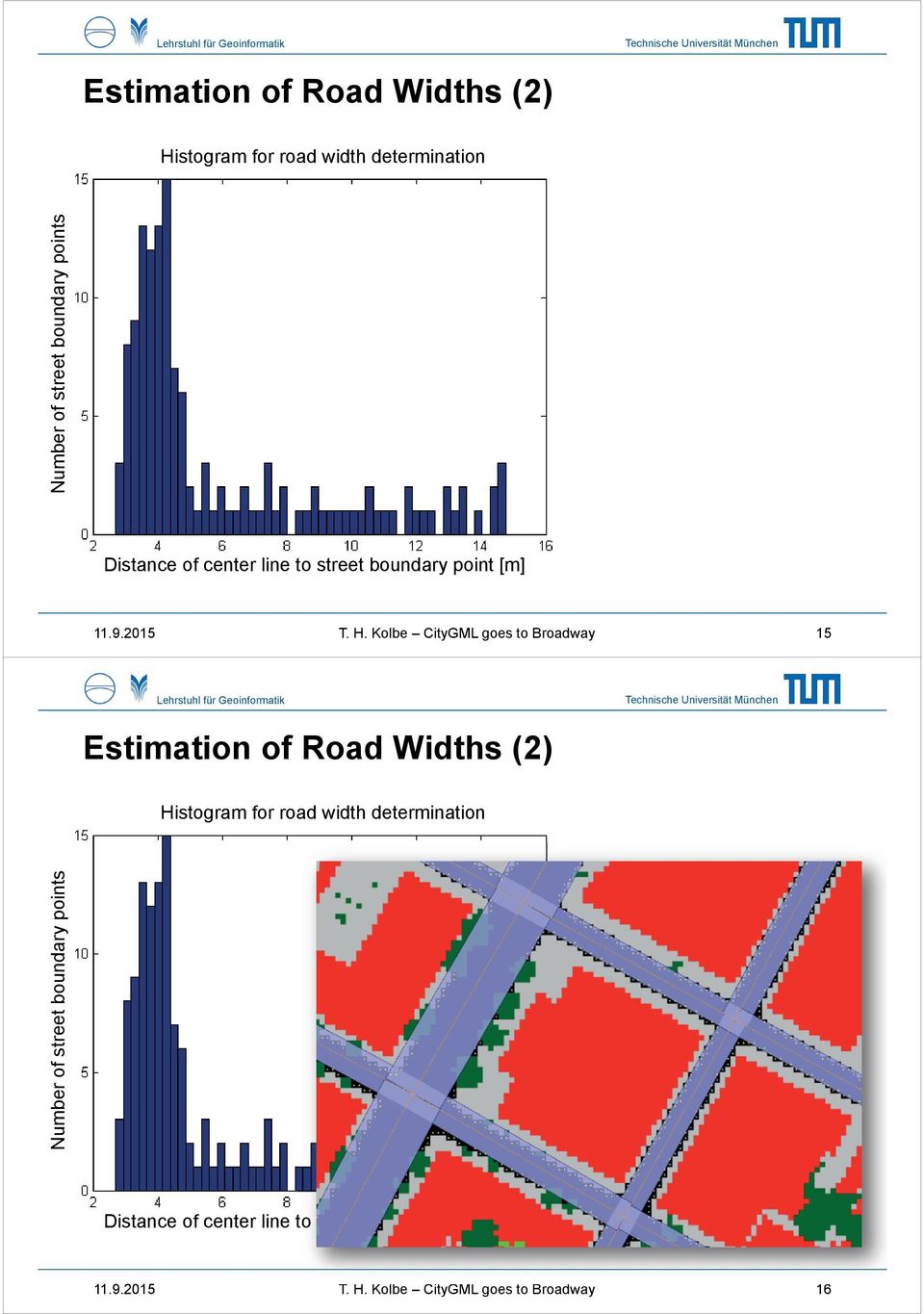
7 3D Road Models Usable data from the NYC Open Data Portal: LION file geodatabase with 2D road center lines (vector data with thematic attributes like road name, traffic directions, snow removal priority etc.) land cover classification map (raster data) CityGML represents roads spatially in LOD 0 as a 3D geometric complex / graph with embedding in 3D in LOD 1 by the street surfaces road widths required! 3D road generation process: determination of road widths for each road segment mapping of center lines and road polygons onto the DTM further height corrections according to qualitative height levels (in order to map elevated roads and complex motorway junctions) T. H. Kolbe CityGML goes to Broadway 13 Estimation of Road Widths (1) road centerlines (orange) overlaid onto the land cover classification map identification of crossings areas have to be excluded from road with estimation for each individual segment determination of the distances from the center line to the first cell not classified as road accumulation of distances in a histogram selection of the mostly occuring width; buffering of the line T. H. Kolbe CityGML goes to Broadway 14

8 Estimation of Road Widths (2) Histogram for road width determination Number of street boundary points Distance of center line to street boundary point [m] T. H. Kolbe CityGML goes to Broadway 15 Estimation of Road Widths (2) Histogram for road width determination Number of street boundary points Distance of center line to street boundary point [m] T. H. Kolbe CityGML goes to Broadway 16
9 Generated 3D Street Geometries (2) Complex motorway junction with many different height levels 3D embedded graph usable for routing applications has been created T. H. Kolbe CityGML goes to Broadway 17 Generated CityGML Objects for NYC (1) Dataset Format Geometry types Number of Num of Data size objects attributes [GB] Buildings/ Shape 2D polygon/point 2,023, Addresses CityGML 3D Solid 2,020, DTM Raster Grid CityGML Tiled TIN 35,153 tiles 1,450 Land Cover Raster Grid CityGML Lots Shape 2D Polygon 857, CityGML 3D Polygon 866, Parks Shape 2D Polygon 14, CityGML 3D Polygon 16, Streets ESRI File gdb 2D Line 212, CityGML 3D Line+Polygon 149, Street Inter- ESRI File gdb 2D Point 125, sections CityGML 3D Point 104, T. H. Kolbe CityGML goes to Broadway 18

10 Generated CityGML Objects for NYC (2) Dataset Format Geometry types Number of Num of Data size objects attributes [GB] Trees Shape 2D Point 623, CityGML 3D tree shape solid 277, Water Shape 2D Polygon 1, Bodies CityGML 3D Polygon 9, Water Body Shape 2D Polygon 2, Structures CityGML 3D Polygon 2, Zoning Shape 2D Polygon 2, CityGML CityObjectGroups 2, Total Original 2D + 2.5D 3,864, CityGML 3D + 2.5D 3,484,284 1,583.7 The largest share (1.45 TB) is required by the DTM, due to the XML representation of > 5 billion triangles File compression reduces CityGML files to 5% of their original size. The compressed NYC dataset has 79 GB T. H. Kolbe CityGML goes to Broadway 19 Result: New York City in CityGML LOD 0&1 > 1,000,000 buildings > 866,000 land lots > 149,000 streets > 16,000 parks > 9,500 water bodies > DTM with 1m resolution fully-automatically generated from the 2D geodata published in the NYC Open Data Portal semantic and geometric transformations all objects have 3D geometry rich semantic information (5-75 attributes per object resulting from combining different NYC datasets) integrated within 1 dataset! The 3D CityGML model is Open Data! Download: T. H. Kolbe CityGML goes to Broadway 20
 is required by the DTM, due to the XML representation of > 5 billion triangles File compression reduces CityGML files to 5% of their original size.")
11 Interactive 3D Visualization & Data Inspection Using the Open Source 3DCityDB + the new Webclient & T. H. Kolbe CityGML goes to Broadway 21 Summary A semantic 3D city model for New York City has been generated exclusively based on 2D/2.5D data from NYC Open Data (to the best of our knowledge) this is the first Open Data 3D City Model based on official city data for a large city in the USA Information integration from 26 different datasets into one common and standardized representation (CityGML) DTM, buildings, roads, land parcels, parks, water bodies, water body infrastructures, trees, zoning all objects have rich thematic attributes projection into one common, metric compound 3D CRS Interactive exploration of the 3D city model using our Open Source 3DCityDB Webclient T. H. Kolbe CityGML goes to Broadway 22
 DTM, buildings, roads, land parcels, parks, water bodies, water body infrastructures, trees, zoning all objects have rich thematic")
12 Original T. H. Kolbe image CC-BY-SA-3.0/Matt CityGML goes to Broadway H. Wade at Wikipedia 23

A CityGML-based encoding for the INSPIRE Data Specification on Buildings
 A CityGML-based encoding for the INSPIRE Data Specification on Buildings Gerhard Gröger 1, Tatjana Kutzner 2, Thomas H. Kolbe 2 1 Institute for Geodesy and Geoinformation, University of Bonn 2 Chair of
Introduction to GIS (Basics, Data, Analysis) & Case Studies. 13 th May 2004. Content. What is GIS?
 & Case Studies. 13 th May 2004. Content. What is GIS?") Introduction to GIS (Basics, Data, Analysis) & Case Studies 13 th May 2004 Content Introduction to GIS Data concepts Data input Analysis Applications selected examples What is GIS? Geographic Information
Introduction to GIS (Basics, Data, Analysis) & Case Studies 13 th May 2004 Content Introduction to GIS Data concepts Data input Analysis Applications selected examples What is GIS? Geographic Information
A Method Using ArcMap to Create a Hydrologically conditioned Digital Elevation Model
 A Method Using ArcMap to Create a Hydrologically conditioned Digital Elevation Model High resolution topography derived from LiDAR data is becoming more readily available. This new data source of topography
3D Data Management From Point Cloud to City Model GeoSmart Africa 2016, Cape Town
 3D Data Management From Point Cloud to City Model GeoSmart Africa 2016, Cape Town Albert Godfrind Spatial Solutions Architect ORACLE Corporation April 13, 2016 Copyright 2014 Oracle and/or its affiliates.
GIS Databases With focused on ArcSDE
 Linköpings universitet / IDA / Div. for human-centered systems GIS Databases With focused on ArcSDE Imad Abugessaisa [email protected] 20071004 1 GIS and SDBMS Geographical data is spatial data whose
Publishing Hosted 3D Feature Layers. An Esri White Paper September 2015
 An Esri White Paper September 2015 Copyright 2015 Esri All rights reserved. Printed in the United States of America. The information contained in this document is the exclusive property of Esri. This work
GIS Data in ArcGIS. Pay Attention to Data!!!
 GIS Data in ArcGIS Pay Attention to Data!!! 1 GIS Data Models Vector Points, lines, polygons, multi-part, multi-patch Composite & secondary features Regions, dynamic segmentation (routes) Raster Grids,
CITY OF SUFFOLK, VIRGINIA GIS DATA DISTRIBUTION AND PRICING POLICY
 CITY OF SUFFOLK, VIRGINIA GIS DATA DISTRIBUTION AND PRICING POLICY 1 The City of Suffolk has invested a large amount of effort into the development of a Citywide Geographic Information System (GIS). The
A GIS helps you answer questions and solve problems by looking at your data in a way that is quickly understood and easily shared.
 A Geographic Information System (GIS) integrates hardware, software, and data for capturing, managing, analyzing, and displaying all forms of geographically referenced information. GIS allows us to view,
3D Model of the City Using LiDAR and Visualization of Flood in Three-Dimension
 3D Model of the City Using LiDAR and Visualization of Flood in Three-Dimension R.Queen Suraajini, Department of Civil Engineering, College of Engineering Guindy, Anna University, India, [email protected]
TOWARDS AN AUTOMATED HEALING OF 3D URBAN MODELS
 TOWARDS AN AUTOMATED HEALING OF 3D URBAN MODELS J. Bogdahn a, V. Coors b a University of Strathclyde, Dept. of Electronic and Electrical Engineering, 16 Richmond Street, Glasgow G1 1XQ UK - [email protected]
Technology Trends In Geoinformation
 Technology Trends In Geoinformation Dato Prof. Sr Dr. Abdul Kadir Bin Taib Department of Survey and Mapping Malaysia (JUPEM) Email: [email protected] www.jupem.gov.my NGIS 2008 3 rd. National GIS Conference
<Insert Picture Here> Data Management Innovations for Massive Point Cloud, DEM, and 3D Vector Databases
 Data Management Innovations for Massive Point Cloud, DEM, and 3D Vector Databases Xavier Lopez, Director, Product Management 3D Data Management Technology Drivers: Challenges & Benefits
INTRODUCTION TO ARCGIS SOFTWARE
 INTRODUCTION TO ARCGIS SOFTWARE I. History of Software Development a. Developer ESRI - Environmental Systems Research Institute, Inc., in 1969 as a privately held consulting firm that specialized in landuse
Digital Terrain Model Grid Width 10 m DGM10
 Digital Terrain Model Grid Width 10 m Status of documentation: 23.02.2015 Seite 1 Contents page 1 Overview of dataset 3 2 Description of the dataset contents 4 3 Data volume 4 4 Description of the data
Applying GIS in seismic hazard assessment and data integration for disaster management
 Applying GIS in seismic hazard assessment and data integration for disaster management Rumiana Vatseva, Dimcho Solakov, Emilia Tcherkezova, Stela Simeonova, Petya Trifonova National Institute of Geophysics,
Create a folder on your network drive called DEM. This is where data for the first part of this lesson will be stored.
 In this lesson you will create a Digital Elevation Model (DEM). A DEM is a gridded array of elevations. In its raw form it is an ASCII, or text, file. First, you will interpolate elevations on a topographic
LIDAR and Digital Elevation Data
 LIDAR and Digital Elevation Data Light Detection and Ranging (LIDAR) is being used by the North Carolina Floodplain Mapping Program to generate digital elevation data. These highly accurate topographic
GEOGRAPHIC INFORMATION SYSTEMS CERTIFICATION
 GEOGRAPHIC INFORMATION SYSTEMS CERTIFICATION GIS Syllabus - Version 1.2 January 2007 Copyright AICA-CEPIS 2009 1 Version 1 January 2007 GIS Certification Programme 1. Target The GIS certification is aimed
ArcGIS Data Models Practical Templates for Implementing GIS Projects
 ArcGIS Data Models Practical Templates for Implementing GIS Projects GIS Database Design According to C.J. Date (1995), database design deals with the logical representation of data in a database. The
GIS Spatial Data Standards
 GIS Spatial Data Standards Manatee County, FL GIS Section, Information Services Department TABLE OF CONTENTS I. Introduction 2 A. Purpose 2 B. Reference 2 II. Spatial Reference Information 2 A. Projection:
Creating a File Geodatabase
 Creating a File Geodatabase Updated by Thomas Stieve January 06, 2012 This exercise demonstrates how to create a file geodatabase in ArcGIS 10; how to import existing data into the geodatabase, and how
GIS Initiative: Developing an atmospheric data model for GIS. Olga Wilhelmi (ESIG), Jennifer Boehnert (RAP/ESIG) and Terri Betancourt (RAP)
, Jennifer Boehnert (RAP/ESIG) and Terri Betancourt (RAP)") GIS Initiative: Developing an atmospheric data model for GIS Olga Wilhelmi (ESIG), Jennifer Boehnert (RAP/ESIG) and Terri Betancourt (RAP) Unidata seminar August 30, 2004 Presentation Outline Overview
GIS Initiative: Developing an atmospheric data model for GIS Olga Wilhelmi (ESIG), Jennifer Boehnert (RAP/ESIG) and Terri Betancourt (RAP) Unidata seminar August 30, 2004 Presentation Outline Overview
Databases for 3D Data Management: From Point Cloud to City Model
 Databases for 3D Data Management: From Point Cloud to City Model Xavier Lopez, Ph.D. Senior Director, Spatial and Graph Technologies Oracle Program Agenda Approach: Spatially-enable the Enterprise Oracle
Understanding Raster Data
 Introduction The following document is intended to provide a basic understanding of raster data. Raster data layers (commonly referred to as grids) are the essential data layers used in all tools developed
Request for Proposals for Topographic Mapping. Issued by: Teton County GIS and Teton County Engineering Teton County, Wyoming
 Request for Proposals for Topographic Mapping Issued by: Teton County GIS and Teton County Engineering Teton County, Wyoming Proposals due: 2:00PM MDT July 1, 2015 Proposals may be delivered to: Teton
Government 98dn Mapping Social and Environmental Space
 Government 98dn Mapping Social and Environmental Space LAB EXERCISE 5: The Analysis of Fields Objectives of this lab: Visualizing raster data Using Spatial Analyst functions to create new data Analysis
GIS Data Quality and Evaluation. Tomislav Sapic GIS Technologist Faculty of Natural Resources Management Lakehead University
 GIS Data Quality and Evaluation Tomislav Sapic GIS Technologist Faculty of Natural Resources Management Lakehead University The quality of GIS data gains in importance when considering some of the main
Cookbook 23 September 2013 GIS Analysis Part 1 - A GIS is NOT a Map!
 Cookbook 23 September 2013 GIS Analysis Part 1 - A GIS is NOT a Map! Overview 1. A GIS is NOT a Map! 2. How does a GIS handle its data? Data Formats! GARP 0344 (Fall 2013) Page 1 Dr. Carsten Braun 1) A
Digital Cadastral Maps in Land Information Systems
 LIBER QUARTERLY, ISSN 1435-5205 LIBER 1999. All rights reserved K.G. Saur, Munich. Printed in Germany Digital Cadastral Maps in Land Information Systems by PIOTR CICHOCINSKI ABSTRACT This paper presents
DATA INTEGRATION FROM DIFFERENT SOURCES TO CREATE 3D VIRTUAL MODEL
 DATA INTEGRATION FROM DIFFERENT SOURCES TO CREATE 3D VIRTUAL MODEL A. Erving, P. Rönnholm, and M. Nuikka Institute of Photogrammetry and Remote Sensing, Department of Surveying, Helsinki University of
Statewide 3D SDI with CityGML in North Rhine-Westphalia
 Statewide in North Rhine-Westphalia Institute of Geodesy and Geoinformation Department of Geoinformation University of Bonn OGC Interoperabilityday, 3.6.2008 Statewide Web Services & CityGML State roads
A Web services solution for Work Management Operations. Venu Kanaparthy Dr. Charles O Hara, Ph. D. Abstract
 A Web services solution for Work Management Operations Venu Kanaparthy Dr. Charles O Hara, Ph. D Abstract The GeoResources Institute at Mississippi State University is leveraging Spatial Technologies and
3D Point Cloud Analytics for Updating 3D City Models
 3D Point Cloud Analytics for Updating 3D City Models Rico Richter 25 th May 2015 INSPIRE - Geospatial World Forum 2015 Background Hasso Plattner Institute (HPI): Computer Graphics Systems group of Prof.
DATA VISUALIZATION GABRIEL PARODI STUDY MATERIAL: PRINCIPLES OF GEOGRAPHIC INFORMATION SYSTEMS AN INTRODUCTORY TEXTBOOK CHAPTER 7
 DATA VISUALIZATION GABRIEL PARODI STUDY MATERIAL: PRINCIPLES OF GEOGRAPHIC INFORMATION SYSTEMS AN INTRODUCTORY TEXTBOOK CHAPTER 7 Contents GIS and maps The visualization process Visualization and strategies
UPDATED GIS DATABASE DESIGN: Geodatabase Model
 CITY OF SUFFOLK, VIRGINIA UPDATED GIS DATABASE DESIGN: Geodatabase Model Prepared by: Michael Baker Jr., Inc. Virginia Beach, Virginia TABLE OF CONTENTS A. GEODATABASE OVERVIEW...2 B. TYPES OF GEODATABASES...3
Earth Data Science in The Era of Big Data and Compute
 Earth Data Science in The Era of Big Data and Compute E. Lynn Usery U.S. Geological Survey [email protected] http://cegis.usgs.gov U.S. Department of the Interior U.S. Geological Survey Board on Earth Sciences
Advanced Image Management using the Mosaic Dataset
 Esri International User Conference San Diego, California Technical Workshops July 25, 2012 Advanced Image Management using the Mosaic Dataset Vinay Viswambharan, Mike Muller Agenda ArcGIS Image Management
Geographic Information System Product Distribution Policies. Preface
 Support Services Department Information Technologies Division Geographic Information System Product Distribution Policies Preface 1. Purpose Geographic Information System (GIS) Product Distribution Policies
Implementing Geospatial Data in Parametric Environment Elçin ERTUĞRUL*
 Proceedings of the International Association for Shell and Spatial Structures (IASS) Symposium 2015, Amsterdam 17-20 August 2015, Amsterdam, The Netherlands Implementing Geospatial Data in Parametric Environment
Raster Data Structures
 Raster Data Structures Tessellation of Geographical Space Geographical space can be tessellated into sets of connected discrete units, which completely cover a flat surface. The units can be in any reasonable
Working with Digital Elevation Models and Digital Terrain Models in ArcMap 9
 Working with Digital Elevation Models and Digital Terrain Models in ArcMap 9 1 TABLE OF CONTENTS INTRODUCTION...3 WORKING WITH DIGITAL TERRAIN MODEL (DTM) DATA FROM NRVIS, CITY OF KITCHENER, AND CITY OF
New York City Neighborhood Tabulation Areas
 Page 1 of 10 New York City Neighborhood Tabulation Areas ESRI Shapefile Tags New York, boundary, neighborhoods, Manhattan, projection areas, Queens, Brooklyn, Richmond, boundaries, neighborhood names,
Bentley ArcGIS. Connector
 Bentley ArcGIS Connector Introduction ESRI, as a GIS software products company, and Bentley Systems, Incorporated, as a developer of solutions for architecture/engineering/construction (AEC) professionals,
Generation of a National Virtual 3D City and Landscape Model for the Netherlands
 Generation of a National Virtual 3D City and Landscape Model for the Netherlands Dr. Sander Oude Elberink (U Twente), Dr. Jantien Stoter (TU Delft, Kadaster, Geonovum), Dr. Hugo Ledoux (TU Delft), Ir.
Tutorial 8 Raster Data Analysis
 Objectives Tutorial 8 Raster Data Analysis This tutorial is designed to introduce you to a basic set of raster-based analyses including: 1. Displaying Digital Elevation Model (DEM) 2. Slope calculations
(Geo)database and Data Management
database and Data Management") (Geo)database and Data Management An introduction to the possibilities of a centralized (spatial) data storing and access as well as its data management constraints (GLOWA Volta Project) GLOWA Volta Project
(Geo)database and Data Management An introduction to the possibilities of a centralized (spatial) data storing and access as well as its data management constraints (GLOWA Volta Project) GLOWA Volta Project
massive aerial LiDAR point clouds
 Visualization, storage, analysis and distribution of massive aerial LiDAR point clouds Gerwin de Haan and Hugo Ledoux Data Visualization group GIS technology group GeoWeb 2010, Vancouver July 28 2010 1
Big Data and Analytics: Getting Started with ArcGIS. Mike Park Erik Hoel
 Big Data and Analytics: Getting Started with ArcGIS Mike Park Erik Hoel Agenda Overview of big data Distributed computation User experience Data management Big data What is it? Big Data is a loosely defined
Cadastre in the context of SDI and INSPIRE
 Cadastre in the context of SDI and INSPIRE Dr. Markus Seifert Bavarian Administration for Surveying and Cadastre Cadastre in the digital age the approach in Germany 3 rd CLGE Conference, Hanover, 11.10.2012
technical notes trimble realworks software
 technical notes trimble realworks software A POWERFUL 3D LASER SCANNING OFFICE SOFTWARE SUITE Designed for today s multifaceted scanning professional, Trimble RealWorks is a powerful office software that
GIS a Tool for Transportation Infrastructure Planning in Ghana A Case Study to the Department of Feeder Roads
 GIS a Tool for Transportation Infrastructure Planning in Ghana A Case Study to the Department of Stephen Yao FIATORNU, Ghana Key words: SUMMARY With the development of GIS technology, network transportation
Lesson 15 - Fill Cells Plugin
 15.1 Lesson 15 - Fill Cells Plugin This lesson presents the functionalities of the Fill Cells plugin. Fill Cells plugin allows the calculation of attribute values of tables associated with cell type layers.
Trimble Realworks Software
 TECHNICAL NOTES Trimble Realworks Software A Powerful 3D Laser Scanning Office Software Suite DESIGNED FOR TODAY S MULTIFACETED SCANNING PROFESSIONAL, TRIMBLE REALWORKS IS A POWERFUL OFFICE SOFTWARE THAT
The following was presented at DMT 14 (June 1-4, 2014, Newark, DE).
.") DMT 2014 The following was presented at DMT 14 (June 1-4, 2014, Newark, DE). The contents are provisional and will be superseded by a paper in the DMT 14 Proceedings. See also presentations and Proceedings
DMT 2014 The following was presented at DMT 14 (June 1-4, 2014, Newark, DE). The contents are provisional and will be superseded by a paper in the DMT 14 Proceedings. See also presentations and Proceedings
Institute of Natural Resources Departament of General Geology and Land use planning Work with a MAPS
 Institute of Natural Resources Departament of General Geology and Land use planning Work with a MAPS Lecturers: Berchuk V.Y. Gutareva N.Y. Contents: 1. Qgis; 2. General information; 3. Qgis desktop; 4.
Spatial data models (types) Not taught yet
 Not taught yet") Spatial data models (types) Not taught yet A new data model in ArcGIS Geodatabase data model Use a relational database that stores geographic data A type of database in which the data is organized across
Spatial data models (types) Not taught yet A new data model in ArcGIS Geodatabase data model Use a relational database that stores geographic data A type of database in which the data is organized across
Data Integration for ArcGIS Users Data Interoperability. Charmel Menzel, ESRI Don Murray, Safe Software
 Data Integration for ArcGIS Users Data Interoperability Charmel Menzel, ESRI Don Murray, Safe Software Product overview Extension to ArcGIS (optional) Jointly developed with Safe Software Based on Feature
Data Interoperability Extension Tutorial
 Data Interoperability Extension Tutorial Copyright 1995-2010 Esri All rights reserved. Table of Contents About the Data Interoperability extension tutorial...................... 3 Exercise 1: Using direct-read
The Use of Geographic Information Systems in Risk Assessment
 The Use of Geographic Information Systems in Risk Assessment With Specific Focus on the RiVAMP Methodology Presented by Nadine Brown August 27, 2012 Climate Studies Group Mona Climate Change Workshop Presentation
Tutorial Creating a regular grid for point sampling
 This tutorial describes how to use the fishnet, clip, and optionally the buffer tools in ArcGIS 10 to generate a regularly-spaced grid of sampling points inside a polygon layer. The steps below should
GEOENGINE MSc in Geomatics Engineering (Master Thesis) Anamelechi, Falasy Ebere
 Anamelechi, Falasy Ebere") Master s Thesis: ANAMELECHI, FALASY EBERE Analysis of a Raster DEM Creation for a Farm Management Information System based on GNSS and Total Station Coordinates Duration of the Thesis: 6 Months Completion
Master s Thesis: ANAMELECHI, FALASY EBERE Analysis of a Raster DEM Creation for a Farm Management Information System based on GNSS and Total Station Coordinates Duration of the Thesis: 6 Months Completion
A HYBRID APPROACH FOR AUTOMATED AREA AGGREGATION
 A HYBRID APPROACH FOR AUTOMATED AREA AGGREGATION Zeshen Wang ESRI 380 NewYork Street Redlands CA 92373 [email protected] ABSTRACT Automated area aggregation, which is widely needed for mapping both natural
Basic GIS Modeling: Improving Campus Maintenance, Management, and Planning August 8 th, 2007. Matt Davis [email protected]
 NCFMTC- Modeling Your Campus Basic GIS Modeling: Improving Campus Maintenance, Management, and Planning August 8 th, 2007 Matt Davis [email protected] 1 Abstract Basic GIS Modeling: Improving Campus Maintenance,
EEOS 381 -Spatial Databases and GIS Applications
 EEOS 381 -Spatial Databases and GIS Applications Lecture 3 GIS Data Models Data Formats Overview GIS Data Models Common GIS Data Formats EEOS 381 - Spring 2015: Lecture 3 2 Overview Key points: It is important
Data source, type, and file naming convention
 Exercise 1: Basic visualization of LiDAR Digital Elevation Models using ArcGIS Introduction This exercise covers activities associated with basic visualization of LiDAR Digital Elevation Models using ArcGIS.
City of Tigard. GIS Data Standards
 City of Tigard GIS Data Standards City of Tigard 13125 SW Hall Blvd Tigard, Oregon 97223 503 639-4171 Page 1 of 5 1.0 Purpose The purpose of these standards is to provide guidance for geospatial data development
Geospatially Enabling the World: The Convergence of Geospatial and Architectural and Engineering Design
 Geospatially Enabling the World: The Convergence of Geospatial and Architectural and Engineering Design Geoff Zeiss Director of Technology Autodesk Map Middle East Dubai 2007 1 Overview Geospatial inflection
Managing Lidar (and other point cloud) Data. Lindsay Weitz Cody Benkelman
 Data. Lindsay Weitz Cody Benkelman") (and other point cloud) Data Lindsay Weitz Cody Benkelman Presentation Context What is lidar, and how does it work? Not this presentation! What can you do with lidar in ArcGIS? What does Esri recommend
(and other point cloud) Data Lindsay Weitz Cody Benkelman Presentation Context What is lidar, and how does it work? Not this presentation! What can you do with lidar in ArcGIS? What does Esri recommend
Data Visualization Techniques and Practices Introduction to GIS Technology
 Data Visualization Techniques and Practices Introduction to GIS Technology Michael Greene Advanced Analytics & Modeling, Deloitte Consulting LLP March 16 th, 2010 Antitrust Notice The Casualty Actuarial
Vermont GIS Parcel Data Standard
 VT Center for Geographic Information Vermont GIS Parcel Data Standard Version 1.1 Release Date: November 2013 Acknowledgements This data standard was drafted by staff at the VT Center for Geographic Information
What is GIS. What is GIS? University of Tsukuba. What do you image of GIS? Copyright(C) ESRI Japan Corporation. All rights reserved.
 ESRI Japan Corporation. All rights reserved.") What is GIS University of Tsukuba Graduate School of Life and Environmental Science April 21 st, 2011 What is GIS? What do you image of GIS? Gas Insulated Switch Groupe Interventional Speciale Geographic
What is GIS University of Tsukuba Graduate School of Life and Environmental Science April 21 st, 2011 What is GIS? What do you image of GIS? Gas Insulated Switch Groupe Interventional Speciale Geographic
GIS 101 - Introduction to Geographic Information Systems Last Revision or Approval Date - 9/8/2011
 Page 1 of 10 GIS 101 - Introduction to Geographic Information Systems Last Revision or Approval Date - 9/8/2011 College of the Canyons SECTION A 1. Division: Mathematics and Science 2. Department: Earth,
Introduction to GIS. Dr F. Escobar, Assoc Prof G. Hunter, Assoc Prof I. Bishop, Dr A. Zerger Department of Geomatics, The University of Melbourne
 Introduction to GIS 1 Introduction to GIS http://www.sli.unimelb.edu.au/gisweb/ Dr F. Escobar, Assoc Prof G. Hunter, Assoc Prof I. Bishop, Dr A. Zerger Department of Geomatics, The University of Melbourne
Tutorial 3 - Map Symbology in ArcGIS
 Tutorial 3 - Map Symbology in ArcGIS Introduction ArcGIS provides many ways to display and analyze map features. Although not specifically a map-making or cartographic program, ArcGIS does feature a wide
Enterprise GIS Solutions to GIS Data Dissemination
 Enterprise GIS Solutions to GIS Data Dissemination ESRI International User Conference July 13 17, 2009 Wendy M. Turner Senior GIS Engineer & Program Manager Freedom Consulting Group, LLC Building the Enterprise
From GPS Data Collection to GIS Data Display A Walk-Through Example
 From GPS Data Collection to GIS Data Display A Walk-Through Example The Global Positioning System (GPS) is a satellite based navigation system consisting of 24 satellites, a worldwide network of tracking
The ORIENTGATE data platform
 Seminar on Proposed and Revised set of indicators June 4-5, 2014 - Belgrade (Serbia) The ORIENTGATE data platform WP2, Action 2.4 Alessandra Nuzzo, Sandro Fiore, Giovanni Aloisio Scientific Computing and
GIS: Geographic Information Systems A short introduction
 GIS: Geographic Information Systems A short introduction Outline The Center for Digital Scholarship What is GIS? Data types GIS software and analysis Campus GIS resources Center for Digital Scholarship
Introduction to Imagery and Raster Data in ArcGIS
 Esri International User Conference San Diego, California Technical Workshops July 25, 2012 Introduction to Imagery and Raster Data in ArcGIS Simon Woo slides Cody Benkelman - demos Overview of Presentation
LiDAR Data Management Lessons for Geospatial Data Managers
 LiDAR Data Management Lessons for Geospatial Data Managers By: Morris County Department of Planning, Development & Technology Background 2005 Morris County LiDAR Acquisition 5 year Orthophotography Plan
Clemens Portele interactive instruments GmbH
 GML - TU Delft - Standards in Action - 17.11.2004 GML Geography Markup Language Clemens Portele interactive instruments GmbH interactive instruments GmbH GML - TU Delft - Standards in Action - 17.11.2004
Harmonizing Survey Deliverables Emerging Standards and Smart Data Exchange
 Harmonizing Survey Deliverables Emerging Standards and Smart Data Exchange Andy Hoggarth and Karen Cove, CARIS, Fredericton, Canada Introduction When a survey company plans a project the deliverables are
MrSID Plug-in for 3D Analyst
 LizardTech MrSID Plug-in for 3D Analyst User Manual Copyrights Copyright 2009 2010 LizardTech. All rights reserved. Information in this document is subject to change without notice. The software described
GIS Data Models for INSPIRE and ELF
 GIS Data Models for INSPIRE and ELF Paul Hardy Roberto Lucchi EuroSDR/ELF Copenhagen Data Modelling and Model Driven Implementation of Data Distribution 28 Jan 2015 ArcGIS for INSPIRE Extends ArcGIS for
MASS PROCESSING OF REMOTE SENSING DATA FOR ENVIRONMENTAL EVALUATION IN EUROPE
 MASS PROCESSING OF REMOTE SENSING DATA FOR ENVIRONMENTAL EVALUATION IN EUROPE Lic. Adrián González Applications Research Earth Science Conference 2014 29.07.2014 Earth Science San Conference Francisco
MSDI: Workflows, Software and Related Data Standards
 MSDI: Workflows, Software and Related Data Standards By Andy Hoggarth October 2009 Introduction Leveraging SDI principles for hydrographic operational efficiency French INFRAGEOS example (SHOM - Service
Vector analysis - introduction Spatial data management operations - Assembling datasets for analysis. Data management operations
 Vector analysis - introduction Spatial data management operations - Assembling datasets for analysis Transform (reproject) Merge Append Clip Dissolve The role of topology in GIS analysis Data management
Landforms form an integral part
 Landform classification using GIS by Karsten Drescher, Terralogix Consulting, and Willem de Frey, Ekoinfo Refining existing landform classifications using ESRI s model builder. Landforms form an integral
Introduction to GIS. http://libguides.mit.edu/gis
 Introduction to GIS http://libguides.mit.edu/gis 1 Overview What is GIS? Types of Data and Projections What can I do with GIS? Data Sources and Formats Software Data Management Tips 2 What is GIS? 3 Characteristics
MULTIPURPOSE USE OF ORTHOPHOTO MAPS FORMING BASIS TO DIGITAL CADASTRE DATA AND THE VISION OF THE GENERAL DIRECTORATE OF LAND REGISTRY AND CADASTRE
 MULTIPURPOSE USE OF ORTHOPHOTO MAPS FORMING BASIS TO DIGITAL CADASTRE DATA AND THE VISION OF THE GENERAL DIRECTORATE OF LAND REGISTRY AND CADASTRE E.ÖZER, H.TUNA, F.Ç.ACAR, B.ERKEK, S.BAKICI General Directorate
Creating Maps in QGIS: A Quick Guide
 Creating Maps in QGIS: A Quick Guide Overview Quantum GIS, which is often called QGIS, is an open source GIS desktop application. Comparing to ArcGIS, QGIS can be installed on various operating systems,
Improving Data Mining of Multi-dimension Objects Using a Hybrid Database and Visualization System
 Improving Data Mining of Multi-dimension Objects Using a Hybrid Database and Visualization System Yan Xia, Anthony Tung Shuen Ho School of Electrical and Electronic Engineering Nanyang Technological University,
GetLOD - Linked Open Data and Spatial Data Infrastructures
 GetLOD - Linked Open Data and Spatial Data Infrastructures W3C Linked Open Data LOD2014 Roma, 20-21 February 2014 Stefano Pezzi, Massimo Zotti, Giovanni Ciardi, Massimo Fustini Agenda Context Geoportal
Urban Flood Modelling
 Urban Flood Modelling Adrian J Saul Pennine Water Group Department of Civil and Structural Engineering University of Sheffield [email protected] 1 Need for Integrated Urban Drainage within an integrated
Finding GIS Data and Preparing it for Use
 Finding_Data_Tutorial.Doc Page 1 of 19 Getting Ready for the Tutorial Sign Up for the GIS-L Listserv Finding GIS Data and Preparing it for Use The Yale University GIS-L Listserv is an internal University
SPATIAL ANALYSIS IN GEOGRAPHICAL INFORMATION SYSTEMS. A DATA MODEL ORffiNTED APPROACH
 POSTER SESSIONS 247 SPATIAL ANALYSIS IN GEOGRAPHICAL INFORMATION SYSTEMS. A DATA MODEL ORffiNTED APPROACH Kirsi Artimo Helsinki University of Technology Department of Surveying Otakaari 1.02150 Espoo,