People, Movement & Public Space
|
|
|
- Delphia Walsh
- 8 years ago
- Views:
Transcription
1 People, Movement & Public Space Differences in Walking Behaviour between differents European cities Prof. Stefan van der Spek Faculty of Architecture and the Built Environment Delft University of Technology Challenge the future

2 Stefan van der Spek Associate Professor of Urban Design Director Geomatics Educational Programme Visiting Professor at Northumbria University (UK) Theory on Public Space, Application of Tracking & Sensing Technologies Urbanism on Track, Sensing the City [projects] People, Movement & Public Space (lecture series) BSc/MSc Architecture, Urbanism & Geomatics 2012 TU Delft / VPRO Nederland van Boven Urbanism on Track / Sensing the City
![Technologies Urbanism on Track, Sensing the City [projects] People, Movement & Public Space (lecture series)](/docs-images/44/16497352/images/page_2.jpg "BSc/MSc Architecture, Urbanism & Geomatics 2012 TU Delft / VPRO Nederland van Boven Urbanism on Track /")
3 Contents Introduction Spatial Metro Tracking Technology : Methodology Places & Patterns : Application of Technology Conclusions & Discussion Urbanism on Track / Sensing the City

4 Urbanism on Track / Sensing the City

5 Spatial Metro Project Partners Bristol Norwich (lead) Uni Norwich TU Delft Koblenz Uni Koblenz Rouen /project team TU Delft dr. ir. Stefan van der Spek (coordination) dr. ir. Frank van der Hoeven (initiator/reflection) ir. Jeroen van Schaick (methodology/reflection) Remco de Haan (student-assistant INTI) Glenn Kustermans (trainee / Spring 2006) Frank den Hartog (trainee / Spring 2007) Conrad Kickert (assistant / Norwich/ Spring 2007) Robert-Jan van der Veen (assistant / Rouen+Koblenz / Fall 2007) Koen de Boo (assistant / Rouen+Koblenz / Fall 2007) Jonathan van de Bilt (research assistant / Fall Spring 2009) Biel/Bienne Fussverkehr Schweiz Cities / Knowledge partner Urbanism on Track / Sensing the City
 Biel/Bienne Fussverkehr Schweiz Cities / Knowledge partner Urbanism on Track / Sensing the City")
6 Urbanism on Track / Sensing the City

7 Urbanism on Track / Sensing the City

8 Spatial Metro Routing (attractive network) Stations (nodes) Signage (information) Information Technology Environmental Transport Mapping (innovative maps) Monitoring / Evaluation
")
9 Newsletters Urbanism on Track / Sensing the City

10 Understanding People Monitoring & Analyzing Movement GPS tracking Actual Walking behavior Measuring activity (impact) Questionnaires (street interviews) Experience Personal Background Familiarity Urbanism on Track / Sensing the City

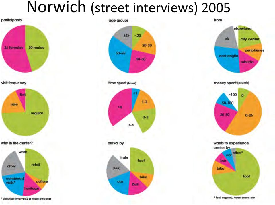
11 Norwich (street interviews) 2005
12 But What do people really do? Source: cooltownstudios.com Urbanism on Track / Sensing the City

13 Motivation Lack of knowledge about (real) movement : routing, destinations, duration. Visual method: mapping of results Tool for evaluating change : before and after intervention, benchmarking cities and places Input for application : analysis for evidence-based design Urbanism on Track / Sensing the City

14 Research Questions How to measure efficiency of investments in public space? Develop a methodology for a comparative study in place and time! How to apply this in different cities in different countries? Field research in different spatial, social & administrative context Traditional methods Questionnaire, mapping Interview Online questionnaires Counting Can technology help us out? Urbanism on Track / Sensing the City

15 Technology Source: skypotrol.net Urbanism on Track / Sensing the City

16 Following the footsteps Collecting spatio-temporal data images: Microsoft Office clip art Urbanism on Track / Sensing the City

17 gps/gnss Technique meant for orientation & navigation, ie Daily life, business, tourism, outdoor, But ART But research Urbanism on Track / Sensing the City

18 Way of Working Tracking research Tracking device: GPS-logger People: activities in Public Space Mapping : observation & analysis images: Microsoft Office clip art Urbanism on Track / Sensing the City

19 GPS devices and forms TD/09

20 GPS tracking Data collections framework Data collection (field) Layering Correlation & Calculation Retrieval Data processing (office] Reduction Modeling (agents) Data mining Selection/spatial clustering Leveling (interpretation) Interpretation & Visualisation Report/presentation Design interventions Application (city) Urbanism on Track / Sensing the City
 Urbanism on Track / Sensing")
21 Layering information Analysis framework GPS tracks (process) Retrieval Questionnaires (meta-data) ArcGIS (analysis/visualisation)! Discovering à Understanding à Defining Issues à Interventions : Solving problems Initiating new perspectives Data sources (maps/statistics) Urbanism on Track / Sensing the City
22 Method Kernel Density : points/tracks to intensity Urbanism on Track / Sensing the City
23
24
25
26
27
28
29 Place(s) Source: cooltownstudios.com Urbanism on Track / Sensing the City
30 Norwich (UK) Rouen (F) Koblenz (D)
31 Aerial picture Points of Interest Access points Commercial activities Urbanism on Track / Sensing the City Source: Van der Spek / Report: GPS Tracking Norwich (2008/02/20)
32
33
34
35
36
37
38
39
40
41
42 Aerial picture Points of Interest Access points Commercial activities Urbanism on Track / Sensing the City Source: Van der Spek / Report: GPS Tracking Norwich (2008/02/20)
43
44
45
46
47
48
49
50
51
52
53 Aerial picture Points of Interest Access points Commercial activities Urbanism on Track / Sensing the City Source: Van der Spek / Report: GPS Tracking Norwich (2008/02/20)
54
55
56
57
58
59
60
61
62
63 Where is the Money going? Investments Norwich
64 Investments Rouen
65 Investments Koblenz
66 Conclusions & observations All: people don t know their car license plate number Distribution/participation: Germans skeptical (privacy issue), UK = OK, French not aware Duration: French overall shortest duration. Origin: lunch break. French: 2 hrs and 2-4 hrs patterns is not that different. Shops are longer open and thus longer attractive (all resulting in more leisure ) In Norwich locals spent more time (2-4hrs; >4hrs) Urbanism on Track / Sensing the City
67 Conclusions & observations 2 Route concept: German locals most efficient (in-out, short circuits), parking is chosen irt destination; tourist in Koblenz cover larger area then locals vs Locals in Rouen cover large area, tourists are more efficient (limited destination area); Norwich idem, but here locals spent most time. Locals were far more represented in Norwich, although all cities have a comparable regional function. Urbanism on Track / Sensing the City
68 Sensing the City Source: wonderfulengineering.com Urbanism on Track / Sensing the City
69 SMARTPHONE as mobile SENSOR Calling (microphone) Light sensor Communication GSM/3G/4G Wifi Bluetooth Position (GNSS) camera movement (accellerometer) (Gyro) Interface (touch) temperature moist Altitude (air pressure) Source: mojdroid.pl (layar) Urbanism on Track / Sensing the City
70 Location awareness It s embedded everywhere Facebook, Twitter, Foursquare, LinkedIn/TripIt Flickr/Youtube/ Map services And many more! Which application does NOT require your current location today? Urbanism on Track / Sensing the City
71 Technology Real-time monitoring Smart-Phone GPS + data connection Scanners (RFID/Wifi/Bluetooth/ ) Post-processing GPS Other off-line logger Urbanism on Track / Sensing the City
72 Sensing Technology for location awareness Proximity versus Positioning Proximity (scanning, sniffling) RFID, GSM, Wifi Network (antenna) series of sensors Positioning (trilateration, fingerprinting) GNSS, 3G/4G, WiFi Device, network or device + network-assisted Realtime (online) ß à post-processing Urbanism on Track / Sensing the City
73 Wifi [waifi] Technology meant for communication standard for wireless data exchange But we can identify unique addresses and use this for research, ie: number of (unique/repeating) visitors, (time) sequence of visits. Urbanism on Track / Sensing the City
74 bluetooth Technique meant for communication But we can identify unique addresses and use this for research, ie: number of (unique/repeating) visitors, (time) sequence of visits. Urbanism on Track / Sensing the City
75 Integration: Sensors + Data! Location-Based Service feasible Urbanism on Track / Sensing the City
76 Urbanism on Track / Sensing the City
77 What traces did you leave behind? Check at Urbanism on Track / Sensing the City
78 One Week Twitter in Delft (NL) Historic City centre Hospital School University Campus Source: University of Coimbra / Bento+Neto Urbanism on Track / Sensing the City
79 Application of Tracking Technologies in Urban Design: Research on the spatial-temporal behavior of residents of high-rise towers Online: #VPRO #NEDERLANDvanBoven Source: VPRO NL van Boven / HR11 TU Delft Urbanism on Track / Sensing the City
80 How, when and what for do you use the city (centre)? 35 students, 35 families, 35 Bluetooth scanners Students: Approaching participants, collecting data, processing data, visualization, reporting, presenting Urbanism on Track / Sensing the City
81 Where it all started Urbanism on Track / Sensing the City
82 Publications Books Urbanism on Track / Sensing the City
Visualizing pedestrian flows using GPS-tracking to improve inner-city quality (No. 200)
") Visualizing pedestrian flows using GPS-tracking to improve inner-city quality (No. 200) Authors Tine van Langelaar and Stefan van der Spek Affiliation and contact Langelaar, Christine Maria van BBA BBE
Visualizing pedestrian flows using GPS-tracking to improve inner-city quality (No. 200) Authors Tine van Langelaar and Stefan van der Spek Affiliation and contact Langelaar, Christine Maria van BBA BBE
Marko Hännikäinen Tampere University of Technology IoT week 17.6.2013 CLOUD-BASED SERVICE PLATFORM FOR WIRELESS SENSOR NETWORKS
 Marko Hännikäinen Tampere University of Technology IoT week 17.6.2013 CLOUD-BASED SERVICE PLATFORM FOR WIRELESS SENSOR NETWORKS Outline The WAPS project Development steps 1. Low-power wireless sensor networks
Sensor Fusion Mobile Platform Challenges and Future Directions Jim Steele VP of Engineering, Sensor Platforms, Inc.
 Sensor Fusion Mobile Platform Challenges and Future Directions Jim Steele VP of Engineering, Sensor Platforms, Inc. Copyright Khronos Group 2012 Page 104 Copyright Khronos Group 2012 Page 105 How Many
THE NEED TO IMPLEMENT CONSTRUCTION DEFORMATION SPATIAL MONITORING SYSTEMS IN ROMANIA
 THE NEED TO IMPLEMENT CONSTRUCTION DEFORMATION SPATIAL MONITORING SYSTEMS IN ROMANIA Cristian ONU, Lecturer PhD. Eng., Technical University Gheorghe Asachi of Iasi, Romania, e-mail: cristi_onu@yahoo.com
Mobile Commerce and Ubiquitous Computing. Chapter 6
 Mobile Commerce and Ubiquitous Computing Chapter 6 Learning Objectives 1. Discuss the value-added attributes, benefits, and fundamental drivers of m-commerce. 2. Describe the mobile computing infrastructure
A framework for Itinerary Personalization in Cultural Tourism of Smart Cities
 A framework for Itinerary Personalization in Cultural Tourism of Smart Cities Gianpaolo D Amico, Simone Ercoli, and Alberto Del Bimbo University of Florence, Media Integration and Communication Center
Novel AMR technologies and Remote Monitoring
 Novel AMR technologies and Remote Monitoring Marios Milis, SignalGeneriX Ltd marios.milis@signalgenerix.com 1 AMR Overview AMR is the technology of automatically collecting consumption, diagnostic, and
RETAILING STORE TRACKING CUSTOMER-FIRST. Customers have three currencies which they can spend: Money, Time and Emotion
 CUSTOMER-FIRST RETAILING GROWING RETAIL SALES WITH CUSTOMER CENTRIC STRATEGIES By Jason Nathan STORE TRACKING HOW CUSTOMERS SHOP IN-STORE IN THE DIGITAL AGE When shopping, customers have three currencies
How To Create A Retail Analytics Platform With Tapway
 How to revolutionize brickand-mortar retail industry with big data analytics? April 20, 2015 Agenda Tapway Introduction & Why We Do What We Do Technology Overview In-store Analytics for Retail Chains Shopper
Crowdsourcing mobile networks from experiment
 Crowdsourcing mobile networks from the experiment Katia Jaffrès-Runser University of Toulouse, INPT-ENSEEIHT, IRIT lab, IRT Team Ecole des sciences avancées de Luchon Networks and Data Mining, Session
IP-S2 Compact+ 3D Mobile Mapping System
 IP-S2 Compact+ 3D Mobile Mapping System 3D scanning of road and roadside features Delivers high density point clouds and 360 spherical imagery High accuracy IMU options without export control Simple Map,
From Higgs to Healthcare Big Data for better business and society! Egge van der Poel Parttime Clinical Data Scientist @ Erasmus MC, Parttime
 From Higgs to Healthcare Big Data for better business and society! Egge van der Poel Parttime Clinical Data Scientist @ Erasmus MC, Parttime Freelance Data Scientist @ EggeWel, fulltime curious ANP De
Location Based Services for Enterprise
 Location Based Services for Enterprise Introduction WHITEPAPER Location Based Services (LBS) have been making foray into enterprise applications, thanks to the rise in smartphone ownership and the phenomenal
The Design and Implementation of a Cloud-Based Tour Guide System for the Taiwan Lantern Festival
 Proceedings of International Symposium on City Planning 2013 The Design and Implementation of a Cloud-Based Tour Guide System for the Taiwan Lantern Festival *1Dr. Hung Nien Hsieh, *2Dr. Hsin Wen Chang,
SECURITY & ACCESS CONTROL SYSTEM BASED PROJECTS
 ************************************************************************ INNOVATIVE & APPLICATION ORIENTED PROJECTS ON SVSEMBEDDED SYSTEMS (8051/AVR/ARM7/MSP430/RENESAS/ARM cortex M3) ************************************************************************
MOBILE MARKETING. A guide to how you can market your business to mobile phone users. 2 April 2012 Version 1.0
 MOBILE MARKETING A guide to how you can market your business to mobile phone users 2 April 2012 Version 1.0 Contents Contents 2 Introduction 3 Skill Level 3 Terminology 3 Video Tutorials 4 What is Mobile
Properties and Tracking of Movements
 Second Conference of Junior Researchers in Civil Engineering 6 Properties and Tracking of Movements Zoltan Koppanyi BME Department of Photogrammetry and Geoinformatics, e-mail: zoltan.koppanyi@fmt.bme.hu
Sensors talk and humans sense Part II
 Sensors talk and humans sense Part II Athena Vakali Palic, 6 th September 2013 OSWINDS group Department of Informatics Aristotle University of Thessaloniki http://oswinds.csd.auth.gr SEN2SOC Architecture
How To Analyze Tourist Mobility With Gps
 GPS-TRACKING COMBINED WITH TABLET-BASED INTERVIEWS An approach to analyze tourist mobility Anne Menzel Thomas Spangenberg Sven Gross 1 Instruction The content is available ailable for private use. In the
MOBILITY DATA MODELING AND REPRESENTATION
 PART I MOBILITY DATA MODELING AND REPRESENTATION 1 Trajectories and Their Representations Stefano Spaccapietra, Christine Parent, and Laura Spinsanti 1.1 Introduction For a long time, applications have
Copyright 2015 Addo Consulting Inc 400 North Washington Street, Suite 100, Falls Church, VA, USA - 22046
 *The smallest variation has been spaced specifically for legibitlity Copyright 2015 Addo Consulting Inc 400 North Washington Street, Suite 100, Falls Church, VA, USA - 22046 Table Of Contents Page 3 Introduction
SMART CARD DATA IN A PERIPHERAL REGION: HOW SMART CARD DATA CAN BE USED TO ILLUMINATE THE FLOW OF PUBLIC TRANSPORT PASSENGERS IN NORTHERN JUTLAND
 IN A PERIPHERAL REGION: HOW CAN BE USED TO ILLUMINATE THE FLOW OF PUBLIC TRANSPORT PASSENGERS IN NORTHERN JUTLAND PRESENTATION FOR TØF BIG KONFERENCE 2 TH OF DECEMBER 2015 KRISTIAN HEGNER REINAU, ASSOCIATE
10/14/11. Big data in science Application to large scale physical systems
 Big data in science Application to large scale physical systems Large scale physical systems Large scale systems with spatio-temporal dynamics Propagation of pollutants in air, Water distribution networks,
Big Data for Transportation: Measuring and Monitoring Travel
 1 Big Data for Transportation: Measuring and Monitoring Travel Frank Franczyk, MSc. P.Eng., Benoit Coupal, MSc. Persen Technologies Incorporated (PERSENTECH) Introduction Relevant and reliable transportation
3D-visualisation of Activity Patterns in Public Space
 3D-visualisation of Activity Patterns in Public Space Stefan van der Spek a,1 b and Steffen Nijhuis a Chair of Urban Design, Department of Urbanism, Faculty of Architecture, Delft University of Technology,
Acquire WayFinder. Revolutionising digital interaction.
 Revolutionising digital interaction. Interactive Touchscreen Maps. The Acquire WayFinder solution, is an interactive touch screen solution that enables customers and visitors to locate and navigate to
Geo Mindstorms. Investigating a sensor information framework for disaster management processes. Steven Fruijtier Geodan S&R
 Geo Mindstorms Investigating a sensor information framework for disaster management processes Steven Fruijtier Geodan S&R Content > Sensors in disaster management Use of sensors Problems encountered as
City Deploys Big Data BI Solution to Improve Lives and Create a Smart-City Template
 City Deploys Big Data BI Solution to Improve Lives and Create a Smart-City Template Overview Customer: Customer Website: http://www.bcn.cat/en/ Country or Region: Spain Industry: Government Customer Profile
Governance van Mobiele Service Platforms
 Governance van Mobiele Service Platforms Trends en ontwikkelingen Dr. ir. Mark de Reuver Section Information and Communication Technology Faculty Technology Policy and Management Delft University of Technology
USING MOBILE TECHNOLOGY TO GROW YOUR BUSINESS. Version 3.0
 USING MOBILE TECHNOLOGY TO GROW YOUR BUSINESS Version 3.0 13 September 2012 What We Will Cover Today Overview of the Mobile Market SMS QR Codes Location Based Services Native apps Mobile websites Augmented
2008 Thomson, a part of the Thomson Corporation. Thomson, the Star logo, and Atomic Dog are trademarks used herein under license.
 Thomson, the Star logo, and Atomic Dog are trademarks used herein under license. All rights reserved. INTERNET MARKETING: INTEGRATING ONLINE AND OFFLINE STRATEGIES Chapter 14 The Future -- Wireless and
B.E. Mikkelsen, A.K. Lyseen, M. Dobroczynski, and H.S. Hansen
 Behavioural Nutrition & Big Data How Geodata, Register Data & GPS, Mobile Positioning, Wi-Fi, Bluetooth & Thermal Cameras Can Contribute to the study of human food behaviour Abstract: Place has traditionally
Can the smartphone sensors be used for wheelchair accessibility studies? Dr. Manik Gupta Dr. Behzad Heravi Dr. Catherine Holloway Prof.
 Can the smartphone sensors be used for wheelchair accessibility studies? Dr. Manik Gupta Dr. Behzad Heravi Dr. Catherine Holloway Prof. Steve Hailes Outline Research motivation Importance of wheelchair
Is the Future of Public Service Delivery Mobile-Only?
 Is the Future of Public Service Delivery Mobile-Only? 10 th Public Sector IT Conference, Dublin, 31 Oct. 2014 Norbert Sagnard Managing Consultant Sagnard Associates IRELAND 2014 A MOBILE SOCIETY Ireland:
EMBEDDED MAJOR PROJECTS LIST
 EMBEDDED MAJOR PROJECTS LIST WEBSERVER ETHERNET - CAN BASED APPLICATION 1 WEB-BASED STUDENT ATTENDANCE SYSTEM USING RFID TECHNOLOGY 2 THE COMMON DATA ACQUISITION SYSTEM BASED ON ARM7 3 CAN BASED ACCIDENT
Lecture Embedded System Security A. R. Sadeghi, @TU Darmstadt, 2011 2012 Introduction Mobile Security
 Smartphones and their applications have become an integral part of information society Security and privacy protection technology is an enabler for innovative business models Recent research on mobile
General background on mobile devices and solutions including context awareness
 General background on mobile devices and solutions including context awareness Kjell Are Refsvik 20 January 16, 2012 IMT2551 Mobile Systems Fundamentals CC: BY-NC-SA http://www.ansatt.hig.no/kjellr/imt2551
Recommendations in Mobile Environments. Professor Hui Xiong Rutgers Business School Rutgers University. Rutgers, the State University of New Jersey
 1 Recommendations in Mobile Environments Professor Hui Xiong Rutgers Business School Rutgers University ADMA-2014 Rutgers, the State University of New Jersey Big Data 3 Big Data Application Requirements
Evolution. Personal Assistant. of the. Tom Minifie. Chief Technology Officer, AVST
 Evolution of the Personal Assistant Tom Minifie Chief Technology Officer, AVST AVST Experience Personal Assistant 15 + YEARS Speech Recognition 15 + YEARS Business Process 20 + YEARS Unified Messaging
Spatio-Temporal Patterns of Passengers Interests at London Tube Stations
 Spatio-Temporal Patterns of Passengers Interests at London Tube Stations Juntao Lai *1, Tao Cheng 1, Guy Lansley 2 1 SpaceTimeLab for Big Data Analytics, Department of Civil, Environmental &Geomatic Engineering,
Feasibility of Car-Sharing Service in Hangzhou, China
 Feasibility of Car-Sharing Service in Hangzhou, China 1 Project Members 2 Project Goals 3 In depth feasibility study of launching a car sharing service in Hangzhou Provide possible ways of implementing
TOP TECHNOLOGIES THAT TRACK AND MEASURE ATTENDEE BEHAVIOR BRAD KAUFMAN, PRESIDENT, EXPERI-TECH MARYBETH HALL, PRESIDENT, BROWN PELICAN GROUP
 TOP TECHNOLOGIES THAT TRACK AND MEASURE ATTENDEE BEHAVIOR BRAD KAUFMAN, PRESIDENT, EXPERI-TECH MARYBETH HALL, PRESIDENT, BROWN PELICAN GROUP What is the focus of Experiential Technology? More deeply engage
Monitoring and Mining Sensor Data in Cloud Computing Environments
 Monitoring and Mining Sensor Data in Cloud Computing Environments Wen-Chih Peng and Yu-Chee Tseng Dept. of Computer Science National Chiao Tung University {wcpeng, yctseng}@cs.nctu.edu.tw 1 Outline Sensor
GLOSSARY OF TERMS Beacon Management App API (Application Programming Interface) CMS (Content Management System) App
 CMS (Content Management System) App") beaconsense.co.uk GLOSSARY OF TERMS Beacon A small, low-cost, low-powered Bluetooth transmitter Management App Ability to programme and assign beacon a function API (Application Programming Interface)
beaconsense.co.uk GLOSSARY OF TERMS Beacon A small, low-cost, low-powered Bluetooth transmitter Management App Ability to programme and assign beacon a function API (Application Programming Interface)
Results of IMES (Indoor Messaging System) Implementation for Seamless Indoor Navigation and Social Infrastructure Platform
 Implementation for Seamless Indoor Navigation and Social Infrastructure Platform") Results of IMES (Indoor Messaging System) Implementation for Seamless Indoor Navigation and Social Infrastructure Platform Dinesh Manandhar, Seiya Kawaguchi, Hideyuki Torimoto GNSS Technologies Inc., Japan
Results of IMES (Indoor Messaging System) Implementation for Seamless Indoor Navigation and Social Infrastructure Platform Dinesh Manandhar, Seiya Kawaguchi, Hideyuki Torimoto GNSS Technologies Inc., Japan
Developments in Geomatics Education. Spatial Information Sciences
 Developments in Geomatics Education Spatial Information Sciences FSCSI FRICS Education in Spatial Information Sciences in Ireland 1. Third-Level Education in Ireland 2. Third-Level Education in the UK
Developing And Marketing Mobile Applications. Presented by: Leesha Roberts, Senior Instructor, Center for Education Programmes, UTT
 Developing And Marketing Mobile Applications Presented by: Leesha Roberts, Senior Instructor, Center for Education Programmes, UTT MOBILE MARKETING What is a Mobile App? A mobile app is a software application
E-Commerce: The Make-or-Break for Hong Kong s Future Trading/ Retail Businesses
 E-Commerce: The Make-or-Break for Hong Kong s Future Trading/ Retail Businesses 2015 Hong Kong R&D Centre for Logistics and Supply Chain Management Enabling Technologies. All rights reserved. China: The
Remote Monitoring of Livestock Wireless and the Wii Improving Livestock Welfare
 Remote Monitoring of Livestock Wireless and the Wii Improving Livestock Welfare Ian McCauley Greg Cronin Michelle Watt Samantha Borg Future Farming Systems Research, DPI Vic Outline Wireless Technologies
How will the convergence of LOCATION
 How will the convergence of LOCATION TECHNOLOGIES such as RFID, GPS, RTLS, and LBS AFFECT BUSINESS? By David H. Williams and Gary Hartwig How do manufacturers and diseach vehicle as it unloads with tributors
The Internet of Things... Hype or not?
 The Internet of Things... Hype or not? Filip De Maeyer Philip Leenders 2013 global revenues of USD 5.8 billion Client-centric, services-focused business 73% of Global Fortune 100 and 59% of Global Fortune
Big Data Analytics in Mobile Environments
 1 Big Data Analytics in Mobile Environments 熊 辉 教 授 罗 格 斯 - 新 泽 西 州 立 大 学 2012-10-2 Rutgers, the State University of New Jersey Why big data: historical view? Productivity versus Complexity (interrelatedness,
INTERNET OF THINGS Recent Advances and Applications MengChu Zhou, Tongji University and New Jersey Institute of Technology
 INTERNET OF THINGS Recent Advances and Applications MengChu Zhou, Tongji University and New Jersey Institute of Technology What is the next Industrial Revolution? The 1st answer People producing their
Computer/IT Project LIST. Contact: 9860171201 8796142757
 Computer/IT Project LIST Contact: 9860171201 8796142757 1. Detecting E Banking Phishing Websites Using Associative Classification 2. Vehicle Tracking Using Driver Mobile Gps Tracking 3. Sentiment Analysis
Lecture 7: Privacy and Security in Mobile Computing. Cristian Borcea Department of Computer Science NJIT
 Lecture 7: Privacy and Security in Mobile Computing Cristian Borcea Department of Computer Science NJIT Location Privacy Location Authentication Trusted Ad Hoc Networks 2 Privacy Violated Request: Retrieve
M-Traveling: Mobile Applications in Tourism
 International Journal for Infomics (IJI), Volume 5, Issue 3/4, September/December 2012 M-Traveling: Mobile Applications in Tourism André Constanti da Silva Institute of Computing (PG) UNICAMP IFSP Heloísa
TU/e Bachelor College 2014-2015 ELECTRICAL ENGINEERING // I DREAM OF ASPHALT LANES THAT CHARGE ELECTRIC CARS // Bachelor College
 TU/e Bachelor College 2014-2015 // I DREAM OF ASPHALT LANES THAT CHARGE ELECTRIC CARS // Bachelor College ELECTRICAL ENGINEERING // field. If I can do my bit, then I am happy to do so! // I DREAM OF ASPHALT
On measuring tourism: the new world of big data, the internet and social media
 On measuring tourism: the new world of big data, the internet and social media Daniel R. Fesenmaier Professor and Director National Laboratory for Tourism & ecommerce Temple University Travel and Tourism
LOCATION BASED SERVICES FOR RETAIL
 LOCATION BASED SERVICES FOR RETAIL CURRENT GLOBAL TRENDS -3% retailers can identify the buyer at the entrance to the shop, 72% plan to implement this within 5 years* -28% of retailers are using mobile
INDIVIDUAL COURSE DETAILS
 INDIVIDUAL COURSE DETAILS A. Name of Institution NATIONAL INSTITUTE OF TECHNICAL TEACHERS TRAINING AND RESEARCH TARAMANI CHENNAI 600 113 [An Autonomous Institute under Ministry of Human Resource Development,
REAL TIME MONITORING AND TRACKING SYSTEM FOR AN ITEM USING THE RFID TECHNOLOGY
 Review of the Air Force Academy No 3 (30) 2015 REAL TIME MONITORING AND TRACKING SYSTEM FOR AN ITEM USING THE RFID TECHNOLOGY For the past few years, location systems have become a major studying field,
The Case for Device Namespaces
 The Case for Device Namespaces Oren Laadan September 18, 2013 www.cellrox.com aprilzosia Device Namespaces Roots Based on research at Columbia University: Cells: A Virtual Mobile Smartphone Architecture
TomTom Navigation app for iphone/ipad Reference Guide
 TomTom Navigation app for iphone/ipad Reference Guide Contents Getting Started 6 Start TomTom Navigation app for iphone/ipad... 6 Updating your TomTom Navigation app for iphone/ipad... 6 Sharing information
BIG DATA ANALYTICS FOR HOSPITALITY AND LEISURE Learn more about your customers than ever before!
 BIG DATA ANALYTICS FOR HOSPITALITY AND LEISURE Learn more about your customers than ever before! Insights Visitor is at the forefront of consumer insights and visitor analytics platforms, enabling you
INNOVATION CITIES: INTERNATIONAL ACADEMIC CONTEST. Creation of a concept for a smart identification system. for the city of Yverdon-les-Bains
 INNOVATION CITIES: INTERNATIONAL ACADEMIC CONTEST Creation of a concept for a smart identification system for the city of Yverdon-les-Bains Imagine a city where vehicles, people, objects, infrastructures
PhoCA: An extensible service-oriented tool for Photo Clustering Analysis
 paper:5 PhoCA: An extensible service-oriented tool for Photo Clustering Analysis Yuri A. Lacerda 1,2, Johny M. da Silva 2, Leandro B. Marinho 1, Cláudio de S. Baptista 1 1 Laboratório de Sistemas de Informação
Mobile Application GPS-Based
 3 Mobile Application GPS-Based Berta Buttarazzi University of Tor Vergata, Rome, Italy 1. Introduction Most of navigators for mobile devices have a big failure; they do not notify the user of road condition
REGULATIONS FOR THE DEGREE OF MASTER OF SCIENCE IN COMPUTER SCIENCE (MSc[CompSc])
![REGULATIONS FOR THE DEGREE OF MASTER OF SCIENCE IN COMPUTER SCIENCE (MSc[CompSc])](/thumbs/33/16674036.jpg "REGULATIONS FOR THE DEGREE OF MASTER OF SCIENCE IN COMPUTER SCIENCE (MSc[CompSc])") 305 REGULATIONS FOR THE DEGREE OF MASTER OF SCIENCE IN COMPUTER SCIENCE (MSc[CompSc]) (See also General Regulations) Any publication based on work approved for a higher degree should contain a reference
305 REGULATIONS FOR THE DEGREE OF MASTER OF SCIENCE IN COMPUTER SCIENCE (MSc[CompSc]) (See also General Regulations) Any publication based on work approved for a higher degree should contain a reference
Bike sharing schemes (BSS)
") Bike sharing schemes (BSS) Index Purpose Description Relevance for Large Scale Events Options Technologies Impacts Integration potential Implementation Best Cases and Examples 1 of 7 Purpose The need to
Bike sharing schemes (BSS) Index Purpose Description Relevance for Large Scale Events Options Technologies Impacts Integration potential Implementation Best Cases and Examples 1 of 7 Purpose The need to
WHAT IS GEO-FENCING? (415) 580-7936 I www.brownpelicangroup.com I info@brownpelicangroup.com
 580-7936 I www.brownpelicangroup.com I info@brownpelicangroup.com") WHAT IS GEO-FENCING? Brown Pelican Group, a leading event Wi-Fi and technology company, in partnership with Experi-Tech, experts in cutting edge interactive tech for events, tradeshows, mobile tours, and
WHAT IS GEO-FENCING? Brown Pelican Group, a leading event Wi-Fi and technology company, in partnership with Experi-Tech, experts in cutting edge interactive tech for events, tradeshows, mobile tours, and
platforms Android BlackBerry OS ios Windows Phone NOTE: apps But not all apps are safe! malware essential
 Best Practices for Smartphone Apps A smartphone is basically a computer that you can carry in the palm of your hand. Like computers, smartphones have operating systems that are often called platforms.
TRACKING TOURISTS WITH GPS-TECHNOLOGY
 TRACKING TOURISTS WITH GPS-TECHNOLOGY Development of a novel android-based App European Transport Conference 2013 30th September 2013 Anne Menzel Sven Gross Thomas Spangenberg 1 Instruction The content
IP-S2 HD. High Definition 3D Mobile Mapping System
 IP-S2 HD High Definition 3D Mobile Mapping System Integrated, turnkey solution High Density, Long Range LiDAR sensor for ultimate in visual detail High Accuracy IMU and DMI Odometry for positional accuracy
Visual and mobile Smart Data
 Copyright 2013 Augmented Vision - DFKI 06.12.2013 1 Visual and mobile Smart Data Didier Stricker didier.stricker@dfki.de Department Augmented Vision @ DFKI Head: Didier Stricker Founded in July 2008 30
Resource Library. Consumer Location-Based Analytics Deliver Actionable Insights. From Platt Retail Institute s. Bringing Research to Retail SM
 From Platt Retail Institute s Resource Library Bringing Research to Retail SM See the entire PRI Resource Library at www.plattretailinstitute.org/library. Consumer Location-Based Analytics Deliver Actionable
Indoor Triangulation System. Tracking wireless devices accurately. Whitepaper
 Indoor Triangulation System Tracking wireless devices accurately Whitepaper 2 Navizon, the company that pioneered geopositioning for smart phone users with its Navizon One system, has come up with another
communication over wireless link handling mobile user who changes point of attachment to network
 Wireless Networks Background: # wireless (mobile) phone subscribers now exceeds # wired phone subscribers! computer nets: laptops, palmtops, PDAs, Internet-enabled phone promise anytime untethered Internet
PRIVATE TEXTUAL NETWORK USING GSM ARCHITECTURE
 PRIVATE TEXTUAL NETWORK USING GSM ARCHITECTURE * Qurban A. Memon, **Zubair Shaikh and ***Ghulam Muhammad * Associate Professor; **Associate Professor, ***Senior Year Student Karachi Institute of Information
Healthcare versus Biochemical Industries
 RFID in Healthcare Healthcare versus Biochemical Industries Where is the infusion pump? Where is patient Brown? Has Mrs. Jones already left the department? I cannot find the device that needs maintenance!
Vehicle Tracking System,
 Vehicle Tracking System, The Complete Solution What is GPS? Product Review. Complete system. Contact Us. What is GPS? GPS, which stands for Global Positioning System, is the only system today able to show
SENSORS ON ANDROID PHONES. Indian Institute of Technology Kanpur Commonwealth of Learning Vancouver
 SENSORS ON ANDROID PHONES Indian Institute of Technology Kanpur Commonwealth of Learning Vancouver Keerthi Kumar Samsung Semiconductors Keerthi Kumar IIT Kanpur Keerthi Kumar Overview What are sensors?
Evolving Bar Codes. Y398 Internship. William Holmes
 Evolving Bar Codes Y398 Internship By William Holmes Table of contents Introduction: What is RFID? Types of Tags: Advantages of Tags: RFID applications Conclusion: Introduction: Bar codes have evolved
How To Connect To Iridium.Com From A Cell Phone Or Tablet Device
 Wi-Fi connectivity Your smartphone or tablet device MUST be connected via Wi-Fi to Iridium GO! (ex. Iridium-06088 ) in order for the Iridium GO! application to login successfully and operate. Please check
Indoor Positioning Systems WLAN Positioning
 Praktikum Mobile und Verteilte Systeme Indoor Positioning Systems WLAN Positioning Prof. Dr. Claudia Linnhoff-Popien Michael Beck, André Ebert http://www.mobile.ifi.lmu.de Wintersemester 2015/16 WLAN Positioning
E-Business Technologies for the Future
 E-Business Technologies for the Future Michael B. Spring Department of Information Science and Telecommunications University of Pittsburgh spring@imap.pitt.edu http://www.sis.pitt.edu/~spring Overview
Introduction to Trimble Access. The Next Generation of Survey Controller S-0102
 Introduction to Trimble Access The Next Generation of Survey Controller S-0102 Questions we will answer What is Trimble Access? A suite of software applications How do they all fit together? How does it
The Future of E-Commerce: The Latest Trends and their Impact on Web and Omni-Channel Retailing
 The Future of E-Commerce: The Latest Trends and their Impact on Web and Omni-Channel Retailing Kim Baudry, Market Development Director, North America, Dematic (USA) The next 45 minutes!! Retailing 360
How Location Intelligence drives value in next-generation customer loyalty programs in Retail business
 How Location Intelligence drives value in next-generation customer loyalty programs in Retail business Andreas Nemeth a, Mikhail M. Komarov a a National Research University Higher School of Economics,
The Less Communicated Story of Location Based Service in Retail Applications
 , March 12-14, 2014, Hong Kong The Less Communicated Story of Location Based Service in Retail Applications Jessie Cai Abstract - Location based applications have been on the front pages of technological
CHATA Stampwallet Loyalty program
 CHATA Stampwallet Loyalty program What is Stampwallet? Stampwallet is a loyalty platform merchants can use to reward customers with stamps or points after a purchase or other action. It s a digital wallet
Social Data Mining through Distributed Mobile Sensing: A Position Paper
 Social Data Mining through Distributed Mobile Sensing: A Position Paper John Gekas, Eurobank Research, Athens, GR Abstract. In this article, we present a distributed framework for collecting and analyzing
Command Support System
 Command Support System The world s most advanced interoperable and resilient incident management system for emergency services, emergency management, security and homeland defence organisations. State
presenta8on(&( collabora8on(apps( op8mized(for(touch( Any$to$any(cloud(video(conferencing(network( remote,(monitoring(&(management(integra8on(
 Product Details What is mondopad? 55$in.(mul8$touch(tablet( w/collabora8on(server( presenta8on(&( collabora8on(apps( op8mized(for(touch( Any$2$Any(video( conferencing( +( +( Any$to$any(cloud(video(conferencing(network(
Considerations on Audience Measurement Procedures for Digital Signage Service
 Considerations on Audience Measurement Procedures for Digital Signage Service Wook Hyun, MiYoung Huh, SeungHei Kim and ShinGak Kang Electronics and Telecommunications Research Institute Daejeon, Republic
Vehicle Tracking System using GPRS
 Urban Transport XIII: Urban Transport and the Environment in the 21st Century 409 Vehicle Tracking System using GPRS S. Ikram 1 & F. T. Shah 2 1 Seidco Communication L.L.C, Abu Dhabi, UAE 2 COMSATS Institute
The TrimTrac Locator: A New Standard in Practical and Affordable Asset Tracking
 The TrimTrac Locator: A New Standard in Practical and Affordable Asset Tracking By Bill Dussell Director, Integrated Products Trimble Navigation 15-December-2003 1997 2003, Trimble Navigation Limited.
On measuring tourism: SMART Tourism and the challenges of big data
 On measuring tourism: SMART Tourism and the challenges of big data Jason Stienmetz Daniel R. Fesenmaier Professor and Director National Laboratory for Tourism & ecommerce Temple University 1 2 3 4 5 introductory
The future: Big Data, IoT, VR, AR. Leif Granholm Tekla / Trimble buildings Senior Vice President / BIM Ambassador
 The future: Big Data, IoT, VR, AR Leif Granholm Tekla / Trimble buildings Senior Vice President / BIM Ambassador What is Big Data? 2 Big Data is when the amount of data becomes part of the problem 3 Big
How To Develop An Open Play Context Framework For Android (For Android)
") Dynamix: An Open Plug-and-Play Context Framework for Android Darren Carlson and Andreas Schrader Ambient Computing Group / Institute of Telematics University of Lübeck, Germany www.ambient.uni-luebeck.de
Dynamix: An Open Plug-and-Play Context Framework for Android Darren Carlson and Andreas Schrader Ambient Computing Group / Institute of Telematics University of Lübeck, Germany www.ambient.uni-luebeck.de
RFID, GPS & GSM Based Vehicle Tracing & Employee Security System
 RFID, GPS & GSM Based Vehicle Tracing & Employee Security System Ms.S.S.Pethakar, Prof. N. Srivastava, Ms.S.D.Suryawanshi Abstract A RFID, GPS & GSM Based Vehicle Tracking and Employee Security System