Presented by: Dr. Senanu Ashiabor, Intermodal Logistics Consulting Inc. at 2015 North Carolina MPO Conference April 30, 2015
|
|
|
- Melina Clarke
- 8 years ago
- Views:
Transcription


1 Presented by: Dr. Senanu Ashiabor, Intermodal Logistics Consulting Inc. at 2015 North Carolina MPO Conference April 30, 2015

2 What is Big Data? Big data is a broad term for large datasets that are so large or complex that traditional data processing applications are inadequate. Challenges include analysis, capture, curation, search, sharing, storage, transfer, visualization, and information privacy (Wikipedia definition) Industry expert Doug Laney popularized the three Vs definition based on Volume, Velocity and Variety: Increasing Volume (sensor generated data) Velocity/Speed of data generation (automated data collection) Variety of data structure (numeric, text, video, audio, etc.) 2
 Industry expert Doug Laney popularized the three Vs definition based on Volume, Velocity and Variety: Increasing Volume (sensor")
3 Wide Range of Data Sources Single-Point Sensors: are generally stationary and measure traffic volumes, vehicle classifications, and spot speeds within a limited detection range Multi-Point Sensors: have capabilities to identify and match vehicles across multiple detectors (Bluetooth, video license plate matching, vehicle signature matching technologies) Data is precise enough for real time system monitoring, traveler information, and demand modeling purposes Not sufficiently precise for signal timing, or microsimulation purposes. Permanent detectors have a high installation cost but comparatively low operating and maintenance costs when compared to portable temporary detectors. 3

4 Wide Range of Data Sources Probe data sources/vehicles: measure route specific travel times and can identify slow down points within the route High level of accuracy for route specific applications, but costs generally limit method to single routes for a few hours at a time Adequate for signal timing and microsimulation purposes but too costly for real time system monitoring, traveler information, or demand modeling purposes Area-wide Sensory Data (Data Fusion): provide continual coverage over a wide area and are closet to Big Data Examples include cell phone and GPS device tracking Credible point-to-point travel times, average speeds, and performance information on network, but precision at the link level may be limited. Adequate for real time system monitoring, traveler information, and transportation demand modeling purposes, but not sufficiently precise for signal timing or microsimulation purposes. 4

5 Real time Systems Monitoring Traveler Information applications Transportation Demand Modeling Signal Timing Micro-simulation Performance Management Typical Data Applications Single-Point Sensor (Loops, video cameras, etc.) X X *X *X Multi Point Sensors (Bluetooth, Lincense Plate Matching) X X *X *X *X *X Probe Vehicles X X Areawide Sensors (mobile devices, aerial photography) X X X *X Data Fusion Applications X X X *X 5
 X X *X *X Multi Point Sensors (Bluetooth, Lincense Plate Matching) X X *X *X *X *X Probe Vehicles X X")
6 You May Already Own Big Data Most of your traffic operations data can be repurposed for Planning Applications Orange County Arterial Performance Monitoring Los Angeles DOT Congestion Monitoring Extensive city-wide coverage with existing mid-block detectors 30 second reporting of vehicle volume and occupancy across detectors Limited information on location (latitude/longitude) of mid-block detector Detailed information on off-set from intersections 6
 of mid-block detector Detailed information on off-set from")
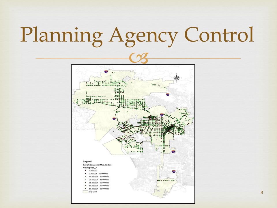
7 You Can Use It for Congestion Monitoring Speeds from Floating Car Runs Conducted floating car runs over selected corridors Speeds from mid-block detectors Collected and verified detector locations on those corridors Obtained detector Occupancy and Volumes from ATSAC Estimated detector spot speed = f(volume, Occupancy, vehicle length, detection zone length) Convert detector speeds to corridor running speeds (NCHRP 3-79) Calibrated regression model between detector running speeds and floating car speeds Result: capability to estimate corridor running speeds (including signal delays) across the LA City network from mid-block detectors 7
 across the LA City network from")
8 Planning Agency Control 8
9 FHWA Performance Areawide Data Set Data purchased by FHWA from private vendors (Nokia HERE) and made available to MPOs and State transportation agencies FHWA National Performance Monitoring Research Data Set (NPMRDS) data set started being collected from July 2013 Monthly archives are released 2 weeks after the end of each month Data reported at each Traffic Message Channel (TMC) locations across the National Highway System Average travel time reported every 5 minutes for passenger vehicles, freight vehicles, and all vehicles at all TMCs GIS network shape file with Traffic Message Chanel locations and link length Data is not imputed ~ cells without records are left empty 9

10 Data Extraction & Processing Data is released at State level so files are large and take time to download Files can be opened with MS Access but not MS Excel Specialized database scripting tools such as MySQL, Matlab, etc. are better able to handle data Travel time data records need to be linked through a series of steps with the TMC and Network shape files Advisable to needs to be summarize data before integrating into GIS Above sounds intimidating and complex, but because of structured format of data, once a process is setup to extract data, scripts can be re-used every month. 10

11 Possible MPO Applications Travel Time Monitoring: 5 minute data can be aggregated to report travel time (hourly, peak, non-peak) on any section of the NHS network Congestion Measurement: travel times and speeds can be synthesized to identify congested intersections and corridors on the network on a continual basis Performance Metrics: identify peak travel periods, estimate reliability metrics, derive total peak hour travel time and speed and vehicle hours of delay Performance Evaluation: identify and monitor bottleneck locations, evaluate the impact of measures implemented to address those locations, and assess the effectiveness of performance-based transportation investment decisions 11

12 Possible MPO Applications Freight Performance Measurement: the freight travel time information in the data can be used to estimate freight related versions of all the metrics mentioned earlier. The ability to continually measure the metrics above provides MPOs and DOTs with extensive performance monitoring capabilities. Agencies can use the data in a range of planning activities including their congestion monitoring programs (CMPs), long range plans, and travel demand model calibration. 12

13 NPMRDS: Planning Time Index Developed by Wisconsin TOPS Laboratory PTI = Congested TT/Free-flow TT 13

14 Truck vrs Vehicle Speeds University of Minnesota 14

15 Truck Congestion University of Minnesota 15

16 Statewide Performance Data I-95 Vehicle Probe Project is a very rich mobile probe data purchased coalition of states along the I-95 interstate corridor (I-95 Coalition) Initially purchased data from INRIX, but vendors have been increased to include HERE and TomTom Both Real-time and historical vehicle probe data Well developed Graphical User Interface Data has been cleaned and empty cells imputed Available for free to MPOs and State agencies University of Maryland is in the process of integrating NPMRDS data into I-95 INRIX 16

17 Some Caveats to Note Understand how the data was assembled Institute basic data validation procedures (QA/QC) Do not over rely on volume of data a wrong trend from large dataset makes you more confident you are right when you are just wrong Mobile Data California Household Survey versus Mobile Data Source 17

18 Data Acquisition Challenges Partnering with multiple agencies is a very cost effective means of controlling costs and improving outcomes when acquiring new technologies Whenever possible negotiate or ask for documentation of the processing (blending, fusion, quality control) of the data as this will affect what the data can be used for (bias) Data Use License should allow sharing the data among agencies and the general public during vendor Privacy protections, licensing terms, and intellectual property issues are particularly thorny issues to work out 18

19 Questions and Discussion 19

Public Sector Solutions
 Public Sector Solutions The New Jersey DOT Command Center uses INRIX real-time data and analytics to monitor congestion and deploy resources proactively to manage traffic flow and inform travelers. INRIX
Integrating the I-95 Vehicle Probe Project Data and Analysis Tools into the FAMPO Planning Program
 Integrating the I-95 Vehicle Probe Project Data and Analysis Tools into the FAMPO Planning Program I-95 Corridor Coalition Background The I-95 Corridor Coalition is an alliance of transportation agencies,
TRAVEL TIME BASED OKLAHOMA CONGESTION ANALYSIS: Pilot Study
 Technical Memorandum TRAVEL TIME BASED OKLAHOMA CONGESTION ANALYSIS: Pilot Study Prepared for: Oklahoma Department of Transportation Prepared by: November 2014 Technical Memorandum The Technical Memos
Private Sector Data for Performance Management Final Report
 Private Sector Data for Performance Management Final Report July 2011 QUALITY ASSURANCE STATEMENT The U.S. Department of Transportation provides high-quality information to serve Government, industry,
Texas Freight Advisory Committee A PRIMER ON PUBLIC SECTOR FREIGHT PERFORMANCE MEASURES
 Texas Freight Advisory Committee A PRIMER ON PUBLIC SECTOR FREIGHT PERFORMANCE MEASURES October 1, 2013 A PRIMER ON PUBLIC SECTOR FREIGHT PERFORMANCE MEASURES How Do Performance Measures Assist the Public
Doppler Traffic Flow Sensor For Traveler Information Systems. October, 2007 1
 Doppler Traffic Flow Sensor For Traveler Information Systems October, 2007 1 Traffic congestion costs $70B a year Road construction can t keep up with demand Congestion spreading to smaller cities Many
INVESTIGATION OF ASIM 29X, CANOGA, RTMS, SAS-1, SMARTSENSOR, TIRTL & OTHER SENSORS FOR AUTOMATIC VEHICLE CLASSIFICATION
 INVESTIGATION OF ASIM 29X, CANOGA, RTMS, SAS-1, SMARTSENSOR, TIRTL & OTHER SENSORS FOR AUTOMATIC VEHICLE CLASSIFICATION RESEARCH NEED This research will add to the national and local state-of-the-art on
USE OF STATE FLEET VEHICLE GPS DATA FOR TRAVEL TIME ANALYSIS
 USE OF STATE FLEET VEHICLE GPS DATA FOR TRAVEL TIME ANALYSIS David P. Racca Center for Applied Demography and Survey Research (CADSR) University of Delaware Graham Hall, Rm 284, Newark, Delaware 19716
Traffic Monitoring Guide May 1, 2001. Vehicle Classification Monitoring
 Vehicle Classification Monitoring SECTION 4 CONTENTS Section Page CHAPTER 1 INTRODUCTION...4-1 Variability...4-1 Data Collection to Account for Truck Movements...4-2 Integration of Classification Counting
GPS TRUCK DATA PERFORMANCE MEASURES PROGRAM IN WASHINGTON STATE
 Draft Research Report Agreement T4118, Task 31 Truck Performance Measure Research Project GPS TRUCK DATA PERFORMANCE MEASURES PROGRAM IN WASHINGTON STATE by Edward McCormack and Wenjuan Zhao University
22 nd ITS World Congress Towards Intelligent Mobility Better Use of Space. GPS 2: Big Data The Real Value of Your Social Media Accounts
 22 nd ITS World Congress Towards Intelligent Mobility Better Use of Space GPS 2: Big Data The Real Value of Your Social Media Accounts October 7, 2015 Kenneth Leonard Director, Intelligent Transportation
TURNING DATA INTO INFORMATION FOR TRANSPORT DECISION MAKING
 ABSTRACT TURNING DATA INTO INFORMATION FOR TRANSPORT DECISION MAKING Anita Vandervalk Cambridge Systematics, Inc. Transport policy makers, planners and operators around the world are faced with declining
CELL PHONE TRACKING. Index. Purpose. Description. Relevance for Large Scale Events. Options. Technologies. Impacts. Integration potential
 CELL PHONE TRACKING Index Purpose Description Relevance for Large Scale Events Options Technologies Impacts Integration potential Implementation Best Cases and Examples 1 of 10 Purpose Cell phone tracking
Impact of Connected Automated Vehicles on Traffic Management Centers (TMCs)
") Impact of Connected Automated Vehicles on Traffic Management Centers (TMCs) Automated Vehicles Symposium 2015 Breakout Session Impact of Connected and Automated Vehicles on Traffic Management Systems and
Impact of Connected Automated Vehicles on Traffic Management Centers (TMCs) Automated Vehicles Symposium 2015 Breakout Session Impact of Connected and Automated Vehicles on Traffic Management Systems and
Integrated Data System Structure for Active Traffic Management - Planning and Operation
 Integrated Data System Structure for Active Traffic Management - Planning and Operation NATMEC 2010 Dr. Xiao-Yun Lu, Research Engineer California PATH, U. C. Berkeley J. Palen, Caltrans DRI 1 Outlines
Delaware Department of Transportation Transportation Management Program
 Delaware Department of Transportation Transportation Management Program Delmarva Freight & Goods Movement Task Force Meeting December 4, 2013 Overview ITMS Background Relationship to Freight and Goods
Simulating Traffic for Incident Management and ITS Investment Decisions
 1998 TRANSPORTATION CONFERENCE PROCEEDINGS 7 Simulating Traffic for Incident Management and ITS Investment Decisions MICHAEL D. ANDERSON AND REGINALD R. SOULEYRETTE UTPS-type models were designed to adequately
SF Bay Area Transportation Management Systems: An Innovative DOT and MPO Partnership
 SF Bay Area Transportation Management Systems: An Innovative DOT and MPO Partnership Radiah Victor Principal, Operations Metropolitan Transportation Commission Oakland, California ITS CA Annual Meeting
CHAPTER 3 AVI TRAVEL TIME DATA COLLECTION
 CHAPTER 3 AVI TRAVEL TIME DATA COLLECTION 3.1 - Introduction Travel time information is becoming more important for applications ranging from congestion measurement to real-time travel information. Several
Saxton Transportation Operations Laboratory Use of Archived Operations Data in Transportation Planning Revised Scan of Current Practice
 Saxton Transportation Operations Laboratory Use of Archived Operations Data in Transportation Planning Revised Scan of Current Practice Project Number: DTFH61-12-D-00020 Submitted: April 3, 2014 Authors:
GAO INTELLIGENT TRANSPORTATION SYSTEMS. Improved DOT Collaboration and Communication Could Enhance the Use of Technology to Manage Congestion
 GAO United States Government Accountability Office Report to the Committee on Science, Space, and Technology, House of Representatives March 2012 INTELLIGENT TRANSPORTATION SYSTEMS Improved DOT Collaboration
FCD in the real world system capabilities and applications
 19th ITS World Congress, Vienna, Austria, 22/26 October 2012 EU-00040 FCD in the real world system capabilities and applications Anita Graser 1*, Melitta Dragaschnig 1, Wolfgang Ponweiser 1, Hannes Koller
Pros and Cons of Alternative Origin- Destination Passive Data Collection Methods
 Pros and Cons of Alternative Origin- Destination Passive Data Collection Methods presented by Robert G. Schiffer, AICP, Stantec Consulting, Inc. December 8, 2015 Background Methods Pros & Cons Acknowledgements
Private Probe Vehicle Data for Real Time Applications: FINAL REPORT
 Private Probe Vehicle Data for Real Time Applications: FINAL REPORT UPWP Task Number 600 0170 11 MAG On Call Contract 435 B, Task Order PL 11 3 Submitted To Maricopa Association of Governments (MAG) Submitted
TRAFFIC MONITORING GUIDE
 May1, 2001 TRAFFIC MONITORING GUIDE U.S. Department of Transportation Federal Highway Administration Office of Highway Policy Information May1, 2001 TRAFFIC MONITORING GUIDE EXECUTIVE SUMMARY This document
Statewide Traffic Flow Data: Probe Vehicle Study for Iowa DOT
 Statewide Traffic Flow Data: Probe Vehicle Study for Iowa DOT Erik Minge, PE SRF Consulting Group, Inc. May 25, 2011 Types of Mobile Probe Data Cellular Telephone-Based Methods! Angle of arrival (E911)!
Management System Support Tool
 Management System Support Tool Prepared for: Cambridge Systematics, Inc. Federal Highway Administration Michigan Department of Transportation Prepared by: Michigan Department of Transportation Statewide
10/14/11. Big data in science Application to large scale physical systems
 Big data in science Application to large scale physical systems Large scale physical systems Large scale systems with spatio-temporal dynamics Propagation of pollutants in air, Water distribution networks,
John A. Volpe National Transportation Systems Center. Connected Vehicle and Big Data: Current Practices, Emerging Trends and Potential Implications
 John A. Volpe National Transportation Systems Center Connected Vehicle and Big Data: Current Practices, Emerging Trends and Potential Implications March 27, 2014 Purpose and Organization Purpose set the
MEMORANDUM. Stanley E. Young University of Maryland, Center for Advanced Transportation Technology seyoung@umd.edu 301-792-8180
 MEMORANDUM To: From: Vehicle Probe Project Arterial Data Quality Committee Stanley E. Young University of Maryland, Center for Advanced Transportation Technology seyoung@umd.edu 301-792-8180 Date: Subject:
Florida s Transportation Visioning Summit Summary
 Florida s Transportation Visioning Summit Summary Introduction The Florida Department of Transportation (FDOT) convened Florida s Transportation Visioning Summit on December 17, 2014 in Lake Buena Vista.
Traffic Volume Counts
 Traffic Volume Counts Prepare 1. Communicate with other staff/departments 2. Review historical data trends 3. Review citizen input 4. Request traffic control Select Location 1. Select the proper location
Toward A Knowledge Base For MPOs
 Toward A Knowledge Base For MPOs Ken Cervenka, P.E., AICP North Central Texas Council Of Governments For AMPO Travel Model Work Group Meeting Salt Lake City, Utah October 23, 2006 Outline Define Knowledge
Comparing data from mobile and static traffic sensors for travel time assessment
 Comparing data from mobile and static traffic sensors for travel time assessment Nicolas Saunier and Catherine Morency Department of civil, geological and mining engineering, École Polytechnique de Montréal,
Technical Memorandum PERFORMANCE MEASURES. Prepared by:
 Technical Memorandum PERFORMANCE MEASURES Prepared by: March 2014 TABLE OF CONTENTS Executive Summary... 1 1. Introduction... 2 1.1 Performance Measures and the Public Sector... 2 1.2 National Focus: MAP
SU R F A C E T R A N S P O R T A T I O N I N T H E U N I T E D S T A T E S I S A
 TRAFFIC CONGESTION AND GREENHOUSE GA SES B Y M AT T H E W B A R T H A N D K A N O K B O R I B O O N S O M S I N SU R F A C E T R A N S P O R T A T I O N I N T H E U N I T E D S T A T E S I S A LARGE source
How To Use Vehicle Gps Data To Understand Travel Time And Speed In Delaware
 USE OF STATE FLEET VEHICLE GPS DATA FOR TRAVEL TIME ANALYSIS David P. Racca Center for Applied Demography and Survey Research (CADSR) University of Delaware Graham Hall, Rm 284, Newark, Delaware 19716
Nashville Freight Model. Max Baker, Nashville MPO Rob Bostrom, WSA July 17, 2008 Tennessee MUG
 Nashville Freight Model Max Baker, Nashville MPO Rob Bostrom, WSA July 17, 2008 Tennessee MUG Overview of Presentation Nashville Area Study Background Truck Model Nashville Area Nashville Area MPO 7 County
QUALITY TRAFFIC INFORMATION
 QUALITY TRAFFIC INFORMATION Manuel Fontan, P.E. Engineer III Broward County Public Works Department Highway Construction and Engineering Division 1 North University Dr. Plantation, Florida 33324 +1-954-577-4654,
NCHRP Report 765 Overview. Rob Bostrom August 15, 2014 ARC Model Users Group
 NCHRP Report 765 Overview Rob Bostrom August 15, 2014 ARC Model Users Group Presentation Overview NCHRP Report 765 Overview Focus on ARC Case Study Spreadsheets Sketch Planning Techniques NCHRP REPORT
Ohio Standard Small/Medium MPO Travel Demand Forecasting Model. Theoretical Training May 10-11, 2006 Abridged to Freight Focus Sept 2010
 Ohio Standard Small/Medium MPO Travel Demand Forecasting Model Theoretical Training May 10-11, 2006 Abridged to Freight Focus Sept 2010 Model Overview Key Features Modeling of highway and non highway modes
Linking Planning and Operations Initiative A Data Driven Approach. Chris Francis Transportation Statistics
 Linking Planning and Operations Initiative A Data Driven Approach Chris Francis Transportation Statistics Data Symposium - Traffic Data, Orlando, FL, Oct 23-24, 2014 Outline 2 Emerging Transportation Scene
CHAPTER 8: INTELLIGENT TRANSPORTATION STSTEMS (ITS)
") CHAPTER 8: INTELLIGENT TRANSPORTATION STSTEMS (ITS) Intelligent Transportation Systems (ITS) enables people and goods to move more safely and efficiently through a state-of-the-art multi-modal transportation
CHAPTER 8: INTELLIGENT TRANSPORTATION STSTEMS (ITS) Intelligent Transportation Systems (ITS) enables people and goods to move more safely and efficiently through a state-of-the-art multi-modal transportation
Central Regional Traffic Management Center
 Central Regional Traffic Management Center The Shift to Operations Rich Deen, RTMC Manager, District 8-0 October 5, 2009 ASHE Meeting Where we came from? Circa 1986 Someone in PENNDOT- We can t build our
The TomTom Manifesto Reducing Congestion for All Big traffic data for smart mobility, traffic planning and traffic management
 The TomTom Manifesto Reducing Congestion for All Big traffic data for smart mobility, traffic planning and traffic management Ralf-Peter Schäfer Fellow & VP Traffic and Travel Information Product Unit
Performance and Limitations of Cellular-Based Traffic Monitoring Systems. Cellint Traffic Solutions
 www.cellint.com Performance and Limitations of Cellular-Based Traffic Monitoring Systems Cellint Traffic Solutions 1 Leading provider of cellular-based traffic data collection solutions 2 Introduction
Big Data Quality or Quantity. by Jorgen Pedersen and Tip Franklin
 Big Data Quality or Quantity by Jorgen Pedersen and Tip Franklin To set the scene Big data is like teenage sex: Everyone talks about it, Nobody really knows how to do it, Everyone thinks everyone else
Trip-Oriented Mobility Monitoring Framework Development. Final Report
 Trip-Oriented Mobility Monitoring Framework Development Final Report prepared for Florida Department of Transportation prepared by Cambridge Systematics, Inc. 1566 Village Square Boulevard, Suite 2 Tallahassee,
Performance Measures for RIDOT s Traffic Management Center
 Performance Measures for RIDOT s Traffic Management Center Catherine Burns, EIT Transportation Engineer Sudhir Murthy, PE, PTOE President 5/2011 Presentation Outline RIDOT Performance Measures Public Outreach
Traffic Monitoring Systems. Technology and sensors
 Traffic Monitoring Systems Technology and sensors Technology Inductive loops Cameras Lidar/Ladar and laser Radar GPS etc Inductive loops Inductive loops signals Inductive loop sensor The inductance signal
BlueTOAD Bluetooth Travel-Time Monitoring
 BlueTOAD Bluetooth Travel-Time Monitoring Presentation Outline What is BlueTOAD BlueTOAD Applications over 600 units deployed BlueTOAD Website: Data Outliers Extracting MAC addresses Real-time application
Chapter 3 - GPS Data Collection Description and Validation
 Chapter 3 - GPS Data Collection Description and Validation The first step toward the analysis of accuracy and reliability of AVI system was to identify a suitable benchmark for measuring AVI system performance.
Evaluation of floating car technologies for travel time estimation
 Journal of Modern Transportation Volume, Number 1 March 212, Page 49-56 Journal homepage: jmt.swjtu.edu.cn DOI: 1.17/BF3325777 31 Evaluation of floating car technologies for travel time estimation Xiaobo
Transportation Policy and Design Strategies. Freight Intensive. Level of Freight Presence
 Appendix G Transportation Policy and Design Strategies CONTEXT SENSITIVE SOLUTIONS To address the need to describe freight systems which account for the population distress which may result, an analysis
Transport Data Integration and Fusion. Shaleen Srivastava Mike Jones Joel Marcuson 2008/2009
 Transport Data Integration and Fusion Shaleen Srivastava Mike Jones Joel Marcuson 2008/2009 TDI What is it? Data Fusion Process for Transportation System All Forms of Inputs Agency Provided Detector Data
MAP 21 themes. Strengthens America s highway and public transportation systems. Supports the Department s aggressive safety agenda
 MAP 21 themes Strengthens America s highway and public transportation systems Creates jobs and supports economic growth Supports the Department s aggressive safety agenda Simplifies and focuses the Federal
How does CDOT rank among state DOTs?
 1 Colorado Department of Spring 2014 How does CDOT rank among state DOTs? State transportation departments, the federal government and third-party groups use a variety of metrics to judge the performance
Technical Report Documentation Page 2. Government Accession No. 3. Recipient's Catalog No. 1. Report No. FHWA/TX-11/0-6672-1
 1. Report No. FHWA/TX-11/0-6672-1 4. Title and Subtitle WHITE PAPER: STATE OF ITS INDUSTRY AND ASSESSMENT OF PROJECT TYPES Technical Report Documentation Page 2. Government Accession No. 3. Recipient's
Recent developments in EU Transport Policy
 Recent developments in EU Policy Paolo Bolsi DG MOVE - Unit A3 Economic Analysis and Impact Assessment 66 th Session - Working Party on Statistics United Nations Economic Committee for Europe 17-19 June
Methodologies to Measure and Quantify Transportation Management Center Benefits: Final Synthesis Report
 Methodologies to Measure and Quantify Transportation Management Center Benefits: Final Synthesis Report Publication No. FHWA-HRT-12-054 december 2012 Research, Development, and Technology Turner-Fairbank
CHALLENGES TO EFFECTIVE ARTERIAL TRAFFIC MONITORING: LESSONS FROM THE I-95 CORRIDOR COALITION S VEHICLE PROBE PROJECT ABSTRACT
 CHALLENGES TO EFFECTIVE ARTERIAL TRAFFIC MONITORING: LESSONS FROM THE I-95 CORRIDOR COALITION S VEHICLE PROBE PROJECT Stanley E. Young. P.E., Ph.D. Research Engineer, University of Maryland 2200 Technology
Work Zone Performance Measurement Using Probe Data
 PUBLICATION NO. FHWA-HOP-13-043 SEPTEMBER 2013 Office of Operations 1200 New Jersey Avenue, SE Washington, DC 20590 Notice This document is disseminated under the sponsorship of the U.S. Department of
Comparing Arterial Speeds from Big-Data Sources in Southeast Florida (Bluetooth, HERE and INRIX)
") Comparing Arterial Speeds from Big-Data Sources in Southeast Florida (Bluetooth, HERE and INRIX) Sujith Rapolu Ashutosh Kumar TRB National Transportation Planning Applications Conference (Atlantic City,
Comparing Arterial Speeds from Big-Data Sources in Southeast Florida (Bluetooth, HERE and INRIX) Sujith Rapolu Ashutosh Kumar TRB National Transportation Planning Applications Conference (Atlantic City,
ITS Investment Strategy 10-Year Program, FY07-16
 New Jersey Department of Transportation ITS Investment Strategy 10-Year Program, FY07-16 Statewide Traffic Operations ITS Engineering March, 2007 Intelligent Transportation Systems Investment Strategy
MAP-21 What s Next Federal Tolling Law. Presented by: Fred Kessler Nossaman LLP fkessler@nossaman.com
 MAP-21 What s Next Federal Tolling Law Presented by: Fred Kessler Nossaman LLP fkessler@nossaman.com Overview Federal tolling law before MAP-21 Key changes in federal tolling law under MAP-21 General Interstates
Traffic Forecasting. Resource Guidebook. Florida Department of Transportation District Five
 Traffic Forecasting Resource Guidebook Florida Department of Transportation District Five Florida Department of Transportation District Five November November 2006 2006 Traffic Forecasting Resource Guidebook
Quick-Starting Your. Regional ITS Architecture Update
 Personal Information Access Transit Management Traffic Management Communications Fixed Point-to-Fixed Point Communica Vehicle Roadway Quick-Starting Your Systems Engineering For ITS Regional ITS Architecture
September 8th 8:30 AM 10:00 AM PL1: Reinventing Policy to Support the New ITS
 September 8th 8:30 AM 10:00 AM PL1: Reinventing Policy to Support the New ITS September 8th 10:30 AM 12:00 PM AM01: Sustainable Transportation Performance Measures: Best Practices September 8th 10:30 AM
BlipTrack. Case Studies. ANPR vs. Bluetooth. This case describes how data from ANPR cameras match corresponding Bluetooth sensor data.
 ANPR vs. Bluetooth This case describes how data from ANPR cameras match corresponding Bluetooth sensor data. The map shows an arterial road in the city of Aalborg with a total of 4 lanes, 2 in each direction.
Virtual Weigh Stations: The Business Case
 Virtual Weigh Stations: The Business Case Technical Memorandum Prepared for Partners for Advanced Transit and Highways (PATH) Institute of Transportation Studies University of California, Berkeley and
Integrating Systems Engineering Concepts into Transportation Research, Education, and Practice
 Integrating Systems Engineering Concepts into Transportation Research, Education, and Practice John Collura, Ph.D., P.E. Professor of Civil and Environmental Engineering University of Massachusetts at
How To Manage Big Data For The Ohio Department Of Transportation
 Big Data & Asset Management Ohio Planning Conference 2014 John R. Kasich, Governor Jerry Wray, Director Ohio Department of Transportation Big Data: Asset Management Andrew Williams, Administrator Office
OM-13: Transportation Management and Operations
 : Transportation and Operations 1-15 points Goal: Maximize the utility of the existing roadway network through use of technology and management of operations strategies. Sustainability Linkage Transportation
ITS Devices Used to Collect Truck Data for Performance Benchmarks
 ITS Devices Used to Collect Truck Data for Performance Benchmarks Edward McCormack and Mark E. Hallenbeck This paper documents the development of data collection methodologies that can be used to measure
Ahead of the Curve with Intelligent. Transportation
 Ahead of the Curve with Intelligent Transportation Advanced technologies to ensure the safe, efficient, and secure movement of passengers and freight. Intelligent transportation is changing the way America
Big Data in Transportation Engineering
 Big Data in Transportation Engineering Nii Attoh-Okine Professor Department of Civil and Environmental Engineering University of Delaware, Newark, DE, USA Email: okine@udel.edu IEEE Workshop on Large Data
Traffic Signal Asset Management. Edward Fok USDOT/FHWA Resource Center
 Traffic Signal Asset Management Edward Fok USDOT/FHWA Resource Center Fundamental Objectives 1. Preserve our assets and minimize their whole life costs. 2. Operate in a financially sustainable manner.
CONNECTING NEVADA PHASE II
 CONNECTING NEVADA PHASE II Technical Memorandum #4: Statewide Travel Demand Model Development Plan September 13, 2012 Table of Contents 1 Introduction... 1 1.1 Model Geography... 1 1.2 Traffic Analysis
Measuring the Street:
 Measuring the Street: New Metrics for 21st Century Streets 1 Measuring the Street: New Metrics for 21st Century Streets New York City s streets are constantly called on to the meet new and varied needs
An Overview of Traffic Monitoring Programs in Large Urban Areas
 US Department of Transportation Federal Highway Administration An Overview of Traffic Monitoring Programs in Large Urban Areas July 1997 Joseph Mergel Prepared by: Center for Transportation Information
Monitoring Free Flow Traffic using Vehicular Networks
 Monitoring Free Flow Traffic using Vehicular Networks Hadi Arbabi and Michele C. Weigle Department of Computer Science Old Dominion University Norfolk, VA 23529 USA {marbabi, mweigle}@cs.odu.edu Abstract
CHAPTER 8 Integration of Systems
 Integration of Systems CHAPTER 8 Integration of Systems 8-1 Advanced Transportation Management Technologies 8-2 Integration of Systems Individual metropolitan intelligent transportation infrastructure
Ohio Department of Transportation
 Ohio Department of Transportation Office of Technical Services Ohio Certified Traffic Manual June 2007 Prepared By: Ohio Certified Traffic Manual Table of Contents Chapter 1 Introduction...1 1.1 Purpose
Using Big [Traffic] Data to help Drivers, Road Authorities and Businesses
![Using Big [Traffic] Data to help Drivers, Road Authorities and Businesses](/thumbs/18/670967.jpg "Using Big [Traffic] Data to help Drivers, Road Authorities and Businesses") Using Big [Traffic] Data to help Drivers, Road Authorities and Businesses Creating Traffic Information TomTom Traffic Car-centric Route Guidance Benefits for ALL TomTom s missions Traffic Management: Traditional
Using Big [Traffic] Data to help Drivers, Road Authorities and Businesses Creating Traffic Information TomTom Traffic Car-centric Route Guidance Benefits for ALL TomTom s missions Traffic Management: Traditional
Module 2.1. Page 1 of 10. Slide 1
 Slide 1 Module 2: Traffic Incident Management Framework & Resources Lesson 2.1 Regional Transportation Management Centers This course was developed by the Baltimore Regional Operations Coordination Committee
Boston Traffic Management Center Activity Report for FY 2013 Real-time Traffic Signal Adjustments
 Boston Traffic Management Center Activity Report for FY 2013 Real-time Traffic Signal Adjustments The mission of the Traffic Management Center (TMC) within the Boston Transportation Department is to monitor,
EFFORTS ACCOMPLISHED TO DATE
 12. Intelligent Transportation Systems The Dallas-Fort Worth (DFW) Metropolitan Area is currently involved in the planning, programming, and implementation of Intelligent Transportation System (ITS) programs
Status of Statewide Models in the United States. Framework for More Discussion
 Status of Statewide Models in the United States Alan J. Horowitz Center for Urban Transportation Studies University of Wisconsin Milwaukee January 2009 Framework for More Discussion What are the motivations
TRAVEL TIME DATA COLLECTION AND SPATIAL INFORMATION TECHNOLOGIES FOR RELIABLE TRANSPORTATION SYSTEMS PLANNING
 TRAVEL TIME DATA COLLECTION AND SPATIAL INFORMATION TECHNOLOGIES FOR RELIABLE TRANSPORTATION SYSTEMS PLANNING Srinivas S. Pulugurtha, Ph.D., P.E. Venkata R. Duddu, Ph.D., E.I. The University of North Carolina
Eastern RTMC. www.dot.state.pa.us
 Eastern RTMC Regional Traffic Management Centers Agenda District 6 0 TIMS Program Overview Freeway and Arterial ITS Deployments Ongoing/Upcoming Projects Future Concepts TIMS Program Timeline 1993 TMC
A Strategy for Managing Freight Forecasting Data Resources
 A Strategy for Managing Freight Forecasting Data Resources Florida State University Rebecca Augustyniak, MS, Principal Investigator Amy Finley, MS, Project Director, Co Principal Investigator Brian Arsenault,
INDOT 2000-2025 Long Range Plan
 Chapter 9 INDOT 2000-2025 Long Range Plan Highway Needs Analysis Overview The statewide transportation planning process provides for the identification of highway needs through a comprehensive process
Intersection Cost Comparison Spreadsheet User Manual ROUNDABOUT GUIDANCE VIRGINIA DEPARTMENT OF TRANSPORTATION
 Intersection Cost Comparison Spreadsheet User Manual ROUNDABOUT GUIDANCE VIRGINIA DEPARTMENT OF TRANSPORTATION Version 2.5 i Virginia Department of Transportation Intersection Cost Comparison Spreadsheet
12MAP-21, a funding and authorization bill to govern U.S. federal surface MONITORING IMPLEMENTATION AND PERFORMANCE
 MONITORING IMPLEMENTATION AND PERFORMANCE 12MAP-21, a funding and authorization bill to govern U.S. federal surface transportation spending, creates a data-driven, performance-based multimodal program
 Transportation Management Center Pooled Fund Study (TMC PFS) Advancing the State of Knowledge for TMC Operations through Cooperative Research and Technology Transfer Ming-Shiun Lee, PhD, PE URS Corporation
Transportation Education Series: Travel Demand Modeling. David Reinke November 2012
 Transportation Education Series: Travel Demand Modeling David Reinke November 2012 Presentation overview What are travel demand models? Why use them? How do they work? What goes into building them? What
DRAFT Freight Performance Measures
 DRAFT Freight Performance Measures The purpose of the Industrial Areas Freight Access Project is to conduct a focused and pragmatic technical evaluation to identify and assess current and future freight
Traffic Management Centers
 Traffic Management Centers IN A CONNECTED VEHICLE ENVIRONMENT Task 2. Investigation of Expected Changes in TMCs Final Report Prepared for: CTS Pooled Fund Study, University of Virginia Prepared By: November
Advanced Methods for Pedestrian and Bicyclist Sensing
 Advanced Methods for Pedestrian and Bicyclist Sensing Yinhai Wang PacTrans STAR Lab University of Washington Email: yinhai@uw.edu Tel: 1-206-616-2696 For Exchange with University of Nevada Reno Sept. 25,
Traffic Monitoring Guide May 1, 2001. Traffic Volume Monitoring
 Traffic Volume Monitoring SECTION 3 CONTENTS Section Page CHAPTER 1 INTRODUCTION...3-1 Traffic Volume Data Collection...3-1 Objectives of the Traffic Volume Monitoring Program...3-2 Organization of This