Snapshots: Resilient Lands and Waters Initiative
|
|
|
- Carol Lane
- 10 years ago
- Views:
Transcription
1 Snapshots: Resilient Lands and Waters Initiative Introduction... 2 Lakes Huron and Erie Coastal Wetlands (Saginaw Bay (MI) to Maumee River (OH/IN))... 3 Puget Sound/Snohomish River Watershed... 4 Southwest Florida... 5 West Hawai i, West Maui, He eia Watershed (O'ahu)... 6 Partners List 8 1

2 Introduction As called for in the Administration s Priority Agenda for Enhancing the Climate Resilience of America s Natural Resources, Federal agencies worked with state, local, and tribal partners over the past six months to select a suite of geographic areas that will demonstrate the feasibility, practice, and benefits of landscape-scale management approaches toward building climate resilience through the use of existing, cooperative, inter-agency institutions and partnerships (see attached Q&A). These Resilient Lands and Waters represent a range of scales, geographies, and ecological stressors such as fire, sea-level rise, changing ocean conditions, and drought, and will focus on multiple community and ecosystem needs, such as coastal resilience, protecting drinking water for urban areas, improving wildlife habitat connectivity, and preventing threats like wildfire and invasive species. The Resilient Lands and Waters Initiative announced in this first tranche include locations in Washington, Southwest Florida, Hawaii, and the Great Lakes, and all have strong state and local support. Each of these areas has committed to identify and map by October, 2016, initial priority areas for conservation, restoration, or other investments, to build resilience in vulnerable regions, enhance carbon storage capacity, and support management needs, and to follow upon those efforts by developing landscape-scale resilience strategies to assist in advance planning and management activities. Identifying such priority areas will benefit wildfire management, mitigation investments, restoration efforts, water and air quality, carbon storage, and the communities that depend upon natural systems for their own resilience. The goal of the Resilient Lands and Waters Initiative is to put a national spotlight on these important efforts and demonstrate that by organizing at a landscape scale, Federal, state, tribal, and local partners are able to improve their ability to plan for the future and address climate impacts that respect no jurisdictional boundaries. By tracking the successes and lessons-learned from these efforts, this initiative will encourage the development of similar resilience efforts in other areas where such strategies may provide a path forward that advances conservation, restoration, and sustainable development in a rapidly changing environment. NOTE: Selection as a Resilient Lands and Waters geographic area is not a formal designation that confers special legal or regulatory significance, but rather highlights the partnerships on the ground and builds upon the work of existing landscape-scale collaboratives nationwide in order to demonstrate and advance the resilience benefits of this type of approach to planning and management. As well, many of these areas provide enhanced opportunities for developing and demonstrating tools, much like the Western Governors Association s Crucial Habitat Assessment Tool, that help inform and guide investments and management across a landscape scale, increase certainty for development proponents, and increase the likelihood of success for conservation efforts. This initiative is a non-regulatory approach to planning in advance to enhance resilience. 2

3 Lakes Huron and Erie Coastal Wetlands (Saginaw Bay (MI) to Maumee River (OH/IN)) (Lead Agency or Organization: NOAA) Identifying priority wetlands for conservation and restoration The Upper Midwest and Great Lakes Landscape Conservation Cooperative is leading the development of a Landscape Conservation Design of coastal wetlands. A key component of that effort is the creation of a coastal wetland prioritization tool. This tool will reflect wetland conditional health and quality monitoring data as collected over the past 5 years throughout the entire Great Lakes basin. A ranked list of wetlands will be available as a by-product from this deliverable the first of its kind. Higher quality/functional wetlands provide many resilience-related benefits, including but not limited to flood/inundation mitigation, storm water storage, water quality filtering, fish nurseries and critical wildlife habitat, as well as carbon sinks for mitigating greenhouse gas emissions. When completed, this tool is expected to inform the selection of locations where restoration, enhancement, and protection of wetlands should occur For additional information please contact: Heather Stirratt, [email protected],

4 Puget Sound/Snohomish River Watershed (Lead Agency or Organization: NOAA) Building resilience by identifying priority areas for habitat conservation and wetland restoration An innovative approach called Coordinated Investment (CI) is currently being implemented in Puget Sound to accelerate conservation and resilience of natural resources and communities in coastal watersheds. This approach is intended to increase collaboration and coordination to better align the financial resources and authorities of state and federal agencies behind large scale projects that deliver multiple benefits to nature and our communities, broaden the base of support for recovery, and generate more return on our public investments. It is currently being used to help restore and build resilience in several areas of Puget Sound where it focuses on achieving salmon, water quality, and shellfish goals while strengthening working farms and forests. Current partners include EPA, USGS, FEMA, NOAA, NRCS, ACOE, Washington State, and several county organizations. Efforts include using flooding hazard scenarios and predictions to inform project selection and planning efforts for agriculture and other land uses including identification of priority areas for habitat conservation (protection, restoration) to reduce impacts and increase resilience in the basin. In the Snohomish River watershed and estuary in particular, a diverse variety of federal, state, tribal, and NGO partners have been working together to promote conservation and climate resilience. Numerous projects are underway in the watershed to address these issues at a landscape scale. These include supporting a study that found major climate mitigation benefits from restoring tidal wetland habitats in the estuary; the Smith Island floodplain restoration and levee setback project to increase flood storage capacity and enable lower river to evolve to a changing climate and sea level rise, and a survey of climate data needs for floodplain managers to help inform better decision-making. For additional information please contact: Jennifer Steger, [email protected],

5 Southwest Florida (Lead Agency or Organization: Peninsular Florida LCC) A regional vision for collaborative conservation efforts and building resilience The southwest region of Florida consists of a number of diverse habitats including coastal mangroves, sea grasses, oyster reefs, Everglades wetlands, pine flatwoods, and riverine/estuary. The area hosts a variety of endangered species including the iconic Florida panther. Public lands include the western side of the everglades, Big Cypress National Preserve, Panther and Everglades Headwaters National Wildlife refuges and other state and local parks. Threats include rapidly increasing urbanization increase, land use changes, invasive species, sea level rise, and changing patterns of precipitation and temperature. Florida has over 19,000,000 people and is predicted to reach 31,000,000 by 2060 with the southwest part of the state being one of the fastest growing areas. The Cooperative Conservation Blueprint for Florida (CCB) and Peninsular Florida LCC (PFLCC) have both designated this area as a focal zone and have developed strong partnerships with private land owners, federal and state agencies, the SW Florida regional planning council and NGOs such as The Nature Conservancy. The CCB and PFLCC goal and guiding principles are dedicated to the creation and use of voluntary and non-regulatory conservation incentives that can be applied to a comprehensive vision of wildlife habitat and connectivity priorities across Florida. A broad array of incentives is needed for conservation in SW Florida due to a very heterogeneous landscape and large tracts of open and working lands. The landscape conservation design and mapping of priority resources for SW Florida will be the foundation framework to determine where to focus various conservation incentives. The strong partnerships involved will provide the needed interagency coordination and landowner and stakeholder involvement to apply incentives to meet the conservation targets for this region and provide resilience from future threats. For additional information please contact: Steve Traxler, [email protected],

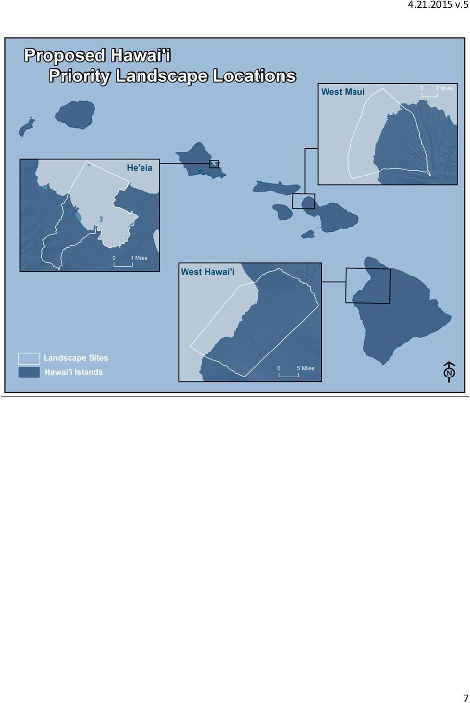
6 West Hawai i, West Maui, He eia Watershed (O'ahu) (Lead Agency or Organization: Pacific Islands LCC) Ridge to reef efforts to build resilience in the most vulnerable areas The three Hawaii locations chosen for this initiative have ongoing and active management schemes in place with participation from an extensive list of federal, state, and local government agencies as well as community and non-profit organizations. Each location is already designated a priority location by the State of Hawai i and NOAA. He eia is a NOAA Sentinel Site and the State is nominating it for inclusion in NOAA s National Estuarine Research Reserve System. Several local non-profits are leading conservation efforts in He eia which include stream and wetland restoration, invasive species eradication, and fishpond restoration. West Maui is a State of Hawai i and US Coral Reef Task Force designated priority area with a watershed restoration initiative led by a large, multi-stakeholder group including numerous federal agencies such as NOAA, FWS, NRCS, EPA, and USGS in partnership with the State, as well as community and local non-profit organizations. The State of Hawai i and the US Coral Reef Task Force have also designated South Kohala within West Hawai i as a priority area, which is a NOAAdesignated Sentinel Site location and Habitat Blueprint Focus Area. Priorities in West Hawai i include reef resilience, erosion and wildfire control, and dry forest restoration. West Maui and West Hawai i are also within National Marine Sanctuary boundaries. While each location has slightly different participants and focus, they all incorporate robust community engagement and multi-sectoral partnerships in addressing a range of resilience options. Much of the work is utilizing existing tools and services while using new science and tools to understand climate vulnerability and develop management options. In He eia, organizations are using the NOAA Sea Level Viewer, reef resilience studies, and various reef and terrestrial invasive species removal techniques while also identifying new assessments needs for flooding and sedimentation. West Maui has an ongoing Ridge-to-Reef effort that has utilized PICCC s analysis of projected vegetation changes under future climate scenarios as well as identifying key reef stressors, high erosion locations, and post-fire rehabilitation plans. West Hawai i is conducting similar reef resilience studies and erosion assessments while working to better prevent wildfire impacts, which will be exacerbated by climate change. Selection as one of the Resilient Lands and Waters areas will help coalesce the many efforts around specific climate change-related issues in areas of high vulnerability. The improved coordination and maps will aid in the identification of new partnership opportunities and more effectively and efficiently address resilience across this network of sites. It will also help prioritize which climate change impacts are the most widespread and of greatest concern. For additional information please contact: Jeff Burgett, [email protected],

7 7
8 PARTNERS These partner organizations have collaborated in the development of these Resilient Lands and Waters. These organizations will be in dialogue to develop more explicit strategies, maps and programs of work for these Resilient Lands and Waters within 18 months as laid out in the Climate and Natural Resources Priority Agenda ( s_natural_resources.pdf). Hawaii Partners (PICCC Charter Members) American Bird Conservancy Bishop Museum Hawai i Conservation Alliance Hawai i Wetland Joint Venture Kamehameha Schools National Park Service Inventory and Monitoring National Park Service Pacific West Region NOAA National Marine Fisheries Service NOAA NESDIS NCDC Climate Services Pacific Region NOAA Office of National Marine Sanctuaries NOAA Pacific Services Center Office of Hawaiian Affairs Pacific Science Association State of Hawai'i Department of Land and Natural Resources Division of Aquatic Resources State of Hawai i Department of Land and Natural Resources Division of Forestry and Wildlife The Nature Conservancy of Hawai i Office Trust for Public Lands Hawai i U.S. Army Garrison Hawai i Natural Resource Program U.S. Fish and Wildlife Service Ecological Services Pacific Islands Fish and Wildlife Office U.S. Fish and Wildlife Service Migratory Birds U.S. Fish and Wildlife Service National Wildlife Refuge System Hawaiian and Pacific Islands National Wildlife Refuges U.S. Fish and Wildlife Service Wildlife and Sport Fish Restoration Program U.S. Geological Survey Pacific Island Ecosystems Research Center University of Hawai i at Mānoa Center for Conservation Research and Training University of Hawai i at Mānoa Social Science Research Institute University of Hawai i at Hilo Office of Research Peninsular Florida LCC Steering Committee US Fish & Wildlife Service US Geological Survey National Park Service National Oceanic and Atmospheric Administration Department of Defense 8
 American Bird Conservancy Bishop Museum Hawai i Conservation Alliance Hawai i Wetland Joint Venture Kamehameha Schools National Park Service Inventory and")
9 Florida Fish & Wildlife Conservation Commission Florida Department of Agriculture and Consumer Services Florida Department of Transportation Southwest Florida Water Management District The Nature Conservancy Florida Wildlife Federation Florida Forestry Association Florida Farm Bureau Federation Wildlands Conservation Plum Creek Breedlove, Dennis & Associates, Inc. (Florida Land Council) Ken Passarella, and Associates, Inc. Family Lands Remembered, LLC Florida State University, Florida Natural Areas Inventory University of Florida, Center for Landscape Conservation Private Landowners Lakes Huron and Erie Coastal Wetlands (Saginaw Bay (MI) to Maumee River (OH/IN)) Interagency Groups: Upper Midwest and Great Lakes Landscape Conservation Cooperative; Great Lakes Restoration Initiative Habitat Committee; Great Lakes Wetlands Consortium Bi national Agencies: Environment Canada, Ontario Ministry of Natural Resources, Great Lakes Commission Federal Agencies: NOAA, USFWS, USGS, NPS, BIA, EPA State Agencies: WI, MN, IL, MI, OH NGOs: TNC, Ducks Unlimited, Audubon, NFWF Universities: University of MN, WI, MI, Oregon State, Grand Valley State, University of Notre Dame, Lake Superior State University, SUNY, University of Windsor, Central Michigan University Puget Sound/Snohomish River Watershed Coordinated Investment (CI) Approach: EPA, USGS, FEMA, NOAA, USFWS, ACOE, Washington State Puget Sound Partnership Floodplains by Design partnership-- Washington Department of Fish and Wildlife, Puget Sound Partnership, and The Nature Conservancy Sustainable Lands Strategy 9

Oregon. Climate Change Adaptation Framework
 Oregon Climate Change Adaptation Framework Oregon Environmental Quality Commission Climate Change Adaptation Framework Presentation at a glance: Purposes of the framework Participating agencies Climate
Peninsular Florida Landscape Conservation Cooperative. Charter. Background
 Charter Background The Peninsular Florida Landscape Conservation Cooperative (Conservation Cooperative) is part of a national network of Landscape Conservation Cooperatives (LCCs). LCCs are applied conservation
CHAPTER 2: APPROACH AND METHODS APPROACH
 CHAPTER 2: APPROACH AND METHODS APPROACH Given Hawaii s biological uniqueness on a global scale, the Comprehensive Wildlife Conservation Strategy (CWCS) recognizes the importance of protecting all native
Update on Ecosystem Services in the Federal Government. Kristin E. Skrabis Office of Policy Analysis U.S. Department of the Interior April 30, 2014
 Update on Ecosystem Services in the Federal Government Kristin E. Skrabis Office of Policy Analysis U.S. Department of the Interior April 30, 2014 Summary Ecosystem Services Report to the President Principles
The Marine Protected Area Inventory
 The Marine Protected Area Inventory New pictures Jordan Gass, Hugo Selbie and Charlie Wahle ESRI Ocean Forum November 6, 2013 Outline What is the MPA Inventory? Purpose Data How it s used Future directions
THE SECRETARY OF THE INTERIOR WASHINGTON
 THE SECRETARY OF THE INTERIOR WASHINGTON ORDER NO. 3336 Subject: Rangeland Fire Prevention, Management and Restoration Sec. 1 Purpose. This Order sets forth enhanced policies and strategies for preventing
Wetlands and Climate Change: Considerations for Wetland Program Managers
 Wetlands and Climate Change: Considerations for Wetland Program Managers Association of State Wetland Managers July 2015 1 Wetlands and Climate Change: Considerations for Wetland Program Managers Association
The North State: Implementing the California Water Action Plan February 24, 2014
 The North State: Implementing the California Water Action Plan February 24, 2014 The North State Water Alliance applauds Governor Brown s California Water Action Plan (Action Plan) and his call for comprehensive
SKAGIT COUNTY HABITAT IMPROVEMENT PLAN
 SKAGIT COUNTY HABITAT IMPROVEMENT PLAN Public Works Department Natural Resources Division August 2012 Mission To create and advance restoration strategies that support Skagit County goals for promoting
New York Sea Grant Strategic Plan
 New York Sea Grant Strategic Plan Introduction and Process This is the new strategic plan for New York Sea Grant (NYSG) for the years 2010-2013 as requested by the National Sea Grant Office. This plan
Policy & Management Applications of Blue Carbon. fact SHEET
 Policy & Management Applications of Blue Carbon fact SHEET Policy & Management Applications of Blue Carbon Coastal Blue Carbon - An Important Wetland Ecosystem Service Coastal Blue Carbon refers to the
COMPREHENSIVE PLAN SECTION B, ELEMENT 4 WATER RESOURCES. April 20, 2010 EXHIBIT 1
 COMPREHENSIVE PLAN SECTION B, ELEMENT 4 WATER RESOURCES April 20, 2010 EXHIBIT 1 ELEMENT 4 WATER RESOURCES TABLE OF CONTENTS 4.1 INTRODUCTION 4.2 GOALS AND POLICIES 4.2.A General Goals and Policies 1 4.2.B
Forest-Climate Working Group:
 Forest-Climate Working Group: Policy Platform 1 Forest-Climate Working Group: Policy Platform Endorsing Organizations American Bird Conservancy American Forest & Paper Association American Forest Foundation
Subactivity: Habitat Conservation Program Element: National Wetlands Inventory
 HABITAT CONSERVATION FY 29 BUDGET JUSTIFICATION Subactivity: Habitat Conservation Program Element: National Wetlands Inventory National Wetlands Inventory ($) FTE 27 4,7 2 28 Enacted 5,255 2 Fixed Costs
Fish and Wildlife. Service. FWS Funding
 Fish and Wildlife Service Mission The mission of the Fish and Wildlife Service is to work with others to conserve, protect, and enhance fish, wildlife, plants, and their habitats for the continuing benefit
Appendix D: Federal Agencies Hazard Mitigation Roles, Responsibilities, and Authorities
 Appendix D: Federal Agencies Hazard Mitigation Roles, Responsibilities, and Authorities Federal Agency and Web Address Hazard Mitigation Roles and Responsibilities Natural Hazards Mitigation Legal Authority
Flood Risk Management
 Flood Risk Management Value of Flood Risk Management Every year floods sweep through communities across the United States taking lives, destroying property, shutting down businesses, harming the environment
Flood Risk Management
 Flood Risk Management Value of Flood Risk Management Value to Individuals and Communities Every year floods sweep through communities across the United States taking lives, destroying property, shutting
Karuk Tribe Integrating Traditional Ecological Knowledge within Natural Resource Management
 Karuk Tribe Integrating Traditional Ecological Knowledge within Natural Resource Management Traditional ecological knowledge (TEK) plays a significant role in the Karuk Tribe s approach to natural resource
NAPA COUNTY WATERSHED SYMPOSIUM
 Planning, Building, and Environmental Services NAPA VALLEY GROWTH NAPA COUNTY WATERSHED SYMPOSIUM Plunging Forward May 15, 2015 1 YOU CAN T CROSS THE SEA MERELY BY STANDING AND STARING AT THE WATER. Rabindranath
$200 Billion. Ecosystem Services: The Gridlock Breaker. Four Types of Capital. Built Capital Social Capital Human Capital Natural Capital
 Ecosystem Services: The Gridlock Breaker Four Types of Capital A session of the 2012 Washington State APA Conference Olympia, Washington 0ctober 12, 2012 Doug Osterman, Steve Hughes Tracy Stanton, Dave
FRAMEWORK FOR THE NATIONAL SYSTEM OF MARINE PROTECTED AREAS OF THE UNITED STATES OF AMERICA
 ii FRAMEWORK FOR THE NATIONAL SYSTEM OF MARINE PROTECTED AREAS OF THE UNITED STATES OF AMERICA U.S. United States of America USOAP U.S. Ocean Action Plan (USOAP) USGS US Geological Survey WCPA/IUCN World
2013 Annual Report. Prepared by: Tim Breault, PFLCC Coordinator. 1 P age
 2013 Annual Report Prepared by: Tim Breault, PFLCC Coordinator 1 P age 2 P age Peninsular Florida Geography 3 P age Description The Peninsular Florida Landscape Conservation Cooperative (PFLCC) is in a
ESRI_UC_2015_No843_Integrating Flood Risk Management and Salmon Habitat Restoration_CampbellSW
 ESRI_UC_2015_No843_Integrating Flood Risk Management and Salmon Habitat Restoration_CampbellSW Advancing an integrated approach to flood risk management and habitat restoration planning in the Puget Sound
Perception and Reality. Where to Find Funding for Invasive Species Control Programs. Environmental Resource Specialist. Agenda. Area of Responsibility
 Perception and Reality Where to Find Funding for Invasive Species Control Programs Jim Bean Environmental Resource Specialist BASF Corporation Little funding is available for invasive species control programs
REQUEST FOR PROPOSAL (RFP) For Consultancy Services
 For Consultancy Services") National Environment & Planning Agency 10 & 11 Caledonia Avenue, Kingston 5, Jamaica W.I. Tel: (876) 754-7540 Fax: (876) 754-7595-6, toll free help-line: 1-888-991-5005 Website: http://www.nepa.gov.jm
National Environment & Planning Agency 10 & 11 Caledonia Avenue, Kingston 5, Jamaica W.I. Tel: (876) 754-7540 Fax: (876) 754-7595-6, toll free help-line: 1-888-991-5005 Website: http://www.nepa.gov.jm
GULF COAST VULNERABILITY ASSESSMENT: AN APPROACH TO ASSESS KEY DRIVERS OF ECOLOGICAL CHANGE IN GULF OF MEXICO ECOSYSTEMS AND SPECIES
 GULF COAST VULNERABILITY ASSESSMENT: AN APPROACH TO ASSESS KEY DRIVERS OF ECOLOGICAL CHANGE IN GULF OF MEXICO ECOSYSTEMS AND SPECIES Amanda Watson NGI/GRI, Mississippi State University [email protected]
NOAA NATIONAL SEA GRANT COLLEGE PROGRAM 2014 2017 STRATEGIC PLAN
 NOAA NATIONAL SEA GRANT COLLEGE PROGRAM 2014 2017 STRATEGIC PLAN Sustaining our nation s ocean, coastal and Great Lakes resources through university based research, communications, education, extension
Restoring Ecosystems. Ecosystem Restoration Services
 Restoring Ecosystems Ecosystem Restoration Services 2 Ecosystem Restoration Services AECOM s integrated approach sciencebased planning, with innovative design and execution delivers sustainable and cost-effective
Project Theory-Climate Change and Traditional Ecological Knowledge Adaption in the Klamath Basin
 Project Theory-Climate Change and Traditional Ecological Knowledge Adaption in the Klamath Basin Frank K. Lake Lead Science and TEK Mentor for project Education 1995 B.S. University of California, Davis.
Restoration Planning and Development of a Restoration Bank
 Restoration Planning and Development of a Restoration Bank Black Creek Pioneer Village, South Theatre 8:30 a.m. to 3:30 p.m. Habitat Restoration and Environmental Monitoring Projects Section Restoration
SEC. 4001. PURPOSE. SEC. 4002. DEFINITIONS. SEC. 4003. COLLABORATIVE FOREST LANDSCAPE RESTORATION PROGRAM.
 TITLE IV--FOREST LANDSCAPE RESTORATION SEC. 4001. PURPOSE. The purpose of this title is to encourage the collaborative, sciencebased ecosystem restoration of priority forest landscapes through a process
Federal Arctic Policy, Management, and Research Pat Pourchot
 Federal Arctic Policy, Management, and Research Pat Pourchot Special Assistant to the Secretary of the Interior for Alaska Affairs The Federal Players Major Departments/Agencies: Department of the Interior
Ecosystem Services in the Greater Houston Region. A case study analysis and recommendations for policy initiatives
 Ecosystem Services in the Greater Houston Region A case study analysis and recommendations for policy initiatives Ecosystem Services Ecosystems provide services through their natural processes that we
33 CFR PART 332 COMPENSATORY MITIGATION FOR LOSSES OF AQUATIC RESOURCES. Authority: 33 U.S.C. 401 et seq. ; 33 U.S.C. 1344; and Pub. L. 108 136.
 33 CFR PART 332 COMPENSATORY MITIGATION FOR LOSSES OF AQUATIC RESOURCES Authority: 33 U.S.C. 401 et seq. ; 33 U.S.C. 1344; and Pub. L. 108 136. Source: 73 FR 19670, Apr. 10, 2008, unless otherwise noted.
1 Overview introducing global issues and legal tools through local case studies. 2 Importance of legal protections for natural areas
 Warren G. Lavey [email protected] University of Illinois (USA) Online Course 2015 Environmental Policy: Legal Protections for Overview of 16 Lessons Lesson Topic Three key messages Sources of case studies
How To Manage Water Resources In The Yakima Basin
 Yakima Basin Integrated Water Resource Management Plan October 23, 2014 Presented by Derek Sandison, Director Office of Columbia River Photo Courtesy of Tom Ring Basin size: 6,155 sq. miles Population:
Submission by the United States of America to the UN Framework Convention on Climate Change Communication of U.S. Adaptation Priorities May 29, 2015
 Submission by the United States of America to the UN Framework Convention on Climate Change Communication of U.S. Adaptation Priorities May 29, 2015 Adaptation is a challenge for all Parties. In addition
Canal Water Quality Restoration in the Florida Keys: One More Piece of the Puzzle in the Overall Restoration of South Florida
 Canal Water Quality Restoration in the Florida Keys: One More Piece of the Puzzle in the Overall Restoration of South Florida George Neugent Monroe County Commissioner Mike Forster Islamorada Village of
Fisheries and Aquaculture in our Changing Climate
 Fisheries and Aquaculture in our Changing Climate Coastal communities, fishers and fish farmers are already profoundly affected by climate change. Rising sea levels, acid oceans, droughts and floods are
Appendix B REFERENCES
 Appendix B REFERENCES 2007 Field Reconnaissance Report of Bank Erosion Sites and Site Priority Ranking. Sacramento River Flood Control Levees, Tributaries and Distributaries American Red Cross. www.redcross.org
FLOOD PROTECTION AND ECOSYSTEM SERVICES IN THE CHEHALIS RIVER BASIN. May 2010. Prepared by. for the. 2010 by Earth Economics
 FLOOD PROTECTION AND ECOSYSTEM SERVICES IN THE CHEHALIS RIVER BASIN May 2010 Prepared by for the Execubve Summary The Chehalis Basin experienced catastrophic flooding in 2007 and 2009. In response, the
Protecting Floodplain. While Reducing Flood Losses
 Protecting Floodplain Natural and Beneficial i Functions While Reducing Flood Losses Jon Kusler Association of State Wetland Managers 518 872 1804; [email protected] Report available at: http://aswm.org/pdf_lib/nbf.pdf
China Protected Areas Leadership Alliance Project
 Strengthening Leadership Capacity for Effective Management of China s Protected Areas Executive Summary The (CPALAP) is a multi-year initiative launched in 2008 under a partnership between the China State
SECTION 9 SUMMARY OF COORDINATION, PUBLIC VIEWS AND COMMENTS
 SECTION 9 SUMMARY OF COORDINATION, PUBLIC VIEWS AND COMMENTS This page intentionally left blank. 9.0SUMMARY OF COORDINATION, PUBLIC VIEWS AND COMMENTS 9.1 PUBLIC OUTREACH AND PUBLIC INVOLVEMENT Public
DECISION DOCUMENT NATIONWIDE PERMIT 27
 DECISION DOCUMENT NATIONWIDE PERMIT 27 This document discusses the factors considered by the Corps of Engineers (Corps) during the issuance process for this Nationwide Permit (NWP). This document contains:
Chehalis River Basin Flood Damage Reduction 2013-2015 Capital Budget Approved by Legislature in June 2013
 Chehalis River Basin Flood Damage Reduction 2013-2015 Capital Budget Approved by Legislature in June 2013 1. Design alternatives for large capital flood projects (basinlevel water retention and Interstate
Office of Solid Waste and Emergency Response. ECO Update. The Role Of Natural Resource Trustees In The Superfund Process
 United States Environmental Protection Agency Office of Solid Waste and Emergency Response Publication 9345.0-05I March 1992 ECO Update Office of Emergency and Remedial Response Hazardous Site Evaluation
The Everglades & Northern Estuaries; St. Lucie River Estuary, Indian River Lagoon & Caloosahatchee Estuary. Water Flows & Current Issues
 The Everglades & Northern Estuaries; St. Lucie River Estuary, Indian River Lagoon & Caloosahatchee Estuary Water Flows & Current Issues Florida Governor Rick Scott August 20, 2013 Upper Chain of Lakes
Climate Change on the Prairie:
 Climate Change on the Prairie: A Basic Guide to Climate Change in the High Plains Region - UPDATE Global Climate Change Why does the climate change? The Earth s climate has changed throughout history and
Urban Stream Restoration Defining the Full Benefits of a Project. Warren C. High MACTEC Engineering and Consulting
 Urban Stream Restoration Defining the Full Benefits of a Project Warren C. High MACTEC Engineering and Consulting Economics in the Decision Process Return on Investment Willingness to Pay Municipal Growth
Using an All lands Framework for Conservation of Ecosystem Services
 Using an All lands Framework for Conservation of Ecosystem Services Robert Deal USDA Forest Service - PNW Research Station, Portland, OR Nikola Smith USDA Forest Service - Pacific Northwest Region, Portland,
AN INITIATIVE TO IMPROVE
 L OW E R C A R M E L R I V E R A N D L AG O O N F L O O D P L A I N R E S TO R AT I O N A N D E N H A N C E M E N T P R O J E C T AN INITIATIVE TO IMPROVE FLOOD PROTECTION RESTORE AND PROTECT RIPARIAN
Appendix J Online Questionnaire
 Appendix J Online Questionnaire In accordance with the Paperwork Reduction Act, this questionnaire was approved by the Office of Management and Budget (OMB). The OMB control number and expiration date
Watershed Program: A Little Known but Powerful Solution for Integrated Estuarine Restoration
 Watershed Program: A Little Known but Powerful Solution for Integrated Estuarine Restoration Cape Cod Water Resources Restoration Project (CCWRRP) Initial farmer, landowner, and municipal official discussions
Develop hazard mitigation policies and programs designed to reduce the impact of natural and human-caused hazards on people and property.
 6.0 Mitigation Strategy Introduction A mitigation strategy provides participating counties and municipalities in the H-GAC planning area with the basis for action. Based on the findings of the Risk Assessment
A Global View of Ecological Restoration and the Role of SER International
 A Global View of Ecological Restoration and the Role of SER International Presented by: George D. Gann Chair, SER International Board of Directors Executive Director, The Institute for Regional Conservation
Lower Crooked Creek Watershed Conservation Plan EXECUTIVE SUMMARY
 EXECUTIVE SUMMARY Project Background Located in southwestern Pennsylvania, Crooked Creek is a major tributary of the Allegheny River, entering near Ford City in Armstrong County. It is rich in natural
Coral Triangle Initiative (CTI) on Coral Reefs, Fisheries and Food Securities
 on Coral Reefs, Fisheries and Food Securities") 2008/MRCWG/022 Agenda Item: 10 Coral Triangle Initiative (CTI) on Coral Reefs, Fisheries and Food Securities Purpose: Information Submitted by: Indonesia 21 st Marine Resource Conservation Working Group
2008/MRCWG/022 Agenda Item: 10 Coral Triangle Initiative (CTI) on Coral Reefs, Fisheries and Food Securities Purpose: Information Submitted by: Indonesia 21 st Marine Resource Conservation Working Group
Creating Green Jobs within the Environment and Culture sector.
 Creating Green Jobs within the Environment and Culture sector. Matilda Skosana Environmental Programmes (ILO Definition): 1. DEFINITION OF GREEN JOB. Jobs are green when they help reduce negative environmental
ERP: Willamette-Ecosystem Services Project
 ERP: Willamette-Ecosystem Services Project Presented by Iris Goodman to NAS Sustainability R&D Forum October 17-18, 2007 Conserving ecosystem services through proactive decision-making making Linking Human
Integrated Restoration Prioritization
 Integrated Restoration Prioritization Habitat Restoration and Environmental Monitoring Projects Section Restoration Services Division Definition Restoration Prioritization is a process of combining various
SECTOR ASSESSMENT (SUMMARY): CLIMATE CHANGE. 1. Sector Performance, Problems, and Opportunities
: CLIMATE CHANGE. 1. Sector Performance, Problems, and Opportunities") Climate Resilience Sector Project (RRP TON 46351) Sector Road Map SECTOR ASSESSMENT (SUMMARY): CLIMATE CHANGE 1. Sector Performance, Problems, and Opportunities 1. Tonga is being affected by climate change,
Climate Resilience Sector Project (RRP TON 46351) Sector Road Map SECTOR ASSESSMENT (SUMMARY): CLIMATE CHANGE 1. Sector Performance, Problems, and Opportunities 1. Tonga is being affected by climate change,
Prioritizing Wetland and Stream Restoration and Protection Using Landscape Analysis Tools
 Prioritizing Wetland and Stream Restoration and Protection Using Landscape Analysis Tools The Environmental Law Institute recently completed A Handbook for Prioritizing Wetland and Stream Restoration and
3. The submittal shall include a proposed scope of work to confirm the provided project description;
 QIN Shoreline Master Program Project Summary The Shoreline Master Program (SMP) development process for the Quinault Indian Nation (QIN) includes the completion of inventory and analysis report with corresponding
Environmental Law Primer. Adapted from Vermont Law School s Environmental Law Primer for Journalists
 Environmental Law Primer Adapted from Vermont Law School s Environmental Law Primer for Journalists General Categories Command and Control Liability Disclosure Ecosystem and Place-based Programs Marketable
Restoring and protecting natural floodplains reduces flood losses and benefits the environment. Photo: USDA NRCS.
 The Multiple Benefits of Floodplain Easements: An Assessment of American Recovery and Reinvestment Act-Funded Emergency Watershed Protection Program Floodplain Easements in the Upper Mississippi River
Clean Water Services. Ecosystems Services Case Study: Tualatin River, Washington
 Viewed broadly, the concept of ecosystem services describes the many resources and services provided by nature. Typically, traditional planning and development practices do not adequately represent the
NATURAL RESOURCE RESTORATION LESSON PLAN Fix It!
 NATURAL RESOURCE RESTORATION LESSON PLAN Fix It! Theme Repairing Damaged Resources Links to Overview Essays and Resources Needed for Student Research http://oceanservice.noaa.gov/education/corals http://oceanservice.noaa.gov/topics/coasts/restoration/
GREAT BARRIER REEF. Climate Change Action Plan
 GREAT BARRIER REEF Climate Change Action Plan 2007 2011 Climate change is now recognised as the greatest long-term threat to the Great Barrier Reef. The Great Barrier Reef is internationally renowned as
Chapter 9. Selected Watershed Initiatives in the Great Basin Region
 Chapter 9 Selected Watershed Initiatives in the Great Basin Region The Great Basin contains vast areas of sparsely populated desert lands. Lacking an ocean drainage, the Great Basin is a hydrologic sink
Colorado Natural Heritage Program
 CNHP s mission is to preserve the natural diversity of life by contributing the essential scientific foundation that leads to lasting conservation of Colorado's biological wealth. Colorado Natural Heritage
Post-Flood Assessment
 Page 1 of 7 Post-Flood Assessment CHAPTER 4 AGENCY COORDINATION Agency coordination is an essential element for the operation of the flood management systems in the Central Valley. Due to the nature of
Strategic Land Conservation in the Gulf of Mexico Region
 Strategic Land Conservation in the Gulf of Mexico Region : Elizabeth Barber and Julia Weaver, Coordinators, Partnership for Gulf Coast Land Conservation Bob Stokes, Galveston Bay Foundation President and
Pay Later: The Cost of Inaction. Climate change will have a negative impact on many of the industries that 3500 3000 2500 2000 1500 1000 500 5.
 FACTS CONNECTICUT A M E R I C A N S E C U R I T Y P R O J E C T Pay Now, Pay Later: Connecticut The Environmental Protection Agency estimates that the cost of protecting Connecticut s coast from the potential
Michigan Wetlands. Department of Environmental Quality
 Department of Environmental Quality Wetlands are a significant component of Michigan s landscape, covering roughly 5.5 million acres, or 15 percent of the land area of the state. This represents about
EPA Trends for wastewater Treatment in California - 2011
 EPA S TECHNOLOGY NEEDS FOR THE WATER AND WASTEWATER INDUSTRY Nancy Stoner Acting Assistant Administrator U.S. EPA Office of Water International Emerging Technology Symposium Arlington, VA April 23rd, 2014
2015 Monarch Butterfly Conservation Fund Grant Slate
 2015 Monarch Butterfly Conservation Fund Grant Slate NFWF CONTACT Teal Edelen, Manager Central Regional Office [email protected] or 202-857-0166 Monarch caterpillar on milkweed ABOUT NFWF The National
Regulating Offshore Renewable Energy Leasing and Development
 Regulating Offshore Renewable Energy Leasing and Development Robert P. LaBelle Acting Associate Director Offshore Energy and Minerals Management Bureau of Ocean Energy Management, Regulation and Enforcement
Using the Carbon Market to Provide Financial Support for Coastal Restoration and Protection. fact SHEET
 Using the Carbon Market to Provide Financial Support for Coastal Restoration and Protection fact SHEET Using the Carbon Market to Provide Financial Support for Coastal Restoration and Protection Coastal
Interim Technical Guidelines for the Development of Environmental Management Plans for Underground Infrastructure Revised - July 2013.
 Interim Technical Guidelines for the Development of Environmental Management Plans for Underground Infrastructure Revised - July 2013 Rationale Underground infrastructure may be at risk from valley, streambank
Implementation Plan. Secretarial Order 3336 Rangeland Fire Prevention, Management, and Restoration
 Implementation Plan Secretarial Order 3336 Rangeland Fire Prevention, Management, and Restoration Page is intentionally blank U. S. Department of the Interior Deputy Secretary Michael L. Connor, on behalf
Waldo Canyon Fire. Mark Shea Watershed Planning Supervisor August 23, 2012
 Mark Shea Watershed Planning Supervisor August 23, 2012 Fire Started: Saturday June 23, 2012 Fire Progression June 23 2500 acres June 24 3600 acres June 25 4500 acres June 26 15622 acres June 27-28
Climate Adaptation and Preparedness
 Climate Adaptation and Preparedness Aaron Durnbaugh, Adaptation Coordinator & Deputy Commissioner, City of Chicago Department of Environment Rahm Emanuel, Mayor Climate Impact: Lake Michigan Decreased
Department of Defense MANUAL
 Department of Defense MANUAL NUMBER 4715.03 November 25, 2013 USD(AT&L) SUBJECT: Integrated Natural Resources Management Plan (INRMP) Implementation Manual References: See Enclosure 1 1. PURPOSE. In accordance