2015 Annual Operating Plan Fire Weather Forecasts and Services NWS Chicago/Romeoville
|
|
|
- Esmond Parsons
- 10 years ago
- Views:
Transcription
1 2015 Annual Operating Plan Fire Weather Forecasts and Services NWS Chicago/Romeoville Updated 10/29/15 CMS

2 I. INTRODUCTION The fire weather forecast and service program provides forecast, warning, and consultation services to local, state, and federal government agencies for the prevention, suppression, and management of forest and rangeland fires. The National Weather Service (NWS) Chicago/Romeoville will issue routine fire weather forecasts during the fall and spring seasons (see section 1 Routine Fire Weather Services for dates of each season) to support fire and land management activities. In addition to routine fire weather forecasts, NWS Chicago/Romeoville will issue spot (site-specific) forecasts using the guidelines in Section 3, under SITE SPECIFIC WILDLAND FIRE FORECASTS. II. SERVICE AREA AND ORGANIZATIONAL DIRECTORY NWS Chicago/Romeoville will issue routine forecasts for all 23 counties within its County Warning Area (CWA), during the spring and fall fire weather seasons. There are three federal users within the CWA; The Indiana Dunes National Lakeshore, the Midewin National Tallgrass Prairie and FermiLab. See appendices 1a through 1d for maps. The fire weather forecast (FWF) will have 23 individual groups, one for each county. Following is a list of important contacts: National Weather Service Chicago/Romeoville FermiLab (DOE) Casey Sullivan (Fire Weather Program Manager) Dave Shemanske Edward Fenelon (Meteorologist In Charge) PO Box 500 MS W. University Drive Batavia, IL Romeoville IL, (630) (815) (24 hour Internal) (630) (Cell) (815) (Fax) (630) (Fax) Indiana Dunes National Lakeshore (NPS) Midewin National Tallgrass Prairie Dan Morford (Fire Management Officer) Renee Thakali-Restoration Team Leader (219) (work); (219) (Cell) (815) Mary Lothschutz (AFMO) South State Route 53 (219) (work); (219) (Cell) Wilmington, IL Neal Mulconrey (815) /2136 (Office) (219) (work); (219) (cell) (815) (Fax) 1100 North Mineral Springs Road Porter, IN (219) (Fax) Eastern Area Fire Weather Program Manager -EACC Stephen Marien Mississippi National River and Recreation Area 111 East Kellogg Blvd, Suite 105 St Paul, MN (651) (Office); (402) (Cell); (651) (Fax)
 to support fire and land management activities.")
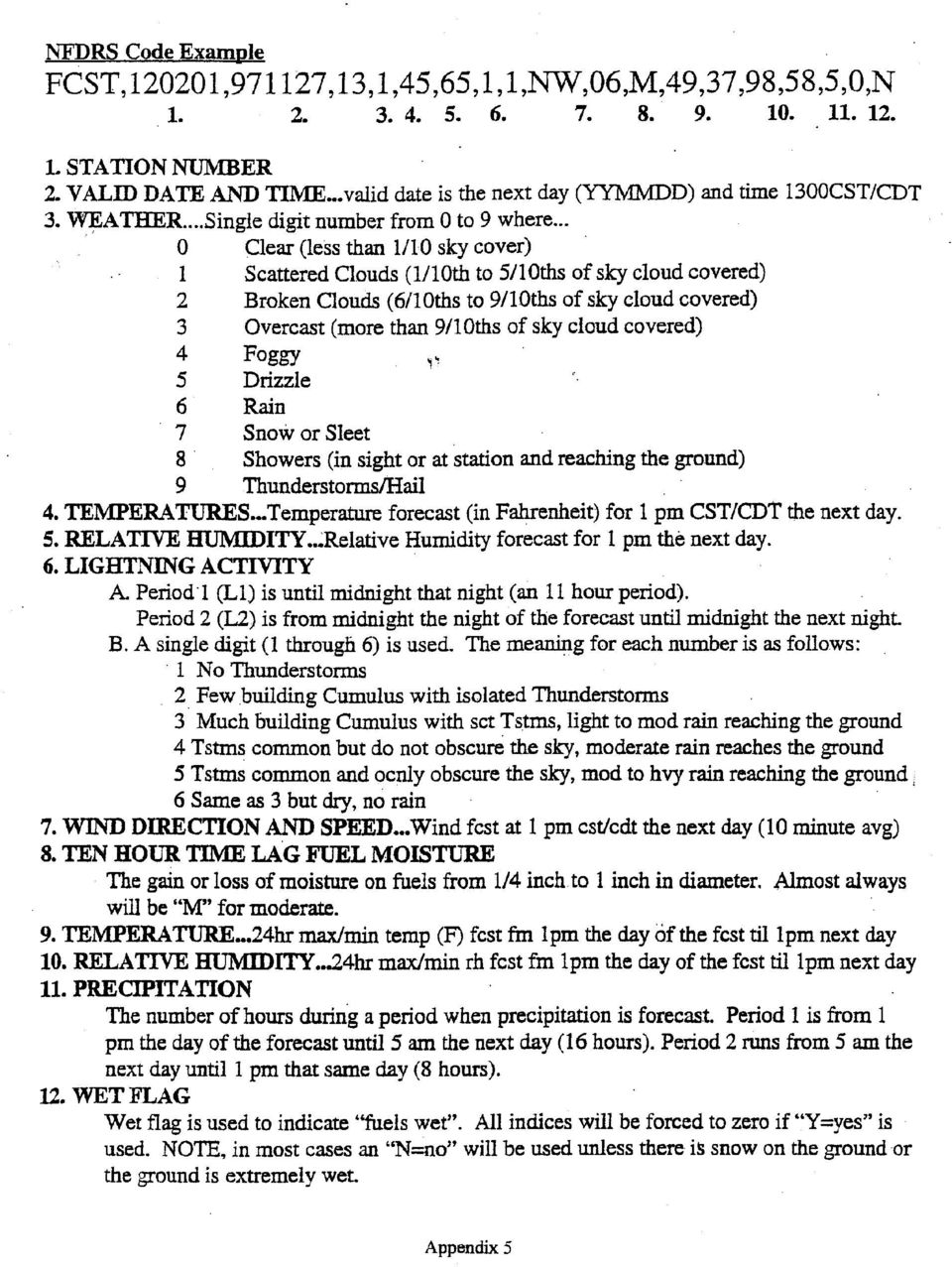
3 III. SERVICES PROVIDED BY THE NATIONAL WEATHER SERVICE 1) ROUTINE FIRE WEATHER SERVICES Routine fire weather forecasts will be issued daily during the Spring and Fall fire seasons. The narrative fire weather forecast will be issued by 6 am, 1030 am and 4 pm central time and issued under the product ID CHIFWFLOT and updated as necessary. A National Fire Danger Rating System (NFDRS) forecast will be issued for the Bailley station (RAWS site) at the Indiana Dunes around 1pm local time daily during the fire seasons under the product ID CHIFWMLOT. The Spring fire season will begin around March 1st and end around May 15th while the Fall fire weather season will begin around October 1st and end around December 15th. These dates are flexible based on the needs of the fire agencies and current weather conditions. The fire weather forecasts are issued using GFE, after producing the proper grids for the fire weather forecasts. Both the FWFLOT and FWMLOT (NFDRS forecast) can be created and issued from GFE. Instructions to create these grids can be found in Appendix 4. See Appendix 5 for a detailed listing of the forecast elements in the NFDRS forecast. Fire and land managers can access the fire weather forecasts from the NWS Chicago/Romeoville internet site: The narrative fire weather forecast (FWFLOT) will include a discussion of storm systems, fronts, etc. with a focus on the first two days but including systems through day five of the forecast. The following specific elements will be forecast through the first 48 hours: CLOUD COVER PRECIP TYPE CHANCE OF PRECIP MAX TEMP (24HR TREND) MIN RH (%) MIN TEMP (24HR TREND) MAX RH (%) 20 FT WIND AM (MPH) 20 FT WIND PM (MPH) PEAK WIND GUSTS (MPH) PRECIP AMOUNT (IN) 11 AM MIXING HGT (FT) MAX MIXING HGT (FT) 1700 FT MIXING TEMP TRANSPORT WND (KTS) VENT RATE (KT-FT) VENT RATE CATEGORY HAINES INDEX

4 Beyond 48 hours, the narrative fire weather forecast will contain a general extended forecast for days 3 through 7. Included in the extended forecast will be winds at the 20 foot level). See appendix 2 for a FWFLOT template with all required elements and fields. Certain headlines which are important for fire weather are included in the FWF. They include any heat advisories, watches or warnings; and high wind watches or warnings or wind advisories as well as fire weather watches and red flag warnings. No other headlines are included in the FWF. The Ventilation Rate ( VENT RATE in the FWF) is a dispersion variable that fire and land managers use to determine how well the atmosphere will carry away smoke. It is a simple multiplication of the transport wind speed times the mixing height (same as the inversion). For example, if the transport wind speed is 20 knots and the mixing height is 1,000 feet, the ventilation rate is 20,000 kt/ft. In the FWF, only the vent rate max (highest value for the 12 hour period) is included. The scale for the ventilation rate and the corresponding descriptor (or category) is listed below. In the FWF, only the highest category (for the 12 hour period) is included. Knots can be converted to mph by multiplying by approximately Mph can be converted to knots by multiplying by approximately Less than 40,000 knot/feet Poor 40,000 to 60,000 Fair 60,000 to 100,000 Good 100,000 to 150,000 Very Good 150,000 or greater Excellent The 1700 foot mixing temp ( 1700 FT MIXING TEMP in the FWF) is the surface temperature needed to be reached for the mixing height to reach 1700 feet. For example, if the forecast 1700 foot mixing temperature is 70 degrees and the high temperature is expected to reach 80 degrees, the mixing height is expected to be near or passing through (rising) 1700 feet when the surface temperature reaches 70 degrees. Conversely, if the 1700 foot mixing temperature is 70 degrees and the high temperature is only expected to reach 65 degrees, than the mixing height is not expected to reach 1700 feet and will be below 1700 feet for the entire day. It should be noted that these parameters are forecasts and may become unrepresentative if conditions change from the forecast(s). 2) SITE SPECIFIC WILDLAND FIRE FORECASTS Spot (site-specific) forecasts will be issued under the following criteria: A) To any agency for an ongoing wildfire.

5 B) Upon request of any federal official who represents that the spot forecast is required under the terms of the Interagency Agreement for Meteorological Services (NWS Instruction ). C) Upon request of any state, tribal, or local official who represents that the spot forecast is required to carry out their wildland fire management responsibilities in coordination with any federal land management agency participating in the Interagency Agreement for Meteorological Services (NWS Instruction ). D) Upon request of any public safety official who represents that the spot forecast is essential to public safety. A "public safety official" is an employee or contract agent of a government agency at any level (federal, state, local, tribal, etc.) charged with protecting the public from hazards including wildland fires of whatever origin and/or other hazards influenced by weather conditions such as hazardous material releases. A spot forecast can be issued to any federal agency for a prescribed burn. However, spot forecasts can only be issued to non-federal agencies when the prescribed burn is essential to public safety or when federal resources are involved with the non-federal agency. The requesting agency will provide a current weather observation at or near the location of the fire (an AWOS or ASOS can be used if representative). Spot forecasts should contain the same elements included in the routine narrative forecast as well as any additional elements needed by the requesting agency. The requesting agency will submit a spot forecast request from our internet page at the following link: Instructions for fire and land managers to request a spot forecast can be found in Appendix 6. The forecaster will complete the forecast through GFE using the instructions in Appendix 7a. If the forecast cannot be completed through GFE, the forecast can still be completed on the internet page above. These instructions can be found in Appendix 7b. The second way to request a spot forecast is for the requesting agency to fill out WS FORM D-1 (see last appendix). Once the requesting agency has filled out this form, they can fax a copy to our office and should call us to make sure we have received it. The forecasters can then use the spot forecast form (see Appendix 3) to complete the spot forecast. This form can be faxed back to the requesting agency or the forecast can be given over the phone. During service backup (primary for NWS Lincoln, secondary for NWS Milwaukee), NWS Chicago/Romeoville will complete spot forecasts requests using GFE. Alerts for spot forecasts will need to be added to the AWIPS workstation s alarms (CHISTQILX for Lincoln and MKESTQMKX for Milwaukee). If the spot forecasts cannot be completed using GFE, they will be completed using the websites and instructions in Appendix 7b.
 Upon request of any public safety official who represents that the spot forecast is essential to public safety.")
6 3) FIRE WEATHER WATCHES, RED FLAG WARNINGS In coordination/collaboration with local, state, and federal fire managers, fire weather watches and red flag warnings will be issued for any or all counties within NWS Chicago/Romeoville CWA based on the following local criteria: 1) Sustained 20 foot winds of 20 mph or higher. 2) Afternoon relative humidity less than 25%. 3) 10 hour fuel moisture at 8% or less for one day. All three criteria must be met (or expected to be met) for the issuance of a fire weather watch or red flag warning. Both products are issued under the same product ID, CHIRFWLOT. Fire weather watches and red flag warnings are issued year-round, not just during the fire seasons. They also are to be mentioned in the hazardous weather outlook. Forecasters should contact fire managers before issuing a fire weather watch or red flag warning for two important reasons; first, to gain knowledge of current fuel moisture levels and second, a watch or warning places restrictions on fire management programs. Coordination should be two way and fire managers should also contact NWS Chicago/Romeoville when conditions are critically dry. See LOT Supplement to NDS " for more information on fire weather watches and red flag warnings. Fire weather watches and red flag warnings, when in effect, can be found at this link, IV. WILDLAND FIRE AGENCY RESPONSIBILITIES The Indiana Dunes will maintain the Bailley weather station (a RAWS site) with telephone access so NWS Chicago/Romeoville can dial in and access current weather observations and issue the NFDRS (FWMLOT) forecast. Without access to a current weather observation, NWS Chicago/Romeoville can suspend issuance of the NDFRS forecast. All fire agencies are required to provide a current weather observation for spot forecasts for both prescribed burns and ongoing wildland fires. They should provide as much information about the fire and location as possible. Fire agencies should provide feedback to NWS Chicago/Romeoville about positive and negative aspects of the fire weather forecasts and services. Fire and land managers should call NWS Chicago/Romeoville when fuels start or are expected to become critically dry. This information is very important when deciding to issue a fire weather watch or red flag warning.

7 V. JOINT RESPONSIBILITIES NWS Chicago/Romeoville will have sole fire weather forecast and service responsibility for its 23 county warning area (CWA). NWS ILX (Lincoln, Illinois) will provide primary backup services and NWS MKX (Milwaukee) will provide secondary backup services if NWS Chicago/Romeoville cannot issue forecasts or other services. NWS Chicago/Romeoville provides primary service backup for NWS Lincoln (ILX) and secondary service backup for NWS Milwaukee (MKX). NWS Green Bay (GRB) provides primary service backup for NWS Milwaukee (MKX). See Service Backup Manual for more information. Contacts for these offices: National Weather Service Lincoln Illinois (ILX) Pat Bak (Fire Weather Program Manager) 24 hour phone (to reach a forecaster) (217) National Weather Service Milwaukee/Sullivan (MKX) Mark Gehring (Fire Weather Program Manager) 24 hour phone (to reach a forecaster) (262)
 provides primary service backup for NWS Milwaukee (MKX). See Service Backup Manual for more information.")

8 Appendix 1a


9 Appendix 1b

10

11

12 FIRE WEATHER PLANNING FORECAST FOR NORTHERN IL AND NORTHWEST IN NATIONAL WEATHER SERVICE CHICAGO/ROMEOVILLE IL 600 AM CST TUE MAR RED FLAG WARNING OR FIRE WEATHER WATCH HEADLINE (LOCATION & TIME INCLUDED) (AS NEEDED)....DISCUSSION... (Manually added by forecaster) ILZ COOK- INCLUDING THE CITIES OF CHICAGO 600 AM CST TUE MAR RED FLAG WARNING OR FIRE WEATHER WATCH HEADLINE (LOCATION & TIME INCLUDED) (AS NEEDED)... CLOUD COVER PRECIP TYPE CHANCE OF PRECIP MAX TEMP (24HR TREND) MIN RH (%) MIN TEMP (24HR TREND) MAX RH (%) 20 FT WIND AM (MPH) 20 FT WIND PM (MPH) PEAK WIND GUSTS (MPH) PRECIP AMOUNT (IN) 11 AM MIXING HGT (FT) MAX MIXING HGT (FT) 1700 FT MIXING TEMP TRANSPORT WND (KTS) VENT RATE (KT-FT) VENT RATE CATEGORY HAINES INDEX.FORECAST FOR DAYS 3 THOUGH 7 (WINDS ARE 20 FT LEVEL) $$ TONIGHT WED WED NIGHT THU Appendix 2
 MIN RH (%) MIN TEMP (24HR TREND) MAX RH (%) 20 FT WIND AM (MPH) 20 FT WIND PM (MPH) PEAK WIND GUSTS (MPH) PRECIP AMOUNT (IN) 11 AM")
13 PRESCRIBED BURN/SPOT WEATHER FORECAST Date and Time Period of Burn Location Mixing Height Feet AGL (must be at least 1600 for burns at Indiana Dunes and Midewin) Transport wind speed Knots (average wind speed in the mixed layer) Today Tonight Tomorrow Max/Min Temp Min/Max RH Wind Speed (MPH) Wind Direction Cloud Cover Precipitation Remarks (especially concerning any wind shifts, fronts, etc.) Indiana Dunes Midewin FermiLab Fire Manager Cell Fire Manager Cell Fire Manger Cell (219) (815) (630) Fax (219) Fax (815) Fax (630) Appendix 3
 Indiana Dunes Midewin FermiLab Fire Manager Cell Fire Manager Cell Fire Manger Cell (219) 246-6965 (815) 922-2502 (630) 399-6167 Fax (219)")
14 Fire Weather Using IFPS/GFE Creating the FWF 1) Change to Fire Weather Element Group, Click Weather Elements Group >> FireWx 2) Populate FireWx Grids Click Populate >> PopulateFireWx Check data to make sure it is reasonable and consistent 3) Save the Grids then Publish by LEFT CLICKING ON GROUPS, SELECT FIREWX 4) Create the FWF, Products >> Formatter Launcher, then Products >> FWF then Run Formatter. 5) QC the data, check to make sure there is no missing data, add the Discussion, then transmit. Creating the FWM 1) Change to Fire Weather Element Group, Click Weather Elements Group >> FireWX 2) FireWx grids should be present from morning populating, if not, complete step 2 above. QC and/or update FireWx grids. Check thunderstorm data (if any) in the LAL grids. 3) Create the FWM, Products >> Formatter Launcher, then Products >> FWM then Run Formatter. 4) QC and transmit. If the Populate_Fire_Wx script fails, the data can be manually populated from any of the model data. Make sure to publish the grids to official before creating the FWF or FWM. Appendix 4
 Change to Fire Weather Element Group, Click Weather Elements Group >> FireWX 2) FireWx grids should be present from morning populating, if not, complete step 2 above.")
15
16 Instructions for Fire and Land Managers to request an NWSSpot Internet spot forecast 1) To start, go to the following link from the NWS Chicago/Romeoville web page: 2) Click on Submit a new Spot Forecast. 3) Complete the request by filling in all known parameters. All parameters in red are REQUIRED for the spot forecast request. Use decimal form for the Lat/Lon. 4) Current weather observation(s) near or at the burn location are required for a spot forecast. 5) In the lower left, choose the weather elements needed and whether the forecast is for today, tonight or tomorrow (or all three). In the remarks section, include any important information that will assist the forecasters or any questions. For example, burn location is one mile from I-55; burn location is 3 blocks from Lake Michigan and a few hundred feet from residential homes. 6) When finished, click on submit forecast. If any fields are left blank, another page will appear requesting the information. If the missing information is not required, the request can go through. 7) After submitting the spot forecast, the name of the request will show up on the web page in step 1. On the right, the status will show pending. It will generally take the forecaster 30 to 45 minutes to complete the request. It may be helpful to call the NWS Chicago to make sure the forecaster has received the spot forecast request. 8) Once the spot forecast has been issued, the status will show Completed. If Question appears, this means the forecaster has requested more information about the request. Once the status shows complete, click on complete, the spot forecast will appear. Appendix 6
 In the lower left, choose the weather elements needed and whether the forecast is for today, tonight or tomorrow (or all three).")
17 Instructions for forecasters to complete an NWSSpot Internet Spot Forecast Request using GFE/Formatter Launcher 1) The spot forecast request will alarm in on the Public and Aviation AWIPS workstations as CHISTQLOT. (Alarms for CHISTQILX for NWS Lincoln and MKESTQMKX for NWS Milwaukee will need to be added to your workstation while in service backup). 2) Create/update (as needed) the fire weather grids and publish the grids. 3) Open the formatter launcher, select FWS, and click on the run formatter icon. 4) A "Select Spot Forecast Values" GUI pops up. Select the name of the spot forecast request you wish to complete. Select the product issuance time (select a time closest to the current time). Select your name, click on OK. 5) An "Input Info Values" GUI pops up. Click on OK. 6) The spot forecast will be generated in the formatter launcher. Type in a discussion on top of the forecast. Make sure to check the remarks section of the STQ (spot forecast request) and answer/address any questions in the discussion section of the spot forecast. Click on transmit. 7) Check the spot forecast internet page (link below) and verify it made it to the internet (this will take a couple of minutes). Once it's there, you are done. 8) Please print a copy of the forecast and leave in focal point s mailbox. Appendix 7a
 A \"Select Spot Forecast Values\" GUI pops up. Select the name of the spot forecast request you wish to complete. Select the product issuance time (select a time closest to the current time).")
18 Instructions for forecasters to complete an NWSSpot Internet Spot Forecast Request through the NWSSpot Webpage 1) The spot forecast request will alarm in on the Public and Aviation AWIPS workstations as CHISTQLOT. (Alarms for CHISTQILX for NWS Lincoln and MKESTQMKX for NWS Milwaukee will need to be added to your workstation while in service backup). 2) Go to the following webpage (also linked off of our fire weather page). Click on the name of the forecast that was alarmed (should say PENDING in the status column to the right). Chicago/Romeoville (LOT) Lincoln (ILX) Milwaukee (MKX) 3) After you click on the name of the forecast, make sure there is a current observation and that it looks accurate. 4) Scroll down the page and click on initialize forecast. This takes you to another page, click on the Initialize Forecast button to initialize the forecast. 5) Click on edit forecast. Edit the forecast in the window and include all parameters that were requested. (Smoke dispersion refers to mixing height and transport winds). 6) Choose a duration the forecast will be valid for (above the edit area). 7) Save the edits. 8) Send the forecast. You will be prompted Are you sure? 9) Once the forecast has been sent, it will alert in on the Public and Aviation AWIPS workstations as CHIFWSLOT. The user that originally requested the forecast can now go back to the webpage above to get the completed spot forecast and the status will say COMPLETED. 10) Please print a copy of the forecast and leave in focal point s mailbox. Appendix 7b
 http://spot.nws.noaa.gov/cgi-bin/spot/spotmon?site=lot Lincoln (ILX) http://spot.nws.noaa.gov/cgi-bin/spot/spotmon?site=ilx Milwaukee (MKX) http://spot.nws.noaa.gov/cgi-bin/spot/spotmon?site=mkx 3) After you click on the name of the forecast, make sure there is a current observation and that it looks accurate.")
19

20

Mixing Heights & Smoke Dispersion. Casey Sullivan Meteorologist/Forecaster National Weather Service Chicago
 Mixing Heights & Smoke Dispersion Casey Sullivan Meteorologist/Forecaster National Weather Service Chicago Brief Introduction Fire Weather Program Manager Liaison between the NWS Chicago office and local
6.9 A NEW APPROACH TO FIRE WEATHER FORECASTING AT THE TULSA WFO. Sarah J. Taylor* and Eric D. Howieson NOAA/National Weather Service Tulsa, Oklahoma
 6.9 A NEW APPROACH TO FIRE WEATHER FORECASTING AT THE TULSA WFO Sarah J. Taylor* and Eric D. Howieson NOAA/National Weather Service Tulsa, Oklahoma 1. INTRODUCTION The modernization of the National Weather
A Mariner s Guide to Marine Weather Services Great Lakes
 A Mariner s Guide to Marine Weather Services Great Lakes U.S. DEPARTMENT OF COMMERCE National Oceanic and Atmospheric Administration National Weather Service NOAA PA 98053 Introduction Few people are affected
NOAA s National Weather Service Milwaukee/Sullivan
 NOAA s National Weather Service Milwaukee/Sullivan Marcia Cronce Meteorologist, Aviation Focal Point August 2014 weather.gov/milwaukee NWS Part of the Federal Government DOC - Department of Commerce NOAA
weather information management system / remote automated weather station
 weather information management system / remote automated weather station (wims/raws) OpERATIONS GUIDE wyoming blm June 2010 Table of Contents INTRODUCTION... ROLES AND RESPONSIBILITIES... A. District Manager...
Department of Commerce National Oceanic & Atmospheric Administration National Weather Service
 Department of Commerce National Oceanic & Atmospheric Administration National Weather Service NATIONAL WEATHER SERVICE WESTERN REGION SUPPLEMENT 17-2003 APPLICABLE TO NWSI 10-701 MARCH 16, 2015 Operations
Texas Department of Public Safety Texas Division of Emergency Management. Texas State Operations Center
 Texas Department of Public Safety Texas Division of Emergency Management Texas State Operations Center Situation Awareness Brief Saturday, October 26 th 2013 As of 0900 CDT Tropical Weather Outlook Incidents
Studying Topography, Orographic Rainfall, and Ecosystems (STORE)
") Studying Topography, Orographic Rainfall, and Ecosystems (STORE) Basic Lesson 3: Using Microsoft Excel to Analyze Weather Data: Topography and Temperature Introduction This lesson uses NCDC data to compare
Studying Topography, Orographic Rainfall, and Ecosystems (STORE) Basic Lesson 3: Using Microsoft Excel to Analyze Weather Data: Topography and Temperature Introduction This lesson uses NCDC data to compare
Basics of weather interpretation
 Basics of weather interpretation Safety at Sea Seminar, April 2 nd 2016 Dr. Gina Henderson Oceanography Dept., USNA [email protected] Image source: http://earthobservatory.nasa.gov/naturalhazards/view.php?id=80399,
EAST BAY REGIONAL PARK DISTRICT FIRE DEPARTMENT POINT PINOLE GRASSLAND RESTORATION PRESCRIBED FIRE AND SMOKE MANAGEMENT PLAN
 EAST BAY REGIONAL PARK DISTRICT FIRE DEPARTMENT POINT PINOLE GRASSLAND RESTORATION PRESCRIBED FIRE AND SMOKE MANAGEMENT PLAN February 11, 2014 TABLE OF CONTENTS Section 1 REVIEW AND APPROVAL 2 Section
Networking Break 3:00 pm 3:30 pm
 Networking Break 3:00 pm 3:30 pm Sponsored by: Track D: Claims Technology & Innovation Forensic Meteorology: How Weather Experts, Advanced Data and Computer Models Are Now Being Used For Claims Investigations
URGENT - WEATHER MESSAGE NATIONAL WEATHER SERVICE MELBOURNE FL 402 AM EST MON JAN 6 2014
 URGENT - WEATHER MESSAGE...FREEZE AND HARD FREEZE WARNINGS IN EFFECT FOR PORTIONS OF EAST CENTRAL FLORIDA TONIGHT......LAKE WIND ADVISORY IN EFFECT FOR PORTIONS OF EAST CENTRAL FLORIDA THIS AFTERNOON...
PRESCRIBED FIRE PLAN
 Element 1: Signature Page PRESCRIBED FIRE PLAN ADMINISTRATIVE UNIT NAME(S): PRESCRIBED FIRE NAME: Prescribed Fire Unit (Ignition Unit): PREPARED BY: Name (print): Qualification/Currency: Signature: Date:
Weather Briefing for Southeast Texas October 24 th, 2015
 Weather Briefing for Southeast Texas October 24 th, 2015 Dangerous Flash Flood Event Saturday through Sunday 8:16 AM Overview Ongoing: record deep moisture in place, elevated seas, rip currents, high surf,
How To Find Out If The Winds From The Oak Ridge Site Are Calm
 EVALUATING THE WIND DATA FROM THE AUTOMATED SURFACE OBSERVING SYSTEM IN OAK RIDGE, TENNESSEE - IS KOQT THE CALMEST SITE IN THE US? Thomas E. Bellinger, CCM Y-12 National Security Complex Oak Ridge, Tennessee
Texas Department of Public Safety Texas Division of Emergency Management. Texas State Operations Center
 Texas Department of Public Safety Texas Division of Emergency Management Texas State Operations Center Situation Awareness Brief Saturday, July 20 th 2013 As of 0900 CDT Tropical Weather Outlook For the
Emergency Management is responsible for coordinating the City of Houston s preparation for and response to emergency situations.
 CITY OF HOUSTON Office of Emergency Management October 2004 Emergency Management is responsible for coordinating the City of Houston s preparation for and response to emergency situations. Houston is exposed
RE: James vs. ABC Company Greentown, NJ D/A: February 20, 2011
 PO Box 7100 Hackettstown, NJ 07840 Phone: 1 800 427 3456 Fax: 908-850-8664 http://www.weatherworksinc.com June 16, 2012 Attn: John Doe Law Offices of John Doe 123 Fourth Street Smithtown, NJ 04506 RE:
IBM Big Green Innovations Environmental R&D and Services
 IBM Big Green Innovations Environmental R&D and Services Smart Weather Modelling Local Area Precision Forecasting for Weather-Sensitive Business Operations (e.g. Smart Grids) Lloyd A. Treinish Project
South Dakota Severe Weather Awareness Week April 22nd through 26th
 National Weather Service Aberdeen, South Dakota April 2013 Inside this issue: Severe Weather Awareness Impact Based Warnings Impact Based Warnings (cont) Record Cold March Record Cold March (cont) Seasonal
The Anatomy of a Forecast
 The Anatomy of a Forecast The Met Service issues forecasts for sky condition, precipitation probability, wind, seas state and temperature on a routine basis. Because the weather is always changing, the
A SEVERE WEATHER CLIMATOLOGY FOR THE WILMINGTON, NC WFO COUNTY WARNING AREA
 A SEVERE WEATHER CLIMATOLOGY FOR THE WILMINGTON, NC WFO COUNTY WARNING AREA Carl R. Morgan National Weather Service Wilmington, NC 1. INTRODUCTION The National Weather Service (NWS) Warning Forecast Office
WIMS TechNote-2010-02
 WIMS TechNote-2010-02 Fire and Aviation Management Staff Date: November 20, 2010 System: Subject: Purpose: Contact: WIMS WXML Web Services Document New WIMS Web Services Fire and Aviation Management Applications
Technical Attachment. The National Weather Service Estimated Actual Velocity Radar Tool. Ken Falk WFO Shreveport, Louisiana
 SRH STSD 2007-03 October 2007 Technical Attachment The National Weather Service Estimated Actual Velocity Radar Tool 1. Introduction Ken Falk WFO Shreveport, Louisiana A radar analysis tool has been introduced
Activity 1 Reading Universal Time Level 2 http://www.uni.edu/storm/activities/level2/index.shtml
 Activity 1 Reading Universal Time Level 2 http://www.uni.edu/storm/activities/level2/index.shtml National Science Education Standards: As a result of activities in grades 5-8, all students should develop
Improved Warnings for Natural Hazards: A Prototype System for Southern California
 Improved Warnings for Natural Hazards: A Prototype System for Southern California Yehuda Bock Research Geodesist Scripps Institution of Oceanography University of California San Diego, La Jolla, Calif.
Estação Meteorológica sem fio VEC-STA-003
 Estação Meteorológica sem fio VEC-STA-003 The Weatherwise Instruments professional touch-screen weather station is designed for easy everyday use and fits right into any home or office. The indoor base
RISD Hurricane Preparedness
 RISD Hurricane Preparedness Hurricane It is the policy of RISD to view each hurricane threat as an extremely hazardous condition. As such, our goal is to minimize the risk to personnel consistent with
INITIAL ATTACK DISPATCH CENTER - COMPLEXITIES
 INITIAL ATTACK DISPATCH CENTER - COMPLEXITIES A dispatch center s complexity is determined by the program complexity of the units supported by that dispatch center. A unit s program complexity is computed
8B.6 A DETAILED ANALYSIS OF SPC HIGH RISK OUTLOOKS, 2003-2009
 8B.6 A DETAILED ANALYSIS OF SPC HIGH RISK OUTLOOKS, 2003-2009 Jason M. Davis*, Andrew R. Dean 2, and Jared L. Guyer 2 Valparaiso University, Valparaiso, IN 2 NOAA/NWS Storm Prediction Center, Norman, OK.
Anyone Else Notice That Its Been Windy Lately?
 National Weather Service Aberdeen, South Dakota January 2014 Inside this issue: Has it Been Windy Lately or What? 2013 Year in Review 2013 Year in Review (cont.) 1 2 3 Has it Been Windy Lately or What?
Climate of Illinois Narrative Jim Angel, state climatologist. Introduction. Climatic controls
 Climate of Illinois Narrative Jim Angel, state climatologist Introduction Illinois lies midway between the Continental Divide and the Atlantic Ocean, and the state's southern tip is 500 miles north of
Winds. Winds on a weather map are represented by wind barbs; e.g., Notes:
 Winds Winds on a weather map are represented by wind barbs; e.g., flag half flag pennant wind direction The wind is blowing from the side with the flags and pennants (think an arrow with feathers) Speeds
2015 CRAIG INTERAGENCY FIRE MANAGEMENT GROUP (CIFMG) ANNUAL OPERATING PLAN
 ANNUAL OPERATING PLAN") 2015 CRAIG INTERAGENCY FIRE MANAGEMENT GROUP (CIFMG) ANNUAL OPERATING PLAN Craig Interagency Dispatch Center (CRC) Bureau of Land Management () Northwest District, Including Little Snake (LSD), Kremmling
2015 CRAIG INTERAGENCY FIRE MANAGEMENT GROUP (CIFMG) ANNUAL OPERATING PLAN Craig Interagency Dispatch Center (CRC) Bureau of Land Management () Northwest District, Including Little Snake (LSD), Kremmling
1. a. Surface Forecast Charts (USA and Ontario and Quebec) http://www.rap.ucar.edu/weather/
 http://www.rap.ucar.edu/weather/") COMPUTER ASSISTED METEOROLOGY Frank Pennauer This contribution gives the available computer data sources, how to access them and use this data for predicting Soaring weather conditions will be discussed
COMPUTER ASSISTED METEOROLOGY Frank Pennauer This contribution gives the available computer data sources, how to access them and use this data for predicting Soaring weather conditions will be discussed
Spatial Tools for Wildland Fire Management Planning
 Spatial Tools for Wildland Fire Management Planning M A. Finney USDA Forest Service, Fire Sciences Laboratory, Missoula MT, USA Abstract Much of wildland fire planning is inherently spatial, requiring
MIAMI-SOUTH FLORIDA National Weather Service Forecast Office http://www.weather.gov/miami
 MIAMI-SOUTH FLORIDA National Weather Service Forecast Office http://www.weather.gov/miami November 2014 Weather Summary Cooler and Drier than Normal December 1, 2014: Cooler than normal temperatures was
CRS 610 Ventura County Flood Warning System Website
 CRS 610 Ventura County Flood Warning System Website Purpose This document gives instructions and a description of the information available via the Ventura County Watershed Protection District s (VCWPD)
Storms Short Study Guide
 Name: Class: Date: Storms Short Study Guide Multiple Choice Identify the letter of the choice that best completes the statement or answers the question. 1. A(n) thunderstorm forms because of unequal heating
P3.8 INTEGRATING A DOPPLER SODAR WITH NUCLEAR POWER PLANT METEOROLOGICAL DATA. Thomas E. Bellinger
 P3.8 INTEGRATING A DOPPLER SODAR WITH NUCLEAR POWER PLANT METEOROLOGICAL DATA Thomas E. Bellinger Illinois Emergency Management Agency Springfield, Illinois 1. INTRODUCTION A Doppler sodar owned by the
Network emanger Basic User Guide. Connecting To Your Phone System
 Network emanager Basic User Guide Page 1 Network emanger Basic User Guide Connecting To Your Phone System Double-click on the Network emanager icon located on the desktop. Log in using the following credentials:
CENTRAL TEXAS COLLEGE SYLLABUS FOR AIRP 1307 AVIATION METEOROLOGY Semester Hours Credit: 3
 CENTRAL TEXAS COLLEGE SYLLABUS FOR AIRP 1307 AVIATION METEOROLOGY Semester Hours Credit: 3 INSTRUCTOR: OFFICE HOURS: I. INTRODUCTION A. The purpose of this course is to study Meteorology as it applies
Wildland Fire Decision Support Tools
 Wildland Fire Decision Support Tools Numerous support tools for intelligence gathering and analyses are readily available to aid fire managers and administrators in making risk informed decisions. These
Basic Climatological Station Metadata Current status. Metadata compiled: 30 JAN 2008. Synoptic Network, Reference Climate Stations
 Station: CAPE OTWAY LIGHTHOUSE Bureau of Meteorology station number: Bureau of Meteorology district name: West Coast State: VIC World Meteorological Organization number: Identification: YCTY Basic Climatological
NWSCHAT LIVE USER MANUAL
 NWSCHAT LIVE USER MANUAL March 11, 2012 Page 1 TABLE OF CONTENTS 1. Introduction... 3 2. Quick Start... 3 3. NWSChat Live Menu... 5 a. Actions menu... 5 b. Available (Status)... 5 c. Sound... 5 d. Buddies...
Project Title: Quantifying Uncertainties of High-Resolution WRF Modeling on Downslope Wind Forecasts in the Las Vegas Valley
 University: Florida Institute of Technology Name of University Researcher Preparing Report: Sen Chiao NWS Office: Las Vegas Name of NWS Researcher Preparing Report: Stanley Czyzyk Type of Project (Partners
Safe Operating Procedure
 Safe Operating Procedure (Revised 11/11) OPACITY OF EMISSIONS FROM COMBUSTION SOURCES (For assistance, please contact EHS at (402) 472-4925, or visit our web site at http://ehs.unl.edu/) The University
Word 2010: Mail Merge to Email with Attachments
 Word 2010: Mail Merge to Email with Attachments Table of Contents TO SEE THE SECTION FOR MACROS, YOU MUST TURN ON THE DEVELOPER TAB:... 2 SET REFERENCE IN VISUAL BASIC:... 2 CREATE THE MACRO TO USE WITHIN
Use of Decision Support Tools for Bushfire Risk Management in NSW
 Use of Decision Support Tools for Bushfire Risk Management in NSW Presented by Stuart Midgley Director of Risk Management Performance NSW Rural Fire Service Definition Decision support tools or decision
A Review of Power Outages and Restoration Following the June 2012 Derecho
 A Review of Power Outages and Restoration Following the June 2012 Derecho Infrastructure Security and Energy Restoration Office of Electricity Delivery and Energy Reliability U.S. Department of Energy
Reference Guide. Vantage PRO2 Quick
 3465 Diablo Avenue, Hayward, CA 94545-2778 U.S.A. 510-732-9229 Fax: 510-732-9188 E-mail: [email protected] www.davisnet.com Vantage PRO2 Quick Reference Guide Part Number: 07395.235 Rev C (1/6/2012) 2012
Fuels Treatments Reduce Wildfire Suppression Cost Merritt Island National Wildlife Refuge May 2012
 Fuels Treatments Reduce Wildfire Suppression Cost Merritt Island National Wildlife Refuge May 2012 Merritt Island National Wildlife Refuge Where Technology and Nature Intersect Authors Jennifer Hinckley
Flash Flood Science. Chapter 2. What Is in This Chapter? Flash Flood Processes
 Chapter 2 Flash Flood Science A flash flood is generally defined as a rapid onset flood of short duration with a relatively high peak discharge (World Meteorological Organization). The American Meteorological
MIAMI-SOUTH FLORIDA National Weather Service Forecast Office http://www.weather.gov/miami
 MIAMI-SOUTH FLORIDA National Weather Service Forecast Office http://www.weather.gov/miami Summer 2015 Weather Summary Wet West and Dry East September 2, 2015: One of the most variable summers in recent
Empirical study of the temporal variation of a tropical surface temperature on hourly time integration
 Global Advanced Research Journal of Physical and Applied Sciences Vol. 4 (1) pp. 051-056, September, 2015 Available online http://www.garj.org/garjpas/index.htm Copyright 2015 Global Advanced Research
Hurricanes and Storm Surge www.hcfcd.org/tropicalweather
 Hurricanes and Storm Surge www.hcfcd.org High-level winds fl ow outward Strong surface winds spiral inward EYE Calm, sometimes cloudfree, sinking air Air sinks in calm area at the storm s eye THUNDERSTORMS
Arizona Climate Summary February 2015 Summary of conditions for January 2015
 Arizona Climate Summary February 2015 Summary of conditions for January 2015 January 2015 Temperature and Precipitation Summary January 1 st 14 th : January started off with a very strong low pressure
National Weather Service Customer Satisfaction Survey. General Public
 Customer Satisfaction Survey General Public Final Report Table of Contents INTRODUCTION... 5 Analysis Methodology... 7 Key Words for Understanding this Report... 9 RESEARCH SUMMARY... 11 Background...
8-1 Chapter 8 Radio Operations: Aviation Spoken Here
 8-1 Chapter 8 Radio Operations: Aviation Spoken Here Radio Technique 1. [8-2/1/1] Using the radio is no great mystery. When transmitting, hold the radio close to your. A. mouth B. ear C. tongue VHF Transmitions
6. NATURAL AREAS FIRE MANAGEMENT
 6. NATURAL AREAS FIRE MANAGEMENT 6-1 Wildfire management is an important component of managing and maintaining County natural areas. The natural areas are woven into the community fabric and are a part
MIAMI-SOUTH FLORIDA National Weather Service Forecast Office http://www.weather.gov/miami
 MIAMI-SOUTH FLORIDA National Weather Service Forecast Office http://www.weather.gov/miami January Summary: Warm and Dry Winter Rolls On February 1, 2013: South Florida s warm and dry winter pattern of
Tropical Program Update
 Tropical Program Update Mark Tew Chief, Marine and Coastal Weather Services Branch Office of Climate, Water, and Weather Services [email protected] 301-713-1677 x 125 Changes to the Tropical Warning Program
Follow That Hurricane!
 Discover Your World With NOAA Follow That Hurricane! What You Will Do Devastating damage expected A most Track a hurricane on the same powerful hurricane with unprecedented type of chart used at the strength
BECAUSE WEATHER MATTERS UBIMET
 UBIMET Weather Information and Alert Systems for Railroads UBIMET because weather matters One of the largest private weather services in Europe Provides severe weather warnings for more than 1 million
Daily Operations Briefing Sunday, May 24, 2015 8:30 a.m. EDT
 Daily Operations Briefing Sunday, May 24, 2015 8:30 a.m. EDT Significant Activity May 23-24 Significant Events: Flooding Southern Plains Tropical Activity: Atlantic Tropical cyclone activity not expected
GRIBview 3.2 User Guide
 GRIBview 3.2 User Guide Connection to server established. No connection to server. Generally one of two issues; 1: Your user id and password have not been entered correctly. 2. Firewall blocking connection
Developing a Prescribed Fire Burn Plan: ELEMENTS & CONSIDERATIONS
 Developing a Prescribed Fire Burn Plan: ELEMENTS & CONSIDERATIONS What s Inside PURPOSE OF A BURN PLAN Goals and Objectives 3 Burn Site Information 3 Site Preparation 3 Prescription 3 Ignition and Holding
SpecWare Professional. Advanced Features User s Guide
 SpecWare Professional Advanced Features User s Guide 2 Contents Table of contents Introduction... 3 Alert Function... 4 Adding and Deleting an Alert... 4 Features of the Alert Function... 5 Real-Time Monitor
The Pennsylvania Observer
 The Pennsylvania Observer August 3, 2009 July 2009 - Pennsylvania Weather Recap Written by: Dan DePodwin After a cool month of June, some hoped July would bring usual summertime warmth to the state of
Studying Topography, Orographic Rainfall, and Ecosystems (STORE)
") Studying Topography, Orographic Rainfall, and Ecosystems (STORE) Introduction Basic Lesson 2: Using ArcGIS Explorer to Analyze the Connection between Topography and Rainfall This lesson introduces Geographical
Studying Topography, Orographic Rainfall, and Ecosystems (STORE) Introduction Basic Lesson 2: Using ArcGIS Explorer to Analyze the Connection between Topography and Rainfall This lesson introduces Geographical
LIGHTNING SAFETY: OUTDOOR COMMUNITY PREPARDNESS FACILITY: POINT OF CONTACT:
 LIGHTNING SAFETY: OUTDOOR COMMUNITY PREPARDNESS FACILITY: POINT OF CONTACT: Address: Phone/E-mail: WHEN THUNDER ROARS, GO INDOORS! Overview The National Weather Service (NWS) has implemented a voluntary
FORENSIC WEATHER CONSULTANTS, LLC
 SAMPLE, CONDENSED REPORT DATES AND LOCATIONS HAVE BEEN CHANGED FORENSIC WEATHER CONSULTANTS, LLC Howard Altschule Certified Consulting Meteorologist 1971 Western Avenue, #200 Albany, New York 12203 518-862-1800
Emergency Procedures
 FIRE AND LIFE SAFETY Building Systems Hayden Ferry Lakeside is state of the art and designed to offer maximum protection to its building occupants. The building is monitored 24 hours a day, seven days