Role of GIS for Flood Risk Assessment in Muzaffarabad City, Kashmir, Pakistan
|
|
|
- Britton Fitzgerald
- 8 years ago
- Views:
Transcription
1 Role of GIS for Flood Risk Assessment in Muzaffarabad City, Kashmir, Pakistan Mr. Falak Nawaz, Research Associate Dr. Syed Hamidullah, Professor & Director National Centre of Excellence in Geology, University of Peshawar, Pakistan GENERAL OVERVIEW OF MUZAFFARABAD CITY

2 AVAILABLE DATA 1- Topographic Sheet on scale 1:50, SPOT Image of Guide Map of Muzaffarabad city on Scale 1:10, Primary and Secondary Data from different reports

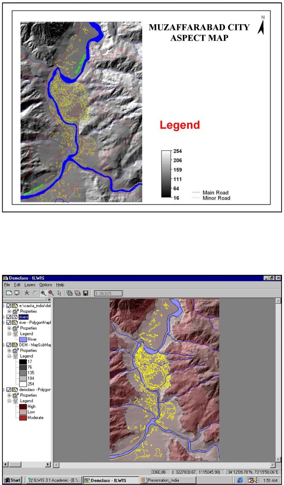
3 MUZAFFARABAD CITY ASPECT MAP
4 Natural Hazard: The probability of occurrence, within a specific period of time, in a given area,, of a potentially damaging natural phenomenon. Natural events become a hazard if they might occur in an area where they might destroy human lives and seriously disturb the human activities. They become a disaster when they actually occur & strike human lives & property. Impact of Hazards in Developing Countries In Developing Countries, people are affecting by disasters on a large scale, due to: 1. Geographical location. 2. Dramatic increase in population. 3. Lack of money to implement measures to decrease loss of lives and property by disasters. These disasters are serious obstacles to economic and social development.

5 NEED OF GIS & RS AS INTEGRATED TOOLS FOR FLOOD RISK ASSESSMENT Nowadays GIS & RS are emerging as powerful tools for the assessment OF RISK & management of natural hazards. Due to these techniques, natural hazard mapping can be prepared now to delineate flood prone areas on the map. Such kind of maps will enable the authorities for quick assessment of potential impact of a natural hazard and initiation of appropriate measures for reducing the impact. Such data can help the planners and decision-makers to take positive and in time steps during pre-disaster situation. It will also help them during post-disaster activities for the assessment of damages and losses occurred due to flooding. OBJECTIVES OF THE STUDY To develop classified Risk assessment maps for the City. To delineate the infrastructure, which are vulnerable to flooding and other natural hazard. To create a Digital Elevation Model for the area. To develop landuse map for Muzaffarabad City

6
7

8
9

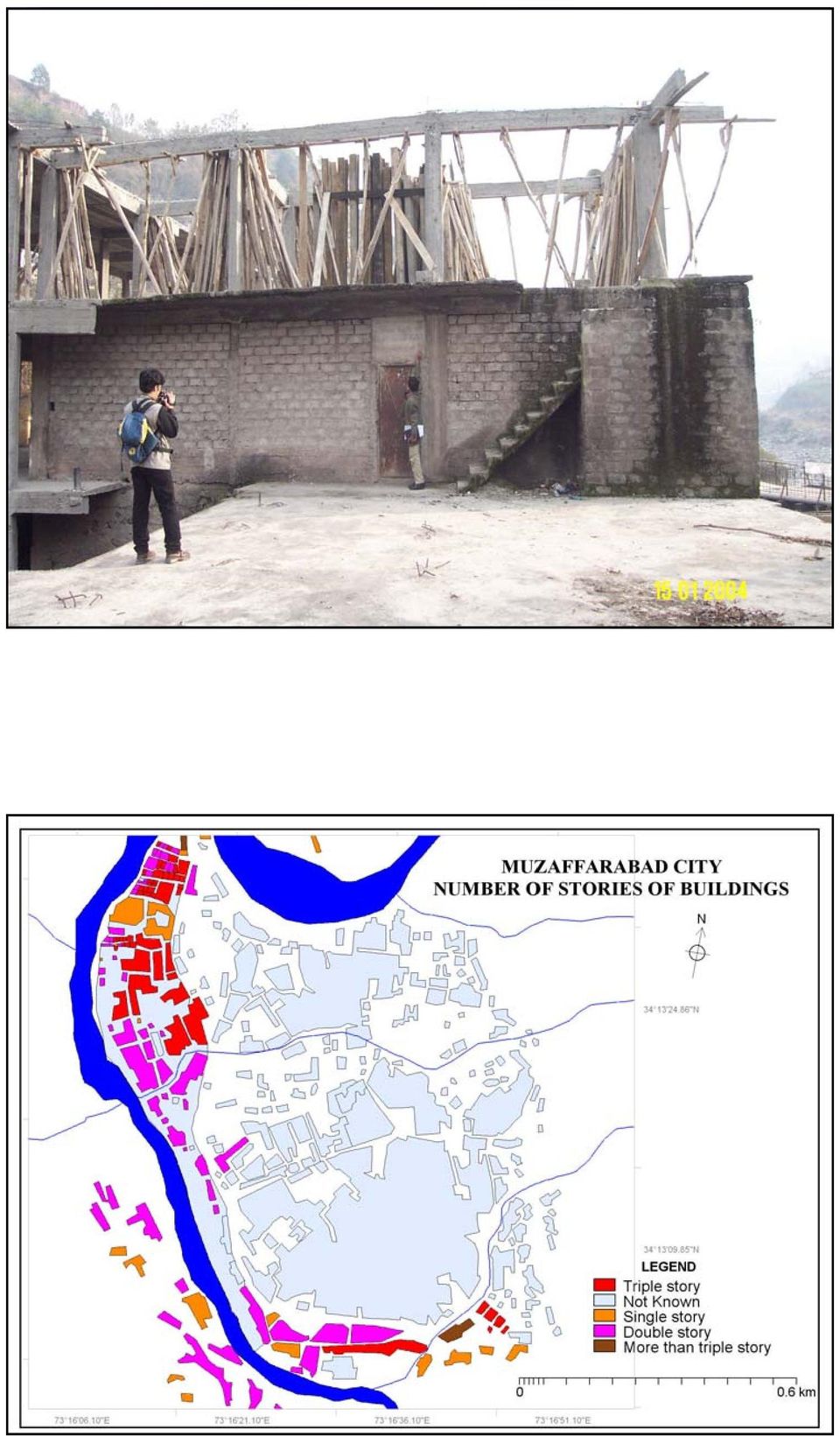
10 Can be converted into Classified Hazard categories by using slicing command Gave weight value in attribute tables to Land use, Material used in constructions,age of the buildings, Story's of the houses and Vulnerability of Parcels (Low weight for new houses/non Vul houses with good quality material) (High weight for Old houses/vul with low quality material)
 (High weight for Old houses/vul with")
11 CREATION OF VULNERABILITY MAPS Definition of Vulnerability: The (expected) degree of loss to a given element at risk, or a set of such elements, resulting from the occurrence of a natural phenomenon of a given magnitude, and expressed on a scale from 0 (no damage) to 1 (total loss).
 to 1")
12

13

14 Risk: The expected degree of loss due to a particular phenomenon. It is a function of both natural hazard and vulnerability. The population, buildings, civil engineering works, economic activity, public services, utilities & infrastructure, etc are elements which are at risk in a given area.

15 LEGEND

16

17 Pixel information window FINDINGS Low class residential houses are situated very near to the rivers. Main road to Mansehra, hiking track and some other roads are severely vulnerable. Some important Govt; offices were also found vulnerable to flooding. Risk assessment data is severely lacking in the concerned organization. The administrative authorities gave more stress to postdisaster type of activities during any natural hazard. GIS/RS labs are not present in these offices, similarly there is severe lack of computerized database.

18 RECOMMENDATIONS 1- Need of Hazard and Risk Assessment Mapping in the concerned organization. 2- Need of a Computerized GIS Database, GIS/RS laboratory in Federal Flood Commission & other related offices. 3- Acquisition of Satellite data (Radar data) during monsoon season from SUPARCO office. 4- Education & Training is needed. 4.1-Need of trained staff Planners, Decision-makers & Administrative officers Technical staff of the line departments

Flood Zone Investigation by using Satellite and Aerial Imagery
 Flood Zone Investigation by using Satellite and Aerial Imagery Younes Daneshbod Islamic Azad University-Arsanjan branch Daneshgah Boulevard, Islamid Azad University, Arsnjan, Iran Email: daneshbod@gmail.com
MONITORING INFORMATION SYSTEM
 + + = Chapter 7: Monitoring Information System world shelter people 7 MONITORING INFORMATION SYSTEM 7.1 Introduction Maldives Talking About Strengths and Weaknesses to Improve the Quality of the Programme
The Caribbean Disaster Mitigation Project: Supporting Sustainable Responses to Natural Hazards
 The Caribbean Disaster Mitigation Project: Supporting Sustainable Responses to Natural Hazards Steven Stichter Caribbean Disaster Mitigation Project (CDMP) Unit of Sustainable Development and Environment
DETECTING LANDUSE/LANDCOVER CHANGES ALONG THE RING ROAD IN PESHAWAR CITY USING SATELLITE REMOTE SENSING AND GIS TECHNIQUES
 ------------------------------------------------------------------------------------------------------------------------------- Full length Research Paper -------------------------------------------------------------------------------------------------------------------------------
Landslide hazard zonation using MR and AHP methods and GIS techniques in Langan watershed, Ardabil, Iran
 Landslide hazard zonation using MR and AHP methods and GIS techniques in Langan watershed, Ardabil, Iran A. Esmali Ouri 1* S. Amirian 2 1 Assistant Professor, Faculty of Agriculture, University of Mohaghegh
NATURAL DISASTER DATA AND INFORMATION MANAGEMENT SYSTEM
 NATURAL DISASTER DATA AND INFORMATION MANAGEMENT SYSTEM H. Assilzadeh a, *, S.B. Mansor a Institute of Advanced Technology (ITMA), University Putra Malaysia, 43400 UPM, Serdang hamid@cilix.org, shattri@eng.upm.edu.my
Natural Resource-Based Planning*
 Natural Resource-Based Planning* Planning, when done well, is among the most powerful tools available to communities. A solid plan, based on good natural resource information, guides rational land-use
Plan Plus Volume 1 No 1 2002 (117-123)
") Plan Plus Volume 1 No 1 2002 (117-123) APPLICATION OF GIS (GEOGRAPHIC INFORMATION SYSTEM) FOR LANDSLIDE HAZARD ZONATION AND MAPPING DISASTER PRONE AREA: A STUDY OF KULEKHANI WATERSHED, NEPAL Purna Chandra
Plan Plus Volume 1 No 1 2002 (117-123) APPLICATION OF GIS (GEOGRAPHIC INFORMATION SYSTEM) FOR LANDSLIDE HAZARD ZONATION AND MAPPING DISASTER PRONE AREA: A STUDY OF KULEKHANI WATERSHED, NEPAL Purna Chandra
An Introduction to FEMA Flood Map Updates and How it Affects You
 An Introduction to FEMA Flood Map Updates and How it Affects You Presented by Michael Baker Jr., Inc. on behalf of the City of Reno Agenda Session 1 5:30-6:00 FEMA Flood Map Changes Program Slide Show
THE CAGIS CONSORTIUM DATA SERVICES PRICING POLICY
 THE CAGIS CONSORTIUM DATA SERVICES PRICING POLICY AMENDED BY THE CAGIS POLICY BOARD ON June 6 th, 2014 Effective date: July 1st 2014 PART A Preamble PART B REGARDING SALE OF DATA SERVICE PRODUCTS TABLE
LEOworks - a freeware to teach Remote Sensing in Schools
 LEOworks - a freeware to teach Remote Sensing in Schools Wolfgang Sulzer Institute for Geography and Regional Science University of Graz Heinrichstrasse 36, A-8010 Graz/Austria wolfgang.sulzer@uni-graz.at
Probabilistic Risk Assessment Studies in Yemen
 Probabilistic Risk Assessment Studies in Yemen The catastrophic risk analysis quantifies the risks of hazard, exposure, vulnerability, and loss, thus providing the decision maker with the necessary information
METHODOLOGICAL GUIDE FOR PRE-DISASTER RECOVERY PLANNING PROCESSES Guidelines and actions for national, regional and local governments
 METHODOLOGICAL GUIDE FOR PRE-DISASTER RECOVERY PLANNING PROCESSES Guidelines and actions for national, regional and local governments Pre-Disaster Recovery Planning (Pre-DRP) It takes an era to build a
Application of Space Technology for Disaster monitoring and assessment current state in Vietnam
 Application of Space Technology for Disaster monitoring and assessment current state in Vietnam Lai Anh Khoi SPACE TECHNOLOGY INSTITUTE 8th GEOSS Asian Pacific Symposium Beijing, Sep. 09-11, 2015 Types
How To Understand And Understand The Flood Risk Of Hoang Long River In Phuon Vietnam
 FLOOD HAZARD AND RISK ASSESSMENT OF HOANG LONG RIVER BASIN, VIETNAM VU Thanh Tu 1, Tawatchai TINGSANCHALI 2 1 Water Resources University, Assistant Professor, 175 Tay Son Street, Dong Da District, Hanoi,
Application of Google Earth for flood disaster monitoring in 3D-GIS
 Disaster Management and Human Health Risk II 271 Application of Google Earth for flood disaster monitoring in 3D-GIS M. Mori & Y. L. Chan Department of Information and Computer Science, Kinki University,
HAZARD VULNERABILITY & RISK ASSESSMENT
 Hazard Vulnerability Analysis Purpose and Scope A Hazard Vulnerability Analysis (HVA) evaluates risk associated with a specific hazard. During this analysis, the hazard is evaluated for its probability
Lesson 5. After a Disaster: Recovery and Hazard Mitigation Programs. Disaster Assistance
 Introduction The previous four lessons focused on pre-disaster mitigation: developing a program, and writing and implementing a hazard mitigation plan. The Disaster Mitigation Act of 2000 (DMA 2000) encourages
Chapter 4 Natural Hazards and Emergency Management
 Chapter 4 Natural Hazards and Emergency Management Chapter 4 Natural Hazards and Emergency Management 1.0 NATURAL HAZARDS Littleton has a relatively low risk from natural hazards. The most likely natural
HAZARD RISK ASSESSMENT, MONITORING, MAINTENANCE AND MANAGEMENT SYSTEM (HAMMS) FOR LANDSLIDE AND FLOOD. Mohd. Nor Desa, Rohayu and Lariyah, UNITEN
 FOR LANDSLIDE AND FLOOD. Mohd. Nor Desa, Rohayu and Lariyah, UNITEN") HAZARD RISK ASSESSMENT, MONITORING, MAINTENANCE AND MANAGEMENT SYSTEM (HAMMS) FOR LANDSLIDE AND FLOOD Mohd. Nor Desa, Rohayu and Lariyah, UNITEN WHAT WE HAVE IN MIND AND FROM OUR PREVIOUS PROJECT CONTRIBUTION
HAZARD RISK ASSESSMENT, MONITORING, MAINTENANCE AND MANAGEMENT SYSTEM (HAMMS) FOR LANDSLIDE AND FLOOD Mohd. Nor Desa, Rohayu and Lariyah, UNITEN WHAT WE HAVE IN MIND AND FROM OUR PREVIOUS PROJECT CONTRIBUTION
GIS BASED LAND INFORMATION SYSTEM FOR MANDAL SOUM, SELENGE AIMAG OF MONGOLIA
 GIS BASED LAND INFORMATION SYSTEM FOR MANDAL SOUM, SELENGE AIMAG OF MONGOLIA B. Tuul GTZ, Land Management and Fiscal Cadastre project, Government building 12, ALAGCaC, Ulaanbaatar, Mongolia tuul1119@yahoo.com,
3D Model of the City Using LiDAR and Visualization of Flood in Three-Dimension
 3D Model of the City Using LiDAR and Visualization of Flood in Three-Dimension R.Queen Suraajini, Department of Civil Engineering, College of Engineering Guindy, Anna University, India, suraa12@gmail.com
Operational methodology to assess flood damages in Europe
 IIASA-DPRI 2008 Operational methodology to assess flood damages in Europe Contributors: Nicola Lugeri, Carlo Lavalle, Elisabetta Genovese 1 Focus of ADAM work on extremes Types Floods, Heat-wave, Drought
Portion of Smith Tract and Weber Tract Flood Contingency Map
 ACEC California 2012 Engineering Excellence Awards SAN JOAQUIN COUNTY FLOOD CONTINGENCY MAPPING FEDERAL EMERGENCY MANAGEMENT AGENCY (FEMA) PILOT PROJECT San Joaquin County Office of Emergency Services
1. GENERAL ADVISORY BASE FLOOD ELEVATION (ABFE) QUESTIONS
 QUESTIONS") INTRODUCTION As communities begin to recover from the devastating effects of Hurricane Sandy, it is important to recognize lessons learned and to employ mitigation actions that ensure structures are rebuilt
INTRODUCTION As communities begin to recover from the devastating effects of Hurricane Sandy, it is important to recognize lessons learned and to employ mitigation actions that ensure structures are rebuilt
VULNERABILITY ANALYSIS AND RISK ASSESSMENT FOR SEISMIC AND FLOOD HAZARD IN TURIALBA CITY, COSTA RICA
 VULNERABILITY ANALYSIS AND RISK ASSESSMENT FOR SEISMIC AND FLOOD HAZARD IN TURIALBA CITY, COSTA RICA Figure 5.4. Damage maps for By Muh Aris Marfai Jacob Kamwaria Njagih International Institute for Geo-information
PLANNING FOR POST-DISASTER RECOVERY BRIEFING PAPERS FLOOD INSURANCE AND DESIGN REQUIREMENTS
 06 PLANNING FOR POST-DISASTER RECOVERY BRIEFING PAPERS FLOOD INSURANCE AND DESIGN REQUIREMENTS Flood losses are increasing nationwide. A community may take more than a decade to fully recover from a flood,
Predicting Seismic Vulnerable Zones using GIS. Outline of the presentation. Objectives. Risk Mapping Overview Factor Maps. Three levels of Zonation
 Predicting Seismic Vulnerable Zones using GIS by K.S.A. Dinesh Kumar Research Scholar, Anna University & Lecturer in Civil Engineering Dept. National Institute of Technical Teachers Training & Research
A disaster occurs at the point of contact between social activities and a natural phenomenon of unusual scale.
 Hazard Mapping and Vulnerability Assessment Mr. Toshiaki Udono Senior Project Manager, Kansai Division, PASCO Corporation, Japan Mr. Awadh Kishor Sah Project Manager, Project Implementation Department,

Substantial Improvement/Substantial Damage for Floodplain Administrators Mitigation Fact Sheet
 Substantial Improvement/Substantial Damage for Floodplain Administrators Mitigation Fact Sheet Substantial Improvement/Substantial Damage are everyday issues, not just post-disaster; and they apply to
Risk MAP Project Coordination Meeting: Burlington County, NJ. FEMA REGION II May 8, 2013 Westampton, New Jersey
 Risk MAP Project Coordination Meeting: Burlington County, NJ FEMA REGION II May 8, 2013 Westampton, New Jersey Agenda Introductions Purpose of this Meeting Risk MAP Program Overview Anticipated Project
Capturing building inventory data for earthquake risk assessment: The GEM perspective. Risk Global Component Inventory Data Capture Tools
 Risk Global Component Inventory Data Capture Tools Capturing building inventory data for earthquake risk assessment: The GEM perspective NCEO/CEOI Joint Science Conference, Nottingham 2/9/212 John Bevington,
Response, Recovery, and Resilience
 Response, Recovery, and Resilience KATHLEEN TIERNEY ATURAL HAZARDS CENTER NIVERSITY OF COLORADO RESILIENCE THE ABILITYOF PHYSICAL SYSTEMS AND SOCIAL UNITS TO: Mitigate Hazards Contain the Effects of Disasters
Michigan Tech Research Institute Wetland Mitigation Site Suitability Tool
 Michigan Tech Research Institute Wetland Mitigation Site Suitability Tool Michigan Tech Research Institute s (MTRI) Wetland Mitigation Site Suitability Tool (WMSST) integrates data layers for eight biophysical
Anchorage All-Hazard Mitigation Plan October 2004
 EXECUTIVE SUMMARY The Municipality of Anchorage (MOA) is vulnerable to a wide range of natural, technological, and human/societal hazards including earthquakes, avalanches, and hazardous material accidents.
Resources FEMA CURRICULUM. FEMA Mitigation Curriculum MITIGATION TRAINING. Resident Courses
 MITIGATION TRAINING is provided mainly through the courses and programs of the Emergency Management Institute (EMI) located in Emmitsburg, Maryland. The EMI serves as the focal point for the development
Geographic Information Systems
 Jan Coyne, William C. Bell, Mary Maureen Brown, Chad Rupert, and James Nolan Geographic Information Systems A geographic information system (GIS) combines database management and analysis functions with
Pre-Disaster Planning. for Permanent Housing Recovery PLANNING STRATEGY
 Pre-Disaster Planning for Permanent Housing Recovery volume two PLANNING STRATEGY U.S. Department of Housing and Urban Development Office of Policy Development and Research Visit PD&R s website www.huduser.org
Two messages... Council of Europe. Flood Research
 Bonn, 12 May 2003 Insurance and Maladaptation Professor David Crichton University College London Middlesex University, London University of Dundee, Scotland Fellow of the Chartered Insurance Institute
Real Time Flood Alert System (RTFAS) for Puerto Rico
 for Puerto Rico") Prepared in cooperation with the Puerto Rico Emergency Management Agency (PREMA) Real Time Flood Alert System (RTFAS) for Puerto Rico Overview The Real Time Flood Alert System is a web-based computer program,
Prepared in cooperation with the Puerto Rico Emergency Management Agency (PREMA) Real Time Flood Alert System (RTFAS) for Puerto Rico Overview The Real Time Flood Alert System is a web-based computer program,
Emergency Preparedness
 Summit Health Consulting Emergency Preparedness You never know when an emergency will happen. But you can take proactive steps to prepare for emergencies so you will know what to do in the event that one
A CONCEPT OUTLINE ESTABLISHING THE
 Updated 13 November 2009 A CONCEPT OUTLINE ESTABLISHING THE Philippine GIS Data Clearinghouse (PhilGIS) www.philgis.org Prepared by Al Tongco, Ph.D. Stillwater, Oklahoma, U.S.A. al_tongco@yahoo.com Introduction
Near Real Time Flood Mapping & Monitoring
 Near Real Time Flood Mapping & Monitoring C.M.BHATT Disaster Management Support Division National Remote Sensing Centre (NRSC / ISRO) Hyderabad, India flood@nrsc.gov.in 7-8 December, 2014 ISPRS PRE-SYMPOSIUM
ANNEX P HAZARD MITIGATION
 ANNEX P HAZARD MITIGATION CITY OF HOUSTON TABLE OF CONTENTS ANNEX P MITIGATION COVER... i AUTHORITY & IMPLEMENTATION... ii TABLE OF CONTENTS... iii 1. AUTHORITY...1 2 PURPOSE...1 3. EXPLANATION OF TERMS...1
LCCS & GeoVIS for land cover mapping. Experience Sharing of an Exercise
 LCCS & GeoVIS for land cover mapping Experience Sharing of an Exercise Forest Survey of India Subhash Ashutosh Joint Director Study Area Topographic sheet 53J4 Longitude - 78ºE - 78º15'E Latitude - 30ºN
Guide to Physical Security Planning & Response
 Guide to Physical Security Planning & Response For Hospitals, Medical & Long Term Care Facilities Includes comprehensive section on evacuation best practices All hazards planning & response Templates Best
Community Restoration/Relocation Planning Model for Safety, Convenience and Sustainability
 Community Restoration/Relocation Planning Model for Safety, Convenience and Sustainability Maoto OKUMURA ), Jinyong KIM ) and Kazuai OKUBO ) ) momr@m.tohou.ac.jp Member of IDRiM, Professor, International
American Planning Association
 American Planning Association Planning for Post-Disaster Recovery Session 1 Moderator: Tim Gelston, FEMA Region 8 Speakers: Kenneth C. Topping, FAICP, Topping Associates International J. Barry Hokanson,
Association of State Flood Managers Annual Conference Wednesday, June 4, 2014
 Association of State Flood Managers Annual Conference Wednesday, June 4, 2014 Hillsborough County, In the Trenches Local Mitigation Eugene Henry, CFM, AICP Hazard Mitigation Manager Floodplain Administrator
1. Why is the City of Dickinson getting new flood hazard maps?
 FREQUENTLY ASKED QUESTIONS 1. Why is the City of Dickinson getting new flood hazard maps? Flood hazard maps, also known as Flood Insurance Rate Maps (FIRMs), are important tools in the effort to protect
HURRICANE DISASTER PREPARATION CHECKLIST AND BUSINESS CONTINUITY PLAN
 HURRICANE DISASTER PREPARATION CHECKLIST AND BUSINESS CONTINUITY PLAN G. Thomas Harper, Esq., Editor Florida Employment Law Letter HARPER GERLACH, PL 4110 Southpoint Boulevard Suite 228 Jacksonville, Florida
NOTE: NOI must be submitted in digital form. State Government
 Generator Projects Notice Of Interest (NOI) Colorado DHSEM Hazard Mitigation NOI Generator Projects THIS SECTION FOR STATE USE ONLY DISASTER: Colorado Point of Contact: Colorado Identification Number:
Remote sensing and GIS applications in coastal zone monitoring
 Remote sensing and GIS applications in coastal zone monitoring T. Alexandridis, C. Topaloglou, S. Monachou, G.Tsakoumis, A. Dimitrakos, D. Stavridou Lab of Remote Sensing and GIS School of Agriculture
Basic system of measures for flood damage mitigation in Japan. Preparedness for major floods
 Basic system of measures for flood damage mitigation in Japan Preparedness for major floods Past major floods and state-level efforts Role of the 2 MLIT's disaster prevention efforts Disaster prevention
Creating a File Geodatabase
 Creating a File Geodatabase Updated by Thomas Stieve January 06, 2012 This exercise demonstrates how to create a file geodatabase in ArcGIS 10; how to import existing data into the geodatabase, and how
DEVELOPING FLOOD VULNERABILITY MAP FOR NORTH KOREA INTROUDUCTION
 DEVELOPING FLOOD VULNERABILITY MAP FOR NORTH KOREA Soojeong Myeong, Research Fellow Hyun Jung Hong, Researcher Korea Environment Institute Seoul, South Korea 122-706 sjmyeong@yahoo.com hjhong@kei.re.kr
Security Systems EMERGENCY MANAGEMENT. In security you cannot choose the second best option. indracompany.com
 Security Systems EMERGENCY MANAGEMENT In security you cannot choose the second best option indracompany.com EMERGENCY MANAGEMENT EMERGENCY MANAGEMENT EMERGENCY C4i CENTRE Crisis management and preparednesss
EVALUATING DAMAGE ASSESSMENT OF BREACHES ALONG THE EMBANKMENTS OF INDUS RIVER DURING FLOOD 2010 USING REMOTE SENSING TECHNIQUES
 EVALUATING DAMAGE ASSESSMENT OF BREACHES ALONG THE EMBANKMENTS OF INDUS RIVER DURING FLOOD 2010 USING REMOTE SENSING TECHNIQUES R. Ahmad a, *, Daniyal a a Space Technology Applications Directorate, Space
Identifying how the strategies used to evaluate flood damage can affect the results of the evaluation
 Identifying how the strategies used to evaluate flood damage can affect the results of the evaluation Julian ELEUTERIO (1)(2) Anne ROZAN (1), Robert MOSE (2) (1) UMR Cemagref/ENGEES Management of Public
Building Caribbean GeoNode Platform in Support of Climate Risk Management Jacob Opadeyi, PhD
 Building Caribbean GeoNode Platform in Support of Climate Risk Management Jacob Opadeyi, PhD Our Highly Vulnerable Region Housing developments on drainage channels and steep slopes Unapproved development
DISASTER DISASTER MANAGEMENT CRISIS INFORMATICS GIS IN DIFFEERENT STAGES OF DISASTER MANAGEMENT
 APPLICATION OF GIS AND REMOTE SENSING IN DISASTER PRONE AREAS: A CASE STUDY IN COASTAL KERALA DISASTER Disaster is an unpleasant event than occurs with little or no warning which results in economic disruption,
All-Hazard Continuity of Operations Plan. [Department/College Name] [Date]
![All-Hazard Continuity of Operations Plan. [Department/College Name] [Date]](/thumbs/39/18175711.jpg "All-Hazard Continuity of Operations Plan. [Department/College Name] [Date]") d All-Hazard Continuity of Operations Plan [Department/College Name] [Date] TABLE OF CONTENTS SECTION I: INTRODUCTION... 3 Executive Summary... 3 Introduction... 3 Goal... 4 Purpose... 4 Objectives...
d All-Hazard Continuity of Operations Plan [Department/College Name] [Date] TABLE OF CONTENTS SECTION I: INTRODUCTION... 3 Executive Summary... 3 Introduction... 3 Goal... 4 Purpose... 4 Objectives...
Argonne National Laboratory
 Argonne National Laboratory Using Climate Data to Inform Critical Infrastructure Resilience and Urban Sustainability Decisionmaking National Academy of Sciences Roundtable on Science and Technology for
Social Work Education for Disaster Recovery and Community Building by M.C. Terry Hokenstad Case Western Reserve University
 Social Work Education for Disaster Recovery and Community Building by M.C. Terry Hokenstad Case Western Reserve University presented at International Seminar on Disaster Planning, Management and Relief
Appendix B. Introduction to Landslide Evaluation Tools Mapping, Remote Sensing, and Monitoring of Landslides
 Appendix B. Introduction to Landslide Evaluation Tools Mapping, Remote Sensing, and Monitoring of Landslides 66 The Landslide Handbook A Guide to Understanding Landslides Part 1. Mapping Maps are a useful
INAYAT ULLAH. Lecturer at COMSATS Institute of Information Technology Attock-Campus-Pakistan
 Present Address Department of Management Sciences, COMSATS Institute of Information Technology, Attock Campus, Kamra Road, Attock City-Punjab-Pakistan Cell: +92-346-8984308 +92-315-9700819 Skype: inayat.amin15
Graduate School of Disaster Prevention Kangwon National University. http://college.kangwon.ac.kr/prevention/main.jsp
 Graduate School of Disaster Prevention Kangwon National University 1joongang-Ro Samcheok-city, Gangwon-Do, Republic of Korea http://college.kangwon.ac.kr/prevention/main.jsp Outline Natural disasters such
GEOLOGY What can I do with this major?
 GEOLOGY What can I do with this major? ENERGY (Oil, Coal, Gas, Other Energy Sources) Geophysics Economic Geology Paleontology Fossil Energy Petroleum industry including oil and gas exploration, production,
Keynote 2: What is Landslide Hazard? Inventory Maps, Uncertainty, and an Approach to Meeting Insurance Industry Needs
 Keynote 2: What is Landslide Hazard? Inventory Maps, Uncertainty, and an Approach to Meeting Insurance Industry Needs Jeffrey R Keaton Richard J Roth, Jr Amec Foster Wheeler Los Angeles, USA Consulting
Technology Trends In Geoinformation
 Technology Trends In Geoinformation Dato Prof. Sr Dr. Abdul Kadir Bin Taib Department of Survey and Mapping Malaysia (JUPEM) Email: drkadir@jupem.gov.my www.jupem.gov.my NGIS 2008 3 rd. National GIS Conference
TERRITORIAL PLANNING FOR THE MANAGEMENT OF RISK IN EUROPE
 , Territorial págs. Planning 383-388 for the Management of Risk in Europe TERRITORIAL PLANNING FOR THE MANAGEMENT OF RISK IN EUROPE Mark Fleischhauer, Stefan Greiving & Sylvia Wanczura Universität Dortmund
How To Calculate Flood Damage Potential In European Landscape
 Background/Introduction RISK ANALYSIS MODULE 3, CASE STUDY 2 Flood Damage Potential at European Scale By Dr. Peter Burek There is good reason to be concerned about the growth of flood losses in Europe.
State Mitigation Plan Review Guide. Released March 2015 Effective March 2016 FP 302-094-2
 State Mitigation Plan Review Guide Released March 2015 Effective March 2016 FP 302-094-2 This page is intentionally blank. Table of Contents List of Acronyms and Abbreviations... iii SECTION 1: INTRODUCTION...
Utilizing satellite-based information for disaster risk assessment- why and how?
 Utilizing satellite-based information for disaster risk assessment- why and how? Peeranan Towashiraporn ADPC Session 1, UN International Conference on Space-based Technologies for Disaster Management September
Emergency Support Function #14 Long Term Community Recovery and Mitigation
 Emergency Support Function #14 Long Term Community Recovery and Mitigation Primary Agency FEMA Board of Visitors Radford University Cabinet Secondary/Support Agencies Radford University Office of Emergency
A Sub-Scheme under AMRUT
 1 A Sub-Scheme under AMRUT TITLE Sub-Mission under AMRUT - Formulation of GIS-Based Master Plans for AMRUT Cities 1. OBJECTIVES The objective is to develop common digital geo-referenced base maps and land
Disaster Risk Management: prevention and urgent repair procedures for infrastructure and facilities
 Disaster Risk Management: prevention and urgent repair procedures for infrastructure and facilities Jacob Greenstein Ph.D, PE, EGAT/ I&E EGAT workshop-december 2009 1 Natural disasters-new trends Natural
Aneeqa Syed [Hatfield Consultants] Vancouver GIS Users Group Meeting December 8, 2010
![Aneeqa Syed [Hatfield Consultants] Vancouver GIS Users Group Meeting December 8, 2010](/thumbs/27/11179985.jpg "Aneeqa Syed [Hatfield Consultants] Vancouver GIS Users Group Meeting December 8, 2010") NEAR-REAL-TIME FLOOD MAPPING AND MONITORING SERVICE Aneeqa Syed [Hatfield Consultants] Vancouver GIS Users Group Meeting December 8, 2010 SLIDE 1 MRC Flood Service Project Partners and Client Hatfield
NEAR-REAL-TIME FLOOD MAPPING AND MONITORING SERVICE Aneeqa Syed [Hatfield Consultants] Vancouver GIS Users Group Meeting December 8, 2010 SLIDE 1 MRC Flood Service Project Partners and Client Hatfield
Development and Recovering From Disaster
 Development and Recovering From Disaster hasan.coban@kalkinma.gov.tr International Symposium on Disaster Economics 3-5 April 2013, Istanbul Natural Disaster in Turkey Other disasters 4% Avalanche 2% Multiple
Assessing the implementation of Rawalpindi s Guided Development Plan through GIS and Remote Sensing Muhammad Adeel
 Assessing the implementation of Rawalpindi s Guided Development Plan through GIS and Remote Sensing Muhammad Adeel (Lecturer Muhammad Adeel, Institute of Geographical Information Systems, NUST, H-12 Islamabad,
Emergency Management Service. early warning FLOOD AND FIRE ALERTS. Space
 Emergency Management Service early warning FLOOD AND FIRE ALERTS Space 1 Copernicus at a Glance Copernicus is the European Union s Earth Observation programme: a user-driven space programme under civil
1. What is the Disaster Recovery Enhancement Fund (DREF)?
?") Frequently Asked Questions Regarding the Disaster Recovery Enhancement Fund (DREF) U.S. Department of Housing and Urban Development Office of Community Planning and Development June 23, 2010 1. What is
Frequently Asked Questions Regarding the Disaster Recovery Enhancement Fund (DREF) U.S. Department of Housing and Urban Development Office of Community Planning and Development June 23, 2010 1. What is
Polk Commerce Centre CRA Spine Road Alignment Study
 Polk Commerce Centre CRA Spine Road Alignment Study Florida Polytech Pace Road (LIMIT) Berkley Road Williams DRI Proposed Alignment Polk Commerce Centre CRA Boundary Braddock Road (LIMIT) Lake Myrtle Sports
Flood Damage Assessment in Taipei City, Taiwan
 Flood Damage Assessment in Taipei City, Taiwan Ming-Hsi Hsu 1, Meng-Yuan Tsai, Yi-Chieh Lin 3, Albert S. Chen 4, Michael J. Hammond 5, Slobodan Djordjević 6 & David Butler 7 1 National Taiwan University,
RESULT, ANALYSIS AND DISCUSSION
 Chapter 6 RESULT, ANALYSIS AND DISCUSSION As we have already mentioned that our proposed methodology works in two phases, i.e., i) Application development when there is no in the database/application (First
Laurence W. Carstensen Jr. Department of Geography Virginia Polytechnic Institute and State University Blacksburg, VA U.S.A. 24061
 REGIONAL LAND INFORMATION SYSTEM DEVELOPMENT USING RELATIONAL DATABASES AND GEOGRAPHIC INFORMATION SYSTEMS Laurence W. Carstensen Jr. Department of Geography Virginia Polytechnic Institute and State University
The Role of GIS in a Disaster Recovery Plan 2010 GIS-T CONFERENCE
 The Role of GIS in a Disaster Recovery Plan 2010 GIS-T CONFERENCE S A N D Y M E H L H O R N Introduction Four phases of disaster related planning Mitigation Preparation Response Recovery Considerable emphasis
Management Information System. Examiner 1
 Practical Date Sheet for B.Com Part - I Name of Colleges: Govt, College of Management Sciences, Abbottabad GOVERNMENT COLLEGE OF MANAGEMENT SCIENCES, ABBOTTABAD. Management Information System SESSION:
ABSTRACT INTRODUCTION PURPOSE
 EVALUATION OF TSUNAMI DISASTER BY THE 2011 OFF THE PACIFIC COAST OF TOHOKU EARTHQUAKE IN JAPAN BY USING TIME SERIES SATELLITE IMAGES WITH MULTI RESOLUTION Hideki Hashiba Associate Professor Department
EARTHQUAKE DISASTER GIS AND SPATIAL-TEMPORAL PATTERN OF EARTHQUAKE DISASTERS IN CHINA1
 EARTHQUAKE DISASTER GIS AND SPATIAL-TEMPORAL PATTERN OF EARTHQUAKE DISASTERS IN CHINA1 Mao Feng 1 and Ma Jin feng 2 and Zhou Wen sheng 3 1 Professor,School of Architecture,Tsinghua University, BeiJing.
Chincha and Cañete, Peru, Based
 Reconstruction of Ica, Pisco, Chincha and Cañete, Peru, Based on Updated Hazard Maps Julio Kuroiwa Professor emeritus National University of Engineering and UNDP Reconstruction Program/Sustainable Cities.
Modelling floods and damage assessment using GIS
 HydroGIS 96: Application of Geographic Information Systems in Hydrology and Water Resources Management (Proceedings of the Vienna Conference, April 1996). IAHS Publ. no. 235, 1996. 299 Modelling floods
e-cfr Data is current as of July 10, 2012
 Page 1 of 7 Home Page > Executive Branch > Code of Federal Regulations > Electronic Code of Federal Regulations e-cfr Data is current as of July 10, 2012 Title 13: Business Credit and Assistance PART 123
Application of Knowledge Management Framework as a Decision-Support System for Disaster Management in Metropolitan Areas Tehran as the Case Study
 reviewed paper Application of Knowledge Management Framework as a Decision-Support System for Disaster Management in Metropolitan Areas Tehran as the Case Study Zohreh A. Daneshpour, Alireza Fallahi, Asrin
Pike County General Health District. Emergency Response Plan
 Pike County General Health District Emergency Response Plan Updated October 2014 Basic Plan Primary Agency Support Agencies Introduction Purpose Scope Phases of Emergency Management Situations Assumptions
Ejemplos de evaluación de riesgo
 Ejemplos de evaluación de riesgo RISK ASSESSMENT RISK = HAZARD * VULNERABILITY * AMOUNT Hazard= PROBABILITY of event with a certain magnitude Vulnerability = Degree of damage. Function of: magnitude of
CASE STUDY. Jefferson County EMA Alabama Recovery Plan
 Jefferson County EMA Alabama Recovery Plan NOTE: Jefferson County EMA contracted with ERI International / All Hands Consulting to fully develop the county's recovery plan and program. The original concept
German Earth Observation Systems and Programs Capacities for nation building
 German Earth Observation Systems and Programs Capacities for nation building German Aerospace Center, DLR, Earth Observation Center, EOC German Remote Sensing Data Center, DFD Gunter Schreier Deputy Director
Chapter IX: Strategic Planning for Disaster Recovery
 Chapter IX: Strategic Planning for Disaster Recovery 82 Disaster recovery planning and preparedness is no longer strictly for communities that regularly experience flooding, forest fires or hurricanes.